Bridge Statistics for Monroe, Michigan (MI)
Condition, Traffic, Stress, Structural Evaluation, Project Costs
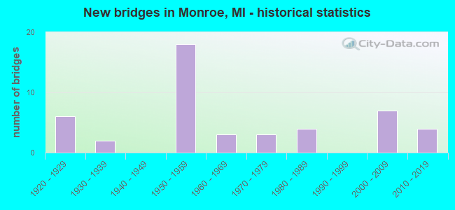
- New bridges - historical statistics
- 61920-1929
- 21930-1939
- 181950-1959
- 31960-1969
- 31970-1979
- 41980-1989
- 72000-2009
- 42010-2019

- Reconstructed bridges - Historical Statistics
- 31960-1969
- 11970-1979
- 21980-1989
- 31990-1999
- 32000-2009
- 52010-2019


- Bridge Condition - Deck
- 3.0%Excellent
- 24.2%Very good
- 24.2%Good
- 36.4%Satisfactory
- 6.1%Fair
- 6.1%Poor

- Bridge Condition - Superstructure
- 21.2%Very good
- 21.2%Good
- 30.3%Satisfactory
- 21.2%Fair
- 3.0%Poor
- 3.0%Critical

- Bridge Condition - Substructure
- 6.1%Very good
- 36.4%Good
- 36.4%Satisfactory
- 15.2%Fair
- 6.1%Poor

- Bridge Condition - Channel
- 6.5%Excellent
- 9.7%Very good
- 25.8%Good
- 45.2%Satisfactory
- 6.5%Fair
- 6.5%Poor

- Bridge Condition - Culverts
- 16.7%Very good
- 33.3%Good
- 50.0%Satisfactory
Find on map >> Show street view
Structure Number: 714, Location: 1000 FT E OF CARTER RD (Lat: 43.739933, Lng: -84.123458), Route carried "on" structure: County highway , Year Built: 2000, Status: Open, Structure Length: 1.89m (6.20ft), Average Daily Traffic: 542 (year 2000), Truck Traffic: 7%, Average Future Daily Traffic: 867 (year 2020), Design Load: HS 20, Features Intersected: N BR KAWKAWLIN RIVER, Facility Carried by Structure: LINWOOD ROAD
Minimum Vertical Clearance: 30.48m (100.00ft), Kilometerpoint: 3.505, Lanes on structure: 2, Owner: County Highway Agency, Approaching Roadway Width: 6.7m (22.0ft), Skew: 7 degrees, Material/Design: Prestressed concrete, Design/Construction: Box Beam or Girders - Multiple, Number Of Spans In Main Unit: 1, Length of Maximum Span: 18.3m (60.0ft), Curb-To-Curb Width: 8.5m (27.9ft), Out-to-Out Width: 11.4m (37.4ft)
Condition: Deck: Satisfactory, Superstructure: Good, Substructure: Good, Channel: Good, Operating Rating: 50.9 metric tons, Method Used To Determine Operating Rating: Load and Resistance Factor Rating (LRFR) rating reported by rating factor(RF) method using HL-93 loadings, Inventory Rating: 39.2 metric tons, Method Used To Determine Inventory Rating: Load and Resistance Factor Rating (LRFR) rating reported by rating factor(RF) method using HL-93 loadings, Structural Evaluation: Better than present minimum criteria, Deck Geometry: Somewhat better than minimum adequacy, Waterway Adequacy: Equal to present desirable criteria, Approach Roadway Alignment: Equal to present desirable criteria, Length Of Structure Improvement: 2.20m (7.22ft), Designated Inspection Frequency: Every 24 months, Inspection Date: May 2020, Bridge Improvement Cost: $370,000, Roadway Improvement Cost: $70,000, Total Project Cost: $480,000, Deck Structure Type: Concrete Precast Panels, Wearing Surface/Protective System: Wearing Surface: Bituminous, Deck Protection: Epoxy Coated Reinforcing
Find on map >> Show street view
Structure Number: 741, Location: 1000 FT N OF NEUMAN RD (Lat: 43.841906, Lng: -84.006408), Route carried "on" structure: County highway , Year Built: 1935, Status: Posted for load, Structure Length: 0.73m (2.40ft), Average Daily Traffic: 393 (year 2000), Truck Traffic: 7%, Average Future Daily Traffic: 472 (year 2020), Design Load: H 15, Features Intersected: PINCONNING RIVER, Facility Carried by Structure: FRASER ROAD
Minimum Vertical Clearance: 30.48m (100.00ft), Kilometerpoint: 19.376, Lanes on structure: 2, Owner: County Highway Agency, Approaching Roadway Width: 8.5m (27.9ft), Material/Design: Steel, Design/Construction: Stringer/Multi-beam, Number Of Spans In Main Unit: 1, Length of Maximum Span: 6.7m (22.0ft), Curb-To-Curb Width: 8.5m (27.9ft), Out-to-Out Width: 9.3m (30.5ft)
Condition: Deck: Poor, Superstructure: Critical, Substructure: Poor, Channel: Poor, Operating Rating: 15.9 metric tons, Method Used To Determine Operating Rating: Load Factor (LF) rating reported by rating factor (RF) method using MS18 loading, Inventory Rating: 9.4 metric tons, Method Used To Determine Inventory Rating: Load Factor (LF) rating reported by rating factor (RF) method using MS18 loading, Structural Evaluation: High priority of replacement, Deck Geometry: Equal to present minimum criteria, Waterway Adequacy: Equal to present minimum criteria, Approach Roadway Alignment: Equal to present desirable criteria, Bridge Posting: Required (Relationship of Operating Rating to Maximum Legal Load: > 39.9% below), Length Of Structure Improvement: 1.30m (4.27ft), Designated Inspection Frequency: Every 12 months, Inspection Date: April 2021, Bridge Improvement Cost: $218,000, Roadway Improvement Cost: $70,000, Total Project Cost: $300,000, Deck Structure Type: Concrete Cast-file-Place, Wearing Surface/Protective System: Wearing Surface: Bituminous
Find on map >> Show street view
Structure Number: 7124, Location: IN MONROE (Lat: 41.924089, Lng: -83.414536), Route carried "on" structure: US 24, Year Built: 1988, Status: Open, Structure Length: 16.06m (52.69ft), Average Daily Traffic: 27,951 (year 2007), Truck Traffic: 2%, Average Future Daily Traffic: 33,773 (year 2018), Design Load: HS 25 or greater, Features Intersected: RAISIN RIVER & ELM AVE
Minimum Vertical Clearance: 30.48m (100.00ft), Kilometerpoint: 24.527, Lanes on structure: 4, Lanes under structure: 2, Base Highway Network: Yes (Inventory Route: 430, Subroute: 1), Owner: State Highway Agency, Approaching Roadway Width: 14.6m (47.9ft), Material/Design: Prestressed concrete, Design/Construction: Stringer/Multi-beam, Number Of Spans In Main Unit: 7, Number Of Approach Spans: 1, Length of Maximum Span: 22.8m (74.8ft), Curb or Sidewalk Widths: Left: 2.7m (8.9ft), Right: 1.8m (5.9ft), Curb-To-Curb Width: 15.8m (51.8ft), Out-to-Out Width: 21.1m (69.2ft)
Condition: Deck: Good, Superstructure: Satisfactory, Substructure: Fair, Channel: Satisfactory, Operating Rating: 57.7 metric tons, Method Used To Determine Operating Rating: Load Factor (LF) rating reported by rating factor (RF) method using MS18 loading, Inventory Rating: 27.9 metric tons, Method Used To Determine Inventory Rating: Load Factor (LF) rating reported by rating factor (RF) method using MS18 loading, Structural Evaluation: Somewhat better than minimum adequacy, Deck Geometry: Meets minimum limits, Underclear: High priority of corrective action, Waterway Adequacy: Equal to present desirable criteria, Approach Roadway Alignment: Equal to present desirable criteria, Designated Inspection Frequency: Every 24 months, Inspection Date: August 2021, Deck Structure Type: Concrete Cast-file-Place, Wearing Surface/Protective System: Wearing Surface: Monolithic Concrete, Deck Protection: Epoxy Coated Reinforcing
Find on map >> Show street view
Structure Number: 7125, Location: 1.1 MI SW OF M-125 JNCT (Lat: 41.967242, Lng: -83.383822), Route carried "on" structure: US 24, Year Built: 2006, Status: Open, Structure Length: 1.04m (3.41ft), Average Daily Traffic: 18,282 (year 2007), Truck Traffic: 4%, Average Future Daily Traffic: 15,795 (year 2018), Design Load: HS 25 or greater, Features Intersected: SANDY CREEK
Minimum Vertical Clearance: 30.48m (100.00ft), Kilometerpoint: 30.059, Lanes on structure: 3, Base Highway Network: Yes (Inventory Route: 430, Subroute: 1), Owner: State Highway Agency, Approaching Roadway Width: 17.7m (58.1ft), Skew: 1 degrees, Material/Design: Concrete, Design/Construction: Culvert, Number Of Spans In Main Unit: 1, Length of Maximum Span: 9.8m (32.2ft), Curb-To-Curb Width: 17.2m (56.4ft), Out-to-Out Width: 18.7m (61.4ft)
Condition: Channel: Satisfactory, Culverts: Satisfactory, Operating Rating: 78.4 metric tons, Method Used To Determine Operating Rating: Load Factor (LF) rating reported by rating factor (RF) method using MS18 loading, Inventory Rating: 47.0 metric tons, Method Used To Determine Inventory Rating: Load Factor (LF) rating reported by rating factor (RF) method using MS18 loading, Structural Evaluation: Equal to present minimum criteria, Deck Geometry: Superior to present desirable criteria, Waterway Adequacy: Equal to present minimum criteria, Approach Roadway Alignment: Equal to present desirable criteria, Designated Inspection Frequency: Every 24 months, Inspection Date: August 2021, Deck Structure Type: Concrete Cast-file-Place, Wearing Surface/Protective System: Wearing Surface: Bituminous
Find on map >> Show street view
Structure Number: 7128, Location: 2.8 MI N OF MONROE (Lat: 41.955250, Lng: -83.396639), Route carried "on" structure: US 24, Year Built: 2012, Status: Open, Structure Length: 1.10m (3.61ft), Average Daily Traffic: 22,800 (year 2011), Truck Traffic: 3%, Average Future Daily Traffic: 25,400 (year 2031), Design Load: Greater than HL93, Features Intersected: LITTLE SANDY CREEK
Minimum Vertical Clearance: 30.48m (100.00ft), Kilometerpoint: 28.293, Lanes on structure: 5, Base Highway Network: Yes (Inventory Route: 430, Subroute: 1), Owner: State Highway Agency, Approaching Roadway Width: 18.3m (60.0ft), Skew: 3 degrees, Material/Design: Concrete, Design/Construction: Culvert, Number Of Spans In Main Unit: 1, Length of Maximum Span: 10.3m (33.8ft), Curb-To-Curb Width: 19.8m (65.0ft), Out-to-Out Width: 21.2m (69.6ft)
Condition: Channel: Satisfactory, Culverts: Good, Operating Rating: 46.0 metric tons, Method Used To Determine Operating Rating: Load and Resistance Factor Rating (LRFR) rating reported by rating factor(RF) method using HL-93 loadings, Inventory Rating: 35.3 metric tons, Method Used To Determine Inventory Rating: Load and Resistance Factor Rating (LRFR) rating reported by rating factor(RF) method using HL-93 loadings, Structural Evaluation: Better than present minimum criteria, Deck Geometry: Meets minimum limits, Waterway Adequacy: Equal to present minimum criteria, Approach Roadway Alignment: Equal to present minimum criteria, Designated Inspection Frequency: Every 24 months, Inspection Date: August 2021, Wearing Surface/Protective System: Wearing Surface: Bituminous
Find on map >> Show street view
Structure Number: 7129, Location: 1.5 MI SW OF M-125 (Lat: 41.964044, Lng: -83.388722), Route carried "on" structure: US 24, Year Built: 1925, Year Reconstructed: 2006, Status: Open, Structure Length: 4.20m (13.78ft), Average Daily Traffic: 18,282 (year 2007), Truck Traffic: 4%, Average Future Daily Traffic: 18,700 (year 2025), Design Load: HS 20, Features Intersected: CSX RR
Minimum Vertical Clearance: 30.48m (100.00ft), Kilometerpoint: 29.508, Lanes on structure: 3, Base Highway Network: Yes (Inventory Route: 430, Subroute: 1), Owner: State Highway Agency, Approaching Roadway Width: 13.4m (44.0ft), Material/Design: Steel continuous, Design/Construction: Stringer/Multi-beam, Number Of Spans In Main Unit: 3, Length of Maximum Span: 14.1m (46.3ft), Curb-To-Curb Width: 15.5m (50.9ft), Out-to-Out Width: 16.5m (54.1ft)
Condition: Deck: Satisfactory, Superstructure: Satisfactory, Substructure: Satisfactory, Operating Rating: 67.1 metric tons, Method Used To Determine Operating Rating: Load Factor (LF) rating reported by rating factor (RF) method using MS18 loading, Inventory Rating: 40.2 metric tons, Method Used To Determine Inventory Rating: Load Factor (LF) rating reported by rating factor (RF) method using MS18 loading, Structural Evaluation: Equal to present minimum criteria, Deck Geometry: Equal to present minimum criteria, Approach Roadway Alignment: Better than present minimum criteria, Designated Inspection Frequency: Every 24 months, Inspection Date: August 2021, Deck Structure Type: Concrete Cast-file-Place, Wearing Surface/Protective System: Wearing Surface: Latex Concrete
Find on map >> Show street view
Structure Number: 713, Location: 0.1 MI NE OF JCT M-125 (Lat: 41.981778, Lng: -83.371597), Route carried "on" structure: US 24, Year Built: 1931, Status: Open, Structure Length: 3.05m (10.01ft), Average Daily Traffic: 19,500 (year 2014), Truck Traffic: 4%, Average Future Daily Traffic: 22,650 (year 2034), Design Load: HS 20, Features Intersected: STONY CREEK
Minimum Vertical Clearance: 30.48m (100.00ft), Kilometerpoint: 31.980, Lanes on structure: 4, Base Highway Network: Yes (Inventory Route: 430, Subroute: 1), Owner: State Highway Agency, Approaching Roadway Width: 18.3m (60.0ft), Skew: 2 degrees, Material/Design: Steel, Design/Construction: Stringer/Multi-beam, Number Of Spans In Main Unit: 2, Length of Maximum Span: 14.6m (47.9ft), Curb-To-Curb Width: 21.0m (68.9ft), Out-to-Out Width: 22.0m (72.2ft)
Condition: Deck: Poor, Superstructure: Fair, Substructure: Fair, Channel: Satisfactory, Operating Rating: 62.2 metric tons, Method Used To Determine Operating Rating: Load Factor (LF) rating reported by rating factor (RF) method using MS18 loading, Inventory Rating: 36.9 metric tons, Method Used To Determine Inventory Rating: Load Factor (LF) rating reported by rating factor (RF) method using MS18 loading, Structural Evaluation: Somewhat better than minimum adequacy, Deck Geometry: Superior to present desirable criteria, Waterway Adequacy: Equal to present desirable criteria, Approach Roadway Alignment: Equal to present minimum criteria, Designated Inspection Frequency: Every 12 months, Inspection Date: August 2021, Deck Structure Type: Concrete Cast-file-Place, Wearing Surface/Protective System: Wearing Surface: Monolithic Concrete
Find on map >> Show street view
Structure Number: 714, Location: IN MONROE (Lat: 41.917650, Lng: -83.396700), Route carried "on" structure: State highway 125, Year Built: 1927, Year Reconstructed: 1990, Status: Open, Structure Length: 6.43m (21.10ft), Average Daily Traffic: 21,209 (year 2007), Average Future Daily Traffic: 28,912 (year 2018), Design Load: H 20, Features Intersected: RAISIN RIVER
Minimum Vertical Clearance: 30.48m (100.00ft), Kilometerpoint: 23.932, Lanes on structure: 4, Owner: State Highway Agency, Approaching Roadway Width: 14.0m (45.9ft), Material/Design: Prestressed concrete, Design/Construction: Stringer/Multi-beam, Number Of Spans In Main Unit: 5, Length of Maximum Span: 13.1m (43.0ft), Curb or Sidewalk Widths: Left: 2.2m (7.2ft), Right: 2.2m (7.2ft), Curb-To-Curb Width: 14.6m (47.9ft), Out-to-Out Width: 21.2m (69.6ft)
Condition: Deck: Good, Superstructure: Good, Substructure: Satisfactory, Channel: Satisfactory, Operating Rating: 62.2 metric tons, Method Used To Determine Operating Rating: Load Factor (LF) rating reported by rating factor (RF) method using MS18 loading, Inventory Rating: 37.3 metric tons, Method Used To Determine Inventory Rating: Load Factor (LF) rating reported by rating factor (RF) method using MS18 loading, Structural Evaluation: Equal to present minimum criteria, Deck Geometry: High priority of replacement, Waterway Adequacy: Equal to present desirable criteria, Approach Roadway Alignment: Equal to present desirable criteria, Designated Inspection Frequency: Every 24 months, Inspection Date: August 2021, Deck Structure Type: Concrete Cast-file-Place, Wearing Surface/Protective System: Wearing Surface: Monolithic Concrete
Find on map >> Show street view
Structure Number: 7141, Location: 2.3 MI S OF US-24 (Lat: 41.948872, Lng: -83.382631), Route carried "on" structure: State highway 125, Year Built: 2005, Status: Open, Structure Length: 1.07m (3.51ft), Average Daily Traffic: 14,211 (year 2007), Truck Traffic: 1%, Average Future Daily Traffic: 16,355 (year 2018), Design Load: HL 93, Features Intersected: LITTLE SANDY CREEK
Minimum Vertical Clearance: 30.48m (100.00ft), Kilometerpoint: 27.638, Lanes on structure: 5, Owner: State Highway Agency, Approaching Roadway Width: 21.6m (70.9ft), Material/Design: Prestressed concrete, Design/Construction: Box Beam or Girders - Single/Spread, Number Of Spans In Main Unit: 1, Length of Maximum Span: 9.2m (30.2ft), Curb-To-Curb Width: 21.6m (70.9ft), Out-to-Out Width: 22.4m (73.5ft)
Condition: Deck: Good, Superstructure: Good, Substructure: Good, Channel: Good, Operating Rating: 52.2 metric tons, Method Used To Determine Operating Rating: Load and Resistance Factor Rating (LRFR) rating reported by rating factor(RF) method using HL-93 loadings, Inventory Rating: 40.2 metric tons, Method Used To Determine Inventory Rating: Load and Resistance Factor Rating (LRFR) rating reported by rating factor(RF) method using HL-93 loadings, Structural Evaluation: Better than present minimum criteria, Deck Geometry: Somewhat better than minimum adequacy, Waterway Adequacy: Equal to present desirable criteria, Approach Roadway Alignment: Equal to present minimum criteria, Designated Inspection Frequency: Every 24 months, Inspection Date: August 2021, Deck Structure Type: Concrete Cast-file-Place, Wearing Surface/Protective System: Wearing Surface: Monolithic Concrete, Deck Protection: Epoxy Coated Reinforcing
Find on map >> Show street view
Structure Number: 7142, Location: 1.5 MI S OF US-24 (Lat: 41.958986, Lng: -83.377033), Route carried "on" structure: State highway 125, Year Built: 2005, Status: Open, Structure Length: 1.07m (3.51ft), Average Daily Traffic: 14,211 (year 2007), Truck Traffic: 1%, Average Future Daily Traffic: 16,355 (year 2018), Design Load: HL 93, Features Intersected: BR SANDY CREEK
Minimum Vertical Clearance: 30.48m (100.00ft), Kilometerpoint: 28.853, Lanes on structure: 5, Owner: State Highway Agency, Approaching Roadway Width: 21.6m (70.9ft), Material/Design: Prestressed concrete, Design/Construction: Box Beam or Girders - Single/Spread, Number Of Spans In Main Unit: 1, Length of Maximum Span: 9.2m (30.2ft), Curb-To-Curb Width: 21.6m (70.9ft), Out-to-Out Width: 22.4m (73.5ft)
Condition: Deck: Good, Superstructure: Very good, Substructure: Good, Channel: Satisfactory, Operating Rating: 51.5 metric tons, Method Used To Determine Operating Rating: Load and Resistance Factor Rating (LRFR) rating reported by rating factor(RF) method using HL-93 loadings, Inventory Rating: 39.9 metric tons, Method Used To Determine Inventory Rating: Load and Resistance Factor Rating (LRFR) rating reported by rating factor(RF) method using HL-93 loadings, Structural Evaluation: Better than present minimum criteria, Deck Geometry: Somewhat better than minimum adequacy, Waterway Adequacy: Equal to present desirable criteria, Approach Roadway Alignment: Equal to present desirable criteria, Designated Inspection Frequency: Every 24 months, Inspection Date: August 2021, Deck Structure Type: Concrete Cast-file-Place, Wearing Surface/Protective System: Wearing Surface: Integral Concrete, Deck Protection: Epoxy Coated Reinforcing
Find on map >> Show street view
Structure Number: 7166, Location: IN MONROE (Lat: 41.893425, Lng: -83.379294), Route carried "on" structure: Interstate 75, Year Built: 1955, Year Reconstructed: 1974, Status: Open, Structure Length: 1.37m (4.49ft), Average Daily Traffic: 31,883 (year 2007), Truck Traffic: 23%, Average Future Daily Traffic: 37,142 (year 2018), Design Load: HS 20, Features Intersected: PLUM CREEK
Minimum Vertical Clearance: 30.48m (100.00ft), Kilometerpoint: 20.422, Lanes on structure: 3, Base Highway Network: Yes (Inventory Route: 122, Subroute: 10), Owner: State Highway Agency, Approaching Roadway Width: 17.1m (56.1ft), Skew: 10 degrees, Material/Design: Steel, Design/Construction: Stringer/Multi-beam, Number Of Spans In Main Unit: 1, Length of Maximum Span: 13.7m (44.9ft), Curb-To-Curb Width: 16.8m (55.1ft), Out-to-Out Width: 17.8m (58.4ft)
Condition: Deck: Satisfactory, Superstructure: Good, Substructure: Good, Channel: Good, Operating Rating: 56.4 metric tons, Method Used To Determine Operating Rating: Load Factor (LF) rating reported by rating factor (RF) method using MS18 loading, Inventory Rating: 33.7 metric tons, Method Used To Determine Inventory Rating: Load Factor (LF) rating reported by rating factor (RF) method using MS18 loading, Structural Evaluation: Better than present minimum criteria, Deck Geometry: Equal to present minimum criteria, Waterway Adequacy: Equal to present desirable criteria, Approach Roadway Alignment: Somewhat better than minimum adequacy, Designated Inspection Frequency: Every 24 months, Inspection Date: June 2021, Deck Structure Type: Concrete Cast-file-Place, Wearing Surface/Protective System: Wearing Surface: Latex Concrete
Find on map >> Show street view
Structure Number: 7167, Location: IN MONROE (Lat: 41.893561, Lng: -83.379544), Route carried "on" structure: Interstate 75, Year Built: 1955, Year Reconstructed: 1974, Status: Open, Structure Length: 1.37m (4.49ft), Average Daily Traffic: 31,883 (year 2007), Truck Traffic: 23%, Average Future Daily Traffic: 37,142 (year 2018), Design Load: HS 20, Features Intersected: PLUM CREEK
Minimum Vertical Clearance: 30.48m (100.00ft), Kilometerpoint: 20.427, Lanes on structure: 3, Base Highway Network: Yes (Inventory Route: 122, Subroute: 9), Owner: State Highway Agency, Approaching Roadway Width: 17.1m (56.1ft), Skew: 10 degrees, Material/Design: Steel, Design/Construction: Stringer/Multi-beam, Number Of Spans In Main Unit: 1, Length of Maximum Span: 13.7m (44.9ft), Curb-To-Curb Width: 16.8m (55.1ft), Out-to-Out Width: 17.8m (58.4ft)
Condition: Deck: Satisfactory, Superstructure: Satisfactory, Substructure: Good, Channel: Good, Operating Rating: 56.4 metric tons, Method Used To Determine Operating Rating: Load Factor (LF) rating reported by rating factor (RF) method using MS18 loading, Inventory Rating: 33.7 metric tons, Method Used To Determine Inventory Rating: Load Factor (LF) rating reported by rating factor (RF) method using MS18 loading, Structural Evaluation: Equal to present minimum criteria, Deck Geometry: Equal to present minimum criteria, Waterway Adequacy: Equal to present desirable criteria, Approach Roadway Alignment: Somewhat better than minimum adequacy, Designated Inspection Frequency: Every 24 months, Inspection Date: June 2021, Deck Structure Type: Concrete Cast-file-Place, Wearing Surface/Protective System: Wearing Surface: Latex Concrete
Find on map >> Show street view
Structure Number: 7168, Location: IN MONROE (Lat: 41.911889, Lng: -83.365111), Route carried "on" structure: Interstate 75, Year Built: 1955, Year Reconstructed: 1975, Status: Open, Structure Length: 1.55m (5.09ft), Average Daily Traffic: 63,962 (year 2007), Truck Traffic: 22%, Average Future Daily Traffic: 74,644 (year 2018), Design Load: HS 20, Features Intersected: PAPER CO WATER MAINS
Minimum Vertical Clearance: 30.48m (100.00ft), Kilometerpoint: 22.741, Lanes on structure: 6, Base Highway Network: Yes (Inventory Route: 122, Subroute: 10), Owner: State Highway Agency, Approaching Roadway Width: 35.7m (117.1ft), Skew: 20 degrees, Material/Design: Steel, Design/Construction: Stringer/Multi-beam, Number Of Spans In Main Unit: 1, Length of Maximum Span: 15.5m (50.9ft), Curb-To-Curb Width: 36.5m (119.8ft), Out-to-Out Width: 36.6m (120.1ft)
Condition: Deck: Satisfactory, Superstructure: Fair, Substructure: Satisfactory, Channel: Satisfactory, Operating Rating: 59.9 metric tons, Method Used To Determine Operating Rating: Load Factor (LF) rating reported by rating factor (RF) method using MS18 loading, Inventory Rating: 36.0 metric tons, Method Used To Determine Inventory Rating: Load Factor (LF) rating reported by rating factor (RF) method using MS18 loading, Structural Evaluation: Somewhat better than minimum adequacy, Deck Geometry: Superior to present desirable criteria, Waterway Adequacy: Equal to present desirable criteria, Approach Roadway Alignment: Equal to present desirable criteria, Designated Inspection Frequency: Every 24 months, Inspection Date: March 2021, Deck Structure Type: Concrete Cast-file-Place, Wearing Surface/Protective System: Wearing Surface: Latex Concrete
Find on map >> Show street view
Structure Number: 7172, Location: IN MONROE (Lat: 41.899036, Lng: -83.374003), Route carried "on" structure: Interstate 75, Year Built: 1954, Year Reconstructed: 1989, Status: Open, Structure Length: 5.18m (16.99ft), Average Daily Traffic: 63,766 (year 2007), Truck Traffic: 23%, Average Future Daily Traffic: 74,284 (year 2018), Design Load: HS 20, Features Intersected: CN, GTW & NS RR'S
Minimum Vertical Clearance: 30.48m (100.00ft), Kilometerpoint: 21.185, Lanes on structure: 7, Lanes under structure: 2, Base Highway Network: Yes (Inventory Route: 122, Subroute: 10), Owner: State Highway Agency, Approaching Roadway Width: 33.5m (109.9ft), Skew: 30 degrees, Material/Design: Steel, Design/Construction: Stringer/Multi-beam, Number Of Spans In Main Unit: 4, Length of Maximum Span: 13.1m (43.0ft), Curb-To-Curb Width: 34.3m (112.5ft), Out-to-Out Width: 35.4m (116.1ft)
Condition: Deck: Satisfactory, Superstructure: Satisfactory, Substructure: Satisfactory, Operating Rating: 83.6 metric tons, Method Used To Determine Operating Rating: Load Factor (LF) rating reported by rating factor (RF) method using MS18 loading, Inventory Rating: 49.9 metric tons, Method Used To Determine Inventory Rating: Load Factor (LF) rating reported by rating factor (RF) method using MS18 loading, Structural Evaluation: Equal to present minimum criteria, Deck Geometry: Superior to present desirable criteria, Underclear: Equal to present minimum criteria, Approach Roadway Alignment: Better than present minimum criteria, Designated Inspection Frequency: Every 24 months, Inspection Date: August 2021, Bridge Improvement Cost: $74,000, Deck Structure Type: Concrete Cast-file-Place, Wearing Surface/Protective System: Wearing Surface: Latex Concrete, Deck Protection: Epoxy Coated Reinforcing
Find on map >> Show street view
Structure Number: 7173, Location: IN MONROE OVER FRONT ST (Lat: 41.904328, Lng: -83.369975), Route carried "on" structure: Interstate 75, Year Built: 1955, Year Reconstructed: 2005, Status: Open, Structure Length: 28.36m (93.04ft), Average Daily Traffic: 67,800 (year 2019), Truck Traffic: 25%, Average Future Daily Traffic: 74,900 (year 2039), Design Load: HS 20, Features Intersected: CONRAIL ,RAISIN R, FRONT
Minimum Vertical Clearance: 30.48m (100.00ft), Kilometerpoint: 21.860, Lanes on structure: 6, Lanes under structure: 2, Base Highway Network: Yes (Inventory Route: 122, Subroute: 10), Owner: State Highway Agency, Approaching Roadway Width: 34.1m (111.9ft), Skew: 39 degrees, Navigation Control: Yes ( Vertical Clearance: 0.3m (1.0ft), Horizontal Clearance: 43.9m (144.0ft)), Material/Design: Steel, Design/Construction: Girder and Floorbeam System, Number Of Spans In Main Unit: 3, Number Of Approach Spans: 8, Length of Maximum Span: 48.1m (157.8ft), Curb-To-Curb Width: 32.7m (107.3ft), Out-to-Out Width: 34.6m (113.5ft)
Condition: Deck: Satisfactory, Superstructure: Fair, Substructure: Fair, Channel: Satisfactory, Operating Rating: 47.0 metric tons, Method Used To Determine Operating Rating: Load Factor (LF) rating reported by rating factor (RF) method using MS18 loading, Inventory Rating: 25.3 metric tons, Method Used To Determine Inventory Rating: Load Factor (LF) rating reported by rating factor (RF) method using MS18 loading, Structural Evaluation: Somewhat better than minimum adequacy, Deck Geometry: Superior to present desirable criteria, Underclear: Better than present minimum criteria, Waterway Adequacy: Superior to present desirable criteria, Approach Roadway Alignment: Equal to present desirable criteria, Designated Inspection Frequency: Every 24 months, Critical Feature Inspection Frequency: Every 15 months, Underwater Inspection Frequency: Every 60 months, Other Special Inspection Frequency: Every 6 months, Inspection Date: March 2021, Critical Feature Inspection Date: March 2021, Underwater Inspection Date: October 2018, Other Special Inspection Date: September 2021, Deck Structure Type: Concrete Cast-file-Place, Wearing Surface/Protective System: Wearing Surface: Epoxy Overlay, Deck Protection: Epoxy Coated Reinforcing
Find on map >> Show street view
Structure Number: 7174, Location: IN MONROE (Lat: 41.905783, Lng: -83.368900), Route carried "on" structure: Interstate 75, Year Built: 1955, Status: Open, Structure Length: 5.96m (19.55ft), Average Daily Traffic: 63,962 (year 2007), Truck Traffic: 22%, Average Future Daily Traffic: 74,644 (year 2018), Design Load: HS 20, Features Intersected: NORFOLK SOUTHERN RR
Minimum Vertical Clearance: 30.48m (100.00ft), Kilometerpoint: 22.046, Lanes on structure: 8, Base Highway Network: Yes (Inventory Route: 122, Subroute: 10), Owner: State Highway Agency, Approaching Roadway Width: 34.1m (111.9ft), Skew: 33 degrees, Material/Design: Steel, Design/Construction: Stringer/Multi-beam, Number Of Spans In Main Unit: 3, Length of Maximum Span: 22.1m (72.5ft), Curb-To-Curb Width: 33.7m (110.6ft), Out-to-Out Width: 35.7m (117.1ft)
Condition: Deck: Satisfactory, Superstructure: Fair, Substructure: Satisfactory, Operating Rating: 91.0 metric tons, Method Used To Determine Operating Rating: Load Factor (LF) rating reported by rating factor (RF) method using MS18 loading, Inventory Rating: 54.4 metric tons, Method Used To Determine Inventory Rating: Load Factor (LF) rating reported by rating factor (RF) method using MS18 loading, Structural Evaluation: Somewhat better than minimum adequacy, Deck Geometry: Meets minimum limits, Approach Roadway Alignment: Better than present minimum criteria, Designated Inspection Frequency: Every 24 months, Inspection Date: June 2021, Deck Structure Type: Concrete Cast-file-Place, Wearing Surface/Protective System: Wearing Surface: Latex Concrete
Find on map >> Show street view
Structure Number: 7185, Location: @ OLD M-50 (Lat: 41.926786, Lng: -83.359617), Route carried "on" structure: County highway 2016, Year Built: 1956, Year Reconstructed: 1974, Status: Open, Structure Length: 7.89m (25.89ft), Average Daily Traffic: 15,000 (year 1995), Truck Traffic: 7%, Average Future Daily Traffic: 21,075 (year 2010), Design Load: HS 20, Features Intersected: I-75, Facility Carried by Structure: NORTH DIXIE HWY
Minimum Vertical Clearance: 30.48m (100.00ft), Kilometerpoint: 2.804, Lanes on structure: 5, Lanes under structure: 6, Owner: State Highway Agency, Approaching Roadway Width: 22.8m (74.8ft), Skew: 3 degrees, Material/Design: Concrete continuous, Design/Construction: Tee Beam, Number Of Spans In Main Unit: 4, Length of Maximum Span: 23.4m (76.8ft), Curb-To-Curb Width: 24.0m (78.7ft), Out-to-Out Width: 24.6m (80.7ft)
Condition: Deck: Fair, Superstructure: Fair, Substructure: Fair, Operating Rating: 63.8 metric tons, Method Used To Determine Operating Rating: Load Factor (LF) rating reported by rating factor (RF) method using MS18 loading, Inventory Rating: 29.5 metric tons, Method Used To Determine Inventory Rating: Load Factor (LF) rating reported by rating factor (RF) method using MS18 loading, Structural Evaluation: Somewhat better than minimum adequacy, Deck Geometry: Equal to present desirable criteria, Underclear: High priority of corrective action, Approach Roadway Alignment: Equal to present minimum criteria, Designated Inspection Frequency: Every 24 months, Inspection Date: June 2021, Deck Structure Type: Concrete Cast-file-Place, Wearing Surface/Protective System: Wearing Surface: Latex Concrete
Find on map >> Show street view
Structure Number: 7188, Location: 1.2 MI NE OF M-50 (Lat: 41.944514, Lng: -83.362969), Route carried "on" structure: Interstate 75, Year Built: 2015, Status: Open, Structure Length: 2.99m (9.81ft), Average Daily Traffic: 25,200 (year 2013), Truck Traffic: 26%, Average Future Daily Traffic: 35,600 (year 2035), Design Load: Greater than HL93, Features Intersected: SANDY CREEK
Minimum Vertical Clearance: 30+ m (98+ ft), Kilometerpoint: 26.549, Lanes on structure: 3, Base Highway Network: Yes (Inventory Route: 122, Subroute: 10), Owner: State Highway Agency, Approaching Roadway Width: 18.1m (59.4ft), Skew: 3 degrees, Material/Design: Prestressed concrete, Design/Construction: Box Beam or Girders - Multiple, Number Of Spans In Main Unit: 1, Length of Maximum Span: 29.0m (95.1ft), Curb-To-Curb Width: 19.6m (64.3ft), Out-to-Out Width: 20.6m (67.6ft)
Condition: Deck: Very good, Superstructure: Good, Substructure: Very good, Channel: Excellent, Operating Rating: 57.3 metric tons, Method Used To Determine Operating Rating: Load and Resistance Factor Rating (LRFR) rating reported by rating factor(RF) method using HL-93 loadings, Inventory Rating: 36.9 metric tons, Method Used To Determine Inventory Rating: Load and Resistance Factor Rating (LRFR) rating reported by rating factor(RF) method using HL-93 loadings, Structural Evaluation: Better than present minimum criteria, Deck Geometry: Superior to present desirable criteria, Waterway Adequacy: Equal to present desirable criteria, Approach Roadway Alignment: Equal to present desirable criteria, Designated Inspection Frequency: Every 24 months, Inspection Date: September 2020, Deck Structure Type: Concrete Cast-file-Place, Wearing Surface/Protective System: Wearing Surface: Monolithic Concrete, Deck Protection: Epoxy Coated Reinforcing
Find on map >> Show street view
Structure Number: 7195, Location: 0.7 MI N OF M-50 (Lat: 41.936528, Lng: -83.359733), Route carried "on" structure: Interstate 75, Year Built: 1956, Year Reconstructed: 2016, Status: Open, Structure Length: 10.56m (34.65ft), Average Daily Traffic: 65,200 (year 2013), Truck Traffic: 21%, Average Future Daily Traffic: 71,200 (year 2035), Design Load: Greater than HL93, Features Intersected: NS & CN RAILROAD
Minimum Vertical Clearance: 30.48m (100.00ft), Kilometerpoint: 25.652, Lanes on structure: 6, Base Highway Network: Yes (Inventory Route: 122, Subroute: 10), Owner: State Highway Agency, Approaching Roadway Width: 36.7m (120.4ft), Skew: 33 degrees, Material/Design: Steel continuous, Design/Construction: Stringer/Multi-beam, Number Of Spans In Main Unit: 5, Length of Maximum Span: 25.5m (83.7ft), Curb-To-Curb Width: 36.2m (118.8ft), Out-to-Out Width: 38.2m (125.3ft)
Condition: Deck: Very good, Superstructure: Very good, Substructure: Good, Operating Rating: 70.6 metric tons, Method Used To Determine Operating Rating: Load and Resistance Factor Rating (LRFR) rating reported by rating factor(RF) method using HL-93 loadings, Inventory Rating: 54.4 metric tons, Method Used To Determine Inventory Rating: Load and Resistance Factor Rating (LRFR) rating reported by rating factor(RF) method using HL-93 loadings, Structural Evaluation: Better than present minimum criteria, Deck Geometry: Superior to present desirable criteria, Approach Roadway Alignment: Equal to present minimum criteria, Designated Inspection Frequency: Every 24 months, Inspection Date: September 2020, Deck Structure Type: Concrete Cast-file-Place, Wearing Surface/Protective System: Wearing Surface: Monolithic Concrete, Deck Protection: Epoxy Coated Reinforcing
Find on map >> Show street view
Structure Number: 7196, Location: 0.9 MI N OF M-50 (Lat: 41.940064, Lng: -83.361261), Route carried "on" structure: Interstate 75, Year Built: 1955, Year Reconstructed: 2016, Status: Open, Structure Length: 6.27m (20.57ft), Average Daily Traffic: 65,200 (year 2013), Truck Traffic: 21%, Average Future Daily Traffic: 71,200 (year 2035), Design Load: HS 20, Features Intersected: NORFOLK SOUTHERN RR
Minimum Vertical Clearance: 30.48m (100.00ft), Kilometerpoint: 26.034, Lanes on structure: 6, Base Highway Network: Yes (Inventory Route: 122, Subroute: 10), Owner: State Highway Agency, Approaching Roadway Width: 37.8m (124.0ft), Skew: 34 degrees, Material/Design: Steel, Design/Construction: Stringer/Multi-beam, Number Of Spans In Main Unit: 3, Length of Maximum Span: 22.7m (74.5ft), Curb-To-Curb Width: 36.2m (118.8ft), Out-to-Out Width: 38.3m (125.7ft)
Condition: Deck: Very good, Superstructure: Satisfactory, Substructure: Satisfactory, Operating Rating: 51.2 metric tons, Method Used To Determine Operating Rating: Load and Resistance Factor Rating (LRFR) rating reported by rating factor(RF) method using HL-93 loadings, Inventory Rating: 39.5 metric tons, Method Used To Determine Inventory Rating: Load and Resistance Factor Rating (LRFR) rating reported by rating factor(RF) method using HL-93 loadings, Structural Evaluation: Equal to present minimum criteria, Deck Geometry: Superior to present desirable criteria, Approach Roadway Alignment: Equal to present minimum criteria, Designated Inspection Frequency: Every 24 months, Inspection Date: September 2020, Total Project Cost: $6,000, Deck Structure Type: Concrete Cast-file-Place, Wearing Surface/Protective System: Wearing Surface: Monolithic Concrete, Deck Protection: Epoxy Coated Reinforcing
Find on map >> Show street view
Structure Number: 7197, Location: 1.0 MI NE OF M-50, SANDY (Lat: 41.940817, Lng: -83.361611), Route carried "on" structure: Interstate 75, Year Built: 1955, Year Reconstructed: 2015, Status: Open, Structure Length: 4.52m (14.83ft), Average Daily Traffic: 65,200 (year 2013), Truck Traffic: 21%, Average Future Daily Traffic: 71,200 (year 2035), Design Load: HS 20, Features Intersected: SANDY CREEK RD
Minimum Vertical Clearance: 30.48m (100.00ft), Kilometerpoint: 26.122, Lanes on structure: 6, Lanes under structure: 2, Base Highway Network: Yes (Inventory Route: 122, Subroute: 10), Owner: State Highway Agency, Approaching Roadway Width: 30.4m (99.7ft), Skew: 33 degrees, Material/Design: Steel, Design/Construction: Stringer/Multi-beam, Number Of Spans In Main Unit: 3, Length of Maximum Span: 15.5m (50.9ft), Curb-To-Curb Width: 36.2m (118.8ft), Out-to-Out Width: 38.4m (126.0ft)
Condition: Deck: Very good, Superstructure: Satisfactory, Substructure: Satisfactory, Operating Rating: 57.0 metric tons, Method Used To Determine Operating Rating: Load and Resistance Factor Rating (LRFR) rating reported by rating factor(RF) method using HL-93 loadings, Inventory Rating: 44.1 metric tons, Method Used To Determine Inventory Rating: Load and Resistance Factor Rating (LRFR) rating reported by rating factor(RF) method using HL-93 loadings, Structural Evaluation: Equal to present minimum criteria, Deck Geometry: Superior to present desirable criteria, Underclear: Better than present minimum criteria, Approach Roadway Alignment: Equal to present minimum criteria, Designated Inspection Frequency: Every 24 months, Inspection Date: September 2020, Deck Structure Type: Concrete Cast-file-Place, Wearing Surface/Protective System: Wearing Surface: Monolithic Concrete, Deck Protection: Epoxy Coated Reinforcing
Find on map >> Show street view
Structure Number: 7198, Location: 1.4 MI NE OF M-50 (Lat: 41.946517, Lng: -83.363053), Route carried "on" structure: County highway , Year Built: 1956, Status: Open, Structure Length: 7.68m (25.20ft), Average Daily Traffic: 1,970 (year 1995), Truck Traffic: 3%, Average Future Daily Traffic: 1,970 (year 2015), Design Load: HS 15, Features Intersected: I-75, Facility Carried by Structure: HURD RD
Minimum Vertical Clearance: 30.48m (100.00ft), Kilometerpoint: 1.909, Lanes on structure: 2, Lanes under structure: 6, Owner: State Highway Agency, Approaching Roadway Width: 10.9m (35.8ft), Skew: 3 degrees, Material/Design: Concrete continuous, Design/Construction: Tee Beam, Number Of Spans In Main Unit: 4, Length of Maximum Span: 22.6m (74.1ft), Curb or Sidewalk Widths: Left: 0.9m (3.0ft), Right: 0.9m (3.0ft), Curb-To-Curb Width: 7.9m (25.9ft), Out-to-Out Width: 9.6m (31.5ft)
Condition: Deck: Satisfactory, Superstructure: Satisfactory, Substructure: Satisfactory, Operating Rating: 59.3 metric tons, Method Used To Determine Operating Rating: Load Factor (LF) rating reported by rating factor (RF) method using MS18 loading, Inventory Rating: 35.6 metric tons, Method Used To Determine Inventory Rating: Load Factor (LF) rating reported by rating factor (RF) method using MS18 loading, Structural Evaluation: Equal to present minimum criteria, Deck Geometry: Meets minimum limits, Underclear: High priority of corrective action, Approach Roadway Alignment: Equal to present minimum criteria, Length Of Structure Improvement: 7.68m (25.20ft), Designated Inspection Frequency: Every 24 months, Inspection Date: May 2021, Bridge Improvement Cost: $88,000, Roadway Improvement Cost: $9,000, Total Project Cost: $104,000, Deck Structure Type: Concrete Cast-file-Place, Wearing Surface/Protective System: Wearing Surface: Latex Concrete
Find on map >> Show street view
Structure Number: 7265, Location: 2.55 MI W OF US 24 (Lat: 41.935492, Lng: -83.460939), Route carried "on" structure: County highway 2016, Year Built: 1928, Status: Open, Structure Length: 0.79m (2.59ft), Average Daily Traffic: 6,582 (year 2006), Truck Traffic: 4%, Average Future Daily Traffic: 7,500 (year 2026), Features Intersected: WILLOW RUN, Facility Carried by Structure: NORTH CUSTER RD
Minimum Vertical Clearance: 30.48m (100.00ft), Kilometerpoint: 27.862, Lanes on structure: 2, Owner: County Highway Agency, Approaching Roadway Width: 9.8m (32.2ft), Skew: 1 degrees, Material/Design: Concrete, Design/Construction: Slab, Number Of Spans In Main Unit: 1, Length of Maximum Span: 7.3m (24.0ft), Curb-To-Curb Width: 11.0m (36.1ft), Out-to-Out Width: 11.7m (38.4ft)
Condition: Deck: Satisfactory, Superstructure: Satisfactory, Substructure: Poor, Channel: Good, Operating Rating: 53.8 metric tons, Method Used To Determine Operating Rating: Load Factor (LF) rating reported by rating factor (RF) method using MS18 loading, Inventory Rating: 32.1 metric tons, Method Used To Determine Inventory Rating: Load Factor (LF) rating reported by rating factor (RF) method using MS18 loading, Structural Evaluation: Meets minimum limits, Deck Geometry: Meets minimum limits, Waterway Adequacy: Equal to present minimum criteria, Approach Roadway Alignment: Meets minimum limits, Designated Inspection Frequency: Every 24 months, Inspection Date: November 2020, Deck Structure Type: Concrete Cast-file-Place, Wearing Surface/Protective System: Wearing Surface: Bituminous
Find on map >> Show street view
Structure Number: 7273, Location: 0.2 MI S OF HURD RD (Lat: 41.946758, Lng: -83.367858), Route carried "on" structure: County highway 2016, Year Built: 1976, Year Reconstructed: 2018, Status: Open, Structure Length: 0.99m (3.25ft), Average Daily Traffic: 6,120 (year 2016), Truck Traffic: 6%, Average Future Daily Traffic: 7,036 (year 2036), Design Load: HS 20, Features Intersected: SANDY CREEK, Facility Carried by Structure: VIVIAN RD
Minimum Vertical Clearance: 30.48m (100.00ft), Kilometerpoint: 0.874, Lanes on structure: 2, Owner: County Highway Agency, Approaching Roadway Width: 10.4m (34.1ft), Material/Design: Prestressed concrete, Design/Construction: Box Beam or Girders - Multiple, Number Of Spans In Main Unit: 1, Length of Maximum Span: 9.5m (31.2ft), Curb-To-Curb Width: 10.5m (34.4ft), Out-to-Out Width: 11.2m (36.7ft)
Condition: Deck: Excellent, Superstructure: Good, Substructure: Good, Channel: Very good, Operating Rating: 45.4 metric tons, Method Used To Determine Operating Rating: Load and Resistance Factor Rating (LRFR) rating reported by rating factor(RF) method using HL-93 loadings, Inventory Rating: 35.0 metric tons, Method Used To Determine Inventory Rating: Load and Resistance Factor Rating (LRFR) rating reported by rating factor(RF) method using HL-93 loadings, Structural Evaluation: Better than present minimum criteria, Deck Geometry: Meets minimum limits, Waterway Adequacy: Equal to present desirable criteria, Approach Roadway Alignment: Equal to present desirable criteria, Designated Inspection Frequency: Every 24 months, Inspection Date: March 2021, Deck Structure Type: Concrete Cast-file-Place, Wearing Surface/Protective System: Wearing Surface: Monolithic Concrete, Deck Protection: Epoxy Coated Reinforcing
Find on map >> Show street view
Structure Number: 7296, Location: 1.85 MI N OF I 75 (Lat: 41.903850, Lng: -83.397681), Route carried "on" structure: County highway 2016, Year Built: 1928, Year Reconstructed: 2002, Status: Open, Structure Length: 1.22m (4.00ft), Average Daily Traffic: 4,010 (year 2017), Truck Traffic: 5%, Average Future Daily Traffic: 4,067 (year 2037), Design Load: HS 20, Features Intersected: PLUM CREEK, Facility Carried by Structure: LAPLAISANCE RD
Minimum Vertical Clearance: 30.48m (100.00ft), Kilometerpoint: 6.040, Lanes on structure: 2, Owner: County Highway Agency, Approaching Roadway Width: 12.2m (40.0ft), Skew: 1 degrees, Material/Design: Prestressed concrete, Design/Construction: Box Beam or Girders - Multiple, Number Of Spans In Main Unit: 1, Length of Maximum Span: 10.9m (35.8ft), Curb-To-Curb Width: 12.7m (41.7ft), Out-to-Out Width: 13.3m (43.6ft)
Condition: Deck: Good, Superstructure: Fair, Substructure: Fair, Channel: Good, Inventory Rating: 69.8 metric tons, Method Used To Determine Inventory Rating: Load Factor (LF), Structural Evaluation: Somewhat better than minimum adequacy, Deck Geometry: Equal to present minimum criteria, Waterway Adequacy: Equal to present minimum criteria, Approach Roadway Alignment: Equal to present minimum criteria, Designated Inspection Frequency: Every 24 months, Inspection Date: November 2020, Deck Structure Type: Concrete Cast-file-Place, Wearing Surface/Protective System: Wearing Surface: Monolithic Concrete, Deck Protection: Epoxy Coated Reinforcing
Find on map >> Show street view
Structure Number: 73, Location: .10 MI NORTH OF M 50 (Lat: 41.935097, Lng: -83.462003), Route carried "on" structure: County highway 2016, Year Built: 1968, Status: Open, Structure Length: 12.19m (39.99ft), Average Daily Traffic: 5,940 (year 2009), Truck Traffic: 7%, Average Future Daily Traffic: 8,600 (year 2029), Design Load: HS 20, Features Intersected: RIVER RAISIN, Facility Carried by Structure: RAISINVILLE RD
Minimum Vertical Clearance: 30.48m (100.00ft), Kilometerpoint: 2.993, Lanes on structure: 2, Owner: County Highway Agency, Approaching Roadway Width: 10.4m (34.1ft), Material/Design: Steel, Design/Construction: Stringer/Multi-beam, Number Of Spans In Main Unit: 5, Length of Maximum Span: 25.9m (85.0ft), Curb-To-Curb Width: 12.1m (39.7ft), Out-to-Out Width: 12.8m (42.0ft)
Condition: Deck: Very good, Superstructure: Very good, Substructure: Satisfactory, Channel: Satisfactory, Operating Rating: 42.8 metric tons, Method Used To Determine Operating Rating: Load and Resistance Factor Rating (LRFR) rating reported by rating factor(RF) method using HL-93 loadings, Inventory Rating: 33.0 metric tons, Method Used To Determine Inventory Rating: Load and Resistance Factor Rating (LRFR) rating reported by rating factor(RF) method using HL-93 loadings, Structural Evaluation: Equal to present minimum criteria, Deck Geometry: Somewhat better than minimum adequacy, Waterway Adequacy: Equal to present desirable criteria, Approach Roadway Alignment: Equal to present minimum criteria, Designated Inspection Frequency: Every 24 months, Inspection Date: November 2021, Deck Structure Type: Concrete Cast-file-Place, Wearing Surface/Protective System: Wearing Surface: Latex Concrete
Find on map >> Show street view
Structure Number: 7356, Location: .2 MI N OF SANDY CREEK RD (Lat: 41.940958, Lng: -83.355269), Route carried "on" structure: County highway , Year Built: 1982, Status: Open, Structure Length: 1.33m (4.36ft), Average Daily Traffic: 390 (year 2017), Truck Traffic: 1%, Average Future Daily Traffic: 449 (year 2037), Design Load: HS 20, Features Intersected: SANDY CREEK, Facility Carried by Structure: YAX ROAD
Minimum Vertical Clearance: 30.48m (100.00ft), Kilometerpoint: 0.261, Lanes on structure: 2, Owner: County Highway Agency, Approaching Roadway Width: 5.5m (18.0ft), Skew: 4 degrees, Material/Design: Prestressed concrete, Design/Construction: Box Beam or Girders - Multiple, Number Of Spans In Main Unit: 1, Length of Maximum Span: 12.7m (41.7ft), Curb-To-Curb Width: 8.6m (28.2ft), Out-to-Out Width: 8.6m (28.2ft)
Condition: Deck: Fair, Superstructure: Fair, Substructure: Good, Channel: Fair, Operating Rating: 76.4 metric tons, Method Used To Determine Operating Rating: Allowable Stress (AS), Inventory Rating: 37.3 metric tons, Method Used To Determine Inventory Rating: Allowable Stress (AS), Structural Evaluation: Somewhat better than minimum adequacy, Deck Geometry: Equal to present minimum criteria, Waterway Adequacy: Better than present minimum criteria, Approach Roadway Alignment: Meets minimum limits, Designated Inspection Frequency: Every 24 months, Inspection Date: November 2020, Deck Structure Type: Concrete Precast Panels, Wearing Surface/Protective System: Wearing Surface: Bituminous, Membrane: Built-up
Find on map >> Show street view
Structure Number: 7357, Location: 0.1 MI W OF M 125 (Lat: 41.959800, Lng: -83.377617), Route carried "on" structure: County highway , Year Built: 2003, Status: Open, Structure Length: 0.74m (2.43ft), Average Daily Traffic: 1,090 (year 2018), Truck Traffic: 21%, Average Future Daily Traffic: 1,253 (year 2038), Design Load: HS 20, Features Intersected: SANDY CREEK, Facility Carried by Structure: HURD ROAD
Minimum Vertical Clearance: 30.48m (100.00ft), Kilometerpoint: 3.272, Lanes on structure: 2, Owner: County Highway Agency, Approaching Roadway Width: 7.9m (25.9ft), Material/Design: Concrete, Design/Construction: Culvert, Number Of Spans In Main Unit: 1, Length of Maximum Span: 6.8m (22.3ft), Curb-To-Curb Width: 9.1m (29.9ft), Out-to-Out Width: 10.3m (33.8ft)
Condition: Channel: Poor, Culverts: Good, Operating Rating: 45.0 metric tons, Method Used To Determine Operating Rating: Load Factor (LF), Inventory Rating: 30.0 metric tons, Method Used To Determine Inventory Rating: Load Factor (LF), Structural Evaluation: Better than present minimum criteria, Deck Geometry: Somewhat better than minimum adequacy, Waterway Adequacy: Better than present minimum criteria, Approach Roadway Alignment: Equal to present minimum criteria, Designated Inspection Frequency: Every 24 months, Inspection Date: April 2021, Deck Structure Type: Concrete Precast Panels, Wearing Surface/Protective System: Wearing Surface: Bituminous
Find on map >> Show street view
Structure Number: 7358, Location: 0.8 MI N OF NADEAU ROAD (Lat: 41.973697, Lng: -83.356028), Route carried "on" structure: County highway , Year Built: 1982, Status: Posted for load, Structure Length: 3.08m (10.10ft), Average Daily Traffic: 1,550 (year 2017), Truck Traffic: 10%, Average Future Daily Traffic: 1,783 (year 2037), Design Load: HS 20, Features Intersected: STONY CREEK, Facility Carried by Structure: WAR ROAD
Minimum Vertical Clearance: 30.48m (100.00ft), Kilometerpoint: 2.218, Lanes on structure: 2, Owner: County Highway Agency, Approaching Roadway Width: 7.9m (25.9ft), Material/Design: Prestressed concrete, Design/Construction: Box Beam or Girders - Multiple, Number Of Spans In Main Unit: 2, Length of Maximum Span: 14.8m (48.6ft), Curb-To-Curb Width: 9.4m (30.8ft), Out-to-Out Width: 9.5m (31.2ft)
Condition: Deck: Satisfactory, Superstructure: Poor, Substructure: Satisfactory, Channel: Satisfactory, Operating Rating: 38.6 metric tons, Method Used To Determine Operating Rating: Load Factor (LF) rating reported by rating factor (RF) method using MS18 loading, Inventory Rating: 23.0 metric tons, Method Used To Determine Inventory Rating: Load Factor (LF) rating reported by rating factor (RF) method using MS18 loading, Structural Evaluation: Meets minimum limits, Deck Geometry: Somewhat better than minimum adequacy, Waterway Adequacy: Equal to present minimum criteria, Approach Roadway Alignment: Meets minimum limits, Bridge Posting: Required (Relationship of Operating Rating to Maximum Legal Load: 20.0 - 29.9% below), Designated Inspection Frequency: Every 24 months, Inspection Date: November 2020, Deck Structure Type: Concrete Precast Panels, Wearing Surface/Protective System: Wearing Surface: Latex Concrete
Find on map >> Show street view
Structure Number: 7394, Location: 1 MI N OF BLUEBUSH ROAD (Lat: 41.991347, Lng: -83.438281), Route carried "on" structure: County highway , Year Built: 2001, Status: Open, Structure Length: 0.85m (2.79ft), Average Daily Traffic: 670 (year 2018), Truck Traffic: 10%, Average Future Daily Traffic: 770 (year 2038), Design Load: HS 20+Mod, Features Intersected: SANDY CREEK, Facility Carried by Structure: GRUBER ROAD
Minimum Vertical Clearance: 30.48m (100.00ft), Kilometerpoint: 1.584, Lanes on structure: 2, Owner: County Highway Agency, Approaching Roadway Width: 7.3m (24.0ft), Skew: 5 degrees, Material/Design: Concrete, Design/Construction: Culvert, Number Of Spans In Main Unit: 1, Length of Maximum Span: 7.6m (24.9ft), Curb-To-Curb Width: 7.9m (25.9ft), Out-to-Out Width: 21.3m (69.9ft)
Condition: Channel: Very good, Culverts: Very good, Operating Rating: 37.9 metric tons, Method Used To Determine Operating Rating: Load Factor (LF) rating reported by rating factor (RF) method using MS18 loading, Inventory Rating: 22.7 metric tons, Method Used To Determine Inventory Rating: Load Factor (LF) rating reported by rating factor (RF) method using MS18 loading, Structural Evaluation: Equal to present minimum criteria, Deck Geometry: Somewhat better than minimum adequacy, Waterway Adequacy: Better than present minimum criteria, Approach Roadway Alignment: Equal to present minimum criteria, Designated Inspection Frequency: Every 24 months, Inspection Date: June 2020
Find on map >> Show street view
Structure Number: 7406, Location: IN MONROE (Lat: 41.902697, Lng: -83.358456), Route carried "on" structure: City street , Year Built: 1927, Year Reconstructed: 1998, Status: Open, Structure Length: 1.63m (5.35ft), Average Daily Traffic: 5,435 (year 1996), Truck Traffic: 21%, Average Future Daily Traffic: 8,000 (year 2016), Design Load: H 20, Features Intersected: MASON RUN DRAIN, Facility Carried by Structure: E ELM AVENUE
Minimum Vertical Clearance: 30.48m (100.00ft), Kilometerpoint: 37.377, Lanes on structure: 4, Owner: City or Municipal Highway Agency, Approaching Roadway Width: 15.9m (52.2ft), Skew: 20 degrees, Material/Design: Steel, Design/Construction: Stringer/Multi-beam, Number Of Spans In Main Unit: 1, Length of Maximum Span: 15.1m (49.5ft), Curb-To-Curb Width: 15.9m (52.2ft), Out-to-Out Width: 17.1m (56.1ft)
Condition: Deck: Good, Superstructure: Satisfactory, Substructure: Satisfactory, Channel: Satisfactory, Operating Rating: 54.1 metric tons, Method Used To Determine Operating Rating: Load Factor (LF) rating reported by rating factor (RF) method using MS18 loading, Inventory Rating: 32.4 metric tons, Method Used To Determine Inventory Rating: Load Factor (LF) rating reported by rating factor (RF) method using MS18 loading, Structural Evaluation: Equal to present minimum criteria, Deck Geometry: Meets minimum limits, Waterway Adequacy: Equal to present minimum criteria, Approach Roadway Alignment: Equal to present desirable criteria, Designated Inspection Frequency: Every 24 months, Inspection Date: July 2020, Deck Structure Type: Concrete Cast-file-Place, Wearing Surface/Protective System: Wearing Surface: Monolithic Concrete, Deck Protection: Epoxy Coated Reinforcing
Find on map >> Show street view
Structure Number: 7407, Location: IN MONROE (Lat: 41.920036, Lng: -83.409058), Route carried "on" structure: City street , Year Built: 1970, Status: Open, Structure Length: 9.75m (31.99ft), Average Daily Traffic: 9,200 (year 1999), Truck Traffic: 7%, Average Future Daily Traffic: 13,100 (year 2016), Design Load: HS 20+Mod, Features Intersected: RIVER RAISIN, Facility Carried by Structure: ROESSLER STREET
Minimum Vertical Clearance: 30.48m (100.00ft), Kilometerpoint: 0.980, Lanes on structure: 4, Owner: City or Municipal Highway Agency, Approaching Roadway Width: 14.6m (47.9ft), Skew: 2 degrees, Material/Design: Prestressed concrete, Design/Construction: Stringer/Multi-beam, Number Of Spans In Main Unit: 4, Length of Maximum Span: 24.4m (80.1ft), Curb or Sidewalk Widths: Left: 1.5m (4.9ft), Right: 1.5m (4.9ft), Curb-To-Curb Width: 15.8m (51.8ft), Out-to-Out Width: 19.7m (64.6ft)
Condition: Deck: Very good, Superstructure: Very good, Substructure: Satisfactory, Channel: Good, Operating Rating: 54.4 metric tons, Method Used To Determine Operating Rating: Load Factor (LF) rating reported by rating factor (RF) method using MS18 loading, Inventory Rating: 32.7 metric tons, Method Used To Determine Inventory Rating: Load Factor (LF) rating reported by rating factor (RF) method using MS18 loading, Structural Evaluation: Equal to present minimum criteria, Deck Geometry: Meets minimum limits, Waterway Adequacy: Equal to present minimum criteria, Approach Roadway Alignment: Equal to present minimum criteria, Designated Inspection Frequency: Every 24 months, Inspection Date: July 2020, Deck Structure Type: Concrete Cast-file-Place, Wearing Surface/Protective System: Wearing Surface: Monolithic Concrete
Find on map >> Show street view
Structure Number: 7408, Location: IN MONROE (Lat: 41.916667, Lng: -83.393911), Route carried "on" structure: City street , Year Built: 1920, Year Reconstructed: 2012, Status: Open, Structure Length: 7.01m (23.00ft), Average Daily Traffic: 5,860 (year 2009), Truck Traffic: 7%, Average Future Daily Traffic: 6,525 (year 2029), Design Load: Greater than HL93, Features Intersected: RIVER RAISIN, Facility Carried by Structure: MACOMB STREET
Minimum Vertical Clearance: 30.48m (100.00ft), Kilometerpoint: 0.729, Lanes on structure: 3, Owner: City or Municipal Highway Agency, Approaching Roadway Width: 10.1m (33.1ft), Material/Design: Prestressed concrete continuous, Design/Construction: Stringer/Multi-beam, Number Of Spans In Main Unit: 3, Length of Maximum Span: 28.7m (94.2ft), Curb or Sidewalk Widths: Left: 2.3m (7.5ft), Right: 2.3m (7.5ft), Curb-To-Curb Width: 11.3m (37.1ft), Out-to-Out Width: 17.3m (56.8ft)
Condition: Deck: Very good, Superstructure: Very good, Substructure: Good, Channel: Good, Operating Rating: 51.8 metric tons, Method Used To Determine Operating Rating: Load and Resistance Factor Rating (LRFR) rating reported by rating factor(RF) method using HL-93 loadings, Inventory Rating: 40.2 metric tons, Method Used To Determine Inventory Rating: Load and Resistance Factor Rating (LRFR) rating reported by rating factor(RF) method using HL-93 loadings, Structural Evaluation: Better than present minimum criteria, Deck Geometry: High priority of replacement, Waterway Adequacy: Better than present minimum criteria, Approach Roadway Alignment: Equal to present desirable criteria, Designated Inspection Frequency: Every 24 months, Inspection Date: July 2020, Deck Structure Type: Concrete Cast-file-Place, Wearing Surface/Protective System: Wearing Surface: Monolithic Concrete, Deck Protection: Epoxy Coated Reinforcing
Find on map >> Show street view
Structure Number: 7409, Location: AT SO CITY LINE (Lat: 41.902528, Lng: -83.392928), Route carried "on" structure: City street , Year Built: 1956, Year Reconstructed: 1988, Status: Open, Structure Length: 1.37m (4.49ft), Average Daily Traffic: 2,080 (year 2012), Truck Traffic: 7%, Average Future Daily Traffic: 2,320 (year 2032), Design Load: HS 20, Features Intersected: PLUM CREEK, Facility Carried by Structure: KENTUCKY AVENUE
Minimum Vertical Clearance: 30.48m (100.00ft), Kilometerpoint: 3.191, Lanes on structure: 2, Owner: City or Municipal Highway Agency, Approaching Roadway Width: 7.3m (24.0ft), Material/Design: Steel, Design/Construction: Stringer/Multi-beam, Number Of Spans In Main Unit: 1, Length of Maximum Span: 13.7m (44.9ft), Curb or Sidewalk Widths: Left: 1.8m (5.9ft), Right: 1.2m (3.9ft), Curb-To-Curb Width: 8.5m (27.9ft), Out-to-Out Width: 12.2m (40.0ft)
Condition: Deck: Satisfactory, Superstructure: Satisfactory, Substructure: Good, Channel: Fair, Operating Rating: 82.3 metric tons, Method Used To Determine Operating Rating: Load Factor (LF) rating reported by rating factor (RF) method using MS18 loading, Inventory Rating: 55.1 metric tons, Method Used To Determine Inventory Rating: Load Factor (LF) rating reported by rating factor (RF) method using MS18 loading, Structural Evaluation: Equal to present minimum criteria, Deck Geometry: Meets minimum limits, Waterway Adequacy: Better than present minimum criteria, Approach Roadway Alignment: Equal to present desirable criteria, Designated Inspection Frequency: Every 24 months, Inspection Date: July 2020, Deck Structure Type: Concrete Cast-file-Place, Wearing Surface/Protective System: Wearing Surface: Monolithic Concrete, Deck Protection: Epoxy Coated Reinforcing
Find on map >> Show street view
Structure Number: 741, Location: IN MONROE (Lat: 41.913258, Lng: -83.380447), Route carried "on" structure: City street , Year Built: 1971, Year Reconstructed: 2010, Status: Open, Structure Length: 15.24m (50.00ft), Average Daily Traffic: 4,823 (year 2012), Truck Traffic: 7%, Average Future Daily Traffic: 5,400 (year 2032), Design Load: HS 20, Features Intersected: RIVER RAISIN, Facility Carried by Structure: WINCHESTER STREET
Minimum Vertical Clearance: 30.48m (100.00ft), Kilometerpoint: 0.312, Lanes on structure: 3, Owner: City or Municipal Highway Agency, Approaching Roadway Width: 15.9m (52.2ft), Skew: 2 degrees, Material/Design: Prestressed concrete, Design/Construction: Stringer/Multi-beam, Number Of Spans In Main Unit: 5, Length of Maximum Span: 30.5m (100.1ft), Curb or Sidewalk Widths: Left: 1.5m (4.9ft), Right: 0.0m, Curb-To-Curb Width: 15.9m (52.2ft), Out-to-Out Width: 18.2m (59.7ft)
Condition: Deck: Good, Superstructure: Very good, Substructure: Good, Channel: Satisfactory, Operating Rating: 68.7 metric tons, Method Used To Determine Operating Rating: Load Factor (LF) rating reported by rating factor (RF) method using MS18 loading, Inventory Rating: 40.2 metric tons, Method Used To Determine Inventory Rating: Load Factor (LF) rating reported by rating factor (RF) method using MS18 loading, Structural Evaluation: Better than present minimum criteria, Deck Geometry: Better than present minimum criteria, Waterway Adequacy: Equal to present minimum criteria, Approach Roadway Alignment: Equal to present minimum criteria, Designated Inspection Frequency: Every 24 months, Inspection Date: July 2020, Deck Structure Type: Concrete Cast-file-Place, Wearing Surface/Protective System: Wearing Surface: Monolithic Concrete
Find on map >> Show street view
Structure Number: 12789, Location: 0.1 MI. S. OF STEWART RD. (Lat: 41.957333, Lng: -83.454706), Route carried "on" structure: County highway , Year Built: 1963, Status: Open, Structure Length: 0.65m (2.13ft), Average Daily Traffic: 2,490 (year 2015), Truck Traffic: 8%, Average Future Daily Traffic: 2,863 (year 2035), Design Load: H 20, Features Intersected: MASON RUN DRAIN, Facility Carried by Structure: RAISINVILLE ROAD
Minimum Vertical Clearance: 30.48m (100.00ft), Kilometerpoint: 2.453, Lanes on structure: 2, Owner: County Highway Agency, Approaching Roadway Width: 7.9m (25.9ft), Skew: 3 degrees, Material/Design: Concrete, Design/Construction: Culvert, Number Of Spans In Main Unit: 2, Length of Maximum Span: 2.7m (8.9ft), Curb-To-Curb Width: 7.0m (23.0ft), Out-to-Out Width: 14.0m (45.9ft)
Condition: Channel: Satisfactory, Culverts: Satisfactory, Operating Rating: 38.1 metric tons, Method Used To Determine Operating Rating: Load Factor (LF), Inventory Rating: 23.6 metric tons, Method Used To Determine Inventory Rating: Load Factor (LF), Structural Evaluation: Equal to present minimum criteria, Deck Geometry: High priority of replacement, Waterway Adequacy: Equal to present minimum criteria, Approach Roadway Alignment: Equal to present desirable criteria, Designated Inspection Frequency: Every 24 months, Inspection Date: November 2020
Find on map >> Show street view
Structure Number: 1279, Location: .3 MI. N. OF N. CUSTER RD (Lat: 41.940967, Lng: -83.463769), Route carried "on" structure: County highway , Year Built: 1963, Status: Open, Structure Length: 0.75m (2.46ft), Average Daily Traffic: 2,490 (year 2015), Truck Traffic: 8%, Average Future Daily Traffic: 2,863 (year 2035), Design Load: H 20, Features Intersected: WILLOW RUN DRAIN, Facility Carried by Structure: RAISINVILLE ROAD
Minimum Vertical Clearance: 30.48m (100.00ft), Kilometerpoint: 0.486, Lanes on structure: 2, Owner: County Highway Agency, Approaching Roadway Width: 7.9m (25.9ft), Material/Design: Concrete, Design/Construction: Culvert, Number Of Spans In Main Unit: 2, Length of Maximum Span: 3.1m (10.2ft), Curb-To-Curb Width: 7.0m (23.0ft), Out-to-Out Width: 11.0m (36.1ft)
Condition: Channel: Satisfactory, Culverts: Satisfactory, Operating Rating: 71.7 metric tons, Method Used To Determine Operating Rating: Load Factor (LF), Inventory Rating: 42.6 metric tons, Method Used To Determine Inventory Rating: Load Factor (LF), Structural Evaluation: Equal to present minimum criteria, Deck Geometry: High priority of replacement, Waterway Adequacy: Equal to present minimum criteria, Approach Roadway Alignment: Meets minimum limits, Designated Inspection Frequency: Every 24 months, Inspection Date: November 2020
Find on map >> Show street view
Structure Number: 13865, Location: 1.2 MI NE OF M-50 (Lat: 41.944567, Lng: -83.363167), Route carried "on" structure: Interstate 75, Year Built: 2016, Status: Open, Structure Length: 2.99m (9.81ft), Average Daily Traffic: 25,200 (year 2013), Truck Traffic: 26%, Average Future Daily Traffic: 35,600 (year 2035), Design Load: Greater than HL93, Features Intersected: SANDY CREEK
Minimum Vertical Clearance: 30.48m (100.00ft), Kilometerpoint: 26.547, Lanes on structure: 3, Base Highway Network: Yes (Inventory Route: 122, Subroute: 9), Owner: State Highway Agency, Approaching Roadway Width: 18.1m (59.4ft), Skew: 3 degrees, Material/Design: Prestressed concrete, Design/Construction: Box Beam or Girders - Multiple, Number Of Spans In Main Unit: 1, Length of Maximum Span: 29.0m (95.1ft), Curb-To-Curb Width: 18.2m (59.7ft), Out-to-Out Width: 19.2m (63.0ft)
Condition: Deck: Good, Superstructure: Good, Substructure: Good, Channel: Excellent, Operating Rating: 67.7 metric tons, Method Used To Determine Operating Rating: Load and Resistance Factor Rating (LRFR) rating reported by rating factor(RF) method using HL-93 loadings, Inventory Rating: 45.0 metric tons, Method Used To Determine Inventory Rating: Load and Resistance Factor Rating (LRFR) rating reported by rating factor(RF) method using HL-93 loadings, Structural Evaluation: Better than present minimum criteria, Deck Geometry: Better than present minimum criteria, Waterway Adequacy: Equal to present desirable criteria, Approach Roadway Alignment: Equal to present desirable criteria, Designated Inspection Frequency: Every 24 months, Inspection Date: September 2020, Deck Structure Type: Concrete Cast-file-Place, Wearing Surface/Protective System: Wearing Surface: Monolithic Concrete, Deck Protection: Epoxy Coated Reinforcing