Bridge Statistics for Moorpark, California (CA)
Condition, Traffic, Stress, Structural Evaluation, Project Costs
- National Bridge Inventory (NBI) Statistics
- 20Number of bridges
- 499ft / 152mTotal length
- 579,446Total average daily traffic
- 64,162Total average daily truck traffic
- National Bridge Inventory (NBI) Registered Bridges for Moorpark
- No street view available for this location
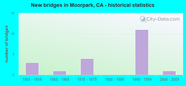
- New bridges - historical statistics
- 31950-1959
- 11960-1969
- 41970-1979
- 111990-1999
- 12000-2009

- Reconstructed bridges - Historical Statistics
- 11960-1969
- 11970-1979
- 01980-1989
- 01990-1999
- 22000-2009


- Bridge Condition - Deck
- 73.3%Good
- 20.0%Fair
- 6.7%Poor

- Bridge Condition - Superstructure
- 93.3%Good
- 6.7%Satisfactory

- Bridge Condition - Channel
- 20.0%Excellent
- 50.0%Very good
- 20.0%Good
- 10.0%Satisfactory
Find on map >> Show street view
Structure Number: 52 0113, Location: 07-VEN-023-19.82 (Lat: 34.345189, Lng: -118.905717), Route carried "on" structure: State highway 23, Year Built: 1991, Status: Open, Structure Length: 0.67m (2.20ft), Average Daily Traffic: 6,200 (year 2017), Truck Traffic: 16%, Average Future Daily Traffic: 11,447 (year 2041), Design Load: HS 20, Features Intersected: GRIMES CANYON CHANNEL
Minimum Vertical Clearance: 30+ m (98+ ft), Kilometerpoint: 19.820, Lanes on structure: 2, Base Highway Network: Yes (, Subroute: 1), Owner: State Highway Agency, Approaching Roadway Width: 14.3m (46.9ft), Skew: 2 degrees, Material/Design: Concrete continuous, Design/Construction: Culvert, Number Of Spans In Main Unit: 2, Length of Maximum Span: 3.0m (9.8ft), Curb-To-Curb Width: 14.3m (46.9ft), Out-to-Out Width: 15.4m (50.5ft)
Condition: Channel: Excellent, Culverts: Good, Operating Rating: 54.1 metric tons, Method Used To Determine Operating Rating: Field evaluation and documented engineering judgment, Inventory Rating: 32.4 metric tons, Method Used To Determine Inventory Rating: Field evaluation and documented engineering judgment, Structural Evaluation: Better than present minimum criteria, Deck Geometry: Superior to present desirable criteria, Waterway Adequacy: Meets minimum limits, Approach Roadway Alignment: High priority of corrective action, Designated Inspection Frequency: Every 24 months, Inspection Date: July 2021
Find on map >> Show street view
Structure Number: 52 0319K, Location: 07-VEN-023-R10.16-MRPK (Lat: 34.266358, Lng: -118.851331), Route carried "on" structure: Bypass State highway 23, Year Built: 1970, Status: Open, Structure Length: 5.13m (16.83ft), Average Daily Traffic: 3,500 (year 2015), Truck Traffic: 2%, Average Future Daily Traffic: 5,412 (year 2041), Design Load: HS 20, Features Intersected: TIERRA REJADA ROAD
Minimum Vertical Clearance: 30+ m (98+ ft), Kilometerpoint: 10.160, Lanes on structure: 1, Lanes under structure: 6, Base Highway Network: Yes (, Subroute: 1), Owner: State Highway Agency, Approaching Roadway Width: 7.3m (24.0ft), Material/Design: Concrete continuous, Design/Construction: Box Beam or Girders - Multiple, Number Of Spans In Main Unit: 2, Length of Maximum Span: 25.5m (83.7ft), Curb-To-Curb Width: 7.3m (24.0ft), Out-to-Out Width: 7.9m (25.9ft)
Condition: Deck: Good, Superstructure: Good, Substructure: Good, Operating Rating: 45.4 metric tons, Method Used To Determine Operating Rating: Load and Resistance Factor Rating (LRFR) rating reported by rating factor(RF) method using HL-93 loadings, Inventory Rating: 35.0 metric tons, Method Used To Determine Inventory Rating: Load and Resistance Factor Rating (LRFR) rating reported by rating factor(RF) method using HL-93 loadings, Structural Evaluation: Better than present minimum criteria, Deck Geometry: High priority of replacement, Underclear: Better than present minimum criteria, Approach Roadway Alignment: Equal to present desirable criteria, Designated Inspection Frequency: Every 48 months, Inspection Date: June 2019, Deck Structure Type: Concrete Cast-file-Place
Find on map >> Show street view
Structure Number: 52 0319L, Location: 07-VEN-023-R10.16-MRPK (Lat: 34.266489, Lng: -118.851128), Route carried "on" structure: State highway 23, Year Built: 1970, Year Reconstructed: 2008, Status: Open, Structure Length: 5.36m (17.59ft), Average Daily Traffic: 60,000 (year 2015), Truck Traffic: 13%, Average Future Daily Traffic: 97,830 (year 2041), Design Load: HS 20, Features Intersected: TIERRA REJADA ROAD
Minimum Vertical Clearance: 30+ m (98+ ft), Kilometerpoint: 10.160, Lanes on structure: 3, Lanes under structure: 5, Base Highway Network: Yes (, Subroute: 1), Owner: State Highway Agency, Approaching Roadway Width: 18.4m (60.4ft), Material/Design: Concrete continuous, Design/Construction: Box Beam or Girders - Multiple, Number Of Spans In Main Unit: 2, Length of Maximum Span: 27.7m (90.9ft), Curb-To-Curb Width: 18.4m (60.4ft), Out-to-Out Width: 19.2m (63.0ft)
Condition: Deck: Fair, Superstructure: Good, Substructure: Good, Operating Rating: 30.1 metric tons, Method Used To Determine Operating Rating: Load and Resistance Factor Rating (LRFR) rating reported by rating factor(RF) method using HL-93 loadings, Inventory Rating: 23.3 metric tons, Method Used To Determine Inventory Rating: Load and Resistance Factor Rating (LRFR) rating reported by rating factor(RF) method using HL-93 loadings, Structural Evaluation: Somewhat better than minimum adequacy, Deck Geometry: Superior to present desirable criteria, Underclear: Better than present minimum criteria, Approach Roadway Alignment: Equal to present desirable criteria, Designated Inspection Frequency: Every 24 months, Inspection Date: June 2021, Deck Structure Type: Concrete Cast-file-Place
Find on map >> Show street view
Structure Number: 52 0319R, Location: 07-VEN-023-R10.16-MRPK (Lat: 34.266708, Lng: -118.850806), Route carried "on" structure: State highway 23, Year Built: 1970, Year Reconstructed: 2008, Status: Open, Structure Length: 5.36m (17.59ft), Average Daily Traffic: 60,000 (year 2015), Truck Traffic: 13%, Average Future Daily Traffic: 97,830 (year 2041), Design Load: HS 20, Features Intersected: TIERRA REJADA ROAD
Minimum Vertical Clearance: 30+ m (98+ ft), Kilometerpoint: 10.160, Lanes on structure: 4, Lanes under structure: 5, Base Highway Network: Yes (, Subroute: 1), Owner: State Highway Agency, Approaching Roadway Width: 23.5m (77.1ft), Material/Design: Concrete continuous, Design/Construction: Box Beam or Girders - Multiple, Number Of Spans In Main Unit: 2, Length of Maximum Span: 27.7m (90.9ft), Curb-To-Curb Width: 23.5m (77.1ft), Out-to-Out Width: 24.2m (79.4ft)
Condition: Deck: Fair, Superstructure: Good, Substructure: Good, Operating Rating: 78.4 metric tons, Method Used To Determine Operating Rating: Load Factor (LF), Inventory Rating: 47.3 metric tons, Method Used To Determine Inventory Rating: Load Factor (LF), Structural Evaluation: Better than present minimum criteria, Deck Geometry: Superior to present desirable criteria, Underclear: Better than present minimum criteria, Approach Roadway Alignment: Equal to present desirable criteria, Designated Inspection Frequency: Every 24 months, Inspection Date: June 2021, Deck Structure Type: Concrete Cast-file-Place
Find on map >> Show street view
Structure Number: 52 0330R, Location: 07-VEN-023-T11.55 (Lat: 34.282106, Lng: -118.862767), Route carried "on" structure: State highway 23, Year Built: 1993, Status: Open, Structure Length: 5.94m (19.49ft), Average Daily Traffic: 72,000 (year 2019), Truck Traffic: 15%, Average Future Daily Traffic: 98,000 (year 2041), Design Load: HS 20+Mod, Features Intersected: NEW LOS ANGELES AVE
Minimum Vertical Clearance: 30+ m (98+ ft), Kilometerpoint: 11.550, Lanes on structure: 3, Lanes under structure: 4, Base Highway Network: Yes (, Subroute: 1), Owner: State Highway Agency, Approaching Roadway Width: 20.7m (67.9ft), Material/Design: Prestressed concrete continuous, Design/Construction: Box Beam or Girders - Multiple, Number Of Spans In Main Unit: 2, Length of Maximum Span: 30.4m (99.7ft), Curb-To-Curb Width: 20.7m (67.9ft), Out-to-Out Width: 22.4m (73.5ft)
Condition: Deck: Fair, Superstructure: Good, Substructure: Good, Operating Rating: 54.1 metric tons, Method Used To Determine Operating Rating: Assigned rating based on Load Factor Design (LFD) reported in metric tons, Inventory Rating: 32.4 metric tons, Method Used To Determine Inventory Rating: Assigned rating based on Load Factor Design (LFD) reported in metric tons, Structural Evaluation: Better than present minimum criteria, Deck Geometry: Superior to present desirable criteria, Underclear: High priority of corrective action, Approach Roadway Alignment: Equal to present desirable criteria, Designated Inspection Frequency: Every 24 months, Inspection Date: July 2021, Deck Structure Type: Concrete Cast-file-Place
Find on map >> Show street view
Structure Number: 52 0331L, Location: 07-VEN-118-T18.68 (Lat: 34.285022, Lng: -118.864514), Route carried "on" structure: State highway 118, Year Built: 1993, Status: Open, Structure Length: 41.45m (135.99ft), Average Daily Traffic: 41,500 (year 2019), Truck Traffic: 11%, Average Future Daily Traffic: 51,000 (year 2041), Design Load: HS 20+Mod, Features Intersected: UP RR,AMTRAK,METROLINK,
Minimum Vertical Clearance: 30+ m (98+ ft), Kilometerpoint: 18.680, Lanes on structure: 2, Lanes under structure: 2, Base Highway Network: Yes (Inventory Route: 1, Subroute: 1), Owner: State Highway Agency, Approaching Roadway Width: 13.4m (44.0ft), Skew: 9 degrees, Material/Design: Prestressed concrete continuous, Design/Construction: Box Beam or Girders - Multiple, Number Of Spans In Main Unit: 6, Length of Maximum Span: 76.2m (250.0ft), Curb-To-Curb Width: 13.4m (44.0ft), Out-to-Out Width: 14.5m (47.6ft)
Condition: Deck: Good, Superstructure: Good, Substructure: Good, Channel: Very good, Operating Rating: 54.1 metric tons, Method Used To Determine Operating Rating: Assigned rating based on Load Factor Design (LFD) reported in metric tons, Inventory Rating: 32.4 metric tons, Method Used To Determine Inventory Rating: Assigned rating based on Load Factor Design (LFD) reported in metric tons, Structural Evaluation: Better than present minimum criteria, Deck Geometry: Superior to present desirable criteria, Underclear: Meets minimum limits, Waterway Adequacy: Equal to present desirable criteria, Approach Roadway Alignment: Equal to present desirable criteria, Designated Inspection Frequency: Every 24 months, Inspection Date: January 2021, Deck Structure Type: Concrete Cast-file-Place
Find on map >> Show street view
Structure Number: 52 0331R, Location: 07-VEN-118-T18.44 (Lat: 34.285075, Lng: -118.863986), Route carried "on" structure: State highway 118, Year Built: 1993, Status: Open, Structure Length: 53.86m (176.71ft), Average Daily Traffic: 41,500 (year 2019), Truck Traffic: 11%, Average Future Daily Traffic: 51,000 (year 2041), Design Load: HS 20+Mod, Features Intersected: UP RR,AMTRAK,METROLINK,
Minimum Vertical Clearance: 30+ m (98+ ft), Kilometerpoint: 18.440, Lanes on structure: 2, Lanes under structure: 2, Base Highway Network: Yes (Inventory Route: 1, Subroute: 1), Owner: State Highway Agency, Approaching Roadway Width: 13.4m (44.0ft), Skew: 9 degrees, Material/Design: Prestressed concrete continuous, Design/Construction: Box Beam or Girders - Multiple, Number Of Spans In Main Unit: 8, Length of Maximum Span: 77.1m (253.0ft), Curb-To-Curb Width: 13.4m (44.0ft), Out-to-Out Width: 14.5m (47.6ft)
Condition: Deck: Good, Superstructure: Good, Substructure: Good, Channel: Very good, Operating Rating: 54.1 metric tons, Method Used To Determine Operating Rating: Assigned rating based on Load Factor Design (LFD) reported in metric tons, Inventory Rating: 32.4 metric tons, Method Used To Determine Inventory Rating: Assigned rating based on Load Factor Design (LFD) reported in metric tons, Structural Evaluation: Better than present minimum criteria, Deck Geometry: Superior to present desirable criteria, Underclear: Meets minimum limits, Waterway Adequacy: Equal to present desirable criteria, Approach Roadway Alignment: Equal to present desirable criteria, Designated Inspection Frequency: Every 24 months, Inspection Date: January 2021, Deck Structure Type: Concrete Cast-file-Place
Find on map >> Show street view
Structure Number: 52 0332, Location: 07-VEN-118-T20.00 (Lat: 34.293628, Lng: -118.842875), Route carried "on" structure: City street , Year Built: 1993, Status: Open, Structure Length: 7.38m (24.21ft), Average Daily Traffic: 6,000 (year 2019), Truck Traffic: 2%, Average Future Daily Traffic: 20,403 (year 2041), Design Load: HS 20+Mod, Features Intersected: ROUTE 118, Facility Carried by Structure: COLLINS DRIVE
Minimum Vertical Clearance: 30+ m (98+ ft), Kilometerpoint: 0.000, Lanes on structure: 4, Lanes under structure: 5, Owner: State Highway Agency, Approaching Roadway Width: 20.1m (65.9ft), Skew: 2 degrees, Material/Design: Prestressed concrete continuous, Design/Construction: Box Beam or Girders - Multiple, Number Of Spans In Main Unit: 2, Length of Maximum Span: 42.8m (140.4ft), Curb or Sidewalk Widths: Left: 0.0m, Right: 1.5m (4.9ft), Curb-To-Curb Width: 20.1m (65.9ft), Out-to-Out Width: 22.5m (73.8ft)
Condition: Deck: Good, Superstructure: Good, Substructure: Good, Operating Rating: 54.1 metric tons, Method Used To Determine Operating Rating: Assigned rating based on Load Factor Design (LFD) reported in metric tons, Inventory Rating: 32.4 metric tons, Method Used To Determine Inventory Rating: Assigned rating based on Load Factor Design (LFD) reported in metric tons, Structural Evaluation: Better than present minimum criteria, Deck Geometry: Better than present minimum criteria, Underclear: Equal to present minimum criteria, Approach Roadway Alignment: Equal to present desirable criteria, Designated Inspection Frequency: Every 24 months, Inspection Date: January 2021, Deck Structure Type: Concrete Cast-file-Place
Find on map >> Show street view
Structure Number: 52 0334L, Location: 07-VEN-118-T19.12 (Lat: 34.292853, Lng: -118.857731), Route carried "on" structure: State highway 118, Year Built: 1993, Status: Open, Structure Length: 4.51m (14.80ft), Average Daily Traffic: 41,500 (year 2019), Truck Traffic: 7%, Average Future Daily Traffic: 51,000 (year 2041), Design Load: HS 20+Mod, Features Intersected: PRINCETON AVENUE
Minimum Vertical Clearance: 30+ m (98+ ft), Kilometerpoint: 19.120, Lanes on structure: 2, Lanes under structure: 5, Base Highway Network: Yes (Inventory Route: 1, Subroute: 1), Owner: State Highway Agency, Approaching Roadway Width: 13.4m (44.0ft), Material/Design: Prestressed concrete, Design/Construction: Box Beam or Girders - Multiple, Number Of Spans In Main Unit: 1, Length of Maximum Span: 44.3m (145.3ft), Curb-To-Curb Width: 13.4m (44.0ft), Out-to-Out Width: 14.3m (46.9ft)
Condition: Deck: Good, Superstructure: Good, Substructure: Good, Operating Rating: 54.1 metric tons, Method Used To Determine Operating Rating: Assigned rating based on Load Factor Design (LFD) reported in metric tons, Inventory Rating: 32.4 metric tons, Method Used To Determine Inventory Rating: Assigned rating based on Load Factor Design (LFD) reported in metric tons, Structural Evaluation: Better than present minimum criteria, Deck Geometry: Superior to present desirable criteria, Underclear: Meets minimum limits, Approach Roadway Alignment: Equal to present desirable criteria, Designated Inspection Frequency: Every 24 months, Inspection Date: January 2021, Deck Structure Type: Concrete Cast-file-Place
Find on map >> Show street view
Structure Number: 52 0334R, Location: 07-VEN-118-T19.12 (Lat: 34.292297, Lng: -118.857789), Route carried "on" structure: State highway 118, Year Built: 1993, Status: Open, Structure Length: 5.33m (17.49ft), Average Daily Traffic: 41,500 (year 2019), Truck Traffic: 11%, Average Future Daily Traffic: 51,000 (year 2041), Design Load: HS 20+Mod, Features Intersected: PRINCETON AVENUE
Minimum Vertical Clearance: 30+ m (98+ ft), Kilometerpoint: 19.120, Lanes on structure: 2, Lanes under structure: 5, Base Highway Network: Yes (Inventory Route: 1, Subroute: 1), Owner: State Highway Agency, Approaching Roadway Width: 13.4m (44.0ft), Skew: 1 degrees, Material/Design: Prestressed concrete, Design/Construction: Box Beam or Girders - Multiple, Number Of Spans In Main Unit: 1, Length of Maximum Span: 52.6m (172.6ft), Curb-To-Curb Width: 13.4m (44.0ft), Out-to-Out Width: 14.5m (47.6ft)
Condition: Deck: Good, Superstructure: Good, Substructure: Good, Operating Rating: 54.1 metric tons, Method Used To Determine Operating Rating: Assigned rating based on Load Factor Design (LFD) reported in metric tons, Inventory Rating: 32.4 metric tons, Method Used To Determine Inventory Rating: Assigned rating based on Load Factor Design (LFD) reported in metric tons, Structural Evaluation: Better than present minimum criteria, Deck Geometry: Superior to present desirable criteria, Underclear: Somewhat better than minimum adequacy, Approach Roadway Alignment: Equal to present desirable criteria, Designated Inspection Frequency: Every 24 months, Inspection Date: January 2021, Deck Structure Type: Concrete Cast-file-Place
Find on map >> Show street view
Structure Number: 52 0368, Location: 07-VEN-023-R9.84 (Lat: 34.262728, Lng: -118.847364), Route carried "on" structure: State highway 23, Year Built: 1970, Status: Open, Structure Length: 1.10m (3.61ft), Average Daily Traffic: 60,000 (year 2015), Truck Traffic: 13%, Average Future Daily Traffic: 97,830 (year 2041), Design Load: HS 20, Features Intersected: TIERRA REJADA CHANNEL
Minimum Vertical Clearance: 30+ m (98+ ft), Kilometerpoint: 9.840, Lanes on structure: 7, Base Highway Network: Yes (, Subroute: 1), Owner: State Highway Agency, Approaching Roadway Width: 40.0m (131.2ft), Skew: 33 degrees, Material/Design: Concrete, Design/Construction: Culvert, Number Of Spans In Main Unit: 3, Length of Maximum Span: 3.0m (9.8ft)
Condition: Channel: Good, Culverts: Good, Operating Rating: 54.1 metric tons, Method Used To Determine Operating Rating: Field evaluation and documented engineering judgment, Inventory Rating: 32.4 metric tons, Method Used To Determine Inventory Rating: Field evaluation and documented engineering judgment, Structural Evaluation: Better than present minimum criteria, Waterway Adequacy: Equal to present desirable criteria, Approach Roadway Alignment: Equal to present desirable criteria, Length Of Structure Improvement: 1.10m (3.61ft), Designated Inspection Frequency: Every 24 months, Inspection Date: June 2021
Find on map >> Show street view
Structure Number: 52C0033, Location: 0.3 MI S OF ST RTE 118 (Lat: 34.271375, Lng: -118.924417), Route carried "on" structure: County highway , Year Built: 1950, Year Reconstructed: 1968, Status: Open, Structure Length: 5.03m (16.50ft), Average Daily Traffic: 3,100 (year 2019), Truck Traffic: 1%, Average Future Daily Traffic: 4,163 (year 2038), Design Load: HS 20, Features Intersected: ARROYO LAS POSAS, Facility Carried by Structure: HITCH BLVD
Minimum Vertical Clearance: 30+ m (98+ ft), Kilometerpoint: 0.000, Lanes on structure: 2, Owner: County Highway Agency, Approaching Roadway Width: 6.7m (22.0ft), Skew: 3 degrees, Material/Design: Steel continuous, Design/Construction: Stringer/Multi-beam, Number Of Spans In Main Unit: 5, Length of Maximum Span: 11.9m (39.0ft), Curb-To-Curb Width: 9.6m (31.5ft), Out-to-Out Width: 9.8m (32.2ft)
Condition: Deck: Good, Superstructure: Good, Substructure: Good, Channel: Excellent, Operating Rating: 48.3 metric tons, Method Used To Determine Operating Rating: Load Factor (LF), Inventory Rating: 35.0 metric tons, Method Used To Determine Inventory Rating: Load Factor (LF), Structural Evaluation: Better than present minimum criteria, Deck Geometry: Meets minimum limits, Waterway Adequacy: Superior to present desirable criteria, Approach Roadway Alignment: Equal to present desirable criteria, Designated Inspection Frequency: Every 48 months, Inspection Date: December 2020, Deck Structure Type: Concrete Cast-file-Place
Find on map >> Show street view
Structure Number: 52C0176, Location: 1.4 MI N OF S.R. 118 (Lat: 34.290053, Lng: -118.929997), Route carried "on" structure: County highway , Year Built: 1967, Status: Open, Structure Length: 2.23m (7.32ft), Average Daily Traffic: 3,100 (year 2019), Truck Traffic: 3%, Average Future Daily Traffic: 5,222 (year 2038), Design Load: HS 20, Features Intersected: GRIMES CANYON WASH, Facility Carried by Structure: GRIMES CANYON RD
Minimum Vertical Clearance: 30+ m (98+ ft), Kilometerpoint: 0.000, Lanes on structure: 2, Owner: County Highway Agency, Approaching Roadway Width: 6.4m (21.0ft), Skew: 6 degrees, Material/Design: Steel, Design/Construction: Stringer/Multi-beam, Number Of Spans In Main Unit: 1, Length of Maximum Span: 19.8m (65.0ft), Curb-To-Curb Width: 12.0m (39.4ft), Out-to-Out Width: 12.2m (40.0ft)
Condition: Deck: Good, Superstructure: Good, Substructure: Good, Channel: Very good, Operating Rating: 57.3 metric tons, Method Used To Determine Operating Rating: Load Factor (LF), Inventory Rating: 34.3 metric tons, Method Used To Determine Inventory Rating: Load Factor (LF), Structural Evaluation: Better than present minimum criteria, Deck Geometry: Somewhat better than minimum adequacy, Waterway Adequacy: Equal to present minimum criteria, Approach Roadway Alignment: Equal to present desirable criteria, Designated Inspection Frequency: Every 24 months, Other Special Inspection Frequency: Every 48 months, Inspection Date: August 2020, Other Special Inspection Date: August 2020, Deck Structure Type: Concrete Cast-file-Place
Find on map >> Show street view
Structure Number: 52C0177, Location: 1.8 MI N OF S.R. 118 (Lat: 34.293036, Lng: -118.923911), Route carried "on" structure: County highway , Year Built: 1954, Status: Open, Structure Length: 1.55m (5.09ft), Average Daily Traffic: 3,100 (year 2019), Truck Traffic: 3%, Average Future Daily Traffic: 5,222 (year 2038), Features Intersected: GRIMES CANYON WASH, Facility Carried by Structure: GRIMES CANYON RD
Minimum Vertical Clearance: 30+ m (98+ ft), Kilometerpoint: 0.000, Lanes on structure: 2, Owner: County Highway Agency, Approaching Roadway Width: 6.4m (21.0ft), Skew: 5 degrees, Material/Design: Steel continuous, Design/Construction: Stringer/Multi-beam, Number Of Spans In Main Unit: 2, Length of Maximum Span: 8.5m (27.9ft), Curb or Sidewalk Widths: Left: 0.5m (1.6ft), Right: 0.5m (1.6ft), Curb-To-Curb Width: 6.1m (20.0ft), Out-to-Out Width: 7.0m (23.0ft)
Condition: Deck: Good, Superstructure: Good, Substructure: Good, Channel: Good, Operating Rating: 84.6 metric tons, Method Used To Determine Operating Rating: Load Factor (LF), Inventory Rating: 50.9 metric tons, Method Used To Determine Inventory Rating: Load Factor (LF), Structural Evaluation: Better than present minimum criteria, Deck Geometry: High priority of replacement, Waterway Adequacy: Equal to present minimum criteria, Approach Roadway Alignment: Equal to present desirable criteria, Designated Inspection Frequency: Every 24 months, Inspection Date: August 2020, Deck Structure Type: Concrete Cast-file-Place, Wearing Surface/Protective System: Wearing Surface: Bituminous
Find on map >> Show street view
Structure Number: 52C0178, Location: 0.3 MI W GRIMES CYN RD (Lat: 34.315147, Lng: -118.913750), Route carried "on" structure: County highway , Year Built: 1950, Year Reconstructed: 1976, Status: Open, Structure Length: 0.98m (3.22ft), Average Daily Traffic: 2,400 (year 2019), Truck Traffic: 2%, Average Future Daily Traffic: 5,204 (year 2038), Features Intersected: SHEKELL WASH, Facility Carried by Structure: BROADWAY RD
Minimum Vertical Clearance: 30+ m (98+ ft), Kilometerpoint: 0.000, Lanes on structure: 2, Owner: County Highway Agency, Approaching Roadway Width: 6.4m (21.0ft), Material/Design: Steel continuous, Design/Construction: Stringer/Multi-beam, Number Of Spans In Main Unit: 2, Length of Maximum Span: 4.9m (16.1ft), Curb or Sidewalk Widths: Left: 0.2m (0.7ft), Right: 0.2m (0.7ft), Curb-To-Curb Width: 7.3m (24.0ft), Out-to-Out Width: 7.8m (25.6ft)
Condition: Deck: Good, Superstructure: Satisfactory, Substructure: Good, Channel: Very good, Operating Rating: 99.8 metric tons, Method Used To Determine Operating Rating: Load Factor (LF), Inventory Rating: 64.2 metric tons, Method Used To Determine Inventory Rating: Load Factor (LF), Structural Evaluation: Equal to present minimum criteria, Deck Geometry: High priority of replacement, Waterway Adequacy: Equal to present desirable criteria, Approach Roadway Alignment: Equal to present desirable criteria, Designated Inspection Frequency: Every 48 months, Inspection Date: Febuary 2019, Deck Structure Type: Concrete Cast-file-Place, Wearing Surface/Protective System: Wearing Surface: Bituminous
Find on map >> Show street view
Structure Number: 52C0276, Location: .15 MI S NEW L.A. AVE (Lat: 34.276831, Lng: -118.874639), Route carried "on" structure: City street , Year Built: 1999, Status: Open, Structure Length: 4.57m (14.99ft), Average Daily Traffic: 11,000 (year 2019), Truck Traffic: 1%, Average Future Daily Traffic: 13,620 (year 2038), Design Load: HS 20+Mod, Features Intersected: ARROYO LAS POSAS, Facility Carried by Structure: SPRING RD.
Minimum Vertical Clearance: 30+ m (98+ ft), Kilometerpoint: 0.000, Lanes on structure: 2, Owner: City or Municipal Highway Agency, Approaching Roadway Width: 10.2m (33.5ft), Skew: 22 degrees, Material/Design: Prestressed concrete continuous, Design/Construction: Box Beam or Girders - Multiple, Number Of Spans In Main Unit: 2, Length of Maximum Span: 22.1m (72.5ft), Curb or Sidewalk Widths: Left: 1.5m (4.9ft), Right: 1.5m (4.9ft), Curb-To-Curb Width: 10.2m (33.5ft), Out-to-Out Width: 15.2m (49.9ft)
Condition: Deck: Poor, Superstructure: Good, Substructure: Good, Channel: Very good, Operating Rating: 54.1 metric tons, Method Used To Determine Operating Rating: Assigned rating based on Load Factor Design (LFD) reported in metric tons, Inventory Rating: 32.4 metric tons, Method Used To Determine Inventory Rating: Assigned rating based on Load Factor Design (LFD) reported in metric tons, Structural Evaluation: Better than present minimum criteria, Deck Geometry: Meets minimum limits, Waterway Adequacy: Equal to present desirable criteria, Approach Roadway Alignment: Equal to present desirable criteria, Designated Inspection Frequency: Every 24 months, Inspection Date: November 2020, Deck Structure Type: Concrete Cast-file-Place
Find on map >> Show street view
Structure Number: 52C0282, Location: 2.4 MI N/ STATE ROUTE 118 (Lat: 34.299342, Lng: -118.914578), Route carried "on" structure: County highway , Year Built: 2008, Status: Open, Structure Length: 1.83m (6.00ft), Average Daily Traffic: 3,200 (year 2019), Truck Traffic: 3%, Average Future Daily Traffic: 3,864 (year 2038), Design Load: HS 20+Mod, Features Intersected: GRIMES CANYON WASH, Facility Carried by Structure: GRIMES CANYON ROAD
Minimum Vertical Clearance: 30+ m (98+ ft), Kilometerpoint: 0.000, Lanes on structure: 2, Owner: County Highway Agency, Approaching Roadway Width: 12.2m (40.0ft), Skew: 4 degrees, Material/Design: Concrete, Design/Construction: Stringer/Multi-beam, Number Of Spans In Main Unit: 1, Length of Maximum Span: 17.5m (57.4ft), Curb-To-Curb Width: 12.2m (40.0ft), Out-to-Out Width: 13.1m (43.0ft)
Condition: Deck: Good, Superstructure: Good, Substructure: Good, Channel: Satisfactory, Operating Rating: 54.1 metric tons, Method Used To Determine Operating Rating: Assigned rating based on Load Factor Design (LFD) reported in metric tons, Inventory Rating: 32.4 metric tons, Method Used To Determine Inventory Rating: Assigned rating based on Load Factor Design (LFD) reported in metric tons, Structural Evaluation: Better than present minimum criteria, Deck Geometry: Equal to present minimum criteria, Waterway Adequacy: Equal to present minimum criteria, Approach Roadway Alignment: Equal to present minimum criteria, Designated Inspection Frequency: Every 48 months, Inspection Date: March 2019, Deck Structure Type: Concrete Cast-file-Place
Find on map >> Show street view
Structure Number: 52 0330L, Location: 07-VEN-023-T11.57 (Lat: 34.281919, Lng: -118.863194), Route carried "under" structure: State highway 23, Year Built: 1993, Structure Length: 0. m, Average Daily Traffic: 8,500 (year 2019), Truck Traffic: 7%, Features Intersected: NEW LOS ANGELES AVE
Minimum Vertical Clearance: 6.90m (22.64ft), Kilometerpoint: 11.570, Lanes on structure: 2, Lanes under structure: 4, Material/Design: Prestressed concrete continuous, Design/Construction: Box Beam or Girders - Multiple, Length of Maximum Span: 30.1m (98.8ft)
Find on map >> Show street view
Structure Number: 52 0330R, Location: 07-VEN-023-T11.55 (Lat: 34.282106, Lng: -118.862767), Route carried "under" structure: State highway 23, Year Built: 1993, Structure Length: 0. m, Average Daily Traffic: 28,346 (year 2019), Truck Traffic: 7%, Features Intersected: NEW LOS ANGELES AVE
Minimum Vertical Clearance: 6.83m (22.41ft), Kilometerpoint: 11.550, Lanes on structure: 3, Lanes under structure: 4, Material/Design: Prestressed concrete continuous, Design/Construction: Box Beam or Girders - Multiple, Length of Maximum Span: 30.4m (99.7ft)
Find on map >> Show street view
Structure Number: 52 0332, Location: 07-VEN-118-T20.00 (Lat: 34.293628, Lng: -118.842875), Route carried "under" structure: State highway 118, Year Built: 1993, Structure Length: 0. m, Average Daily Traffic: 83,000 (year 2019), Truck Traffic: 11%, Features Intersected: ROUTE 118, Facility Carried by Structure: COLLINS DRIVE
Minimum Vertical Clearance: 6.20m (20.34ft), Kilometerpoint: 20.000, Lanes on structure: 4, Lanes under structure: 5, Material/Design: Prestressed concrete continuous, Design/Construction: Box Beam or Girders - Multiple, Length of Maximum Span: 42.8m (140.4ft)