Bridge Statistics for Mount Prospect, Illinois (IL)
Condition, Traffic, Stress, Structural Evaluation, Project Costs
- National Bridge Inventory (NBI) Statistics
- 23Number of bridges
- 180ft / 54.9mTotal length
- 702,375Total average daily traffic
- 61,390Total average daily truck traffic
- National Bridge Inventory (NBI) Registered Bridges for Mount Prospect
- No street view available for this location
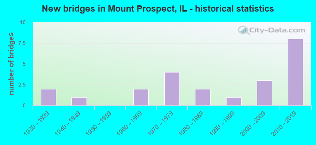
- New bridges - historical statistics
- 21930-1939
- 11940-1949
- 21960-1969
- 41970-1979
- 21980-1989
- 11990-1999
- 32000-2009
- 82010-2019

- Reconstructed bridges - Historical Statistics
- 11960-1969
- 01970-1979
- 01980-1989
- 01990-1999
- 12000-2009


- Bridge Condition - Deck
- 16.7%Very good
- 25.0%Good
- 50.0%Satisfactory
- 8.3%Fair

- Bridge Condition - Superstructure
- 41.7%Very good
- 25.0%Good
- 8.3%Satisfactory
- 25.0%Fair

- Bridge Condition - Substructure
- 58.3%Very good
- 33.3%Good
- 8.3%Satisfactory

- Bridge Condition - Channel
- 6.7%Excellent
- 13.3%Very good
- 46.7%Good
- 13.3%Satisfactory
- 20.0%Fair

- Bridge Condition - Culverts
- 28.6%Good
- 42.9%Satisfactory
- 28.6%Fair
Find on map >> Show street view
Structure Number: 160964, Location: 3.7 M S IL 68 (Lat: 42.088194, Lng: -87.907694), Route carried "on" structure: Other road , Year Built: 1932, Year Reconstructed: 1973, Status: Open, Structure Length: 2.68m (8.79ft), Average Daily Traffic: 14,100 (year 2018), Truck Traffic: 5%, Average Future Daily Traffic: 17,613 (year 2032), Design Load: HS 15, Features Intersected: MCDONALD CREEK, Facility Carried by Structure: WOLF RD
Minimum Vertical Clearance: 30+ m (98+ ft), Kilometerpoint: 7.322, Lanes on structure: 5, Base Highway Network: Yes, Owner: State Highway Agency, Approaching Roadway Width: 12.8m (42.0ft), Skew: 23 degrees, Material/Design: Concrete continuous, Design/Construction: Culvert, Number Of Spans In Main Unit: 4, Length of Maximum Span: 6.1m (20.0ft), Curb or Sidewalk Widths: Left: 4.6m (15.1ft), Right: 4.6m (15.1ft)
Condition: Channel: Fair, Culverts: Fair, Operating Rating: 52.8 metric tons, Method Used To Determine Operating Rating: Load Factor (LF) rating reported by rating factor (RF) method using MS18 loading, Inventory Rating: 31.4 metric tons, Method Used To Determine Inventory Rating: Load Factor (LF) rating reported by rating factor (RF) method using MS18 loading, Structural Evaluation: Somewhat better than minimum adequacy, Waterway Adequacy: Equal to present desirable criteria, Approach Roadway Alignment: Equal to present desirable criteria, Designated Inspection Frequency: Every 24 months, Inspection Date: August 2021
Find on map >> Show street view
Structure Number: 162418, Location: 1.8 N OF IL 58 (Lat: 42.077708, Lng: -87.892942), Route carried "on" structure: US 45, Year Built: 1984, Status: Open, Structure Length: 2.00m (6.56ft), Average Daily Traffic: 18,100 (year 2021), Truck Traffic: 6%, Average Future Daily Traffic: 22,660 (year 2032), Design Load: HS 20, Features Intersected: MCDONALD CREEK
Minimum Vertical Clearance: 30+ m (98+ ft), Kilometerpoint: 633.581, Lanes on structure: 4, Base Highway Network: Yes, Owner: State Highway Agency, Approaching Roadway Width: 15.8m (51.8ft), Material/Design: Concrete continuous, Design/Construction: Slab, Number Of Spans In Main Unit: 3, Length of Maximum Span: 7.0m (23.0ft), Curb or Sidewalk Widths: Left: 1.5m (4.9ft), Right: 1.5m (4.9ft), Curb-To-Curb Width: 15.8m (51.8ft), Out-to-Out Width: 19.7m (64.6ft)
Condition: Deck: Satisfactory, Superstructure: Fair, Substructure: Good, Channel: Good, Operating Rating: 61.2 metric tons, Method Used To Determine Operating Rating: Load Factor (LF) rating reported by rating factor (RF) method using MS18 loading, Inventory Rating: 36.6 metric tons, Method Used To Determine Inventory Rating: Load Factor (LF) rating reported by rating factor (RF) method using MS18 loading, Structural Evaluation: Somewhat better than minimum adequacy, Deck Geometry: Meets minimum limits, Waterway Adequacy: Equal to present desirable criteria, Approach Roadway Alignment: Equal to present desirable criteria, Designated Inspection Frequency: Every 24 months, Inspection Date: July 2021, Deck Structure Type: Concrete Cast-file-Place, Wearing Surface/Protective System: Deck Protection: Epoxy Coated Reinforcing
Find on map >> Show street view
Structure Number: 1625, Location: 0.4 M W ELMHURST RD (Lat: 42.022594, Lng: -87.948636), Route carried "on" structure: State highway 83, Year Built: 1972, Status: Open, Structure Length: 1.52m (4.99ft), Average Daily Traffic: 20,500 (year 2021), Truck Traffic: 13%, Average Future Daily Traffic: 24,102 (year 2032), Design Load: HS 20, Features Intersected: HIGGINS CREEK
Minimum Vertical Clearance: 30+ m (98+ ft), Kilometerpoint: 88.785, Lanes on structure: 4, Base Highway Network: Yes, Owner: State Highway Agency, Approaching Roadway Width: 20.7m (67.9ft), Skew: 24 degrees, Material/Design: Concrete continuous, Design/Construction: Culvert, Number Of Spans In Main Unit: 2, Length of Maximum Span: 7.0m (23.0ft), Out-to-Out Width: 40.2m (131.9ft)
Condition: Channel: Good, Culverts: Good, Operating Rating: 95.3 metric tons, Method Used To Determine Operating Rating: Load Factor (LF) rating reported by rating factor (RF) method using MS18 loading, Inventory Rating: 57.0 metric tons, Method Used To Determine Inventory Rating: Load Factor (LF) rating reported by rating factor (RF) method using MS18 loading, Structural Evaluation: Better than present minimum criteria, Waterway Adequacy: Equal to present minimum criteria, Approach Roadway Alignment: Equal to present desirable criteria, Designated Inspection Frequency: Every 48 months, Inspection Date: July 2018
Find on map >> Show street view
Structure Number: 162515, Location: 0.05 M W RIVER RD (Lat: 42.080489, Lng: -87.893594), Route carried "on" structure: Other road , Year Built: 1938, Status: Open, Structure Length: 1.46m (4.79ft), Average Daily Traffic: 4,950 (year 2021), Truck Traffic: 3%, Average Future Daily Traffic: 8,137 (year 2032), Features Intersected: MC DONALD CREEK, Facility Carried by Structure: KENSINGTON RD
Minimum Vertical Clearance: 30+ m (98+ ft), Kilometerpoint: 6.807, Lanes on structure: 2, Owner: State Highway Agency, Approaching Roadway Width: 10.7m (35.1ft), Material/Design: Concrete continuous, Design/Construction: Culvert, Number Of Spans In Main Unit: 3, Length of Maximum Span: 4.9m (16.1ft), Curb-To-Curb Width: 10.7m (35.1ft), Out-to-Out Width: 12.9m (42.3ft)
Condition: Channel: Fair, Culverts: Fair, Operating Rating: 63.8 metric tons, Method Used To Determine Operating Rating: Load Factor (LF) rating reported by rating factor (RF) method using MS18 loading, Inventory Rating: 38.2 metric tons, Method Used To Determine Inventory Rating: Load Factor (LF) rating reported by rating factor (RF) method using MS18 loading, Structural Evaluation: Somewhat better than minimum adequacy, Deck Geometry: Somewhat better than minimum adequacy, Waterway Adequacy: Better than present minimum criteria, Approach Roadway Alignment: Equal to present desirable criteria, Designated Inspection Frequency: Every 24 months, Inspection Date: June 2021, Deck Structure Type: Other
Find on map >> Show street view
Structure Number: 162552, Location: 0.68M.N.OF CENTRAL (Lat: 42.075019, Lng: -87.907711), Route carried "on" structure: Other road , Year Built: 1991, Status: Open, Structure Length: 0.91m (2.99ft), Average Daily Traffic: 12,500 (year 2021), Truck Traffic: 6%, Average Future Daily Traffic: 17,613 (year 2032), Design Load: HS 20, Features Intersected: FEEHANVILLE DITCH, Facility Carried by Structure: WOLF RD.
Minimum Vertical Clearance: 30+ m (98+ ft), Kilometerpoint: 8.755, Lanes on structure: 4, Base Highway Network: Yes, Owner: City or Municipal Highway Agency, Approaching Roadway Width: 19.7m (64.6ft), Skew: 4 degrees, Material/Design: Concrete, Design/Construction: Culvert, Number Of Spans In Main Unit: 2, Length of Maximum Span: 4.1m (13.5ft), Curb or Sidewalk Widths: Left: 1.5m (4.9ft), Right: 1.5m (4.9ft)
Condition: Channel: Satisfactory, Culverts: Satisfactory, Operating Rating: 46.7 metric tons, Method Used To Determine Operating Rating: Load Factor (LF) rating reported by rating factor (RF) method using MS18 loading, Inventory Rating: 28.2 metric tons, Method Used To Determine Inventory Rating: Load Factor (LF) rating reported by rating factor (RF) method using MS18 loading, Structural Evaluation: Equal to present minimum criteria, Waterway Adequacy: Equal to present desirable criteria, Approach Roadway Alignment: Equal to present desirable criteria, Designated Inspection Frequency: Every 24 months, Inspection Date: August 2020, Deck Structure Type: Other, Wearing Surface/Protective System: Wearing Surface: Integral Concrete
Find on map >> Show street view
Structure Number: 162666, Location: 0.8 M S US 14 (Lat: 42.055247, Lng: -87.940825), Route carried "on" structure: State highway 83, Year Built: 2000, Status: Open, Structure Length: 1.98m (6.50ft), Average Daily Traffic: 11,900 (year 2021), Truck Traffic: 5%, Average Future Daily Traffic: 16,274 (year 2032), Features Intersected: WELLER'S CREEK
Minimum Vertical Clearance: 30+ m (98+ ft), Kilometerpoint: 93.050, Lanes on structure: 4, Base Highway Network: Yes, Owner: State Highway Agency, Approaching Roadway Width: 18.3m (60.0ft), Skew: 1 degrees, Material/Design: Steel, Design/Construction: Stringer/Multi-beam, Number Of Spans In Main Unit: 1, Length of Maximum Span: 19.1m (62.7ft), Curb or Sidewalk Widths: Left: 2.1m (6.9ft), Right: 2.1m (6.9ft), Curb-To-Curb Width: 15.2m (49.9ft), Out-to-Out Width: 20.0m (65.6ft)
Condition: Deck: Satisfactory, Superstructure: Good, Substructure: Good, Channel: Very good, Operating Rating: 64.5 metric tons, Method Used To Determine Operating Rating: Load Factor (LF) rating reported by rating factor (RF) method using MS18 loading, Inventory Rating: 38.6 metric tons, Method Used To Determine Inventory Rating: Load Factor (LF) rating reported by rating factor (RF) method using MS18 loading, Structural Evaluation: Better than present minimum criteria, Deck Geometry: High priority of corrective action, Waterway Adequacy: Equal to present desirable criteria, Approach Roadway Alignment: Equal to present desirable criteria, Designated Inspection Frequency: Every 48 months, Inspection Date: September 2018, Deck Structure Type: Concrete Cast-file-Place, Wearing Surface/Protective System: Deck Protection: Epoxy Coated Reinforcing
Find on map >> Show street view
Structure Number: 16325, Location: .15M E.OFUS45 (Lat: 42.087231, Lng: -87.888556), Route carried "on" structure: Other road , Year Built: 2001, Status: Open, Structure Length: 0.72m (2.36ft), Average Daily Traffic: 20,400 (year 2018), Truck Traffic: 4%, Average Future Daily Traffic: 22,969 (year 2032), Design Load: HS 20, Features Intersected: DESPLAINES R SLOUGH, Facility Carried by Structure: WEST LAKE AV
Minimum Vertical Clearance: 30+ m (98+ ft), Kilometerpoint: 14.468, Lanes on structure: 4, Base Highway Network: Yes, Owner: County Highway Agency, Approaching Roadway Width: 16.2m (53.1ft), Skew: 30 degrees, Material/Design: Concrete continuous, Design/Construction: Culvert, Number Of Spans In Main Unit: 2, Length of Maximum Span: 3.5m (11.5ft), Curb or Sidewalk Widths: Left: 3.1m (10.2ft), Right: 1.6m (5.2ft), Curb-To-Curb Width: 16.2m (53.1ft), Out-to-Out Width: 16.5m (54.1ft)
Condition: Channel: Fair, Culverts: Good, Operating Rating: 44.1 metric tons, Method Used To Determine Operating Rating: Assigned rating based on Load Factor Design (LFD) reported by rating factor (RF) using MS18 loading, Inventory Rating: 32.4 metric tons, Method Used To Determine Inventory Rating: Assigned rating based on Load Factor Design (LFD) reported by rating factor (RF) using MS18 loading, Structural Evaluation: Better than present minimum criteria, Deck Geometry: Meets minimum limits, Waterway Adequacy: Superior to present desirable criteria, Approach Roadway Alignment: Equal to present desirable criteria, Designated Inspection Frequency: Every 48 months, Inspection Date: October 2020
Find on map >> Show street view
Structure Number: 163251, Location: .2M E. OF US45 (Lat: 42.087400, Lng: -87.887356), Route carried "on" structure: Other road , Year Built: 2001, Status: Open, Structure Length: 6.38m (20.93ft), Average Daily Traffic: 20,400 (year 2018), Truck Traffic: 4%, Average Future Daily Traffic: 22,969 (year 2032), Design Load: HS 20, Features Intersected: DESPLAINES RIVER, Facility Carried by Structure: WEST LAKE AV
Minimum Vertical Clearance: 30+ m (98+ ft), Kilometerpoint: 14.564, Lanes on structure: 4, Base Highway Network: Yes, Owner: County Highway Agency, Approaching Roadway Width: 16.2m (53.1ft), Skew: 30 degrees, Material/Design: Prestressed concrete continuous, Design/Construction: Stringer/Multi-beam, Number Of Spans In Main Unit: 2, Length of Maximum Span: 30.9m (101.4ft), Curb or Sidewalk Widths: Left: 2.9m (9.5ft), Right: 1.3m (4.3ft), Curb-To-Curb Width: 16.2m (53.1ft), Out-to-Out Width: 21.9m (71.9ft)
Condition: Deck: Good, Superstructure: Very good, Substructure: Very good, Channel: Good, Operating Rating: 44.1 metric tons, Method Used To Determine Operating Rating: Assigned rating based on Load Factor Design (LFD) reported by rating factor (RF) using MS18 loading, Inventory Rating: 32.4 metric tons, Method Used To Determine Inventory Rating: Assigned rating based on Load Factor Design (LFD) reported by rating factor (RF) using MS18 loading, Structural Evaluation: Equal to present desirable criteria, Deck Geometry: Meets minimum limits, Waterway Adequacy: Superior to present desirable criteria, Approach Roadway Alignment: Equal to present desirable criteria, Designated Inspection Frequency: Every 24 months, Underwater Inspection Frequency: Every 60 months, Inspection Date: August 2020, Underwater Inspection Date: August 2020, Deck Structure Type: Concrete Cast-file-Place, Wearing Surface/Protective System: Deck Protection: Epoxy Coated Reinforcing
Find on map >> Show street view
Structure Number: 164003, Location: 0.16 M E BUSSE RDP5 (Lat: 42.059069, Lng: -87.956808), Route carried "on" structure: City street , Year Built: 1947, Year Reconstructed: 2005, Status: Posted for load, Structure Length: 1.17m (3.84ft), Average Daily Traffic: 2,500 (year 2018), Truck Traffic: 7%, Average Future Daily Traffic: 550 (year 2032), Design Load: H 20, Features Intersected: WELLER'S DRN DTCH, Facility Carried by Structure: MS-3000 (LINCOLN S
Minimum Vertical Clearance: 30+ m (98+ ft), Kilometerpoint: 1.545, Lanes on structure: 2, Owner: City or Municipal Highway Agency, Approaching Roadway Width: 11.4m (37.4ft), Skew: 2 degrees, Material/Design: Concrete, Design/Construction: Tee Beam, Number Of Spans In Main Unit: 1, Length of Maximum Span: 11.2m (36.7ft), Curb or Sidewalk Widths: Left: 1.9m (6.2ft), Right: 2.9m (9.5ft), Curb-To-Curb Width: 11.4m (37.4ft), Out-to-Out Width: 17.4m (57.1ft)
Condition: Deck: Satisfactory, Superstructure: Good, Substructure: Very good, Channel: Very good, Operating Rating: 37.6 metric tons, Method Used To Determine Operating Rating: Load Factor (LF) rating reported by rating factor (RF) method using MS18 loading, Inventory Rating: 22.4 metric tons, Method Used To Determine Inventory Rating: Load Factor (LF) rating reported by rating factor (RF) method using MS18 loading, Structural Evaluation: Somewhat better than minimum adequacy, Deck Geometry: Somewhat better than minimum adequacy, Waterway Adequacy: Superior to present desirable criteria, Approach Roadway Alignment: Equal to present desirable criteria, Bridge Posting: Required (Relationship of Operating Rating to Maximum Legal Load: 30.0 - 39.9% below), Designated Inspection Frequency: Every 24 months, Inspection Date: August 2020, Deck Structure Type: Concrete Cast-file-Place, Wearing Surface/Protective System: Wearing Surface: Latex Concrete, Deck Protection: Epoxy Coated Reinforcing
Find on map >> Show street view
Structure Number: 167535, Location: 0.24 M N ILL 58 P5 (Lat: 42.056000, Lng: -87.928631), Route carried "on" structure: City street , Year Built: 1972, Status: Open, Structure Length: 1.46m (4.79ft), Average Daily Traffic: 900 (year 2018), Truck Traffic: 10%, Average Future Daily Traffic: 1,600 (year 2040), Design Load: HS 20, Features Intersected: WELLER CR, Facility Carried by Structure: WILLIAM ST
Minimum Vertical Clearance: 30+ m (98+ ft), Kilometerpoint: 0.370, Lanes on structure: 2, Owner: City or Municipal Highway Agency, Approaching Roadway Width: 8.8m (28.9ft), Material/Design: Prestressed concrete, Design/Construction: Box Beam or Girders - Multiple, Number Of Spans In Main Unit: 1, Length of Maximum Span: 14.3m (46.9ft), Curb or Sidewalk Widths: Left: 1.4m (4.6ft), Right: 1.4m (4.6ft), Curb-To-Curb Width: 9.0m (29.5ft), Out-to-Out Width: 12.6m (41.3ft)
Condition: Deck: Satisfactory, Superstructure: Good, Substructure: Satisfactory, Channel: Good, Operating Rating: 55.7 metric tons, Method Used To Determine Operating Rating: Load Factor (LF) rating reported by rating factor (RF) method using MS18 loading, Inventory Rating: 33.0 metric tons, Method Used To Determine Inventory Rating: Load Factor (LF) rating reported by rating factor (RF) method using MS18 loading, Structural Evaluation: Equal to present minimum criteria, Deck Geometry: Somewhat better than minimum adequacy, Waterway Adequacy: Equal to present desirable criteria, Approach Roadway Alignment: Equal to present desirable criteria, Designated Inspection Frequency: Every 24 months, Inspection Date: October 2021, Deck Structure Type: Concrete Precast Panels, Wearing Surface/Protective System: Wearing Surface: Latex Concrete, Deck Protection: Epoxy Coated Reinforcing
Find on map >> Show street view
Structure Number: 167536, Location: 0.24 M N ILL 58 P5 (Lat: 42.053025, Lng: -87.925031), Route carried "on" structure: City street , Year Built: 1970, Status: Open, Structure Length: 1.28m (4.20ft), Average Daily Traffic: 425 (year 2018), Truck Traffic: 24%, Average Future Daily Traffic: 620 (year 2040), Design Load: HS 20, Features Intersected: WELLER CR, Facility Carried by Structure: GEORGE ST
Minimum Vertical Clearance: 30+ m (98+ ft), Kilometerpoint: 0.515, Lanes on structure: 2, Owner: City or Municipal Highway Agency, Approaching Roadway Width: 8.5m (27.9ft), Material/Design: Concrete, Design/Construction: Tee Beam, Number Of Spans In Main Unit: 1, Length of Maximum Span: 12.5m (41.0ft), Curb or Sidewalk Widths: Left: 1.4m (4.6ft), Right: 1.4m (4.6ft), Curb-To-Curb Width: 8.7m (28.5ft), Out-to-Out Width: 12.3m (40.4ft)
Condition: Deck: Satisfactory, Superstructure: Satisfactory, Substructure: Good, Channel: Excellent, Operating Rating: 45.4 metric tons, Method Used To Determine Operating Rating: Load Factor (LF) rating reported by rating factor (RF) method using MS18 loading, Inventory Rating: 15.2 metric tons, Method Used To Determine Inventory Rating: Load Factor (LF) rating reported by rating factor (RF) method using MS18 loading, Structural Evaluation: Meets minimum limits, Deck Geometry: Somewhat better than minimum adequacy, Waterway Adequacy: Better than present minimum criteria, Approach Roadway Alignment: Equal to present desirable criteria, Designated Inspection Frequency: Every 24 months, Inspection Date: October 2021, Deck Structure Type: Concrete Precast Panels, Wearing Surface/Protective System: Wearing Surface: Latex Concrete, Deck Protection: Epoxy Coated Reinforcing
Find on map >> Show street view
Structure Number: 167537, Location: 0.5 M N ILL 58 P5 (Lat: 42.053975, Lng: -87.949233), Route carried "on" structure: City street , Year Built: 1970, Status: Open, Structure Length: 1.34m (4.40ft), Average Daily Traffic: 1,150 (year 2018), Truck Traffic: 9%, Average Future Daily Traffic: 1,900 (year 2040), Design Load: HS 20, Features Intersected: WELLER CR, Facility Carried by Structure: SEE GWUN AVE
Minimum Vertical Clearance: 30+ m (98+ ft), Kilometerpoint: 0.531, Lanes on structure: 2, Owner: City or Municipal Highway Agency, Approaching Roadway Width: 7.9m (25.9ft), Skew: 1 degrees, Material/Design: Concrete, Design/Construction: Channel Beam, Number Of Spans In Main Unit: 1, Length of Maximum Span: 12.5m (41.0ft), Curb or Sidewalk Widths: Left: 1.3m (4.3ft), Right: 1.3m (4.3ft), Curb-To-Curb Width: 8.7m (28.5ft), Out-to-Out Width: 12.0m (39.4ft)
Condition: Deck: Satisfactory, Superstructure: Fair, Substructure: Very good, Channel: Good, Operating Rating: 55.1 metric tons, Method Used To Determine Operating Rating: Load Factor (LF) rating reported by rating factor (RF) method using MS18 loading, Inventory Rating: 17.5 metric tons, Method Used To Determine Inventory Rating: Load Factor (LF) rating reported by rating factor (RF) method using MS18 loading, Structural Evaluation: Meets minimum limits, Deck Geometry: Somewhat better than minimum adequacy, Waterway Adequacy: Better than present minimum criteria, Approach Roadway Alignment: Equal to present desirable criteria, Designated Inspection Frequency: Every 24 months, Inspection Date: August 2021, Deck Structure Type: Concrete Precast Panels, Wearing Surface/Protective System: Wearing Surface: Latex Concrete, Deck Protection: Epoxy Coated Reinforcing
Find on map >> Show street view
Structure Number: 167538, Location: 0.4 M N ILL 58 P5 (Lat: 42.053842, Lng: -87.935225), Route carried "on" structure: Other road , Year Built: 1967, Status: Open, Structure Length: 1.27m (4.17ft), Average Daily Traffic: 1,850 (year 2018), Truck Traffic: 9%, Average Future Daily Traffic: 2,800 (year 2040), Design Load: HS 20+Mod, Features Intersected: WELLER CR, Facility Carried by Structure: EMERSON ST
Minimum Vertical Clearance: 30+ m (98+ ft), Kilometerpoint: 1.304, Lanes on structure: 2, Owner: City or Municipal Highway Agency, Approaching Roadway Width: 8.5m (27.9ft), Material/Design: Prestressed concrete, Design/Construction: Box Beam or Girders - Multiple, Number Of Spans In Main Unit: 1, Length of Maximum Span: 12.3m (40.4ft), Curb or Sidewalk Widths: Left: 1.2m (3.9ft), Right: 1.2m (3.9ft), Curb-To-Curb Width: 9.4m (30.8ft), Out-to-Out Width: 12.4m (40.7ft)
Condition: Deck: Fair, Superstructure: Fair, Substructure: Good, Channel: Good, Operating Rating: 45.0 metric tons, Method Used To Determine Operating Rating: Load Factor (LF) rating reported by rating factor (RF) method using MS18 loading, Inventory Rating: 17.5 metric tons, Method Used To Determine Inventory Rating: Load Factor (LF) rating reported by rating factor (RF) method using MS18 loading, Structural Evaluation: Meets minimum limits, Deck Geometry: Somewhat better than minimum adequacy, Waterway Adequacy: Better than present minimum criteria, Approach Roadway Alignment: Equal to present desirable criteria, Designated Inspection Frequency: Every 24 months, Inspection Date: October 2021, Deck Structure Type: Concrete Precast Panels, Wearing Surface/Protective System: Wearing Surface: Integral Concrete, Membrane: Built-up, Deck Protection: Epoxy Coated Reinforcing
Find on map >> Show street view
Structure Number: 16754, Location: 0.22 M N KNSNGTON P5 (Lat: 42.082844, Lng: -87.899086), Route carried "on" structure: City street , Year Built: 1963, Status: Open, Structure Length: 1.16m (3.81ft), Average Daily Traffic: 1,400 (year 2018), Truck Traffic: 9%, Average Future Daily Traffic: 1,400 (year 2040), Features Intersected: MCDONALD CR, Facility Carried by Structure: BURNING BUSH LANE
Minimum Vertical Clearance: 30+ m (98+ ft), Kilometerpoint: 2.237, Lanes on structure: 2, Owner: City or Municipal Highway Agency, Approaching Roadway Width: 10.7m (35.1ft), Material/Design: Steel, Design/Construction: Culvert, Number Of Spans In Main Unit: 2, Length of Maximum Span: 11.0m (36.1ft), Curb or Sidewalk Widths: Left: 1.7m (5.6ft), Right: 1.7m (5.6ft), Curb-To-Curb Width: 10.4m (34.1ft), Out-to-Out Width: 13.7m (44.9ft)
Condition: Channel: Satisfactory, Culverts: Satisfactory, Operating Rating: 40.5 metric tons, Method Used To Determine Operating Rating: Field evaluation and documented engineering judgment, Inventory Rating: 24.3 metric tons, Method Used To Determine Inventory Rating: Field evaluation and documented engineering judgment, Structural Evaluation: Equal to present minimum criteria, Deck Geometry: Equal to present minimum criteria, Waterway Adequacy: Superior to present desirable criteria, Approach Roadway Alignment: Equal to present desirable criteria, Designated Inspection Frequency: Every 24 months, Inspection Date: October 2021
Find on map >> Show street view
Structure Number: 167541, Location: 2000 FT S ILL RT 62 (Lat: 42.031931, Lng: -87.965867), Route carried "on" structure: City street , Year Built: 1985, Status: Open, Structure Length: 0.64m (2.10ft), Average Daily Traffic: 500 (year 2018), Truck Traffic: 7%, Average Future Daily Traffic: 524 (year 2032), Design Load: HS 20, Features Intersected: HIGGINS CREEK, Facility Carried by Structure: E BRIARWOOD DRIVE
Minimum Vertical Clearance: 30+ m (98+ ft), Kilometerpoint: 0.644, Lanes on structure: 2, Owner: City or Municipal Highway Agency, Approaching Roadway Width: 7.9m (25.9ft), Material/Design: Concrete, Design/Construction: Culvert, Number Of Spans In Main Unit: 3, Length of Maximum Span: 1.8m (5.9ft)
Condition: Channel: Good, Culverts: Satisfactory, Operating Rating: 54.1 metric tons, Method Used To Determine Operating Rating: Field evaluation and documented engineering judgment, Inventory Rating: 32.4 metric tons, Method Used To Determine Inventory Rating: Field evaluation and documented engineering judgment, Structural Evaluation: Equal to present minimum criteria, Waterway Adequacy: Equal to present desirable criteria, Approach Roadway Alignment: Equal to present desirable criteria, Designated Inspection Frequency: Every 24 months, Inspection Date: August 2020, Wearing Surface/Protective System: Wearing Surface: Bituminous, Membrane: Built-up
Find on map >> Show street view
Structure Number: 169667, Location: 0.2 Mi N. Ill. 72 (Lat: 42.024981, Lng: -87.959703), Route carried "on" structure: Interstate 90, Year Built: 2016, Status: Open, Structure Length: 6.61m (21.69ft), Average Daily Traffic: 121,100 (year 2021), Truck Traffic: 9%, Average Future Daily Traffic: 64,993 (year 2032), Design Load: HS 25 or greater, Features Intersected: Busse Road
Minimum Vertical Clearance: 30+ m (98+ ft), Kilometerpoint: 116.658, Lanes on structure: 5, Lanes under structure: 4, Base Highway Network: Yes, Toll: On toll road, Owner: State Toll Authority, Approaching Roadway Width: 27.7m (90.9ft), Skew: 4 degrees, Material/Design: Prestressed concrete, Design/Construction: Stringer/Multi-beam, Number Of Spans In Main Unit: 1, Length of Maximum Span: 37.8m (124.0ft), Curb-To-Curb Width: 27.7m (90.9ft), Out-to-Out Width: 28.7m (94.2ft)
Condition: Deck: Very good, Superstructure: Very good, Substructure: Very good, Operating Rating: 64.8 metric tons, Method Used To Determine Operating Rating: Load and Resistance Factor Rating (LRFR) rating reported by rating factor(RF) method using HL-93 loadings, Inventory Rating: 43.4 metric tons, Method Used To Determine Inventory Rating: Load and Resistance Factor Rating (LRFR) rating reported by rating factor(RF) method using HL-93 loadings, Structural Evaluation: Equal to present desirable criteria, Deck Geometry: Superior to present desirable criteria, Approach Roadway Alignment: Equal to present desirable criteria, Designated Inspection Frequency: Every 24 months, Inspection Date: August 2019, Deck Structure Type: Concrete Cast-file-Place, Wearing Surface/Protective System: Deck Protection: Epoxy Coated Reinforcing
Find on map >> Show street view
Structure Number: 169668, Location: 0.1 Mi. E. of Il. 72 (Lat: 42.022367, Lng: -87.956181), Route carried "on" structure: Interstate 90, Year Built: 2016, Status: Open, Structure Length: 7.86m (25.79ft), Average Daily Traffic: 121,100 (year 2021), Truck Traffic: 9%, Average Future Daily Traffic: 64,993 (year 2032), Design Load: HS 25 or greater, Features Intersected: Oakton St.
Minimum Vertical Clearance: 30+ m (98+ ft), Kilometerpoint: 117.157, Lanes on structure: 5, Lanes under structure: 4, Base Highway Network: Yes, Owner: State Toll Authority, Approaching Roadway Width: 29.6m (97.1ft), Skew: 4 degrees, Material/Design: Steel continuous, Design/Construction: Stringer/Multi-beam, Number Of Spans In Main Unit: 3, Length of Maximum Span: 32.8m (107.6ft), Curb-To-Curb Width: 29.6m (97.1ft), Out-to-Out Width: 30.5m (100.1ft)
Condition: Deck: Good, Superstructure: Very good, Substructure: Very good, Operating Rating: 63.8 metric tons, Method Used To Determine Operating Rating: Load and Resistance Factor Rating (LRFR) rating reported by rating factor(RF) method using HL-93 loadings, Inventory Rating: 49.2 metric tons, Method Used To Determine Inventory Rating: Load and Resistance Factor Rating (LRFR) rating reported by rating factor(RF) method using HL-93 loadings, Structural Evaluation: Equal to present desirable criteria, Deck Geometry: Superior to present desirable criteria, Approach Roadway Alignment: Equal to present desirable criteria, Designated Inspection Frequency: Every 24 months, Inspection Date: August 2020, Deck Structure Type: Concrete Cast-file-Place, Wearing Surface/Protective System: Deck Protection: Epoxy Coated Reinforcing
Find on map >> Show street view
Structure Number: 169673, Location: 0.2 Mi N. Ill. 72 (Lat: 42.025150, Lng: -87.959931), Route carried "on" structure: Interstate 90, Year Built: 2016, Status: Open, Structure Length: 6.61m (21.69ft), Average Daily Traffic: 121,100 (year 2021), Truck Traffic: 9%, Average Future Daily Traffic: 64,993 (year 2032), Design Load: HS 25 or greater, Features Intersected: Busse Road
Minimum Vertical Clearance: 30+ m (98+ ft), Kilometerpoint: 116.626, Lanes on structure: 5, Lanes under structure: 4, Base Highway Network: Yes, Toll: On toll road, Owner: State Toll Authority, Approaching Roadway Width: 27.7m (90.9ft), Skew: 4 degrees, Material/Design: Prestressed concrete, Design/Construction: Stringer/Multi-beam, Number Of Spans In Main Unit: 2, Length of Maximum Span: 37.8m (124.0ft), Curb-To-Curb Width: 27.7m (90.9ft), Out-to-Out Width: 28.7m (94.2ft)
Condition: Deck: Very good, Superstructure: Very good, Substructure: Very good, Operating Rating: 64.8 metric tons, Method Used To Determine Operating Rating: Load and Resistance Factor Rating (LRFR) rating reported by rating factor(RF) method using HL-93 loadings, Inventory Rating: 43.4 metric tons, Method Used To Determine Inventory Rating: Load and Resistance Factor Rating (LRFR) rating reported by rating factor(RF) method using HL-93 loadings, Structural Evaluation: Equal to present desirable criteria, Deck Geometry: Superior to present desirable criteria, Approach Roadway Alignment: Equal to present desirable criteria, Designated Inspection Frequency: Every 24 months, Inspection Date: August 2019, Deck Structure Type: Concrete Cast-file-Place, Wearing Surface/Protective System: Deck Protection: Epoxy Coated Reinforcing
Find on map >> Show street view
Structure Number: 169674, Location: 0.1 Mi. E. of Il. 72 (Lat: 42.022367, Lng: -87.956181), Route carried "on" structure: Interstate 90, Year Built: 2016, Status: Open, Structure Length: 7.86m (25.79ft), Average Daily Traffic: 121,100 (year 2021), Truck Traffic: 9%, Average Future Daily Traffic: 64,993 (year 2032), Design Load: HS 25 or greater, Features Intersected: Oakton St.
Minimum Vertical Clearance: 30+ m (98+ ft), Kilometerpoint: 117.157, Lanes on structure: 5, Lanes under structure: 4, Base Highway Network: Yes, Owner: State Toll Authority, Approaching Roadway Width: 29.6m (97.1ft), Skew: 4 degrees, Material/Design: Steel continuous, Design/Construction: Stringer/Multi-beam, Number Of Spans In Main Unit: 3, Length of Maximum Span: 32.8m (107.6ft), Curb-To-Curb Width: 29.6m (97.1ft), Out-to-Out Width: 30.5m (100.1ft)
Condition: Deck: Good, Superstructure: Very good, Substructure: Very good, Operating Rating: 62.5 metric tons, Method Used To Determine Operating Rating: Load and Resistance Factor Rating (LRFR) rating reported by rating factor(RF) method using HL-93 loadings, Inventory Rating: 48.3 metric tons, Method Used To Determine Inventory Rating: Load and Resistance Factor Rating (LRFR) rating reported by rating factor(RF) method using HL-93 loadings, Structural Evaluation: Equal to present desirable criteria, Deck Geometry: Superior to present desirable criteria, Approach Roadway Alignment: Equal to present desirable criteria, Designated Inspection Frequency: Every 24 months, Inspection Date: August 2020, Deck Structure Type: Concrete Cast-file-Place, Wearing Surface/Protective System: Deck Protection: Epoxy Coated Reinforcing
Find on map >> Show street view
Structure Number: 169667, Location: 0.2 Mi N. Ill. 72 (Lat: 42.026328, Lng: -87.959947), Route carried "under" structure: Other road , Year Built: 2016, Structure Length: 0. m, Average Daily Traffic: 22,700 (year 2021), Truck Traffic: 9%, Features Intersected: Busse Road, Facility Carried by Structure: I-90 WB
Minimum Vertical Clearance: 4.65m (15.26ft), Kilometerpoint: 4.426, Lanes on structure: 5, Lanes under structure: 4, Toll: On toll road, Material/Design: Prestressed concrete, Design/Construction: Stringer/Multi-beam, Length of Maximum Span: 37.8m (124.0ft)
Find on map >> Show street view
Structure Number: 169668, Location: 0.1 Mi. E. of Il. 72 (Lat: 42.022467, Lng: -87.955992), Route carried "under" structure: State highway 83, Year Built: 2016, Structure Length: 0. m, Average Daily Traffic: 20,500 (year 2021), Truck Traffic: 13%, Features Intersected: Oakton St., Facility Carried by Structure: I-90 WB
Minimum Vertical Clearance: 5.05m (16.57ft), Kilometerpoint: 88.190, Lanes on structure: 5, Lanes under structure: 4, Material/Design: Steel continuous, Design/Construction: Stringer/Multi-beam, Length of Maximum Span: 32.8m (107.6ft)
Find on map >> Show street view
Structure Number: 169673, Location: 0.2 Mi N. Ill. 72 (Lat: 42.026033, Lng: -87.959939), Route carried "under" structure: Other road , Year Built: 2016, Structure Length: 0. m, Average Daily Traffic: 22,700 (year 2021), Truck Traffic: 9%, Features Intersected: Busse Road, Facility Carried by Structure: I-90 EB
Minimum Vertical Clearance: 4.67m (15.32ft), Kilometerpoint: 4.458, Lanes on structure: 5, Lanes under structure: 4, Toll: On toll road, Material/Design: Prestressed concrete, Design/Construction: Stringer/Multi-beam, Length of Maximum Span: 37.8m (124.0ft)
Find on map >> Show street view
Structure Number: 169674, Location: 0.1 Mi. E. of Il. 72 (Lat: 42.022458, Lng: -87.956497), Route carried "under" structure: State highway 83, Year Built: 2016, Structure Length: 0. m, Average Daily Traffic: 20,500 (year 2021), Truck Traffic: 13%, Features Intersected: Oakton St., Facility Carried by Structure: I-90 EB
Minimum Vertical Clearance: 5.05m (16.57ft), Kilometerpoint: 88.141, Lanes on structure: 5, Lanes under structure: 4, Material/Design: Steel continuous, Design/Construction: Stringer/Multi-beam, Length of Maximum Span: 32.8m (107.6ft)