Bridge Statistics for Newark, New Jersey (NJ)
Condition, Traffic, Stress, Structural Evaluation, Project Costs
- National Bridge Inventory (NBI) Statistics
- 525Number of bridges
- 12,057ft / 3,675mTotal length
- $1,085,823,000Total costs
- 19,810,616Total average daily traffic
- 1,737,055Total average daily truck traffic
- National Bridge Inventory (NBI) Registered Bridges for Newark
- No street view available for this location
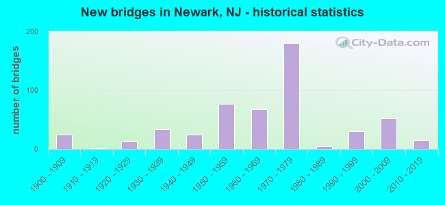
- New bridges - historical statistics
- 251900-1909
- 11910-1919
- 131920-1929
- 341930-1939
- 251940-1949
- 771950-1959
- 681960-1969
- 1801970-1979
- 51980-1989
- 301990-1999
- 522000-2009
- 152010-2019

- Reconstructed bridges - Historical Statistics
- 31940-1949
- 01950-1959
- 51960-1969
- 61970-1979
- 271980-1989
- 191990-1999
- 182000-2009
- 122010-2019
- 22020-2022


- Bridge Condition - Deck
- 7.6%Excellent
- 38.2%Very good
- 43.6%Good
- 9.8%Satisfactory
- 0.9%Fair
- 0.4%Poor

- Bridge Condition - Superstructure
- 12.0%Excellent
- 32.1%Very good
- 30.3%Good
- 20.9%Satisfactory
- 3.4%Fair
- 1.3%Poor
- 0.4%Serious

- Bridge Condition - Substructure
- 4.3%Excellent
- 14.5%Very good
- 51.7%Good
- 28.2%Satisfactory
- 1.3%Fair
- 0.4%Poor

- Bridge Condition - Channel
- 2.2%Excellent
- 31.1%Very good
- 44.4%Good
- 11.1%Satisfactory
- 6.7%Fair
- 4.4%Poor

- Bridge Condition - Culverts
- 16.7%Very good
- 16.7%Good
- 33.3%Satisfactory
- 33.3%Fair
Find on map >> Show street view
Structure Number: 223151, Location: 1.17 MI SO. of NJ46/US1&9 (Lat: 40.835339, Lng: -73.990481), Route carried "on" structure: State highway 63, Year Built: 1931, Year Reconstructed: 1984, Status: Open, Structure Length: 10.00m (32.81ft), Average Daily Traffic: 22,581 (year 2021), Truck Traffic: 4%, Average Future Daily Traffic: 27,553 (year 2041), Features Intersected: NJ 5 & WOLF CREEK
Minimum Vertical Clearance: 30+ m (98+ ft), Kilometerpoint: 3.090, Lanes on structure: 4, Lanes under structure: 2, Base Highway Network: Yes, Owner: State Highway Agency, Approaching Roadway Width: 15.5m (50.9ft), Material/Design: Steel, Design/Construction: Stringer/Multi-beam, Number Of Spans In Main Unit: 7, Length of Maximum Span: 17.7m (58.1ft), Curb or Sidewalk Widths: Left: 1.8m (5.9ft), Right: 1.8m (5.9ft), Curb-To-Curb Width: 15.5m (50.9ft), Out-to-Out Width: 19.8m (65.0ft)
Condition: Deck: Good, Superstructure: Good, Substructure: Fair, Channel: Fair, Inventory Rating: 58.1 metric tons, Method Used To Determine Inventory Rating: Load Factor (LF), Structural Evaluation: Somewhat better than minimum adequacy, Deck Geometry: Meets minimum limits, Underclear: High priority of corrective action, Waterway Adequacy: Superior to present desirable criteria, Approach Roadway Alignment: Better than present minimum criteria, Length Of Structure Improvement: 1.98m (6.50ft), Designated Inspection Frequency: Every 24 months, Critical Feature Inspection Frequency: Every 24 months, Inspection Date: June 2021, Critical Feature Inspection Date: June 2021, Roadway Improvement Cost: $158,000, Total Project Cost: $399,000 ( Estimate for 2020), Deck Structure Type: Concrete Cast-file-Place, Wearing Surface/Protective System: Wearing Surface: Monolithic Concrete, Deck Protection: Epoxy Coated Reinforcing
Find on map >> Show street view
Structure Number: 700008, Location: IN BRANCH BROOK PARK (Lat: 40.764431, Lng: -74.179369), Route carried "on" structure: Spur County highway 506, Year Built: 1904, Year Reconstructed: 1951, Status: Open, Structure Length: 2.13m (6.99ft), Average Daily Traffic: 23,100 (year 2019), Truck Traffic: 4%, Average Future Daily Traffic: 27,730 (year 2039), Features Intersected: Park Road
Minimum Vertical Clearance: 30+ m (98+ ft), Kilometerpoint: 4.925, Lanes on structure: 4, Lanes under structure: 2, Base Highway Network: Yes, Owner: County Highway Agency, Approaching Roadway Width: 21.5m (70.5ft), Material/Design: Concrete, Design/Construction: Arch - Deck, Number Of Spans In Main Unit: 1, Length of Maximum Span: 21.3m (69.9ft), Curb or Sidewalk Widths: Left: 4.6m (15.1ft), Right: 4.6m (15.1ft), Curb-To-Curb Width: 21.5m (70.5ft), Out-to-Out Width: 31.5m (103.3ft)
Condition: Superstructure: Satisfactory, Substructure: Good, Operating Rating: 74.4 metric tons, Method Used To Determine Operating Rating: Allowable Stress (AS), Inventory Rating: 44.5 metric tons, Method Used To Determine Inventory Rating: Allowable Stress (AS), Structural Evaluation: Equal to present minimum criteria, Deck Geometry: Superior to present desirable criteria, Underclear: High priority of corrective action, Approach Roadway Alignment: Equal to present desirable criteria, Length Of Structure Improvement: 2.13m (6.99ft), Designated Inspection Frequency: Every 24 months, Inspection Date: July 2021, Roadway Improvement Cost: $554,000, Total Project Cost: $734,000 ( Estimate for 2021)
Find on map >> Show street view
Structure Number: 700036, Location: 160 FT. S.OF MILL STREET (Lat: 40.781219, Lng: -74.154639), Route carried "on" structure: County highway 667, Year Built: 1903, Status: Open, Structure Length: 2.23m (7.32ft), Average Daily Traffic: 14,269 (year 2020), Truck Traffic: 4%, Average Future Daily Traffic: 17,408 (year 2040), Features Intersected: SECOND RIVER
Minimum Vertical Clearance: 30+ m (98+ ft), Kilometerpoint: 3.412, Lanes on structure: 4, Owner: County Highway Agency, Approaching Roadway Width: 17.7m (58.1ft), Material/Design: Masonry, Design/Construction: Arch - Deck, Number Of Spans In Main Unit: 3, Length of Maximum Span: 5.5m (18.0ft), Curb or Sidewalk Widths: Left: 1.9m (6.2ft), Right: 2.1m (6.9ft), Curb-To-Curb Width: 17.9m (58.7ft), Out-to-Out Width: 22.6m (74.1ft)
Condition: Superstructure: Fair, Substructure: Satisfactory, Channel: Poor, Operating Rating: 38.1 metric tons, Method Used To Determine Operating Rating: Field evaluation and documented engineering judgment, Inventory Rating: 22.7 metric tons, Method Used To Determine Inventory Rating: Field evaluation and documented engineering judgment, Structural Evaluation: Somewhat better than minimum adequacy, Deck Geometry: Somewhat better than minimum adequacy, Waterway Adequacy: Superior to present desirable criteria, Approach Roadway Alignment: Equal to present desirable criteria, Designated Inspection Frequency: Every 24 months, Inspection Date: September 2020
Find on map >> Show street view
Structure Number: 700039, Location: 0.53 MI.S OF ORANGE AVE. (Lat: 40.736519, Lng: -74.228569), Route carried "on" structure: City street , Year Built: 1920, Status: Open, Structure Length: 0.98m (3.22ft), Average Daily Traffic: 1,679 (year 2020), Truck Traffic: 4%, Average Future Daily Traffic: 2,048 (year 2040), Features Intersected: ELIZABETH RIVER, Facility Carried by Structure: VALLEY STREET
Minimum Vertical Clearance: 30+ m (98+ ft), Kilometerpoint: 0.354, Lanes on structure: 2, Owner: County Highway Agency, Approaching Roadway Width: 12.2m (40.0ft), Skew: 3 degrees, Material/Design: Concrete, Design/Construction: Culvert, Number Of Spans In Main Unit: 2, Length of Maximum Span: 5.2m (17.1ft), Curb or Sidewalk Widths: Left: 3.5m (11.5ft), Right: 2.8m (9.2ft), Curb-To-Curb Width: 12.1m (39.7ft), Out-to-Out Width: 25.0m (82.0ft)
Condition: Channel: Satisfactory, Culverts: Fair, Operating Rating: 38.1 metric tons, Method Used To Determine Operating Rating: Field evaluation and documented engineering judgment, Inventory Rating: 22.7 metric tons, Method Used To Determine Inventory Rating: Field evaluation and documented engineering judgment, Structural Evaluation: Somewhat better than minimum adequacy, Deck Geometry: Equal to present minimum criteria, Waterway Adequacy: Better than present minimum criteria, Approach Roadway Alignment: Equal to present desirable criteria, Designated Inspection Frequency: Every 24 months, Inspection Date: August 2020
Find on map >> Show street view
Structure Number: 700069, Location: .5 MI.E. OF RTE.21 (Lat: 40.732619, Lng: -74.155189), Route carried "on" structure: City street , Year Built: 1991, Status: Open, Structure Length: 2.13m (6.99ft), Average Daily Traffic: 24,444 (year 2019), Truck Traffic: 3%, Average Future Daily Traffic: 29,333 (year 2039), Design Load: HS 20+Mod, Features Intersected: Raymond Boulevard, Facility Carried by Structure: Jackson Street
Minimum Vertical Clearance: 30+ m (98+ ft), Kilometerpoint: 0.644, Lanes on structure: 2, Lanes under structure: 3, Owner: County Highway Agency, Approaching Roadway Width: 12.2m (40.0ft), Material/Design: Steel, Design/Construction: Stringer/Multi-beam, Number Of Spans In Main Unit: 1, Length of Maximum Span: 19.8m (65.0ft), Curb or Sidewalk Widths: Left: 1.8m (5.9ft), Right: 1.8m (5.9ft), Curb-To-Curb Width: 12.2m (40.0ft), Out-to-Out Width: 16.5m (54.1ft)
Condition: Deck: Good, Superstructure: Satisfactory, Substructure: Good, Operating Rating: 84.4 metric tons, Method Used To Determine Operating Rating: Load Factor (LF), Inventory Rating: 50.8 metric tons, Method Used To Determine Inventory Rating: Load Factor (LF), Structural Evaluation: Equal to present minimum criteria, Deck Geometry: Somewhat better than minimum adequacy, Underclear: High priority of corrective action, Approach Roadway Alignment: Better than present minimum criteria, Length Of Structure Improvement: 2.13m (6.99ft), Designated Inspection Frequency: Every 24 months, Inspection Date: August 2021, Bridge Improvement Cost: $1,000, Roadway Improvement Cost: $24,000, Total Project Cost: $27,000 ( Estimate for 2019), Deck Structure Type: Concrete Cast-file-Place, Wearing Surface/Protective System: Wearing Surface: Monolithic Concrete, Deck Protection: Epoxy Coated Reinforcing
Find on map >> Show street view
Structure Number: 700076, Location: 300 S OF TJNK OF ML ST (Lat: 40.785981, Lng: -74.165031), Route carried "on" structure: City street , Year Built: 1900, Status: Open, Structure Length: 2.10m (6.89ft), Average Daily Traffic: 10,475 (year 2020), Truck Traffic: 3%, Average Future Daily Traffic: 12,779 (year 2040), Features Intersected: SECOND RIVER, Facility Carried by Structure: MILL ST&BRCH BK RD
Minimum Vertical Clearance: 30+ m (98+ ft), Kilometerpoint: 3.042, Lanes on structure: 2, Owner: County Highway Agency, Approaching Roadway Width: 12.2m (40.0ft), Material/Design: Concrete, Design/Construction: Arch - Deck, Number Of Spans In Main Unit: 1, Length of Maximum Span: 21.0m (68.9ft), Curb or Sidewalk Widths: Left: 2.4m (7.9ft), Right: 2.3m (7.5ft), Curb-To-Curb Width: 12.2m (40.0ft), Out-to-Out Width: 17.7m (58.1ft)
Condition: Superstructure: Satisfactory, Substructure: Good, Channel: Good, Operating Rating: 28.1 metric tons, Method Used To Determine Operating Rating: Field evaluation and documented engineering judgment, Inventory Rating: 17.2 metric tons, Method Used To Determine Inventory Rating: Field evaluation and documented engineering judgment, Structural Evaluation: Meets minimum limits, Deck Geometry: Somewhat better than minimum adequacy, Waterway Adequacy: Superior to present desirable criteria, Approach Roadway Alignment: Equal to present minimum criteria, Designated Inspection Frequency: Every 24 months, Inspection Date: August 2020
Find on map >> Show street view
Structure Number: 700077, Location: .13 MI WEST OF CLIFTON AV (Lat: 40.753439, Lng: -74.181139), Route carried "on" structure: City street , Year Built: 1900, Status: Open, Structure Length: 0.67m (2.20ft), Average Daily Traffic: 1,756 (year 2020), Truck Traffic: 1%, Average Future Daily Traffic: 2,142 (year 2040), Features Intersected: FOOTPATH, Facility Carried by Structure: BRANCH BROOK PK RD
Minimum Vertical Clearance: 30+ m (98+ ft), Kilometerpoint: 0.000, Lanes on structure: 2, Owner: County Highway Agency, Approaching Roadway Width: 12.5m (41.0ft), Material/Design: Masonry, Design/Construction: Arch - Deck, Number Of Spans In Main Unit: 1, Length of Maximum Span: 6.7m (22.0ft), Curb or Sidewalk Widths: Left: 4.5m (14.8ft), Right: 0.0m, Curb-To-Curb Width: 12.4m (40.7ft), Out-to-Out Width: 20.3m (66.6ft)
Condition: Superstructure: Satisfactory, Substructure: Good, Operating Rating: 38.1 metric tons, Method Used To Determine Operating Rating: Field evaluation and documented engineering judgment, Inventory Rating: 22.7 metric tons, Method Used To Determine Inventory Rating: Field evaluation and documented engineering judgment, Structural Evaluation: Equal to present minimum criteria, Deck Geometry: Better than present minimum criteria, Approach Roadway Alignment: Equal to present minimum criteria, Designated Inspection Frequency: Every 24 months, Inspection Date: August 2020
Find on map >> Show street view
Structure Number: 700078, Location: IN BRANCHBROOK PARK (Lat: 40.752389, Lng: -74.183300), Route carried "on" structure: City street , Year Built: 1971, Status: Open, Structure Length: 1.62m (5.31ft), Average Daily Traffic: 1,734 (year 2020), Truck Traffic: 1%, Average Future Daily Traffic: 2,115 (year 2040), Design Load: HS 15, Features Intersected: BRANCH BROOK PK LAKE, Facility Carried by Structure: BRANCH BROOK PK RD
Minimum Vertical Clearance: 30+ m (98+ ft), Kilometerpoint: 0.000, Lanes on structure: 2, Owner: County Highway Agency, Approaching Roadway Width: 12.2m (40.0ft), Skew: 1 degrees, Material/Design: Concrete, Design/Construction: Arch - Deck, Number Of Spans In Main Unit: 1, Length of Maximum Span: 16.2m (53.1ft), Curb or Sidewalk Widths: Left: 2.4m (7.9ft), Right: 0.4m (1.3ft), Curb-To-Curb Width: 12.1m (39.7ft), Out-to-Out Width: 15.7m (51.5ft)
Condition: Superstructure: Satisfactory, Substructure: Satisfactory, Channel: Satisfactory, Operating Rating: 89.8 metric tons, Method Used To Determine Operating Rating: Allowable Stress (AS), Inventory Rating: 89.8 metric tons, Method Used To Determine Inventory Rating: Allowable Stress (AS), Structural Evaluation: Equal to present minimum criteria, Deck Geometry: Equal to present minimum criteria, Waterway Adequacy: Superior to present desirable criteria, Approach Roadway Alignment: Equal to present minimum criteria, Designated Inspection Frequency: Every 24 months, Underwater Inspection Frequency: Every 48 months, Inspection Date: August 2020, Underwater Inspection Date: September 2018
Find on map >> Show street view
Structure Number: 700079, Location: IN WEEQUAHIC PARK (Lat: 40.699761, Lng: -74.211200), Route carried "on" structure: City street , Year Built: 1931, Year Reconstructed: 2009, Status: Open, Structure Length: 3.72m (12.20ft), Average Daily Traffic: 5,292 (year 2020), Truck Traffic: 1%, Average Future Daily Traffic: 6,456 (year 2040), Features Intersected: CONRAIL, Facility Carried by Structure: WEEQUAHIC PARK RD.
Minimum Vertical Clearance: 30+ m (98+ ft), Kilometerpoint: 0.000, Lanes on structure: 2, Owner: County Highway Agency, Approaching Roadway Width: 12.2m (40.0ft), Material/Design: Concrete, Design/Construction: Arch - Deck, Number Of Spans In Main Unit: 1, Length of Maximum Span: 37.2m (122.0ft), Curb or Sidewalk Widths: Left: 2.4m (7.9ft), Right: 2.4m (7.9ft), Curb-To-Curb Width: 12.2m (40.0ft), Out-to-Out Width: 17.8m (58.4ft)
Condition: Deck: Good, Superstructure: Satisfactory, Substructure: Satisfactory, Operating Rating: 89.8 metric tons, Method Used To Determine Operating Rating: Allowable Stress (AS), Inventory Rating: 89.8 metric tons, Method Used To Determine Inventory Rating: Allowable Stress (AS), Structural Evaluation: Equal to present minimum criteria, Deck Geometry: Somewhat better than minimum adequacy, Underclear: Superior to present desirable criteria, Approach Roadway Alignment: Equal to present minimum criteria, Designated Inspection Frequency: Every 24 months, Inspection Date: September 2020, Deck Structure Type: Concrete Precast Panels, Wearing Surface/Protective System: Wearing Surface: Bituminous, Membrane: Other, Deck Protection: Epoxy Coated Reinforcing
Find on map >> Show street view
Structure Number: 700101, Location: IN BRANCH BROOK PARK (Lat: 40.757800, Lng: -74.181811), Route carried "on" structure: County highway 658, Year Built: 1905, Status: Open, Structure Length: 4.02m (13.19ft), Average Daily Traffic: 18,605 (year 2019), Truck Traffic: 4%, Average Future Daily Traffic: 22,330 (year 2039), Features Intersected: Park Rd & Branch Brook, Facility Carried by Structure: Park Avenue
Minimum Vertical Clearance: 30+ m (98+ ft), Kilometerpoint: 5.407, Lanes on structure: 2, Lanes under structure: 2, Base Highway Network: Yes, Owner: County Highway Agency, Approaching Roadway Width: 12.3m (40.4ft), Material/Design: Concrete, Design/Construction: Arch - Deck, Number Of Spans In Main Unit: 1, Length of Maximum Span: 40.2m (131.9ft), Curb or Sidewalk Widths: Left: 4.0m (13.1ft), Right: 3.4m (11.2ft), Curb-To-Curb Width: 12.3m (40.4ft), Out-to-Out Width: 22.9m (75.1ft)
Condition: Superstructure: Satisfactory, Substructure: Good, Channel: Very good, Operating Rating: 33.6 metric tons, Method Used To Determine Operating Rating: Load Factor (LF), Inventory Rating: 20.9 metric tons, Method Used To Determine Inventory Rating: Load Factor (LF), Structural Evaluation: Somewhat better than minimum adequacy, Deck Geometry: Somewhat better than minimum adequacy, Underclear: Equal to present minimum criteria, Waterway Adequacy: Equal to present desirable criteria, Approach Roadway Alignment: Equal to present minimum criteria, Designated Inspection Frequency: Every 24 months, Inspection Date: August 2021
Find on map >> Show street view
Structure Number: 700H01, Location: 0.2 MI NE I-280&NJ21 JCT (Lat: 40.751089, Lng: -74.165819), Route carried "on" structure: City street , Year Built: 1908, Year Reconstructed: 1976, Status: Open, Structure Length: 10.00m (32.81ft), Average Daily Traffic: 21,063 (year 2020), Truck Traffic: 3%, Average Future Daily Traffic: 25,700 (year 2040), Features Intersected: PASSAIC RIVER, Facility Carried by Structure: CLAY STREET
Minimum Vertical Clearance: 5.05m (16.57ft), Kilometerpoint: 0.177, Lanes on structure: 2, Owner: County Highway Agency, Approaching Roadway Width: 11.6m (38.1ft), Navigation Control: Yes ( Vertical Clearance: 2.1m (6.9ft), Horizontal Clearance: 22.9m (75.1ft)), Material/Design: Steel, Design/Construction: Movable - Swing, Number Of Spans In Main Unit: 2, Number Of Approach Spans: 2, Length of Maximum Span: 36.0m (118.1ft), Curb or Sidewalk Widths: Left: 2.4m (7.9ft), Right: 2.4m (7.9ft), Curb-To-Curb Width: 11.1m (36.4ft), Out-to-Out Width: 12.0m (39.4ft)
Condition: Deck: Satisfactory, Superstructure: Serious, Substructure: Fair, Channel: Poor, Operating Rating: 17.2 metric tons, Method Used To Determine Operating Rating: Load Factor (LF), Inventory Rating: 10.0 metric tons, Method Used To Determine Inventory Rating: Load Factor (LF), Structural Evaluation: High priority of corrective action, Deck Geometry: Meets minimum limits, Waterway Adequacy: Superior to present desirable criteria, Approach Roadway Alignment: Equal to present minimum criteria, Length Of Structure Improvement: 7.19m (23.59ft), Designated Inspection Frequency: Every 24 months, Critical Feature Inspection Frequency: Every 24 months, Underwater Inspection Frequency: Every 24 months, Other Special Inspection Frequency: Every 12 months, Inspection Date: September 2020, Critical Feature Inspection Date: September 2020, Underwater Inspection Date: October 2020, Other Special Inspection Date: September 2021, Bridge Improvement Cost: $136,000, Total Project Cost: $979,000 ( Estimate for 2020), Deck Structure Type: Concrete Cast-file-Place, Wearing Surface/Protective System: Wearing Surface: Monolithic Concrete, Deck Protection: Epoxy Coated Reinforcing
Find on map >> Show street view
Structure Number: 700H02, Location: 1.2 MI SE I-280&NJ21 JCT (Lat: 40.734411, Lng: -74.155169), Route carried "on" structure: City street , Year Built: 1900, Year Reconstructed: 1991, Status: Open, Structure Length: 14.23m (46.69ft), Average Daily Traffic: 19,067 (year 2020), Truck Traffic: 3%, Average Future Daily Traffic: 23,265 (year 2040), Features Intersected: PASSAIC RIVER, Facility Carried by Structure: JACKSON STREET
Minimum Vertical Clearance: 5.05m (16.57ft), Kilometerpoint: 0.756, Lanes on structure: 2, Owner: County Highway Agency, Approaching Roadway Width: 11.9m (39.0ft), Navigation Control: Yes ( Vertical Clearance: 4.6m (15.1ft), Horizontal Clearance: 22.3m (73.2ft)), Material/Design: Steel, Design/Construction: Movable - Swing, Number Of Spans In Main Unit: 2, Number Of Approach Spans: 2, Length of Maximum Span: 52.4m (171.9ft), Curb or Sidewalk Widths: Left: 2.0m (6.6ft), Right: 2.0m (6.6ft), Curb-To-Curb Width: 11.9m (39.0ft), Out-to-Out Width: 12.3m (40.4ft)
Condition: Deck: Good, Superstructure: Fair, Substructure: Fair, Channel: Satisfactory, Operating Rating: 34.5 metric tons, Method Used To Determine Operating Rating: Load Factor (LF), Inventory Rating: 20.9 metric tons, Method Used To Determine Inventory Rating: Load Factor (LF), Structural Evaluation: Somewhat better than minimum adequacy, Deck Geometry: Somewhat better than minimum adequacy, Waterway Adequacy: Superior to present desirable criteria, Approach Roadway Alignment: Equal to present minimum criteria, Length Of Structure Improvement: 14.23m (46.69ft), Designated Inspection Frequency: Every 24 months, Critical Feature Inspection Frequency: Every 24 months, Underwater Inspection Frequency: Every 24 months, Inspection Date: October 2020, Critical Feature Inspection Date: October 2020, Underwater Inspection Date: October 2020, Bridge Improvement Cost: $720,000, Total Project Cost: $720,000 ( Estimate for 2016), Deck Structure Type: Open Grating, Wearing Surface/Protective System: Wearing Surface: Monolithic Concrete, Deck Protection: Epoxy Coated Reinforcing
Find on map >> Show street view
Structure Number: 700H03, Location: 0.3 MI SE I-280&NJ21 JCT (Lat: 40.745139, Lng: -74.166431), Route carried "on" structure: County highway 508, Year Built: 1913, Year Reconstructed: 1981, Status: Open, Structure Length: 11.31m (37.11ft), Average Daily Traffic: 10,395 (year 2020), Truck Traffic: 4%, Average Future Daily Traffic: 12,683 (year 2040), Features Intersected: PASSAIC RIVER
Minimum Vertical Clearance: 5.26m (17.26ft), Kilometerpoint: 19.763, Lanes on structure: 2, Owner: County Highway Agency, Approaching Roadway Width: 11.9m (39.0ft), Navigation Control: Yes ( Vertical Clearance: 2.1m (6.9ft), Horizontal Clearance: 24.4m (80.1ft)), Material/Design: Steel, Design/Construction: Movable - Swing, Number Of Spans In Main Unit: 2, Number Of Approach Spans: 2, Length of Maximum Span: 37.2m (122.0ft), Curb or Sidewalk Widths: Left: 2.2m (7.2ft), Right: 2.2m (7.2ft), Curb-To-Curb Width: 11.9m (39.0ft), Out-to-Out Width: 12.3m (40.4ft)
Condition: Deck: Satisfactory, Superstructure: Poor, Substructure: Satisfactory, Channel: Fair, Operating Rating: 33.6 metric tons, Method Used To Determine Operating Rating: Load Factor (LF), Inventory Rating: 20.0 metric tons, Method Used To Determine Inventory Rating: Load Factor (LF), Structural Evaluation: Meets minimum limits, Deck Geometry: Somewhat better than minimum adequacy, Waterway Adequacy: Better than present minimum criteria, Approach Roadway Alignment: Equal to present desirable criteria, Length Of Structure Improvement: 7.44m (24.41ft), Designated Inspection Frequency: Every 24 months, Critical Feature Inspection Frequency: Every 24 months, Underwater Inspection Frequency: Every 48 months, Inspection Date: October 2020, Critical Feature Inspection Date: October 2020, Underwater Inspection Date: October 2018, Bridge Improvement Cost: $1,345,000, Total Project Cost: $1,815,000 ( Estimate for 2020), Deck Structure Type: Open Grating
Find on map >> Show street view
Structure Number: 700N01, Location: 2.1 MI NE I-280&NJ21 JCT (Lat: 40.778450, Lng: -74.175200), Route carried "on" structure: City street , Year Built: 1900, Year Reconstructed: 1985, Status: Open, Structure Length: 1.58m (5.18ft), Average Daily Traffic: 16,529 (year 2020), Truck Traffic: 4%, Average Future Daily Traffic: 20,168 (year 2040), Features Intersected: CITY SUBWAY, Facility Carried by Structure: HELLER PARKWAY
Minimum Vertical Clearance: 30+ m (98+ ft), Kilometerpoint: 0.113, Lanes on structure: 4, Owner: City or Municipal Highway Agency, Approaching Roadway Width: 15.2m (49.9ft), Material/Design: Prestressed concrete, Design/Construction: Box Beam or Girders - Multiple, Number Of Spans In Main Unit: 1, Length of Maximum Span: 13.4m (44.0ft), Curb or Sidewalk Widths: Left: 2.8m (9.2ft), Right: 2.7m (8.9ft), Curb-To-Curb Width: 15.3m (50.2ft), Out-to-Out Width: 21.4m (70.2ft)
Condition: Deck: Fair, Superstructure: Fair, Substructure: Satisfactory, Operating Rating: 45.4 metric tons, Method Used To Determine Operating Rating: Field evaluation and documented engineering judgment, Inventory Rating: 27.2 metric tons, Method Used To Determine Inventory Rating: Field evaluation and documented engineering judgment, Structural Evaluation: Somewhat better than minimum adequacy, Deck Geometry: High priority of corrective action, Underclear: High priority of corrective action, Approach Roadway Alignment: Equal to present minimum criteria, Designated Inspection Frequency: Every 24 months, Inspection Date: September 2020, Deck Structure Type: Concrete Cast-file-Place, Wearing Surface/Protective System: Wearing Surface: Monolithic Concrete
Find on map >> Show street view
Structure Number: 700N02, Location: 1.4 MI NW I-280&NJ21 JCT (Lat: 40.765661, Lng: -74.179869), Route carried "on" structure: Spur County highway 506, Year Built: 1932, Year Reconstructed: 1951, Status: Open, Structure Length: 1.62m (5.31ft), Average Daily Traffic: 21,033 (year 2020), Truck Traffic: 4%, Average Future Daily Traffic: 25,664 (year 2040), Features Intersected: CITY SUBWAY
Minimum Vertical Clearance: 30+ m (98+ ft), Kilometerpoint: 4.780, Lanes on structure: 5, Base Highway Network: Yes, Owner: City or Municipal Highway Agency, Approaching Roadway Width: 21.3m (69.9ft), Skew: 3 degrees, Material/Design: Steel, Design/Construction: Stringer/Multi-beam, Number Of Spans In Main Unit: 2, Length of Maximum Span: 15.5m (50.9ft), Curb or Sidewalk Widths: Left: 4.4m (14.4ft), Right: 4.4m (14.4ft), Curb-To-Curb Width: 21.4m (70.2ft), Out-to-Out Width: 31.2m (102.4ft)
Condition: Deck: Satisfactory, Superstructure: Fair, Substructure: Fair, Operating Rating: 49.0 metric tons, Method Used To Determine Operating Rating: Load Factor (LF), Inventory Rating: 29.0 metric tons, Method Used To Determine Inventory Rating: Load Factor (LF), Structural Evaluation: Somewhat better than minimum adequacy, Deck Geometry: Somewhat better than minimum adequacy, Underclear: High priority of corrective action, Approach Roadway Alignment: Equal to present desirable criteria, Designated Inspection Frequency: Every 24 months, Inspection Date: October 2020, Deck Structure Type: Concrete Cast-file-Place, Wearing Surface/Protective System: Wearing Surface: Bituminous
Find on map >> Show street view
Structure Number: 700N03, Location: 1.2 MI NW I-280&NJ21 JCT (Lat: 40.758531, Lng: -74.185100), Route carried "on" structure: County highway 658, Year Built: 1932, Status: Open, Structure Length: 1.34m (4.40ft), Average Daily Traffic: 18,787 (year 2020), Truck Traffic: 4%, Average Future Daily Traffic: 22,923 (year 2040), Features Intersected: CITY SUBWAY
Minimum Vertical Clearance: 30+ m (98+ ft), Kilometerpoint: 5.102, Lanes on structure: 4, Base Highway Network: Yes, Owner: City or Municipal Highway Agency, Approaching Roadway Width: 17.7m (58.1ft), Material/Design: Steel, Design/Construction: Stringer/Multi-beam, Number Of Spans In Main Unit: 2, Length of Maximum Span: 6.4m (21.0ft), Curb or Sidewalk Widths: Left: 6.3m (20.7ft), Right: 6.3m (20.7ft), Curb-To-Curb Width: 17.7m (58.1ft), Out-to-Out Width: 31.3m (102.7ft)
Condition: Deck: Very good, Superstructure: Satisfactory, Substructure: Fair, Operating Rating: 55.3 metric tons, Method Used To Determine Operating Rating: Load Factor (LF), Inventory Rating: 33.6 metric tons, Method Used To Determine Inventory Rating: Load Factor (LF), Structural Evaluation: Somewhat better than minimum adequacy, Deck Geometry: Somewhat better than minimum adequacy, Underclear: High priority of corrective action, Approach Roadway Alignment: Equal to present desirable criteria, Designated Inspection Frequency: Every 24 months, Inspection Date: October 2020, Deck Structure Type: Concrete Cast-file-Place, Wearing Surface/Protective System: Wearing Surface: Bituminous
Find on map >> Show street view
Structure Number: 700N04, Location: 1.0 MI W I-280&NJ21 JCT (Lat: 40.749081, Lng: -74.186319), Route carried "on" structure: City street , Year Built: 1929, Status: Open, Structure Length: 1.46m (4.79ft), Average Daily Traffic: 3,281 (year 2020), Truck Traffic: 3%, Average Future Daily Traffic: 4,003 (year 2040), Features Intersected: CITY SUBWAY, Facility Carried by Structure: SUSSEX AVENUE
Minimum Vertical Clearance: 30+ m (98+ ft), Kilometerpoint: 0.724, Lanes on structure: 3, Owner: City or Municipal Highway Agency, Approaching Roadway Width: 11.9m (39.0ft), Skew: 1 degrees, Material/Design: Steel, Design/Construction: Stringer/Multi-beam, Number Of Spans In Main Unit: 1, Length of Maximum Span: 12.5m (41.0ft), Curb or Sidewalk Widths: Left: 3.0m (9.8ft), Right: 3.3m (10.8ft), Curb-To-Curb Width: 11.9m (39.0ft), Out-to-Out Width: 20.2m (66.3ft)
Condition: Deck: Fair, Superstructure: Fair, Substructure: Fair, Operating Rating: 39.0 metric tons, Method Used To Determine Operating Rating: Field evaluation and documented engineering judgment, Inventory Rating: 22.7 metric tons, Method Used To Determine Inventory Rating: Field evaluation and documented engineering judgment, Structural Evaluation: Somewhat better than minimum adequacy, Deck Geometry: High priority of corrective action, Underclear: High priority of corrective action, Approach Roadway Alignment: Equal to present desirable criteria, Designated Inspection Frequency: Every 24 months, Inspection Date: October 2020, Deck Structure Type: Concrete Cast-file-Place, Wearing Surface/Protective System: Wearing Surface: Bituminous
Find on map >> Show street view
Structure Number: 700N05, Location: 1.0 MI SW I-280&NJ21 JCT (Lat: 40.747469, Lng: -74.186211), Route carried "on" structure: City street , Year Built: 1929, Status: Open, Structure Length: 1.04m (3.41ft), Average Daily Traffic: 3,683 (year 2020), Truck Traffic: 1%, Average Future Daily Traffic: 4,493 (year 2040), Features Intersected: CITY SUBWAY, Facility Carried by Structure: DICKERSON & DURYEA
Minimum Vertical Clearance: 30+ m (98+ ft), Kilometerpoint: 0.000, Lanes on structure: 2, Owner: City or Municipal Highway Agency, Approaching Roadway Width: 9.1m (29.9ft), Skew: 9 degrees, Material/Design: Steel, Design/Construction: Stringer/Multi-beam, Number Of Spans In Main Unit: 2, Length of Maximum Span: 4.6m (15.1ft), Curb or Sidewalk Widths: Left: 2.4m (7.9ft), Right: 2.5m (8.2ft), Curb-To-Curb Width: 29.5m (96.8ft), Out-to-Out Width: 36.4m (119.4ft)
Condition: Deck: Fair, Superstructure: Fair, Substructure: Fair, Operating Rating: 82.6 metric tons, Method Used To Determine Operating Rating: Load Factor (LF), Inventory Rating: 49.9 metric tons, Method Used To Determine Inventory Rating: Load Factor (LF), Structural Evaluation: Somewhat better than minimum adequacy, Deck Geometry: Superior to present desirable criteria, Underclear: High priority of corrective action, Approach Roadway Alignment: Equal to present desirable criteria, Designated Inspection Frequency: Every 24 months, Inspection Date: October 2020, Deck Structure Type: Concrete Cast-file-Place, Wearing Surface/Protective System: Wearing Surface: Bituminous
Find on map >> Show street view
Structure Number: 700N06, Location: 1.0 MI SW I-280&NJ21 JCT (Lat: 40.746439, Lng: -74.185411), Route carried "on" structure: County highway 508, Year Built: 1908, Status: Posted for load, Structure Length: 3.60m (11.81ft), Average Daily Traffic: 11,490 (year 2020), Truck Traffic: 4%, Average Future Daily Traffic: 14,020 (year 2040), Features Intersected: CITY SUBWAY
Minimum Vertical Clearance: 30+ m (98+ ft), Kilometerpoint: 16.657, Lanes on structure: 2, Base Highway Network: Yes, Owner: City or Municipal Highway Agency, Approaching Roadway Width: 14.3m (46.9ft), Skew: 9 degrees, Material/Design: Steel, Design/Construction: Truss - Thru, Number Of Spans In Main Unit: 4, Length of Maximum Span: 34.4m (112.9ft), Curb or Sidewalk Widths: Left: 4.4m (14.4ft), Right: 4.4m (14.4ft), Curb-To-Curb Width: 14.4m (47.2ft), Out-to-Out Width: 23.8m (78.1ft)
Condition: Deck: Fair, Superstructure: Poor, Substructure: Fair, Operating Rating: 14.5 metric tons, Method Used To Determine Operating Rating: Load Factor (LF), Inventory Rating: 8.2 metric tons, Method Used To Determine Inventory Rating: Load Factor (LF), Structural Evaluation: High priority of replacement, Deck Geometry: Superior to present desirable criteria, Underclear: High priority of replacement, Approach Roadway Alignment: Equal to present desirable criteria, Bridge Posting: Required (Relationship of Operating Rating to Maximum Legal Load: > 39.9% below), Length Of Structure Improvement: 3.60m (11.81ft), Designated Inspection Frequency: Every 24 months, Critical Feature Inspection Frequency: Every 24 months, Other Special Inspection Frequency: Every 12 months, Inspection Date: September 2020, Critical Feature Inspection Date: September 2020, Other Special Inspection Date: September 2021, Bridge Improvement Cost: $6,654,000, Roadway Improvement Cost: $141,000, Total Project Cost: $14,807,000 ( Estimate for 2020), Deck Structure Type: Concrete Cast-file-Place, Wearing Surface/Protective System: Wearing Surface: Bituminous
Find on map >> Show street view
Structure Number: 700N07, Location: 0.8 MI SW I-280&NJ21 JCT (Lat: 40.745369, Lng: -74.183250), Route carried "on" structure: City street , Year Built: 1929, Status: Open, Structure Length: 1.46m (4.79ft), Average Daily Traffic: 10,454 (year 2020), Truck Traffic: 4%, Average Future Daily Traffic: 12,756 (year 2040), Features Intersected: CITY SUBWAY, Facility Carried by Structure: NORFOLK STREET
Minimum Vertical Clearance: 30+ m (98+ ft), Kilometerpoint: 3.734, Lanes on structure: 2, Owner: City or Municipal Highway Agency, Approaching Roadway Width: 11.9m (39.0ft), Material/Design: Steel, Design/Construction: Stringer/Multi-beam, Number Of Spans In Main Unit: 2, Length of Maximum Span: 7.0m (23.0ft), Curb or Sidewalk Widths: Left: 4.1m (13.5ft), Right: 12.1m (39.7ft), Curb-To-Curb Width: 11.8m (38.7ft), Out-to-Out Width: 28.7m (94.2ft)
Condition: Deck: Fair, Superstructure: Fair, Substructure: Fair, Operating Rating: 71.7 metric tons, Method Used To Determine Operating Rating: Load Factor (LF), Inventory Rating: 42.6 metric tons, Method Used To Determine Inventory Rating: Load Factor (LF), Structural Evaluation: Somewhat better than minimum adequacy, Deck Geometry: Somewhat better than minimum adequacy, Underclear: High priority of corrective action, Approach Roadway Alignment: Equal to present desirable criteria, Designated Inspection Frequency: Every 24 months, Inspection Date: October 2020, Deck Structure Type: Concrete Cast-file-Place, Wearing Surface/Protective System: Wearing Surface: Bituminous
Find on map >> Show street view
Structure Number: 700N08, Location: 0.8 MI SW I-280&NJ21 JCT (Lat: 40.745200, Lng: -74.182500), Route carried "on" structure: City street , Year Built: 1929, Status: Open, Structure Length: 0.98m (3.22ft), Average Daily Traffic: 2,142 (year 2020), Truck Traffic: 1%, Average Future Daily Traffic: 2,614 (year 2040), Features Intersected: CITY SUBWAY, Facility Carried by Structure: NEWARK STREET
Minimum Vertical Clearance: 30+ m (98+ ft), Kilometerpoint: 0.000, Lanes on structure: 2, Owner: City or Municipal Highway Agency, Approaching Roadway Width: 11.0m (36.1ft), Material/Design: Steel, Design/Construction: Stringer/Multi-beam, Number Of Spans In Main Unit: 2, Length of Maximum Span: 4.3m (14.1ft), Curb or Sidewalk Widths: Left: 3.7m (12.1ft), Right: 3.5m (11.5ft), Curb-To-Curb Width: 10.9m (35.8ft), Out-to-Out Width: 19.1m (62.7ft)
Condition: Deck: Fair, Superstructure: Fair, Substructure: Fair, Operating Rating: 49.9 metric tons, Method Used To Determine Operating Rating: Load Factor (LF), Inventory Rating: 29.9 metric tons, Method Used To Determine Inventory Rating: Load Factor (LF), Structural Evaluation: Somewhat better than minimum adequacy, Deck Geometry: Somewhat better than minimum adequacy, Underclear: High priority of corrective action, Approach Roadway Alignment: Equal to present desirable criteria, Designated Inspection Frequency: Every 24 months, Inspection Date: October 2020, Deck Structure Type: Concrete Cast-file-Place, Wearing Surface/Protective System: Wearing Surface: Bituminous
Find on map >> Show street view
Structure Number: 700N09, Location: 1.0 mi west of NJ 21 (Lat: 40.739819, Lng: -74.179261), Route carried "on" structure: City street , Year Built: 1930, Status: Open, Structure Length: 1.83m (6.00ft), Average Daily Traffic: 604 (year 2021), Truck Traffic: 1%, Average Future Daily Traffic: 725 (year 2041), Features Intersected: Raymond Boulevard, Facility Carried by Structure: Summit Street
Minimum Vertical Clearance: 30+ m (98+ ft), Kilometerpoint: 0.000, Lanes on structure: 1, Lanes under structure: 4, Owner: City or Municipal Highway Agency, Approaching Roadway Width: 10.1m (33.1ft), Material/Design: Concrete, Design/Construction: Frame, Number Of Spans In Main Unit: 1, Length of Maximum Span: 18.3m (60.0ft), Curb or Sidewalk Widths: Left: 3.2m (10.5ft), Right: 3.2m (10.5ft), Curb-To-Curb Width: 10.1m (33.1ft), Out-to-Out Width: 18.8m (61.7ft)
Condition: Superstructure: Satisfactory, Substructure: Satisfactory, Operating Rating: 35.4 metric tons, Method Used To Determine Operating Rating: Field evaluation and documented engineering judgment, Inventory Rating: 20.9 metric tons, Method Used To Determine Inventory Rating: Field evaluation and documented engineering judgment, Structural Evaluation: Somewhat better than minimum adequacy, Deck Geometry: Equal to present minimum criteria, Underclear: High priority of corrective action, Approach Roadway Alignment: Equal to present desirable criteria, Length Of Structure Improvement: 1.83m (6.00ft), Designated Inspection Frequency: Every 24 months, Inspection Date: September 2021, Bridge Improvement Cost: $1,000, Roadway Improvement Cost: $35,000, Total Project Cost: $40,000 ( Estimate for 2021)
Find on map >> Show street view
Structure Number: 700N1, Location: .24 mi N of RT 510 (Lat: 40.739431, Lng: -74.177969), Route carried "on" structure: City street , Year Built: 1930, Status: Open, Structure Length: 1.83m (6.00ft), Average Daily Traffic: 14,800 (year 2019), Truck Traffic: 3%, Average Future Daily Traffic: 17,760 (year 2039), Features Intersected: Raymond Boulevard, Facility Carried by Structure: Dr. MLK Boulevard
Minimum Vertical Clearance: 30+ m (98+ ft), Kilometerpoint: 1.754, Lanes on structure: 2, Lanes under structure: 4, Owner: City or Municipal Highway Agency, Approaching Roadway Width: 12.2m (40.0ft), Material/Design: Concrete, Design/Construction: Frame, Number Of Spans In Main Unit: 1, Length of Maximum Span: 18.3m (60.0ft), Curb or Sidewalk Widths: Left: 4.0m (13.1ft), Right: 4.0m (13.1ft), Curb-To-Curb Width: 12.2m (40.0ft), Out-to-Out Width: 22.0m (72.2ft)
Condition: Superstructure: Satisfactory, Substructure: Satisfactory, Operating Rating: 44.5 metric tons, Method Used To Determine Operating Rating: Field evaluation and documented engineering judgment, Inventory Rating: 32.7 metric tons, Method Used To Determine Inventory Rating: Field evaluation and documented engineering judgment, Structural Evaluation: Equal to present minimum criteria, Deck Geometry: Somewhat better than minimum adequacy, Underclear: High priority of corrective action, Approach Roadway Alignment: Equal to present desirable criteria, Length Of Structure Improvement: 2.20m (7.22ft), Designated Inspection Frequency: Every 24 months, Inspection Date: September 2021, Roadway Improvement Cost: $284,000, Total Project Cost: $327,000 ( Estimate for 2019)
Find on map >> Show street view
Structure Number: 700N11, Location: 1.1 Mi west of NJ Rt 21 (Lat: 40.740111, Lng: -74.180111), Route carried "on" structure: City street , Year Built: 1930, Status: Open, Structure Length: 1.86m (6.10ft), Average Daily Traffic: 602 (year 2021), Truck Traffic: 1%, Average Future Daily Traffic: 722 (year 2041), Features Intersected: Raymond Boulevard, Facility Carried by Structure: Colden Street
Minimum Vertical Clearance: 30+ m (98+ ft), Kilometerpoint: 0.000, Lanes on structure: 1, Lanes under structure: 4, Owner: City or Municipal Highway Agency, Approaching Roadway Width: 9.1m (29.9ft), Material/Design: Concrete, Design/Construction: Frame, Number Of Spans In Main Unit: 1, Length of Maximum Span: 18.6m (61.0ft), Curb or Sidewalk Widths: Left: 3.4m (11.2ft), Right: 3.4m (11.2ft), Curb-To-Curb Width: 9.1m (29.9ft), Out-to-Out Width: 16.6m (54.5ft)
Condition: Superstructure: Satisfactory, Substructure: Satisfactory, Operating Rating: 54.4 metric tons, Method Used To Determine Operating Rating: Field evaluation and documented engineering judgment, Inventory Rating: 32.7 metric tons, Method Used To Determine Inventory Rating: Field evaluation and documented engineering judgment, Structural Evaluation: Equal to present minimum criteria, Deck Geometry: Equal to present minimum criteria, Underclear: Meets minimum limits, Approach Roadway Alignment: Better than present minimum criteria, Designated Inspection Frequency: Every 24 months, Inspection Date: September 2021
Find on map >> Show street view
Structure Number: 70115, Location: 1.4 MI S OF 1-9-22-21 Int (Lat: 40.688131, Lng: -74.192281), Route carried "on" structure: City street , Year Built: 1946, Year Reconstructed: 1994, Status: Open, Structure Length: 4.88m (16.01ft), Average Daily Traffic: 12,793 (year 2020), Truck Traffic: 4%, Average Future Daily Traffic: 15,352 (year 2040), Features Intersected: US 1 & 9, Facility Carried by Structure: McCLELLAN ST
Minimum Vertical Clearance: 30+ m (98+ ft), Kilometerpoint: 0.901, Lanes on structure: 2, Lanes under structure: 9, Owner: State Highway Agency, Approaching Roadway Width: 7.9m (25.9ft), Material/Design: Steel, Design/Construction: Stringer/Multi-beam, Number Of Spans In Main Unit: 2, Length of Maximum Span: 23.8m (78.1ft), Curb or Sidewalk Widths: Left: 1.8m (5.9ft), Right: 1.8m (5.9ft), Curb-To-Curb Width: 7.9m (25.9ft), Out-to-Out Width: 12.3m (40.4ft)
Condition: Deck: Fair, Superstructure: Satisfactory, Substructure: Fair, Operating Rating: 55.3 metric tons, Method Used To Determine Operating Rating: Load Factor (LF), Inventory Rating: 33.6 metric tons, Method Used To Determine Inventory Rating: Load Factor (LF), Structural Evaluation: Somewhat better than minimum adequacy, Deck Geometry: High priority of replacement, Underclear: High priority of replacement, Approach Roadway Alignment: Equal to present minimum criteria, Length Of Structure Improvement: 5.85m (19.19ft), Designated Inspection Frequency: Every 24 months, Inspection Date: April 2020, Bridge Improvement Cost: $5,388,000, Roadway Improvement Cost: $490,000, Total Project Cost: $7,604,000 ( Estimate for 2020), Deck Structure Type: Concrete Cast-file-Place, Wearing Surface/Protective System: Wearing Surface: Latex Concrete
Find on map >> Show street view
Structure Number: 701152, Location: 0.4 MI S OF 1-9-21-22 Int (Lat: 40.702131, Lng: -74.184761), Route carried "on" structure: City street , Year Built: 1947, Year Reconstructed: 1970, Status: Open, Structure Length: 5.52m (18.11ft), Average Daily Traffic: 15,848 (year 2020), Truck Traffic: 4%, Average Future Daily Traffic: 19,018 (year 2040), Design Load: HS 20, Features Intersected: US 1 & 9, Facility Carried by Structure: HAYNES AVE
Minimum Vertical Clearance: 30+ m (98+ ft), Kilometerpoint: 0.917, Lanes on structure: 2, Lanes under structure: 9, Owner: State Highway Agency, Approaching Roadway Width: 12.2m (40.0ft), Skew: 2 degrees, Material/Design: Steel, Design/Construction: Stringer/Multi-beam, Number Of Spans In Main Unit: 2, Length of Maximum Span: 26.8m (87.9ft), Curb or Sidewalk Widths: Left: 1.8m (5.9ft), Right: 1.9m (6.2ft), Curb-To-Curb Width: 12.2m (40.0ft), Out-to-Out Width: 16.7m (54.8ft)
Condition: Deck: Satisfactory, Superstructure: Satisfactory, Substructure: Fair, Inventory Rating: 63.5 metric tons, Method Used To Determine Inventory Rating: Load Factor (LF), Structural Evaluation: Somewhat better than minimum adequacy, Deck Geometry: Somewhat better than minimum adequacy, Underclear: High priority of corrective action, Approach Roadway Alignment: Equal to present minimum criteria, Length Of Structure Improvement: 5.52m (18.11ft), Designated Inspection Frequency: Every 24 months, Inspection Date: April 2020, Bridge Improvement Cost: $802,000, Roadway Improvement Cost: $187,000, Total Project Cost: $1,257,000 ( Estimate for 2020), Deck Structure Type: Concrete Cast-file-Place, Wearing Surface/Protective System: Wearing Surface: Monolithic Concrete
Find on map >> Show street view
Structure Number: 701153, Location: 1 MI W OF US1&9 & I78 JCT (Lat: 40.705789, Lng: -74.181681), Route carried "on" structure: US 1, Year Built: 1970, Status: Open, Structure Length: 1.62m (5.31ft), Average Daily Traffic: 125,457 (year 2020), Truck Traffic: 5%, Average Future Daily Traffic: 150,548 (year 2040), Design Load: HS 20+Mod, Features Intersected: PEDDIE DITCH
Minimum Vertical Clearance: 7.21m (23.65ft), Kilometerpoint: 76.766, Lanes on structure: 11, Base Highway Network: Yes, Owner: State Highway Agency, Approaching Roadway Width: 53.9m (176.8ft), Skew: 31 degrees, Material/Design: Concrete, Design/Construction: Culvert, Number Of Spans In Main Unit: 5, Length of Maximum Span: 3.0m (9.8ft), Curb or Sidewalk Widths: Left: 0.0m, Right: 0.4m (1.3ft), Curb-To-Curb Width: 53.9m (176.8ft), Out-to-Out Width: 89.0m (292.0ft)
Condition: Channel: Satisfactory, Culverts: Satisfactory, Operating Rating: 32.7 metric tons, Method Used To Determine Operating Rating: Load Factor (LF), Inventory Rating: 19.1 metric tons, Method Used To Determine Inventory Rating: Load Factor (LF), Structural Evaluation: Meets minimum limits, Deck Geometry: Better than present minimum criteria, Waterway Adequacy: Equal to present minimum criteria, Approach Roadway Alignment: Equal to present desirable criteria, Designated Inspection Frequency: Every 24 months, Inspection Date: April 2020
Find on map >> Show street view
Structure Number: 70315, Location: 0.8 MI N OF 1-9-21-22 JCT (Lat: 40.709289, Lng: -74.160919), Route carried "on" structure: US 1, Year Built: 1970, Year Reconstructed: 1999, Status: Open, Structure Length: 13.17m (43.21ft), Average Daily Traffic: 131,784 (year 2020), Truck Traffic: 5%, Average Future Daily Traffic: 158,784 (year 2040), Design Load: HS 20, Features Intersected: I-78
Minimum Vertical Clearance: 30+ m (98+ ft), Kilometerpoint: 78.697, Lanes on structure: 9, Lanes under structure: 13, Base Highway Network: Yes, Owner: State Highway Agency, Approaching Roadway Width: 44.8m (147.0ft), Skew: 32 degrees, Material/Design: Steel, Design/Construction: Stringer/Multi-beam, Number Of Spans In Main Unit: 6, Length of Maximum Span: 31.1m (102.0ft), Curb-To-Curb Width: 44.8m (147.0ft), Out-to-Out Width: 48.3m (158.5ft)
Condition: Deck: Satisfactory, Superstructure: Good, Substructure: Good, Operating Rating: 74.4 metric tons, Method Used To Determine Operating Rating: Load Factor (LF), Inventory Rating: 44.5 metric tons, Method Used To Determine Inventory Rating: Load Factor (LF), Structural Evaluation: Better than present minimum criteria, Deck Geometry: Superior to present desirable criteria, Underclear: High priority of corrective action, Approach Roadway Alignment: Better than present minimum criteria, Length Of Structure Improvement: 13.17m (43.21ft), Designated Inspection Frequency: Every 24 months, Inspection Date: April 2020, Roadway Improvement Cost: $1,563,000, Total Project Cost: $1,797,000 ( Estimate for 2020), Deck Structure Type: Concrete Cast-file-Place, Wearing Surface/Protective System: Wearing Surface: Latex Concrete, Deck Protection: Epoxy Coated Reinforcing
Find on map >> Show street view
Structure Number: 703151, Location: 0.4 MI NORTH OF RTE 78 (Lat: 40.711219, Lng: -74.157569), Route carried "on" structure: US 1, Year Built: 1948, Year Reconstructed: 1987, Status: Open, Structure Length: 50.14m (164.50ft), Average Daily Traffic: 62,112 (year 2021), Truck Traffic: 5%, Average Future Daily Traffic: 75,535 (year 2041), Design Load: HS 20, Features Intersected: OAK ISL RR YD, FRONT. RD
Minimum Vertical Clearance: 30+ m (98+ ft), Kilometerpoint: 79.341, Lanes on structure: 4, Lanes under structure: 2, Base Highway Network: Yes, Owner: State Highway Agency, Approaching Roadway Width: 24.4m (80.1ft), Skew: 21 degrees, Material/Design: Steel, Design/Construction: Stringer/Multi-beam, Number Of Spans In Main Unit: 18, Length of Maximum Span: 34.1m (111.9ft), Curb-To-Curb Width: 24.4m (80.1ft), Out-to-Out Width: 25.5m (83.7ft)
Condition: Deck: Fair, Superstructure: Satisfactory, Substructure: Fair, Operating Rating: 64.4 metric tons, Method Used To Determine Operating Rating: Load Factor (LF), Inventory Rating: 38.1 metric tons, Method Used To Determine Inventory Rating: Load Factor (LF), Structural Evaluation: Somewhat better than minimum adequacy, Deck Geometry: Superior to present desirable criteria, Underclear: Meets minimum limits, Approach Roadway Alignment: Better than present minimum criteria, Designated Inspection Frequency: Every 24 months, Inspection Date: March 2021, Deck Structure Type: Concrete Cast-file-Place, Wearing Surface/Protective System: Wearing Surface: Monolithic Concrete
Find on map >> Show street view
Structure Number: 703152, Location: 0.2 MI N I-78&US 1&9 JCT (Lat: 40.721981, Lng: -74.147911), Route carried "on" structure: US 1, Year Built: 1999, Status: Open, Structure Length: 148.25m (486.38ft), Average Daily Traffic: 135,751 (year 2021), Truck Traffic: 5%, Average Future Daily Traffic: 165,642 (year 2041), Design Load: HS 20+Mod, Features Intersected: OAK ISLAND RR YARD & STS
Minimum Vertical Clearance: 5.77m (18.93ft), Kilometerpoint: 79.003, Lanes on structure: 4, Lanes under structure: 10, Base Highway Network: Yes, Owner: State Highway Agency, Approaching Roadway Width: 22.3m (73.2ft), Skew: 29 degrees, Material/Design: Prestressed concrete continuous, Design/Construction: Stringer/Multi-beam, Number Of Spans In Main Unit: 51, Number Of Approach Spans: 5, Length of Maximum Span: 41.5m (136.2ft), Curb-To-Curb Width: 22.9m (75.1ft), Out-to-Out Width: 24.1m (79.1ft)
Condition: Deck: Good, Superstructure: Good, Substructure: Good, Operating Rating: 51.7 metric tons, Method Used To Determine Operating Rating: Load Factor (LF), Inventory Rating: 26.3 metric tons, Method Used To Determine Inventory Rating: Load Factor (LF), Structural Evaluation: Equal to present minimum criteria, Deck Geometry: Superior to present desirable criteria, Underclear: Meets minimum limits, Approach Roadway Alignment: Equal to present minimum criteria, Designated Inspection Frequency: Every 24 months, Inspection Date: Febuary 2021, Deck Structure Type: Concrete Cast-file-Place, Wearing Surface/Protective System: Wearing Surface: Latex Concrete, Deck Protection: Epoxy Coated Reinforcing
Find on map >> Show street view
Structure Number: 703153, Location: 0.6 MI NW I-78&US1&9 JCT (Lat: 40.718011, Lng: -74.159900), Route carried "on" structure: Alternate City street , Year Built: 1996, Status: Open, Structure Length: 24.02m (78.81ft), Average Daily Traffic: 39,625 (year 2021), Truck Traffic: 4%, Average Future Daily Traffic: 48,350 (year 2041), Design Load: HS 20+Mod, Features Intersected: CONRAIL & WHEELER PT. RD, Facility Carried by Structure: SOUTH STREET
Minimum Vertical Clearance: 30+ m (98+ ft), Kilometerpoint: 1.722, Lanes on structure: 4, Lanes under structure: 2, Owner: State Highway Agency, Approaching Roadway Width: 12.8m (42.0ft), Skew: 20 degrees, Material/Design: Steel continuous, Design/Construction: Stringer/Multi-beam, Number Of Spans In Main Unit: 8, Length of Maximum Span: 34.1m (111.9ft), Curb-To-Curb Width: 15.2m (49.9ft), Out-to-Out Width: 17.7m (58.1ft)
Condition: Deck: Good, Superstructure: Good, Substructure: Good, Operating Rating: 39.0 metric tons, Method Used To Determine Operating Rating: Load Factor (LF), Inventory Rating: 23.6 metric tons, Method Used To Determine Inventory Rating: Load Factor (LF), Structural Evaluation: Somewhat better than minimum adequacy, Deck Geometry: High priority of corrective action, Underclear: Meets minimum limits, Approach Roadway Alignment: Better than present minimum criteria, Designated Inspection Frequency: Every 24 months, Critical Feature Inspection Frequency: Every 24 months, Inspection Date: April 2021, Critical Feature Inspection Date: April 2021, Deck Structure Type: Concrete Cast-file-Place, Wearing Surface/Protective System: Wearing Surface: Monolithic Concrete, Deck Protection: Epoxy Coated Reinforcing
Find on map >> Show street view
Structure Number: 703154, Location: 1.9 MILES S OF NJTurnpike (Lat: 40.716731, Lng: -74.151561), Route carried "on" structure: US 1, Year Built: 1948, Year Reconstructed: 1991, Status: Open, Structure Length: 1.98m (6.50ft), Average Daily Traffic: 44,609 (year 2020), Truck Traffic: 5%, Average Future Daily Traffic: 53,531 (year 2040), Design Load: HS 25 or greater, Features Intersected: DELANCEY STREET
Minimum Vertical Clearance: 30+ m (98+ ft), Kilometerpoint: 79.743, Lanes on structure: 4, Lanes under structure: 3, Base Highway Network: Yes, Owner: State Highway Agency, Approaching Roadway Width: 22.3m (73.2ft), Skew: 30 degrees, Material/Design: Steel, Design/Construction: Stringer/Multi-beam, Number Of Spans In Main Unit: 1, Length of Maximum Span: 18.9m (62.0ft), Curb or Sidewalk Widths: Left: 0.6m (2.0ft), Right: 0.0m, Curb-To-Curb Width: 22.3m (73.2ft), Out-to-Out Width: 24.7m (81.0ft)
Condition: Deck: Good, Superstructure: Good, Substructure: Satisfactory, Operating Rating: 88.9 metric tons, Method Used To Determine Operating Rating: Load Factor (LF), Inventory Rating: 53.5 metric tons, Method Used To Determine Inventory Rating: Load Factor (LF), Structural Evaluation: Equal to present minimum criteria, Deck Geometry: Superior to present desirable criteria, Underclear: Meets minimum limits, Approach Roadway Alignment: Equal to present desirable criteria, Designated Inspection Frequency: Every 24 months, Inspection Date: April 2020, Deck Structure Type: Concrete Cast-file-Place, Wearing Surface/Protective System: Wearing Surface: Latex Concrete, Deck Protection: Epoxy Coated Reinforcing
Find on map >> Show street view
Structure Number: 703155, Location: 1.8 MI S OF I-95 (Lat: 40.718111, Lng: -74.150539), Route carried "on" structure: US 1, Year Built: 1948, Year Reconstructed: 1991, Status: Open, Structure Length: 1.43m (4.69ft), Average Daily Traffic: 59,200 (year 2020), Truck Traffic: 5%, Average Future Daily Traffic: 59,200 (year 2040), Design Load: HS 20+Mod, Features Intersected: CONRAIL (ABANDONED)
Minimum Vertical Clearance: 30+ m (98+ ft), Kilometerpoint: 79.936, Lanes on structure: 4, Base Highway Network: Yes, Owner: State Highway Agency, Approaching Roadway Width: 22.3m (73.2ft), Skew: 39 degrees, Material/Design: Steel, Design/Construction: Stringer/Multi-beam, Number Of Spans In Main Unit: 1, Length of Maximum Span: 13.1m (43.0ft), Curb or Sidewalk Widths: Left: 0.9m (3.0ft), Right: 0.0m, Curb-To-Curb Width: 22.3m (73.2ft), Out-to-Out Width: 24.7m (81.0ft)
Condition: Deck: Good, Superstructure: Good, Substructure: Satisfactory, Inventory Rating: 55.3 metric tons, Method Used To Determine Inventory Rating: Load Factor (LF), Structural Evaluation: Equal to present minimum criteria, Deck Geometry: Superior to present desirable criteria, Approach Roadway Alignment: Equal to present desirable criteria, Designated Inspection Frequency: Every 24 months, Inspection Date: May 2020, Deck Structure Type: Concrete Cast-file-Place, Wearing Surface/Protective System: Wearing Surface: Latex Concrete, Deck Protection: Epoxy Coated Reinforcing
Find on map >> Show street view
Structure Number: 703156, Location: 1.5 MI S OF I-95 (Lat: 40.720831, Lng: -74.148211), Route carried "on" structure: US 1&9, Year Built: 1948, Year Reconstructed: 1991, Status: Open, Structure Length: 2.23m (7.32ft), Average Daily Traffic: 44,609 (year 2020), Truck Traffic: 5%, Average Future Daily Traffic: 53,531 (year 2040), Design Load: HS 20+Mod, Features Intersected: WILSON AVENUE
Minimum Vertical Clearance: 30+ m (98+ ft), Kilometerpoint: 80.322, Lanes on structure: 4, Lanes under structure: 2, Base Highway Network: Yes, Owner: State Highway Agency, Approaching Roadway Width: 22.6m (74.1ft), Skew: 30 degrees, Material/Design: Steel, Design/Construction: Stringer/Multi-beam, Number Of Spans In Main Unit: 1, Length of Maximum Span: 21.3m (69.9ft), Curb-To-Curb Width: 22.6m (74.1ft), Out-to-Out Width: 24.6m (80.7ft)
Condition: Deck: Good, Superstructure: Good, Substructure: Satisfactory, Operating Rating: 85.3 metric tons, Method Used To Determine Operating Rating: Load Factor (LF), Inventory Rating: 50.8 metric tons, Method Used To Determine Inventory Rating: Load Factor (LF), Structural Evaluation: Equal to present minimum criteria, Deck Geometry: Superior to present desirable criteria, Underclear: Equal to present minimum criteria, Approach Roadway Alignment: Equal to present desirable criteria, Designated Inspection Frequency: Every 24 months, Inspection Date: April 2020, Deck Structure Type: Concrete Cast-file-Place, Wearing Surface/Protective System: Wearing Surface: Latex Concrete, Deck Protection: Epoxy Coated Reinforcing
Find on map >> Show street view
Structure Number: 703161, Location: 0.984 MI South of I-95 (Lat: 40.726889, Lng: -74.139031), Route carried "on" structure: US 1, Year Built: 1927, Year Reconstructed: 1998, Status: Open, Structure Length: 7.65m (25.10ft), Average Daily Traffic: 57,638 (year 2021), Truck Traffic: 5%, Average Future Daily Traffic: 69,166 (year 2041), Design Load: HS 20+Mod, Features Intersected: CONRAIL AND HAWKINS STRE
Minimum Vertical Clearance: 30+ m (98+ ft), Kilometerpoint: 81.385, Lanes on structure: 4, Lanes under structure: 2, Base Highway Network: Yes, Owner: State Highway Agency, Approaching Roadway Width: 22.1m (72.5ft), Skew: 29 degrees, Material/Design: Steel continuous, Design/Construction: Stringer/Multi-beam, Number Of Spans In Main Unit: 3, Length of Maximum Span: 29.6m (97.1ft), Curb-To-Curb Width: 22.1m (72.5ft), Out-to-Out Width: 23.7m (77.8ft)
Condition: Deck: Good, Superstructure: Good, Substructure: Satisfactory, Operating Rating: 75.3 metric tons, Method Used To Determine Operating Rating: Load Factor (LF), Inventory Rating: 45.4 metric tons, Method Used To Determine Inventory Rating: Load Factor (LF), Structural Evaluation: Equal to present minimum criteria, Deck Geometry: Equal to present desirable criteria, Underclear: High priority of corrective action, Approach Roadway Alignment: Equal to present desirable criteria, Length Of Structure Improvement: 7.68m (25.20ft), Designated Inspection Frequency: Every 24 months, Inspection Date: March 2021, Roadway Improvement Cost: $9,000, Total Project Cost: $10,000 ( Estimate for 2021), Deck Structure Type: Concrete Cast-file-Place, Wearing Surface/Protective System: Wearing Surface: Latex Concrete, Deck Protection: Epoxy Coated Reinforcing
Find on map >> Show street view
Structure Number: 703168, Location: 1.28 MILES S NJTurnpike (Lat: 40.723461, Lng: -74.144619), Route carried "on" structure: US 1, Year Built: 1948, Year Reconstructed: 1991, Status: Open, Structure Length: 2.04m (6.69ft), Average Daily Traffic: 44,609 (year 2020), Truck Traffic: 5%, Average Future Daily Traffic: 53,531 (year 2040), Design Load: HS 25 or greater, Features Intersected: MAGAZINE STREET
Minimum Vertical Clearance: 30+ m (98+ ft), Kilometerpoint: 80.709, Lanes on structure: 4, Lanes under structure: 2, Base Highway Network: Yes, Owner: State Highway Agency, Approaching Roadway Width: 22.3m (73.2ft), Skew: 30 degrees, Material/Design: Steel, Design/Construction: Stringer/Multi-beam, Number Of Spans In Main Unit: 1, Length of Maximum Span: 19.2m (63.0ft), Curb-To-Curb Width: 22.3m (73.2ft), Out-to-Out Width: 23.7m (77.8ft)
Condition: Deck: Good, Superstructure: Good, Substructure: Good, Inventory Rating: 62.6 metric tons, Method Used To Determine Inventory Rating: Load Factor (LF), Structural Evaluation: Better than present minimum criteria, Deck Geometry: Superior to present desirable criteria, Underclear: Equal to present minimum criteria, Approach Roadway Alignment: Equal to present desirable criteria, Designated Inspection Frequency: Every 24 months, Inspection Date: April 2020, Deck Structure Type: Concrete Cast-file-Place, Wearing Surface/Protective System: Wearing Surface: Latex Concrete, Deck Protection: Epoxy Coated Reinforcing
Find on map >> Show street view
Structure Number: 703169, Location: 1.38 MILES SOUTH OF I-95 (Lat: 40.723861, Lng: -74.144719), Route carried "on" structure: US 1, Year Built: 1998, Status: Open, Structure Length: 2.04m (6.69ft), Average Daily Traffic: 47,076 (year 2021), Truck Traffic: 5%, Average Future Daily Traffic: 56,491 (year 2041), Design Load: HS 20, Features Intersected: MAGAZINE STREET
Minimum Vertical Clearance: 30+ m (98+ ft), Kilometerpoint: 80.709, Lanes on structure: 4, Lanes under structure: 2, Base Highway Network: Yes, Owner: State Highway Agency, Approaching Roadway Width: 22.3m (73.2ft), Skew: 30 degrees, Material/Design: Prestressed concrete, Design/Construction: Stringer/Multi-beam, Number Of Spans In Main Unit: 1, Length of Maximum Span: 19.2m (63.0ft), Curb-To-Curb Width: 22.2m (72.8ft), Out-to-Out Width: 23.8m (78.1ft)
Condition: Deck: Very good, Superstructure: Good, Substructure: Satisfactory, Operating Rating: 65.3 metric tons, Method Used To Determine Operating Rating: Load Factor (LF), Inventory Rating: 39.0 metric tons, Method Used To Determine Inventory Rating: Load Factor (LF), Structural Evaluation: Equal to present minimum criteria, Deck Geometry: Superior to present desirable criteria, Underclear: Equal to present minimum criteria, Approach Roadway Alignment: Equal to present desirable criteria, Designated Inspection Frequency: Every 24 months, Inspection Date: April 2021, Deck Structure Type: Concrete Cast-file-Place, Wearing Surface/Protective System: Wearing Surface: Latex Concrete, Deck Protection: Epoxy Coated Reinforcing
Find on map >> Show street view
Structure Number: 70317, Location: 1.1 MILES SOUTH OF I-95 (Lat: 40.724739, Lng: -74.142311), Route carried "on" structure: US 1, Year Built: 1948, Year Reconstructed: 1991, Status: Open, Structure Length: 2.01m (6.59ft), Average Daily Traffic: 44,609 (year 2020), Truck Traffic: 5%, Average Future Daily Traffic: 53,531 (year 2040), Design Load: HS 25 or greater, Features Intersected: SAINT CHARLES STREET
Minimum Vertical Clearance: 30+ m (98+ ft), Kilometerpoint: 80.982, Lanes on structure: 4, Lanes under structure: 2, Base Highway Network: Yes, Owner: State Highway Agency, Approaching Roadway Width: 22.9m (75.1ft), Skew: 30 degrees, Material/Design: Steel, Design/Construction: Stringer/Multi-beam, Number Of Spans In Main Unit: 1, Length of Maximum Span: 19.2m (63.0ft), Curb-To-Curb Width: 22.9m (75.1ft), Out-to-Out Width: 24.5m (80.4ft)
Condition: Deck: Good, Superstructure: Fair, Substructure: Satisfactory, Operating Rating: 82.6 metric tons, Method Used To Determine Operating Rating: Load Factor (LF), Inventory Rating: 49.9 metric tons, Method Used To Determine Inventory Rating: Load Factor (LF), Structural Evaluation: Somewhat better than minimum adequacy, Deck Geometry: Superior to present desirable criteria, Underclear: Equal to present minimum criteria, Approach Roadway Alignment: Equal to present desirable criteria, Designated Inspection Frequency: Every 24 months, Inspection Date: April 2020, Deck Structure Type: Concrete Cast-file-Place, Wearing Surface/Protective System: Wearing Surface: Latex Concrete, Deck Protection: Epoxy Coated Reinforcing
Find on map >> Show street view
Structure Number: 703171, Location: 1.21 MILES SOUTH OF I-95 (Lat: 40.725161, Lng: -74.142461), Route carried "on" structure: US 1, Year Built: 1998, Status: Open, Structure Length: 2.04m (6.69ft), Average Daily Traffic: 47,076 (year 2021), Truck Traffic: 5%, Average Future Daily Traffic: 56,491 (year 2041), Design Load: HS 20, Features Intersected: ST. CHARLES STREET
Minimum Vertical Clearance: 30+ m (98+ ft), Kilometerpoint: 80.982, Lanes on structure: 4, Lanes under structure: 2, Base Highway Network: Yes, Owner: State Highway Agency, Approaching Roadway Width: 21.0m (68.9ft), Skew: 20 degrees, Material/Design: Prestressed concrete, Design/Construction: Stringer/Multi-beam, Number Of Spans In Main Unit: 1, Length of Maximum Span: 18.9m (62.0ft), Curb-To-Curb Width: 20.9m (68.6ft), Out-to-Out Width: 22.5m (73.8ft)
Condition: Deck: Very good, Superstructure: Good, Substructure: Satisfactory, Operating Rating: 66.2 metric tons, Method Used To Determine Operating Rating: Load Factor (LF), Inventory Rating: 39.0 metric tons, Method Used To Determine Inventory Rating: Load Factor (LF), Structural Evaluation: Equal to present minimum criteria, Deck Geometry: Better than present minimum criteria, Underclear: Better than present minimum criteria, Approach Roadway Alignment: Equal to present desirable criteria, Designated Inspection Frequency: Every 24 months, Inspection Date: April 2021, Deck Structure Type: Concrete Cast-file-Place, Wearing Surface/Protective System: Wearing Surface: Latex Concrete, Deck Protection: Epoxy Coated Reinforcing