Bridge Statistics for Newville, Pennsylvania (PA)
Condition, Traffic, Stress, Structural Evaluation, Project Costs
- National Bridge Inventory (NBI) Statistics
- 39Number of bridges
- 341ft / 104mTotal length
- $7,100,000Total costs
- 307,542Total average daily traffic
- 87,595Total average daily truck traffic
- National Bridge Inventory (NBI) Registered Bridges for Newville
- No street view available for this location
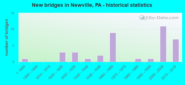
- New bridges - historical statistics
- 1Before 1900
- 31920-1929
- 31930-1939
- 11940-1949
- 21950-1959
- 91960-1969
- 11980-1989
- 11990-1999
- 112000-2009
- 72010-2019

- Reconstructed bridges - Historical Statistics
- 11970-1979
- 01980-1989
- 01990-1999
- 52000-2009


- Bridge Condition - Deck
- 4.2%Excellent
- 8.3%Very good
- 58.3%Good
- 20.8%Satisfactory
- 8.3%Fair

- Bridge Condition - Superstructure
- 40.0%Very good
- 20.0%Good
- 8.0%Satisfactory
- 28.0%Fair
- 4.0%Poor

- Bridge Condition - Substructure
- 16.0%Very good
- 36.0%Good
- 20.0%Satisfactory
- 24.0%Fair
- 4.0%Poor

- Bridge Condition - Channel
- 4.8%Very good
- 23.8%Good
- 33.3%Satisfactory
- 23.8%Fair
- 14.3%Poor

- Bridge Condition - Culverts
- 33.3%Very good
- 16.7%Good
- 16.7%Satisfactory
- 33.3%Fair
Find on map >> Show street view
Structure Number: 6941, Location: PLEASANT VALLEY 02G11 (Lat: 40.527306, Lng: -75.294961), Route carried "on" structure: State highway 212, Year Built: 1928, Status: Open, Structure Length: 0.73m (2.40ft), Average Daily Traffic: 3,604 (year 2021), Truck Traffic: 6%, Average Future Daily Traffic: 3,782 (year 2032), Design Load: H 15, Features Intersected: BRANCH COOKS CREEK, Facility Carried by Structure: QUAKERTOWN ROAD
Minimum Vertical Clearance: 30+ m (98+ ft), Kilometerpoint: 10.979, Lanes on structure: 2, Base Highway Network: Yes, Owner: State Highway Agency, Approaching Roadway Width: 6.4m (21.0ft), Material/Design: Steel, Design/Construction: Stringer/Multi-beam, Number Of Spans In Main Unit: 1, Length of Maximum Span: 6.4m (21.0ft), Curb-To-Curb Width: 7.1m (23.3ft), Out-to-Out Width: 7.9m (25.9ft)
Condition: Deck: Satisfactory, Superstructure: Satisfactory, Substructure: Fair, Channel: Poor, Operating Rating: 68.0 metric tons, Method Used To Determine Operating Rating: Load Factor (LF), Inventory Rating: 40.8 metric tons, Method Used To Determine Inventory Rating: Load Factor (LF), Structural Evaluation: Somewhat better than minimum adequacy, Deck Geometry: High priority of replacement, Waterway Adequacy: Equal to present minimum criteria, Approach Roadway Alignment: Equal to present desirable criteria, Length Of Structure Improvement: 1.30m (4.27ft), Designated Inspection Frequency: Every 24 months, Inspection Date: September 2020, Bridge Improvement Cost: $8,000, Roadway Improvement Cost: $23,000, Total Project Cost: $106,000, Deck Structure Type: Concrete Cast-file-Place, Wearing Surface/Protective System: Wearing Surface: Bituminous
Find on map >> Show street view
Structure Number: 13647, Location: 1.5 MI.S. OF EXIT 37 (Lat: 40.116667, Lng: -77.371667), Route carried "on" structure: State highway , Year Built: 1963, Status: Open, Structure Length: 7.47m (24.51ft), Average Daily Traffic: 199 (year 2022), Truck Traffic: 3%, Average Future Daily Traffic: 494 (year 2032), Design Load: HS 20, Features Intersected: I-81; SR 0081, Facility Carried by Structure: T-346; SMITH RD
Minimum Vertical Clearance: 30+ m (98+ ft), Kilometerpoint: 0.000, Lanes on structure: 2, Lanes under structure: 8, Owner: State Highway Agency, Approaching Roadway Width: 6.1m (20.0ft), Skew: 3 degrees, Material/Design: Prestressed concrete, Design/Construction: Box Beam or Girders - Multiple, Number Of Spans In Main Unit: 2, Number Of Approach Spans: 2, Length of Maximum Span: 24.1m (79.1ft), Curb or Sidewalk Widths: Left: 0.5m (1.6ft), Right: 0.5m (1.6ft), Curb-To-Curb Width: 8.5m (27.9ft), Out-to-Out Width: 10.4m (34.1ft)
Condition: Deck: Good, Superstructure: Good, Substructure: Satisfactory, Operating Rating: 58.1 metric tons, Method Used To Determine Operating Rating: Load Factor (LF), Inventory Rating: 20.9 metric tons, Method Used To Determine Inventory Rating: Load Factor (LF), Structural Evaluation: Equal to present minimum criteria, Deck Geometry: Equal to present minimum criteria, Underclear: Equal to present minimum criteria, Approach Roadway Alignment: Equal to present desirable criteria, Length Of Structure Improvement: 8.40m (27.56ft), Designated Inspection Frequency: Every 24 months, Inspection Date: December 2019, Bridge Improvement Cost: $30,000, Roadway Improvement Cost: $87,000, Total Project Cost: $400,000, Deck Structure Type: Concrete Cast-file-Place, Wearing Surface/Protective System: Wearing Surface: Latex Concrete
Find on map >> Show street view
Structure Number: 13649, Location: NEWVILLE INTERCHANGE (Lat: 40.128658, Lng: -77.350089), Route carried "on" structure: Interstate 81, Year Built: 1963, Status: Open, Structure Length: 3.32m (10.89ft), Average Daily Traffic: 34,704 (year 2020), Truck Traffic: 26%, Average Future Daily Traffic: 28,129 (year 2035), Design Load: HS 20, Features Intersected: PA 233; SR 0233
Minimum Vertical Clearance: 30+ m (98+ ft), Kilometerpoint: 17.255, Lanes on structure: 2, Lanes under structure: 2, Base Highway Network: Yes, Owner: State Highway Agency, Approaching Roadway Width: 12.2m (40.0ft), Skew: 10 degrees, Material/Design: Prestressed concrete, Design/Construction: Box Beam or Girders - Single/Spread, Number Of Spans In Main Unit: 3, Length of Maximum Span: 13.4m (44.0ft), Curb or Sidewalk Widths: Left: 0.2m (0.7ft), Right: 0.2m (0.7ft), Curb-To-Curb Width: 12.3m (40.4ft), Out-to-Out Width: 13.9m (45.6ft)
Condition: Deck: Satisfactory, Superstructure: Fair, Substructure: Fair, Operating Rating: 81.6 metric tons, Method Used To Determine Operating Rating: Load Factor (LF), Inventory Rating: 26.3 metric tons, Method Used To Determine Inventory Rating: Load Factor (LF), Structural Evaluation: Somewhat better than minimum adequacy, Deck Geometry: Better than present minimum criteria, Underclear: Somewhat better than minimum adequacy, Approach Roadway Alignment: Equal to present desirable criteria, Length Of Structure Improvement: 4.20m (13.78ft), Designated Inspection Frequency: Every 24 months, Inspection Date: December 2019, Bridge Improvement Cost: $44,000, Roadway Improvement Cost: $131,000, Total Project Cost: $599,000, Deck Structure Type: Concrete Cast-file-Place, Wearing Surface/Protective System: Wearing Surface: Bituminous
Find on map >> Show street view
Structure Number: 1365, Location: NEWVILLE INTERCHANGE (Lat: 40.128903, Lng: -77.350172), Route carried "on" structure: Interstate 81, Year Built: 1963, Status: Open, Structure Length: 3.29m (10.79ft), Average Daily Traffic: 27,247 (year 2020), Truck Traffic: 28%, Average Future Daily Traffic: 28,207 (year 2035), Design Load: HS 20, Features Intersected: PA 233; SR 0233
Minimum Vertical Clearance: 30+ m (98+ ft), Kilometerpoint: 17.259, Lanes on structure: 2, Lanes under structure: 2, Base Highway Network: Yes, Owner: State Highway Agency, Approaching Roadway Width: 12.2m (40.0ft), Skew: 10 degrees, Material/Design: Prestressed concrete, Design/Construction: Box Beam or Girders - Single/Spread, Number Of Spans In Main Unit: 3, Length of Maximum Span: 13.4m (44.0ft), Curb or Sidewalk Widths: Left: 0.2m (0.7ft), Right: 0.2m (0.7ft), Curb-To-Curb Width: 12.3m (40.4ft), Out-to-Out Width: 13.9m (45.6ft)
Condition: Deck: Fair, Superstructure: Fair, Substructure: Fair, Operating Rating: 81.6 metric tons, Method Used To Determine Operating Rating: Load Factor (LF), Inventory Rating: 32.7 metric tons, Method Used To Determine Inventory Rating: Load Factor (LF), Structural Evaluation: Somewhat better than minimum adequacy, Deck Geometry: Better than present minimum criteria, Underclear: Meets minimum limits, Approach Roadway Alignment: Equal to present desirable criteria, Length Of Structure Improvement: 4.20m (13.78ft), Designated Inspection Frequency: Every 24 months, Inspection Date: December 2019, Bridge Improvement Cost: $44,000, Roadway Improvement Cost: $131,000, Total Project Cost: $599,000, Deck Structure Type: Concrete Cast-file-Place, Wearing Surface/Protective System: Wearing Surface: Bituminous
Find on map >> Show street view
Structure Number: 13738, Location: NEWVILLE BORO (Lat: 40.169597, Lng: -77.397017), Route carried "on" structure: State highway 233, Year Built: 1990, Status: Open, Structure Length: 0.82m (2.69ft), Average Daily Traffic: 5,379 (year 2020), Truck Traffic: 5%, Average Future Daily Traffic: 8,023 (year 2032), Design Load: HS 25 or greater, Features Intersected: BIG SPRING CREEK
Minimum Vertical Clearance: 30+ m (98+ ft), Kilometerpoint: 24.966, Lanes on structure: 2, Base Highway Network: Yes, Owner: State Highway Agency, Approaching Roadway Width: 9.1m (29.9ft), Material/Design: Prestressed concrete, Design/Construction: Box Beam or Girders - Single/Spread, Number Of Spans In Main Unit: 1, Length of Maximum Span: 7.6m (24.9ft), Curb or Sidewalk Widths: Left: 0.2m (0.7ft), Right: 0.2m (0.7ft), Curb-To-Curb Width: 9.1m (29.9ft), Out-to-Out Width: 10.2m (33.5ft)
Condition: Deck: Good, Superstructure: Very good, Substructure: Good, Channel: Satisfactory, Operating Rating: 68.0 metric tons, Method Used To Determine Operating Rating: Load Factor (LF), Inventory Rating: 40.8 metric tons, Method Used To Determine Inventory Rating: Load Factor (LF), Structural Evaluation: Better than present minimum criteria, Deck Geometry: High priority of corrective action, Waterway Adequacy: Better than present minimum criteria, Approach Roadway Alignment: Equal to present desirable criteria, Length Of Structure Improvement: 1.40m (4.59ft), Designated Inspection Frequency: Every 24 months, Inspection Date: Febuary 2020, Deck Structure Type: Concrete Cast-file-Place, Wearing Surface/Protective System: Wearing Surface: Monolithic Concrete, Deck Protection: Epoxy Coated Reinforcing
Find on map >> Show street view
Structure Number: 13747, Location: 1 MI.W. OF NEWVILLE (Lat: 40.163711, Lng: -77.413222), Route carried "on" structure: State highway 533, Year Built: 1969, Status: Open, Structure Length: 7.86m (25.79ft), Average Daily Traffic: 1,132 (year 2021), Truck Traffic: 5%, Average Future Daily Traffic: 2,517 (year 2035), Design Load: HS 20, Features Intersected: CVRT
Minimum Vertical Clearance: 30+ m (98+ ft), Kilometerpoint: 12.450, Lanes on structure: 2, Owner: State Highway Agency, Approaching Roadway Width: 14.3m (46.9ft), Skew: 6 degrees, Material/Design: Prestressed concrete, Design/Construction: Stringer/Multi-beam, Number Of Spans In Main Unit: 3, Length of Maximum Span: 29.0m (95.1ft), Curb or Sidewalk Widths: Left: 0.2m (0.7ft), Right: 0.2m (0.7ft), Curb-To-Curb Width: 13.4m (44.0ft), Out-to-Out Width: 14.6m (47.9ft)
Condition: Deck: Good, Superstructure: Fair, Substructure: Fair, Operating Rating: 65.3 metric tons, Method Used To Determine Operating Rating: Load Factor (LF), Inventory Rating: 22.7 metric tons, Method Used To Determine Inventory Rating: Load Factor (LF), Structural Evaluation: Somewhat better than minimum adequacy, Deck Geometry: Equal to present desirable criteria, Approach Roadway Alignment: Equal to present desirable criteria, Length Of Structure Improvement: 8.80m (28.87ft), Designated Inspection Frequency: Every 24 months, Inspection Date: Febuary 2020, Bridge Improvement Cost: $67,000, Roadway Improvement Cost: $197,000, Total Project Cost: $903,000, Deck Structure Type: Concrete Cast-file-Place, Wearing Surface/Protective System: Wearing Surface: Monolithic Concrete
Find on map >> Show street view
Structure Number: 13775, Location: NEWVILLE (Lat: 40.174608, Lng: -77.395311), Route carried "on" structure: State highway 641, Year Built: 1957, Year Reconstructed: 2012, Status: Open, Structure Length: 1.58m (5.18ft), Average Daily Traffic: 7,174 (year 2022), Truck Traffic: 11%, Average Future Daily Traffic: 10,844 (year 2032), Design Load: HS 20, Features Intersected: BIG SPRING CREEK
Minimum Vertical Clearance: 30+ m (98+ ft), Kilometerpoint: 16.591, Lanes on structure: 2, Base Highway Network: Yes, Owner: State Highway Agency, Approaching Roadway Width: 11.3m (37.1ft), Skew: 1 degrees, Material/Design: Prestressed concrete, Design/Construction: Slab, Number Of Spans In Main Unit: 2, Length of Maximum Span: 7.6m (24.9ft), Curb or Sidewalk Widths: Left: 0.0m, Right: 1.8m (5.9ft), Curb-To-Curb Width: 11.3m (37.1ft), Out-to-Out Width: 13.9m (45.6ft)
Condition: Deck: Good, Superstructure: Very good, Substructure: Satisfactory, Channel: Good, Inventory Rating: 99.8 metric tons, Method Used To Determine Inventory Rating: Load Factor (LF), Structural Evaluation: Equal to present minimum criteria, Deck Geometry: Meets minimum limits, Waterway Adequacy: Equal to present desirable criteria, Approach Roadway Alignment: Equal to present desirable criteria, Length Of Structure Improvement: 2.30m (7.55ft), Designated Inspection Frequency: Every 24 months, Inspection Date: Febuary 2020, Bridge Improvement Cost: $8,000, Roadway Improvement Cost: $22,000, Total Project Cost: $103,000, Deck Structure Type: Concrete Cast-file-Place, Wearing Surface/Protective System: Wearing Surface: Monolithic Concrete, Deck Protection: Epoxy Coated Reinforcing
Find on map >> Show street view
Structure Number: 13931, Location: 1 MI.S. OF NEWVILLE (Lat: 40.162314, Lng: -77.405953), Route carried "on" structure: State highway , Year Built: 1890, Status: Posted for load, Structure Length: 1.10m (3.61ft), Average Daily Traffic: 199 (year 2022), Truck Traffic: 7%, Average Future Daily Traffic: 413 (year 2032), Features Intersected: BIG SPRING CREEK, Facility Carried by Structure: SR 3007 BIG SPRG.R
Minimum Vertical Clearance: 30+ m (98+ ft), Kilometerpoint: 8.958, Lanes on structure: 1, Owner: State Highway Agency, Approaching Roadway Width: 5.2m (17.1ft), Material/Design: Masonry, Design/Construction: Arch - Deck, Number Of Spans In Main Unit: 2, Length of Maximum Span: 4.6m (15.1ft), Curb-To-Curb Width: 4.5m (14.8ft), Out-to-Out Width: 5.5m (18.0ft)
Condition: Superstructure: Poor, Substructure: Poor, Channel: Satisfactory, Operating Rating: 43.5 metric tons, Method Used To Determine Operating Rating: Field evaluation and documented engineering judgment, Inventory Rating: 26.3 metric tons, Method Used To Determine Inventory Rating: Field evaluation and documented engineering judgment, Structural Evaluation: Meets minimum limits, Deck Geometry: High priority of replacement, Waterway Adequacy: Better than present minimum criteria, Approach Roadway Alignment: Equal to present desirable criteria, Length Of Structure Improvement: 1.70m (5.58ft), Designated Inspection Frequency: Every 24 months, Other Special Inspection Frequency: Every 12 months, Inspection Date: April 2020, Other Special Inspection Date: April 2021, Bridge Improvement Cost: $25,000, Roadway Improvement Cost: $75,000, Total Project Cost: $342,000
Find on map >> Show street view
Structure Number: 13962, Location: WASHINGTON (Lat: 40.207247, Lng: -77.430250), Route carried "on" structure: State highway , Year Built: 1927, Status: Open, Structure Length: 0.98m (3.22ft), Average Daily Traffic: 575 (year 2022), Truck Traffic: 5%, Average Future Daily Traffic: 1,938 (year 2032), Design Load: H 15, Features Intersected: CENTER CREEK, Facility Carried by Structure: SR 4008
Minimum Vertical Clearance: 30+ m (98+ ft), Kilometerpoint: 2.501, Lanes on structure: 2, Owner: State Highway Agency, Approaching Roadway Width: 7.3m (24.0ft), Skew: 4 degrees, Material/Design: Steel, Design/Construction: Stringer/Multi-beam, Number Of Spans In Main Unit: 1, Length of Maximum Span: 9.1m (29.9ft), Curb or Sidewalk Widths: Left: 0.1m (0.3ft), Right: 0.1m (0.3ft), Curb-To-Curb Width: 5.3m (17.4ft), Out-to-Out Width: 6.1m (20.0ft)
Condition: Deck: Good, Superstructure: Fair, Substructure: Fair, Channel: Satisfactory, Operating Rating: 96.2 metric tons, Method Used To Determine Operating Rating: Load Factor (LF), Inventory Rating: 57.2 metric tons, Method Used To Determine Inventory Rating: Load Factor (LF), Structural Evaluation: Somewhat better than minimum adequacy, Deck Geometry: High priority of replacement, Waterway Adequacy: Better than present minimum criteria, Approach Roadway Alignment: Somewhat better than minimum adequacy, Length Of Structure Improvement: 1.30m (4.27ft), Designated Inspection Frequency: Every 24 months, Inspection Date: Febuary 2020, Bridge Improvement Cost: $38,000, Roadway Improvement Cost: $229,000, Total Project Cost: $511,000, Deck Structure Type: Concrete Cast-file-Place, Wearing Surface/Protective System: Wearing Surface: Bituminous
Find on map >> Show street view
Structure Number: 13963, Location: 0.3 MI.N.OF NEWVILLE (Lat: 40.199050, Lng: -77.417258), Route carried "on" structure: State highway , Year Built: 1926, Status: Open, Structure Length: 2.13m (6.99ft), Average Daily Traffic: 575 (year 2022), Truck Traffic: 5%, Average Future Daily Traffic: 1,938 (year 2032), Design Load: H 15, Features Intersected: DOUBLING GAP CREEK, Facility Carried by Structure: SR 4008 CENTER RD.
Minimum Vertical Clearance: 30+ m (98+ ft), Kilometerpoint: 4.538, Lanes on structure: 2, Owner: State Highway Agency, Approaching Roadway Width: 7.3m (24.0ft), Skew: 4 degrees, Material/Design: Steel, Design/Construction: Stringer/Multi-beam, Number Of Spans In Main Unit: 2, Length of Maximum Span: 9.1m (29.9ft), Curb or Sidewalk Widths: Left: 0.2m (0.7ft), Right: 0.2m (0.7ft), Curb-To-Curb Width: 5.2m (17.1ft), Out-to-Out Width: 6.2m (20.3ft)
Condition: Deck: Fair, Superstructure: Fair, Substructure: Fair, Channel: Fair, Operating Rating: 49.0 metric tons, Method Used To Determine Operating Rating: Load Factor (LF), Inventory Rating: 32.7 metric tons, Method Used To Determine Inventory Rating: Load Factor (LF), Structural Evaluation: Somewhat better than minimum adequacy, Deck Geometry: High priority of replacement, Waterway Adequacy: Better than present minimum criteria, Approach Roadway Alignment: Somewhat better than minimum adequacy, Length Of Structure Improvement: 2.70m (8.86ft), Designated Inspection Frequency: Every 24 months, Inspection Date: Febuary 2020, Bridge Improvement Cost: $52,000, Roadway Improvement Cost: $207,000, Total Project Cost: $701,000, Deck Structure Type: Concrete Cast-file-Place, Wearing Surface/Protective System: Wearing Surface: Bituminous
Find on map >> Show street view
Structure Number: 13972, Location: .5 MI. N. OF CARLISLE (Lat: 40.224997, Lng: -77.190242), Route carried "on" structure: State highway , Year Built: 1954, Year Reconstructed: 2013, Status: Open, Structure Length: 10.82m (35.50ft), Average Daily Traffic: 2,539 (year 2021), Truck Traffic: 2%, Average Future Daily Traffic: 4,116 (year 2032), Design Load: HS 20, Features Intersected: CONODOGUINET CREEK, Facility Carried by Structure: SR 4029; T-505
Minimum Vertical Clearance: 30+ m (98+ ft), Kilometerpoint: 0.000, Lanes on structure: 2, Owner: State Highway Agency, Approaching Roadway Width: 7.9m (25.9ft), Skew: 3 degrees, Material/Design: Steel continuous, Design/Construction: Stringer/Multi-beam, Number Of Spans In Main Unit: 4, Length of Maximum Span: 29.6m (97.1ft), Curb or Sidewalk Widths: Left: 1.5m (4.9ft), Right: 0.0m, Curb-To-Curb Width: 7.9m (25.9ft), Out-to-Out Width: 10.4m (34.1ft)
Condition: Deck: Very good, Superstructure: Good, Substructure: Satisfactory, Channel: Good, Operating Rating: 44.5 metric tons, Method Used To Determine Operating Rating: Load Factor (LF), Inventory Rating: 27.2 metric tons, Method Used To Determine Inventory Rating: Load Factor (LF), Structural Evaluation: Equal to present minimum criteria, Deck Geometry: High priority of corrective action, Waterway Adequacy: Better than present minimum criteria, Approach Roadway Alignment: Better than present minimum criteria, Length Of Structure Improvement: 11.80m (38.71ft), Designated Inspection Frequency: Every 24 months, Inspection Date: April 2020, Bridge Improvement Cost: $78,000, Roadway Improvement Cost: $229,000, Total Project Cost: $1,050,000, Deck Structure Type: Concrete Cast-file-Place, Wearing Surface/Protective System: Wearing Surface: Monolithic Concrete, Deck Protection: Epoxy Coated Reinforcing
Find on map >> Show street view
Structure Number: 13985, Location: LOWER MIFFLIN TWP (Lat: 40.191667, Lng: -77.420000), Route carried "on" structure: Interstate 76, Year Built: 1938, Year Reconstructed: 2009, Status: Open, Structure Length: 1.19m (3.90ft), Average Daily Traffic: 21,102 (year 2001), Truck Traffic: 38%, Average Future Daily Traffic: 23,285 (year 2030), Design Load: HS 20, Features Intersected: BACK & CENTER CREEK
Minimum Vertical Clearance: 30+ m (98+ ft), Kilometerpoint: 0.000, Lanes on structure: 6, Base Highway Network: Yes, Toll: On toll road, Owner: State Toll Authority, Approaching Roadway Width: 23.8m (78.1ft), Skew: 31 degrees, Material/Design: Concrete, Design/Construction: Culvert, Number Of Spans In Main Unit: 1, Length of Maximum Span: 8.5m (27.9ft)
Condition: Channel: Good, Culverts: Fair, Operating Rating: 89.8 metric tons, Method Used To Determine Operating Rating: Assigned ratings based on Load and Resistance Factor Design (LRFD) reported in metric tons, Inventory Rating: 32.7 metric tons, Method Used To Determine Inventory Rating: Assigned ratings based on Load and Resistance Factor Design (LRFD) reported in metric tons, Structural Evaluation: Somewhat better than minimum adequacy, Waterway Adequacy: Superior to present desirable criteria, Approach Roadway Alignment: Equal to present desirable criteria, Length Of Structure Improvement: 1.80m (5.91ft), Designated Inspection Frequency: Every 24 months, Inspection Date: January 2021, Bridge Improvement Cost: $30,000, Roadway Improvement Cost: $89,000, Total Project Cost: $406,000
Find on map >> Show street view
Structure Number: 13986, Location: LOWER MIFFLIN TWP (Lat: 40.191667, Lng: -77.418333), Route carried "on" structure: Interstate 76, Year Built: 1938, Year Reconstructed: 2009, Status: Open, Structure Length: 2.74m (8.99ft), Average Daily Traffic: 21,102 (year 2001), Truck Traffic: 38%, Average Future Daily Traffic: 23,285 (year 2030), Design Load: HS 20, Features Intersected: DOUBLING GAP CR
Minimum Vertical Clearance: 30+ m (98+ ft), Kilometerpoint: 0.000, Lanes on structure: 6, Base Highway Network: Yes, Toll: On toll road, Owner: State Toll Authority, Approaching Roadway Width: 23.8m (78.1ft), Skew: 30 degrees, Material/Design: Concrete, Design/Construction: Culvert, Number Of Spans In Main Unit: 2, Length of Maximum Span: 12.2m (40.0ft)
Condition: Channel: Fair, Culverts: Satisfactory, Operating Rating: 89.8 metric tons, Method Used To Determine Operating Rating: Load Factor (LF), Inventory Rating: 89.8 metric tons, Method Used To Determine Inventory Rating: Load Factor (LF), Structural Evaluation: Equal to present minimum criteria, Waterway Adequacy: Superior to present desirable criteria, Approach Roadway Alignment: Equal to present desirable criteria, Length Of Structure Improvement: 3.50m (11.48ft), Designated Inspection Frequency: Every 48 months, Inspection Date: January 2019, Bridge Improvement Cost: $59,000, Roadway Improvement Cost: $174,000, Total Project Cost: $798,000
Find on map >> Show street view
Structure Number: 13992, Location: UPPER FRANKFORD TWP (Lat: 40.202933, Lng: -77.369936), Route carried "on" structure: Interstate 76, Year Built: 1938, Year Reconstructed: 2009, Status: Open, Structure Length: 0.79m (2.59ft), Average Daily Traffic: 21,102 (year 2001), Truck Traffic: 38%, Average Future Daily Traffic: 23,285 (year 2030), Design Load: HS 20, Features Intersected: ROCK RUN CREEK
Minimum Vertical Clearance: 30+ m (98+ ft), Kilometerpoint: 0.000, Lanes on structure: 6, Base Highway Network: Yes, Toll: On toll road, Owner: State Toll Authority, Approaching Roadway Width: 24.4m (80.1ft), Skew: 31 degrees, Material/Design: Concrete, Design/Construction: Culvert, Number Of Spans In Main Unit: 1, Length of Maximum Span: 6.7m (22.0ft)
Condition: Channel: Fair, Culverts: Fair, Operating Rating: 89.8 metric tons, Method Used To Determine Operating Rating: Assigned ratings based on Load and Resistance Factor Design (LRFD) reported in metric tons, Inventory Rating: 89.8 metric tons, Method Used To Determine Inventory Rating: Assigned ratings based on Load and Resistance Factor Design (LRFD) reported in metric tons, Structural Evaluation: Somewhat better than minimum adequacy, Waterway Adequacy: Superior to present desirable criteria, Approach Roadway Alignment: Equal to present desirable criteria, Length Of Structure Improvement: 1.40m (4.59ft), Designated Inspection Frequency: Every 24 months, Inspection Date: January 2021, Bridge Improvement Cost: $24,000, Roadway Improvement Cost: $70,000, Total Project Cost: $321,000
Find on map >> Show street view
Structure Number: 13995, Location: WEST PENNSBORO TWP (Lat: 40.201667, Lng: -77.355000), Route carried "on" structure: City street T427, Year Built: 2005, Status: Open, Structure Length: 4.91m (16.11ft), Average Daily Traffic: 200 (year 1992), Truck Traffic: 6%, Average Future Daily Traffic: 315 (year 2030), Design Load: HL 93, Features Intersected: PA TPK (I-76), Facility Carried by Structure: T-427
Minimum Vertical Clearance: 30+ m (98+ ft), Kilometerpoint: 0.000, Lanes on structure: 2, Lanes under structure: 6, Owner: State Toll Authority, Approaching Roadway Width: 9.8m (32.2ft), Skew: 3 degrees, Material/Design: Prestressed concrete continuous, Design/Construction: Box Beam or Girders - Single/Spread, Number Of Spans In Main Unit: 2, Length of Maximum Span: 24.4m (80.1ft), Curb or Sidewalk Widths: Left: 0.2m (0.7ft), Right: 0.2m (0.7ft), Curb-To-Curb Width: 9.8m (32.2ft), Out-to-Out Width: 10.8m (35.4ft)
Condition: Deck: Good, Superstructure: Very good, Substructure: Good, Operating Rating: 76.2 metric tons, Method Used To Determine Operating Rating: Load and Resistance Factor (LRFR), Inventory Rating: 42.6 metric tons, Method Used To Determine Inventory Rating: Load and Resistance Factor (LRFR), Structural Evaluation: Better than present minimum criteria, Deck Geometry: Better than present minimum criteria, Underclear: Better than present minimum criteria, Approach Roadway Alignment: Better than present minimum criteria, Length Of Structure Improvement: 4.10m (13.45ft), Designated Inspection Frequency: Every 48 months, Inspection Date: January 2019, Bridge Improvement Cost: $19,000, Roadway Improvement Cost: $57,000, Total Project Cost: $261,000, Deck Structure Type: Concrete Cast-file-Place, Wearing Surface/Protective System: Wearing Surface: Monolithic Concrete, Deck Protection: Epoxy Coated Reinforcing
Find on map >> Show street view
Structure Number: 1407, Location: 0.5 MI W OF SR 233 (Lat: 40.192644, Lng: -77.415931), Route carried "on" structure: City street , Year Built: 1940, Year Reconstructed: 1978, Status: Posted for load, Structure Length: 1.07m (3.51ft), Average Daily Traffic: 200 (year 2018), Truck Traffic: 3%, Average Future Daily Traffic: 300 (year 2038), Features Intersected: DOUBLING GAP CREEK, Facility Carried by Structure: CREEKVIEW RD T-399
Minimum Vertical Clearance: 30+ m (98+ ft), Kilometerpoint: 0.000, Lanes on structure: 2, Owner: Town or Township Highway Agency, Approaching Roadway Width: 5.8m (19.0ft), Material/Design: Steel, Design/Construction: Stringer/Multi-beam, Number Of Spans In Main Unit: 1, Length of Maximum Span: 10.1m (33.1ft), Curb-To-Curb Width: 6.3m (20.7ft), Out-to-Out Width: 6.7m (22.0ft)
Condition: Deck: Satisfactory, Superstructure: Fair, Substructure: Satisfactory, Channel: Poor, Operating Rating: 53.5 metric tons, Method Used To Determine Operating Rating: Load Factor (LF), Inventory Rating: 31.8 metric tons, Method Used To Determine Inventory Rating: Load Factor (LF), Structural Evaluation: Somewhat better than minimum adequacy, Deck Geometry: Meets minimum limits, Waterway Adequacy: Equal to present minimum criteria, Approach Roadway Alignment: Better than present minimum criteria, Length Of Structure Improvement: 1.80m (5.91ft), Designated Inspection Frequency: Every 24 months, Other Special Inspection Frequency: Every 12 months, Inspection Date: June 2021, Other Special Inspection Date: June 2021, Deck Structure Type: Concrete Cast-file-Place, Wearing Surface/Protective System: Wearing Surface: Bituminous
Find on map >> Show street view
Structure Number: 14074, Location: 0.15 SW OF SR 233 (Lat: 40.214842, Lng: -77.421800), Route carried "on" structure: City street , Year Built: 1986, Status: Open, Structure Length: 0.91m (2.99ft), Average Daily Traffic: 155 (year 2018), Truck Traffic: 5%, Average Future Daily Traffic: 195 (year 2038), Features Intersected: DOUBLING GAP CREEK, Facility Carried by Structure: ROCK RUN ROAD T421
Minimum Vertical Clearance: 30+ m (98+ ft), Kilometerpoint: 0.000, Lanes on structure: 2, Owner: Town or Township Highway Agency, Approaching Roadway Width: 5.5m (18.0ft), Material/Design: Steel, Design/Construction: Stringer/Multi-beam, Number Of Spans In Main Unit: 1, Length of Maximum Span: 8.8m (28.9ft), Curb-To-Curb Width: 7.2m (23.6ft), Out-to-Out Width: 7.6m (24.9ft)
Condition: Deck: Satisfactory, Superstructure: Fair, Substructure: Good, Channel: Poor, Operating Rating: 94.3 metric tons, Method Used To Determine Operating Rating: Load Factor (LF), Inventory Rating: 56.2 metric tons, Method Used To Determine Inventory Rating: Load Factor (LF), Structural Evaluation: Somewhat better than minimum adequacy, Deck Geometry: Meets minimum limits, Waterway Adequacy: Equal to present desirable criteria, Approach Roadway Alignment: Somewhat better than minimum adequacy, Length Of Structure Improvement: 1.60m (5.25ft), Designated Inspection Frequency: Every 24 months, Inspection Date: June 2021, Deck Structure Type: Concrete Cast-file-Place, Wearing Surface/Protective System: Wearing Surface: Bituminous
Find on map >> Show street view
Structure Number: 14109, Location: 2NE NWVLLE/CONODOGUINET (Lat: 40.199500, Lng: -77.366200), Route carried "on" structure: City street , Year Built: 1961, Status: Open, Structure Length: 6.61m (21.69ft), Average Daily Traffic: 300 (year 2017), Average Future Daily Traffic: 420 (year 2035), Design Load: H 20, Features Intersected: CONODOGUINET CREEK, Facility Carried by Structure: BRIDGE RD, T-409
Minimum Vertical Clearance: 30+ m (98+ ft), Kilometerpoint: 0.000, Lanes on structure: 2, Owner: County Highway Agency, Approaching Roadway Width: 6.1m (20.0ft), Material/Design: Prestressed concrete, Design/Construction: Stringer/Multi-beam, Number Of Spans In Main Unit: 3, Length of Maximum Span: 22.3m (73.2ft), Curb or Sidewalk Widths: Left: 0.4m (1.3ft), Right: 0.4m (1.3ft), Curb-To-Curb Width: 6.1m (20.0ft), Out-to-Out Width: 7.6m (24.9ft)
Condition: Deck: Satisfactory, Superstructure: Satisfactory, Substructure: Satisfactory, Channel: Fair, Operating Rating: 67.1 metric tons, Method Used To Determine Operating Rating: Load Factor (LF), Inventory Rating: 20.9 metric tons, Method Used To Determine Inventory Rating: Load Factor (LF), Structural Evaluation: Equal to present minimum criteria, Deck Geometry: Meets minimum limits, Waterway Adequacy: Equal to present desirable criteria, Approach Roadway Alignment: Somewhat better than minimum adequacy, Length Of Structure Improvement: 7.60m (24.93ft), Designated Inspection Frequency: Every 24 months, Inspection Date: June 2021, Deck Structure Type: Concrete Cast-file-Place, Wearing Surface/Protective System: Wearing Surface: Bituminous
Find on map >> Show street view
Structure Number: 42259, Location: 2 MI. S. BLOSERVILLE (Lat: 40.212028, Lng: -77.356678), Route carried "on" structure: State highway , Year Built: 2003, Status: Open, Structure Length: 6.98m (22.90ft), Average Daily Traffic: 1,534 (year 2020), Truck Traffic: 6%, Average Future Daily Traffic: 2,374 (year 2032), Design Load: HL 93, Features Intersected: CONODOGUINET CREEK, Facility Carried by Structure: SR 4021
Minimum Vertical Clearance: 30+ m (98+ ft), Kilometerpoint: 2.054, Lanes on structure: 2, Owner: State Highway Agency, Approaching Roadway Width: 9.1m (29.9ft), Material/Design: Prestressed concrete, Design/Construction: Box Beam or Girders - Single/Spread, Number Of Spans In Main Unit: 3, Length of Maximum Span: 22.6m (74.1ft), Curb or Sidewalk Widths: Left: 0.2m (0.7ft), Right: 0.2m (0.7ft), Curb-To-Curb Width: 9.1m (29.9ft), Out-to-Out Width: 10.0m (32.8ft)
Condition: Deck: Good, Superstructure: Very good, Substructure: Very good, Channel: Satisfactory, Operating Rating: 73.5 metric tons, Method Used To Determine Operating Rating: Load and Resistance Factor (LRFR), Inventory Rating: 38.1 metric tons, Method Used To Determine Inventory Rating: Load and Resistance Factor (LRFR), Structural Evaluation: Equal to present desirable criteria, Deck Geometry: Somewhat better than minimum adequacy, Waterway Adequacy: Superior to present desirable criteria, Approach Roadway Alignment: Equal to present desirable criteria, Designated Inspection Frequency: Every 24 months, Inspection Date: Febuary 2020, Deck Structure Type: Concrete Cast-file-Place, Wearing Surface/Protective System: Wearing Surface: Monolithic Concrete, Deck Protection: Epoxy Coated Reinforcing
Find on map >> Show street view
Structure Number: 43223, Location: 2 MI NORTH OF NEWVILLE (Lat: 40.200883, Lng: -77.384969), Route carried "on" structure: State highway , Year Built: 2005, Status: Open, Structure Length: 4.24m (13.91ft), Average Daily Traffic: 575 (year 2022), Truck Traffic: 5%, Average Future Daily Traffic: 1,938 (year 2032), Design Load: HL 93, Features Intersected: PA TURNPIKE (I-76), Facility Carried by Structure: SR4008
Minimum Vertical Clearance: 30+ m (98+ ft), Kilometerpoint: 8.269, Lanes on structure: 2, Lanes under structure: 4, Owner: State Highway Agency, Approaching Roadway Width: 9.1m (29.9ft), Skew: 2 degrees, Material/Design: Prestressed concrete continuous, Design/Construction: Box Beam or Girders - Single/Spread, Number Of Spans In Main Unit: 2, Length of Maximum Span: 20.7m (67.9ft), Curb or Sidewalk Widths: Left: 0.2m (0.7ft), Right: 0.2m (0.7ft), Curb-To-Curb Width: 9.1m (29.9ft), Out-to-Out Width: 10.2m (33.5ft)
Condition: Deck: Very good, Superstructure: Good, Substructure: Good, Operating Rating: 74.4 metric tons, Method Used To Determine Operating Rating: Load and Resistance Factor (LRFR), Inventory Rating: 42.6 metric tons, Method Used To Determine Inventory Rating: Load and Resistance Factor (LRFR), Structural Evaluation: Better than present minimum criteria, Deck Geometry: Equal to present minimum criteria, Underclear: High priority of corrective action, Approach Roadway Alignment: Equal to present desirable criteria, Designated Inspection Frequency: Every 24 months, Inspection Date: Febuary 2020, Deck Structure Type: Concrete Cast-file-Place, Wearing Surface/Protective System: Wearing Surface: Monolithic Concrete, Deck Protection: Epoxy Coated Reinforcing
Find on map >> Show street view
Structure Number: 44204, Location: 1.5 MI E OF SR 533 (Lat: 40.149161, Lng: -77.406717), Route carried "on" structure: City street , Year Built: 2006, Status: Open, Structure Length: 0.64m (2.10ft), Average Daily Traffic: 200 (year 2018), Truck Traffic: 1%, Average Future Daily Traffic: 250 (year 2038), Design Load: HS 20, Features Intersected: BIG SPRING CREEK, Facility Carried by Structure: NEALY ROAD, T-353
Minimum Vertical Clearance: 30+ m (98+ ft), Kilometerpoint: 0.000, Lanes on structure: 2, Owner: Town or Township Highway Agency, Approaching Roadway Width: 7.0m (23.0ft), Skew: 1 degrees, Material/Design: Concrete, Design/Construction: Culvert, Number Of Spans In Main Unit: 1, Length of Maximum Span: 6.4m (21.0ft)
Condition: Channel: Fair, Culverts: Good, Operating Rating: 89.8 metric tons, Method Used To Determine Operating Rating: Load Factor (LF), Inventory Rating: 59.0 metric tons, Method Used To Determine Inventory Rating: Load Factor (LF), Structural Evaluation: Better than present minimum criteria, Waterway Adequacy: Better than present minimum criteria, Approach Roadway Alignment: Equal to present desirable criteria, Designated Inspection Frequency: Every 24 months, Inspection Date: July 2021
Find on map >> Show street view
Structure Number: 44991, Location: Lower Mifflin Township (Lat: 40.193333, Lng: -77.406667), Route carried "on" structure: State highway 233, Year Built: 2008, Status: Open, Structure Length: 4.75m (15.58ft), Average Daily Traffic: 1,274 (year 2022), Truck Traffic: 22%, Average Future Daily Traffic: 1,811 (year 2032), Design Load: HL 93, Features Intersected: PA Turnpike
Minimum Vertical Clearance: 30+ m (98+ ft), Kilometerpoint: 28.041, Lanes on structure: 2, Lanes under structure: 4, Base Highway Network: Yes, Owner: State Highway Agency, Approaching Roadway Width: 7.3m (24.0ft), Material/Design: Prestressed concrete, Design/Construction: Box Beam or Girders - Single/Spread, Number Of Spans In Main Unit: 2, Length of Maximum Span: 23.5m (77.1ft), Curb or Sidewalk Widths: Left: 0.2m (0.7ft), Right: 0.2m (0.7ft), Curb-To-Curb Width: 12.2m (40.0ft), Out-to-Out Width: 13.2m (43.3ft)
Condition: Deck: Good, Superstructure: Good, Substructure: Good, Operating Rating: 77.1 metric tons, Method Used To Determine Operating Rating: Load and Resistance Factor (LRFR), Inventory Rating: 42.6 metric tons, Method Used To Determine Inventory Rating: Load and Resistance Factor (LRFR), Structural Evaluation: Better than present minimum criteria, Deck Geometry: Better than present minimum criteria, Underclear: Somewhat better than minimum adequacy, Approach Roadway Alignment: Better than present minimum criteria, Designated Inspection Frequency: Every 24 months, Inspection Date: March 2020, Deck Structure Type: Concrete Cast-file-Place, Wearing Surface/Protective System: Wearing Surface: Monolithic Concrete, Deck Protection: Epoxy Coated Reinforcing
Find on map >> Show street view
Structure Number: 46468, Location: Upper Mifflin Twp (Lat: 40.192253, Lng: -77.436256), Route carried "on" structure: City street 402, Year Built: 2008, Status: Open, Structure Length: 4.82m (15.81ft), Average Daily Traffic: 880 (year 2010), Truck Traffic: 5%, Average Future Daily Traffic: 1,118 (year 2030), Design Load: HL 93, Features Intersected: PA TPK (I-76)
Minimum Vertical Clearance: 30+ m (98+ ft), Kilometerpoint: 0.000, Lanes on structure: 2, Lanes under structure: 6, Owner: State Toll Authority, Approaching Roadway Width: 9.1m (29.9ft), Material/Design: Prestressed concrete continuous, Design/Construction: Box Beam or Girders - Single/Spread, Number Of Spans In Main Unit: 2, Length of Maximum Span: 23.8m (78.1ft), Curb or Sidewalk Widths: Left: 0.2m (0.7ft), Right: 0.2m (0.7ft), Curb-To-Curb Width: 9.1m (29.9ft), Out-to-Out Width: 10.2m (33.5ft)
Condition: Deck: Good, Superstructure: Very good, Substructure: Good, Operating Rating: 72.6 metric tons, Method Used To Determine Operating Rating: Load and Resistance Factor (LRFR), Inventory Rating: 42.6 metric tons, Method Used To Determine Inventory Rating: Load and Resistance Factor (LRFR), Structural Evaluation: Better than present minimum criteria, Deck Geometry: Equal to present minimum criteria, Underclear: Equal to present desirable criteria, Approach Roadway Alignment: Somewhat better than minimum adequacy, Designated Inspection Frequency: Every 48 months, Inspection Date: January 2019, Deck Structure Type: Concrete Cast-file-Place, Wearing Surface/Protective System: Wearing Surface: Monolithic Concrete, Deck Protection: Epoxy Coated Reinforcing
Find on map >> Show street view
Structure Number: 46472, Location: Lower Mifflin Twp (Lat: 40.195739, Lng: -77.415397), Route carried "on" structure: Interstate 76, Year Built: 2009, Status: Open, Structure Length: 1.58m (5.18ft), Average Daily Traffic: 21,473 (year 2010), Truck Traffic: 31%, Average Future Daily Traffic: 22,982 (year 2030), Design Load: HL 93, Features Intersected: SR 4008, LR21036
Minimum Vertical Clearance: 30+ m (98+ ft), Kilometerpoint: 341.648, Lanes on structure: 6, Lanes under structure: 2, Base Highway Network: Yes, Toll: On toll road, Owner: State Toll Authority, Approaching Roadway Width: 35.1m (115.2ft), Skew: 31 degrees, Material/Design: Prestressed concrete, Design/Construction: Box Beam or Girders - Single/Spread, Number Of Spans In Main Unit: 1, Length of Maximum Span: 15.8m (51.8ft), Curb or Sidewalk Widths: Left: 0.2m (0.7ft), Right: 0.2m (0.7ft), Curb-To-Curb Width: 35.1m (115.2ft), Out-to-Out Width: 37.0m (121.4ft)
Condition: Deck: Good, Superstructure: Very good, Substructure: Good, Operating Rating: 88.9 metric tons, Method Used To Determine Operating Rating: Load Factor (LF), Inventory Rating: 43.5 metric tons, Method Used To Determine Inventory Rating: Load Factor (LF), Structural Evaluation: Better than present minimum criteria, Deck Geometry: Superior to present desirable criteria, Underclear: Equal to present minimum criteria, Approach Roadway Alignment: Equal to present desirable criteria, Designated Inspection Frequency: Every 48 months, Inspection Date: January 2019, Deck Structure Type: Concrete Cast-file-Place, Wearing Surface/Protective System: Wearing Surface: Monolithic Concrete, Deck Protection: Epoxy Coated Reinforcing
Find on map >> Show street view
Structure Number: 46473, Location: One Mile E Newville MTC (Lat: 40.201667, Lng: -77.356667), Route carried "on" structure: Other road 76, Year Built: 2009, Status: Open, Structure Length: 7.62m (25.00ft), Average Daily Traffic: 21,474 (year 2010), Truck Traffic: 31%, Average Future Daily Traffic: 22,983 (year 2030), Design Load: HL 93, Features Intersected: Conodoguinet Creek
Minimum Vertical Clearance: 30+ m (98+ ft), Kilometerpoint: 0.000, Lanes on structure: 6, Base Highway Network: Yes, Toll: On toll road, Owner: State Toll Authority, Approaching Roadway Width: 35.1m (115.2ft), Skew: 30 degrees, Material/Design: Prestressed concrete continuous, Design/Construction: Stringer/Multi-beam, Number Of Spans In Main Unit: 2, Length of Maximum Span: 37.8m (124.0ft), Curb or Sidewalk Widths: Left: 0.2m (0.7ft), Right: 0.2m (0.7ft), Curb-To-Curb Width: 35.1m (115.2ft), Out-to-Out Width: 37.0m (121.4ft)
Condition: Deck: Good, Superstructure: Good, Substructure: Good, Channel: Satisfactory, Operating Rating: 79.8 metric tons, Method Used To Determine Operating Rating: Load Factor (LF), Inventory Rating: 25.4 metric tons, Method Used To Determine Inventory Rating: Load Factor (LF), Structural Evaluation: Equal to present minimum criteria, Deck Geometry: Superior to present desirable criteria, Waterway Adequacy: Superior to present desirable criteria, Approach Roadway Alignment: Equal to present desirable criteria, Designated Inspection Frequency: Every 24 months, Inspection Date: January 2021, Deck Structure Type: Concrete Cast-file-Place, Wearing Surface/Protective System: Wearing Surface: Monolithic Concrete, Deck Protection: Epoxy Coated Reinforcing
Find on map >> Show street view
Structure Number: 47526, Location: 3 MI.S. OF NEWVILLE (Lat: 40.130444, Lng: -77.407700), Route carried "on" structure: State highway , Year Built: 2012, Status: Open, Structure Length: 1.77m (5.81ft), Average Daily Traffic: 199 (year 2022), Truck Traffic: 7%, Average Future Daily Traffic: 413 (year 2032), Design Load: HL 93, Features Intersected: BIG SPRING RUN, Facility Carried by Structure: SR 3007 BIG SPRING
Minimum Vertical Clearance: 30.45m (99.90ft), Kilometerpoint: 5.057, Lanes on structure: 2, Owner: State Highway Agency, Approaching Roadway Width: 7.3m (24.0ft), Skew: 1 degrees, Material/Design: Prestressed concrete, Design/Construction: Box Beam or Girders - Single/Spread, Number Of Spans In Main Unit: 1, Length of Maximum Span: 17.1m (56.1ft), Curb-To-Curb Width: 7.8m (25.6ft), Out-to-Out Width: 8.7m (28.5ft)
Condition: Deck: Good, Superstructure: Very good, Substructure: Very good, Channel: Good, Operating Rating: 61.9 metric tons, Method Used To Determine Operating Rating: Assigned ratings based on Load and Resistance Factor Design (LRFD) reported by rating factor (RF) using HL93 loadings, Inventory Rating: 38.9 metric tons, Method Used To Determine Inventory Rating: Assigned ratings based on Load and Resistance Factor Design (LRFD) reported by rating factor (RF) using HL93 loadings, Structural Evaluation: Equal to present desirable criteria, Deck Geometry: Somewhat better than minimum adequacy, Waterway Adequacy: Better than present minimum criteria, Approach Roadway Alignment: Better than present minimum criteria, Designated Inspection Frequency: Every 48 months, Inspection Date: November 2019, Deck Structure Type: Concrete Cast-file-Place, Wearing Surface/Protective System: Wearing Surface: Monolithic Concrete, Deck Protection: Epoxy Coated Reinforcing
Find on map >> Show street view
Structure Number: 48535, Location: 3 MI SW OF NEWVILLE (Lat: 40.159419, Lng: -77.448583), Route carried "on" structure: State highway 641, Year Built: 2013, Status: Open, Structure Length: 2.44m (8.01ft), Average Daily Traffic: 3,174 (year 2022), Truck Traffic: 6%, Average Future Daily Traffic: 3,410 (year 2032), Design Load: HL 93, Features Intersected: BULLS HEAD CREEK
Minimum Vertical Clearance: 30+ m (98+ ft), Kilometerpoint: 11.351, Lanes on structure: 2, Owner: State Highway Agency, Approaching Roadway Width: 9.1m (29.9ft), Skew: 1 degrees, Material/Design: Prestressed concrete, Design/Construction: Box Beam or Girders - Single/Spread, Number Of Spans In Main Unit: 1, Length of Maximum Span: 14.3m (46.9ft), Curb-To-Curb Width: 9.1m (29.9ft), Out-to-Out Width: 10.1m (33.1ft)
Condition: Deck: Good, Superstructure: Very good, Substructure: Very good, Channel: Very good, Operating Rating: 66.4 metric tons, Method Used To Determine Operating Rating: Assigned ratings based on Load and Resistance Factor Design (LRFD) reported by rating factor (RF) using HL93 loadings, Inventory Rating: 38.6 metric tons, Method Used To Determine Inventory Rating: Assigned ratings based on Load and Resistance Factor Design (LRFD) reported by rating factor (RF) using HL93 loadings, Structural Evaluation: Equal to present desirable criteria, Deck Geometry: Meets minimum limits, Waterway Adequacy: Better than present minimum criteria, Approach Roadway Alignment: Equal to present desirable criteria, Designated Inspection Frequency: Every 24 months, Inspection Date: March 2020, Deck Structure Type: Concrete Cast-file-Place, Wearing Surface/Protective System: Wearing Surface: Monolithic Concrete, Deck Protection: Epoxy Coated Reinforcing
Find on map >> Show street view
Structure Number: 48536, Location: 3 MI. S.W. OF NEWVILLE (Lat: 40.158531, Lng: -77.450114), Route carried "on" structure: State highway 641, Year Built: 2013, Status: Open, Structure Length: 0.79m (2.59ft), Average Daily Traffic: 3,174 (year 2022), Truck Traffic: 6%, Average Future Daily Traffic: 3,410 (year 2032), Design Load: HL 93, Features Intersected: GREEN SPRING CREEK
Minimum Vertical Clearance: 30+ m (98+ ft), Kilometerpoint: 11.351, Lanes on structure: 2, Owner: State Highway Agency, Approaching Roadway Width: 9.1m (29.9ft), Material/Design: Concrete, Design/Construction: Culvert, Number Of Spans In Main Unit: 1, Length of Maximum Span: 7.3m (24.0ft)
Condition: Channel: Good, Culverts: Very good, Operating Rating: 40.5 metric tons, Method Used To Determine Operating Rating: Assigned ratings based on Load and Resistance Factor Design (LRFD) reported by rating factor (RF) using HL93 loadings, Inventory Rating: 32.7 metric tons, Method Used To Determine Inventory Rating: Assigned ratings based on Load and Resistance Factor Design (LRFD) reported by rating factor (RF) using HL93 loadings, Structural Evaluation: Equal to present desirable criteria, Waterway Adequacy: Better than present minimum criteria, Approach Roadway Alignment: Equal to present desirable criteria, Designated Inspection Frequency: Every 24 months, Inspection Date: March 2020
Find on map >> Show street view
Structure Number: 4911, Location: Upper Mifflin Twp. (Lat: 40.188617, Lng: -77.458017), Route carried "on" structure: Interstate 76, Year Built: 2014, Status: Open, Structure Length: 1.98m (6.50ft), Average Daily Traffic: 21,102 (year 2001), Truck Traffic: 38%, Average Future Daily Traffic: 23,285 (year 2030), Design Load: HL 93, Features Intersected: SR 4013
Minimum Vertical Clearance: 30+ m (98+ ft), Kilometerpoint: 0.000, Lanes on structure: 6, Lanes under structure: 2, Base Highway Network: Yes, Toll: On toll road, Owner: State Toll Authority, Approaching Roadway Width: 35.1m (115.2ft), Skew: 33 degrees, Material/Design: Prestressed concrete, Design/Construction: Box Beam or Girders - Single/Spread, Number Of Spans In Main Unit: 1, Length of Maximum Span: 19.2m (63.0ft), Curb or Sidewalk Widths: Left: 0.2m (0.7ft), Right: 0.2m (0.7ft), Curb-To-Curb Width: 34.4m (112.9ft), Out-to-Out Width: 36.9m (121.1ft)
Condition: Deck: Good, Superstructure: Very good, Substructure: Good, Operating Rating: 62.2 metric tons, Method Used To Determine Operating Rating: Assigned ratings based on Load and Resistance Factor Design (LRFD) reported by rating factor (RF) using HL93 loadings, Inventory Rating: 39.2 metric tons, Method Used To Determine Inventory Rating: Assigned ratings based on Load and Resistance Factor Design (LRFD) reported by rating factor (RF) using HL93 loadings, Structural Evaluation: Better than present minimum criteria, Deck Geometry: Superior to present desirable criteria, Underclear: Superior to present desirable criteria, Approach Roadway Alignment: Equal to present desirable criteria, Designated Inspection Frequency: Every 24 months, Inspection Date: January 2021, Deck Structure Type: Concrete Cast-file-Place, Wearing Surface/Protective System: Wearing Surface: Monolithic Concrete, Deck Protection: Epoxy Coated Reinforcing
Find on map >> Show street view
Structure Number: 53755, Location: 0.8 MI NORTH OF NEWVILLE (Lat: 40.184417, Lng: -77.406056), Route carried "on" structure: State highway 233, Year Built: 2018, Status: Open, Structure Length: 7.07m (23.20ft), Average Daily Traffic: 3,349 (year 2022), Truck Traffic: 12%, Average Future Daily Traffic: 5,131 (year 2032), Design Load: HL 93, Features Intersected: CONODOGUINET CREEK, Facility Carried by Structure: Doubling Gap Rd
Minimum Vertical Clearance: 30+ m (98+ ft), Kilometerpoint: 26.337, Lanes on structure: 2, Base Highway Network: Yes, Owner: State Highway Agency, Maintenance Responsibility: Private, Approaching Roadway Width: 7.3m (24.0ft), Material/Design: Prestressed concrete continuous, Design/Construction: Box Beam or Girders - Single/Spread, Number Of Spans In Main Unit: 2, Length of Maximum Span: 35.4m (116.1ft), Curb-To-Curb Width: 12.2m (40.0ft), Out-to-Out Width: 12.8m (42.0ft)
Condition: Deck: Excellent, Superstructure: Very good, Substructure: Very good, Channel: Satisfactory, Operating Rating: 48.0 metric tons, Method Used To Determine Operating Rating: Assigned ratings based on Load and Resistance Factor Design (LRFD) reported by rating factor (RF) using HL93 loadings, Inventory Rating: 36.9 metric tons, Method Used To Determine Inventory Rating: Assigned ratings based on Load and Resistance Factor Design (LRFD) reported by rating factor (RF) using HL93 loadings, Structural Evaluation: Equal to present desirable criteria, Deck Geometry: Equal to present minimum criteria, Waterway Adequacy: Superior to present desirable criteria, Approach Roadway Alignment: Better than present minimum criteria, Designated Inspection Frequency: Every 24 months, Inspection Date: April 2020, Deck Structure Type: Concrete Cast-file-Place, Wearing Surface/Protective System: Wearing Surface: Integral Concrete, Deck Protection: Epoxy Coated Reinforcing
Find on map >> Show street view
Structure Number: 53762, Location: 1.5 MI SE OF SR 997 (Lat: 40.209114, Lng: -77.436561), Route carried "on" structure: State highway , Year Built: 2017, Status: Open, Structure Length: 0.79m (2.59ft), Average Daily Traffic: 575 (year 2022), Truck Traffic: 5%, Average Future Daily Traffic: 1,938 (year 2032), Design Load: HL 93, Features Intersected: BACK CREEK, Facility Carried by Structure: CENTER RD (SR4008)
Minimum Vertical Clearance: 30+ m (98+ ft), Kilometerpoint: 1.830, Lanes on structure: 2, Owner: State Highway Agency, Maintenance Responsibility: Private, Approaching Roadway Width: 7.0m (23.0ft), Material/Design: Concrete, Design/Construction: Culvert, Number Of Spans In Main Unit: 1, Length of Maximum Span: 7.3m (24.0ft), Curb-To-Curb Width: 8.5m (27.9ft), Out-to-Out Width: 9.9m (32.5ft)
Condition: Channel: Satisfactory, Culverts: Very good, Operating Rating: 57.7 metric tons, Method Used To Determine Operating Rating: Assigned ratings based on Load and Resistance Factor Design (LRFD) reported by rating factor (RF) using HL93 loadings, Inventory Rating: 36.3 metric tons, Method Used To Determine Inventory Rating: Assigned ratings based on Load and Resistance Factor Design (LRFD) reported by rating factor (RF) using HL93 loadings, Structural Evaluation: Equal to present desirable criteria, Deck Geometry: Somewhat better than minimum adequacy, Waterway Adequacy: Equal to present desirable criteria, Approach Roadway Alignment: Equal to present desirable criteria, Designated Inspection Frequency: Every 24 months, Inspection Date: November 2021, Wearing Surface/Protective System: Wearing Surface: Bituminous, Membrane: Preformed Fabric
Find on map >> Show street view
Structure Number: 13647, Location: 1.5 MI.S. OF EXIT 37 (Lat: 40.116667, Lng: -77.371667), Route carried "under" structure: Interstate 81, Year Built: 1963, Structure Length: 0. m, Average Daily Traffic: 23,322 (year 2021), Truck Traffic: 29%, Features Intersected: I-81; SR 0081, Facility Carried by Structure: T-346; SMITH RD
Minimum Vertical Clearance: 5.36m (17.59ft), Kilometerpoint: 15.604, Lanes on structure: 2, Lanes under structure: 4, Material/Design: Prestressed concrete, Design/Construction: Box Beam or Girders - Multiple, Length of Maximum Span: 24.1m (79.1ft)
Find on map >> Show street view
Structure Number: 13647, Location: 1.5 MI.S. OF EXIT 37 (Lat: 40.116667, Lng: -77.371667), Route carried "under" structure: Interstate 81, Year Built: 1963, Structure Length: 0. m, Average Daily Traffic: 21,441 (year 2021), Truck Traffic: 33%, Features Intersected: I-81; SR 0081, Facility Carried by Structure: T-346; SMITH RD
Minimum Vertical Clearance: 5.05m (16.57ft), Kilometerpoint: 15.643, Lanes on structure: 2, Lanes under structure: 4, Material/Design: Prestressed concrete, Design/Construction: Box Beam or Girders - Multiple, Length of Maximum Span: 24.1m (79.1ft)
Find on map >> Show street view
Structure Number: 13649, Location: NEWVILLE INTERCHANGE (Lat: 40.128658, Lng: -77.350089), Route carried "under" structure: State highway 233, Year Built: 1963, Structure Length: 0. m, Average Daily Traffic: 7,998 (year 2022), Truck Traffic: 15%, Features Intersected: PA 233; SR 0233, Facility Carried by Structure: I-81 NB; SR 0081
Minimum Vertical Clearance: 4.52m (14.83ft), Kilometerpoint: 18.092, Lanes on structure: 2, Lanes under structure: 2, Material/Design: Prestressed concrete, Design/Construction: Box Beam or Girders - Single/Spread, Length of Maximum Span: 13.4m (44.0ft)
Find on map >> Show street view
Structure Number: 1365, Location: NEWVILLE INTERCHANGE (Lat: 40.128903, Lng: -77.350172), Route carried "under" structure: State highway 233, Year Built: 1963, Structure Length: 0. m, Average Daily Traffic: 7,998 (year 2022), Truck Traffic: 15%, Features Intersected: PA 233; SR 0233, Facility Carried by Structure: I-81 SB; SR 0081
Minimum Vertical Clearance: 4.77m (15.65ft), Kilometerpoint: 18.842, Lanes on structure: 2, Lanes under structure: 2, Material/Design: Prestressed concrete, Design/Construction: Box Beam or Girders - Single/Spread, Length of Maximum Span: 13.4m (44.0ft)
Find on map >> Show street view
Structure Number: 43223, Location: 2 MI NORTH OF NEWVILLE (Lat: 40.200883, Lng: -77.384969), Route carried "under" structure: Interstate 76, Year Built: 2005, Structure Length: 0. m, Features Intersected: PA TURNPIKE (I-76), Facility Carried by Structure: SR4008
Minimum Vertical Clearance: 4.47m (14.67ft), Kilometerpoint: 0.000, Lanes on structure: 2, Lanes under structure: 4, Material/Design: Prestressed concrete continuous, Design/Construction: Box Beam or Girders - Single/Spread, Length of Maximum Span: 20.7m (67.9ft)
Find on map >> Show street view
Structure Number: 44991, Location: Lower Mifflin Township (Lat: 40.193333, Lng: -77.406667), Route carried "under" structure: Interstate 76, Year Built: 2008, Structure Length: 0. m, Average Daily Traffic: 18,892 (year 1997), Truck Traffic: 34%, Features Intersected: PA Turnpike, Facility Carried by Structure: SR 0233 DOUBLING G
Minimum Vertical Clearance: 4.88m (16.01ft), Kilometerpoint: 0.000, Lanes on structure: 2, Lanes under structure: 4, Toll: On toll road, Material/Design: Prestressed concrete, Design/Construction: Box Beam or Girders - Single/Spread, Length of Maximum Span: 23.5m (77.1ft)
Find on map >> Show street view
Structure Number: 46472, Location: Lower Mifflin Twp (Lat: 40.195739, Lng: -77.415397), Route carried "under" structure: Business State highway , Year Built: 2009, Structure Length: 0. m, Average Daily Traffic: 575 (year 2022), Truck Traffic: 5%, Features Intersected: SR 4008, LR21036, Facility Carried by Structure: PA TPK (I-76)
Minimum Vertical Clearance: 4.93m (16.17ft), Kilometerpoint: 4.538, Lanes on structure: 6, Lanes under structure: 2, Material/Design: Prestressed concrete, Design/Construction: Box Beam or Girders - Single/Spread, Length of Maximum Span: 15.8m (51.8ft)
Find on map >> Show street view
Structure Number: 4911, Location: Upper Mifflin Twp. (Lat: 40.188617, Lng: -77.458017), Route carried "under" structure: State highway , Year Built: 2014, Structure Length: 0. m, Average Daily Traffic: 845 (year 2020), Truck Traffic: 15%, Features Intersected: SR 4013, Facility Carried by Structure: PA TPK (I76)
Minimum Vertical Clearance: 5.39m (17.68ft), Kilometerpoint: 0.518, Lanes on structure: 6, Lanes under structure: 2, Material/Design: Prestressed concrete, Design/Construction: Box Beam or Girders - Single/Spread, Length of Maximum Span: 19.2m (63.0ft)