Bridge Statistics for North Mankato, Minnesota (MN)
Condition, Traffic, Stress, Structural Evaluation, Project Costs
- National Bridge Inventory (NBI) Statistics
- 28Number of bridges
- 184ft / 56.2mTotal length
- $75,000,000Total costs
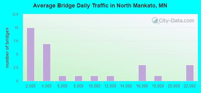
- 177,373Total average daily traffic
- 12,131Total average daily truck traffic
- National Bridge Inventory (NBI) Registered Bridges for North Mankato
- No street view available for this location
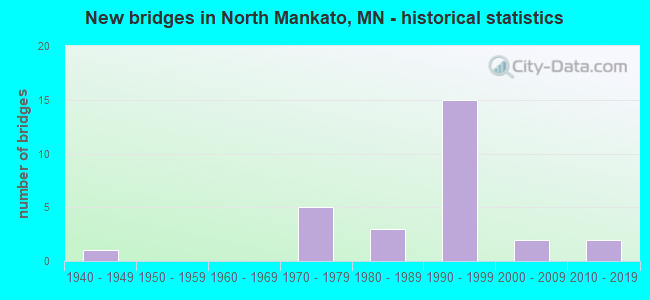
- New bridges - historical statistics
- 11940-1949
- 51970-1979
- 31980-1989
- 151990-1999
- 22000-2009
- 22010-2019
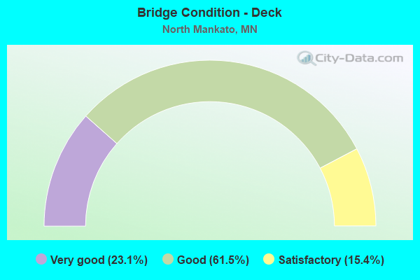
- Bridge Condition - Deck
- 23.1%Very good
- 61.5%Good
- 15.4%Satisfactory
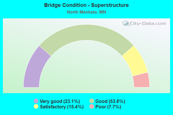
- Bridge Condition - Superstructure
- 23.1%Very good
- 53.8%Good
- 15.4%Satisfactory
- 7.7%Poor
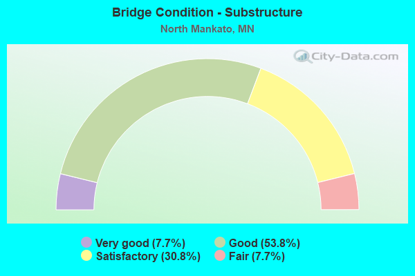
- Bridge Condition - Substructure
- 7.7%Very good
- 53.8%Good
- 30.8%Satisfactory
- 7.7%Fair
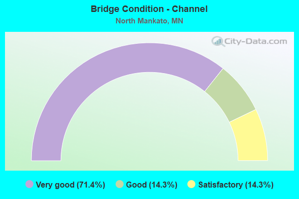
- Bridge Condition - Channel
- 71.4%Very good
- 14.3%Good
- 14.3%Satisfactory
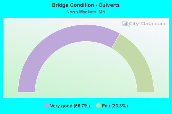
- Bridge Condition - Culverts
- 66.7%Very good
- 33.3%Fair
Find on map >> Show street view
Structure Number: 7043, Location: 1.8 MI E OF JCT TH 60 (Lat: 44.145522, Lng: -94.084053), Route carried "on" structure: US 169, Year Built: 1997, Status: Open, Structure Length: 4.57m (14.99ft), Average Daily Traffic: 16,250 (year 2016), Truck Traffic: 11%, Average Future Daily Traffic: 16,250 (year 2039), Design Load: HS 25 or greater, Features Intersected: CSAH 90 WB
Minimum Vertical Clearance: 30+ m (98+ ft), Kilometerpoint: 0.000, Lanes on structure: 3, Lanes under structure: 1, Base Highway Network: Yes, Owner: State Highway Agency, Approaching Roadway Width: 14.3m (46.9ft), Skew: 3 degrees, Material/Design: Prestressed concrete, Design/Construction: Stringer/Multi-beam, Number Of Spans In Main Unit: 1, Length of Maximum Span: 42.7m (140.1ft), Curb-To-Curb Width: 16.5m (54.1ft), Out-to-Out Width: 17.5m (57.4ft)
Condition: Deck: Good, Superstructure: Good, Substructure: Satisfactory, Operating Rating: 90.0 metric tons, Method Used To Determine Operating Rating: Load Factor (LF), Inventory Rating: 45.4 metric tons, Method Used To Determine Inventory Rating: Load Factor (LF), Structural Evaluation: Equal to present minimum criteria, Deck Geometry: Better than present minimum criteria, Underclear: Better than present minimum criteria, Approach Roadway Alignment: Equal to present desirable criteria, Designated Inspection Frequency: Every 24 months, Inspection Date: July 2020, Deck Structure Type: Concrete Cast-file-Place, Wearing Surface/Protective System: Wearing Surface: Low Slump Concrete, Deck Protection: Epoxy Coated Reinforcing
Find on map >> Show street view
Structure Number: 7044, Location: 1.8 MI E OF JCT TH 60 (Lat: 44.145428, Lng: -94.083467), Route carried "on" structure: US 169, Year Built: 1997, Status: Open, Structure Length: 3.80m (12.47ft), Average Daily Traffic: 7,700 (year 2019), Truck Traffic: 15%, Average Future Daily Traffic: 16,250 (year 2039), Design Load: HS 25 or greater, Features Intersected: CSAH 90 WB
Minimum Vertical Clearance: 30+ m (98+ ft), Kilometerpoint: 0.000, Lanes on structure: 3, Lanes under structure: 1, Base Highway Network: Yes, Owner: State Highway Agency, Approaching Roadway Width: 13.7m (44.9ft), Skew: 4 degrees, Material/Design: Prestressed concrete, Design/Construction: Stringer/Multi-beam, Number Of Spans In Main Unit: 1, Length of Maximum Span: 35.6m (116.8ft), Curb-To-Curb Width: 14.9m (48.9ft), Out-to-Out Width: 15.9m (52.2ft)
Condition: Deck: Good, Superstructure: Good, Substructure: Satisfactory, Operating Rating: 66.3 metric tons, Method Used To Determine Operating Rating: Load Factor (LF), Inventory Rating: 43.7 metric tons, Method Used To Determine Inventory Rating: Load Factor (LF), Structural Evaluation: Equal to present minimum criteria, Deck Geometry: Equal to present minimum criteria, Underclear: Better than present minimum criteria, Approach Roadway Alignment: Equal to present desirable criteria, Designated Inspection Frequency: Every 24 months, Inspection Date: July 2020, Deck Structure Type: Concrete Cast-file-Place, Wearing Surface/Protective System: Wearing Surface: Low Slump Concrete, Deck Protection: Epoxy Coated Reinforcing
Find on map >> Show street view
Structure Number: 757, Location: 0.6 MI NE OF JCT TH 169 (Lat: 44.148628, Lng: -94.103828), Route carried "on" structure: County highway 69, Year Built: 1995, Status: Open, Structure Length: 2.06m (6.76ft), Average Daily Traffic: 130 (year 2017), Average Future Daily Traffic: 130 (year 2039), Design Load: HS 25 or greater, Features Intersected: MINNEOPA CREEK
Minimum Vertical Clearance: 30+ m (98+ ft), Kilometerpoint: 0.000, Lanes on structure: 2, Owner: County Highway Agency, Approaching Roadway Width: 11.0m (36.1ft), Skew: 1 degrees, Material/Design: Prestressed concrete, Design/Construction: Stringer/Multi-beam, Number Of Spans In Main Unit: 1, Length of Maximum Span: 20.1m (65.9ft), Curb-To-Curb Width: 11.0m (36.1ft), Out-to-Out Width: 12.0m (39.4ft)
Condition: Deck: Very good, Superstructure: Very good, Substructure: Very good, Channel: Very good, Operating Rating: 63.0 metric tons, Method Used To Determine Operating Rating: Load Factor (LF), Inventory Rating: 37.7 metric tons, Method Used To Determine Inventory Rating: Load Factor (LF), Structural Evaluation: Equal to present desirable criteria, Deck Geometry: Equal to present desirable criteria, Waterway Adequacy: Equal to present desirable criteria, Approach Roadway Alignment: Equal to present desirable criteria, Designated Inspection Frequency: Every 24 months, Inspection Date: September 2021, Deck Structure Type: Concrete Cast-file-Place, Wearing Surface/Protective System: Wearing Surface: Monolithic Concrete, Deck Protection: Epoxy Coated Reinforcing
Find on map >> Show street view
Structure Number: 7572, Location: 0.9 MI SW OF JCT TH 169 (Lat: 44.148133, Lng: -94.095917), Route carried "on" structure: ServiceState lands road 7, Year Built: 1998, Status: Open, Structure Length: 1.60m (5.25ft), Average Daily Traffic: 180 (year 2001), Average Future Daily Traffic: 180 (year 2029), Design Load: HS 25 or greater, Features Intersected: MINNEOPA CREEK
Minimum Vertical Clearance: 30+ m (98+ ft), Kilometerpoint: 0.000, Lanes on structure: 2, Owner: State Agenciy, Approaching Roadway Width: 7.9m (25.9ft), Material/Design: Concrete, Design/Construction: Slab, Number Of Spans In Main Unit: 1, Length of Maximum Span: 15.2m (49.9ft), Curb-To-Curb Width: 9.3m (30.5ft), Out-to-Out Width: 9.3m (30.5ft)
Condition: Deck: Very good, Superstructure: Good, Substructure: Good, Channel: Very good, Operating Rating: 77.7 metric tons, Method Used To Determine Operating Rating: Load Factor (LF), Inventory Rating: 46.5 metric tons, Method Used To Determine Inventory Rating: Load Factor (LF), Structural Evaluation: Better than present minimum criteria, Deck Geometry: Equal to present minimum criteria, Waterway Adequacy: Equal to present desirable criteria, Approach Roadway Alignment: Better than present minimum criteria, Designated Inspection Frequency: Every 24 months, Inspection Date: September 2021, Deck Structure Type: Concrete Cast-file-Place, Wearing Surface/Protective System: Wearing Surface: Monolithic Concrete, Deck Protection: Epoxy Coated Reinforcing
Find on map >> Show street view
Structure Number: 52003, Location: 0.8 MI W JCT LOR RAY DR (Lat: 44.186150, Lng: -94.068419), Route carried "on" structure: County highway 41, Year Built: 2013, Status: Open, Structure Length: 6.96m (22.83ft), Average Daily Traffic: 5,000 (year 2015), Average Future Daily Traffic: 5,000 (year 2039), Design Load: HL 93, Features Intersected: US 14
Minimum Vertical Clearance: 30+ m (98+ ft), Kilometerpoint: 0.000, Lanes on structure: 3, Lanes under structure: 5, Owner: State Highway Agency, Approaching Roadway Width: 14.0m (45.9ft), Skew: 20 degrees, Material/Design: Prestressed concrete, Design/Construction: Stringer/Multi-beam, Number Of Spans In Main Unit: 2, Length of Maximum Span: 35.4m (116.1ft), Curb or Sidewalk Widths: Left: 0.0m, Right: 3.5m (11.5ft), Curb-To-Curb Width: 17.1m (56.1ft), Out-to-Out Width: 22.0m (72.2ft)
Condition: Deck: Satisfactory, Superstructure: Very good, Substructure: Good, Operating Rating: 66.1 metric tons, Method Used To Determine Operating Rating: Load and Resistance Factor Rating (LRFR) rating reported by rating factor(RF) method using HL-93 loadings, Inventory Rating: 36.3 metric tons, Method Used To Determine Inventory Rating: Load and Resistance Factor Rating (LRFR) rating reported by rating factor(RF) method using HL-93 loadings, Structural Evaluation: Better than present minimum criteria, Deck Geometry: Superior to present desirable criteria, Underclear: Better than present minimum criteria, Approach Roadway Alignment: Equal to present desirable criteria, Designated Inspection Frequency: Every 24 months, Inspection Date: April 2020, Deck Structure Type: Concrete Cast-file-Place, Wearing Surface/Protective System: Wearing Surface: Low Slump Concrete, Deck Protection: Epoxy Coated Reinforcing
Find on map >> Show street view
Structure Number: 52006, Location: 2.2 MI W OF JCT TH 169 (Lat: 44.181011, Lng: -94.053725), Route carried "on" structure: City street 116, Year Built: 1974, Status: Open, Structure Length: 9.45m (31.00ft), Average Daily Traffic: 8,000 (year 2011), Average Future Daily Traffic: 8,000 (year 2039), Design Load: HS 20, Features Intersected: US 14
Minimum Vertical Clearance: 30+ m (98+ ft), Kilometerpoint: 0.000, Lanes on structure: 4, Lanes under structure: 4, Owner: State Highway Agency, Approaching Roadway Width: 31.7m (104.0ft), Skew: 20 degrees, Material/Design: Prestressed concrete, Design/Construction: Stringer/Multi-beam, Number Of Spans In Main Unit: 4, Length of Maximum Span: 29.5m (96.8ft), Curb or Sidewalk Widths: Left: 0.0m, Right: 1.8m (5.9ft), Curb-To-Curb Width: 29.6m (97.1ft), Out-to-Out Width: 34.3m (112.5ft)
Condition: Deck: Good, Superstructure: Satisfactory, Substructure: Satisfactory, Operating Rating: 74.5 metric tons, Method Used To Determine Operating Rating: Load Factor (LF), Inventory Rating: 34.1 metric tons, Method Used To Determine Inventory Rating: Load Factor (LF), Structural Evaluation: Equal to present minimum criteria, Deck Geometry: Superior to present desirable criteria, Underclear: Equal to present minimum criteria, Approach Roadway Alignment: Equal to present desirable criteria, Designated Inspection Frequency: Every 24 months, Inspection Date: June 2021, Deck Structure Type: Concrete Cast-file-Place, Wearing Surface/Protective System: Wearing Surface: Low Slump Concrete
Find on map >> Show street view
Structure Number: 52007, Location: 1.2 MI W OF JCT TH 169 (Lat: 44.181197, Lng: -94.035469), Route carried "on" structure: City street 117, Year Built: 1974, Status: Open, Structure Length: 9.21m (30.22ft), Average Daily Traffic: 15,100 (year 2011), Average Future Daily Traffic: 15,100 (year 2039), Design Load: HS 20, Features Intersected: US 14
Minimum Vertical Clearance: 30+ m (98+ ft), Kilometerpoint: 0.000, Lanes on structure: 4, Lanes under structure: 4, Owner: State Highway Agency, Approaching Roadway Width: 28.0m (91.9ft), Skew: 24 degrees, Material/Design: Prestressed concrete, Design/Construction: Stringer/Multi-beam, Number Of Spans In Main Unit: 4, Length of Maximum Span: 27.8m (91.2ft), Curb or Sidewalk Widths: Left: 1.8m (5.9ft), Right: 1.8m (5.9ft), Curb-To-Curb Width: 25.6m (84.0ft), Out-to-Out Width: 32.4m (106.3ft)
Condition: Deck: Satisfactory, Superstructure: Satisfactory, Substructure: Fair, Operating Rating: 71.7 metric tons, Method Used To Determine Operating Rating: Load Factor (LF), Inventory Rating: 39.6 metric tons, Method Used To Determine Inventory Rating: Load Factor (LF), Structural Evaluation: Somewhat better than minimum adequacy, Deck Geometry: Superior to present desirable criteria, Underclear: Better than present minimum criteria, Approach Roadway Alignment: Equal to present desirable criteria, Designated Inspection Frequency: Every 24 months, Inspection Date: September 2020, Deck Structure Type: Concrete Cast-file-Place, Wearing Surface/Protective System: Wearing Surface: Low Slump Concrete
Find on map >> Show street view
Structure Number: 52008, Location: 2.2 MI S OF JCT TH 14 (Lat: 44.167469, Lng: -94.016289), Route carried "on" structure: Ramp US 5956, Year Built: 1992, Status: Open, Structure Length: 2.37m (7.78ft), Average Daily Traffic: 2,800 (year 1994), Average Future Daily Traffic: 2,800 (year 2029), Design Load: HS 25 or greater, Features Intersected: US 169; RAMP
Minimum Vertical Clearance: 30+ m (98+ ft), Kilometerpoint: 0.000, Lanes on structure: 1, Lanes under structure: 2, Base Highway Network: Yes, Owner: State Highway Agency, Approaching Roadway Width: 6.7m (22.0ft), Skew: 1 degrees, Material/Design: Prestressed concrete, Design/Construction: Stringer/Multi-beam, Number Of Spans In Main Unit: 1, Length of Maximum Span: 22.3m (73.2ft), Curb or Sidewalk Widths: Left: 2.4m (7.9ft), Right: 0.0m, Curb-To-Curb Width: 6.9m (22.6ft), Out-to-Out Width: 10.6m (34.8ft)
Condition: Deck: Good, Superstructure: Good, Substructure: Satisfactory, Operating Rating: 61.7 metric tons, Method Used To Determine Operating Rating: Load Factor (LF), Inventory Rating: 47.3 metric tons, Method Used To Determine Inventory Rating: Load Factor (LF), Structural Evaluation: Equal to present minimum criteria, Deck Geometry: Equal to present minimum criteria, Underclear: Somewhat better than minimum adequacy, Approach Roadway Alignment: Equal to present desirable criteria, Designated Inspection Frequency: Every 24 months, Inspection Date: April 2021, Deck Structure Type: Concrete Cast-file-Place, Wearing Surface/Protective System: Wearing Surface: Low Slump Concrete, Deck Protection: Epoxy Coated Reinforcing
Find on map >> Show street view
Structure Number: 52009, Location: 1.6 MI S OF JCT TH 14 (Lat: 44.169936, Lng: -94.005028), Route carried "on" structure: US 169, Year Built: 1985, Status: Open, Structure Length: 4.41m (14.47ft), Average Daily Traffic: 20,700 (year 2019), Truck Traffic: 4%, Average Future Daily Traffic: 21,500 (year 2039), Design Load: HS 20, Features Intersected: US 169
Minimum Vertical Clearance: 30+ m (98+ ft), Kilometerpoint: 0.000, Lanes on structure: 6, Lanes under structure: 4, Owner: State Highway Agency, Approaching Roadway Width: 25.6m (84.0ft), Skew: 21 degrees, Material/Design: Prestressed concrete, Design/Construction: Slab, Number Of Spans In Main Unit: 2, Length of Maximum Span: 22.5m (73.8ft), Curb or Sidewalk Widths: Left: 3.0m (9.8ft), Right: 3.0m (9.8ft), Curb-To-Curb Width: 24.4m (80.1ft), Out-to-Out Width: 32.4m (106.3ft)
Condition: Deck: Good, Superstructure: Good, Substructure: Good, Operating Rating: 51.2 metric tons, Method Used To Determine Operating Rating: Load and Resistance Factor Rating (LRFR) rating reported by rating factor(RF) method using HL-93 loadings, Inventory Rating: 29.8 metric tons, Method Used To Determine Inventory Rating: Load and Resistance Factor Rating (LRFR) rating reported by rating factor(RF) method using HL-93 loadings, Structural Evaluation: Better than present minimum criteria, Deck Geometry: Somewhat better than minimum adequacy, Underclear: Somewhat better than minimum adequacy, Approach Roadway Alignment: Equal to present desirable criteria, Designated Inspection Frequency: Every 24 months, Inspection Date: August 2021, Deck Structure Type: Concrete Cast-file-Place, Wearing Surface/Protective System: Wearing Surface: Epoxy Overlay, Deck Protection: Epoxy Coated Reinforcing
Find on map >> Show street view
Structure Number: 52011, Location: 2.2 MI S OF JCT TH 14 (Lat: 44.167450, Lng: -94.013664), Route carried "on" structure: Ramp Other road 14, Year Built: 1992, Status: Open, Structure Length: 3.07m (10.07ft), Average Daily Traffic: 2,000 (year 1994), Average Future Daily Traffic: 2,000 (year 2029), Design Load: HS 25 or greater, Features Intersected: US 169 RAMPS
Minimum Vertical Clearance: 30+ m (98+ ft), Kilometerpoint: 0.000, Lanes on structure: 1, Lanes under structure: 2, Owner: State Highway Agency, Approaching Roadway Width: 6.1m (20.0ft), Skew: 2 degrees, Material/Design: Prestressed concrete, Design/Construction: Stringer/Multi-beam, Number Of Spans In Main Unit: 1, Length of Maximum Span: 29.1m (95.5ft), Curb-To-Curb Width: 6.9m (22.6ft), Out-to-Out Width: 8.0m (26.2ft)
Condition: Deck: Very good, Superstructure: Poor, Substructure: Good, Operating Rating: 56.8 metric tons, Method Used To Determine Operating Rating: Load Factor (LF), Inventory Rating: 35.6 metric tons, Method Used To Determine Inventory Rating: Load Factor (LF), Structural Evaluation: Meets minimum limits, Deck Geometry: Equal to present minimum criteria, Underclear: Equal to present minimum criteria, Approach Roadway Alignment: Equal to present desirable criteria, Designated Inspection Frequency: Every 24 months, Inspection Date: July 2021, Deck Structure Type: Concrete Cast-file-Place, Wearing Surface/Protective System: Wearing Surface: Low Slump Concrete, Deck Protection: Epoxy Coated Reinforcing
Find on map >> Show street view
Structure Number: 52012, Location: 2.2 MI S OF JCT TH 14 (Lat: 44.167233, Lng: -94.013625), Route carried "on" structure: US 169, Year Built: 1992, Status: Open, Structure Length: 2.90m (9.51ft), Average Daily Traffic: 21,000 (year 2019), Truck Traffic: 12%, Average Future Daily Traffic: 21,500 (year 2039), Design Load: HS 25 or greater, Features Intersected: US 169 RAMP
Minimum Vertical Clearance: 30+ m (98+ ft), Kilometerpoint: 0.000, Lanes on structure: 6, Lanes under structure: 3, Base Highway Network: Yes, Owner: State Highway Agency, Approaching Roadway Width: 34.4m (112.9ft), Skew: 30 degrees, Material/Design: Prestressed concrete, Design/Construction: Stringer/Multi-beam, Number Of Spans In Main Unit: 1, Length of Maximum Span: 27.5m (90.2ft), Curb-To-Curb Width: 30.5m (100.1ft), Out-to-Out Width: 34.7m (113.8ft)
Condition: Deck: Good, Superstructure: Very good, Substructure: Good, Operating Rating: 61.0 metric tons, Method Used To Determine Operating Rating: Load Factor (LF), Inventory Rating: 37.9 metric tons, Method Used To Determine Inventory Rating: Load Factor (LF), Structural Evaluation: Better than present minimum criteria, Deck Geometry: Superior to present desirable criteria, Underclear: Better than present minimum criteria, Approach Roadway Alignment: Equal to present desirable criteria, Designated Inspection Frequency: Every 24 months, Inspection Date: August 2020, Deck Structure Type: Concrete Cast-file-Place, Wearing Surface/Protective System: Wearing Surface: Low Slump Concrete, Deck Protection: Epoxy Coated Reinforcing
Find on map >> Show street view
Structure Number: 52506, Location: 4.8 MI SE OF JCT 461ST ST (Lat: 44.179981, Lng: -94.105347), Route carried "on" structure: County highway 41, Year Built: 1979, Status: Open, Structure Length: 1.94m (6.36ft), Average Daily Traffic: 310 (year 2015), Average Future Daily Traffic: 310 (year 2039), Design Load: HS 20, Features Intersected: STREAM
Minimum Vertical Clearance: 30+ m (98+ ft), Kilometerpoint: 0.000, Lanes on structure: 2, Owner: County Highway Agency, Approaching Roadway Width: 11.0m (36.1ft), Skew: 1 degrees, Material/Design: Prestressed concrete, Design/Construction: Tee Beam, Number Of Spans In Main Unit: 1, Length of Maximum Span: 18.6m (61.0ft), Curb-To-Curb Width: 11.2m (36.7ft), Out-to-Out Width: 12.2m (40.0ft)
Condition: Deck: Good, Superstructure: Good, Substructure: Good, Channel: Very good, Operating Rating: 74.6 metric tons, Method Used To Determine Operating Rating: Load Factor (LF), Inventory Rating: 38.2 metric tons, Method Used To Determine Inventory Rating: Load Factor (LF), Structural Evaluation: Better than present minimum criteria, Deck Geometry: Superior to present desirable criteria, Waterway Adequacy: Equal to present desirable criteria, Approach Roadway Alignment: Equal to present desirable criteria, Designated Inspection Frequency: Every 24 months, Inspection Date: October 2020, Deck Structure Type: Concrete Cast-file-Place, Wearing Surface/Protective System: Wearing Surface: Bituminous
Find on map >> Show street view
Structure Number: 52509, Location: 2.9 MI W OF LOOKOUT DRIV (Lat: 44.170283, Lng: -94.085036), Route carried "on" structure: County highway 41, Year Built: 1986, Status: Open, Structure Length: 1.49m (4.89ft), Average Daily Traffic: 310 (year 2015), Average Future Daily Traffic: 310 (year 2039), Design Load: HS 20, Features Intersected: STREAM
Minimum Vertical Clearance: 30+ m (98+ ft), Kilometerpoint: 0.000, Lanes on structure: 2, Owner: County Highway Agency, Approaching Roadway Width: 9.8m (32.2ft), Material/Design: Wood or Timber, Design/Construction: Stringer/Multi-beam, Number Of Spans In Main Unit: 1, Length of Maximum Span: 14.6m (47.9ft), Curb-To-Curb Width: 9.8m (32.2ft), Out-to-Out Width: 10.4m (34.1ft)
Condition: Deck: Good, Superstructure: Good, Substructure: Good, Channel: Very good, Operating Rating: 42.3 metric tons, Method Used To Determine Operating Rating: Allowable Stress (AS), Inventory Rating: 27.4 metric tons, Method Used To Determine Inventory Rating: Allowable Stress (AS), Structural Evaluation: Equal to present minimum criteria, Deck Geometry: Better than present minimum criteria, Waterway Adequacy: Equal to present desirable criteria, Approach Roadway Alignment: Equal to present minimum criteria, Designated Inspection Frequency: Every 24 months, Inspection Date: October 2020, Deck Structure Type: Wood or Timber, Wearing Surface/Protective System: Wearing Surface: Bituminous
Find on map >> Show street view
Structure Number: 52J08, Location: 5.0 MI E OF JCT 461ST. AV (Lat: 44.175544, Lng: -94.094078), Route carried "on" structure: County highway 41, Year Built: 2000, Status: Open, Structure Length: 0.85m (2.79ft), Average Daily Traffic: 310 (year 2015), Average Future Daily Traffic: 310 (year 2039), Design Load: HS 25 or greater, Features Intersected: STREAM
Minimum Vertical Clearance: 30+ m (98+ ft), Kilometerpoint: 0.000, Lanes on structure: 2, Owner: County Highway Agency, Approaching Roadway Width: 9.1m (29.9ft), Skew: 4 degrees, Material/Design: Concrete, Design/Construction: Culvert, Number Of Spans In Main Unit: 2, Length of Maximum Span: 3.4m (11.2ft)
Condition: Channel: Good, Culverts: Very good, Operating Rating: 58.8 metric tons, Method Used To Determine Operating Rating: Assigned rating based on Load Factor Design (LFD) reported in metric tons, Inventory Rating: 39.2 metric tons, Method Used To Determine Inventory Rating: Assigned rating based on Load Factor Design (LFD) reported in metric tons, Structural Evaluation: Equal to present desirable criteria, Waterway Adequacy: Equal to present desirable criteria, Approach Roadway Alignment: Equal to present desirable criteria, Designated Inspection Frequency: Every 48 months, Inspection Date: October 2020
Find on map >> Show street view
Structure Number: 52J13, Location: 2.0 mi W of Lookout Drive (Lat: 44.164631, Lng: -94.068292), Route carried "on" structure: County highway 71, Year Built: 2002, Status: Open, Structure Length: 0.87m (2.85ft), Average Daily Traffic: 300 (year 2011), Average Future Daily Traffic: 300 (year 2039), Design Load: HS 25 or greater, Features Intersected: Stream
Minimum Vertical Clearance: 30+ m (98+ ft), Kilometerpoint: 0.000, Lanes on structure: 2, Owner: County Highway Agency, Approaching Roadway Width: 9.8m (32.2ft), Skew: 1 degrees, Material/Design: Concrete, Design/Construction: Culvert, Number Of Spans In Main Unit: 2, Length of Maximum Span: 3.8m (12.5ft)
Condition: Channel: Very good, Culverts: Very good, Operating Rating: 68.6 metric tons, Method Used To Determine Operating Rating: Assigned rating based on Load Factor Design (LFD) reported in metric tons, Inventory Rating: 40.8 metric tons, Method Used To Determine Inventory Rating: Assigned rating based on Load Factor Design (LFD) reported in metric tons, Structural Evaluation: Equal to present desirable criteria, Waterway Adequacy: Equal to present desirable criteria, Approach Roadway Alignment: Equal to present desirable criteria, Designated Inspection Frequency: Every 48 months, Inspection Date: October 2020
Find on map >> Show street view
Structure Number: 6357, Location: 3.5 MI W OF MANKATO (Lat: 44.153153, Lng: -94.082686), Route carried "on" structure: State highway 68, Year Built: 1942, Status: Open, Structure Length: 0.69m (2.26ft), Average Daily Traffic: 2,600 (year 2019), Truck Traffic: 7%, Average Future Daily Traffic: 2,450 (year 2039), Features Intersected: MINNEOPA CREEK
Minimum Vertical Clearance: 30+ m (98+ ft), Kilometerpoint: 0.000, Lanes on structure: 2, Base Highway Network: Yes, Owner: State Highway Agency, Approaching Roadway Width: 12.2m (40.0ft), Material/Design: Concrete, Design/Construction: Culvert, Number Of Spans In Main Unit: 2, Length of Maximum Span: 3.1m (10.2ft)
Condition: Channel: Satisfactory, Culverts: Fair, Operating Rating: 39.2 metric tons, Method Used To Determine Operating Rating: Assigned ratings based on Allowable Stress Design (ASD) reported in metric tons, Inventory Rating: 29.4 metric tons, Method Used To Determine Inventory Rating: Assigned ratings based on Allowable Stress Design (ASD) reported in metric tons, Structural Evaluation: Somewhat better than minimum adequacy, Waterway Adequacy: Superior to present desirable criteria, Approach Roadway Alignment: Equal to present desirable criteria, Length Of Structure Improvement: 0.34m (1.12ft), Designated Inspection Frequency: Every 24 months, Inspection Date: October 2021, Bridge Improvement Cost: $86,000,000, Roadway Improvement Cost: $5,000,000, Total Project Cost: $75,000,000
Find on map >> Show street view
Structure Number: 7043, Location: 1.8 MI E OF JCT TH 60 (Lat: 44.145522, Lng: -94.084053), Route carried "under" structure: Ramp US 61, Year Built: 1997, Structure Length: 0. m, Average Daily Traffic: 1,300 (year 2005), Features Intersected: CSAH 90 WB, Facility Carried by Structure: US 169
Minimum Vertical Clearance: 4.97m (16.31ft), Kilometerpoint: 0.000, Lanes on structure: 3, Lanes under structure: 1, Material/Design: Prestressed concrete, Design/Construction: Stringer/Multi-beam, Length of Maximum Span: 42.7m (140.1ft)
Find on map >> Show street view
Structure Number: 7044, Location: 1.8 MI E OF JCT TH 60 (Lat: 44.145428, Lng: -94.083467), Route carried "under" structure: Ramp US 61, Year Built: 1997, Structure Length: 0. m, Average Daily Traffic: 1,300 (year 2005), Features Intersected: CSAH 90 WB, Facility Carried by Structure: US 169
Minimum Vertical Clearance: 6.58m (21.59ft), Kilometerpoint: 0.000, Lanes on structure: 3, Lanes under structure: 1, Material/Design: Prestressed concrete, Design/Construction: Stringer/Multi-beam, Length of Maximum Span: 35.6m (116.8ft)
Find on map >> Show street view
Structure Number: 52003, Location: 0.8 MI W JCT LOR RAY DR (Lat: 44.186150, Lng: -94.068419), Route carried "under" structure: US 14, Year Built: 2013, Structure Length: 0. m, Average Daily Traffic: 10,082 (year 2019), Truck Traffic: 11%, Features Intersected: US 14, Facility Carried by Structure: CSAH 41
Minimum Vertical Clearance: 5.21m (17.09ft), Kilometerpoint: 0.000, Lanes under structure: 5, Material/Design: Prestressed concrete, Design/Construction: Stringer/Multi-beam, Length of Maximum Span: 35.4m (116.1ft)
Find on map >> Show street view
Structure Number: 52006, Location: 2.2 MI W OF JCT TH 169 (Lat: 44.181011, Lng: -94.053725), Route carried "under" structure: US 14, Year Built: 1974, Structure Length: 0. m, Average Daily Traffic: 14,500 (year 2019), Truck Traffic: 7%, Features Intersected: US 14, Facility Carried by Structure: MSAS 116
Minimum Vertical Clearance: 5.36m (17.59ft), Kilometerpoint: 0.000, Lanes on structure: 4, Lanes under structure: 4, Material/Design: Prestressed concrete, Design/Construction: Stringer/Multi-beam, Length of Maximum Span: 29.5m (96.8ft)
Find on map >> Show street view
Structure Number: 52007, Location: 1.2 MI W OF JCT TH 169 (Lat: 44.181197, Lng: -94.035469), Route carried "under" structure: US 14, Year Built: 1974, Structure Length: 0. m, Average Daily Traffic: 14,500 (year 2019), Truck Traffic: 7%, Features Intersected: US 14, Facility Carried by Structure: MSAS 117
Minimum Vertical Clearance: 5.46m (17.91ft), Kilometerpoint: 0.000, Lanes on structure: 4, Lanes under structure: 4, Material/Design: Prestressed concrete, Design/Construction: Stringer/Multi-beam, Length of Maximum Span: 27.8m (91.2ft)
Find on map >> Show street view
Structure Number: 52008, Location: 2.2 MI S OF JCT TH 14 (Lat: 44.167469, Lng: -94.016289), Route carried "under" structure: US 14, Year Built: 1992, Structure Length: 0. m, Average Daily Traffic: 3,000 (year 1994), Features Intersected: US 169; RAMP, Facility Carried by Structure: CON 5956
Minimum Vertical Clearance: 4.97m (16.31ft), Kilometerpoint: 0.000, Lanes on structure: 1, Lanes under structure: 1, Material/Design: Prestressed concrete, Design/Construction: Stringer/Multi-beam, Length of Maximum Span: 22.3m (73.2ft)
Find on map >> Show street view
Structure Number: 52008, Location: 2.2 MI S OF JCT TH 14 (Lat: 44.167469, Lng: -94.016289), Route carried "under" structure: Ramp US 4844, Year Built: 1992, Structure Length: 0. m, Average Daily Traffic: 3,000 (year 1994), Features Intersected: US 169; RAMP, Facility Carried by Structure: CON 5956
Minimum Vertical Clearance: 4.97m (16.31ft), Kilometerpoint: 0.000, Lanes on structure: 1, Lanes under structure: 1, Material/Design: Prestressed concrete, Design/Construction: Stringer/Multi-beam, Length of Maximum Span: 22.3m (73.2ft)
Find on map >> Show street view
Structure Number: 52009, Location: 1.6 MI S OF JCT TH 14 (Lat: 44.169936, Lng: -94.005028), Route carried "under" structure: US 169, Year Built: 1985, Structure Length: 0. m, Average Daily Traffic: 21,000 (year 2019), Truck Traffic: 12%, Features Intersected: US 169
Minimum Vertical Clearance: 5.03m (16.50ft), Kilometerpoint: 0.000, Lanes on structure: 6, Lanes under structure: 4, Material/Design: Prestressed concrete, Design/Construction: Slab, Length of Maximum Span: 22.5m (73.8ft)
Find on map >> Show street view
Structure Number: 52011, Location: 2.2 MI S OF JCT TH 14 (Lat: 44.167450, Lng: -94.013664), Route carried "under" structure: Ramp US 5960, Year Built: 1992, Structure Length: 0. m, Average Daily Traffic: 2,000 (year 1994), Features Intersected: US 169 RAMPS, Facility Carried by Structure: CON 14
Minimum Vertical Clearance: 5.06m (16.60ft), Kilometerpoint: 0.000, Lanes on structure: 1, Lanes under structure: 1, Material/Design: Prestressed concrete, Design/Construction: Stringer/Multi-beam, Length of Maximum Span: 29.1m (95.5ft)
Find on map >> Show street view
Structure Number: 52011, Location: 2.2 MI S OF JCT TH 14 (Lat: 44.167450, Lng: -94.013664), Route carried "under" structure: Ramp US 4844, Year Built: 1992, Structure Length: 0. m, Average Daily Traffic: 1,000 (year 1994), Features Intersected: US 169 RAMPS, Facility Carried by Structure: CON 14
Minimum Vertical Clearance: 4.94m (16.21ft), Kilometerpoint: 0.000, Lanes on structure: 1, Lanes under structure: 1, Material/Design: Prestressed concrete, Design/Construction: Stringer/Multi-beam, Length of Maximum Span: 29.1m (95.5ft)
Find on map >> Show street view
Structure Number: 52012, Location: 2.2 MI S OF JCT TH 14 (Lat: 44.167233, Lng: -94.013625), Route carried "under" structure: Ramp US 4844, Year Built: 1992, Structure Length: 0. m, Average Daily Traffic: 3,000 (year 1994), Features Intersected: US 169 RAMP, Facility Carried by Structure: US 169
Minimum Vertical Clearance: 5.52m (18.11ft), Kilometerpoint: 0.000, Lanes on structure: 6, Lanes under structure: 2, Material/Design: Prestressed concrete, Design/Construction: Stringer/Multi-beam, Length of Maximum Span: 27.5m (90.2ft)
Find on map >> Show street view
Structure Number: 52012, Location: 2.2 MI S OF JCT TH 14 (Lat: 44.167233, Lng: -94.013625), Route carried "under" structure: Ramp US 5960, Year Built: 1992, Structure Length: 0. m, Average Daily Traffic: 1 (year 2019), Features Intersected: US 169 RAMP, Facility Carried by Structure: US 169
Minimum Vertical Clearance: 5.49m (18.01ft), Kilometerpoint: 0.000, Lanes under structure: 1, Material/Design: Prestressed concrete, Design/Construction: Stringer/Multi-beam, Length of Maximum Span: 27.5m (90.2ft)