Bridge Statistics for North Port, Florida (FL)
Condition, Traffic, Stress, Structural Evaluation, Project Costs
- National Bridge Inventory (NBI) Statistics
- 92Number of bridges
- 1,198ft / 365mTotal length
- $983,000Total costs
- 1,129,484Total average daily traffic
- 113,679Total average daily truck traffic
- National Bridge Inventory (NBI) Registered Bridges for North Port
- No street view available for this location
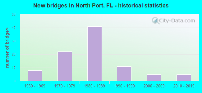
- New bridges - historical statistics
- 81960-1969
- 221970-1979
- 411980-1989
- 111990-1999
- 52000-2009
- 52010-2019

- Reconstructed bridges - Historical Statistics
- 21980-1989
- 81990-1999
- 12000-2009
- 102010-2019


- Bridge Condition - Deck
- 4.5%Very good
- 58.2%Good
- 26.9%Satisfactory
- 6.0%Fair
- 4.5%Poor

- Bridge Condition - Superstructure
- 3.0%Very good
- 62.7%Good
- 23.9%Satisfactory
- 6.0%Fair
- 4.5%Poor

- Bridge Condition - Substructure
- 6.0%Very good
- 86.6%Good
- 7.5%Satisfactory

- Bridge Condition - Channel
- 16.7%Excellent
- 9.7%Very good
- 55.6%Good
- 18.1%Satisfactory

- Bridge Condition - Culverts
- 50.0%Good
- 50.0%Satisfactory
Find on map >> Show street view
Structure Number: 10108, Location: 0.4MI. N OF LONGLEY DR. (Lat: 27.026611, Lng: -82.195911), Route carried "on" structure: US 41, Year Built: 1974, Status: Open, Structure Length: 0.64m (2.10ft), Average Daily Traffic: 29,000 (year 2020), Truck Traffic: 5%, Average Future Daily Traffic: 50,315 (year 2042), Design Load: H 20, Features Intersected: BAYSHORE WATERWAY
Minimum Vertical Clearance: 30+ m (98+ ft), Kilometerpoint: 40.592, Lanes on structure: 6, Base Highway Network: Yes, Owner: State Highway Agency, Approaching Roadway Width: 27.4m (89.9ft), Skew: 12 degrees, Material/Design: Concrete, Design/Construction: Culvert, Number Of Spans In Main Unit: 2, Length of Maximum Span: 3.4m (11.2ft)
Condition: Channel: Good, Culverts: Satisfactory, Operating Rating: 81.3 metric tons, Method Used To Determine Operating Rating: Load and Resistance Factor (LRFR), Inventory Rating: 62.7 metric tons, Method Used To Determine Inventory Rating: Load and Resistance Factor (LRFR), Structural Evaluation: Equal to present minimum criteria, Waterway Adequacy: Better than present minimum criteria, Approach Roadway Alignment: Equal to present desirable criteria, Designated Inspection Frequency: Every 24 months, Inspection Date: October 2021
Find on map >> Show street view
Structure Number: 14039, Location: 0.8MI SOUTH OF US-41 (Lat: 27.021306, Lng: -82.205250), Route carried "on" structure: County highway , Year Built: 1968, Year Reconstructed: 2003, Status: Open, Structure Length: 3.35m (10.99ft), Average Daily Traffic: 3,700 (year 2019), Truck Traffic: 5%, Average Future Daily Traffic: 6,420 (year 2041), Design Load: H 20, Features Intersected: BAYSHORE WATERWAY, Facility Carried by Structure: CORNELIUS BLVD.
Minimum Vertical Clearance: 30+ m (98+ ft), Kilometerpoint: 3.133, Lanes on structure: 2, Owner: County Highway Agency, Approaching Roadway Width: 6.8m (22.3ft), Material/Design: Prestressed concrete, Design/Construction: Slab, Number Of Spans In Main Unit: 3, Length of Maximum Span: 12.1m (39.7ft), Curb-To-Curb Width: 8.0m (26.2ft), Out-to-Out Width: 9.3m (30.5ft)
Condition: Deck: Good, Superstructure: Good, Substructure: Good, Channel: Excellent, Operating Rating: 46.7 metric tons, Method Used To Determine Operating Rating: Load Factor (LF), Inventory Rating: 28.1 metric tons, Method Used To Determine Inventory Rating: Load Factor (LF), Structural Evaluation: Better than present minimum criteria, Deck Geometry: High priority of corrective action, Waterway Adequacy: Better than present minimum criteria, Approach Roadway Alignment: Better than present minimum criteria, Designated Inspection Frequency: Every 24 months, Underwater Inspection Frequency: Every 24 months, Inspection Date: May 2020, Underwater Inspection Date: April 2020, Deck Structure Type: Concrete Precast Panels, Wearing Surface/Protective System: Wearing Surface: Integral Concrete
Find on map >> Show street view
Structure Number: 14044, Location: 0.4MI W OF CORNELIUS BLVD (Lat: 27.018289, Lng: -82.210750), Route carried "on" structure: County highway , Year Built: 1970, Status: Open, Structure Length: 4.11m (13.48ft), Average Daily Traffic: 1,200 (year 2019), Truck Traffic: 5%, Average Future Daily Traffic: 2,082 (year 2041), Design Load: HS 20, Features Intersected: JUPITER WATERWAY, Facility Carried by Structure: CHAMBERLAIN BLVD.
Minimum Vertical Clearance: 30+ m (98+ ft), Kilometerpoint: 4.664, Lanes on structure: 2, Owner: County Highway Agency, Approaching Roadway Width: 7.7m (25.3ft), Skew: 2 degrees, Material/Design: Prestressed concrete, Design/Construction: Slab, Number Of Spans In Main Unit: 5, Length of Maximum Span: 8.2m (26.9ft), Curb or Sidewalk Widths: Left: 0.5m (1.6ft), Right: 0.5m (1.6ft), Curb-To-Curb Width: 8.0m (26.2ft), Out-to-Out Width: 9.3m (30.5ft)
Condition: Deck: Good, Superstructure: Good, Substructure: Good, Channel: Excellent, Operating Rating: 51.1 metric tons, Method Used To Determine Operating Rating: Load Factor (LF), Inventory Rating: 30.7 metric tons, Method Used To Determine Inventory Rating: Load Factor (LF), Structural Evaluation: Better than present minimum criteria, Deck Geometry: Meets minimum limits, Waterway Adequacy: Better than present minimum criteria, Approach Roadway Alignment: Better than present minimum criteria, Designated Inspection Frequency: Every 24 months, Underwater Inspection Frequency: Every 24 months, Inspection Date: May 2020, Underwater Inspection Date: April 2020, Deck Structure Type: Concrete Precast Panels, Wearing Surface/Protective System: Wearing Surface: Bituminous
Find on map >> Show street view
Structure Number: 14045, Location: 1.3MI W OF CORNELIUS BLVD (Lat: 27.018347, Lng: -82.226014), Route carried "on" structure: County highway , Year Built: 1970, Status: Open, Structure Length: 4.42m (14.50ft), Average Daily Traffic: 1,200 (year 2019), Truck Traffic: 4%, Average Future Daily Traffic: 2,082 (year 2041), Design Load: HS 20, Features Intersected: APOLLO WATERWAY, Facility Carried by Structure: CHAMBERLAIN BLVD.
Minimum Vertical Clearance: 30+ m (98+ ft), Kilometerpoint: 3.146, Lanes on structure: 2, Owner: County Highway Agency, Approaching Roadway Width: 7.2m (23.6ft), Skew: 2 degrees, Material/Design: Prestressed concrete, Design/Construction: Slab, Number Of Spans In Main Unit: 5, Length of Maximum Span: 8.8m (28.9ft), Curb or Sidewalk Widths: Left: 0.6m (2.0ft), Right: 0.6m (2.0ft), Curb-To-Curb Width: 8.0m (26.2ft), Out-to-Out Width: 9.2m (30.2ft)
Condition: Deck: Good, Superstructure: Good, Substructure: Good, Channel: Good, Operating Rating: 71.8 metric tons, Method Used To Determine Operating Rating: Load Factor (LF), Inventory Rating: 37.6 metric tons, Method Used To Determine Inventory Rating: Load Factor (LF), Structural Evaluation: Better than present minimum criteria, Deck Geometry: Meets minimum limits, Waterway Adequacy: Equal to present desirable criteria, Approach Roadway Alignment: Better than present minimum criteria, Designated Inspection Frequency: Every 24 months, Underwater Inspection Frequency: Every 24 months, Inspection Date: May 2020, Underwater Inspection Date: April 2020, Deck Structure Type: Concrete Precast Panels, Wearing Surface/Protective System: Wearing Surface: Bituminous
Find on map >> Show street view
Structure Number: 14047, Location: 3MI W OF CORNELIUS BLVD. (Lat: 27.025494, Lng: -82.249983), Route carried "on" structure: County highway , Year Built: 1970, Status: Open, Structure Length: 2.77m (9.09ft), Average Daily Traffic: 1,200 (year 2019), Truck Traffic: 5%, Average Future Daily Traffic: 2,082 (year 2041), Design Load: HS 20, Features Intersected: MARKHAM WATERWAY, Facility Carried by Structure: CHAMBERLAIN BLVD.
Minimum Vertical Clearance: 30+ m (98+ ft), Kilometerpoint: 0.455, Lanes on structure: 2, Owner: County Highway Agency, Approaching Roadway Width: 7.2m (23.6ft), Material/Design: Prestressed concrete, Design/Construction: Slab, Number Of Spans In Main Unit: 3, Length of Maximum Span: 9.2m (30.2ft), Curb or Sidewalk Widths: Left: 0.5m (1.6ft), Right: 0.5m (1.6ft), Curb-To-Curb Width: 8.0m (26.2ft), Out-to-Out Width: 9.2m (30.2ft)
Condition: Deck: Good, Superstructure: Good, Substructure: Good, Channel: Excellent, Operating Rating: 67.0 metric tons, Method Used To Determine Operating Rating: Load Factor (LF), Inventory Rating: 34.7 metric tons, Method Used To Determine Inventory Rating: Load Factor (LF), Structural Evaluation: Better than present minimum criteria, Deck Geometry: Meets minimum limits, Waterway Adequacy: Equal to present desirable criteria, Approach Roadway Alignment: Meets minimum limits, Designated Inspection Frequency: Every 24 months, Underwater Inspection Frequency: Every 24 months, Inspection Date: May 2020, Underwater Inspection Date: April 2020, Deck Structure Type: Concrete Precast Panels, Wearing Surface/Protective System: Wearing Surface: Bituminous
Find on map >> Show street view
Structure Number: 14048, Location: 0.2MI N OF ELEANOR (Lat: 27.006833, Lng: -82.222194), Route carried "on" structure: County highway , Year Built: 1970, Year Reconstructed: 2009, Status: Open, Structure Length: 4.27m (14.01ft), Average Daily Traffic: 2,800 (year 2019), Truck Traffic: 5%, Average Future Daily Traffic: 4,858 (year 2041), Design Load: HL 93, Features Intersected: JUPITER WATERWAY, Facility Carried by Structure: JACOBS STREET
Minimum Vertical Clearance: 30+ m (98+ ft), Kilometerpoint: 3.111, Lanes on structure: 2, Owner: County Highway Agency, Approaching Roadway Width: 7.1m (23.3ft), Material/Design: Prestressed concrete, Design/Construction: Slab, Number Of Spans In Main Unit: 5, Length of Maximum Span: 8.5m (27.9ft), Curb or Sidewalk Widths: Left: 0.0m, Right: 1.5m (4.9ft), Curb-To-Curb Width: 8.5m (27.9ft), Out-to-Out Width: 10.8m (35.4ft)
Condition: Deck: Very good, Superstructure: Very good, Substructure: Good, Channel: Good, Operating Rating: 57.5 metric tons, Method Used To Determine Operating Rating: Load and Resistance Factor (LRFR), Inventory Rating: 36.6 metric tons, Method Used To Determine Inventory Rating: Load and Resistance Factor (LRFR), Structural Evaluation: Better than present minimum criteria, Deck Geometry: Meets minimum limits, Waterway Adequacy: Better than present minimum criteria, Approach Roadway Alignment: Better than present minimum criteria, Designated Inspection Frequency: Every 24 months, Underwater Inspection Frequency: Every 24 months, Inspection Date: May 2020, Underwater Inspection Date: April 2020, Deck Structure Type: Concrete Precast Panels, Wearing Surface/Protective System: Wearing Surface: Integral Concrete
Find on map >> Show street view
Structure Number: 14049, Location: 0.4MI W OF CORNELIUS BLVD (Lat: 27.015028, Lng: -82.212944), Route carried "on" structure: City street , Year Built: 1972, Status: Open, Structure Length: 3.96m (12.99ft), Average Daily Traffic: 1,450 (year 2019), Truck Traffic: 5%, Average Future Daily Traffic: 2,516 (year 2041), Design Load: HS 20, Features Intersected: JUPITER WATERWAY, Facility Carried by Structure: BISCAYNE DRIVE
Minimum Vertical Clearance: 30+ m (98+ ft), Kilometerpoint: 3.174, Lanes on structure: 2, Owner: County Highway Agency, Approaching Roadway Width: 7.9m (25.9ft), Material/Design: Prestressed concrete, Design/Construction: Slab, Number Of Spans In Main Unit: 5, Length of Maximum Span: 7.9m (25.9ft), Curb or Sidewalk Widths: Left: 0.9m (3.0ft), Right: 0.9m (3.0ft), Curb-To-Curb Width: 8.5m (27.9ft), Out-to-Out Width: 11.1m (36.4ft)
Condition: Deck: Satisfactory, Superstructure: Satisfactory, Substructure: Satisfactory, Channel: Good, Operating Rating: 69.6 metric tons, Method Used To Determine Operating Rating: Load Factor (LF), Inventory Rating: 37.2 metric tons, Method Used To Determine Inventory Rating: Load Factor (LF), Structural Evaluation: Equal to present minimum criteria, Deck Geometry: Somewhat better than minimum adequacy, Waterway Adequacy: Equal to present desirable criteria, Approach Roadway Alignment: Better than present minimum criteria, Designated Inspection Frequency: Every 24 months, Underwater Inspection Frequency: Every 24 months, Inspection Date: May 2020, Underwater Inspection Date: April 2020, Deck Structure Type: Concrete Precast Panels, Wearing Surface/Protective System: Wearing Surface: Bituminous
Find on map >> Show street view
Structure Number: 170055, Location: 100FT S OF US-41 (Lat: 27.041222, Lng: -82.299869), Route carried "on" structure: County highway 777, Year Built: 1965, Year Reconstructed: 1996, Status: Open, Structure Length: 0.81m (2.66ft), Average Daily Traffic: 13,500 (year 2021), Truck Traffic: 7%, Average Future Daily Traffic: 23,423 (year 2042), Design Load: HS 20, Features Intersected: BRANCH OF MYAKKA RIVER, Facility Carried by Structure: SOUTH RIVER ROAD
Minimum Vertical Clearance: 30.45m (99.90ft), Kilometerpoint: 12.287, Lanes on structure: 7, Owner: County Highway Agency, Approaching Roadway Width: 31.2m (102.4ft), Skew: 2 degrees, Material/Design: Concrete, Design/Construction: Culvert, Number Of Spans In Main Unit: 3, Length of Maximum Span: 2.7m (8.9ft)
Condition: Channel: Very good, Culverts: Good, Inventory Rating: 62.4 metric tons, Method Used To Determine Inventory Rating: Load Factor (LF), Structural Evaluation: Better than present minimum criteria, Waterway Adequacy: Better than present minimum criteria, Approach Roadway Alignment: Equal to present minimum criteria, Designated Inspection Frequency: Every 24 months, Inspection Date: March 2021
Find on map >> Show street view
Structure Number: 170063, Location: 650FT N OF CHARLOTTE CTY (Lat: 27.033689, Lng: -82.206744), Route carried "on" structure: US 41, Year Built: 1974, Year Reconstructed: 2015, Status: Open, Structure Length: 0.66m (2.17ft), Average Daily Traffic: 31,500 (year 2020), Truck Traffic: 6%, Average Future Daily Traffic: 54,652 (year 2042), Design Load: HS 20+Mod, Features Intersected: JUPITER WATERWAY
Minimum Vertical Clearance: 30.45m (99.90ft), Kilometerpoint: 0.188, Lanes on structure: 6, Base Highway Network: Yes, Owner: State Highway Agency, Approaching Roadway Width: 25.2m (82.7ft), Skew: 10 degrees, Material/Design: Concrete, Design/Construction: Culvert, Number Of Spans In Main Unit: 2, Length of Maximum Span: 3.3m (10.8ft), Curb or Sidewalk Widths: Left: 1.4m (4.6ft), Right: 1.4m (4.6ft)
Condition: Channel: Good, Culverts: Satisfactory, Inventory Rating: 74.3 metric tons, Method Used To Determine Inventory Rating: Load Factor (LF), Structural Evaluation: Equal to present minimum criteria, Waterway Adequacy: Equal to present desirable criteria, Approach Roadway Alignment: Equal to present desirable criteria, Designated Inspection Frequency: Every 24 months, Underwater Inspection Frequency: Every 24 months, Inspection Date: March 2021, Underwater Inspection Date: Febuary 2021
Find on map >> Show street view
Structure Number: 170067, Location: 8.6MI E OF I-75 (Lat: 27.237803, Lng: -82.315081), Route carried "on" structure: State highway 72, Year Built: 2008, Status: Open, Structure Length: 2.74m (8.99ft), Average Daily Traffic: 2,400 (year 2020), Truck Traffic: 4%, Average Future Daily Traffic: 4,164 (year 2042), Design Load: HL 93, Features Intersected: MYAKKA RIVER OVERFLOW
Minimum Vertical Clearance: 30+ m (98+ ft), Kilometerpoint: 21.956, Lanes on structure: 2, Base Highway Network: Yes, Owner: State Highway Agency, Approaching Roadway Width: 9.8m (32.2ft), Material/Design: Concrete continuous, Design/Construction: Slab, Number Of Spans In Main Unit: 3, Length of Maximum Span: 9.1m (29.9ft), Curb-To-Curb Width: 14.0m (45.9ft), Out-to-Out Width: 14.9m (48.9ft)
Condition: Deck: Good, Superstructure: Good, Substructure: Very good, Channel: Good, Operating Rating: 50.3 metric tons, Method Used To Determine Operating Rating: Load and Resistance Factor (LRFR), Inventory Rating: 38.8 metric tons, Method Used To Determine Inventory Rating: Load and Resistance Factor (LRFR), Structural Evaluation: Better than present minimum criteria, Deck Geometry: Superior to present desirable criteria, Waterway Adequacy: Equal to present desirable criteria, Approach Roadway Alignment: Equal to present desirable criteria, Designated Inspection Frequency: Every 24 months, Inspection Date: June 2021, Deck Structure Type: Concrete Cast-file-Place
Find on map >> Show street view
Structure Number: 170071, Location: 15.6 MI East of I-75 (Lat: 27.195608, Lng: -82.216781), Route carried "on" structure: State highway 72, Year Built: 2008, Status: Open, Structure Length: 2.74m (8.99ft), Average Daily Traffic: 2,400 (year 2020), Truck Traffic: 4%, Average Future Daily Traffic: 4,164 (year 2042), Design Load: HL 93, Features Intersected: DEER PRAIRIE SLOUGH
Minimum Vertical Clearance: 30+ m (98+ ft), Kilometerpoint: 32.975, Lanes on structure: 2, Base Highway Network: Yes, Owner: State Highway Agency, Approaching Roadway Width: 10.4m (34.1ft), Material/Design: Concrete continuous, Design/Construction: Slab, Number Of Spans In Main Unit: 3, Length of Maximum Span: 9.1m (29.9ft), Curb-To-Curb Width: 14.0m (45.9ft), Out-to-Out Width: 14.9m (48.9ft)
Condition: Deck: Good, Superstructure: Good, Substructure: Good, Channel: Good, Operating Rating: 50.3 metric tons, Method Used To Determine Operating Rating: Load and Resistance Factor (LRFR), Inventory Rating: 38.8 metric tons, Method Used To Determine Inventory Rating: Load and Resistance Factor (LRFR), Structural Evaluation: Better than present minimum criteria, Deck Geometry: Superior to present desirable criteria, Waterway Adequacy: Equal to present desirable criteria, Approach Roadway Alignment: Equal to present desirable criteria, Designated Inspection Frequency: Every 24 months, Underwater Inspection Frequency: Every 23 months, Inspection Date: June 2021, Underwater Inspection Date: June 2021, Deck Structure Type: Concrete Cast-file-Place
Find on map >> Show street view
Structure Number: 170073, Location: 1.4MI N OF SUMTER BLVD (Lat: 27.044958, Lng: -82.241936), Route carried "on" structure: US 41, Year Built: 1975, Status: Open, Structure Length: 7.32m (24.02ft), Average Daily Traffic: 15,750 (year 2020), Truck Traffic: 6%, Average Future Daily Traffic: 27,326 (year 2042), Design Load: HS 20+Mod, Features Intersected: BIG SLOUGH
Minimum Vertical Clearance: 30.45m (99.90ft), Kilometerpoint: 3.867, Lanes on structure: 2, Base Highway Network: Yes, Owner: State Highway Agency, Approaching Roadway Width: 12.1m (39.7ft), Material/Design: Prestressed concrete, Design/Construction: Stringer/Multi-beam, Number Of Spans In Main Unit: 6, Length of Maximum Span: 12.2m (40.0ft), Curb-To-Curb Width: 12.1m (39.7ft), Out-to-Out Width: 13.0m (42.7ft)
Condition: Deck: Good, Superstructure: Good, Substructure: Good, Channel: Good, Operating Rating: 57.2 metric tons, Method Used To Determine Operating Rating: Allowable Stress (AS), Inventory Rating: 47.2 metric tons, Method Used To Determine Inventory Rating: Allowable Stress (AS), Structural Evaluation: Better than present minimum criteria, Deck Geometry: Better than present minimum criteria, Waterway Adequacy: Equal to present desirable criteria, Approach Roadway Alignment: Equal to present desirable criteria, Designated Inspection Frequency: Every 24 months, Underwater Inspection Frequency: Every 24 months, Inspection Date: March 2021, Underwater Inspection Date: Febuary 2021, Deck Structure Type: Concrete Cast-file-Place
Find on map >> Show street view
Structure Number: 170074, Location: 1.4MI N OF SUMTER BLVD (Lat: 27.045147, Lng: -82.241933), Route carried "on" structure: US 41, Year Built: 1975, Status: Open, Structure Length: 7.32m (24.02ft), Average Daily Traffic: 15,750 (year 2020), Truck Traffic: 6%, Average Future Daily Traffic: 27,326 (year 2042), Design Load: HS 20+Mod, Features Intersected: BIG SLOUGH
Minimum Vertical Clearance: 30.45m (99.90ft), Kilometerpoint: 3.867, Lanes on structure: 2, Base Highway Network: Yes, Owner: State Highway Agency, Approaching Roadway Width: 12.1m (39.7ft), Material/Design: Prestressed concrete, Design/Construction: Stringer/Multi-beam, Number Of Spans In Main Unit: 6, Length of Maximum Span: 12.2m (40.0ft), Curb-To-Curb Width: 12.1m (39.7ft), Out-to-Out Width: 13.0m (42.7ft)
Condition: Deck: Good, Superstructure: Good, Substructure: Good, Channel: Good, Operating Rating: 57.2 metric tons, Method Used To Determine Operating Rating: Allowable Stress (AS), Inventory Rating: 47.2 metric tons, Method Used To Determine Inventory Rating: Allowable Stress (AS), Structural Evaluation: Better than present minimum criteria, Deck Geometry: Better than present minimum criteria, Waterway Adequacy: Equal to present desirable criteria, Approach Roadway Alignment: Equal to present desirable criteria, Designated Inspection Frequency: Every 24 months, Underwater Inspection Frequency: Every 24 months, Inspection Date: March 2021, Underwater Inspection Date: Febuary 2021, Deck Structure Type: Concrete Cast-file-Place
Find on map >> Show street view
Structure Number: 170114, Location: 0.6MI S OF RIVER RD. (Lat: 27.046189, Lng: -82.291378), Route carried "on" structure: US 41, Year Built: 1977, Status: Open, Structure Length: 5.19m (17.03ft), Average Daily Traffic: 15,750 (year 2020), Truck Traffic: 6%, Average Future Daily Traffic: 27,326 (year 2042), Design Load: HS 20, Features Intersected: MYAKKA RIVER EAST BRANCH
Minimum Vertical Clearance: 30.45m (99.90ft), Kilometerpoint: 8.876, Lanes on structure: 2, Base Highway Network: Yes, Owner: State Highway Agency, Approaching Roadway Width: 10.1m (33.1ft), Material/Design: Prestressed concrete, Design/Construction: Stringer/Multi-beam, Number Of Spans In Main Unit: 4, Length of Maximum Span: 13.0m (42.7ft), Curb-To-Curb Width: 12.0m (39.4ft), Out-to-Out Width: 12.8m (42.0ft)
Condition: Deck: Good, Superstructure: Good, Substructure: Good, Channel: Good, Operating Rating: 51.7 metric tons, Method Used To Determine Operating Rating: Allowable Stress (AS), Inventory Rating: 45.4 metric tons, Method Used To Determine Inventory Rating: Allowable Stress (AS), Structural Evaluation: Better than present minimum criteria, Deck Geometry: Better than present minimum criteria, Waterway Adequacy: Equal to present desirable criteria, Approach Roadway Alignment: Equal to present desirable criteria, Designated Inspection Frequency: Every 24 months, Underwater Inspection Frequency: Every 24 months, Inspection Date: March 2021, Underwater Inspection Date: Febuary 2021, Deck Structure Type: Concrete Cast-file-Place
Find on map >> Show street view
Structure Number: 170115, Location: 0.6MI S OF RIVER RD. (Lat: 27.045983, Lng: -82.291314), Route carried "on" structure: US 41, Year Built: 1977, Status: Open, Structure Length: 5.19m (17.03ft), Average Daily Traffic: 15,750 (year 2020), Truck Traffic: 6%, Average Future Daily Traffic: 27,326 (year 2042), Design Load: HS 20, Features Intersected: MYAKKA RIVER EAST BRANCH
Minimum Vertical Clearance: 30.45m (99.90ft), Kilometerpoint: 8.876, Lanes on structure: 2, Base Highway Network: Yes, Owner: State Highway Agency, Approaching Roadway Width: 10.1m (33.1ft), Material/Design: Prestressed concrete, Design/Construction: Stringer/Multi-beam, Number Of Spans In Main Unit: 4, Length of Maximum Span: 13.0m (42.7ft), Curb-To-Curb Width: 12.0m (39.4ft), Out-to-Out Width: 12.8m (42.0ft)
Condition: Deck: Good, Superstructure: Good, Substructure: Good, Channel: Very good, Operating Rating: 51.7 metric tons, Method Used To Determine Operating Rating: Allowable Stress (AS), Inventory Rating: 45.4 metric tons, Method Used To Determine Inventory Rating: Allowable Stress (AS), Structural Evaluation: Better than present minimum criteria, Deck Geometry: Better than present minimum criteria, Waterway Adequacy: Equal to present desirable criteria, Approach Roadway Alignment: Equal to present desirable criteria, Designated Inspection Frequency: Every 24 months, Underwater Inspection Frequency: Every 24 months, Inspection Date: March 2021, Underwater Inspection Date: Febuary 2021, Deck Structure Type: Concrete Cast-file-Place
Find on map >> Show street view
Structure Number: 170116, Location: 0.5MI S OF RIVER ROAD (Lat: 27.045231, Lng: -82.293031), Route carried "on" structure: US 41, Year Built: 1977, Year Reconstructed: 1986, Status: Open, Structure Length: 11.35m (37.24ft), Average Daily Traffic: 15,750 (year 2020), Truck Traffic: 6%, Average Future Daily Traffic: 27,326 (year 2042), Design Load: HS 20+Mod, Features Intersected: MYAKKA RIVER
Minimum Vertical Clearance: 30.45m (99.90ft), Kilometerpoint: 9.041, Lanes on structure: 2, Base Highway Network: Yes, Owner: State Highway Agency, Approaching Roadway Width: 10.1m (33.1ft), Material/Design: Prestressed concrete, Design/Construction: Stringer/Multi-beam, Number Of Spans In Main Unit: 8, Length of Maximum Span: 14.2m (46.6ft), Curb-To-Curb Width: 12.0m (39.4ft), Out-to-Out Width: 12.8m (42.0ft)
Condition: Deck: Satisfactory, Superstructure: Good, Substructure: Good, Channel: Excellent, Operating Rating: 69.2 metric tons, Method Used To Determine Operating Rating: Load Factor (LF), Inventory Rating: 33.9 metric tons, Method Used To Determine Inventory Rating: Load Factor (LF), Structural Evaluation: Better than present minimum criteria, Deck Geometry: Better than present minimum criteria, Waterway Adequacy: Equal to present desirable criteria, Approach Roadway Alignment: Equal to present desirable criteria, Designated Inspection Frequency: Every 24 months, Underwater Inspection Frequency: Every 24 months, Inspection Date: March 2021, Underwater Inspection Date: Febuary 2021, Deck Structure Type: Concrete Cast-file-Place
Find on map >> Show street view
Structure Number: 170117, Location: 0.5MI S OF RIVER RD (Lat: 27.045036, Lng: -82.292931), Route carried "on" structure: US 41, Year Built: 1977, Year Reconstructed: 1986, Status: Open, Structure Length: 11.35m (37.24ft), Average Daily Traffic: 15,750 (year 2020), Truck Traffic: 6%, Average Future Daily Traffic: 27,326 (year 2042), Design Load: HS 20+Mod, Features Intersected: MYAKKA RIVER
Minimum Vertical Clearance: 30.45m (99.90ft), Kilometerpoint: 9.041, Lanes on structure: 2, Base Highway Network: Yes, Owner: State Highway Agency, Approaching Roadway Width: 10.1m (33.1ft), Material/Design: Prestressed concrete, Design/Construction: Stringer/Multi-beam, Number Of Spans In Main Unit: 8, Length of Maximum Span: 14.2m (46.6ft), Curb-To-Curb Width: 12.0m (39.4ft), Out-to-Out Width: 12.8m (42.0ft)
Condition: Deck: Good, Superstructure: Good, Substructure: Good, Channel: Excellent, Operating Rating: 69.2 metric tons, Method Used To Determine Operating Rating: Load Factor (LF), Inventory Rating: 34.0 metric tons, Method Used To Determine Inventory Rating: Load Factor (LF), Structural Evaluation: Better than present minimum criteria, Deck Geometry: Better than present minimum criteria, Waterway Adequacy: Equal to present desirable criteria, Approach Roadway Alignment: Equal to present desirable criteria, Designated Inspection Frequency: Every 24 months, Underwater Inspection Frequency: Every 24 months, Inspection Date: March 2021, Underwater Inspection Date: Febuary 2021, Deck Structure Type: Concrete Cast-file-Place
Find on map >> Show street view
Structure Number: 170121, Location: 1.1 MI NORTH OF US-41 (Lat: 27.033475, Lng: -82.163533), Route carried "on" structure: City street , Year Built: 1982, Status: Open, Structure Length: 5.27m (17.29ft), Average Daily Traffic: 16,800 (year 2020), Truck Traffic: 6%, Average Future Daily Traffic: 29,148 (year 2042), Design Load: HS 20, Features Intersected: COCOPLUM WATERWAY, Facility Carried by Structure: TOLEDO BLADE BLVD
Minimum Vertical Clearance: 30+ m (98+ ft), Kilometerpoint: 0.056, Lanes on structure: 2, Base Highway Network: Yes, Owner: City or Municipal Highway Agency, Approaching Roadway Width: 9.0m (29.5ft), Material/Design: Prestressed concrete, Design/Construction: Slab, Number Of Spans In Main Unit: 5, Length of Maximum Span: 11.1m (36.4ft), Curb-To-Curb Width: 12.3m (40.4ft), Out-to-Out Width: 13.3m (43.6ft)
Condition: Deck: Satisfactory, Superstructure: Satisfactory, Substructure: Satisfactory, Channel: Good, Operating Rating: 85.3 metric tons, Method Used To Determine Operating Rating: Allowable Stress (AS), Inventory Rating: 66.2 metric tons, Method Used To Determine Inventory Rating: Allowable Stress (AS), Structural Evaluation: Equal to present minimum criteria, Deck Geometry: Better than present minimum criteria, Waterway Adequacy: Equal to present desirable criteria, Approach Roadway Alignment: Equal to present desirable criteria, Designated Inspection Frequency: Every 24 months, Underwater Inspection Frequency: Every 24 months, Inspection Date: September 2020, Underwater Inspection Date: August 2020, Deck Structure Type: Concrete Precast Panels, Wearing Surface/Protective System: Wearing Surface: Bituminous
Find on map >> Show street view
Structure Number: 170122, Location: 4.2 MI NORTH OF US-41 (Lat: 27.075944, Lng: -82.155525), Route carried "on" structure: City street , Year Built: 1982, Status: Open, Structure Length: 3.49m (11.45ft), Average Daily Traffic: 10,500 (year 2019), Truck Traffic: 7%, Average Future Daily Traffic: 18,218 (year 2041), Design Load: HS 20, Features Intersected: SNOVER CANAL, Facility Carried by Structure: TOLEDO BLADE NB
Minimum Vertical Clearance: 30+ m (98+ ft), Kilometerpoint: 4.941, Lanes on structure: 2, Base Highway Network: Yes, Owner: City or Municipal Highway Agency, Approaching Roadway Width: 9.4m (30.8ft), Material/Design: Prestressed concrete, Design/Construction: Slab, Number Of Spans In Main Unit: 3, Length of Maximum Span: 11.7m (38.4ft), Curb-To-Curb Width: 12.4m (40.7ft), Out-to-Out Width: 13.3m (43.6ft)
Condition: Deck: Satisfactory, Superstructure: Satisfactory, Substructure: Good, Channel: Very good, Operating Rating: 85.3 metric tons, Method Used To Determine Operating Rating: Allowable Stress (AS), Inventory Rating: 67.1 metric tons, Method Used To Determine Inventory Rating: Allowable Stress (AS), Structural Evaluation: Equal to present minimum criteria, Deck Geometry: Better than present minimum criteria, Waterway Adequacy: Equal to present desirable criteria, Approach Roadway Alignment: Equal to present desirable criteria, Designated Inspection Frequency: Every 24 months, Inspection Date: September 2020, Deck Structure Type: Concrete Precast Panels, Wearing Surface/Protective System: Wearing Surface: Bituminous
Find on map >> Show street view
Structure Number: 170123, Location: 12.8 MI N OF CHARLOTTE CO (Lat: 27.099653, Lng: -82.232233), Route carried "on" structure: County highway , Year Built: 1981, Status: Open, Structure Length: 8.74m (28.67ft), Average Daily Traffic: 2,900 (year 2018), Truck Traffic: 8%, Average Future Daily Traffic: 5,032 (year 2040), Design Load: HS 20, Features Intersected: I-75 (SR-93), Facility Carried by Structure: PONCE DE LEON BLVD
Minimum Vertical Clearance: 30+ m (98+ ft), Kilometerpoint: 2.578, Lanes on structure: 2, Lanes under structure: 6, Owner: State Highway Agency, Approaching Roadway Width: 12.1m (39.7ft), Material/Design: Prestressed concrete, Design/Construction: Stringer/Multi-beam, Number Of Spans In Main Unit: 4, Length of Maximum Span: 34.4m (112.9ft), Curb-To-Curb Width: 12.1m (39.7ft), Out-to-Out Width: 13.0m (42.7ft)
Condition: Deck: Very good, Superstructure: Good, Substructure: Good, Operating Rating: 39.2 metric tons, Method Used To Determine Operating Rating: Load and Resistance Factor (LRFR), Inventory Rating: 34.9 metric tons, Method Used To Determine Inventory Rating: Load and Resistance Factor (LRFR), Structural Evaluation: Better than present minimum criteria, Deck Geometry: Somewhat better than minimum adequacy, Underclear: Somewhat better than minimum adequacy, Approach Roadway Alignment: Equal to present desirable criteria, Designated Inspection Frequency: Every 24 months, Inspection Date: January 2021, Deck Structure Type: Concrete Cast-file-Place
Find on map >> Show street view
Structure Number: 170124, Location: 4.5MI N OF SUMTER BLVD (Lat: 27.099853, Lng: -82.271481), Route carried "on" structure: Interstate 75, Year Built: 1981, Year Reconstructed: 2016, Status: Open, Structure Length: 4.11m (13.48ft), Average Daily Traffic: 37,953 (year 2020), Truck Traffic: 13%, Average Future Daily Traffic: 65,848 (year 2042), Design Load: HL 93, Features Intersected: DEER PRAIRIE CREEK
Minimum Vertical Clearance: 30+ m (98+ ft), Kilometerpoint: 24.427, Lanes on structure: 3, Base Highway Network: Yes, Owner: State Highway Agency, Approaching Roadway Width: 20.6m (67.6ft), Skew: 1 degrees, Material/Design: Concrete continuous, Design/Construction: Slab, Number Of Spans In Main Unit: 5, Length of Maximum Span: 8.2m (26.9ft), Curb-To-Curb Width: 20.6m (67.6ft), Out-to-Out Width: 21.7m (71.2ft)
Condition: Deck: Good, Superstructure: Good, Substructure: Good, Channel: Excellent, Operating Rating: 46.7 metric tons, Method Used To Determine Operating Rating: Load and Resistance Factor (LRFR), Inventory Rating: 36.3 metric tons, Method Used To Determine Inventory Rating: Load and Resistance Factor (LRFR), Structural Evaluation: Better than present minimum criteria, Deck Geometry: Superior to present desirable criteria, Waterway Adequacy: Superior to present desirable criteria, Approach Roadway Alignment: Equal to present desirable criteria, Designated Inspection Frequency: Every 24 months, Inspection Date: March 2021, Deck Structure Type: Concrete Cast-file-Place
Find on map >> Show street view
Structure Number: 170125, Location: 4.5MI N OF SUMTER BLVD (Lat: 27.100236, Lng: -82.271372), Route carried "on" structure: Interstate 75, Year Built: 1981, Year Reconstructed: 2015, Status: Open, Structure Length: 4.11m (13.48ft), Average Daily Traffic: 37,953 (year 2020), Truck Traffic: 13%, Average Future Daily Traffic: 65,848 (year 2042), Design Load: HL 93, Features Intersected: DEER PRAIRIE CREEK
Minimum Vertical Clearance: 30+ m (98+ ft), Kilometerpoint: 24.415, Lanes on structure: 3, Base Highway Network: Yes, Owner: State Highway Agency, Approaching Roadway Width: 20.7m (67.9ft), Skew: 1 degrees, Material/Design: Concrete continuous, Design/Construction: Slab, Number Of Spans In Main Unit: 5, Length of Maximum Span: 8.2m (26.9ft), Curb-To-Curb Width: 20.7m (67.9ft), Out-to-Out Width: 21.6m (70.9ft)
Condition: Deck: Good, Superstructure: Good, Substructure: Good, Channel: Satisfactory, Operating Rating: 46.7 metric tons, Method Used To Determine Operating Rating: Load and Resistance Factor (LRFR), Inventory Rating: 36.3 metric tons, Method Used To Determine Inventory Rating: Load and Resistance Factor (LRFR), Structural Evaluation: Better than present minimum criteria, Deck Geometry: Superior to present desirable criteria, Waterway Adequacy: Superior to present desirable criteria, Approach Roadway Alignment: Equal to present desirable criteria, Designated Inspection Frequency: Every 24 months, Underwater Inspection Frequency: Every 23 months, Inspection Date: March 2021, Underwater Inspection Date: March 2021, Deck Structure Type: Concrete Cast-file-Place
Find on map >> Show street view
Structure Number: 170129, Location: 10.9 MI N OF CHARLOTTE CL (Lat: 27.099108, Lng: -82.203289), Route carried "on" structure: Interstate 75, Year Built: 1981, Year Reconstructed: 2004, Status: Open, Structure Length: 5.39m (17.68ft), Average Daily Traffic: 32,000 (year 2020), Truck Traffic: 14%, Average Future Daily Traffic: 55,520 (year 2042), Design Load: HS 20+Mod, Features Intersected: SUMTER BLVD.
Minimum Vertical Clearance: 30+ m (98+ ft), Kilometerpoint: 17.663, Lanes on structure: 3, Lanes under structure: 4, Base Highway Network: Yes, Owner: State Highway Agency, Approaching Roadway Width: 17.5m (57.4ft), Material/Design: Prestressed concrete, Design/Construction: Stringer/Multi-beam, Number Of Spans In Main Unit: 3, Length of Maximum Span: 31.5m (103.3ft), Curb-To-Curb Width: 17.0m (55.8ft), Out-to-Out Width: 18.0m (59.1ft)
Condition: Deck: Good, Superstructure: Good, Substructure: Good, Operating Rating: 48.2 metric tons, Method Used To Determine Operating Rating: Load Factor (LF), Inventory Rating: 28.8 metric tons, Method Used To Determine Inventory Rating: Load Factor (LF), Structural Evaluation: Better than present minimum criteria, Deck Geometry: Equal to present minimum criteria, Underclear: Equal to present minimum criteria, Approach Roadway Alignment: Equal to present desirable criteria, Designated Inspection Frequency: Every 24 months, Inspection Date: January 2021, Deck Structure Type: Concrete Cast-file-Place
Find on map >> Show street view
Structure Number: 17013, Location: 10.9MI N OF CHARLOTTE CL (Lat: 27.099481, Lng: -82.203250), Route carried "on" structure: Interstate 75, Year Built: 1981, Year Reconstructed: 2004, Status: Open, Structure Length: 5.39m (17.68ft), Average Daily Traffic: 32,000 (year 2020), Truck Traffic: 14%, Average Future Daily Traffic: 55,520 (year 2042), Design Load: HS 20+Mod, Features Intersected: SUMTER BLVD.
Minimum Vertical Clearance: 30+ m (98+ ft), Kilometerpoint: 17.663, Lanes on structure: 3, Lanes under structure: 4, Base Highway Network: Yes, Owner: State Highway Agency, Approaching Roadway Width: 16.9m (55.4ft), Material/Design: Prestressed concrete, Design/Construction: Stringer/Multi-beam, Number Of Spans In Main Unit: 3, Length of Maximum Span: 31.5m (103.3ft), Curb-To-Curb Width: 16.9m (55.4ft), Out-to-Out Width: 18.0m (59.1ft)
Condition: Deck: Good, Superstructure: Good, Substructure: Good, Operating Rating: 48.2 metric tons, Method Used To Determine Operating Rating: Load Factor (LF), Inventory Rating: 28.8 metric tons, Method Used To Determine Inventory Rating: Load Factor (LF), Structural Evaluation: Better than present minimum criteria, Deck Geometry: Equal to present minimum criteria, Underclear: Equal to present minimum criteria, Approach Roadway Alignment: Equal to present desirable criteria, Designated Inspection Frequency: Every 24 months, Inspection Date: January 2021, Deck Structure Type: Concrete Cast-file-Place
Find on map >> Show street view
Structure Number: 170131, Location: 0.3MI N OF SUMTER BLVD (Lat: 27.099194, Lng: -82.209694), Route carried "on" structure: Interstate 75, Year Built: 1981, Year Reconstructed: 2003, Status: Open, Structure Length: 16.46m (54.00ft), Average Daily Traffic: 37,953 (year 2020), Truck Traffic: 13%, Average Future Daily Traffic: 65,848 (year 2042), Design Load: HS 20+Mod, Features Intersected: BIG SLOUGH CANAL
Minimum Vertical Clearance: 30+ m (98+ ft), Kilometerpoint: 18.269, Lanes on structure: 3, Base Highway Network: Yes, Owner: State Highway Agency, Approaching Roadway Width: 17.1m (56.1ft), Skew: 3 degrees, Material/Design: Prestressed concrete, Design/Construction: Stringer/Multi-beam, Number Of Spans In Main Unit: 9, Length of Maximum Span: 18.3m (60.0ft), Curb-To-Curb Width: 17.1m (56.1ft), Out-to-Out Width: 18.0m (59.1ft)
Condition: Deck: Good, Superstructure: Good, Substructure: Good, Channel: Satisfactory, Operating Rating: 48.4 metric tons, Method Used To Determine Operating Rating: Load Factor (LF), Inventory Rating: 29.1 metric tons, Method Used To Determine Inventory Rating: Load Factor (LF), Structural Evaluation: Better than present minimum criteria, Deck Geometry: Equal to present minimum criteria, Waterway Adequacy: Equal to present desirable criteria, Approach Roadway Alignment: Equal to present desirable criteria, Length Of Structure Improvement: 16.46m (54.00ft), Designated Inspection Frequency: Every 24 months, Inspection Date: March 2021, Bridge Improvement Cost: $94,000, Roadway Improvement Cost: $9,000, Total Project Cost: $103,000, Deck Structure Type: Concrete Cast-file-Place
Find on map >> Show street view
Structure Number: 170132, Location: 0.3MI N OF SUMTER BLVD (Lat: 27.099544, Lng: -82.209317), Route carried "on" structure: Interstate 75, Year Built: 1981, Year Reconstructed: 2003, Status: Open, Structure Length: 16.46m (54.00ft), Average Daily Traffic: 37,953 (year 2020), Truck Traffic: 13%, Average Future Daily Traffic: 65,848 (year 2042), Design Load: HS 20+Mod, Features Intersected: BIG SLOUGH CANAL
Minimum Vertical Clearance: 30+ m (98+ ft), Kilometerpoint: 18.235, Lanes on structure: 3, Base Highway Network: Yes, Owner: State Highway Agency, Approaching Roadway Width: 17.1m (56.1ft), Skew: 3 degrees, Material/Design: Prestressed concrete, Design/Construction: Stringer/Multi-beam, Number Of Spans In Main Unit: 9, Length of Maximum Span: 18.3m (60.0ft), Curb-To-Curb Width: 17.1m (56.1ft), Out-to-Out Width: 18.0m (59.1ft)
Condition: Deck: Good, Superstructure: Good, Substructure: Very good, Channel: Excellent, Operating Rating: 48.4 metric tons, Method Used To Determine Operating Rating: Load Factor (LF), Inventory Rating: 29.1 metric tons, Method Used To Determine Inventory Rating: Load Factor (LF), Structural Evaluation: Better than present minimum criteria, Deck Geometry: Equal to present minimum criteria, Waterway Adequacy: Equal to present desirable criteria, Approach Roadway Alignment: Equal to present desirable criteria, Designated Inspection Frequency: Every 24 months, Inspection Date: March 2021, Deck Structure Type: Concrete Cast-file-Place
Find on map >> Show street view
Structure Number: 170133, Location: 1.1MI N OF CHARLOTTE CL (Lat: 27.044872, Lng: -82.068492), Route carried "on" structure: Interstate 75, Year Built: 1980, Year Reconstructed: 2016, Status: Open, Structure Length: 8.75m (28.71ft), Average Daily Traffic: 28,000 (year 2020), Truck Traffic: 15%, Average Future Daily Traffic: 48,580 (year 2042), Design Load: HL 93, Features Intersected: RAINTREE BLVD.
Minimum Vertical Clearance: 30.45m (99.90ft), Kilometerpoint: 1.891, Lanes on structure: 3, Lanes under structure: 2, Base Highway Network: Yes, Owner: State Highway Agency, Approaching Roadway Width: 17.0m (55.8ft), Material/Design: Prestressed concrete, Design/Construction: Stringer/Multi-beam, Number Of Spans In Main Unit: 4, Length of Maximum Span: 28.6m (93.8ft), Curb-To-Curb Width: 17.0m (55.8ft), Out-to-Out Width: 18.0m (59.1ft)
Condition: Deck: Good, Superstructure: Good, Substructure: Good, Operating Rating: 46.1 metric tons, Method Used To Determine Operating Rating: Load and Resistance Factor (LRFR), Inventory Rating: 43.1 metric tons, Method Used To Determine Inventory Rating: Load and Resistance Factor (LRFR), Structural Evaluation: Better than present minimum criteria, Deck Geometry: Equal to present minimum criteria, Underclear: Superior to present desirable criteria, Approach Roadway Alignment: Equal to present desirable criteria, Designated Inspection Frequency: Every 24 months, Inspection Date: January 2021, Deck Structure Type: Concrete Cast-file-Place
Find on map >> Show street view
Structure Number: 170134, Location: 1.1MI N OF CHARLOTTE CL (Lat: 27.045086, Lng: -82.068206), Route carried "on" structure: Interstate 75, Year Built: 1980, Year Reconstructed: 2016, Status: Open, Structure Length: 8.75m (28.71ft), Average Daily Traffic: 28,000 (year 2020), Truck Traffic: 15%, Average Future Daily Traffic: 48,580 (year 2042), Design Load: HL 93, Features Intersected: RAINTREE BLVD.
Minimum Vertical Clearance: 30.45m (99.90ft), Kilometerpoint: 1.888, Lanes on structure: 3, Lanes under structure: 2, Base Highway Network: Yes, Owner: State Highway Agency, Approaching Roadway Width: 17.0m (55.8ft), Material/Design: Prestressed concrete, Design/Construction: Stringer/Multi-beam, Number Of Spans In Main Unit: 4, Length of Maximum Span: 28.6m (93.8ft), Curb-To-Curb Width: 17.0m (55.8ft), Out-to-Out Width: 18.0m (59.1ft)
Condition: Deck: Good, Superstructure: Good, Substructure: Good, Operating Rating: 46.1 metric tons, Method Used To Determine Operating Rating: Load and Resistance Factor (LRFR), Inventory Rating: 43.1 metric tons, Method Used To Determine Inventory Rating: Load and Resistance Factor (LRFR), Structural Evaluation: Better than present minimum criteria, Deck Geometry: Equal to present minimum criteria, Underclear: Superior to present desirable criteria, Approach Roadway Alignment: Equal to present desirable criteria, Designated Inspection Frequency: Every 24 months, Inspection Date: January 2021, Deck Structure Type: Concrete Cast-file-Place
Find on map >> Show street view
Structure Number: 170135, Location: 2.5 MI N OF CHARLOTTE CL (Lat: 27.059731, Lng: -82.085072), Route carried "on" structure: Interstate 75, Year Built: 1980, Year Reconstructed: 2016, Status: Open, Structure Length: 5.04m (16.54ft), Average Daily Traffic: 28,000 (year 2020), Truck Traffic: 15%, Average Future Daily Traffic: 48,580 (year 2042), Design Load: HL 93, Features Intersected: YORKSHIRE ST.
Minimum Vertical Clearance: 30+ m (98+ ft), Kilometerpoint: 4.234, Lanes on structure: 3, Lanes under structure: 2, Base Highway Network: Yes, Owner: State Highway Agency, Approaching Roadway Width: 17.1m (56.1ft), Material/Design: Prestressed concrete, Design/Construction: Stringer/Multi-beam, Number Of Spans In Main Unit: 3, Length of Maximum Span: 27.1m (88.9ft), Curb-To-Curb Width: 17.1m (56.1ft), Out-to-Out Width: 18.0m (59.1ft)
Condition: Deck: Good, Superstructure: Good, Substructure: Good, Operating Rating: 40.5 metric tons, Method Used To Determine Operating Rating: Load and Resistance Factor (LRFR), Inventory Rating: 34.3 metric tons, Method Used To Determine Inventory Rating: Load and Resistance Factor (LRFR), Structural Evaluation: Better than present minimum criteria, Deck Geometry: Equal to present minimum criteria, Underclear: Superior to present desirable criteria, Approach Roadway Alignment: Equal to present desirable criteria, Designated Inspection Frequency: Every 24 months, Inspection Date: January 2021, Deck Structure Type: Concrete Cast-file-Place
Find on map >> Show street view
Structure Number: 170136, Location: 2.5 MI N OF CHARLOTTE CL (Lat: 27.059964, Lng: -82.084806), Route carried "on" structure: Interstate 75, Year Built: 1980, Year Reconstructed: 2017, Status: Open, Structure Length: 5.04m (16.54ft), Average Daily Traffic: 28,000 (year 2020), Truck Traffic: 15%, Average Future Daily Traffic: 48,580 (year 2042), Design Load: HL 93, Features Intersected: YORKSHIRE ST.
Minimum Vertical Clearance: 30.45m (99.90ft), Kilometerpoint: 4.234, Lanes on structure: 3, Lanes under structure: 2, Base Highway Network: Yes, Owner: State Highway Agency, Approaching Roadway Width: 17.0m (55.8ft), Material/Design: Prestressed concrete, Design/Construction: Stringer/Multi-beam, Number Of Spans In Main Unit: 3, Length of Maximum Span: 27.1m (88.9ft), Curb-To-Curb Width: 17.0m (55.8ft), Out-to-Out Width: 18.0m (59.1ft)
Condition: Deck: Good, Superstructure: Good, Substructure: Good, Operating Rating: 44.5 metric tons, Method Used To Determine Operating Rating: Load and Resistance Factor (LRFR), Inventory Rating: 34.3 metric tons, Method Used To Determine Inventory Rating: Load and Resistance Factor (LRFR), Structural Evaluation: Better than present minimum criteria, Deck Geometry: Equal to present minimum criteria, Underclear: Superior to present desirable criteria, Approach Roadway Alignment: Equal to present desirable criteria, Designated Inspection Frequency: Every 24 months, Inspection Date: January 2021, Deck Structure Type: Concrete Cast-file-Place
Find on map >> Show street view
Structure Number: 170137, Location: 3.4MI S OF TOLEDO BLADE (Lat: 27.079900, Lng: -82.107606), Route carried "on" structure: Interstate 75, Year Built: 1981, Year Reconstructed: 2016, Status: Open, Structure Length: 4.00m (13.12ft), Average Daily Traffic: 28,000 (year 2020), Truck Traffic: 15%, Average Future Daily Traffic: 48,580 (year 2042), Design Load: HL 93, Features Intersected: NEW CASTLE WATERWAY
Minimum Vertical Clearance: 30+ m (98+ ft), Kilometerpoint: 7.398, Lanes on structure: 3, Base Highway Network: Yes, Owner: State Highway Agency, Approaching Roadway Width: 17.1m (56.1ft), Material/Design: Concrete continuous, Design/Construction: Slab, Number Of Spans In Main Unit: 4, Length of Maximum Span: 10.0m (32.8ft), Curb-To-Curb Width: 17.1m (56.1ft), Out-to-Out Width: 18.0m (59.1ft)
Condition: Deck: Good, Superstructure: Good, Substructure: Satisfactory, Channel: Satisfactory, Operating Rating: 42.5 metric tons, Method Used To Determine Operating Rating: Load and Resistance Factor (LRFR), Inventory Rating: 32.7 metric tons, Method Used To Determine Inventory Rating: Load and Resistance Factor (LRFR), Structural Evaluation: Equal to present minimum criteria, Deck Geometry: Equal to present minimum criteria, Waterway Adequacy: Equal to present desirable criteria, Approach Roadway Alignment: Equal to present desirable criteria, Designated Inspection Frequency: Every 24 months, Inspection Date: March 2021, Deck Structure Type: Concrete Cast-file-Place
Find on map >> Show street view
Structure Number: 170138, Location: 3.4MI S OF TOLEDO BLADE (Lat: 27.080167, Lng: -82.107389), Route carried "on" structure: Interstate 75, Year Built: 1981, Year Reconstructed: 2016, Status: Open, Structure Length: 4.00m (13.12ft), Average Daily Traffic: 28,000 (year 2020), Truck Traffic: 15%, Average Future Daily Traffic: 48,580 (year 2042), Design Load: HL 93, Features Intersected: NEW CASTLE WATERWAY
Minimum Vertical Clearance: 30+ m (98+ ft), Kilometerpoint: 7.403, Lanes on structure: 3, Base Highway Network: Yes, Owner: State Highway Agency, Approaching Roadway Width: 17.1m (56.1ft), Material/Design: Concrete continuous, Design/Construction: Slab, Number Of Spans In Main Unit: 4, Length of Maximum Span: 10.0m (32.8ft), Curb-To-Curb Width: 17.1m (56.1ft), Out-to-Out Width: 18.0m (59.1ft)
Condition: Deck: Good, Superstructure: Good, Substructure: Good, Channel: Satisfactory, Operating Rating: 42.5 metric tons, Method Used To Determine Operating Rating: Load and Resistance Factor (LRFR), Inventory Rating: 32.7 metric tons, Method Used To Determine Inventory Rating: Load and Resistance Factor (LRFR), Structural Evaluation: Better than present minimum criteria, Deck Geometry: Equal to present minimum criteria, Waterway Adequacy: Equal to present desirable criteria, Approach Roadway Alignment: Equal to present desirable criteria, Designated Inspection Frequency: Every 24 months, Inspection Date: March 2021, Deck Structure Type: Concrete Cast-file-Place
Find on map >> Show street view
Structure Number: 170139, Location: 8.0 MI N/O CHARLOTTE CL (Lat: 27.098558, Lng: -82.155425), Route carried "on" structure: Interstate 75, Year Built: 1981, Year Reconstructed: 2016, Status: Open, Structure Length: 5.79m (19.00ft), Average Daily Traffic: 28,000 (year 2020), Truck Traffic: 15%, Average Future Daily Traffic: 48,580 (year 2042), Design Load: HL 93, Features Intersected: TOLEDO BLADE BOULEVARD
Minimum Vertical Clearance: 30+ m (98+ ft), Kilometerpoint: 12.917, Lanes on structure: 3, Lanes under structure: 4, Base Highway Network: Yes, Owner: State Highway Agency, Approaching Roadway Width: 20.8m (68.2ft), Material/Design: Prestressed concrete, Design/Construction: Stringer/Multi-beam, Number Of Spans In Main Unit: 3, Length of Maximum Span: 32.8m (107.6ft), Curb-To-Curb Width: 20.8m (68.2ft), Out-to-Out Width: 21.7m (71.2ft)
Condition: Deck: Good, Superstructure: Good, Substructure: Good, Operating Rating: 62.7 metric tons, Method Used To Determine Operating Rating: Load and Resistance Factor (LRFR), Inventory Rating: 33.9 metric tons, Method Used To Determine Inventory Rating: Load and Resistance Factor (LRFR), Structural Evaluation: Better than present minimum criteria, Deck Geometry: Superior to present desirable criteria, Underclear: Equal to present minimum criteria, Approach Roadway Alignment: Equal to present desirable criteria, Length Of Structure Improvement: 5.79m (19.00ft), Designated Inspection Frequency: Every 24 months, Inspection Date: January 2021, Bridge Improvement Cost: $400,000, Roadway Improvement Cost: $40,000, Total Project Cost: $440,000, Deck Structure Type: Concrete Cast-file-Place
Find on map >> Show street view
Structure Number: 17014, Location: 8.0 MI N OF CHARLOTTE CL (Lat: 27.098928, Lng: -82.155419), Route carried "on" structure: Interstate 75, Year Built: 1981, Year Reconstructed: 2004, Status: Open, Structure Length: 5.79m (19.00ft), Average Daily Traffic: 28,000 (year 2020), Truck Traffic: 15%, Average Future Daily Traffic: 48,580 (year 2042), Design Load: HS 20, Features Intersected: TOLEDO BLADE BOULEVARD
Minimum Vertical Clearance: 30+ m (98+ ft), Kilometerpoint: 12.917, Lanes on structure: 3, Lanes under structure: 4, Base Highway Network: Yes, Owner: State Highway Agency, Approaching Roadway Width: 16.5m (54.1ft), Material/Design: Prestressed concrete, Design/Construction: Stringer/Multi-beam, Number Of Spans In Main Unit: 3, Length of Maximum Span: 32.8m (107.6ft), Curb-To-Curb Width: 17.1m (56.1ft), Out-to-Out Width: 18.0m (59.1ft)
Condition: Deck: Good, Superstructure: Good, Substructure: Good, Operating Rating: 33.1 metric tons, Method Used To Determine Operating Rating: Load and Resistance Factor (LRFR), Inventory Rating: 29.0 metric tons, Method Used To Determine Inventory Rating: Load and Resistance Factor (LRFR), Structural Evaluation: Better than present minimum criteria, Deck Geometry: Equal to present minimum criteria, Underclear: Better than present minimum criteria, Approach Roadway Alignment: Equal to present desirable criteria, Length Of Structure Improvement: 5.79m (19.00ft), Designated Inspection Frequency: Every 24 months, Inspection Date: January 2021, Bridge Improvement Cost: $400,000, Roadway Improvement Cost: $40,000, Total Project Cost: $440,000, Deck Structure Type: Concrete Cast-file-Place
Find on map >> Show street view
Structure Number: 170144, Location: 300FT. E OF RIVER RD (Lat: 27.042097, Lng: -82.298939), Route carried "on" structure: US 41, Year Built: 1977, Status: Open, Structure Length: 1.20m (3.94ft), Average Daily Traffic: 31,500 (year 2020), Truck Traffic: 6%, Average Future Daily Traffic: 54,652 (year 2042), Design Load: HS 20+Mod, Features Intersected: MYAKKA RIVER DRAIN CANAL
Minimum Vertical Clearance: 30.45m (99.90ft), Kilometerpoint: 9.775, Lanes on structure: 8, Base Highway Network: Yes, Owner: State Highway Agency, Approaching Roadway Width: 37.6m (123.4ft), Skew: 14 degrees, Material/Design: Concrete, Design/Construction: Culvert, Number Of Spans In Main Unit: 3, Length of Maximum Span: 4.0m (13.1ft)
Condition: Channel: Good, Culverts: Satisfactory, Structural Evaluation: Equal to present minimum criteria, Waterway Adequacy: Equal to present desirable criteria, Approach Roadway Alignment: Equal to present desirable criteria, Designated Inspection Frequency: Every 24 months, Underwater Inspection Frequency: Every 24 months, Inspection Date: March 2021, Underwater Inspection Date: Febuary 2021
Find on map >> Show street view
Structure Number: 170157, Location: 1.25MI S OF SUMTER BLVD (Lat: 27.099056, Lng: -82.179972), Route carried "on" structure: Interstate 75, Year Built: 1981, Status: Open, Structure Length: 0.95m (3.12ft), Average Daily Traffic: 64,000 (year 2020), Truck Traffic: 14%, Average Future Daily Traffic: 111,040 (year 2042), Design Load: HS 20+Mod, Features Intersected: COSMIC WATERWAY
Minimum Vertical Clearance: 30+ m (98+ ft), Kilometerpoint: 15.376, Lanes on structure: 6, Base Highway Network: Yes, Owner: State Highway Agency, Approaching Roadway Width: 33.5m (109.9ft), Skew: 10 degrees, Material/Design: Concrete, Design/Construction: Culvert, Number Of Spans In Main Unit: 3, Length of Maximum Span: 3.2m (10.5ft)
Condition: Channel: Good, Culverts: Satisfactory, Structural Evaluation: Equal to present minimum criteria, Waterway Adequacy: Equal to present desirable criteria, Approach Roadway Alignment: Equal to present desirable criteria, Designated Inspection Frequency: Every 24 months, Underwater Inspection Frequency: Every 24 months, Inspection Date: March 2021, Underwater Inspection Date: Febuary 2021
Find on map >> Show street view
Structure Number: 175, Location: 0.12 MI NORTH OF US-41 (Lat: 27.045558, Lng: -82.235294), Route carried "on" structure: City street , Year Built: 1964, Status: Posted for load, Structure Length: 4.63m (15.19ft), Average Daily Traffic: 2,800 (year 2021), Truck Traffic: 3%, Average Future Daily Traffic: 4,858 (year 2042), Design Load: HS 20, Features Intersected: COCOPLUM WATERWAY, Facility Carried by Structure: NORTH PORT BLVD.
Minimum Vertical Clearance: 30+ m (98+ ft), Kilometerpoint: 0.888, Lanes on structure: 2, Owner: City or Municipal Highway Agency, Approaching Roadway Width: 7.3m (24.0ft), Material/Design: Prestressed concrete, Design/Construction: Slab, Number Of Spans In Main Unit: 5, Length of Maximum Span: 9.3m (30.5ft), Curb or Sidewalk Widths: Left: 1.0m (3.3ft), Right: 0.0m, Curb-To-Curb Width: 7.3m (24.0ft), Out-to-Out Width: 9.2m (30.2ft)
Condition: Deck: Good, Superstructure: Good, Substructure: Good, Channel: Good, Operating Rating: 33.3 metric tons, Method Used To Determine Operating Rating: Load Factor (LF), Inventory Rating: 20.0 metric tons, Method Used To Determine Inventory Rating: Load Factor (LF), Structural Evaluation: Somewhat better than minimum adequacy, Deck Geometry: High priority of replacement, Waterway Adequacy: Better than present minimum criteria, Approach Roadway Alignment: Better than present minimum criteria, Bridge Posting: Required (Relationship of Operating Rating to Maximum Legal Load: 20.0 - 29.9% below), Designated Inspection Frequency: Every 24 months, Underwater Inspection Frequency: Every 24 months, Other Special Inspection Frequency: Every 12 months, Inspection Date: July 2020, Underwater Inspection Date: June 2020, Other Special Inspection Date: July 2021, Deck Structure Type: Concrete Precast Panels, Wearing Surface/Protective System: Wearing Surface: Bituminous
Find on map >> Show street view
Structure Number: 175001, Location: 0.1 MI NORTH OF US-41 (Lat: 27.046553, Lng: -82.243336), Route carried "on" structure: City street , Year Built: 1964, Status: Open, Structure Length: 2.55m (8.37ft), Average Daily Traffic: 5,100 (year 2019), Truck Traffic: 6%, Average Future Daily Traffic: 8,849 (year 2041), Design Load: HS 20, Features Intersected: MYAKKA CREEK, Facility Carried by Structure: PAN AMERICAN BLVD.
Minimum Vertical Clearance: 30+ m (98+ ft), Kilometerpoint: 0.129, Lanes on structure: 2, Owner: City or Municipal Highway Agency, Approaching Roadway Width: 8.0m (26.2ft), Material/Design: Prestressed concrete, Design/Construction: Slab, Number Of Spans In Main Unit: 3, Length of Maximum Span: 8.5m (27.9ft), Curb or Sidewalk Widths: Left: 1.2m (3.9ft), Right: 0.4m (1.3ft), Curb-To-Curb Width: 8.0m (26.2ft), Out-to-Out Width: 10.1m (33.1ft)
Condition: Deck: Good, Superstructure: Good, Substructure: Satisfactory, Channel: Good, Operating Rating: 41.2 metric tons, Method Used To Determine Operating Rating: Load Factor (LF), Inventory Rating: 24.9 metric tons, Method Used To Determine Inventory Rating: Load Factor (LF), Structural Evaluation: Equal to present minimum criteria, Deck Geometry: High priority of replacement, Waterway Adequacy: Better than present minimum criteria, Approach Roadway Alignment: Equal to present desirable criteria, Designated Inspection Frequency: Every 24 months, Underwater Inspection Frequency: Every 24 months, Inspection Date: September 2020, Underwater Inspection Date: August 2020, Deck Structure Type: Concrete Precast Panels, Wearing Surface/Protective System: Wearing Surface: Bituminous
Find on map >> Show street view
Structure Number: 175003, Location: 160FT N OF HILLSBOROUGH B (Lat: 27.033333, Lng: -82.156142), Route carried "on" structure: City street , Year Built: 1968, Status: Posted for load-capacity, Structure Length: 5.04m (16.54ft), Average Daily Traffic: 1,700 (year 2020), Truck Traffic: 2%, Average Future Daily Traffic: 2,950 (year 2042), Design Load: HS 20, Features Intersected: COCOPLUM WATERWAY, Facility Carried by Structure: COLLINGSWOOD BLVD.
Minimum Vertical Clearance: 30+ m (98+ ft), Kilometerpoint: 0.000, Lanes on structure: 2, Owner: City or Municipal Highway Agency, Approaching Roadway Width: 8.0m (26.2ft), Material/Design: Prestressed concrete, Design/Construction: Slab, Number Of Spans In Main Unit: 5, Length of Maximum Span: 10.1m (33.1ft), Curb or Sidewalk Widths: Left: 0.4m (1.3ft), Right: 0.4m (1.3ft), Curb-To-Curb Width: 8.0m (26.2ft), Out-to-Out Width: 9.2m (30.2ft)
Condition: Deck: Good, Superstructure: Good, Substructure: Good, Channel: Good, Operating Rating: 39.8 metric tons, Method Used To Determine Operating Rating: Load Factor (LF), Inventory Rating: 23.9 metric tons, Method Used To Determine Inventory Rating: Load Factor (LF), Structural Evaluation: Equal to present minimum criteria, Deck Geometry: Meets minimum limits, Waterway Adequacy: Equal to present desirable criteria, Approach Roadway Alignment: Better than present minimum criteria, Designated Inspection Frequency: Every 24 months, Underwater Inspection Frequency: Every 24 months, Inspection Date: July 2020, Underwater Inspection Date: June 2020, Deck Structure Type: Concrete Precast Panels, Wearing Surface/Protective System: Wearing Surface: Bituminous
Find on map >> Show street view
Structure Number: 175004, Location: 160FT N OF HILLSBOROUGH B (Lat: 27.033417, Lng: -82.183442), Route carried "on" structure: City street , Year Built: 1969, Status: Posted for load-capacity, Structure Length: 5.04m (16.54ft), Average Daily Traffic: 6,000 (year 2019), Truck Traffic: 4%, Average Future Daily Traffic: 10,410 (year 2041), Design Load: HS 20, Features Intersected: COCOPLUM WATERWAY, Facility Carried by Structure: CHAMBERLAIN BLVD.
Minimum Vertical Clearance: 30+ m (98+ ft), Kilometerpoint: 0.063, Lanes on structure: 2, Owner: City or Municipal Highway Agency, Approaching Roadway Width: 8.0m (26.2ft), Material/Design: Prestressed concrete, Design/Construction: Slab, Number Of Spans In Main Unit: 5, Length of Maximum Span: 10.1m (33.1ft), Curb or Sidewalk Widths: Left: 0.4m (1.3ft), Right: 0.4m (1.3ft), Curb-To-Curb Width: 8.0m (26.2ft), Out-to-Out Width: 9.2m (30.2ft)
Condition: Deck: Good, Superstructure: Good, Substructure: Good, Channel: Good, Operating Rating: 40.5 metric tons, Method Used To Determine Operating Rating: Load Factor (LF), Inventory Rating: 24.1 metric tons, Method Used To Determine Inventory Rating: Load Factor (LF), Structural Evaluation: Somewhat better than minimum adequacy, Deck Geometry: High priority of replacement, Waterway Adequacy: Better than present minimum criteria, Approach Roadway Alignment: Better than present minimum criteria, Designated Inspection Frequency: Every 24 months, Underwater Inspection Frequency: Every 24 months, Inspection Date: July 2020, Underwater Inspection Date: June 2020, Deck Structure Type: Concrete Precast Panels, Wearing Surface/Protective System: Wearing Surface: Bituminous
Find on map >> Show street view
Structure Number: 175005, Location: 0.2 MI NORTH OF US-41 (Lat: 27.034378, Lng: -82.202675), Route carried "on" structure: City street , Year Built: 1969, Status: Open, Structure Length: 4.56m (14.96ft), Average Daily Traffic: 6,000 (year 2019), Truck Traffic: 5%, Average Future Daily Traffic: 10,410 (year 2041), Design Load: HS 20, Features Intersected: COCOPLUM WATERWAY, Facility Carried by Structure: CRANBERRY BLVD.
Minimum Vertical Clearance: 30+ m (98+ ft), Kilometerpoint: 0.119, Lanes on structure: 2, Owner: City or Municipal Highway Agency, Approaching Roadway Width: 7.5m (24.6ft), Material/Design: Prestressed concrete, Design/Construction: Slab, Number Of Spans In Main Unit: 5, Length of Maximum Span: 9.1m (29.9ft), Curb or Sidewalk Widths: Left: 0.4m (1.3ft), Right: 0.4m (1.3ft), Curb-To-Curb Width: 8.0m (26.2ft), Out-to-Out Width: 9.2m (30.2ft)
Condition: Deck: Satisfactory, Superstructure: Satisfactory, Substructure: Good, Channel: Good, Operating Rating: 66.0 metric tons, Method Used To Determine Operating Rating: Load Factor (LF), Inventory Rating: 39.6 metric tons, Method Used To Determine Inventory Rating: Load Factor (LF), Structural Evaluation: Equal to present minimum criteria, Deck Geometry: High priority of replacement, Waterway Adequacy: Better than present minimum criteria, Approach Roadway Alignment: Equal to present desirable criteria, Designated Inspection Frequency: Every 24 months, Underwater Inspection Frequency: Every 24 months, Inspection Date: September 2020, Underwater Inspection Date: August 2020, Deck Structure Type: Concrete Precast Panels, Wearing Surface/Protective System: Wearing Surface: Bituminous
Find on map >> Show street view
Structure Number: 175006, Location: 0.1 MI NORTH OF US-41 (Lat: 27.035964, Lng: -82.207425), Route carried "on" structure: City street , Year Built: 1969, Status: Open, Structure Length: 4.70m (15.42ft), Average Daily Traffic: 5,200 (year 2019), Truck Traffic: 3%, Average Future Daily Traffic: 9,022 (year 2041), Design Load: HS 20, Features Intersected: COCOPLUM WATERWAY, Facility Carried by Structure: S. SALFORD BLVD
Minimum Vertical Clearance: 30+ m (98+ ft), Kilometerpoint: 0.188, Lanes on structure: 2, Owner: City or Municipal Highway Agency, Approaching Roadway Width: 7.6m (24.9ft), Material/Design: Prestressed concrete, Design/Construction: Slab, Number Of Spans In Main Unit: 5, Length of Maximum Span: 9.4m (30.8ft), Curb or Sidewalk Widths: Left: 0.4m (1.3ft), Right: 0.4m (1.3ft), Curb-To-Curb Width: 8.0m (26.2ft), Out-to-Out Width: 9.2m (30.2ft)
Condition: Deck: Satisfactory, Superstructure: Good, Substructure: Good, Channel: Good, Operating Rating: 47.0 metric tons, Method Used To Determine Operating Rating: Load Factor (LF), Inventory Rating: 30.7 metric tons, Method Used To Determine Inventory Rating: Load Factor (LF), Structural Evaluation: Better than present minimum criteria, Deck Geometry: High priority of replacement, Waterway Adequacy: Better than present minimum criteria, Approach Roadway Alignment: Equal to present desirable criteria, Designated Inspection Frequency: Every 24 months, Underwater Inspection Frequency: Every 24 months, Inspection Date: September 2020, Underwater Inspection Date: August 2020, Deck Structure Type: Concrete Precast Panels, Wearing Surface/Protective System: Wearing Surface: Bituminous