Bridge Statistics for North Salem, New York (NY)
Condition, Traffic, Stress, Structural Evaluation, Project Costs
- National Bridge Inventory (NBI) Statistics
- 23Number of bridges
- 154ft / 47.4mTotal length
- $56,311,000Total costs
- 470,679Total average daily traffic
- 23,185Total average daily truck traffic
- National Bridge Inventory (NBI) Registered Bridges for North Salem
- No street view available for this location
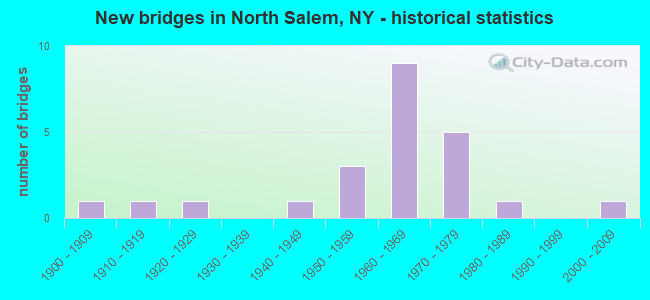
- New bridges - historical statistics
- 11900-1909
- 11910-1919
- 11920-1929
- 11940-1949
- 31950-1959
- 91960-1969
- 51970-1979
- 11980-1989
- 12000-2009

- Reconstructed bridges - Historical Statistics
- 11960-1969
- 01970-1979
- 01980-1989
- 11990-1999
- 12000-2009
- 12010-2019


- Bridge Condition - Deck
- 23.1%Good
- 61.5%Satisfactory
- 15.4%Fair

- Bridge Condition - Superstructure
- 6.7%Excellent
- 33.3%Good
- 26.7%Satisfactory
- 20.0%Fair
- 6.7%Poor
- 6.7%Serious

- Bridge Condition - Substructure
- 6.7%Very good
- 6.7%Good
- 40.0%Satisfactory
- 46.7%Fair

- Bridge Condition - Channel
- 30.0%Good
- 60.0%Satisfactory
- 10.0%Fair
Find on map >> Show street view
Structure Number: 101661, Location: JCT RTS 116 & I684 (Lat: 41.326517, Lng: -73.658119), Route carried "on" structure: State highway 116, Year Built: 1974, Status: Open, Structure Length: 5.49m (18.01ft), Average Daily Traffic: 6,780 (year 2017), Truck Traffic: 3%, Average Future Daily Traffic: 8,236 (year 2040), Design Load: HS 20, Features Intersected: 684I684I87011025, RTE I6
Minimum Vertical Clearance: 30+ m (98+ ft), Kilometerpoint: 2.108, Lanes on structure: 3, Lanes under structure: 6, Base Highway Network: Yes, Owner: State Highway Agency, Approaching Roadway Width: 12.8m (42.0ft), Skew: 20 degrees, Material/Design: Steel, Design/Construction: Stringer/Multi-beam, Number Of Spans In Main Unit: 2, Length of Maximum Span: 29.6m (97.1ft), Curb or Sidewalk Widths: Left: 0.0m, Right: 1.5m (4.9ft), Curb-To-Curb Width: 12.8m (42.0ft), Out-to-Out Width: 15.2m (49.9ft)
Condition: Deck: Satisfactory, Superstructure: Satisfactory, Substructure: Fair, Operating Rating: 62.6 metric tons, Method Used To Determine Operating Rating: Load Factor (LF), Inventory Rating: 37.2 metric tons, Method Used To Determine Inventory Rating: Load Factor (LF), Structural Evaluation: Somewhat better than minimum adequacy, Deck Geometry: Meets minimum limits, Underclear: Meets minimum limits, Approach Roadway Alignment: Equal to present desirable criteria, Length Of Structure Improvement: 5.48m (17.98ft), Designated Inspection Frequency: Every 24 months, Inspection Date: September 2020, Bridge Improvement Cost: $4,162,000, Roadway Improvement Cost: $2,437,000, Total Project Cost: $6,599,000 ( Estimate for 2021), Deck Structure Type: Concrete Cast-file-Place, Wearing Surface/Protective System: Wearing Surface: Integral Concrete
Find on map >> Show street view
Structure Number: 1016629, Location: .1 MI N JCT I684 & SH 116 (Lat: 41.327311, Lng: -73.658389), Route carried "on" structure: Interstate 684, Year Built: 1962, Year Reconstructed: 2003, Status: Open, Structure Length: 3.38m (11.09ft), Average Daily Traffic: 68,312 (year 2020), Truck Traffic: 8%, Average Future Daily Traffic: 115,679 (year 2040), Design Load: HS 20, Features Intersected: W BR TITICUS RIVER
Minimum Vertical Clearance: 30+ m (98+ ft), Kilometerpoint: 36.235, Lanes on structure: 6, Base Highway Network: Yes, Owner: State Highway Agency, Approaching Roadway Width: 32.6m (107.0ft), Skew: 30 degrees, Material/Design: Steel, Design/Construction: Stringer/Multi-beam, Number Of Spans In Main Unit: 2, Length of Maximum Span: 16.1m (52.8ft), Curb-To-Curb Width: 36.6m (120.1ft), Out-to-Out Width: 37.2m (122.0ft)
Condition: Deck: Satisfactory, Superstructure: Satisfactory, Substructure: Fair, Channel: Satisfactory, Operating Rating: 88.9 metric tons, Method Used To Determine Operating Rating: Load Factor (LF), Inventory Rating: 53.5 metric tons, Method Used To Determine Inventory Rating: Load Factor (LF), Structural Evaluation: Somewhat better than minimum adequacy, Deck Geometry: Superior to present desirable criteria, Waterway Adequacy: High priority of corrective action, Approach Roadway Alignment: Equal to present desirable criteria, Length Of Structure Improvement: 3.38m (11.09ft), Designated Inspection Frequency: Every 24 months, Inspection Date: June 2021, Bridge Improvement Cost: $5,343,000, Roadway Improvement Cost: $3,129,000, Total Project Cost: $8,471,000 ( Estimate for 2021), Deck Structure Type: Concrete Cast-file-Place, Wearing Surface/Protective System: Wearing Surface: Monolithic Concrete
Find on map >> Show street view
Structure Number: 101663, Location: 0.4 MI N JCT RTS I684+116 (Lat: 41.332681, Lng: -73.658878), Route carried "on" structure: Interstate 684, Year Built: 1962, Year Reconstructed: 1973, Status: Open, Structure Length: 1.49m (4.89ft), Average Daily Traffic: 68,312 (year 2020), Truck Traffic: 8%, Average Future Daily Traffic: 115,679 (year 2040), Design Load: H 20, Features Intersected: RTE 22
Minimum Vertical Clearance: 30+ m (98+ ft), Kilometerpoint: 36.814, Lanes on structure: 6, Lanes under structure: 2, Base Highway Network: Yes, Owner: State Highway Agency, Approaching Roadway Width: 30.5m (100.1ft), Skew: 23 degrees, Material/Design: Concrete, Design/Construction: Frame, Number Of Spans In Main Unit: 1, Length of Maximum Span: 10.3m (33.8ft), Curb-To-Curb Width: 36.7m (120.4ft), Out-to-Out Width: 37.8m (124.0ft)
Condition: Deck: Satisfactory, Superstructure: Satisfactory, Substructure: Satisfactory, Operating Rating: 64.1 metric tons, Method Used To Determine Operating Rating: Field evaluation and documented engineering judgment, Inventory Rating: 27.2 metric tons, Method Used To Determine Inventory Rating: Field evaluation and documented engineering judgment, Structural Evaluation: Equal to present minimum criteria, Deck Geometry: Superior to present desirable criteria, Underclear: High priority of corrective action, Approach Roadway Alignment: Equal to present desirable criteria, Length Of Structure Improvement: 1.49m (4.89ft), Designated Inspection Frequency: Every 24 months, Inspection Date: September 2020, Bridge Improvement Cost: $4,302,000, Roadway Improvement Cost: $2,519,000, Total Project Cost: $6,821,000 ( Estimate for 2021)
Find on map >> Show street view
Structure Number: 101737, Location: JCT OF RTS 22 + 116 (Lat: 41.327272, Lng: -73.655772), Route carried "on" structure: State highway 22, Year Built: 1977, Status: Open, Structure Length: 2.23m (7.32ft), Average Daily Traffic: 8,317 (year 2016), Truck Traffic: 3%, Average Future Daily Traffic: 8,356 (year 2040), Design Load: HS 20, Features Intersected: TITICUS RIVER
Minimum Vertical Clearance: 30+ m (98+ ft), Kilometerpoint: 58.552, Lanes on structure: 2, Base Highway Network: Yes, Owner: State Highway Agency, Approaching Roadway Width: 11.0m (36.1ft), Material/Design: Prestressed concrete, Design/Construction: Box Beam or Girders - Multiple, Number Of Spans In Main Unit: 1, Length of Maximum Span: 21.3m (69.9ft), Curb-To-Curb Width: 11.0m (36.1ft), Out-to-Out Width: 12.3m (40.4ft)
Condition: Deck: Satisfactory, Superstructure: Fair, Substructure: Fair, Channel: Good, Operating Rating: 68.9 metric tons, Method Used To Determine Operating Rating: Load Factor (LF), Inventory Rating: 23.6 metric tons, Method Used To Determine Inventory Rating: Load Factor (LF), Structural Evaluation: Somewhat better than minimum adequacy, Deck Geometry: Meets minimum limits, Waterway Adequacy: Somewhat better than minimum adequacy, Approach Roadway Alignment: Equal to present desirable criteria, Length Of Structure Improvement: 2.22m (7.28ft), Designated Inspection Frequency: Every 24 months, Inspection Date: October 2020, Bridge Improvement Cost: $813,000, Roadway Improvement Cost: $476,000, Total Project Cost: $1,289,000 ( Estimate for 2021), Wearing Surface/Protective System: Wearing Surface: Bituminous
Find on map >> Show street view
Structure Number: 10371, Location: 0.1 MI W JCT RTS 116+I684 (Lat: 41.326472, Lng: -73.659025), Route carried "on" structure: State highway 116, Year Built: 1974, Status: Open, Structure Length: 4.27m (14.01ft), Average Daily Traffic: 4,823 (year 2014), Truck Traffic: 3%, Average Future Daily Traffic: 5,858 (year 2040), Design Load: HS 20, Features Intersected: MNRR HA LINE
Minimum Vertical Clearance: 30+ m (98+ ft), Kilometerpoint: 2.011, Lanes on structure: 2, Base Highway Network: Yes, Owner: State Highway Agency, Approaching Roadway Width: 14.6m (47.9ft), Material/Design: Steel, Design/Construction: Stringer/Multi-beam, Number Of Spans In Main Unit: 1, Length of Maximum Span: 41.4m (135.8ft), Curb or Sidewalk Widths: Left: 0.0m, Right: 2.1m (6.9ft), Curb-To-Curb Width: 12.9m (42.3ft), Out-to-Out Width: 15.5m (50.9ft)
Condition: Deck: Satisfactory, Superstructure: Good, Substructure: Fair, Operating Rating: 63.2 metric tons, Method Used To Determine Operating Rating: Load and Resistance Factor Rating (LRFR) rating reported by rating factor(RF) method using HL-93 loadings, Inventory Rating: 48.9 metric tons, Method Used To Determine Inventory Rating: Load and Resistance Factor Rating (LRFR) rating reported by rating factor(RF) method using HL-93 loadings, Structural Evaluation: Somewhat better than minimum adequacy, Deck Geometry: Equal to present minimum criteria, Underclear: Somewhat better than minimum adequacy, Approach Roadway Alignment: Equal to present desirable criteria, Length Of Structure Improvement: 4.26m (13.98ft), Designated Inspection Frequency: Every 24 months, Inspection Date: September 2020, Bridge Improvement Cost: $3,187,000, Roadway Improvement Cost: $1,867,000, Total Project Cost: $5,054,000 ( Estimate for 2021), Deck Structure Type: Concrete Cast-file-Place, Wearing Surface/Protective System: Wearing Surface: Integral Concrete
Find on map >> Show street view
Structure Number: 103713, Location: 0.1 MI N JCT RTS I684+116 (Lat: 41.334831, Lng: -73.558183), Route carried "on" structure: State highway 116, Year Built: 1957, Status: Open, Structure Length: 1.43m (4.69ft), Average Daily Traffic: 3,100 (year 2015), Truck Traffic: 3%, Average Future Daily Traffic: 3,765 (year 2040), Design Load: H 20, Features Intersected: TITICUS RIVER
Minimum Vertical Clearance: 30+ m (98+ ft), Kilometerpoint: 11.730, Lanes on structure: 2, Base Highway Network: Yes, Owner: State Highway Agency, Approaching Roadway Width: 10.1m (33.1ft), Skew: 2 degrees, Material/Design: Prestressed concrete, Design/Construction: Box Beam or Girders - Multiple, Number Of Spans In Main Unit: 1, Length of Maximum Span: 13.7m (44.9ft), Curb-To-Curb Width: 10.2m (33.5ft), Out-to-Out Width: 11.7m (38.4ft)
Condition: Deck: Fair, Superstructure: Serious, Substructure: Fair, Channel: Satisfactory, Operating Rating: 55.3 metric tons, Method Used To Determine Operating Rating: Load Factor (LF), Inventory Rating: 32.7 metric tons, Method Used To Determine Inventory Rating: Load Factor (LF), Structural Evaluation: High priority of corrective action, Deck Geometry: Meets minimum limits, Waterway Adequacy: Superior to present desirable criteria, Approach Roadway Alignment: Equal to present desirable criteria, Length Of Structure Improvement: 1.43m (4.69ft), Designated Inspection Frequency: Every 12 months, Inspection Date: April 2021, Bridge Improvement Cost: $850,000, Roadway Improvement Cost: $498,000, Total Project Cost: $1,348,000 ( Estimate for 2021), Wearing Surface/Protective System: Wearing Surface: Bituminous
Find on map >> Show street view
Structure Number: 103744, Location: 1.0 MI S JCT RTS 121+116 (Lat: 41.327717, Lng: -73.580653), Route carried "on" structure: State highway 121, Year Built: 1958, Status: Open, Structure Length: 2.47m (8.10ft), Average Daily Traffic: 3,112 (year 2017), Truck Traffic: 4%, Average Future Daily Traffic: 3,780 (year 2040), Design Load: H 20, Features Intersected: TITICUS RIVER
Minimum Vertical Clearance: 30+ m (98+ ft), Kilometerpoint: 17.088, Lanes on structure: 2, Base Highway Network: Yes, Owner: State Highway Agency, Approaching Roadway Width: 10.4m (34.1ft), Skew: 4 degrees, Material/Design: Prestressed concrete, Design/Construction: Box Beam or Girders - Multiple, Number Of Spans In Main Unit: 1, Length of Maximum Span: 22.5m (73.8ft), Curb-To-Curb Width: 10.4m (34.1ft), Out-to-Out Width: 12.0m (39.4ft)
Condition: Deck: Satisfactory, Superstructure: Poor, Substructure: Fair, Channel: Satisfactory, Operating Rating: 60.8 metric tons, Method Used To Determine Operating Rating: Load Factor (LF), Inventory Rating: 34.5 metric tons, Method Used To Determine Inventory Rating: Load Factor (LF), Structural Evaluation: Meets minimum limits, Deck Geometry: Somewhat better than minimum adequacy, Waterway Adequacy: Superior to present desirable criteria, Approach Roadway Alignment: Equal to present desirable criteria, Length Of Structure Improvement: 2.46m (8.07ft), Designated Inspection Frequency: Every 24 months, Inspection Date: April 2020, Bridge Improvement Cost: $1,422,000, Roadway Improvement Cost: $833,000, Total Project Cost: $2,254,000 ( Estimate for 2021), Wearing Surface/Protective System: Wearing Surface: Bituminous
Find on map >> Show street view
Structure Number: 103748, Location: .1 MI S JCT SH121 & SH116 (Lat: 41.325908, Lng: -73.590411), Route carried "on" structure: County highway , Year Built: 1920, Status: Open, Structure Length: 0.85m (2.79ft), Average Daily Traffic: 2,321 (year 2015), Truck Traffic: 5%, Average Future Daily Traffic: 2,871 (year 2040), Features Intersected: TITICUS RIVER, Facility Carried by Structure: COUNTY ROAD 310
Minimum Vertical Clearance: 30+ m (98+ ft), Kilometerpoint: 0.821, Lanes on structure: 2, Owner: County Highway Agency, Approaching Roadway Width: 7.9m (25.9ft), Skew: 3 degrees, Material/Design: Concrete, Design/Construction: Slab, Number Of Spans In Main Unit: 1, Length of Maximum Span: 7.3m (24.0ft), Curb-To-Curb Width: 8.0m (26.2ft), Out-to-Out Width: 9.4m (30.8ft)
Condition: Deck: Good, Superstructure: Good, Substructure: Satisfactory, Channel: Satisfactory, Operating Rating: 52.8 metric tons, Method Used To Determine Operating Rating: Field evaluation and documented engineering judgment, Inventory Rating: 24.5 metric tons, Method Used To Determine Inventory Rating: Field evaluation and documented engineering judgment, Structural Evaluation: Equal to present minimum criteria, Deck Geometry: High priority of corrective action, Waterway Adequacy: Meets minimum limits, Approach Roadway Alignment: Meets minimum limits, Length Of Structure Improvement: 0.85m (2.79ft), Designated Inspection Frequency: Every 24 months, Inspection Date: June 2021, Bridge Improvement Cost: $268,000, Roadway Improvement Cost: $157,000, Total Project Cost: $426,000 ( Estimate for 2021), Wearing Surface/Protective System: Wearing Surface: Bituminous
Find on map >> Show street view
Structure Number: 105318, Location: EXIT 8 OF I684-CROTON FLS (Lat: 41.347164, Lng: -73.650453), Route carried "on" structure: County highway , Year Built: 1967, Status: Open, Structure Length: 10.24m (33.60ft), Average Daily Traffic: 7,363 (year 2017), Truck Traffic: 6%, Average Future Daily Traffic: 9,110 (year 2040), Design Load: HS 20, Features Intersected: 684I684I87011241, RTE I6, Facility Carried by Structure: HARDSCRABBLE ROAD
Minimum Vertical Clearance: 30+ m (98+ ft), Kilometerpoint: 0.611, Lanes on structure: 2, Lanes under structure: 6, Owner: State Highway Agency, Approaching Roadway Width: 8.5m (27.9ft), Skew: 5 degrees, Material/Design: Steel, Design/Construction: Stringer/Multi-beam, Number Of Spans In Main Unit: 4, Length of Maximum Span: 30.7m (100.7ft), Curb-To-Curb Width: 8.5m (27.9ft), Out-to-Out Width: 10.1m (33.1ft)
Condition: Deck: Satisfactory, Superstructure: Satisfactory, Substructure: Satisfactory, Operating Rating: 65.1 metric tons, Method Used To Determine Operating Rating: Load and Resistance Factor Rating (LRFR) rating reported by rating factor(RF) method using HL-93 loadings, Inventory Rating: 50.2 metric tons, Method Used To Determine Inventory Rating: Load and Resistance Factor Rating (LRFR) rating reported by rating factor(RF) method using HL-93 loadings, Structural Evaluation: Equal to present minimum criteria, Deck Geometry: Meets minimum limits, Underclear: High priority of corrective action, Approach Roadway Alignment: Equal to present desirable criteria, Length Of Structure Improvement: 10.24m (33.60ft), Designated Inspection Frequency: Every 24 months, Inspection Date: October 2020, Bridge Improvement Cost: $3,887,000, Roadway Improvement Cost: $2,276,000, Total Project Cost: $6,163,000 ( Estimate for 2021), Deck Structure Type: Concrete Cast-file-Place, Wearing Surface/Protective System: Wearing Surface: Integral Concrete
Find on map >> Show street view
Structure Number: 1053191, Location: 4.7 MI N JCT RTS I684+138 (Lat: 41.355211, Lng: -73.640992), Route carried "on" structure: Interstate 684, Year Built: 1964, Status: Open, Structure Length: 4.18m (13.71ft), Average Daily Traffic: 37,713 (year 2014), Truck Traffic: 7%, Design Load: H 20, Features Intersected: GUINEA RD
Minimum Vertical Clearance: 30+ m (98+ ft), Kilometerpoint: 39.758, Lanes on structure: 3, Lanes under structure: 2, Base Highway Network: Yes, Owner: State Highway Agency, Approaching Roadway Width: 15.8m (51.8ft), Skew: 1 degrees, Material/Design: Steel, Design/Construction: Stringer/Multi-beam, Number Of Spans In Main Unit: 3, Length of Maximum Span: 14.6m (47.9ft), Curb-To-Curb Width: 16.2m (53.1ft), Out-to-Out Width: 17.1m (56.1ft)
Condition: Deck: Satisfactory, Superstructure: Fair, Substructure: Satisfactory, Operating Rating: 78.0 metric tons, Method Used To Determine Operating Rating: Load Factor (LF), Inventory Rating: 46.3 metric tons, Method Used To Determine Inventory Rating: Load Factor (LF), Structural Evaluation: Somewhat better than minimum adequacy, Deck Geometry: Equal to present minimum criteria, Underclear: Meets minimum limits, Approach Roadway Alignment: Equal to present desirable criteria, Length Of Structure Improvement: 4.17m (13.68ft), Designated Inspection Frequency: Every 24 months, Inspection Date: June 2020, Bridge Improvement Cost: $2,816,000, Roadway Improvement Cost: $1,649,000, Total Project Cost: $4,466,000 ( Estimate for 2021), Deck Structure Type: Concrete Cast-file-Place, Wearing Surface/Protective System: Wearing Surface: Monolithic Concrete
Find on map >> Show street view
Structure Number: 1053192, Location: 4.7 MI N JCT RTS I684+138 (Lat: 41.355044, Lng: -73.640842), Route carried "on" structure: Interstate 684, Year Built: 1964, Status: Open, Structure Length: 4.18m (13.71ft), Average Daily Traffic: 34,156 (year 2020), Truck Traffic: 8%, Average Future Daily Traffic: 57,840 (year 2040), Design Load: H 20, Features Intersected: GUINEA RD
Minimum Vertical Clearance: 30+ m (98+ ft), Kilometerpoint: 39.791, Lanes on structure: 3, Lanes under structure: 2, Base Highway Network: Yes, Owner: State Highway Agency, Approaching Roadway Width: 15.8m (51.8ft), Skew: 1 degrees, Material/Design: Steel, Design/Construction: Stringer/Multi-beam, Number Of Spans In Main Unit: 3, Length of Maximum Span: 14.6m (47.9ft), Curb-To-Curb Width: 16.2m (53.1ft), Out-to-Out Width: 17.1m (56.1ft)
Condition: Deck: Fair, Superstructure: Fair, Substructure: Satisfactory, Operating Rating: 78.0 metric tons, Method Used To Determine Operating Rating: Load Factor (LF), Inventory Rating: 46.3 metric tons, Method Used To Determine Inventory Rating: Load Factor (LF), Structural Evaluation: Somewhat better than minimum adequacy, Deck Geometry: Equal to present minimum criteria, Underclear: Meets minimum limits, Approach Roadway Alignment: Equal to present desirable criteria, Length Of Structure Improvement: 4.17m (13.68ft), Designated Inspection Frequency: Every 24 months, Inspection Date: June 2020, Bridge Improvement Cost: $2,816,000, Roadway Improvement Cost: $1,649,000, Total Project Cost: $4,466,000 ( Estimate for 2021), Deck Structure Type: Concrete Cast-file-Place, Wearing Surface/Protective System: Wearing Surface: Monolithic Concrete
Find on map >> Show street view
Structure Number: 107755, Location: .5 MI N JCT SH 138 & I684 (Lat: 41.302961, Lng: -73.674853), Route carried "on" structure: Interstate 684, Year Built: 1972, Status: Open, Structure Length: 0.82m (2.69ft), Average Daily Traffic: 65,942 (year 2019), Truck Traffic: 8%, Average Future Daily Traffic: 111,666 (year 2040), Features Intersected: MUSCOOT RES OUTLE
Minimum Vertical Clearance: 30+ m (98+ ft), Kilometerpoint: 33.097, Lanes on structure: 6, Base Highway Network: Yes, Owner: State Highway Agency, Approaching Roadway Width: 34.1m (111.9ft), Skew: 30 degrees, Material/Design: Steel, Design/Construction: Culvert, Number Of Spans In Main Unit: 3, Length of Maximum Span: 2.1m (6.9ft)
Condition: Channel: Satisfactory, Culverts: Poor, Operating Rating: 73.1 metric tons, Method Used To Determine Operating Rating: Field evaluation and documented engineering judgment, Inventory Rating: 13.1 metric tons, Method Used To Determine Inventory Rating: Field evaluation and documented engineering judgment, Structural Evaluation: High priority of corrective action, Waterway Adequacy: High priority of replacement, Approach Roadway Alignment: Equal to present desirable criteria, Length Of Structure Improvement: 0.82m (2.69ft), Designated Inspection Frequency: Every 12 months, Underwater Inspection Frequency: Every 60 months, Inspection Date: November 2020, Underwater Inspection Date: July 2021, Bridge Improvement Cost: $791,000, Roadway Improvement Cost: $463,000, Total Project Cost: $1,255,000 ( Estimate for 2021)
Find on map >> Show street view
Structure Number: 226248, Location: 4.8 MI E OF CROTON FALLS (Lat: 41.334592, Lng: -73.570497), Route carried "on" structure: ServiceOther road , Year Built: 1987, Status: Open, Structure Length: 1.16m (3.81ft), Average Daily Traffic: 326 (year 2017), Truck Traffic: 4%, Average Future Daily Traffic: 456 (year 2037), Design Load: HS 20+Mod, Features Intersected: TITICUS RIVER, Facility Carried by Structure: KEELER LANE
Minimum Vertical Clearance: 30+ m (98+ ft), Kilometerpoint: 2.220, Lanes on structure: 1, Owner: Town or Township Highway Agency, Approaching Roadway Width: 4.6m (15.1ft), Material/Design: Prestressed concrete, Design/Construction: Box Beam or Girders - Multiple, Number Of Spans In Main Unit: 1, Length of Maximum Span: 10.6m (34.8ft), Curb-To-Curb Width: 4.7m (15.4ft), Out-to-Out Width: 6.4m (21.0ft)
Condition: Deck: Good, Superstructure: Good, Substructure: Satisfactory, Channel: Satisfactory, Operating Rating: 38.6 metric tons, Method Used To Determine Operating Rating: Load and Resistance Factor Rating (LRFR) rating reported by rating factor(RF) method using HL-93 loadings, Inventory Rating: 28.8 metric tons, Method Used To Determine Inventory Rating: Load and Resistance Factor Rating (LRFR) rating reported by rating factor(RF) method using HL-93 loadings, Structural Evaluation: Equal to present minimum criteria, Deck Geometry: High priority of replacement, Waterway Adequacy: Meets minimum limits, Approach Roadway Alignment: Equal to present desirable criteria, Length Of Structure Improvement: 1.15m (3.77ft), Designated Inspection Frequency: Every 24 months, Inspection Date: April 2021, Bridge Improvement Cost: $429,000, Roadway Improvement Cost: $251,000, Total Project Cost: $680,000 ( Estimate for 2021), Wearing Surface/Protective System: Wearing Surface: Bituminous
Find on map >> Show street view
Structure Number: 226249, Location: 5.4 MI E OF CROTON FALLS (Lat: 41.335222, Lng: -73.552758), Route carried "on" structure: Other road , Year Built: 1955, Year Reconstructed: 2012, Status: Open, Structure Length: 0.64m (2.10ft), Average Daily Traffic: 109 (year 2017), Truck Traffic: 4%, Average Future Daily Traffic: 153 (year 2037), Design Load: HS 20, Features Intersected: TITICUS RIVER, Facility Carried by Structure: NORTON LANE
Minimum Vertical Clearance: 30+ m (98+ ft), Kilometerpoint: 0.113, Lanes on structure: 2, Owner: Town or Township Highway Agency, Approaching Roadway Width: 6.4m (21.0ft), Material/Design: Steel, Design/Construction: Stringer/Multi-beam, Number Of Spans In Main Unit: 1, Length of Maximum Span: 6.0m (19.7ft), Curb-To-Curb Width: 5.5m (18.0ft), Out-to-Out Width: 6.2m (20.3ft)
Condition: Deck: Good, Superstructure: Good, Substructure: Fair, Channel: Fair, Operating Rating: 21.4 metric tons, Method Used To Determine Operating Rating: Load and Resistance Factor Rating (LRFR) rating reported by rating factor(RF) method using HL-93 loadings, Inventory Rating: 16.5 metric tons, Method Used To Determine Inventory Rating: Load and Resistance Factor Rating (LRFR) rating reported by rating factor(RF) method using HL-93 loadings, Structural Evaluation: Somewhat better than minimum adequacy, Deck Geometry: High priority of corrective action, Waterway Adequacy: Meets minimum limits, Approach Roadway Alignment: Better than present minimum criteria, Length Of Structure Improvement: 0.64m (2.10ft), Designated Inspection Frequency: Every 24 months, Inspection Date: June 2020, Bridge Improvement Cost: $423,000, Roadway Improvement Cost: $248,000, Total Project Cost: $670,000 ( Estimate for 2021), Deck Structure Type: Wood or Timber, Wearing Surface/Protective System: Wearing Surface: Wood or Timber
Find on map >> Show street view
Structure Number: 226535, Location: E OF SALEM CTR OFF RT 116 (Lat: 41.328589, Lng: -73.599175), Route carried "on" structure: Other road , Year Built: 2001, Status: Open, Structure Length: 1.16m (3.81ft), Truck Traffic: 5%, Features Intersected: TITICUS CREEK, Facility Carried by Structure: MILLS ROAD
Minimum Vertical Clearance: 30+ m (98+ ft), Kilometerpoint: 5.664, Lanes on structure: 2, Owner: Local Agency, Approaching Roadway Width: 7.6m (24.9ft), Material/Design: Concrete, Design/Construction: Arch - Deck, Number Of Spans In Main Unit: 1, Length of Maximum Span: 11.2m (36.7ft), Curb-To-Curb Width: 7.8m (25.6ft), Out-to-Out Width: 8.7m (28.5ft)
Condition: Superstructure: Excellent, Substructure: Very good, Channel: Good, Operating Rating: 80.6 metric tons, Method Used To Determine Operating Rating: Field evaluation and documented engineering judgment, Inventory Rating: 40.8 metric tons, Method Used To Determine Inventory Rating: Field evaluation and documented engineering judgment, Structural Evaluation: Equal to present desirable criteria, Deck Geometry: Equal to present minimum criteria, Waterway Adequacy: Somewhat better than minimum adequacy, Approach Roadway Alignment: Equal to present minimum criteria, Length Of Structure Improvement: 1.15m (3.77ft), Designated Inspection Frequency: Every 24 months, Inspection Date: July 2021, Bridge Improvement Cost: $815,000, Roadway Improvement Cost: $477,000, Total Project Cost: $1,292,000 ( Estimate for 2021), Wearing Surface/Protective System: Wearing Surface: Bituminous
Find on map >> Show street view
Structure Number: 334858, Location: AT CROTON FALLS (Lat: 41.350556, Lng: -73.664753), Route carried "on" structure: County highway , Year Built: 1908, Year Reconstructed: 2015, Status: Open, Structure Length: 3.44m (11.29ft), Average Daily Traffic: 7,487 (year 2015), Truck Traffic: 3%, Average Future Daily Traffic: 9,263 (year 2040), Features Intersected: CROTON RIVER, Facility Carried by Structure: CROTON FALLS ROAD
Minimum Vertical Clearance: 30+ m (98+ ft), Kilometerpoint: 0.000, Lanes on structure: 2, Owner: County Highway Agency, Approaching Roadway Width: 8.5m (27.9ft), Material/Design: Concrete, Design/Construction: Arch - Deck, Number Of Spans In Main Unit: 1, Length of Maximum Span: 30.4m (99.7ft), Curb or Sidewalk Widths: Left: 1.8m (5.9ft), Right: 0.0m, Curb-To-Curb Width: 8.3m (27.2ft), Out-to-Out Width: 10.9m (35.8ft)
Condition: Superstructure: Good, Substructure: Good, Channel: Good, Operating Rating: 57.5 metric tons, Method Used To Determine Operating Rating: Field evaluation and documented engineering judgment, Inventory Rating: 20.0 metric tons, Method Used To Determine Inventory Rating: Field evaluation and documented engineering judgment, Structural Evaluation: Somewhat better than minimum adequacy, Deck Geometry: High priority of replacement, Waterway Adequacy: Somewhat better than minimum adequacy, Approach Roadway Alignment: Better than present minimum criteria, Length Of Structure Improvement: 3.44m (11.29ft), Designated Inspection Frequency: Every 24 months, Inspection Date: May 2021, Bridge Improvement Cost: $3,190,000, Roadway Improvement Cost: $1,868,000, Total Project Cost: $5,057,000 ( Estimate for 2021)
Find on map >> Show street view
Structure Number: 101661, Location: JCT RTS 116 & I684 (Lat: 41.326517, Lng: -73.658119), Route carried "under" structure: Interstate 684, Year Built: 1974, Structure Length: 0. m, Average Daily Traffic: 67,331 (year 2002), Features Intersected: 684I684I87011025, RTE I6, Facility Carried by Structure: RTE 116
Minimum Vertical Clearance: 7.01m (23.00ft), Kilometerpoint: 36.203, Lanes on structure: 3, Lanes under structure: 3, Material/Design: Steel, Design/Construction: Stringer/Multi-beam, Length of Maximum Span: 29.6m (97.1ft)
Find on map >> Show street view
Structure Number: 101663, Location: 0.4 MI N JCT RTS I684+116 (Lat: 41.332681, Lng: -73.658878), Route carried "under" structure: Alternate State highway 22, Year Built: 1962, Structure Length: 0. m, Average Daily Traffic: 11,744 (year 1998), Features Intersected: RTE 22, Facility Carried by Structure: RTE I684
Minimum Vertical Clearance: 4.45m (14.60ft), Kilometerpoint: 40.611, Lanes on structure: 6, Lanes under structure: 2, Material/Design: Concrete, Design/Construction: Frame, Length of Maximum Span: 10.3m (33.8ft)
Find on map >> Show street view
Structure Number: 105318, Location: EXIT 8 OF I684-CROTON FLS (Lat: 41.347164, Lng: -73.650453), Route carried "under" structure: Interstate 684, Year Built: 1967, Structure Length: 0. m, Average Daily Traffic: 67,331 (year 2002), Features Intersected: 684I684I87011241, RTE I6, Facility Carried by Structure: HARDSCRABBLE ROAD
Minimum Vertical Clearance: 5.18m (16.99ft), Kilometerpoint: 38.777, Lanes on structure: 2, Lanes under structure: 3, Material/Design: Steel, Design/Construction: Stringer/Multi-beam, Length of Maximum Span: 30.7m (100.7ft)
Find on map >> Show street view
Structure Number: 1053191, Location: 4.7 MI N JCT RTS I684+138 (Lat: 41.355211, Lng: -73.640992), Route carried "under" structure: Other road , Year Built: 1964, Structure Length: 0. m, Features Intersected: GUINEA RD, Facility Carried by Structure: RTE I684
Minimum Vertical Clearance: 4.59m (15.06ft), Kilometerpoint: 0.000, Lanes on structure: 3, Lanes under structure: 2, Material/Design: Steel, Design/Construction: Stringer/Multi-beam, Length of Maximum Span: 14.6m (47.9ft)
Find on map >> Show street view
Structure Number: 1053192, Location: 4.7 MI N JCT RTS I684+138 (Lat: 41.355044, Lng: -73.640842), Route carried "under" structure: Other road , Year Built: 1964, Structure Length: 0. m, Features Intersected: GUINEA RD, Facility Carried by Structure: RTE I684
Minimum Vertical Clearance: 4.69m (15.39ft), Kilometerpoint: 0.032, Lanes on structure: 3, Lanes under structure: 2, Material/Design: Steel, Design/Construction: Stringer/Multi-beam, Length of Maximum Span: 14.6m (47.9ft)
Find on map >> Show street view
Structure Number: 701665, Location: JCT RR&RTE 22 CROTON FALL (Lat: 41.348956, Lng: -73.662442), Route carried "under" structure: State highway 22, Year Built: 1915, Structure Length: 0. m, Average Daily Traffic: 6,000 (year 1972), Features Intersected: RTE 22, Facility Carried by Structure: MNRR HA LINE
Minimum Vertical Clearance: 4.47m (14.67ft), Kilometerpoint: 44.038, Lanes under structure: 2, Material/Design: Steel, Design/Construction: Girder and Floorbeam System, Length of Maximum Span: 13.7m (44.9ft)
Find on map >> Show street view
Structure Number: 701666, Location: 0.34MI NE JCT RTS 22&202 (Lat: 41.354058, Lng: -73.661486), Route carried "under" structure: State highway 22, Year Built: 1940, Structure Length: 0. m, Average Daily Traffic: 100 (year 2021), Features Intersected: RTE 22, Facility Carried by Structure: MNRR HA LINE
Minimum Vertical Clearance: 4.26m (13.98ft), Kilometerpoint: 0.000, Lanes under structure: 4, Material/Design: Steel continuous, Design/Construction: Stringer/Multi-beam, Length of Maximum Span: 9.4m (30.8ft)