Bridge Statistics for Northville, Michigan (MI)
Condition, Traffic, Stress, Structural Evaluation, Project Costs
- National Bridge Inventory (NBI) Statistics
- 25Number of bridges
- 135ft / 41.4mTotal length
- $360,000Total costs
- 240,710Total average daily traffic
- 13,128Total average daily truck traffic
- National Bridge Inventory (NBI) Registered Bridges for Northville
- No street view available for this location
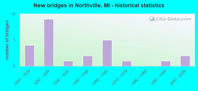
- New bridges - historical statistics
- 41920-1929
- 91930-1939
- 11940-1949
- 21950-1959
- 51960-1969
- 11970-1979
- 11990-1999
- 22000-2009
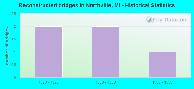
- Reconstructed bridges - Historical Statistics
- 21970-1979
- 21980-1989
- 11990-1999
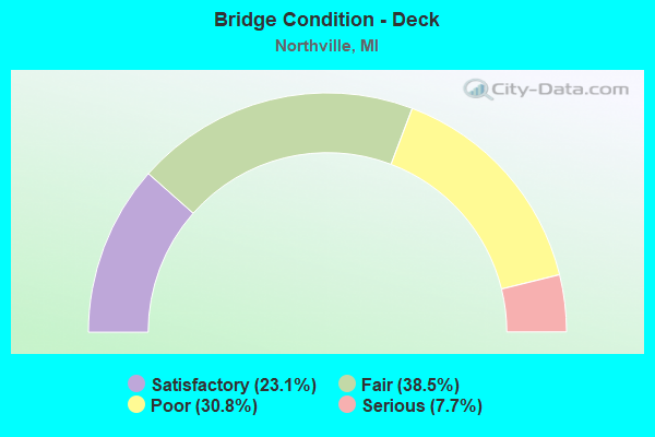
- Bridge Condition - Deck
- 23.1%Satisfactory
- 38.5%Fair
- 30.8%Poor
- 7.7%Serious
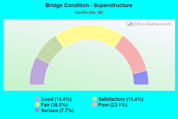
- Bridge Condition - Superstructure
- 15.4%Good
- 15.4%Satisfactory
- 38.5%Fair
- 23.1%Poor
- 7.7%Serious
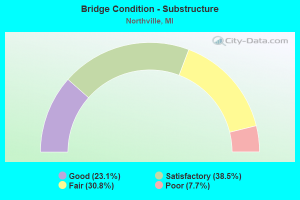
- Bridge Condition - Substructure
- 23.1%Good
- 38.5%Satisfactory
- 30.8%Fair
- 7.7%Poor
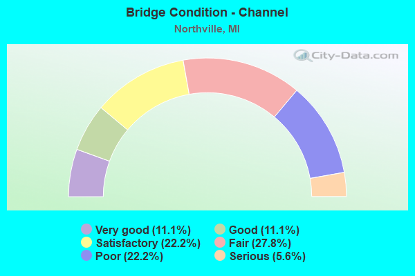
- Bridge Condition - Channel
- 11.1%Very good
- 11.1%Good
- 22.2%Satisfactory
- 27.8%Fair
- 22.2%Poor
- 5.6%Serious
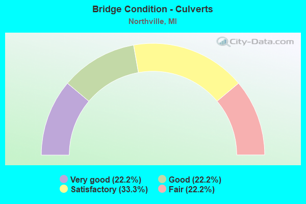
- Bridge Condition - Culverts
- 22.2%Very good
- 22.2%Good
- 33.3%Satisfactory
- 22.2%Fair
Find on map >> Show street view
Structure Number: 121, Location: 2.0 MI NE OF SAUGATUCK (Lat: 42.682314, Lng: -86.169836), Route carried "on" structure: County highway 303, Year Built: 1964, Status: Open, Structure Length: 8.44m (27.69ft), Average Daily Traffic: 9,016 (year 1996), Truck Traffic: 3%, Average Future Daily Traffic: 4,550 (year 1977), Design Load: HS 20, Features Intersected: I-196 & US-31, Facility Carried by Structure: OLD US-31
Minimum Vertical Clearance: 30.48m (100.00ft), Kilometerpoint: 11.499, Lanes on structure: 2, Lanes under structure: 6, Owner: State Highway Agency, Approaching Roadway Width: 13.0m (42.7ft), Skew: 3 degrees, Material/Design: Steel, Design/Construction: Stringer/Multi-beam, Number Of Spans In Main Unit: 4, Length of Maximum Span: 28.8m (94.5ft), Curb or Sidewalk Widths: Left: 0.2m (0.7ft), Right: 0.2m (0.7ft), Curb-To-Curb Width: 9.1m (29.9ft), Out-to-Out Width: 11.4m (37.4ft)
Condition: Deck: Fair, Superstructure: Fair, Substructure: Poor, Operating Rating: 71.3 metric tons, Method Used To Determine Operating Rating: Load Factor (LF) rating reported by rating factor (RF) method using MS18 loading, Inventory Rating: 42.8 metric tons, Method Used To Determine Inventory Rating: Load Factor (LF) rating reported by rating factor (RF) method using MS18 loading, Structural Evaluation: Meets minimum limits, Deck Geometry: Meets minimum limits, Underclear: Somewhat better than minimum adequacy, Approach Roadway Alignment: Equal to present desirable criteria, Designated Inspection Frequency: Every 12 months, Inspection Date: May 2021, Deck Structure Type: Concrete Cast-file-Place, Wearing Surface/Protective System: Wearing Surface: Monolithic Concrete
Find on map >> Show street view
Structure Number: 8245, Location: 0.15 MI E OF OAKLAND AVE (Lat: 42.438075, Lng: -83.473369), Route carried "on" structure: City street , Year Built: 1994, Status: Open, Structure Length: 1.06m (3.48ft), Average Daily Traffic: 500 (year 1989), Truck Traffic: 7%, Average Future Daily Traffic: 600 (year 2013), Design Load: HS 20+Mod, Features Intersected: MIDDLE RIVER ROUGE, Facility Carried by Structure: OLD NOVI ROAD
Minimum Vertical Clearance: 30.48m (100.00ft), Kilometerpoint: 0.048, Lanes on structure: 2, Owner: City or Municipal Highway Agency, Approaching Roadway Width: 9.1m (29.9ft), Skew: 2 degrees, Material/Design: Concrete, Design/Construction: Culvert, Number Of Spans In Main Unit: 1, Length of Maximum Span: 9.7m (31.8ft), Curb-To-Curb Width: 8.2m (26.9ft), Out-to-Out Width: 14.6m (47.9ft)
Condition: Channel: Satisfactory, Culverts: Good, Operating Rating: 54.6 metric tons, Method Used To Determine Operating Rating: Field evaluation and documented engineering judgment, Inventory Rating: 32.7 metric tons, Method Used To Determine Inventory Rating: Field evaluation and documented engineering judgment, Structural Evaluation: Better than present minimum criteria, Deck Geometry: Somewhat better than minimum adequacy, Waterway Adequacy: Equal to present desirable criteria, Approach Roadway Alignment: Equal to present desirable criteria, Designated Inspection Frequency: Every 24 months, Inspection Date: April 2020, Wearing Surface/Protective System: Wearing Surface: Bituminous
Find on map >> Show street view
Structure Number: 12085, Location: NORTHVILLE TWP W/BECK (Lat: 42.408294, Lng: -83.516853), Route carried "on" structure: County highway 8292, Year Built: 1935, Year Reconstructed: 2003, Status: Open, Structure Length: 0.98m (3.22ft), Average Daily Traffic: 6,222 (year 2019), Truck Traffic: 4%, Average Future Daily Traffic: 6,875 (year 2039), Design Load: HS 25 or greater, Features Intersected: JOHNSON DRAIN, Facility Carried by Structure: SIX MILE ROAD
Minimum Vertical Clearance: 30.48m (100.00ft), Kilometerpoint: 2.762, Lanes on structure: 2, Owner: County Highway Agency, Approaching Roadway Width: 10.9m (35.8ft), Material/Design: Concrete, Design/Construction: Culvert, Number Of Spans In Main Unit: 1, Length of Maximum Span: 9.8m (32.2ft), Curb or Sidewalk Widths: Left: 0.5m (1.6ft), Right: 0.5m (1.6ft), Curb-To-Curb Width: 12.2m (40.0ft), Out-to-Out Width: 13.2m (43.3ft)
Condition: Channel: Very good, Culverts: Very good, Operating Rating: 55.7 metric tons, Method Used To Determine Operating Rating: Load Factor (LF) rating reported by rating factor (RF) method using MS18 loading, Inventory Rating: 46.0 metric tons, Method Used To Determine Inventory Rating: Load Factor (LF) rating reported by rating factor (RF) method using MS18 loading, Structural Evaluation: Equal to present desirable criteria, Deck Geometry: Somewhat better than minimum adequacy, Waterway Adequacy: Better than present minimum criteria, Approach Roadway Alignment: Equal to present desirable criteria, Designated Inspection Frequency: Every 16 months, Inspection Date: January 2022
Find on map >> Show street view
Structure Number: 12086, Location: NORTHVILLE T W/NORTHV RD (Lat: 42.410892, Lng: -83.470822), Route carried "on" structure: County highway 2057, Year Built: 1933, Status: Posted for load, Structure Length: 1.82m (5.97ft), Average Daily Traffic: 9,326 (year 1997), Truck Traffic: 5%, Average Future Daily Traffic: 12,000 (year 2015), Design Load: H 20, Features Intersected: MIDDLE ROUGE RIVER, Facility Carried by Structure: SIX MILE ROAD
Minimum Vertical Clearance: 30.48m (100.00ft), Kilometerpoint: 6.565, Lanes on structure: 4, Owner: County Highway Agency, Approaching Roadway Width: 12.2m (40.0ft), Material/Design: Concrete, Design/Construction: Frame, Number Of Spans In Main Unit: 1, Length of Maximum Span: 16.4m (53.8ft), Curb or Sidewalk Widths: Left: 1.8m (5.9ft), Right: 1.8m (5.9ft), Curb-To-Curb Width: 12.2m (40.0ft), Out-to-Out Width: 17.0m (55.8ft)
Condition: Deck: Satisfactory, Superstructure: Satisfactory, Substructure: Good, Channel: Satisfactory, Operating Rating: 29.8 metric tons, Method Used To Determine Operating Rating: Load Factor (LF) rating reported by rating factor (RF) method using MS18 loading, Inventory Rating: 17.2 metric tons, Method Used To Determine Inventory Rating: Load Factor (LF) rating reported by rating factor (RF) method using MS18 loading, Structural Evaluation: Meets minimum limits, Deck Geometry: High priority of replacement, Waterway Adequacy: Equal to present desirable criteria, Approach Roadway Alignment: Equal to present desirable criteria, Bridge Posting: Required (Relationship of Operating Rating to Maximum Legal Load: > 39.9% below), Designated Inspection Frequency: Every 24 months, Inspection Date: May 2021, Deck Structure Type: Concrete Cast-file-Place, Wearing Surface/Protective System: Wearing Surface: Bituminous
Find on map >> Show street view
Structure Number: 12087, Location: NORTHVILLE T W/NORTHV RD (Lat: 42.410653, Lng: -83.471922), Route carried "on" structure: County highway 2057, Year Built: 1933, Status: Posted for load, Structure Length: 2.04m (6.69ft), Average Daily Traffic: 9,326 (year 1997), Truck Traffic: 5%, Average Future Daily Traffic: 12,000 (year 2015), Design Load: HS 20+Mod, Features Intersected: EN HINES DRIVE, Facility Carried by Structure: SIX MILE ROAD
Minimum Vertical Clearance: 30.48m (100.00ft), Kilometerpoint: 6.470, Lanes on structure: 2, Lanes under structure: 2, Owner: County Highway Agency, Approaching Roadway Width: 14.0m (45.9ft), Material/Design: Concrete, Design/Construction: Frame, Number Of Spans In Main Unit: 1, Length of Maximum Span: 18.2m (59.7ft), Curb or Sidewalk Widths: Left: 1.9m (6.2ft), Right: 1.9m (6.2ft), Curb-To-Curb Width: 12.2m (40.0ft), Out-to-Out Width: 16.4m (53.8ft)
Condition: Deck: Fair, Superstructure: Poor, Substructure: Satisfactory, Operating Rating: 25.6 metric tons, Method Used To Determine Operating Rating: Load Factor (LF) rating reported by rating factor (RF) method using MS18 loading, Inventory Rating: 15.2 metric tons, Method Used To Determine Inventory Rating: Load Factor (LF) rating reported by rating factor (RF) method using MS18 loading, Structural Evaluation: High priority of corrective action, Deck Geometry: Somewhat better than minimum adequacy, Underclear: Equal to present minimum criteria, Approach Roadway Alignment: Equal to present desirable criteria, Bridge Posting: Required (Relationship of Operating Rating to Maximum Legal Load: > 39.9% below), Designated Inspection Frequency: Every 12 months, Inspection Date: May 2021, Deck Structure Type: Concrete Cast-file-Place, Wearing Surface/Protective System: Wearing Surface: Bituminous
Find on map >> Show street view
Structure Number: 12093, Location: NORTHVILLE T E/BECK (Lat: 42.423383, Lng: -83.504122), Route carried "on" structure: County highway 2057, Year Built: 1934, Status: Open, Structure Length: 0.64m (2.10ft), Average Daily Traffic: 6,799 (year 1995), Truck Traffic: 5%, Average Future Daily Traffic: 6,092 (year 2015), Features Intersected: N/BRANCH JOHNSON DRAIN, Facility Carried by Structure: SEVEN MILE ROAD
Minimum Vertical Clearance: 30.48m (100.00ft), Kilometerpoint: 3.877, Lanes on structure: 2, Owner: County Highway Agency, Approaching Roadway Width: 11.6m (38.1ft), Material/Design: Concrete, Design/Construction: Culvert, Number Of Spans In Main Unit: 1, Length of Maximum Span: 5.4m (17.7ft), Curb or Sidewalk Widths: Left: 0.2m (0.7ft), Right: 0.2m (0.7ft), Curb-To-Curb Width: 11.3m (37.1ft), Out-to-Out Width: 11.7m (38.4ft)
Condition: Channel: Good, Culverts: Satisfactory, Operating Rating: 51.5 metric tons, Method Used To Determine Operating Rating: Load Factor (LF) rating reported by rating factor (RF) method using MS18 loading, Inventory Rating: 44.7 metric tons, Method Used To Determine Inventory Rating: Load Factor (LF) rating reported by rating factor (RF) method using MS18 loading, Structural Evaluation: Equal to present minimum criteria, Deck Geometry: Meets minimum limits, Waterway Adequacy: Equal to present desirable criteria, Approach Roadway Alignment: Equal to present desirable criteria, Designated Inspection Frequency: Every 24 months, Inspection Date: May 2021
Find on map >> Show street view
Structure Number: 12094, Location: NORTHVILLE W/NORTHVILL RD (Lat: 42.425542, Lng: -83.477889), Route carried "on" structure: County highway 2057, Year Built: 1954, Status: Open, Structure Length: 1.98m (6.50ft), Average Daily Traffic: 7,853 (year 1995), Truck Traffic: 3%, Average Future Daily Traffic: 6,640 (year 2015), Design Load: HS 20, Features Intersected: MIDDLE ROUGE RIVER, Facility Carried by Structure: SEVEN MILE ROAD
Minimum Vertical Clearance: 30.48m (100.00ft), Kilometerpoint: 0.222, Lanes on structure: 2, Owner: County Highway Agency, Approaching Roadway Width: 13.4m (44.0ft), Material/Design: Concrete continuous, Design/Construction: Slab, Number Of Spans In Main Unit: 3, Length of Maximum Span: 7.3m (24.0ft), Curb or Sidewalk Widths: Left: 1.2m (3.9ft), Right: 1.2m (3.9ft), Curb-To-Curb Width: 13.4m (44.0ft), Out-to-Out Width: 16.4m (53.8ft)
Condition: Deck: Fair, Superstructure: Fair, Substructure: Fair, Channel: Poor, Operating Rating: 86.8 metric tons, Method Used To Determine Operating Rating: Load Factor (LF) rating reported by rating factor (RF) method using MS18 loading, Inventory Rating: 51.8 metric tons, Method Used To Determine Inventory Rating: Load Factor (LF) rating reported by rating factor (RF) method using MS18 loading, Structural Evaluation: Somewhat better than minimum adequacy, Deck Geometry: Equal to present minimum criteria, Waterway Adequacy: Equal to present desirable criteria, Approach Roadway Alignment: Equal to present desirable criteria, Designated Inspection Frequency: Every 24 months, Inspection Date: May 2021, Deck Structure Type: Concrete Cast-file-Place, Wearing Surface/Protective System: Wearing Surface: Bituminous
Find on map >> Show street view
Structure Number: 12099, Location: NORTHVILLE E/CENTER (Lat: 42.439800, Lng: -83.476050), Route carried "on" structure: County highway 2057, Year Built: 1960, Status: Open, Structure Length: 1.46m (4.79ft), Average Daily Traffic: 18,988 (year 1996), Truck Traffic: 8%, Average Future Daily Traffic: 17,675 (year 2015), Design Load: HS 20+Mod, Features Intersected: MIDDLE ROUGE RIVER, Facility Carried by Structure: BASE LINE/NOVI RD
Minimum Vertical Clearance: 30.48m (100.00ft), Kilometerpoint: 1.403, Lanes on structure: 6, Owner: County Highway Agency, Approaching Roadway Width: 20.7m (67.9ft), Material/Design: Steel, Design/Construction: Culvert, Number Of Spans In Main Unit: 3, Length of Maximum Span: 3.7m (12.1ft), Out-to-Out Width: 76.2m (250.0ft)
Condition: Channel: Fair, Culverts: Fair, Operating Rating: 97.2 metric tons, Method Used To Determine Operating Rating: Load Factor (LF) rating reported by rating factor (RF) method using MS18 loading, Inventory Rating: 97.2 metric tons, Method Used To Determine Inventory Rating: Load Factor (LF) rating reported by rating factor (RF) method using MS18 loading, Structural Evaluation: Somewhat better than minimum adequacy, Waterway Adequacy: Equal to present desirable criteria, Approach Roadway Alignment: Equal to present desirable criteria, Designated Inspection Frequency: Every 24 months, Inspection Date: May 2021
Find on map >> Show street view
Structure Number: 12101, Location: NORTHVILLE E/NOVI RD (Lat: 42.439861, Lng: -83.474528), Route carried "on" structure: County highway 2057, Year Built: 1960, Status: Open, Structure Length: 5.49m (18.01ft), Average Daily Traffic: 35,730 (year 2015), Truck Traffic: 12%, Average Future Daily Traffic: 37,880 (year 2035), Design Load: HS 20+Mod, Features Intersected: CSX RR, Facility Carried by Structure: BASE LINE
Minimum Vertical Clearance: 30.48m (100.00ft), Kilometerpoint: 1.518, Lanes on structure: 4, Owner: County Highway Agency, Approaching Roadway Width: 15.8m (51.8ft), Skew: 1 degrees, Material/Design: Steel continuous, Design/Construction: Stringer/Multi-beam, Number Of Spans In Main Unit: 3, Length of Maximum Span: 21.9m (71.9ft), Curb or Sidewalk Widths: Left: 1.5m (4.9ft), Right: 1.5m (4.9ft), Curb-To-Curb Width: 15.8m (51.8ft), Out-to-Out Width: 19.5m (64.0ft)
Condition: Deck: Serious, Superstructure: Good, Substructure: Good, Operating Rating: 66.4 metric tons, Method Used To Determine Operating Rating: Load Factor (LF) rating reported by rating factor (RF) method using MS18 loading, Inventory Rating: 37.6 metric tons, Method Used To Determine Inventory Rating: Load Factor (LF) rating reported by rating factor (RF) method using MS18 loading, Structural Evaluation: Better than present minimum criteria, Deck Geometry: Meets minimum limits, Underclear: Equal to present desirable criteria, Approach Roadway Alignment: Equal to present desirable criteria, Designated Inspection Frequency: Every 12 months, Inspection Date: April 2021, Deck Structure Type: Concrete Cast-file-Place, Wearing Surface/Protective System: Wearing Surface: Epoxy Overlay, Deck Protection: Epoxy Coated Reinforcing
Find on map >> Show street view
Structure Number: 12107, Location: NORTHVILLE T N/SIX MILE (Lat: 42.411928, Lng: -83.511181), Route carried "on" structure: County highway 2057, Year Built: 1930, Year Reconstructed: 1989, Status: Posted for load, Structure Length: 0.85m (2.79ft), Average Daily Traffic: 16,972 (year 1997), Truck Traffic: 3%, Average Future Daily Traffic: 16,009 (year 2015), Features Intersected: JOHNSON DRAIN, Facility Carried by Structure: BECK ROAD
Minimum Vertical Clearance: 30.48m (100.00ft), Kilometerpoint: 16.073, Lanes on structure: 2, Owner: County Highway Agency, Approaching Roadway Width: 12.2m (40.0ft), Material/Design: Concrete, Design/Construction: Tee Beam, Number Of Spans In Main Unit: 1, Length of Maximum Span: 7.6m (24.9ft), Curb-To-Curb Width: 11.5m (37.7ft), Out-to-Out Width: 12.5m (41.0ft)
Condition: Deck: Poor, Superstructure: Fair, Substructure: Satisfactory, Channel: Satisfactory, Operating Rating: 36.9 metric tons, Method Used To Determine Operating Rating: Load Factor (LF) rating reported by rating factor (RF) method using MS18 loading, Inventory Rating: 22.0 metric tons, Method Used To Determine Inventory Rating: Load Factor (LF) rating reported by rating factor (RF) method using MS18 loading, Structural Evaluation: Somewhat better than minimum adequacy, Deck Geometry: Meets minimum limits, Waterway Adequacy: Equal to present desirable criteria, Approach Roadway Alignment: Equal to present desirable criteria, Bridge Posting: Required (Relationship of Operating Rating to Maximum Legal Load: 20.0 - 29.9% below), Designated Inspection Frequency: Every 12 months, Inspection Date: May 2021, Deck Structure Type: Concrete Cast-file-Place, Wearing Surface/Protective System: Wearing Surface: Integral Concrete, Deck Protection: Epoxy Coated Reinforcing
Find on map >> Show street view
Structure Number: 12114, Location: NORTHVILLE S/E N HINES DR (Lat: 42.425475, Lng: -83.482589), Route carried "on" structure: County highway 2057, Year Built: 1933, Status: Open, Structure Length: 1.18m (3.87ft), Average Daily Traffic: 10,057 (year 1997), Truck Traffic: 3%, Average Future Daily Traffic: 11,719 (year 2015), Design Load: H 20, Features Intersected: JOHNSON DRAIN, Facility Carried by Structure: SHELDON ROAD
Minimum Vertical Clearance: 30.48m (100.00ft), Kilometerpoint: 8.778, Lanes on structure: 2, Base Highway Network: Yes (Inventory Route: 549, Subroute: 71), Owner: County Highway Agency, Approaching Roadway Width: 10.9m (35.8ft), Material/Design: Concrete, Design/Construction: Culvert, Number Of Spans In Main Unit: 2, Length of Maximum Span: 5.4m (17.7ft), Curb-To-Curb Width: 12.2m (40.0ft), Out-to-Out Width: 13.1m (43.0ft)
Condition: Channel: Poor, Culverts: Satisfactory, Operating Rating: 85.9 metric tons, Method Used To Determine Operating Rating: Load Factor (LF) rating reported by rating factor (RF) method using MS18 loading, Inventory Rating: 51.5 metric tons, Method Used To Determine Inventory Rating: Load Factor (LF) rating reported by rating factor (RF) method using MS18 loading, Structural Evaluation: Equal to present minimum criteria, Deck Geometry: Somewhat better than minimum adequacy, Waterway Adequacy: Better than present minimum criteria, Approach Roadway Alignment: Equal to present minimum criteria, Designated Inspection Frequency: Every 24 months, Inspection Date: June 2021
Find on map >> Show street view
Structure Number: 12115, Location: NORTHVILLE E/SHELDON (Lat: 42.425667, Lng: -83.481056), Route carried "on" structure: County highway 2057, Year Built: 1932, Year Reconstructed: 1978, Status: Open, Structure Length: 1.03m (3.38ft), Average Daily Traffic: 10,904 (year 1996), Truck Traffic: 5%, Average Future Daily Traffic: 6,666 (year 2015), Design Load: HS 20+Mod, Features Intersected: MIDDLE ROUGE RIVER, Facility Carried by Structure: E N HINES DRIVE
Minimum Vertical Clearance: 30.48m (100.00ft), Kilometerpoint: 2.932, Lanes on structure: 4, Base Highway Network: Yes (Inventory Route: 470, Subroute: 16), Owner: County Highway Agency, Approaching Roadway Width: 16.4m (53.8ft), Material/Design: Concrete, Design/Construction: Tee Beam, Number Of Spans In Main Unit: 1, Length of Maximum Span: 9.1m (29.9ft), Curb or Sidewalk Widths: Left: 1.7m (5.6ft), Right: 1.7m (5.6ft), Curb-To-Curb Width: 12.2m (40.0ft), Out-to-Out Width: 16.1m (52.8ft)
Condition: Deck: Satisfactory, Superstructure: Fair, Substructure: Satisfactory, Channel: Good, Operating Rating: 62.9 metric tons, Method Used To Determine Operating Rating: Load Factor (LF) rating reported by rating factor (RF) method using MS18 loading, Inventory Rating: 37.6 metric tons, Method Used To Determine Inventory Rating: Load Factor (LF) rating reported by rating factor (RF) method using MS18 loading, Structural Evaluation: Somewhat better than minimum adequacy, Deck Geometry: High priority of replacement, Waterway Adequacy: Equal to present desirable criteria, Approach Roadway Alignment: Equal to present desirable criteria, Designated Inspection Frequency: Every 24 months, Inspection Date: April 2021, Deck Structure Type: Concrete Cast-file-Place, Wearing Surface/Protective System: Wearing Surface: Integral Concrete
Find on map >> Show street view
Structure Number: 12116, Location: NORTHVILLE N/MAIN ST (Lat: 42.432625, Lng: -83.478867), Route carried "on" structure: County highway 2057, Year Built: 1928, Status: Open, Structure Length: 0.73m (2.40ft), Average Daily Traffic: 5,403 (year 1993), Truck Traffic: 2%, Average Future Daily Traffic: 6,484 (year 2015), Design Load: H 20, Features Intersected: MIDDLE ROUGE RIVER, Facility Carried by Structure: GRISWOLD STREET
Minimum Vertical Clearance: 30.48m (100.00ft), Kilometerpoint: 0.409, Lanes on structure: 4, Owner: County Highway Agency, Approaching Roadway Width: 10.9m (35.8ft), Material/Design: Concrete, Design/Construction: Culvert, Number Of Spans In Main Unit: 2, Length of Maximum Span: 3.0m (9.8ft), Curb or Sidewalk Widths: Left: 0.0m, Right: 1.8m (5.9ft), Curb-To-Curb Width: 10.9m (35.8ft), Out-to-Out Width: 19.0m (62.3ft)
Condition: Channel: Fair, Culverts: Satisfactory, Operating Rating: 22.2 metric tons, Method Used To Determine Operating Rating: Field evaluation and documented engineering judgment, Inventory Rating: 13.4 metric tons, Method Used To Determine Inventory Rating: Field evaluation and documented engineering judgment, Structural Evaluation: High priority of corrective action, Deck Geometry: High priority of replacement, Waterway Adequacy: Equal to present desirable criteria, Approach Roadway Alignment: Equal to present desirable criteria, Designated Inspection Frequency: Every 24 months, Inspection Date: May 2021
Find on map >> Show street view
Structure Number: 12117, Location: NORTHVILLE S/BASE LINE (Lat: 42.435075, Lng: -83.476178), Route carried "on" structure: County highway 2057, Year Built: 2001, Status: Open, Structure Length: 1.95m (6.40ft), Average Daily Traffic: 9,704 (year 1999), Truck Traffic: 1%, Average Future Daily Traffic: 6,484 (year 2015), Design Load: HS 25 or greater, Features Intersected: CSX RR, Facility Carried by Structure: GRISWOLD STREET
Minimum Vertical Clearance: 30.48m (100.00ft), Kilometerpoint: 0.810, Lanes on structure: 2, Owner: County Highway Agency, Approaching Roadway Width: 18.2m (59.7ft), Skew: 2 degrees, Material/Design: Prestressed concrete, Design/Construction: Box Beam or Girders - Multiple, Number Of Spans In Main Unit: 1, Length of Maximum Span: 18.3m (60.0ft), Curb or Sidewalk Widths: Left: 1.5m (4.9ft), Right: 1.5m (4.9ft), Curb-To-Curb Width: 10.4m (34.1ft), Out-to-Out Width: 14.7m (48.2ft)
Condition: Deck: Satisfactory, Superstructure: Good, Substructure: Good, Operating Rating: 77.4 metric tons, Method Used To Determine Operating Rating: Load Factor (LF) rating reported by rating factor (RF) method using MS18 loading, Inventory Rating: 43.1 metric tons, Method Used To Determine Inventory Rating: Load Factor (LF) rating reported by rating factor (RF) method using MS18 loading, Structural Evaluation: Better than present minimum criteria, Deck Geometry: Meets minimum limits, Underclear: Equal to present minimum criteria, Approach Roadway Alignment: Better than present minimum criteria, Designated Inspection Frequency: Every 24 months, Inspection Date: April 2021, Deck Structure Type: Concrete Cast-file-Place, Wearing Surface/Protective System: Wearing Surface: Epoxy Overlay, Deck Protection: Epoxy Coated Reinforcing
Find on map >> Show street view
Structure Number: 12118, Location: NORTHVILE N/SEVEN MILE (Lat: 42.430614, Lng: -83.476025), Route carried "on" structure: County highway 2057, Year Built: 1928, Status: Open, Structure Length: 1.00m (3.28ft), Average Daily Traffic: 12,382 (year 1997), Truck Traffic: 3%, Average Future Daily Traffic: 14,789 (year 2015), Design Load: H 20, Features Intersected: MIDDLE ROUGE RIVER, Facility Carried by Structure: NORTHVILLE ROAD
Minimum Vertical Clearance: 30.48m (100.00ft), Kilometerpoint: 3.019, Lanes on structure: 4, Owner: County Highway Agency, Approaching Roadway Width: 17.1m (56.1ft), Skew: 4 degrees, Material/Design: Concrete, Design/Construction: Culvert, Number Of Spans In Main Unit: 2, Length of Maximum Span: 4.5m (14.8ft), Curb or Sidewalk Widths: Left: 1.2m (3.9ft), Right: 0.0m, Curb-To-Curb Width: 12.2m (40.0ft), Out-to-Out Width: 23.7m (77.8ft)
Condition: Channel: Poor, Culverts: Fair, Operating Rating: 72.6 metric tons, Method Used To Determine Operating Rating: Load Factor (LF) rating reported by rating factor (RF) method using MS18 loading, Inventory Rating: 43.4 metric tons, Method Used To Determine Inventory Rating: Load Factor (LF) rating reported by rating factor (RF) method using MS18 loading, Structural Evaluation: Somewhat better than minimum adequacy, Deck Geometry: High priority of replacement, Waterway Adequacy: Equal to present minimum criteria, Approach Roadway Alignment: Better than present minimum criteria, Designated Inspection Frequency: Every 24 months, Inspection Date: May 2021
Find on map >> Show street view
Structure Number: 12124, Location: NORTHVILE T S/SIX MILE (Lat: 42.406578, Lng: -83.469169), Route carried "on" structure: County highway 2057, Year Built: 1922, Year Reconstructed: 1976, Status: Open, Structure Length: 1.95m (6.40ft), Average Daily Traffic: 8,758 (year 1997), Truck Traffic: 3%, Average Future Daily Traffic: 7,484 (year 2015), Design Load: HS 20, Features Intersected: MIDDLE ROUGE RIVER, Facility Carried by Structure: NORTHVILLE ROAD
Minimum Vertical Clearance: 30.48m (100.00ft), Kilometerpoint: 2.651, Lanes on structure: 2, Owner: County Highway Agency, Approaching Roadway Width: 12.2m (40.0ft), Skew: 1 degrees, Material/Design: Steel continuous, Design/Construction: Stringer/Multi-beam, Number Of Spans In Main Unit: 2, Length of Maximum Span: 9.1m (29.9ft), Curb or Sidewalk Widths: Left: 1.8m (5.9ft), Right: 1.8m (5.9ft), Curb-To-Curb Width: 14.6m (47.9ft), Out-to-Out Width: 18.9m (62.0ft)
Condition: Deck: Poor, Superstructure: Serious, Substructure: Fair, Channel: Fair, Operating Rating: 56.7 metric tons, Method Used To Determine Operating Rating: Load Factor (LF) rating reported by rating factor (RF) method using MS18 loading, Inventory Rating: 34.0 metric tons, Method Used To Determine Inventory Rating: Load Factor (LF) rating reported by rating factor (RF) method using MS18 loading, Structural Evaluation: High priority of corrective action, Deck Geometry: Superior to present desirable criteria, Waterway Adequacy: Equal to present desirable criteria, Approach Roadway Alignment: Equal to present desirable criteria, Designated Inspection Frequency: Every 12 months, Inspection Date: April 2021, Deck Structure Type: Concrete Cast-file-Place, Wearing Surface/Protective System: Wearing Surface: Bituminous
Find on map >> Show street view
Structure Number: 12125, Location: NORTHVILLE N OF SIX MILE (Lat: 42.413714, Lng: -83.469956), Route carried "on" structure: County highway 2057, Year Built: 1922, Year Reconstructed: 1991, Status: Open, Structure Length: 1.95m (6.40ft), Average Daily Traffic: 15,628 (year 1997), Truck Traffic: 5%, Average Future Daily Traffic: 11,583 (year 2015), Design Load: H 20, Features Intersected: MIDDLE ROUGE RIVER, Facility Carried by Structure: NORTHVILLE ROAD
Minimum Vertical Clearance: 30.48m (100.00ft), Kilometerpoint: 3.451, Lanes on structure: 2, Owner: County Highway Agency, Approaching Roadway Width: 18.2m (59.7ft), Material/Design: Prestressed concrete, Design/Construction: Stringer/Multi-beam, Number Of Spans In Main Unit: 2, Length of Maximum Span: 9.1m (29.9ft), Curb or Sidewalk Widths: Left: 1.8m (5.9ft), Right: 1.8m (5.9ft), Curb-To-Curb Width: 14.6m (47.9ft), Out-to-Out Width: 18.9m (62.0ft)
Condition: Deck: Fair, Superstructure: Satisfactory, Substructure: Fair, Channel: Satisfactory, Operating Rating: 64.2 metric tons, Method Used To Determine Operating Rating: Load Factor (LF) rating reported by rating factor (RF) method using MS18 loading, Inventory Rating: 38.6 metric tons, Method Used To Determine Inventory Rating: Load Factor (LF) rating reported by rating factor (RF) method using MS18 loading, Structural Evaluation: Somewhat better than minimum adequacy, Deck Geometry: Superior to present desirable criteria, Waterway Adequacy: Equal to present desirable criteria, Approach Roadway Alignment: Equal to present desirable criteria, Designated Inspection Frequency: Every 24 months, Inspection Date: April 2021, Deck Structure Type: Concrete Cast-file-Place, Wearing Surface/Protective System: Wearing Surface: Monolithic Concrete
Find on map >> Show street view
Structure Number: 12126, Location: NORTHVILE T S/SEVEN MILE (Lat: 42.420242, Lng: -83.472994), Route carried "on" structure: County highway 2057, Year Built: 1959, Status: Posted for load, Structure Length: 2.77m (9.09ft), Average Daily Traffic: 15,628 (year 1997), Truck Traffic: 3%, Average Future Daily Traffic: 11,583 (year 2015), Design Load: HS 20, Features Intersected: MIDDLE ROUGE RIVER, Facility Carried by Structure: NORTHVILLE ROAD
Minimum Vertical Clearance: 30.48m (100.00ft), Kilometerpoint: 4.221, Lanes on structure: 2, Owner: County Highway Agency, Approaching Roadway Width: 17.6m (57.7ft), Skew: 1 degrees, Material/Design: Concrete continuous, Design/Construction: Slab, Number Of Spans In Main Unit: 3, Length of Maximum Span: 10.6m (34.8ft), Curb or Sidewalk Widths: Left: 1.5m (4.9ft), Right: 1.5m (4.9ft), Curb-To-Curb Width: 14.7m (48.2ft), Out-to-Out Width: 18.3m (60.0ft)
Condition: Deck: Poor, Superstructure: Poor, Substructure: Satisfactory, Channel: Fair, Operating Rating: 46.0 metric tons, Method Used To Determine Operating Rating: Load Factor (LF) rating reported by rating factor (RF) method using MS18 loading, Inventory Rating: 27.5 metric tons, Method Used To Determine Inventory Rating: Load Factor (LF) rating reported by rating factor (RF) method using MS18 loading, Structural Evaluation: Meets minimum limits, Deck Geometry: Superior to present desirable criteria, Waterway Adequacy: Equal to present desirable criteria, Approach Roadway Alignment: Equal to present desirable criteria, Bridge Posting: Required (Relationship of Operating Rating to Maximum Legal Load: 0.1 - 9.9% below), Designated Inspection Frequency: Every 12 months, Inspection Date: April 2021, Deck Structure Type: Concrete Cast-file-Place, Wearing Surface/Protective System: Wearing Surface: Bituminous
Find on map >> Show street view
Structure Number: 12283, Location: NORTHVILLE T S/SEVEN MILE (Lat: 42.420939, Lng: -83.495517), Route carried "on" structure: County highway , Year Built: 1965, Status: Open, Structure Length: 1.09m (3.58ft), Average Daily Traffic: 300 (year 1987), Truck Traffic: 1%, Average Future Daily Traffic: 360 (year 2015), Design Load: HS 20+Mod, Features Intersected: JOHNSON DRAIN, Facility Carried by Structure: EDENDERRY DRIVE
Minimum Vertical Clearance: 30.48m (100.00ft), Kilometerpoint: 0.502, Lanes on structure: 2, Owner: County Highway Agency, Approaching Roadway Width: 11.8m (38.7ft), Material/Design: Steel, Design/Construction: Culvert, Number Of Spans In Main Unit: 2, Length of Maximum Span: 5.1m (16.7ft), Curb-To-Curb Width: 11.8m (38.7ft), Out-to-Out Width: 14.6m (47.9ft)
Condition: Channel: Serious, Culverts: Good, Operating Rating: 97.2 metric tons, Method Used To Determine Operating Rating: Load Factor (LF) rating reported by rating factor (RF) method using MS18 loading, Inventory Rating: 97.2 metric tons, Method Used To Determine Inventory Rating: Load Factor (LF) rating reported by rating factor (RF) method using MS18 loading, Structural Evaluation: Better than present minimum criteria, Deck Geometry: Superior to present desirable criteria, Waterway Adequacy: Somewhat better than minimum adequacy, Approach Roadway Alignment: Equal to present desirable criteria, Designated Inspection Frequency: Every 24 months, Inspection Date: August 2021
Find on map >> Show street view
Structure Number: 12284, Location: NORTHVILLE T S/SEVEN MILE (Lat: 42.423422, Lng: -83.475628), Route carried "on" structure: County highway , Year Built: 1945, Status: Closed, Structure Length: 1.03m (3.38ft), Average Daily Traffic: 400 (year 1987), Average Future Daily Traffic: 480 (year 2015), Design Load: H 20, Features Intersected: MIDDLE ROUGE RIVER, Facility Carried by Structure: NORTHVILLE PARK DR
Minimum Vertical Clearance: 30.48m (100.00ft), Kilometerpoint: 0.412, Lanes on structure: 2, Owner: Local Agency, Maintenance Responsibility: County Highway Agency, Approaching Roadway Width: 7.9m (25.9ft), Material/Design: Steel, Design/Construction: Stringer/Multi-beam, Number Of Spans In Main Unit: 1, Length of Maximum Span: 9.1m (29.9ft), Curb or Sidewalk Widths: Left: 0.0m, Right: 1.2m (3.9ft), Curb-To-Curb Width: 6.7m (22.0ft), Out-to-Out Width: 8.3m (27.2ft)
Condition: Deck: Poor, Superstructure: Poor, Substructure: Fair, Channel: Poor, Operating Rating: 10.7 metric tons, Method Used To Determine Operating Rating: Load Factor (LF) rating reported by rating factor (RF) method using MS18 loading, Inventory Rating: 6.5 metric tons, Method Used To Determine Inventory Rating: Load Factor (LF) rating reported by rating factor (RF) method using MS18 loading, Deck Geometry: Meets minimum limits, Waterway Adequacy: High priority of replacement, Approach Roadway Alignment: Equal to present minimum criteria, Bridge Posting: Required (Relationship of Operating Rating to Maximum Legal Load: > 39.9% below), Designated Inspection Frequency: Every 12 months, Inspection Date: December 2021, Deck Structure Type: Concrete Cast-file-Place, Wearing Surface/Protective System: Wearing Surface: Integral Concrete
Find on map >> Show street view
Structure Number: 1251, Location: 0.01 MI W OF RIVER STREET (Lat: 42.428908, Lng: -83.478200), Route carried "on" structure: City street , Year Built: 2008, Status: Open, Structure Length: 0.92m (3.02ft), Average Daily Traffic: 10 (year 2006), Truck Traffic: 5%, Average Future Daily Traffic: 3,300 (year 2026), Design Load: HS 20+Mod, Features Intersected: MIDDLE RIVER ROUGE, Facility Carried by Structure: BEAL STREET
Minimum Vertical Clearance: 30.48m (100.00ft), Kilometerpoint: 0.035, Lanes on structure: 2, Owner: City or Municipal Highway Agency, Approaching Roadway Width: 9.1m (29.9ft), Material/Design: Concrete, Design/Construction: Culvert, Number Of Spans In Main Unit: 1, Length of Maximum Span: 8.5m (27.9ft), Curb or Sidewalk Widths: Left: 1.8m (5.9ft), Right: 2.4m (7.9ft), Curb-To-Curb Width: 8.8m (28.9ft), Out-to-Out Width: 14.3m (46.9ft)
Condition: Channel: Very good, Culverts: Very good, Operating Rating: 54.5 metric tons, Method Used To Determine Operating Rating: Field evaluation and documented engineering judgment, Inventory Rating: 32.7 metric tons, Method Used To Determine Inventory Rating: Field evaluation and documented engineering judgment, Structural Evaluation: Equal to present desirable criteria, Waterway Adequacy: Equal to present minimum criteria, Approach Roadway Alignment: Better than present minimum criteria, Designated Inspection Frequency: Every 24 months, Inspection Date: April 2020
Find on map >> Show street view
Structure Number: 12511, Location: 0.1 MI S OF FAIRBROOK ST (Lat: 42.425303, Lng: -83.488939), Route carried "on" structure: City street , Year Built: 1973, Status: Open, Structure Length: 1.03m (3.38ft), Average Daily Traffic: 10 (year 1989), Truck Traffic: 3%, Average Future Daily Traffic: 10 (year 2013), Design Load: HS 20, Features Intersected: JOHNSON DRAIN, Facility Carried by Structure: RURAL HILL DRIVE
Minimum Vertical Clearance: 30.48m (100.00ft), Kilometerpoint: 0.171, Lanes on structure: 2, Owner: City or Municipal Highway Agency, Approaching Roadway Width: 7.3m (24.0ft), Material/Design: Concrete, Design/Construction: Tee Beam, Number Of Spans In Main Unit: 1, Length of Maximum Span: 9.1m (29.9ft), Curb-To-Curb Width: 7.3m (24.0ft), Out-to-Out Width: 7.9m (25.9ft)
Condition: Deck: Fair, Superstructure: Fair, Substructure: Satisfactory, Channel: Fair, Operating Rating: 54.6 metric tons, Method Used To Determine Operating Rating: Field evaluation and documented engineering judgment, Inventory Rating: 32.7 metric tons, Method Used To Determine Inventory Rating: Field evaluation and documented engineering judgment, Structural Evaluation: Somewhat better than minimum adequacy, Deck Geometry: Equal to present minimum criteria, Waterway Adequacy: Equal to present desirable criteria, Approach Roadway Alignment: Equal to present desirable criteria, Length Of Structure Improvement: 1.04m (3.41ft), Designated Inspection Frequency: Every 24 months, Inspection Date: April 2020, Bridge Improvement Cost: $240,000, Roadway Improvement Cost: $18,000, Total Project Cost: $360,000, Deck Structure Type: Concrete Precast Panels, Wearing Surface/Protective System: Wearing Surface: Monolithic Concrete
Find on map >> Show street view
Structure Number: 12087, Location: NORTHVILLE T W/NORTHV RD (Lat: 42.410653, Lng: -83.471922), Route carried "under" structure: County highway , Year Built: 1933, Structure Length: 0. m, Average Daily Traffic: 1,959 (year 1992), Features Intersected: EN HINES DRIVE, Facility Carried by Structure: SIX MILE ROAD
Minimum Vertical Clearance: 4.57m (14.99ft), Kilometerpoint: 2.644, Lanes on structure: 2, Lanes under structure: 2, Material/Design: Concrete, Design/Construction: Frame, Length of Maximum Span: 18.2m (59.7ft)
Find on map >> Show street view
Structure Number: 12088, Location: NORTHVILLE T E/NORTHV RD (Lat: 42.411486, Lng: -83.468675), Route carried "under" structure: County highway 2057, Year Built: 1933, Structure Length: 0. m, Average Daily Traffic: 16,266 (year 1997), Truck Traffic: 5%, Features Intersected: SIX MILE ROAD, Facility Carried by Structure: CSX RR
Minimum Vertical Clearance: 4.42m (14.50ft), Kilometerpoint: 6.753, Lanes under structure: 4, Material/Design: Steel, Design/Construction: Girder and Floorbeam System, Length of Maximum Span: 20.1m (65.9ft)
Find on map >> Show street view
Structure Number: 121, Location: NORTHVILLE W/CENTER (Lat: 42.439233, Lng: -83.487900), Route carried "under" structure: County highway 2057, Year Built: 1960, Structure Length: 0. m, Average Daily Traffic: 12,569 (year 1996), Truck Traffic: 8%, Features Intersected: BASE LINE, Facility Carried by Structure: PEDESTRIAN WALKWAY
Minimum Vertical Clearance: 4.50m (14.76ft), Kilometerpoint: 0.425, Lanes under structure: 2, Material/Design: Steel, Design/Construction: Stringer/Multi-beam, Length of Maximum Span: 21.3m (69.9ft)