Bridge Statistics for Oakmont, Pennsylvania (PA)
Condition, Traffic, Stress, Structural Evaluation, Project Costs
- National Bridge Inventory (NBI) Statistics
- 20Number of bridges
- 413ft / 126mTotal length
- $6,533,000Total costs
- 221,937Total average daily traffic
- 22,839Total average daily truck traffic
- National Bridge Inventory (NBI) Registered Bridges for Oakmont
- No street view available for this location
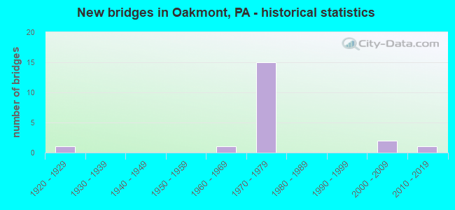
- New bridges - historical statistics
- 11920-1929
- 11960-1969
- 151970-1979
- 22000-2009
- 12010-2019

- Reconstructed bridges - Historical Statistics
- 11990-1999
- 82000-2009


- Bridge Condition - Deck
- 9.1%Very good
- 27.3%Good
- 45.5%Satisfactory
- 18.2%Fair

- Bridge Condition - Superstructure
- 9.1%Very good
- 9.1%Good
- 45.5%Satisfactory
- 36.4%Fair

- Bridge Condition - Substructure
- 9.1%Very good
- 27.3%Good
- 63.6%Satisfactory

- Bridge Condition - Channel
- 16.7%Very good
- 33.3%Good
- 33.3%Satisfactory
- 16.7%Fair
Find on map >> Show street view
Structure Number: 63, Location: 2.3 MI NE OF GAMMA DR (Lat: 40.533333, Lng: -79.841667), Route carried "on" structure: State highway 28, Year Built: 1971, Year Reconstructed: 2008, Status: Open, Structure Length: 4.36m (14.30ft), Average Daily Traffic: 19,394 (year 2020), Truck Traffic: 12%, Average Future Daily Traffic: 21,180 (year 2032), Design Load: HS 20, Features Intersected: GUYS RUN ROAD (SR 1011), Facility Carried by Structure: ALLEGHENY VAL EXPY
Minimum Vertical Clearance: 30+ m (98+ ft), Kilometerpoint: 18.137, Lanes on structure: 2, Lanes under structure: 2, Base Highway Network: Yes, Owner: State Highway Agency, Approaching Roadway Width: 11.9m (39.0ft), Skew: 11 degrees, Material/Design: Prestressed concrete, Design/Construction: Box Beam or Girders - Single/Spread, Number Of Spans In Main Unit: 3, Length of Maximum Span: 16.8m (55.1ft), Curb or Sidewalk Widths: Left: 0.2m (0.7ft), Right: 0.2m (0.7ft), Curb-To-Curb Width: 12.5m (41.0ft), Out-to-Out Width: 13.3m (43.6ft)
Condition: Deck: Satisfactory, Superstructure: Fair, Substructure: Satisfactory, Operating Rating: 75.3 metric tons, Method Used To Determine Operating Rating: Load Factor (LF), Inventory Rating: 36.3 metric tons, Method Used To Determine Inventory Rating: Load Factor (LF), Structural Evaluation: Somewhat better than minimum adequacy, Deck Geometry: Better than present minimum criteria, Underclear: Somewhat better than minimum adequacy, Approach Roadway Alignment: Equal to present desirable criteria, Length Of Structure Improvement: 4.40m (14.44ft), Designated Inspection Frequency: Every 24 months, Inspection Date: April 2020, Bridge Improvement Cost: $45,000, Roadway Improvement Cost: $131,000, Total Project Cost: $602,000, Deck Structure Type: Concrete Cast-file-Place, Wearing Surface/Protective System: Wearing Surface: Latex Concrete, Deck Protection: Epoxy Coated Reinforcing
Find on map >> Show street view
Structure Number: 631, Location: BARGE BASIN (Lat: 40.533156, Lng: -79.847631), Route carried "on" structure: State highway 28, Year Built: 1971, Year Reconstructed: 2004, Status: Open, Structure Length: 30.24m (99.21ft), Average Daily Traffic: 19,576 (year 2020), Truck Traffic: 13%, Average Future Daily Traffic: 20,362 (year 2032), Design Load: HS 20, Features Intersected: COAL CO RD & BARGE BASIN
Minimum Vertical Clearance: 30+ m (98+ ft), Kilometerpoint: 18.303, Lanes on structure: 2, Lanes under structure: 4, Base Highway Network: Yes, Owner: State Highway Agency, Approaching Roadway Width: 12.2m (40.0ft), Skew: 19 degrees, Material/Design: Steel continuous, Design/Construction: Girder and Floorbeam System, Number Of Spans In Main Unit: 3, Number Of Approach Spans: 3, Length of Maximum Span: 93.3m (306.1ft), Curb or Sidewalk Widths: Left: 0.2m (0.7ft), Right: 0.2m (0.7ft), Curb-To-Curb Width: 9.0m (29.5ft), Out-to-Out Width: 10.2m (33.5ft)
Condition: Deck: Satisfactory, Superstructure: Satisfactory, Substructure: Satisfactory, Channel: Good, Operating Rating: 48.1 metric tons, Method Used To Determine Operating Rating: Load Factor (LF), Inventory Rating: 29.0 metric tons, Method Used To Determine Inventory Rating: Load Factor (LF), Structural Evaluation: Equal to present minimum criteria, Deck Geometry: Meets minimum limits, Underclear: High priority of corrective action, Waterway Adequacy: Superior to present desirable criteria, Approach Roadway Alignment: Equal to present desirable criteria, Length Of Structure Improvement: 30.50m (100.07ft), Designated Inspection Frequency: Every 24 months, Critical Feature Inspection Frequency: Every 24 months, Underwater Inspection Frequency: Every 60 months, Inspection Date: April 2020, Critical Feature Inspection Date: April 2020, Underwater Inspection Date: August 2021, Bridge Improvement Cost: $126,000, Roadway Improvement Cost: $371,000, Total Project Cost: $1,700,000, Deck Structure Type: Concrete Cast-file-Place, Wearing Surface/Protective System: Wearing Surface: Latex Concrete, Deck Protection: Epoxy Coated Reinforcing
Find on map >> Show street view
Structure Number: 632, Location: 0.7 MI SW OF SR 0910 (Lat: 40.534786, Lng: -79.845914), Route carried "on" structure: State highway 28, Year Built: 1971, Year Reconstructed: 2008, Status: Open, Structure Length: 4.36m (14.30ft), Average Daily Traffic: 19,576 (year 2020), Truck Traffic: 13%, Average Future Daily Traffic: 20,362 (year 2032), Design Load: HS 20, Features Intersected: GUYS RUN ROAD (SR 1011), Facility Carried by Structure: ALLEGHENY VAL EXPY
Minimum Vertical Clearance: 30+ m (98+ ft), Kilometerpoint: 18.303, Lanes on structure: 2, Lanes under structure: 2, Base Highway Network: Yes, Owner: State Highway Agency, Approaching Roadway Width: 11.9m (39.0ft), Skew: 11 degrees, Material/Design: Prestressed concrete, Design/Construction: Box Beam or Girders - Single/Spread, Number Of Spans In Main Unit: 3, Length of Maximum Span: 16.8m (55.1ft), Curb or Sidewalk Widths: Left: 0.2m (0.7ft), Right: 0.2m (0.7ft), Curb-To-Curb Width: 12.5m (41.0ft), Out-to-Out Width: 13.3m (43.6ft)
Condition: Deck: Satisfactory, Superstructure: Satisfactory, Substructure: Good, Operating Rating: 76.2 metric tons, Method Used To Determine Operating Rating: Load Factor (LF), Inventory Rating: 45.4 metric tons, Method Used To Determine Inventory Rating: Load Factor (LF), Structural Evaluation: Equal to present minimum criteria, Deck Geometry: Better than present minimum criteria, Underclear: Somewhat better than minimum adequacy, Approach Roadway Alignment: Equal to present desirable criteria, Length Of Structure Improvement: 4.40m (14.44ft), Designated Inspection Frequency: Every 24 months, Inspection Date: April 2020, Bridge Improvement Cost: $45,000, Roadway Improvement Cost: $131,000, Total Project Cost: $602,000, Deck Structure Type: Concrete Cast-file-Place, Wearing Surface/Protective System: Wearing Surface: Latex Concrete
Find on map >> Show street view
Structure Number: 633, Location: NEAR HARMARVILLE INT. (Lat: 40.537919, Lng: -79.842739), Route carried "on" structure: State highway 28, Year Built: 1972, Year Reconstructed: 2008, Status: Open, Structure Length: 5.36m (17.59ft), Average Daily Traffic: 19,394 (year 2020), Truck Traffic: 12%, Average Future Daily Traffic: 21,180 (year 2032), Design Load: HS 20, Features Intersected: DEER CREEK
Minimum Vertical Clearance: 30+ m (98+ ft), Kilometerpoint: 19.216, Lanes on structure: 3, Base Highway Network: Yes, Owner: State Highway Agency, Approaching Roadway Width: 13.4m (44.0ft), Skew: 11 degrees, Material/Design: Prestressed concrete, Design/Construction: Box Beam or Girders - Single/Spread, Number Of Spans In Main Unit: 3, Length of Maximum Span: 22.9m (75.1ft), Curb or Sidewalk Widths: Left: 0.2m (0.7ft), Right: 0.2m (0.7ft), Curb-To-Curb Width: 14.6m (47.9ft), Out-to-Out Width: 15.4m (50.5ft)
Condition: Deck: Fair, Superstructure: Fair, Substructure: Satisfactory, Channel: Good, Operating Rating: 59.9 metric tons, Method Used To Determine Operating Rating: Load Factor (LF), Inventory Rating: 28.1 metric tons, Method Used To Determine Inventory Rating: Load Factor (LF), Structural Evaluation: Somewhat better than minimum adequacy, Deck Geometry: Meets minimum limits, Waterway Adequacy: Superior to present desirable criteria, Approach Roadway Alignment: Equal to present desirable criteria, Length Of Structure Improvement: 5.40m (17.72ft), Designated Inspection Frequency: Every 24 months, Inspection Date: April 2020, Bridge Improvement Cost: $48,000, Roadway Improvement Cost: $141,000, Total Project Cost: $648,000, Deck Structure Type: Concrete Cast-file-Place, Wearing Surface/Protective System: Wearing Surface: Latex Concrete, Deck Protection: Epoxy Coated Reinforcing
Find on map >> Show street view
Structure Number: 634, Location: HARMARVILLE INTERCHANGE (Lat: 40.540311, Lng: -79.840739), Route carried "on" structure: State highway 28, Year Built: 1970, Year Reconstructed: 2008, Status: Open, Structure Length: 5.79m (19.00ft), Average Daily Traffic: 19,866 (year 2022), Truck Traffic: 7%, Average Future Daily Traffic: 14,932 (year 2032), Design Load: HS 20, Features Intersected: LR 679-SR 910
Minimum Vertical Clearance: 30+ m (98+ ft), Kilometerpoint: 19.216, Lanes on structure: 2, Lanes under structure: 8, Base Highway Network: Yes, Owner: State Highway Agency, Approaching Roadway Width: 13.4m (44.0ft), Skew: 14 degrees, Material/Design: Steel, Design/Construction: Stringer/Multi-beam, Number Of Spans In Main Unit: 1, Number Of Approach Spans: 2, Length of Maximum Span: 33.5m (109.9ft), Curb or Sidewalk Widths: Left: 0.2m (0.7ft), Right: 0.2m (0.7ft), Curb-To-Curb Width: 12.0m (39.4ft), Out-to-Out Width: 13.2m (43.3ft)
Condition: Deck: Satisfactory, Superstructure: Satisfactory, Substructure: Satisfactory, Operating Rating: 59.0 metric tons, Method Used To Determine Operating Rating: Load Factor (LF), Inventory Rating: 35.4 metric tons, Method Used To Determine Inventory Rating: Load Factor (LF), Structural Evaluation: Equal to present minimum criteria, Deck Geometry: Equal to present minimum criteria, Underclear: Equal to present minimum criteria, Approach Roadway Alignment: Equal to present desirable criteria, Length Of Structure Improvement: 6.80m (22.31ft), Designated Inspection Frequency: Every 24 months, Inspection Date: April 2020, Deck Structure Type: Concrete Cast-file-Place, Wearing Surface/Protective System: Wearing Surface: Latex Concrete, Deck Protection: Epoxy Coated Reinforcing
Find on map >> Show street view
Structure Number: 635, Location: NEAR HARMARVILLE INTERCH (Lat: 40.538100, Lng: -79.842875), Route carried "on" structure: State highway 28, Year Built: 1970, Year Reconstructed: 2008, Status: Open, Structure Length: 5.36m (17.59ft), Average Daily Traffic: 19,576 (year 2020), Truck Traffic: 13%, Average Future Daily Traffic: 20,362 (year 2032), Design Load: HS 20, Features Intersected: DEER CREEK
Minimum Vertical Clearance: 30+ m (98+ ft), Kilometerpoint: 19.180, Lanes on structure: 2, Base Highway Network: Yes, Owner: State Highway Agency, Approaching Roadway Width: 12.8m (42.0ft), Skew: 13 degrees, Material/Design: Prestressed concrete, Design/Construction: Box Beam or Girders - Single/Spread, Number Of Spans In Main Unit: 3, Length of Maximum Span: 22.9m (75.1ft), Curb or Sidewalk Widths: Left: 0.2m (0.7ft), Right: 0.2m (0.7ft), Curb-To-Curb Width: 11.9m (39.0ft), Out-to-Out Width: 13.2m (43.3ft)
Condition: Deck: Satisfactory, Superstructure: Fair, Substructure: Satisfactory, Channel: Satisfactory, Operating Rating: 50.8 metric tons, Method Used To Determine Operating Rating: Load Factor (LF), Inventory Rating: 29.0 metric tons, Method Used To Determine Inventory Rating: Load Factor (LF), Structural Evaluation: Somewhat better than minimum adequacy, Deck Geometry: Equal to present minimum criteria, Waterway Adequacy: Superior to present desirable criteria, Approach Roadway Alignment: Equal to present desirable criteria, Length Of Structure Improvement: 6.30m (20.67ft), Designated Inspection Frequency: Every 24 months, Inspection Date: April 2020, Bridge Improvement Cost: $96,000, Roadway Improvement Cost: $281,000, Total Project Cost: $1,290,000, Deck Structure Type: Concrete Cast-file-Place, Wearing Surface/Protective System: Wearing Surface: Latex Concrete, Deck Protection: Epoxy Coated Reinforcing
Find on map >> Show street view
Structure Number: 636, Location: HARMARVILLE INTERCHANGE (Lat: 40.540636, Lng: -79.840739), Route carried "on" structure: State highway 28, Year Built: 1970, Year Reconstructed: 2008, Status: Open, Structure Length: 5.79m (19.00ft), Average Daily Traffic: 19,576 (year 2020), Truck Traffic: 13%, Average Future Daily Traffic: 20,362 (year 2032), Design Load: HS 20, Features Intersected: RT 0910 EB WB
Minimum Vertical Clearance: 30+ m (98+ ft), Kilometerpoint: 19.180, Lanes on structure: 2, Lanes under structure: 8, Base Highway Network: Yes, Owner: State Highway Agency, Approaching Roadway Width: 14.9m (48.9ft), Skew: 14 degrees, Material/Design: Steel, Design/Construction: Stringer/Multi-beam, Number Of Spans In Main Unit: 1, Number Of Approach Spans: 2, Length of Maximum Span: 33.2m (108.9ft), Curb or Sidewalk Widths: Left: 0.2m (0.7ft), Right: 0.2m (0.7ft), Curb-To-Curb Width: 12.0m (39.4ft), Out-to-Out Width: 13.2m (43.3ft)
Condition: Deck: Fair, Superstructure: Satisfactory, Substructure: Satisfactory, Operating Rating: 59.9 metric tons, Method Used To Determine Operating Rating: Load Factor (LF), Inventory Rating: 35.4 metric tons, Method Used To Determine Inventory Rating: Load Factor (LF), Structural Evaluation: Equal to present minimum criteria, Deck Geometry: Equal to present minimum criteria, Underclear: Meets minimum limits, Approach Roadway Alignment: Equal to present desirable criteria, Length Of Structure Improvement: 6.80m (22.31ft), Designated Inspection Frequency: Every 24 months, Inspection Date: April 2020, Bridge Improvement Cost: $33,000, Roadway Improvement Cost: $96,000, Total Project Cost: $442,000, Deck Structure Type: Concrete Cast-file-Place, Wearing Surface/Protective System: Wearing Surface: Latex Concrete
Find on map >> Show street view
Structure Number: 1366, Location: HARMAR OVER BARGE BASIN (Lat: 40.531853, Lng: -79.847950), Route carried "on" structure: State highway , Year Built: 1928, Year Reconstructed: 2012, Status: Open, Structure Length: 2.59m (8.50ft), Average Daily Traffic: 18,784 (year 2020), Truck Traffic: 9%, Average Future Daily Traffic: 13,577 (year 2032), Design Load: HS 20, Features Intersected: BARGE BASIN, Facility Carried by Structure: FREEPORT RD
Minimum Vertical Clearance: 30+ m (98+ ft), Kilometerpoint: 12.460, Lanes on structure: 3, Base Highway Network: Yes, Owner: State Highway Agency, Approaching Roadway Width: 12.2m (40.0ft), Skew: 1 degrees, Navigation Control: Yes ( Vertical Clearance: 712.0m (2,336.0ft), Horizontal Clearance: 275.6m (904.2ft)), Material/Design: Steel, Design/Construction: Girder and Floorbeam System, Number Of Spans In Main Unit: 1, Length of Maximum Span: 25.3m (83.0ft), Curb or Sidewalk Widths: Left: 2.0m (6.6ft), Right: 0.0m, Curb-To-Curb Width: 11.6m (38.1ft), Out-to-Out Width: 11.6m (38.1ft)
Condition: Deck: Good, Superstructure: Satisfactory, Substructure: Satisfactory, Channel: Very good, Operating Rating: 70.8 metric tons, Method Used To Determine Operating Rating: Load Factor (LF), Inventory Rating: 41.7 metric tons, Method Used To Determine Inventory Rating: Load Factor (LF), Structural Evaluation: Equal to present minimum criteria, Deck Geometry: High priority of replacement, Waterway Adequacy: Superior to present desirable criteria, Approach Roadway Alignment: Equal to present desirable criteria, Length Of Structure Improvement: 2.60m (8.53ft), Designated Inspection Frequency: Every 24 months, Critical Feature Inspection Frequency: Every 24 months, Inspection Date: September 2021, Critical Feature Inspection Date: September 2021, Bridge Improvement Cost: $44,000, Roadway Improvement Cost: $129,000, Total Project Cost: $593,000, Deck Structure Type: Concrete Cast-file-Place, Wearing Surface/Protective System: Wearing Surface: Integral Concrete, Deck Protection: Epoxy Coated Reinforcing
Find on map >> Show street view
Structure Number: 1631, Location: OAKMONT VERONA LINE (Lat: 40.511850, Lng: -79.834978), Route carried "on" structure: State highway , Year Built: 1966, Year Reconstructed: 2013, Status: Open, Structure Length: 4.33m (14.21ft), Average Daily Traffic: 3,027 (year 2020), Truck Traffic: 5%, Average Future Daily Traffic: 3,198 (year 2032), Design Load: HS 20, Features Intersected: PLUM CREEK, Facility Carried by Structure: PLUM AVE
Minimum Vertical Clearance: 30+ m (98+ ft), Kilometerpoint: 0.600, Lanes on structure: 2, Owner: State Highway Agency, Approaching Roadway Width: 7.3m (24.0ft), Skew: 4 degrees, Material/Design: Steel, Design/Construction: Stringer/Multi-beam, Number Of Spans In Main Unit: 3, Length of Maximum Span: 14.3m (46.9ft), Curb or Sidewalk Widths: Left: 1.5m (4.9ft), Right: 0.5m (1.6ft), Curb-To-Curb Width: 8.5m (27.9ft), Out-to-Out Width: 11.6m (38.1ft)
Condition: Deck: Very good, Superstructure: Fair, Substructure: Good, Channel: Fair, Operating Rating: 59.0 metric tons, Method Used To Determine Operating Rating: Load Factor (LF), Inventory Rating: 35.4 metric tons, Method Used To Determine Inventory Rating: Load Factor (LF), Structural Evaluation: Somewhat better than minimum adequacy, Deck Geometry: Meets minimum limits, Waterway Adequacy: Superior to present desirable criteria, Approach Roadway Alignment: Equal to present desirable criteria, Length Of Structure Improvement: 5.80m (19.03ft), Designated Inspection Frequency: Every 24 months, Inspection Date: March 2020, Bridge Improvement Cost: $49,000, Roadway Improvement Cost: $143,000, Total Project Cost: $656,000, Deck Structure Type: Concrete Cast-file-Place, Wearing Surface/Protective System: Wearing Surface: Monolithic Concrete
Find on map >> Show street view
Structure Number: 44171, Location: Beside Oakmont Golf Club (Lat: 40.525722, Lng: -79.822622), Route carried "on" structure: State highway , Year Built: 2007, Status: Open, Structure Length: 7.68m (25.20ft), Average Daily Traffic: 11,870 (year 2021), Truck Traffic: 10%, Average Future Daily Traffic: 17,808 (year 2032), Design Load: HS 20, Features Intersected: Turnpike, B&LE RR, Facility Carried by Structure: Hulton Rd
Minimum Vertical Clearance: 30+ m (98+ ft), Kilometerpoint: 2.533, Lanes on structure: 2, Lanes under structure: 6, Owner: State Highway Agency, Approaching Roadway Width: 14.6m (47.9ft), Material/Design: Steel continuous, Design/Construction: Stringer/Multi-beam, Number Of Spans In Main Unit: 2, Length of Maximum Span: 40.8m (133.9ft), Curb or Sidewalk Widths: Left: 0.2m (0.7ft), Right: 0.2m (0.7ft), Curb-To-Curb Width: 14.6m (47.9ft), Out-to-Out Width: 15.7m (51.5ft)
Condition: Deck: Good, Superstructure: Good, Substructure: Good, Operating Rating: 66.2 metric tons, Method Used To Determine Operating Rating: Load Factor (LF), Inventory Rating: 39.0 metric tons, Method Used To Determine Inventory Rating: Load Factor (LF), Structural Evaluation: Better than present minimum criteria, Deck Geometry: Superior to present desirable criteria, Underclear: High priority of corrective action, Approach Roadway Alignment: Better than present minimum criteria, Designated Inspection Frequency: Every 24 months, Inspection Date: November 2019, Deck Structure Type: Concrete Cast-file-Place, Wearing Surface/Protective System: Wearing Surface: Monolithic Concrete, Deck Protection: Epoxy Coated Reinforcing
Find on map >> Show street view
Structure Number: 52488, Location: Hulton Bridge (Lat: 40.527628, Lng: -79.847828), Route carried "on" structure: State highway , Year Built: 2015, Status: Open, Structure Length: 49.77m (163.29ft), Average Daily Traffic: 18,480 (year 2022), Truck Traffic: 7%, Average Future Daily Traffic: 23,000 (year 2032), Design Load: HL 93, Features Intersected: N&S RR, ALLEGHENY RIVER, Facility Carried by Structure: Hulton Bridge
Minimum Vertical Clearance: 5.79m (19.00ft), Kilometerpoint: 0.000, Lanes on structure: 4, Base Highway Network: Yes, Owner: State Highway Agency, Approaching Roadway Width: 17.1m (56.1ft), Skew: 1 degrees, Material/Design: Steel continuous, Design/Construction: Stringer/Multi-beam, Number Of Spans In Main Unit: 4, Number Of Approach Spans: 1, Length of Maximum Span: 152.4m (500.0ft), Curb or Sidewalk Widths: Left: 0.0m, Right: 1.5m (4.9ft), Curb-To-Curb Width: 17.1m (56.1ft), Out-to-Out Width: 21.1m (69.2ft)
Condition: Deck: Good, Superstructure: Very good, Substructure: Very good, Channel: Satisfactory, Operating Rating: 48.0 metric tons, Method Used To Determine Operating Rating: Assigned ratings based on Load and Resistance Factor Design (LRFD) reported by rating factor (RF) using HL93 loadings, Inventory Rating: 36.6 metric tons, Method Used To Determine Inventory Rating: Assigned ratings based on Load and Resistance Factor Design (LRFD) reported by rating factor (RF) using HL93 loadings, Structural Evaluation: Equal to present desirable criteria, Deck Geometry: Somewhat better than minimum adequacy, Underclear: High priority of corrective action, Waterway Adequacy: Superior to present desirable criteria, Approach Roadway Alignment: Equal to present desirable criteria, Designated Inspection Frequency: Every 24 months, Underwater Inspection Frequency: Every 60 months, Inspection Date: August 2021, Underwater Inspection Date: April 2021, Deck Structure Type: Concrete Cast-file-Place, Wearing Surface/Protective System: Wearing Surface: Monolithic Concrete, Deck Protection: Epoxy Coated Reinforcing
Find on map >> Show street view
Structure Number: 63, Location: 2.3 MI NE OF GAMMA DR (Lat: 40.533333, Lng: -79.841667), Route carried "under" structure: State highway , Year Built: 1971, Structure Length: 0. m, Average Daily Traffic: 3,223 (year 2020), Truck Traffic: 10%, Features Intersected: GUYS RUN ROAD (SR 1011), Facility Carried by Structure: ALLEGHENY VAL EXPY
Minimum Vertical Clearance: 7.03m (23.06ft), Kilometerpoint: 0.000, Lanes on structure: 2, Lanes under structure: 2, Material/Design: Prestressed concrete, Design/Construction: Box Beam or Girders - Single/Spread, Length of Maximum Span: 16.8m (55.1ft)
Find on map >> Show street view
Structure Number: 631, Location: BARGE BASIN (Lat: 40.533156, Lng: -79.847631), Route carried "under" structure: ServiceOther road , Year Built: 1971, Structure Length: 0. m, Average Daily Traffic: 1 (year 2006), Truck Traffic: 1%, Features Intersected: COAL CO RD & BARGE BASIN, Facility Carried by Structure: SR 0028 SB
Minimum Vertical Clearance: 10.46m (34.32ft), Kilometerpoint: 0.000, Lanes on structure: 2, Lanes under structure: 2, Material/Design: Steel continuous, Design/Construction: Girder and Floorbeam System, Length of Maximum Span: 93.3m (306.1ft)
Find on map >> Show street view
Structure Number: 631, Location: BARGE BASIN (Lat: 40.533156, Lng: -79.847631), Route carried "under" structure: ServiceOther road , Year Built: 1971, Structure Length: 0. m, Average Daily Traffic: 10 (year 2006), Truck Traffic: 1%, Features Intersected: COAL CO RD & BARGE BASIN, Facility Carried by Structure: SR 0028 SB
Minimum Vertical Clearance: 6.45m (21.16ft), Kilometerpoint: 0.000, Lanes on structure: 2, Lanes under structure: 2, Material/Design: Steel continuous, Design/Construction: Girder and Floorbeam System, Length of Maximum Span: 93.3m (306.1ft)
Find on map >> Show street view
Structure Number: 632, Location: 0.7 MI SW OF SR 0910 (Lat: 40.534786, Lng: -79.845914), Route carried "under" structure: State highway , Year Built: 1971, Structure Length: 0. m, Average Daily Traffic: 3,223 (year 2020), Truck Traffic: 10%, Features Intersected: GUYS RUN ROAD (SR 1011), Facility Carried by Structure: ALLEGHENY VAL EXPY
Minimum Vertical Clearance: 7.21m (23.65ft), Kilometerpoint: 0.000, Lanes on structure: 2, Lanes under structure: 2, Material/Design: Prestressed concrete, Design/Construction: Box Beam or Girders - Single/Spread, Length of Maximum Span: 16.8m (55.1ft)
Find on map >> Show street view
Structure Number: 634, Location: HARMARVILLE INTERCHANGE (Lat: 40.540311, Lng: -79.840739), Route carried "under" structure: State highway 910, Year Built: 1970, Structure Length: 0. m, Average Daily Traffic: 7,518 (year 2022), Truck Traffic: 5%, Features Intersected: LR 679-SR 910, Facility Carried by Structure: SR 0028 NB
Minimum Vertical Clearance: 5.28m (17.32ft), Kilometerpoint: 30.555, Lanes on structure: 2, Lanes under structure: 4, Material/Design: Steel, Design/Construction: Stringer/Multi-beam, Length of Maximum Span: 33.5m (109.9ft)
Find on map >> Show street view
Structure Number: 634, Location: HARMARVILLE INTERCHANGE (Lat: 40.540311, Lng: -79.840739), Route carried "under" structure: State highway 910, Year Built: 1970, Structure Length: 0. m, Average Daily Traffic: 5,662 (year 2022), Truck Traffic: 8%, Features Intersected: LR 679-SR 910, Facility Carried by Structure: SR 0028 NB
Minimum Vertical Clearance: 4.75m (15.58ft), Kilometerpoint: 30.550, Lanes on structure: 2, Lanes under structure: 4, Material/Design: Steel, Design/Construction: Stringer/Multi-beam, Length of Maximum Span: 33.5m (109.9ft)
Find on map >> Show street view
Structure Number: 636, Location: HARMARVILLE INTERCHANGE (Lat: 40.540636, Lng: -79.840739), Route carried "under" structure: State highway 910, Year Built: 1970, Structure Length: 0. m, Average Daily Traffic: 7,518 (year 2022), Truck Traffic: 5%, Features Intersected: RT 0910 EB WB, Facility Carried by Structure: SR 0028 SB
Minimum Vertical Clearance: 5.77m (18.93ft), Kilometerpoint: 30.555, Lanes on structure: 2, Lanes under structure: 4, Material/Design: Steel, Design/Construction: Stringer/Multi-beam, Length of Maximum Span: 33.2m (108.9ft)
Find on map >> Show street view
Structure Number: 636, Location: HARMARVILLE INTERCHANGE (Lat: 40.540636, Lng: -79.840739), Route carried "under" structure: State highway 910, Year Built: 1970, Structure Length: 0. m, Average Daily Traffic: 5,662 (year 2022), Truck Traffic: 8%, Features Intersected: RT 0910 EB WB, Facility Carried by Structure: SR 0028 SB
Minimum Vertical Clearance: 5.26m (17.26ft), Kilometerpoint: 30.550, Lanes on structure: 2, Lanes under structure: 4, Material/Design: Steel, Design/Construction: Stringer/Multi-beam, Length of Maximum Span: 33.2m (108.9ft)
Find on map >> Show street view
Structure Number: 44171, Location: Beside Oakmont Golf Club (Lat: 40.525722, Lng: -79.822622), Route carried "under" structure: Interstate 76, Year Built: 2007, Structure Length: 0. m, Average Daily Traffic: 1 (year 2017), Features Intersected: Turnpike, B&LE RR, Facility Carried by Structure: Hulton Rd
Minimum Vertical Clearance: 5.28m (17.32ft), Kilometerpoint: 1.609, Lanes on structure: 2, Lanes under structure: 6, Toll: On toll road, Material/Design: Steel continuous, Design/Construction: Stringer/Multi-beam, Length of Maximum Span: 40.8m (133.9ft)