Bridge Statistics for Opelousas, Louisiana (LA)
Condition, Traffic, Stress, Structural Evaluation, Project Costs
- National Bridge Inventory (NBI) Statistics
- 100Number of bridges
- 1,198ft / 365mTotal length
- $4,782,000Total costs
- 715,036Total average daily traffic
- 112,559Total average daily truck traffic
- National Bridge Inventory (NBI) Registered Bridges for Opelousas
- No street view available for this location
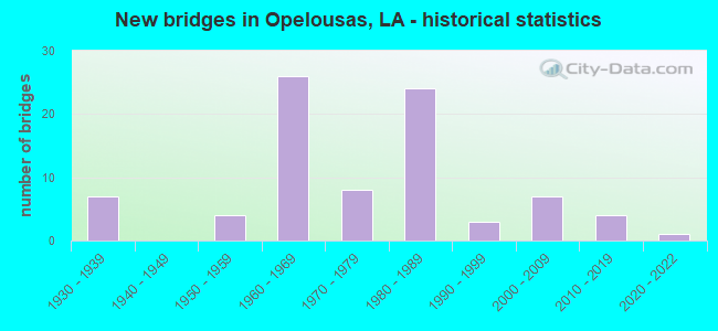
- New bridges - historical statistics
- 71930-1939
- 41950-1959
- 261960-1969
- 81970-1979
- 241980-1989
- 31990-1999
- 72000-2009
- 42010-2019
- 12020-2022


- Bridge Condition - Deck
- 6.1%Very good
- 40.8%Good
- 34.7%Satisfactory
- 16.3%Fair
- 2.0%Serious

- Bridge Condition - Superstructure
- 8.2%Very good
- 42.9%Good
- 32.7%Satisfactory
- 14.3%Fair
- 2.0%Poor

- Bridge Condition - Substructure
- 6.1%Very good
- 46.9%Good
- 28.6%Satisfactory
- 8.2%Fair
- 8.2%Poor
- 2.0%Imminent failure

- Bridge Condition - Channel
- 1.4%Excellent
- 37.5%Very good
- 45.8%Good
- 13.9%Satisfactory
- 1.4%Fair

- Bridge Condition - Culverts
- 8.6%Very good
- 42.9%Good
- 42.9%Satisfactory
- 5.7%Fair
Find on map >> Show street view
Structure Number: 34900000030421, Location: 1.4 MI W. OF US 190 (Lat: 30.538300, Lng: -92.129900), Route carried "on" structure: County highway 104, Year Built: 2013, Status: Open, Structure Length: 2.44m (8.01ft), Average Daily Traffic: 3,100 (year 2016), Truck Traffic: 13%, Average Future Daily Traffic: 4,160 (year 2036), Design Load: HS 20, Features Intersected: BAYOU PLAQUEMINE
Minimum Vertical Clearance: 30+ m (98+ ft), Kilometerpoint: 11.137, Lanes on structure: 2, Owner: State Highway Agency, Approaching Roadway Width: 6.1m (20.0ft), Skew: 30 degrees, Material/Design: Concrete, Design/Construction: Slab, Number Of Spans In Main Unit: 4, Length of Maximum Span: 6.1m (20.0ft), Curb-To-Curb Width: 9.1m (29.9ft), Out-to-Out Width: 10.1m (33.1ft)
Condition: Deck: Good, Superstructure: Good, Substructure: Very good, Channel: Very good, Operating Rating: 59.9 metric tons, Method Used To Determine Operating Rating: Load and Resistance Factor Rating (LRFR) rating reported by rating factor(RF) method using HL-93 loadings, Inventory Rating: 46.3 metric tons, Method Used To Determine Inventory Rating: Load and Resistance Factor Rating (LRFR) rating reported by rating factor(RF) method using HL-93 loadings, Structural Evaluation: Better than present minimum criteria, Deck Geometry: Meets minimum limits, Waterway Adequacy: Equal to present desirable criteria, Approach Roadway Alignment: Equal to present desirable criteria, Designated Inspection Frequency: Every 24 months, Inspection Date: August 2021, Deck Structure Type: Concrete Cast-file-Place, Wearing Surface/Protective System: Wearing Surface: Monolithic Concrete
Find on map >> Show street view
Structure Number: 34900000030441, Location: 0.39 Mi E of LA 357 (Lat: 30.526900, Lng: -92.094569), Route carried "on" structure: County highway , Year Built: 2011, Status: Open, Structure Length: 1.22m (4.00ft), Average Daily Traffic: 150 (year 2020), Average Future Daily Traffic: 165 (year 2040), Design Load: HS 20, Features Intersected: Yarbor Bayou, Facility Carried by Structure: Hiram St
Minimum Vertical Clearance: 30+ m (98+ ft), Kilometerpoint: 0.000, Lanes on structure: 2, Owner: City or Municipal Highway Agency, Approaching Roadway Width: 7.3m (24.0ft), Skew: 36 degrees, Material/Design: Concrete, Design/Construction: Slab, Number Of Spans In Main Unit: 2, Length of Maximum Span: 6.1m (20.0ft), Curb-To-Curb Width: 8.5m (27.9ft), Out-to-Out Width: 9.3m (30.5ft)
Condition: Deck: Very good, Superstructure: Very good, Substructure: Good, Channel: Very good, Operating Rating: 57.0 metric tons, Method Used To Determine Operating Rating: Load and Resistance Factor Rating (LRFR) rating reported by rating factor(RF) method using HL-93 loadings, Inventory Rating: 43.7 metric tons, Method Used To Determine Inventory Rating: Load and Resistance Factor Rating (LRFR) rating reported by rating factor(RF) method using HL-93 loadings, Structural Evaluation: Better than present minimum criteria, Deck Geometry: Equal to present minimum criteria, Waterway Adequacy: Equal to present desirable criteria, Approach Roadway Alignment: Equal to present desirable criteria, Designated Inspection Frequency: Every 24 months, Inspection Date: January 2021, Deck Structure Type: Concrete Precast Panels, Wearing Surface/Protective System: Wearing Surface: Monolithic Concrete
Find on map >> Show street view
Structure Number: 34900000034903, Location: .01 Mi West of I-49 (Lat: 30.499339, Lng: -92.073761), Route carried "on" structure: City street , Year Built: 2020, Status: Open, Structure Length: 1.34m (4.40ft), Average Daily Traffic: 5,500 (year 2019), Average Future Daily Traffic: 7,250 (year 2039), Design Load: HL 93, Features Intersected: Drainage Bayou, Facility Carried by Structure: Judson Walsh Drive
Minimum Vertical Clearance: 30+ m (98+ ft), Kilometerpoint: 1.402, Lanes on structure: 2, Owner: City or Municipal Highway Agency, Approaching Roadway Width: 7.6m (24.9ft), Skew: 1 degrees, Material/Design: Concrete, Design/Construction: Culvert, Number Of Spans In Main Unit: 4, Length of Maximum Span: 3.0m (9.8ft), Curb-To-Curb Width: 9.8m (32.2ft), Out-to-Out Width: 16.5m (54.1ft)
Condition: Channel: Good, Culverts: Good, Operating Rating: 42.1 metric tons, Method Used To Determine Operating Rating: Load and Resistance Factor Rating (LRFR) rating reported by rating factor(RF) method using HL-93 loadings, Inventory Rating: 32.4 metric tons, Method Used To Determine Inventory Rating: Load and Resistance Factor Rating (LRFR) rating reported by rating factor(RF) method using HL-93 loadings, Structural Evaluation: Better than present minimum criteria, Deck Geometry: Meets minimum limits, Waterway Adequacy: Better than present minimum criteria, Approach Roadway Alignment: Equal to present desirable criteria, Designated Inspection Frequency: Every 24 months, Inspection Date: January 2021
Find on map >> Show street view
Structure Number: 34900000800215, Location: 0.8Mi E of LA 357 (Lat: 30.513181, Lng: -92.095081), Route carried "on" structure: County highway , Year Built: 2015, Status: Open, Structure Length: 1.22m (4.00ft), Average Daily Traffic: 2,100 (year 2020), Average Future Daily Traffic: 2,310 (year 2040), Design Load: HL 93, Features Intersected: BAYOU YARBOR, Facility Carried by Structure: Maccarty Dr
Minimum Vertical Clearance: 30+ m (98+ ft), Kilometerpoint: 0.000, Lanes on structure: 2, Owner: City or Municipal Highway Agency, Approaching Roadway Width: 7.0m (23.0ft), Skew: 30 degrees, Material/Design: Concrete, Design/Construction: Slab, Number Of Spans In Main Unit: 2, Length of Maximum Span: 6.1m (20.0ft), Curb-To-Curb Width: 7.1m (23.3ft), Out-to-Out Width: 8.2m (26.9ft)
Condition: Deck: Very good, Superstructure: Very good, Substructure: Good, Channel: Excellent, Operating Rating: 51.5 metric tons, Method Used To Determine Operating Rating: Load and Resistance Factor Rating (LRFR) rating reported by rating factor(RF) method using HL-93 loadings, Inventory Rating: 39.9 metric tons, Method Used To Determine Inventory Rating: Load and Resistance Factor Rating (LRFR) rating reported by rating factor(RF) method using HL-93 loadings, Structural Evaluation: Better than present minimum criteria, Deck Geometry: High priority of replacement, Waterway Adequacy: Better than present minimum criteria, Approach Roadway Alignment: Equal to present minimum criteria, Designated Inspection Frequency: Every 24 months, Inspection Date: January 2021, Deck Structure Type: Concrete Precast Panels, Wearing Surface/Protective System: Wearing Surface: Monolithic Concrete
Find on map >> Show street view
Structure Number: 34900000800318, Location: 1.2 Mi N of LA 31 (Lat: 30.495219, Lng: -92.030431), Route carried "on" structure: County highway , Year Built: 2011, Status: Open, Structure Length: 4.88m (16.01ft), Average Daily Traffic: 50 (year 2020), Average Future Daily Traffic: 55 (year 2040), Design Load: HS 20, Features Intersected: COULEE ROUGE, Facility Carried by Structure: Little Teche Rd
Minimum Vertical Clearance: 30+ m (98+ ft), Kilometerpoint: 0.000, Lanes on structure: 2, Owner: County Highway Agency, Approaching Roadway Width: 5.2m (17.1ft), Skew: 30 degrees, Material/Design: Prestressed concrete, Design/Construction: Box Beam or Girders - Multiple, Number Of Spans In Main Unit: 4, Length of Maximum Span: 12.2m (40.0ft), Curb-To-Curb Width: 7.3m (24.0ft), Out-to-Out Width: 8.1m (26.6ft)
Condition: Deck: Very good, Superstructure: Very good, Substructure: Good, Channel: Very good, Operating Rating: 55.1 metric tons, Method Used To Determine Operating Rating: Load and Resistance Factor Rating (LRFR) rating reported by rating factor(RF) method using HL-93 loadings, Inventory Rating: 36.0 metric tons, Method Used To Determine Inventory Rating: Load and Resistance Factor Rating (LRFR) rating reported by rating factor(RF) method using HL-93 loadings, Structural Evaluation: Better than present minimum criteria, Deck Geometry: Equal to present minimum criteria, Waterway Adequacy: Equal to present desirable criteria, Approach Roadway Alignment: Better than present minimum criteria, Designated Inspection Frequency: Every 24 months, Inspection Date: April 2021, Deck Structure Type: Concrete Cast-file-Place, Wearing Surface/Protective System: Wearing Surface: Monolithic Concrete
Find on map >> Show street view
Structure Number: 34900121203501, Location: 3.5 MI EAST OF LA 35 (Lat: 30.532081, Lng: -92.130700), Route carried "on" structure: US 190, Year Built: 1931, Status: Open, Structure Length: 1.10m (3.61ft), Average Daily Traffic: 9,300 (year 2016), Truck Traffic: 10%, Average Future Daily Traffic: 12,090 (year 2036), Design Load: H 15, Features Intersected: BAYOU PLAQUEMINE
Minimum Vertical Clearance: 30+ m (98+ ft), Kilometerpoint: 5.628, Lanes on structure: 4, Base Highway Network: Yes (Inventory Route: 12-12-1, Subroute: 10), Owner: State Highway Agency, Approaching Roadway Width: 11.6m (38.1ft), Skew: 12 degrees, Material/Design: Concrete, Design/Construction: Culvert, Number Of Spans In Main Unit: 4, Length of Maximum Span: 2.4m (7.9ft), Curb-To-Curb Width: 23.2m (76.1ft), Out-to-Out Width: 30.6m (100.4ft)
Condition: Channel: Satisfactory, Culverts: Fair, Operating Rating: 42.1 metric tons, Method Used To Determine Operating Rating: Load and Resistance Factor Rating (LRFR) rating reported by rating factor(RF) method using HL-93 loadings, Inventory Rating: 32.4 metric tons, Method Used To Determine Inventory Rating: Load and Resistance Factor Rating (LRFR) rating reported by rating factor(RF) method using HL-93 loadings, Structural Evaluation: Somewhat better than minimum adequacy, Deck Geometry: Superior to present desirable criteria, Waterway Adequacy: Equal to present minimum criteria, Approach Roadway Alignment: Equal to present desirable criteria, Designated Inspection Frequency: Every 24 months, Inspection Date: Febuary 2021, Deck Structure Type: Concrete Cast-file-Place
Find on map >> Show street view
Structure Number: 34900121206281, Location: 0.2 MI EAST OF LA 749 (Lat: 30.532319, Lng: -92.085600), Route carried "on" structure: US 190, Year Built: 1931, Status: Open, Structure Length: 0.67m (2.20ft), Average Daily Traffic: 13,350 (year 2016), Truck Traffic: 10%, Average Future Daily Traffic: 20,436 (year 2036), Design Load: HS 20, Features Intersected: BAYOU CALAHAN
Minimum Vertical Clearance: 30+ m (98+ ft), Kilometerpoint: 10.033, Lanes on structure: 2, Base Highway Network: Yes (Inventory Route: 12-12-1, Subroute: 10), Owner: State Highway Agency, Approaching Roadway Width: 8.5m (27.9ft), Skew: 12 degrees, Material/Design: Concrete, Design/Construction: Culvert, Number Of Spans In Main Unit: 2, Length of Maximum Span: 3.0m (9.8ft), Curb or Sidewalk Widths: Left: 2.4m (7.9ft), Right: 2.4m (7.9ft), Curb-To-Curb Width: 7.6m (24.9ft), Out-to-Out Width: 13.0m (42.7ft)
Condition: Channel: Very good, Culverts: Satisfactory, Operating Rating: 32.4 metric tons, Method Used To Determine Operating Rating: Assigned ratings based on Load and Resistance Factor Design (LRFD) reported by rating factor (RF) using HL93 loadings, Inventory Rating: 24.9 metric tons, Method Used To Determine Inventory Rating: Assigned ratings based on Load and Resistance Factor Design (LRFD) reported by rating factor (RF) using HL93 loadings, Structural Evaluation: Equal to present minimum criteria, Deck Geometry: High priority of replacement, Waterway Adequacy: Equal to present desirable criteria, Approach Roadway Alignment: Equal to present desirable criteria, Length Of Structure Improvement: 1.28m (4.20ft), Designated Inspection Frequency: Every 24 months, Inspection Date: Febuary 2021, Bridge Improvement Cost: $109,000, Total Project Cost: $163,000 ( Estimate for 2016), Deck Structure Type: Concrete Cast-file-Place
Find on map >> Show street view
Structure Number: 34900121206282, Location: 0.2 MI EAST OF LA 749 (Lat: 30.533350, Lng: -92.085100), Route carried "on" structure: US 190, Year Built: 1967, Status: Open, Structure Length: 0.67m (2.20ft), Average Daily Traffic: 13,350 (year 2016), Truck Traffic: 10%, Average Future Daily Traffic: 20,436 (year 2036), Design Load: H 15, Features Intersected: BAYOU CALAHAN
Minimum Vertical Clearance: 30+ m (98+ ft), Kilometerpoint: 0.398, Lanes on structure: 2, Base Highway Network: Yes (Inventory Route: 12-12-2, Subroute: 10), Owner: State Highway Agency, Approaching Roadway Width: 10.7m (35.1ft), Skew: 10 degrees, Material/Design: Concrete, Design/Construction: Culvert, Number Of Spans In Main Unit: 2, Length of Maximum Span: 3.0m (9.8ft), Curb or Sidewalk Widths: Left: 2.5m (8.2ft), Right: 2.3m (7.5ft), Curb-To-Curb Width: 10.6m (34.8ft), Out-to-Out Width: 16.6m (54.5ft)
Condition: Channel: Very good, Culverts: Satisfactory, Operating Rating: 42.1 metric tons, Method Used To Determine Operating Rating: Load and Resistance Factor Rating (LRFR) rating reported by rating factor(RF) method using HL-93 loadings, Inventory Rating: 32.4 metric tons, Method Used To Determine Inventory Rating: Load and Resistance Factor Rating (LRFR) rating reported by rating factor(RF) method using HL-93 loadings, Structural Evaluation: Equal to present minimum criteria, Deck Geometry: Somewhat better than minimum adequacy, Waterway Adequacy: Equal to present desirable criteria, Approach Roadway Alignment: Equal to present desirable criteria, Designated Inspection Frequency: Every 24 months, Inspection Date: Febuary 2021, Deck Structure Type: Concrete Cast-file-Place
Find on map >> Show street view
Structure Number: 34900121301431, Location: 0.4 MI EAST OF I-49 (Lat: 30.535319, Lng: -92.059300), Route carried "on" structure: US 190, Year Built: 1951, Status: Open, Structure Length: 12.37m (40.58ft), Average Daily Traffic: 9,500 (year 2016), Truck Traffic: 24%, Average Future Daily Traffic: 14,508 (year 2036), Design Load: HS 20, Features Intersected: MO PACIFIC RR
Minimum Vertical Clearance: 30+ m (98+ ft), Kilometerpoint: 2.258, Lanes on structure: 2, Lanes under structure: 2, Base Highway Network: Yes (Inventory Route: 12-13-1, Subroute: 10), Owner: State Highway Agency, Approaching Roadway Width: 11.6m (38.1ft), Skew: 14 degrees, Material/Design: Steel, Design/Construction: Stringer/Multi-beam, Number Of Spans In Main Unit: 1, Number Of Approach Spans: 8, Length of Maximum Span: 24.4m (80.1ft), Curb-To-Curb Width: 8.5m (27.9ft), Out-to-Out Width: 10.2m (33.5ft)
Condition: Deck: Fair, Superstructure: Fair, Substructure: Satisfactory, Operating Rating: 68.0 metric tons, Method Used To Determine Operating Rating: Load Factor (LF), Inventory Rating: 40.8 metric tons, Method Used To Determine Inventory Rating: Load Factor (LF), Structural Evaluation: Somewhat better than minimum adequacy, Deck Geometry: High priority of corrective action, Underclear: Meets minimum limits, Approach Roadway Alignment: Equal to present desirable criteria, Length Of Structure Improvement: 13.29m (43.60ft), Designated Inspection Frequency: Every 24 months, Inspection Date: March 2021, Bridge Improvement Cost: $1,133,000, Total Project Cost: $1,699,000 ( Estimate for 2016), Deck Structure Type: Concrete Cast-file-Place
Find on map >> Show street view
Structure Number: 34900121301432, Location: 0.4 MI EAST OF I-49 (Lat: 30.536011, Lng: -92.058500), Route carried "on" structure: US 190, Year Built: 1962, Status: Open, Structure Length: 12.41m (40.72ft), Average Daily Traffic: 10,200 (year 2018), Truck Traffic: 24%, Average Future Daily Traffic: 14,508 (year 2036), Design Load: HS 20, Features Intersected: MO PACIFIC RR
Minimum Vertical Clearance: 30+ m (98+ ft), Kilometerpoint: 23.825, Lanes on structure: 2, Lanes under structure: 2, Base Highway Network: Yes (Inventory Route: 12-13-2, Subroute: 10), Owner: State Highway Agency, Approaching Roadway Width: 11.6m (38.1ft), Skew: 14 degrees, Material/Design: Steel, Design/Construction: Stringer/Multi-beam, Number Of Spans In Main Unit: 1, Number Of Approach Spans: 8, Length of Maximum Span: 25.9m (85.0ft), Curb-To-Curb Width: 8.5m (27.9ft), Out-to-Out Width: 10.2m (33.5ft)
Condition: Deck: Serious, Superstructure: Poor, Substructure: Fair, Operating Rating: 32.7 metric tons, Method Used To Determine Operating Rating: Load and Resistance Factor Rating (LRFR) rating reported by rating factor(RF) method using HL-93 loadings, Inventory Rating: 25.3 metric tons, Method Used To Determine Inventory Rating: Load and Resistance Factor Rating (LRFR) rating reported by rating factor(RF) method using HL-93 loadings, Structural Evaluation: Meets minimum limits, Deck Geometry: High priority of corrective action, Underclear: High priority of replacement, Approach Roadway Alignment: Equal to present desirable criteria, Length Of Structure Improvement: 13.32m (43.70ft), Designated Inspection Frequency: Every 12 months, Inspection Date: March 2021, Bridge Improvement Cost: $1,136,000, Total Project Cost: $1,704,000 ( Estimate for 2016), Deck Structure Type: Concrete Cast-file-Place
Find on map >> Show street view
Structure Number: 34900121302101, Location: 1.1 MI EAST OF I-49 (Lat: 30.538161, Lng: -92.048900), Route carried "on" structure: US 190, Year Built: 1951, Status: Open, Structure Length: 0.98m (3.22ft), Average Daily Traffic: 19,000 (year 2016), Truck Traffic: 24%, Average Future Daily Traffic: 24,180 (year 2036), Design Load: HS 20, Features Intersected: BOAGNI SWAMP
Minimum Vertical Clearance: 30+ m (98+ ft), Kilometerpoint: 3.322, Lanes on structure: 4, Base Highway Network: Yes (Inventory Route: 12-13-1, Subroute: 10), Owner: State Highway Agency, Approaching Roadway Width: 23.2m (76.1ft), Skew: 10 degrees, Material/Design: Concrete, Design/Construction: Culvert, Number Of Spans In Main Unit: 5, Length of Maximum Span: 1.8m (5.9ft), Curb-To-Curb Width: 23.2m (76.1ft), Out-to-Out Width: 42.1m (138.1ft)
Condition: Channel: Good, Culverts: Good, Operating Rating: 42.1 metric tons, Method Used To Determine Operating Rating: Load and Resistance Factor Rating (LRFR) rating reported by rating factor(RF) method using HL-93 loadings, Inventory Rating: 32.4 metric tons, Method Used To Determine Inventory Rating: Load and Resistance Factor Rating (LRFR) rating reported by rating factor(RF) method using HL-93 loadings, Structural Evaluation: Better than present minimum criteria, Deck Geometry: Superior to present desirable criteria, Waterway Adequacy: Equal to present minimum criteria, Approach Roadway Alignment: Equal to present desirable criteria, Designated Inspection Frequency: Every 24 months, Inspection Date: May 2021, Deck Structure Type: Concrete Cast-file-Place
Find on map >> Show street view
Structure Number: 34900121303201, Location: 2.2 MI EAST OF I-49 (Lat: 30.540039, Lng: -92.030700), Route carried "on" structure: US 190, Year Built: 1951, Status: Open, Structure Length: 0.98m (3.22ft), Average Daily Traffic: 19,000 (year 2016), Truck Traffic: 24%, Average Future Daily Traffic: 24,180 (year 2036), Design Load: HS 20, Features Intersected: DRAIN
Minimum Vertical Clearance: 30+ m (98+ ft), Kilometerpoint: 5.082, Lanes on structure: 4, Base Highway Network: Yes (Inventory Route: 12-13-1, Subroute: 10), Owner: State Highway Agency, Approaching Roadway Width: 23.2m (76.1ft), Skew: 10 degrees, Material/Design: Concrete, Design/Construction: Culvert, Number Of Spans In Main Unit: 4, Length of Maximum Span: 1.5m (4.9ft), Curb-To-Curb Width: 23.2m (76.1ft), Out-to-Out Width: 63.7m (209.0ft)
Condition: Channel: Good, Culverts: Satisfactory, Operating Rating: 42.1 metric tons, Method Used To Determine Operating Rating: Load and Resistance Factor Rating (LRFR) rating reported by rating factor(RF) method using HL-93 loadings, Inventory Rating: 32.4 metric tons, Method Used To Determine Inventory Rating: Load and Resistance Factor Rating (LRFR) rating reported by rating factor(RF) method using HL-93 loadings, Structural Evaluation: Equal to present minimum criteria, Deck Geometry: Superior to present desirable criteria, Waterway Adequacy: Equal to present desirable criteria, Approach Roadway Alignment: Equal to present desirable criteria, Designated Inspection Frequency: Every 24 months, Inspection Date: Febuary 2021, Deck Structure Type: Concrete Cast-file-Place
Find on map >> Show street view
Structure Number: 34900121304001, Location: 3.0 MI EAST OF I-49 (Lat: 30.543339, Lng: -92.018400), Route carried "on" structure: US 190, Year Built: 1951, Status: Open, Structure Length: 0.70m (2.30ft), Average Daily Traffic: 19,000 (year 2016), Truck Traffic: 24%, Average Future Daily Traffic: 24,180 (year 2036), Design Load: HS 20, Features Intersected: DRAINAGE CANAL
Minimum Vertical Clearance: 30+ m (98+ ft), Kilometerpoint: 6.317, Lanes on structure: 4, Base Highway Network: Yes (Inventory Route: 12-13-1, Subroute: 10), Owner: State Highway Agency, Approaching Roadway Width: 23.2m (76.1ft), Skew: 10 degrees, Material/Design: Concrete, Design/Construction: Culvert, Number Of Spans In Main Unit: 4, Length of Maximum Span: 1.5m (4.9ft), Curb-To-Curb Width: 23.2m (76.1ft), Out-to-Out Width: 41.1m (134.8ft)
Condition: Channel: Good, Culverts: Satisfactory, Operating Rating: 42.1 metric tons, Method Used To Determine Operating Rating: Load and Resistance Factor Rating (LRFR) rating reported by rating factor(RF) method using HL-93 loadings, Inventory Rating: 32.4 metric tons, Method Used To Determine Inventory Rating: Load and Resistance Factor Rating (LRFR) rating reported by rating factor(RF) method using HL-93 loadings, Structural Evaluation: Equal to present minimum criteria, Deck Geometry: Superior to present desirable criteria, Waterway Adequacy: Equal to present minimum criteria, Approach Roadway Alignment: Equal to present desirable criteria, Designated Inspection Frequency: Every 24 months, Inspection Date: Febuary 2021, Deck Structure Type: Concrete Cast-file-Place
Find on map >> Show street view
Structure Number: 34900123000501, Location: 0.5 MI WEST OF LA 31 (Lat: 30.522911, Lng: -92.037800), Route carried "on" structure: State highway 742, Year Built: 1974, Status: Posted for load, Structure Length: 2.32m (7.61ft), Average Daily Traffic: 1,760 (year 2016), Truck Traffic: 12%, Average Future Daily Traffic: 2,314 (year 2036), Design Load: HS 20, Features Intersected: BAYOU DEL PUENT
Minimum Vertical Clearance: 30+ m (98+ ft), Kilometerpoint: 0.806, Lanes on structure: 2, Owner: State Highway Agency, Approaching Roadway Width: 7.9m (25.9ft), Material/Design: Concrete, Design/Construction: Slab, Number Of Spans In Main Unit: 4, Length of Maximum Span: 5.8m (19.0ft), Curb-To-Curb Width: 8.5m (27.9ft), Out-to-Out Width: 9.4m (30.8ft)
Condition: Deck: Satisfactory, Superstructure: Satisfactory, Substructure: Satisfactory, Channel: Good, Operating Rating: 16.8 metric tons, Method Used To Determine Operating Rating: Load and Resistance Factor Rating (LRFR) rating reported by rating factor(RF) method using HL-93 loadings, Inventory Rating: 13.0 metric tons, Method Used To Determine Inventory Rating: Load and Resistance Factor Rating (LRFR) rating reported by rating factor(RF) method using HL-93 loadings, Structural Evaluation: Meets minimum limits, Deck Geometry: Somewhat better than minimum adequacy, Waterway Adequacy: Equal to present desirable criteria, Approach Roadway Alignment: Equal to present desirable criteria, Bridge Posting: Required (Relationship of Operating Rating to Maximum Legal Load: 20.0 - 29.9% below), Designated Inspection Frequency: Every 24 months, Inspection Date: May 2021, Deck Structure Type: Concrete Precast Panels, Wearing Surface/Protective System: Wearing Surface: Bituminous
Find on map >> Show street view
Structure Number: 34900320210851, Location: 0.9 MI WEST OF LA 3233 (Lat: 30.493300, Lng: -92.090400), Route carried "on" structure: State highway 182, Year Built: 1975, Status: Open, Structure Length: 3.05m (10.01ft), Average Daily Traffic: 12,000 (year 2016), Truck Traffic: 9%, Average Future Daily Traffic: 15,600 (year 2036), Design Load: HS 20, Features Intersected: BAYOU TESSON
Minimum Vertical Clearance: 30+ m (98+ ft), Kilometerpoint: 17.460, Lanes on structure: 2, Owner: State Highway Agency, Approaching Roadway Width: 12.5m (41.0ft), Material/Design: Concrete, Design/Construction: Slab, Number Of Spans In Main Unit: 5, Length of Maximum Span: 6.1m (20.0ft), Curb-To-Curb Width: 12.2m (40.0ft), Out-to-Out Width: 13.2m (43.3ft)
Condition: Deck: Satisfactory, Superstructure: Satisfactory, Substructure: Satisfactory, Channel: Satisfactory, Operating Rating: 71.7 metric tons, Method Used To Determine Operating Rating: Load Factor (LF), Inventory Rating: 42.6 metric tons, Method Used To Determine Inventory Rating: Load Factor (LF), Structural Evaluation: Equal to present minimum criteria, Deck Geometry: Somewhat better than minimum adequacy, Waterway Adequacy: Equal to present desirable criteria, Approach Roadway Alignment: Equal to present desirable criteria, Designated Inspection Frequency: Every 24 months, Inspection Date: Febuary 2022, Deck Structure Type: Concrete Cast-file-Place
Find on map >> Show street view
Structure Number: 34900660807911, Location: 0.4 MI SOUTH OF LA 749 (Lat: 30.589561, Lng: -92.092100), Route carried "on" structure: US 167, Year Built: 1932, Status: Open, Structure Length: 0.91m (2.99ft), Average Daily Traffic: 6,900 (year 2016), Truck Traffic: 9%, Average Future Daily Traffic: 8,970 (year 2036), Design Load: H 15, Features Intersected: PLAQUEMINE BRULE
Minimum Vertical Clearance: 30+ m (98+ ft), Kilometerpoint: 12.675, Lanes on structure: 2, Owner: State Highway Agency, Approaching Roadway Width: 12.2m (40.0ft), Skew: 2 degrees, Material/Design: Concrete, Design/Construction: Culvert, Number Of Spans In Main Unit: 4, Length of Maximum Span: 2.1m (6.9ft), Curb-To-Curb Width: 12.0m (39.4ft), Out-to-Out Width: 27.1m (88.9ft)
Condition: Channel: Good, Culverts: Satisfactory, Operating Rating: 42.1 metric tons, Method Used To Determine Operating Rating: Load and Resistance Factor Rating (LRFR) rating reported by rating factor(RF) method using HL-93 loadings, Inventory Rating: 32.4 metric tons, Method Used To Determine Inventory Rating: Load and Resistance Factor Rating (LRFR) rating reported by rating factor(RF) method using HL-93 loadings, Structural Evaluation: Equal to present minimum criteria, Deck Geometry: Somewhat better than minimum adequacy, Waterway Adequacy: Better than present minimum criteria, Approach Roadway Alignment: Equal to present desirable criteria, Designated Inspection Frequency: Every 24 months, Inspection Date: December 2020, Deck Structure Type: Concrete Cast-file-Place
Find on map >> Show street view
Structure Number: 34904550205201, Location: 2.7 MI NORTH OF LA 93 (Lat: 30.448500, Lng: -92.072300), Route carried "on" structure: Interstate 49, Year Built: 1962, Status: Open, Structure Length: 4.88m (16.01ft), Average Daily Traffic: 18,300 (year 2016), Truck Traffic: 22%, Average Future Daily Traffic: 28,002 (year 2036), Design Load: HS 20, Features Intersected: BAYOU BOURBEAU
Minimum Vertical Clearance: 30+ m (98+ ft), Kilometerpoint: 8.351, Lanes on structure: 2, Base Highway Network: Yes (Inventory Route: 455-02-1, Subroute: 10), Owner: State Highway Agency, Approaching Roadway Width: 11.6m (38.1ft), Skew: 11 degrees, Material/Design: Concrete, Design/Construction: Slab, Number Of Spans In Main Unit: 8, Length of Maximum Span: 6.1m (20.0ft), Curb-To-Curb Width: 12.2m (40.0ft), Out-to-Out Width: 13.0m (42.7ft)
Condition: Deck: Satisfactory, Superstructure: Satisfactory, Substructure: Satisfactory, Channel: Very good, Operating Rating: 53.5 metric tons, Method Used To Determine Operating Rating: Load Factor (LF), Inventory Rating: 27.2 metric tons, Method Used To Determine Inventory Rating: Load Factor (LF), Structural Evaluation: Equal to present minimum criteria, Deck Geometry: Better than present minimum criteria, Waterway Adequacy: Equal to present desirable criteria, Approach Roadway Alignment: Equal to present desirable criteria, Designated Inspection Frequency: Every 24 months, Inspection Date: Febuary 2021, Deck Structure Type: Concrete Cast-file-Place
Find on map >> Show street view
Structure Number: 34904550205202, Location: 2.7 MI NORTH OF LA 93 (Lat: 30.448939, Lng: -92.072700), Route carried "on" structure: Interstate 49, Year Built: 1962, Status: Open, Structure Length: 4.88m (16.01ft), Average Daily Traffic: 18,300 (year 2016), Truck Traffic: 22%, Average Future Daily Traffic: 28,002 (year 2036), Design Load: HS 20, Features Intersected: BAYOU BOURBEAU
Minimum Vertical Clearance: 30+ m (98+ ft), Kilometerpoint: 40.293, Lanes on structure: 2, Base Highway Network: Yes (Inventory Route: 455-02-2, Subroute: 10), Owner: State Highway Agency, Approaching Roadway Width: 11.6m (38.1ft), Skew: 11 degrees, Material/Design: Concrete, Design/Construction: Slab, Number Of Spans In Main Unit: 8, Length of Maximum Span: 6.1m (20.0ft), Curb-To-Curb Width: 12.2m (40.0ft), Out-to-Out Width: 13.0m (42.7ft)
Condition: Deck: Satisfactory, Superstructure: Satisfactory, Substructure: Satisfactory, Channel: Good, Operating Rating: 53.5 metric tons, Method Used To Determine Operating Rating: Load Factor (LF), Inventory Rating: 32.7 metric tons, Method Used To Determine Inventory Rating: Load Factor (LF), Structural Evaluation: Equal to present minimum criteria, Deck Geometry: Better than present minimum criteria, Waterway Adequacy: Better than present minimum criteria, Approach Roadway Alignment: Better than present minimum criteria, Designated Inspection Frequency: Every 24 months, Inspection Date: Febuary 2021, Deck Structure Type: Concrete Cast-file-Place
Find on map >> Show street view
Structure Number: 34904550205203, Location: 2.5 MI N of LA 93 (Lat: 30.448500, Lng: -92.072100), Route carried "on" structure: ServiceInterstate 49, Year Built: 1980, Status: Open, Structure Length: 4.88m (16.01ft), Average Daily Traffic: 3,660 (year 2016), Truck Traffic: 13%, Average Future Daily Traffic: 4,667 (year 2036), Design Load: HS 20, Features Intersected: BAYOU BOURBEAU
Minimum Vertical Clearance: 30+ m (98+ ft), Kilometerpoint: 8.893, Lanes on structure: 2, Owner: State Highway Agency, Approaching Roadway Width: 12.2m (40.0ft), Material/Design: Concrete, Design/Construction: Slab, Number Of Spans In Main Unit: 8, Length of Maximum Span: 6.1m (20.0ft), Curb-To-Curb Width: 9.8m (32.2ft), Out-to-Out Width: 10.6m (34.8ft)
Condition: Deck: Satisfactory, Superstructure: Satisfactory, Substructure: Satisfactory, Channel: Very good, Operating Rating: 67.1 metric tons, Method Used To Determine Operating Rating: Load Factor (LF), Inventory Rating: 39.9 metric tons, Method Used To Determine Inventory Rating: Load Factor (LF), Structural Evaluation: Equal to present minimum criteria, Deck Geometry: Meets minimum limits, Waterway Adequacy: Equal to present desirable criteria, Approach Roadway Alignment: Equal to present desirable criteria, Designated Inspection Frequency: Every 24 months, Inspection Date: June 2020, Deck Structure Type: Concrete Cast-file-Place
Find on map >> Show street view
Structure Number: 34904550205204, Location: 2.05 Mi S of LA 3233 (Lat: 30.448931, Lng: -92.072900), Route carried "on" structure: ServiceInterstate 49, Year Built: 1980, Status: Open, Structure Length: 4.88m (16.01ft), Average Daily Traffic: 3,660 (year 2016), Truck Traffic: 13%, Average Future Daily Traffic: 4,667 (year 2036), Design Load: HS 20, Features Intersected: BAYOU BOURBEAU
Minimum Vertical Clearance: 30+ m (98+ ft), Kilometerpoint: 9.754, Lanes on structure: 2, Owner: State Highway Agency, Approaching Roadway Width: 12.2m (40.0ft), Material/Design: Concrete, Design/Construction: Slab, Number Of Spans In Main Unit: 8, Length of Maximum Span: 6.1m (20.0ft), Curb-To-Curb Width: 9.8m (32.2ft), Out-to-Out Width: 10.6m (34.8ft)
Condition: Deck: Good, Superstructure: Good, Substructure: Satisfactory, Channel: Very good, Operating Rating: 67.1 metric tons, Method Used To Determine Operating Rating: Load Factor (LF), Inventory Rating: 39.9 metric tons, Method Used To Determine Inventory Rating: Load Factor (LF), Structural Evaluation: Equal to present minimum criteria, Deck Geometry: Meets minimum limits, Waterway Adequacy: Equal to present desirable criteria, Approach Roadway Alignment: Equal to present desirable criteria, Designated Inspection Frequency: Every 24 months, Inspection Date: June 2020, Deck Structure Type: Concrete Cast-file-Place
Find on map >> Show street view
Structure Number: 34904550207221, Location: I-49 OVER LA 3233 (Lat: 30.477811, Lng: -92.076500), Route carried "on" structure: Interstate 49, Year Built: 1982, Status: Open, Structure Length: 7.92m (25.98ft), Average Daily Traffic: 18,300 (year 2016), Truck Traffic: 28%, Average Future Daily Traffic: 28,002 (year 2036), Design Load: HS 20, Features Intersected: LA3233
Minimum Vertical Clearance: 30+ m (98+ ft), Kilometerpoint: 11.661, Lanes on structure: 2, Lanes under structure: 4, Base Highway Network: Yes (Inventory Route: 455-02-1, Subroute: 10), Owner: State Highway Agency, Approaching Roadway Width: 12.2m (40.0ft), Skew: 16 degrees, Material/Design: Prestressed concrete continuous, Design/Construction: Stringer/Multi-beam, Number Of Spans In Main Unit: 3, Number Of Approach Spans: 1, Length of Maximum Span: 22.9m (75.1ft), Curb-To-Curb Width: 12.2m (40.0ft), Out-to-Out Width: 13.1m (43.0ft)
Condition: Deck: Satisfactory, Superstructure: Very good, Substructure: Very good, Operating Rating: 72.6 metric tons, Method Used To Determine Operating Rating: Load Factor (LF), Inventory Rating: 43.5 metric tons, Method Used To Determine Inventory Rating: Load Factor (LF), Structural Evaluation: Equal to present desirable criteria, Deck Geometry: Better than present minimum criteria, Underclear: Equal to present minimum criteria, Approach Roadway Alignment: Equal to present desirable criteria, Designated Inspection Frequency: Every 24 months, Inspection Date: September 2020, Deck Structure Type: Concrete Cast-file-Place
Find on map >> Show street view
Structure Number: 34904550207222, Location: I-49 OVER LA 3233 (Lat: 30.478439, Lng: -92.076700), Route carried "on" structure: Interstate 49, Year Built: 1982, Status: Open, Structure Length: 7.92m (25.98ft), Average Daily Traffic: 18,300 (year 2016), Truck Traffic: 28%, Average Future Daily Traffic: 28,002 (year 2036), Design Load: HS 20, Features Intersected: LA3233
Minimum Vertical Clearance: 30+ m (98+ ft), Kilometerpoint: 36.960, Lanes on structure: 2, Lanes under structure: 4, Base Highway Network: Yes (Inventory Route: 455-02-2, Subroute: 10), Owner: State Highway Agency, Approaching Roadway Width: 12.2m (40.0ft), Skew: 6 degrees, Material/Design: Prestressed concrete continuous, Design/Construction: Stringer/Multi-beam, Number Of Spans In Main Unit: 2, Number Of Approach Spans: 2, Length of Maximum Span: 22.9m (75.1ft), Curb-To-Curb Width: 12.2m (40.0ft), Out-to-Out Width: 13.1m (43.0ft)
Condition: Deck: Satisfactory, Superstructure: Good, Substructure: Good, Operating Rating: 50.9 metric tons, Method Used To Determine Operating Rating: Load and Resistance Factor Rating (LRFR) rating reported by rating factor(RF) method using HL-93 loadings, Inventory Rating: 22.0 metric tons, Method Used To Determine Inventory Rating: Load and Resistance Factor Rating (LRFR) rating reported by rating factor(RF) method using HL-93 loadings, Structural Evaluation: Somewhat better than minimum adequacy, Deck Geometry: Better than present minimum criteria, Underclear: Equal to present minimum criteria, Approach Roadway Alignment: Equal to present desirable criteria, Designated Inspection Frequency: Every 24 months, Inspection Date: September 2020, Deck Structure Type: Concrete Cast-file-Place
Find on map >> Show street view
Structure Number: 34904550207881, Location: 0.6 MI NORTH OF LA 3233 (Lat: 30.487319, Lng: -92.074200), Route carried "on" structure: Interstate 49, Year Built: 1960, Status: Open, Structure Length: 0.64m (2.10ft), Average Daily Traffic: 3,840 (year 2016), Truck Traffic: 28%, Average Future Daily Traffic: 49,400 (year 2036), Design Load: HS 20, Features Intersected: DRAINAGE DITCH
Minimum Vertical Clearance: 30+ m (98+ ft), Kilometerpoint: 13.401, Lanes on structure: 8, Base Highway Network: Yes (Inventory Route: 455-02-3, Subroute: 10), Owner: State Highway Agency, Approaching Roadway Width: 23.2m (76.1ft), Skew: 10 degrees, Material/Design: Concrete, Design/Construction: Culvert, Number Of Spans In Main Unit: 1, Length of Maximum Span: 5.8m (19.0ft), Curb-To-Curb Width: 23.2m (76.1ft), Out-to-Out Width: 86.9m (285.1ft)
Condition: Channel: Good, Culverts: Good, Operating Rating: 42.1 metric tons, Method Used To Determine Operating Rating: Load and Resistance Factor Rating (LRFR) rating reported by rating factor(RF) method using HL-93 loadings, Inventory Rating: 32.4 metric tons, Method Used To Determine Inventory Rating: Load and Resistance Factor Rating (LRFR) rating reported by rating factor(RF) method using HL-93 loadings, Structural Evaluation: Better than present minimum criteria, Deck Geometry: High priority of replacement, Waterway Adequacy: Equal to present desirable criteria, Approach Roadway Alignment: Equal to present desirable criteria, Length Of Structure Improvement: 1.25m (4.10ft), Designated Inspection Frequency: Every 24 months, Inspection Date: Febuary 2021, Bridge Improvement Cost: $202,000, Total Project Cost: $303,000 ( Estimate for 2016), Deck Structure Type: Concrete Cast-file-Place
Find on map >> Show street view
Structure Number: 34904550208071, Location: 0.8 MI NORTH OF LA 3233 (Lat: 30.490039, Lng: -92.073800), Route carried "on" structure: Interstate 49, Year Built: 1962, Status: Open, Structure Length: 5.49m (18.01ft), Average Daily Traffic: 19,200 (year 2016), Truck Traffic: 28%, Average Future Daily Traffic: 29,640 (year 2036), Design Load: HS 20, Features Intersected: BAYOU CALLAHAN
Minimum Vertical Clearance: 30+ m (98+ ft), Kilometerpoint: 13.044, Lanes on structure: 2, Base Highway Network: Yes (Inventory Route: 455-02-1, Subroute: 10), Owner: State Highway Agency, Approaching Roadway Width: 11.6m (38.1ft), Skew: 13 degrees, Material/Design: Concrete, Design/Construction: Slab, Number Of Spans In Main Unit: 9, Length of Maximum Span: 6.1m (20.0ft), Curb-To-Curb Width: 12.2m (40.0ft), Out-to-Out Width: 13.0m (42.7ft)
Condition: Deck: Satisfactory, Superstructure: Satisfactory, Substructure: Satisfactory, Channel: Good, Operating Rating: 38.6 metric tons, Method Used To Determine Operating Rating: Load and Resistance Factor Rating (LRFR) rating reported by rating factor(RF) method using HL-93 loadings, Inventory Rating: 29.8 metric tons, Method Used To Determine Inventory Rating: Load and Resistance Factor Rating (LRFR) rating reported by rating factor(RF) method using HL-93 loadings, Structural Evaluation: Equal to present minimum criteria, Deck Geometry: Better than present minimum criteria, Waterway Adequacy: Better than present minimum criteria, Approach Roadway Alignment: Equal to present desirable criteria, Designated Inspection Frequency: Every 24 months, Inspection Date: Febuary 2021, Deck Structure Type: Concrete Cast-file-Place
Find on map >> Show street view
Structure Number: 34904550208072, Location: 0.8 MI NORTH OF LA 3233 (Lat: 30.490739, Lng: -92.073900), Route carried "on" structure: Interstate 49, Year Built: 1962, Status: Open, Structure Length: 5.49m (18.01ft), Average Daily Traffic: 19,200 (year 2016), Truck Traffic: 28%, Average Future Daily Traffic: 29,640 (year 2036), Design Load: HS 20, Features Intersected: BAYOU CALLAHAN
Minimum Vertical Clearance: 30+ m (98+ ft), Kilometerpoint: 35.571, Lanes on structure: 2, Base Highway Network: Yes (Inventory Route: 455-02-2, Subroute: 10), Owner: State Highway Agency, Approaching Roadway Width: 11.6m (38.1ft), Skew: 13 degrees, Material/Design: Concrete, Design/Construction: Slab, Number Of Spans In Main Unit: 9, Length of Maximum Span: 6.1m (20.0ft), Curb-To-Curb Width: 12.2m (40.0ft), Out-to-Out Width: 13.0m (42.7ft)
Condition: Deck: Satisfactory, Superstructure: Satisfactory, Substructure: Satisfactory, Channel: Good, Operating Rating: 62.6 metric tons, Method Used To Determine Operating Rating: Load Factor (LF), Inventory Rating: 37.2 metric tons, Method Used To Determine Inventory Rating: Load Factor (LF), Structural Evaluation: Equal to present minimum criteria, Deck Geometry: Better than present minimum criteria, Waterway Adequacy: Better than present minimum criteria, Approach Roadway Alignment: Equal to present desirable criteria, Designated Inspection Frequency: Every 24 months, Inspection Date: Febuary 2021, Deck Structure Type: Concrete Cast-file-Place
Find on map >> Show street view
Structure Number: 34904550208073, Location: 0.9 MILES NORTH OF LA 323 (Lat: 30.489881, Lng: -92.073600), Route carried "on" structure: ServiceInterstate 49, Year Built: 1982, Status: Open, Structure Length: 5.49m (18.01ft), Average Daily Traffic: 3,840 (year 2016), Truck Traffic: 9%, Average Future Daily Traffic: 4,940 (year 2036), Design Load: HS 20, Features Intersected: BAYOU CALLAHAN
Minimum Vertical Clearance: 30+ m (98+ ft), Kilometerpoint: 13.691, Lanes on structure: 2, Owner: State Highway Agency, Approaching Roadway Width: 12.2m (40.0ft), Skew: 6 degrees, Material/Design: Concrete, Design/Construction: Slab, Number Of Spans In Main Unit: 9, Length of Maximum Span: 6.1m (20.0ft), Curb-To-Curb Width: 9.8m (32.2ft), Out-to-Out Width: 10.6m (34.8ft)
Condition: Deck: Good, Superstructure: Good, Substructure: Good, Channel: Fair, Operating Rating: 77.1 metric tons, Method Used To Determine Operating Rating: Load Factor (LF), Inventory Rating: 46.3 metric tons, Method Used To Determine Inventory Rating: Load Factor (LF), Structural Evaluation: Better than present minimum criteria, Deck Geometry: Meets minimum limits, Waterway Adequacy: Equal to present minimum criteria, Approach Roadway Alignment: Equal to present desirable criteria, Designated Inspection Frequency: Every 24 months, Inspection Date: September 2020, Deck Structure Type: Concrete Cast-file-Place, Wearing Surface/Protective System: Wearing Surface: Monolithic Concrete
Find on map >> Show street view
Structure Number: 34904550208074, Location: 0.9 MI N of LA 3233 (Lat: 30.490950, Lng: -92.074100), Route carried "on" structure: ServiceInterstate 49, Year Built: 1982, Status: Open, Structure Length: 5.49m (18.01ft), Average Daily Traffic: 3,840 (year 2016), Truck Traffic: 9%, Average Future Daily Traffic: 4,940 (year 2036), Design Load: HS 20, Features Intersected: BAYOU CALAHAN
Minimum Vertical Clearance: 30+ m (98+ ft), Kilometerpoint: 4.881, Lanes on structure: 2, Owner: State Highway Agency, Approaching Roadway Width: 12.2m (40.0ft), Skew: 6 degrees, Material/Design: Concrete, Design/Construction: Slab, Number Of Spans In Main Unit: 9, Length of Maximum Span: 6.1m (20.0ft), Curb-To-Curb Width: 9.8m (32.2ft), Out-to-Out Width: 10.6m (34.8ft)
Condition: Deck: Good, Superstructure: Good, Substructure: Satisfactory, Channel: Satisfactory, Operating Rating: 71.7 metric tons, Method Used To Determine Operating Rating: Load Factor (LF), Inventory Rating: 42.6 metric tons, Method Used To Determine Inventory Rating: Load Factor (LF), Structural Evaluation: Equal to present minimum criteria, Deck Geometry: Meets minimum limits, Waterway Adequacy: Equal to present minimum criteria, Approach Roadway Alignment: Equal to present desirable criteria, Designated Inspection Frequency: Every 24 months, Inspection Date: September 2020, Deck Structure Type: Concrete Cast-file-Place
Find on map >> Show street view
Structure Number: 34904550208451, Location: 1.2 MI NORTH OF LA 3233 (Lat: 30.495250, Lng: -92.072400), Route carried "on" structure: Interstate 49, Year Built: 1962, Status: Open, Structure Length: 0.67m (2.20ft), Average Daily Traffic: 3,840 (year 2016), Truck Traffic: 28%, Average Future Daily Traffic: 49,400 (year 2036), Design Load: HS 20, Features Intersected: DRAINAGE CANAL
Minimum Vertical Clearance: 30+ m (98+ ft), Kilometerpoint: 14.297, Lanes on structure: 8, Base Highway Network: Yes (Inventory Route: 455-02-3, Subroute: 10), Owner: State Highway Agency, Approaching Roadway Width: 23.2m (76.1ft), Skew: 14 degrees, Material/Design: Concrete, Design/Construction: Culvert, Number Of Spans In Main Unit: 2, Length of Maximum Span: 2.1m (6.9ft), Curb-To-Curb Width: 23.2m (76.1ft), Out-to-Out Width: 120.4m (395.0ft)
Condition: Channel: Good, Culverts: Good, Operating Rating: 42.1 metric tons, Method Used To Determine Operating Rating: Load and Resistance Factor Rating (LRFR) rating reported by rating factor(RF) method using HL-93 loadings, Inventory Rating: 32.4 metric tons, Method Used To Determine Inventory Rating: Load and Resistance Factor Rating (LRFR) rating reported by rating factor(RF) method using HL-93 loadings, Structural Evaluation: Better than present minimum criteria, Deck Geometry: High priority of replacement, Waterway Adequacy: Better than present minimum criteria, Approach Roadway Alignment: Equal to present desirable criteria, Length Of Structure Improvement: 1.28m (4.20ft), Designated Inspection Frequency: Every 24 months, Inspection Date: Febuary 2021, Bridge Improvement Cost: $207,000, Total Project Cost: $310,000 ( Estimate for 2016), Deck Structure Type: Concrete Cast-file-Place
Find on map >> Show street view
Structure Number: 34904550208741, Location: 1.51 Mi N of LA 3233 (Lat: 30.499539, Lng: -92.071700), Route carried "on" structure: Interstate 49, Year Built: 1982, Status: Open, Structure Length: 7.56m (24.80ft), Average Daily Traffic: 19,200 (year 2016), Truck Traffic: 28%, Average Future Daily Traffic: 29,640 (year 2036), Design Load: HS 20, Features Intersected: JUDSON WALSH ROAD
Minimum Vertical Clearance: 30+ m (98+ ft), Kilometerpoint: 14.114, Lanes on structure: 2, Lanes under structure: 4, Base Highway Network: Yes (Inventory Route: 455-02-1, Subroute: 10), Owner: State Highway Agency, Approaching Roadway Width: 12.2m (40.0ft), Skew: 16 degrees, Material/Design: Prestressed concrete, Design/Construction: Stringer/Multi-beam, Number Of Spans In Main Unit: 1, Number Of Approach Spans: 2, Length of Maximum Span: 31.1m (102.0ft), Curb-To-Curb Width: 12.2m (40.0ft), Out-to-Out Width: 13.1m (43.0ft)
Condition: Deck: Good, Superstructure: Good, Substructure: Good, Operating Rating: 88.9 metric tons, Method Used To Determine Operating Rating: Load Factor (LF), Inventory Rating: 37.2 metric tons, Method Used To Determine Inventory Rating: Load Factor (LF), Structural Evaluation: Better than present minimum criteria, Deck Geometry: Better than present minimum criteria, Underclear: Equal to present minimum criteria, Approach Roadway Alignment: Equal to present desirable criteria, Designated Inspection Frequency: Every 24 months, Inspection Date: August 2020, Deck Structure Type: Concrete Cast-file-Place
Find on map >> Show street view
Structure Number: 34904550208742, Location: 1.31 Mi S of LA 31 (Lat: 30.500139, Lng: -92.071800), Route carried "on" structure: Interstate 49, Year Built: 1982, Status: Open, Structure Length: 7.56m (24.80ft), Average Daily Traffic: 19,200 (year 2016), Truck Traffic: 28%, Average Future Daily Traffic: 29,640 (year 2036), Design Load: HS 20, Features Intersected: JUDSON WALSH ROAD
Minimum Vertical Clearance: 30+ m (98+ ft), Kilometerpoint: 34.511, Lanes on structure: 2, Lanes under structure: 4, Base Highway Network: Yes (Inventory Route: 455-02-2, Subroute: 10), Owner: State Highway Agency, Approaching Roadway Width: 11.6m (38.1ft), Skew: 16 degrees, Material/Design: Prestressed concrete, Design/Construction: Stringer/Multi-beam, Number Of Spans In Main Unit: 1, Number Of Approach Spans: 2, Length of Maximum Span: 31.1m (102.0ft), Curb-To-Curb Width: 12.2m (40.0ft), Out-to-Out Width: 13.1m (43.0ft)
Condition: Deck: Good, Superstructure: Good, Substructure: Very good, Operating Rating: 88.9 metric tons, Method Used To Determine Operating Rating: Load Factor (LF), Inventory Rating: 37.2 metric tons, Method Used To Determine Inventory Rating: Load Factor (LF), Structural Evaluation: Better than present minimum criteria, Deck Geometry: Better than present minimum criteria, Underclear: Equal to present minimum criteria, Approach Roadway Alignment: Equal to present desirable criteria, Designated Inspection Frequency: Every 24 months, Inspection Date: August 2020, Deck Structure Type: Concrete Cast-file-Place
Find on map >> Show street view
Structure Number: 34904550208951, Location: 1.3 MI NORTH OF LA 3233 (Lat: 30.501961, Lng: -92.071800), Route carried "on" structure: Interstate 49, Year Built: 1962, Status: Open, Structure Length: 1.34m (4.40ft), Average Daily Traffic: 3,840 (year 2016), Truck Traffic: 28%, Average Future Daily Traffic: 49,400 (year 2036), Design Load: HS 20, Features Intersected: DRAINAGE CANAL
Minimum Vertical Clearance: 30+ m (98+ ft), Kilometerpoint: 3.574, Lanes on structure: 8, Base Highway Network: Yes (Inventory Route: 455-02-4, Subroute: 20), Owner: State Highway Agency, Approaching Roadway Width: 23.2m (76.1ft), Skew: 14 degrees, Material/Design: Concrete, Design/Construction: Culvert, Number Of Spans In Main Unit: 4, Length of Maximum Span: 2.1m (6.9ft), Curb-To-Curb Width: 23.2m (76.1ft), Out-to-Out Width: 132.0m (433.1ft)
Condition: Channel: Very good, Culverts: Good, Operating Rating: 42.1 metric tons, Method Used To Determine Operating Rating: Load and Resistance Factor Rating (LRFR) rating reported by rating factor(RF) method using HL-93 loadings, Inventory Rating: 32.4 metric tons, Method Used To Determine Inventory Rating: Load and Resistance Factor Rating (LRFR) rating reported by rating factor(RF) method using HL-93 loadings, Structural Evaluation: Better than present minimum criteria, Deck Geometry: High priority of replacement, Waterway Adequacy: Equal to present desirable criteria, Approach Roadway Alignment: Equal to present desirable criteria, Length Of Structure Improvement: 2.01m (6.59ft), Designated Inspection Frequency: Every 24 months, Inspection Date: Febuary 2021, Bridge Improvement Cost: $326,000, Total Project Cost: $489,000 ( Estimate for 2016), Deck Structure Type: Concrete Cast-file-Place
Find on map >> Show street view
Structure Number: 34904550210041, Location: I-49 OVER LA 31 (Lat: 30.518311, Lng: -92.068400), Route carried "on" structure: Interstate 49, Year Built: 1981, Status: Open, Structure Length: 6.25m (20.51ft), Average Daily Traffic: 19,200 (year 2016), Truck Traffic: 28%, Average Future Daily Traffic: 29,640 (year 2036), Design Load: HS 20, Features Intersected: LA0031
Minimum Vertical Clearance: 30+ m (98+ ft), Kilometerpoint: 16.221, Lanes on structure: 2, Lanes under structure: 4, Base Highway Network: Yes (Inventory Route: 455-02-1, Subroute: 10), Owner: State Highway Agency, Approaching Roadway Width: 11.6m (38.1ft), Skew: 10 degrees, Material/Design: Prestressed concrete, Design/Construction: Stringer/Multi-beam, Number Of Spans In Main Unit: 2, Length of Maximum Span: 31.4m (103.0ft), Curb-To-Curb Width: 12.2m (40.0ft), Out-to-Out Width: 13.0m (42.7ft)
Condition: Deck: Good, Superstructure: Good, Substructure: Good, Operating Rating: 55.3 metric tons, Method Used To Determine Operating Rating: Load Factor (LF), Inventory Rating: 32.7 metric tons, Method Used To Determine Inventory Rating: Load Factor (LF), Structural Evaluation: Better than present minimum criteria, Deck Geometry: Better than present minimum criteria, Underclear: Somewhat better than minimum adequacy, Approach Roadway Alignment: Equal to present desirable criteria, Designated Inspection Frequency: Every 24 months, Inspection Date: May 2021, Deck Structure Type: Concrete Cast-file-Place
Find on map >> Show street view
Structure Number: 34904550210042, Location: I-49 OVER LA 31 (Lat: 30.518911, Lng: -92.068500), Route carried "on" structure: Interstate 49, Year Built: 1981, Status: Open, Structure Length: 6.25m (20.51ft), Average Daily Traffic: 19,200 (year 2016), Truck Traffic: 28%, Average Future Daily Traffic: 29,640 (year 2036), Design Load: HS 20, Features Intersected: LA0031
Minimum Vertical Clearance: 30+ m (98+ ft), Kilometerpoint: 32.406, Lanes on structure: 2, Lanes under structure: 4, Base Highway Network: Yes (Inventory Route: 455-02-2, Subroute: 10), Owner: State Highway Agency, Approaching Roadway Width: 11.6m (38.1ft), Skew: 10 degrees, Material/Design: Prestressed concrete, Design/Construction: Stringer/Multi-beam, Number Of Spans In Main Unit: 2, Length of Maximum Span: 31.4m (103.0ft), Curb-To-Curb Width: 12.2m (40.0ft), Out-to-Out Width: 13.0m (42.7ft)
Condition: Deck: Good, Superstructure: Good, Substructure: Good, Operating Rating: 55.3 metric tons, Method Used To Determine Operating Rating: Load Factor (LF), Inventory Rating: 32.7 metric tons, Method Used To Determine Inventory Rating: Load Factor (LF), Structural Evaluation: Better than present minimum criteria, Deck Geometry: Better than present minimum criteria, Underclear: Somewhat better than minimum adequacy, Approach Roadway Alignment: Equal to present desirable criteria, Designated Inspection Frequency: Every 24 months, Inspection Date: May 2021, Deck Structure Type: Concrete Cast-file-Place
Find on map >> Show street view
Structure Number: 34904550210951, Location: I-49 OVER US 190 (Lat: 30.531350, Lng: -92.065400), Route carried "on" structure: Interstate 49, Year Built: 1981, Status: Open, Structure Length: 10.36m (33.99ft), Average Daily Traffic: 14,400 (year 2016), Truck Traffic: 28%, Average Future Daily Traffic: 21,996 (year 2036), Design Load: HS 20, Features Intersected: US0190
Minimum Vertical Clearance: 30+ m (98+ ft), Kilometerpoint: 17.693, Lanes on structure: 2, Lanes under structure: 4, Base Highway Network: Yes (Inventory Route: 455-02-1, Subroute: 10), Owner: State Highway Agency, Approaching Roadway Width: 11.6m (38.1ft), Skew: 15 degrees, Material/Design: Prestressed concrete, Design/Construction: Stringer/Multi-beam, Number Of Spans In Main Unit: 2, Number Of Approach Spans: 2, Length of Maximum Span: 29.0m (95.1ft), Curb-To-Curb Width: 12.2m (40.0ft), Out-to-Out Width: 13.0m (42.7ft)
Condition: Deck: Good, Superstructure: Good, Substructure: Good, Operating Rating: 71.7 metric tons, Method Used To Determine Operating Rating: Load Factor (LF), Inventory Rating: 39.9 metric tons, Method Used To Determine Inventory Rating: Load Factor (LF), Structural Evaluation: Better than present minimum criteria, Deck Geometry: Better than present minimum criteria, Underclear: Better than present minimum criteria, Approach Roadway Alignment: Equal to present desirable criteria, Designated Inspection Frequency: Every 24 months, Inspection Date: August 2020, Deck Structure Type: Concrete Cast-file-Place
Find on map >> Show street view
Structure Number: 34904550210952, Location: I-49 OVER US 190 (Lat: 30.532169, Lng: -92.065600), Route carried "on" structure: Interstate 49, Year Built: 1981, Status: Open, Structure Length: 10.36m (33.99ft), Average Daily Traffic: 14,400 (year 2016), Truck Traffic: 28%, Average Future Daily Traffic: 21,996 (year 2036), Design Load: HS 20, Features Intersected: US0190
Minimum Vertical Clearance: 30+ m (98+ ft), Kilometerpoint: 30.909, Lanes on structure: 3, Lanes under structure: 4, Base Highway Network: Yes (Inventory Route: 455-02-2, Subroute: 10), Owner: State Highway Agency, Approaching Roadway Width: 11.6m (38.1ft), Skew: 35 degrees, Material/Design: Prestressed concrete, Design/Construction: Stringer/Multi-beam, Number Of Spans In Main Unit: 2, Number Of Approach Spans: 2, Length of Maximum Span: 29.0m (95.1ft), Curb-To-Curb Width: 15.9m (52.2ft), Out-to-Out Width: 16.7m (54.8ft)
Condition: Deck: Good, Superstructure: Good, Substructure: Good, Operating Rating: 89.8 metric tons, Method Used To Determine Operating Rating: Load Factor (LF), Inventory Rating: 39.0 metric tons, Method Used To Determine Inventory Rating: Load Factor (LF), Structural Evaluation: Better than present minimum criteria, Deck Geometry: Somewhat better than minimum adequacy, Underclear: Better than present minimum criteria, Approach Roadway Alignment: Equal to present desirable criteria, Designated Inspection Frequency: Every 24 months, Inspection Date: August 2020, Deck Structure Type: Concrete Cast-file-Place, Wearing Surface/Protective System: Wearing Surface: Monolithic Concrete
Find on map >> Show street view
Structure Number: 34904550211191, Location: 0.2 MI N of US 190 (Lat: 30.534769, Lng: -92.064600), Route carried "on" structure: Interstate 49, Year Built: 1983, Status: Open, Structure Length: 40.51m (132.91ft), Average Daily Traffic: 14,400 (year 2016), Truck Traffic: 28%, Average Future Daily Traffic: 21,996 (year 2036), Design Load: HS 20, Features Intersected: E.Grolee St/MPRR
Minimum Vertical Clearance: 30+ m (98+ ft), Kilometerpoint: 18.079, Lanes on structure: 2, Lanes under structure: 1, Base Highway Network: Yes (Inventory Route: 455-02-1, Subroute: 10), Owner: State Highway Agency, Approaching Roadway Width: 12.2m (40.0ft), Skew: 19 degrees, Material/Design: Prestressed concrete, Design/Construction: Stringer/Multi-beam, Number Of Spans In Main Unit: 1, Number Of Approach Spans: 18, Length of Maximum Span: 23.2m (76.1ft), Curb-To-Curb Width: 12.2m (40.0ft), Out-to-Out Width: 13.1m (43.0ft)
Condition: Deck: Good, Superstructure: Good, Substructure: Good, Channel: Very good, Operating Rating: 63.5 metric tons, Method Used To Determine Operating Rating: Load Factor (LF), Inventory Rating: 34.5 metric tons, Method Used To Determine Inventory Rating: Load Factor (LF), Structural Evaluation: Better than present minimum criteria, Deck Geometry: Better than present minimum criteria, Underclear: Better than present minimum criteria, Waterway Adequacy: Equal to present desirable criteria, Approach Roadway Alignment: Equal to present desirable criteria, Designated Inspection Frequency: Every 24 months, Inspection Date: Febuary 2022, Deck Structure Type: Concrete Cast-file-Place
Find on map >> Show street view
Structure Number: 34904550211192, Location: 4.40 Mi S of LA 744 (Lat: 30.538031, Lng: -92.063100), Route carried "on" structure: Interstate 49, Year Built: 1983, Status: Open, Structure Length: 39.23m (128.71ft), Average Daily Traffic: 14,400 (year 2016), Truck Traffic: 28%, Average Future Daily Traffic: 21,996 (year 2036), Design Load: HS 20, Features Intersected: E.Grolee St/MPRR
Minimum Vertical Clearance: 30+ m (98+ ft), Kilometerpoint: 30.209, Lanes on structure: 2, Lanes under structure: 1, Base Highway Network: Yes (Inventory Route: 455-02-2, Subroute: 10), Owner: State Highway Agency, Approaching Roadway Width: 12.2m (40.0ft), Skew: 19 degrees, Material/Design: Prestressed concrete continuous, Design/Construction: Stringer/Multi-beam, Number Of Spans In Main Unit: 1, Number Of Approach Spans: 18, Length of Maximum Span: 23.2m (76.1ft), Curb-To-Curb Width: 12.2m (40.0ft), Out-to-Out Width: 13.1m (43.0ft)
Condition: Deck: Good, Superstructure: Good, Substructure: Good, Channel: Very good, Operating Rating: 60.8 metric tons, Method Used To Determine Operating Rating: Load Factor (LF), Inventory Rating: 22.7 metric tons, Method Used To Determine Inventory Rating: Load Factor (LF), Structural Evaluation: Somewhat better than minimum adequacy, Deck Geometry: Better than present minimum criteria, Underclear: Better than present minimum criteria, Waterway Adequacy: Equal to present desirable criteria, Approach Roadway Alignment: Equal to present desirable criteria, Designated Inspection Frequency: Every 24 months, Inspection Date: Febuary 2022, Deck Structure Type: Concrete Cast-file-Place
Find on map >> Show street view
Structure Number: 34904550211235, Location: 0.13 MI N of US 190 (Lat: 30.535131, Lng: -92.063800), Route carried "on" structure: Ramp Interstate 49, Year Built: 1983, Status: Open, Structure Length: 11.83m (38.81ft), Average Daily Traffic: 2,880 (year 2016), Truck Traffic: 28%, Average Future Daily Traffic: 3,666 (year 2036), Design Load: HS 20, Features Intersected: E. Grolee St
Minimum Vertical Clearance: 30+ m (98+ ft), Kilometerpoint: 0.243, Lanes on structure: 1, Lanes under structure: 2, Owner: State Highway Agency, Approaching Roadway Width: 11.6m (38.1ft), Material/Design: Prestressed concrete continuous, Design/Construction: Stringer/Multi-beam, Number Of Spans In Main Unit: 6, Length of Maximum Span: 23.2m (76.1ft), Curb-To-Curb Width: 7.6m (24.9ft), Out-to-Out Width: 8.5m (27.9ft)
Condition: Deck: Good, Superstructure: Good, Substructure: Good, Operating Rating: 78.9 metric tons, Method Used To Determine Operating Rating: Load Factor (LF), Inventory Rating: 39.0 metric tons, Method Used To Determine Inventory Rating: Load Factor (LF), Structural Evaluation: Better than present minimum criteria, Deck Geometry: Better than present minimum criteria, Underclear: Superior to present desirable criteria, Approach Roadway Alignment: Equal to present desirable criteria, Designated Inspection Frequency: Every 24 months, Inspection Date: Febuary 2022, Deck Structure Type: Concrete Cast-file-Place
Find on map >> Show street view
Structure Number: 34904550211238, Location: 3.55 Mi S of LA 744 (Lat: 30.537461, Lng: -92.063700), Route carried "on" structure: Ramp Interstate 49, Year Built: 1983, Status: Open, Structure Length: 25.05m (82.19ft), Average Daily Traffic: 2,880 (year 2016), Truck Traffic: 22%, Average Future Daily Traffic: 3,666 (year 2036), Design Load: HS 20, Features Intersected: E.Grolee St/MPRR
Minimum Vertical Clearance: 30+ m (98+ ft), Kilometerpoint: 0.156, Lanes on structure: 1, Lanes under structure: 2, Owner: State Highway Agency, Approaching Roadway Width: 12.2m (40.0ft), Skew: 2 degrees, Material/Design: Prestressed concrete continuous, Design/Construction: Stringer/Multi-beam, Number Of Spans In Main Unit: 12, Length of Maximum Span: 23.5m (77.1ft), Curb-To-Curb Width: 7.6m (24.9ft), Out-to-Out Width: 8.5m (27.9ft)
Condition: Deck: Good, Superstructure: Good, Substructure: Good, Operating Rating: 65.3 metric tons, Method Used To Determine Operating Rating: Load Factor (LF), Inventory Rating: 33.6 metric tons, Method Used To Determine Inventory Rating: Load Factor (LF), Structural Evaluation: Better than present minimum criteria, Deck Geometry: Better than present minimum criteria, Underclear: Superior to present desirable criteria, Approach Roadway Alignment: Equal to present desirable criteria, Designated Inspection Frequency: Every 24 months, Inspection Date: Febuary 2022, Deck Structure Type: Concrete Cast-file-Place
Find on map >> Show street view
Structure Number: 34904550211701, Location: 0.7 MI N of US 190 (Lat: 30.540711, Lng: -92.059500), Route carried "on" structure: Interstate 49, Year Built: 1983, Status: Open, Structure Length: 14.60m (47.90ft), Average Daily Traffic: 14,400 (year 2016), Truck Traffic: 22%, Average Future Daily Traffic: 21,996 (year 2036), Design Load: HS 20, Features Intersected: E. PRUDHOMME STREET
Minimum Vertical Clearance: 30+ m (98+ ft), Kilometerpoint: 18.915, Lanes on structure: 2, Lanes under structure: 2, Base Highway Network: Yes (Inventory Route: 455-02-1, Subroute: 10), Owner: State Highway Agency, Approaching Roadway Width: 12.2m (40.0ft), Skew: 19 degrees, Material/Design: Prestressed concrete, Design/Construction: Stringer/Multi-beam, Number Of Spans In Main Unit: 1, Number Of Approach Spans: 6, Length of Maximum Span: 27.4m (89.9ft), Curb-To-Curb Width: 12.2m (40.0ft), Out-to-Out Width: 13.1m (43.0ft)
Condition: Deck: Satisfactory, Superstructure: Satisfactory, Substructure: Good, Channel: Very good, Operating Rating: 68.9 metric tons, Method Used To Determine Operating Rating: Load Factor (LF), Inventory Rating: 30.8 metric tons, Method Used To Determine Inventory Rating: Load Factor (LF), Structural Evaluation: Equal to present minimum criteria, Deck Geometry: Better than present minimum criteria, Underclear: High priority of corrective action, Waterway Adequacy: Equal to present desirable criteria, Approach Roadway Alignment: Equal to present desirable criteria, Designated Inspection Frequency: Every 24 months, Inspection Date: November 2020, Deck Structure Type: Concrete Cast-file-Place
Find on map >> Show street view
Structure Number: 34904550211702, Location: 3.13 Mi S of LA 744 (Lat: 30.541661, Lng: -92.058700), Route carried "on" structure: Interstate 49, Year Built: 1983, Status: Open, Structure Length: 13.41m (44.00ft), Average Daily Traffic: 14,400 (year 2016), Truck Traffic: 22%, Average Future Daily Traffic: 21,996 (year 2036), Design Load: HS 20, Features Intersected: E. PRUDHOMME STREET
Minimum Vertical Clearance: 30+ m (98+ ft), Kilometerpoint: 29.623, Lanes on structure: 2, Lanes under structure: 2, Base Highway Network: Yes (Inventory Route: 455-02-2, Subroute: 10), Owner: State Highway Agency, Approaching Roadway Width: 12.2m (40.0ft), Skew: 19 degrees, Material/Design: Prestressed concrete, Design/Construction: Stringer/Multi-beam, Number Of Spans In Main Unit: 1, Number Of Approach Spans: 5, Length of Maximum Span: 27.4m (89.9ft), Curb-To-Curb Width: 12.2m (40.0ft), Out-to-Out Width: 13.1m (43.0ft)
Condition: Deck: Satisfactory, Superstructure: Satisfactory, Substructure: Good, Channel: Very good, Operating Rating: 77.1 metric tons, Method Used To Determine Operating Rating: Load Factor (LF), Inventory Rating: 30.8 metric tons, Method Used To Determine Inventory Rating: Load Factor (LF), Structural Evaluation: Equal to present minimum criteria, Deck Geometry: Better than present minimum criteria, Underclear: High priority of corrective action, Waterway Adequacy: Equal to present desirable criteria, Approach Roadway Alignment: Equal to present desirable criteria, Designated Inspection Frequency: Every 24 months, Inspection Date: November 2020, Deck Structure Type: Concrete Cast-file-Place