Bridge Statistics for Oxford, Massachusetts (MA)
Condition, Traffic, Stress, Structural Evaluation, Project Costs
- National Bridge Inventory (NBI) Statistics
- 38Number of bridges
- 371ft / 113mTotal length
- $104,221,000Total costs
- 710,636Total average daily traffic
- 64,481Total average daily truck traffic
- National Bridge Inventory (NBI) Registered Bridges for Oxford
- No street view available for this location
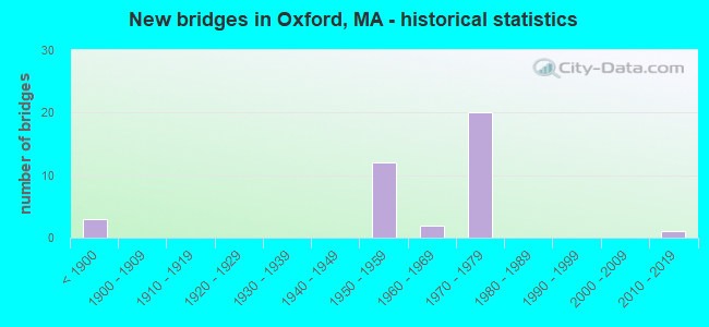
- New bridges - historical statistics
- 3Before 1900
- 121950-1959
- 21960-1969
- 201970-1979
- 12010-2019

- Reconstructed bridges - Historical Statistics
- 11940-1949
- 01950-1959
- 11960-1969
- 01970-1979
- 21980-1989
- 21990-1999


- Bridge Condition - Deck
- 4.0%Very good
- 40.0%Good
- 48.0%Satisfactory
- 8.0%Fair

- Bridge Condition - Superstructure
- 3.4%Very good
- 6.9%Good
- 55.2%Satisfactory
- 27.6%Fair
- 3.4%Poor
- 3.4%Serious

- Bridge Condition - Substructure
- 3.4%Very good
- 44.8%Good
- 37.9%Satisfactory
- 13.8%Fair

- Bridge Condition - Channel
- 17.6%Good
- 23.5%Satisfactory
- 52.9%Fair
- 5.9%Poor

- Bridge Condition - Culverts
- 80.0%Good
- 20.0%Satisfactory
Find on map >> Show street view
Structure Number: O06001BJLMUNNBI, Location: 300 FT E OF ST56 (Lat: 42.187950, Lng: -71.896672), Route carried "on" structure: City street , Year Built: 2014, Status: Open, Structure Length: 1.04m (3.41ft), Average Daily Traffic: 6,254 (year 2015), Truck Traffic: 2%, Design Load: HS 20, Features Intersected: WATER FRENCH RIVER, Facility Carried by Structure: HWY COMINS RD
Minimum Vertical Clearance: 30+ m (98+ ft), Kilometerpoint: 0.050, Lanes on structure: 2, Owner: Town or Township Highway Agency, Approaching Roadway Width: 8.5m (27.9ft), Skew: 2 degrees, Material/Design: Concrete, Design/Construction: Frame, Number Of Spans In Main Unit: 1, Length of Maximum Span: 10.4m (34.1ft), Curb-To-Curb Width: 8.5m (27.9ft), Out-to-Out Width: 12.0m (39.4ft)
Condition: Deck: Very good, Superstructure: Very good, Substructure: Very good, Channel: Good, Operating Rating: 58.3 metric tons, Method Used To Determine Operating Rating: Load and Resistance Factor Rating (LRFR) rating reported by rating factor(RF) method using HL-93 loadings, Inventory Rating: 45.4 metric tons, Method Used To Determine Inventory Rating: Load and Resistance Factor Rating (LRFR) rating reported by rating factor(RF) method using HL-93 loadings, Structural Evaluation: Equal to present desirable criteria, Deck Geometry: High priority of replacement, Waterway Adequacy: Equal to present minimum criteria, Approach Roadway Alignment: Better than present minimum criteria, Designated Inspection Frequency: Every 24 months, Inspection Date: July 2020, Wearing Surface/Protective System: Wearing Surface: Bituminous, Membrane: Preformed Fabric, Deck Protection: Epoxy Coated Reinforcing
Find on map >> Show street view
Structure Number: O060021LGDOTNBI, Location: .1 MI E OF ST-56 (Lat: 42.168028, Lng: -71.891719), Route carried "on" structure: US 20, Year Built: 1956, Status: Open, Structure Length: 2.13m (6.99ft), Average Daily Traffic: 26,203 (year 2018), Truck Traffic: 5%, Average Future Daily Traffic: 36,482 (year 2032), Design Load: H 20, Features Intersected: WATER FRENCH RIVER
Minimum Vertical Clearance: 30+ m (98+ ft), Kilometerpoint: 169.503, Lanes on structure: 4, Base Highway Network: Yes, Owner: State Highway Agency, Approaching Roadway Width: 14.6m (47.9ft), Skew: 2 degrees, Material/Design: Steel, Design/Construction: Stringer/Multi-beam, Number Of Spans In Main Unit: 1, Length of Maximum Span: 19.5m (64.0ft), Curb or Sidewalk Widths: Left: 0.0m, Right: 1.5m (4.9ft), Curb-To-Curb Width: 14.6m (47.9ft), Out-to-Out Width: 17.4m (57.1ft)
Condition: Deck: Fair, Superstructure: Fair, Substructure: Fair, Channel: Fair, Operating Rating: 67.8 metric tons, Method Used To Determine Operating Rating: Load Factor (LF), Inventory Rating: 40.6 metric tons, Method Used To Determine Inventory Rating: Load Factor (LF), Structural Evaluation: Somewhat better than minimum adequacy, Deck Geometry: High priority of replacement, Waterway Adequacy: Equal to present desirable criteria, Approach Roadway Alignment: Equal to present desirable criteria, Length Of Structure Improvement: 2.20m (7.22ft), Designated Inspection Frequency: Every 24 months, Inspection Date: May 2021, Bridge Improvement Cost: $1,504,000, Roadway Improvement Cost: $151,000, Total Project Cost: $2,257,000 ( Estimate for 2022), Deck Structure Type: Concrete Cast-file-Place, Wearing Surface/Protective System: Wearing Surface: Monolithic Concrete
Find on map >> Show street view
Structure Number: O060031Y3DOTNBI, Location: .1 MI.WEST OF ST.12 (Lat: 42.163383, Lng: -71.888322), Route carried "on" structure: State highway 56, Year Built: 1971, Status: Open, Structure Length: 2.44m (8.01ft), Average Daily Traffic: 6,959 (year 2019), Truck Traffic: 9%, Average Future Daily Traffic: 11,055 (year 2031), Design Load: H 20, Features Intersected: WATER FRENCH RIVER
Minimum Vertical Clearance: 30+ m (98+ ft), Kilometerpoint: 0.145, Lanes on structure: 2, Owner: State Highway Agency, Approaching Roadway Width: 13.4m (44.0ft), Skew: 3 degrees, Material/Design: Prestressed concrete, Design/Construction: Stringer/Multi-beam, Number Of Spans In Main Unit: 1, Length of Maximum Span: 23.2m (76.1ft), Curb or Sidewalk Widths: Left: 0.0m, Right: 1.5m (4.9ft), Curb-To-Curb Width: 13.4m (44.0ft), Out-to-Out Width: 16.2m (53.1ft)
Condition: Deck: Satisfactory, Superstructure: Satisfactory, Substructure: Good, Channel: Good, Operating Rating: 51.6 metric tons, Method Used To Determine Operating Rating: Load Factor (LF), Inventory Rating: 31.0 metric tons, Method Used To Determine Inventory Rating: Load Factor (LF), Structural Evaluation: Equal to present minimum criteria, Deck Geometry: Equal to present minimum criteria, Waterway Adequacy: Equal to present desirable criteria, Approach Roadway Alignment: Equal to present desirable criteria, Length Of Structure Improvement: 2.50m (8.20ft), Designated Inspection Frequency: Every 24 months, Inspection Date: April 2020, Bridge Improvement Cost: $1,591,000, Roadway Improvement Cost: $160,000, Total Project Cost: $2,387,000 ( Estimate for 2022), Deck Structure Type: Concrete Cast-file-Place, Wearing Surface/Protective System: Wearing Surface: Bituminous, Membrane: Built-up
Find on map >> Show street view
Structure Number: O060041GYMUNNBI, Location: 0.2 MI WEST OF RTE-12 (Lat: 42.154764, Lng: -71.882492), Route carried "on" structure: City street , Year Built: 1891, Status: Open, Structure Length: 0.91m (2.99ft), Average Daily Traffic: 764 (year 2018), Truck Traffic: 6%, Average Future Daily Traffic: 1,579 (year 2032), Features Intersected: WATER FRENCH RIVER, Facility Carried by Structure: HWY CLARA BTN RD
Minimum Vertical Clearance: 30+ m (98+ ft), Kilometerpoint: 1.110, Lanes on structure: 2, Owner: Town or Township Highway Agency, Approaching Roadway Width: 5.9m (19.4ft), Material/Design: Masonry, Design/Construction: Arch - Deck, Number Of Spans In Main Unit: 1, Length of Maximum Span: 9.1m (29.9ft), Curb-To-Curb Width: 5.9m (19.4ft), Out-to-Out Width: 7.4m (24.3ft)
Condition: Superstructure: Fair, Substructure: Good, Channel: Satisfactory, Structural Evaluation: Somewhat better than minimum adequacy, Waterway Adequacy: Equal to present minimum criteria, Approach Roadway Alignment: Somewhat better than minimum adequacy, Length Of Structure Improvement: 1.60m (5.25ft), Designated Inspection Frequency: Every 24 months, Inspection Date: October 2021, Bridge Improvement Cost: $1,149,000, Roadway Improvement Cost: $115,000, Total Project Cost: $1,724,000 ( Estimate for 2022)
Find on map >> Show street view
Structure Number: O060091D4MUNNBI, Location: .15 MI NW OF DUDLEY RD (Lat: 42.114189, Lng: -71.881517), Route carried "on" structure: City street , Year Built: 1880, Year Reconstructed: 1949, Status: Open, Structure Length: 0.91m (2.99ft), Average Daily Traffic: 6,491 (year 2018), Truck Traffic: 1%, Average Future Daily Traffic: 15,003 (year 2032), Features Intersected: WATER FRENCH RIVER, Facility Carried by Structure: HWY CHARLTON ST
Minimum Vertical Clearance: 30+ m (98+ ft), Kilometerpoint: 1.996, Lanes on structure: 2, Owner: Town or Township Highway Agency, Approaching Roadway Width: 7.9m (25.9ft), Material/Design: Masonry, Design/Construction: Arch - Deck, Number Of Spans In Main Unit: 1, Length of Maximum Span: 9.1m (29.9ft), Curb or Sidewalk Widths: Left: 0.0m, Right: 0.2m (0.7ft), Curb-To-Curb Width: 8.2m (26.9ft), Out-to-Out Width: 11.0m (36.1ft)
Condition: Superstructure: Satisfactory, Substructure: Satisfactory, Channel: Satisfactory, Inventory Rating: 72.6 metric tons, Method Used To Determine Inventory Rating: Load Factor (LF), Structural Evaluation: Equal to present minimum criteria, Deck Geometry: High priority of replacement, Waterway Adequacy: Equal to present minimum criteria, Approach Roadway Alignment: Better than present minimum criteria, Length Of Structure Improvement: 1.00m (3.28ft), Designated Inspection Frequency: Every 24 months, Inspection Date: June 2021, Bridge Improvement Cost: $491,000, Roadway Improvement Cost: $50,000, Total Project Cost: $737,000 ( Estimate for 2022)
Find on map >> Show street view
Structure Number: O060101H0MUNNBI, Location: 200 FT S. BUFFEM DAM RD (Lat: 42.116631, Lng: -71.897583), Route carried "on" structure: City street , Year Built: 1860, Year Reconstructed: 1966, Status: Open, Structure Length: 0.91m (2.99ft), Average Daily Traffic: 4,900 (year 2012), Truck Traffic: 40%, Average Future Daily Traffic: 7,739 (year 2031), Features Intersected: WATER LITTLE RIVER, Facility Carried by Structure: HWY OLD WEBSTER
Minimum Vertical Clearance: 30+ m (98+ ft), Kilometerpoint: 5.021, Lanes on structure: 2, Owner: Town or Township Highway Agency, Approaching Roadway Width: 7.3m (24.0ft), Material/Design: Masonry, Design/Construction: Arch - Deck, Number Of Spans In Main Unit: 2, Length of Maximum Span: 4.0m (13.1ft), Curb-To-Curb Width: 13.0m (42.7ft), Out-to-Out Width: 16.8m (55.1ft)
Condition: Superstructure: Satisfactory, Substructure: Satisfactory, Channel: Fair, Structural Evaluation: Equal to present minimum criteria, Deck Geometry: Equal to present minimum criteria, Waterway Adequacy: Equal to present minimum criteria, Approach Roadway Alignment: Better than present minimum criteria, Length Of Structure Improvement: 1.00m (3.28ft), Designated Inspection Frequency: Every 24 months, Inspection Date: August 2020, Bridge Improvement Cost: $38,000, Roadway Improvement Cost: $4,000, Total Project Cost: $58,000 ( Estimate for 2022)
Find on map >> Show street view
Structure Number: O060111D3MUNNBI, Location: .5 MI SW OF CHARLTON ST (Lat: 42.107106, Lng: -71.883050), Route carried "on" structure: City street , Year Built: 1953, Status: Posted for load, Structure Length: 2.50m (8.20ft), Average Daily Traffic: 6,100 (year 2017), Truck Traffic: 5%, Average Future Daily Traffic: 15,793 (year 2031), Design Load: H 20, Features Intersected: WATER FRENCH RIVER, Facility Carried by Structure: HWY DUDLEY RD
Minimum Vertical Clearance: 30+ m (98+ ft), Kilometerpoint: 2.092, Lanes on structure: 2, Owner: Town or Township Highway Agency, Approaching Roadway Width: 7.3m (24.0ft), Material/Design: Concrete continuous, Design/Construction: Slab, Number Of Spans In Main Unit: 5, Length of Maximum Span: 4.3m (14.1ft), Curb or Sidewalk Widths: Left: 0.6m (2.0ft), Right: 0.3m (1.0ft), Curb-To-Curb Width: 7.3m (24.0ft), Out-to-Out Width: 9.1m (29.9ft)
Condition: Deck: Satisfactory, Superstructure: Satisfactory, Substructure: Satisfactory, Channel: Fair, Operating Rating: 41.7 metric tons, Method Used To Determine Operating Rating: Load Factor (LF), Inventory Rating: 24.9 metric tons, Method Used To Determine Inventory Rating: Load Factor (LF), Structural Evaluation: Equal to present minimum criteria, Deck Geometry: High priority of replacement, Waterway Adequacy: Better than present minimum criteria, Approach Roadway Alignment: Meets minimum limits, Length Of Structure Improvement: 2.60m (8.53ft), Designated Inspection Frequency: Every 24 months, Underwater Inspection Frequency: Every 36 months, Inspection Date: June 2020, Underwater Inspection Date: August 2019, Bridge Improvement Cost: $930,000, Roadway Improvement Cost: $94,000, Total Project Cost: $1,396,000 ( Estimate for 2022), Deck Structure Type: Concrete Cast-file-Place, Wearing Surface/Protective System: Wearing Surface: Bituminous
Find on map >> Show street view
Structure Number: O060121D2MUNNBI, Location: .6 MI SW OF RTE 12 (Lat: 42.091494, Lng: -71.880281), Route carried "on" structure: City street , Year Built: 1955, Status: Posted for load, Structure Length: 3.57m (11.71ft), Average Daily Traffic: 4,759 (year 2020), Truck Traffic: 5%, Average Future Daily Traffic: 8,212 (year 2032), Design Load: H 20, Features Intersected: WATER FRENCH RIVER, Facility Carried by Structure: HWY HARWOOD ST
Minimum Vertical Clearance: 30+ m (98+ ft), Kilometerpoint: 0.177, Lanes on structure: 2, Owner: Town or Township Highway Agency, Approaching Roadway Width: 7.3m (24.0ft), Skew: 4 degrees, Material/Design: Steel continuous, Design/Construction: Stringer/Multi-beam, Number Of Spans In Main Unit: 3, Length of Maximum Span: 21.9m (71.9ft), Curb or Sidewalk Widths: Left: 0.0m, Right: 0.8m (2.6ft), Curb-To-Curb Width: 7.3m (24.0ft), Out-to-Out Width: 9.2m (30.2ft)
Condition: Deck: Good, Superstructure: Satisfactory, Substructure: Good, Channel: Satisfactory, Operating Rating: 36.3 metric tons, Method Used To Determine Operating Rating: Allowable Stress (AS), Inventory Rating: 15.8 metric tons, Method Used To Determine Inventory Rating: Allowable Stress (AS), Structural Evaluation: Meets minimum limits, Deck Geometry: High priority of replacement, Waterway Adequacy: Better than present minimum criteria, Approach Roadway Alignment: Better than present minimum criteria, Length Of Structure Improvement: 3.60m (11.81ft), Designated Inspection Frequency: Every 24 months, Inspection Date: August 2021, Bridge Improvement Cost: $1,301,000, Roadway Improvement Cost: $131,000, Total Project Cost: $1,952,000 ( Estimate for 2022), Deck Structure Type: Concrete Cast-file-Place, Wearing Surface/Protective System: Wearing Surface: Bituminous, Membrane: Built-up
Find on map >> Show street view
Structure Number: O060284M6DOTNBI, Location: NEAR TEXAS POND J8 (Lat: 42.181467, Lng: -71.897769), Route carried "on" structure: Interstate 90, Year Built: 1957, Year Reconstructed: 1986, Status: Open, Structure Length: 4.74m (15.55ft), Average Daily Traffic: 39,545 (year 2020), Truck Traffic: 22%, Average Future Daily Traffic: 78,965 (year 2032), Design Load: HS 20, Features Intersected: ST 56 LEICESTER ST
Minimum Vertical Clearance: 30+ m (98+ ft), Kilometerpoint: 140.975, Lanes on structure: 3, Lanes under structure: 2, Base Highway Network: Yes, Toll: On toll road, Owner: State Highway Agency, Approaching Roadway Width: 16.1m (52.8ft), Skew: 1 degrees, Material/Design: Steel continuous, Design/Construction: Stringer/Multi-beam, Number Of Spans In Main Unit: 3, Length of Maximum Span: 17.6m (57.7ft), Curb-To-Curb Width: 16.1m (52.8ft), Out-to-Out Width: 17.3m (56.8ft)
Condition: Deck: Fair, Superstructure: Satisfactory, Substructure: Good, Operating Rating: 52.2 metric tons, Method Used To Determine Operating Rating: Load Factor (LF), Inventory Rating: 31.3 metric tons, Method Used To Determine Inventory Rating: Load Factor (LF), Structural Evaluation: Equal to present minimum criteria, Deck Geometry: Equal to present minimum criteria, Underclear: Superior to present desirable criteria, Approach Roadway Alignment: Equal to present desirable criteria, Length Of Structure Improvement: 4.80m (15.75ft), Designated Inspection Frequency: Every 24 months, Inspection Date: March 2021, Bridge Improvement Cost: $3,262,000, Roadway Improvement Cost: $327,000, Total Project Cost: $4,894,000 ( Estimate for 2022), Deck Structure Type: Concrete Cast-file-Place, Wearing Surface/Protective System: Wearing Surface: Bituminous, Membrane: Built-up, Deck Protection: Epoxy Coated Reinforcing
Find on map >> Show street view
Structure Number: O060284M7DOTNBI, Location: NEAR TEXAS POND J8 (Lat: 42.181653, Lng: -71.897778), Route carried "on" structure: Interstate 90, Year Built: 1957, Year Reconstructed: 1986, Status: Open, Structure Length: 4.74m (15.55ft), Average Daily Traffic: 38,661 (year 2020), Truck Traffic: 22%, Average Future Daily Traffic: 78,965 (year 2032), Design Load: HS 20, Features Intersected: ST 56 LEICESTER ST
Minimum Vertical Clearance: 99.00m (324.80ft), Kilometerpoint: 140.975, Lanes on structure: 3, Lanes under structure: 2, Base Highway Network: Yes, Toll: On toll road, Owner: State Highway Agency, Approaching Roadway Width: 16.1m (52.8ft), Skew: 1 degrees, Material/Design: Steel continuous, Design/Construction: Stringer/Multi-beam, Number Of Spans In Main Unit: 3, Length of Maximum Span: 17.6m (57.7ft), Curb-To-Curb Width: 16.1m (52.8ft), Out-to-Out Width: 17.3m (56.8ft)
Condition: Deck: Satisfactory, Superstructure: Satisfactory, Substructure: Good, Operating Rating: 52.2 metric tons, Method Used To Determine Operating Rating: Load Factor (LF), Inventory Rating: 31.2 metric tons, Method Used To Determine Inventory Rating: Load Factor (LF), Structural Evaluation: Equal to present minimum criteria, Deck Geometry: Equal to present minimum criteria, Underclear: Superior to present desirable criteria, Approach Roadway Alignment: Equal to present desirable criteria, Length Of Structure Improvement: 4.80m (15.75ft), Designated Inspection Frequency: Every 24 months, Inspection Date: March 2021, Bridge Improvement Cost: $3,262,000, Roadway Improvement Cost: $327,000, Total Project Cost: $4,894,000 ( Estimate for 2022), Deck Structure Type: Concrete Cast-file-Place, Wearing Surface/Protective System: Wearing Surface: Bituminous, Membrane: Built-up, Deck Protection: Epoxy Coated Reinforcing
Find on map >> Show street view
Structure Number: O060301D5MUNNBI, Location: .2 MI S OF LEICESTER T.L. (Lat: 42.188889, Lng: -71.897914), Route carried "on" structure: City street 56, Year Built: 1964, Status: Temporarily open, Structure Length: 2.32m (7.61ft), Average Daily Traffic: 5,949 (year 2020), Truck Traffic: 7%, Average Future Daily Traffic: 11,845 (year 2032), Design Load: H 20, Features Intersected: WATER FRENCH RIVER
Minimum Vertical Clearance: 30+ m (98+ ft), Kilometerpoint: 3.347, Lanes on structure: 3, Owner: Town or Township Highway Agency, Approaching Roadway Width: 13.9m (45.6ft), Skew: 3 degrees, Material/Design: Steel, Design/Construction: Stringer/Multi-beam, Number Of Spans In Main Unit: 1, Length of Maximum Span: 21.9m (71.9ft), Curb-To-Curb Width: 13.9m (45.6ft), Out-to-Out Width: 14.9m (48.9ft)
Condition: Deck: Satisfactory, Superstructure: Serious, Substructure: Good, Channel: Poor, Operating Rating: 55.5 metric tons, Method Used To Determine Operating Rating: Load Factor (LF), Inventory Rating: 33.3 metric tons, Method Used To Determine Inventory Rating: Load Factor (LF), Structural Evaluation: High priority of corrective action, Deck Geometry: Somewhat better than minimum adequacy, Waterway Adequacy: Equal to present desirable criteria, Approach Roadway Alignment: Better than present minimum criteria, Length Of Structure Improvement: 2.40m (7.87ft), Designated Inspection Frequency: Every 6 months, Other Special Inspection Frequency: Every 6 months, Inspection Date: June 2021, Other Special Inspection Date: December 2021, Bridge Improvement Cost: $1,405,000, Roadway Improvement Cost: $141,000, Total Project Cost: $2,108,000 ( Estimate for 2022), Deck Structure Type: Concrete Cast-file-Place, Wearing Surface/Protective System: Wearing Surface: Bituminous, Membrane: Built-up
Find on map >> Show street view
Structure Number: O060321PWDOTNBI, Location: .1 MI EAST OF ST-12 (Lat: 42.080953, Lng: -71.866361), Route carried "on" structure: City street , Year Built: 1969, Status: Open, Structure Length: 7.89m (25.89ft), Average Daily Traffic: 7,827 (year 2019), Truck Traffic: 5%, Average Future Daily Traffic: 6,981 (year 2032), Design Load: H 20, Features Intersected: I 395, Facility Carried by Structure: HWY CUDWORTH RD
Minimum Vertical Clearance: 30+ m (98+ ft), Kilometerpoint: 0.161, Lanes on structure: 2, Lanes under structure: 4, Owner: State Highway Agency, Approaching Roadway Width: 13.4m (44.0ft), Skew: 9 degrees, Material/Design: Steel, Design/Construction: Stringer/Multi-beam, Number Of Spans In Main Unit: 2, Length of Maximum Span: 40.2m (131.9ft), Curb or Sidewalk Widths: Left: 1.7m (5.6ft), Right: 0.0m, Curb-To-Curb Width: 13.4m (44.0ft), Out-to-Out Width: 16.8m (55.1ft)
Condition: Deck: Good, Superstructure: Satisfactory, Substructure: Satisfactory, Operating Rating: 54.1 metric tons, Method Used To Determine Operating Rating: Load Factor (LF), Inventory Rating: 32.4 metric tons, Method Used To Determine Inventory Rating: Load Factor (LF), Structural Evaluation: Equal to present minimum criteria, Deck Geometry: Equal to present minimum criteria, Underclear: Meets minimum limits, Length Of Structure Improvement: 9.00m (29.53ft), Designated Inspection Frequency: Every 24 months, Inspection Date: May 2021, Bridge Improvement Cost: $7,920,000, Roadway Improvement Cost: $793,000, Total Project Cost: $11,881,000 ( Estimate for 2022), Deck Structure Type: Concrete Cast-file-Place, Wearing Surface/Protective System: Wearing Surface: Bituminous, Membrane: Built-up
Find on map >> Show street view
Structure Number: O060331PXDOTNBI, Location: 1.2 MI SO. OF SUTTON ROAD (Lat: 42.098172, Lng: -71.859919), Route carried "on" structure: City street , Year Built: 1973, Status: Open, Structure Length: 10.06m (33.01ft), Average Daily Traffic: 930 (year 2000), Truck Traffic: 5%, Average Future Daily Traffic: 632 (year 2031), Design Load: H 20, Features Intersected: I 395, Facility Carried by Structure: HWY HOLBROOK RD
Minimum Vertical Clearance: 30+ m (98+ ft), Kilometerpoint: 0.966, Lanes on structure: 2, Lanes under structure: 4, Owner: State Highway Agency, Approaching Roadway Width: 9.8m (32.2ft), Skew: 3 degrees, Material/Design: Steel continuous, Design/Construction: Stringer/Multi-beam, Number Of Spans In Main Unit: 2, Length of Maximum Span: 49.1m (161.1ft), Curb or Sidewalk Widths: Left: 1.8m (5.9ft), Right: 0.0m, Curb-To-Curb Width: 9.8m (32.2ft), Out-to-Out Width: 12.8m (42.0ft)
Condition: Deck: Good, Superstructure: Satisfactory, Substructure: Satisfactory, Operating Rating: 71.0 metric tons, Method Used To Determine Operating Rating: Load Factor (LF), Inventory Rating: 42.5 metric tons, Method Used To Determine Inventory Rating: Load Factor (LF), Structural Evaluation: Equal to present minimum criteria, Deck Geometry: Equal to present minimum criteria, Underclear: Superior to present desirable criteria, Approach Roadway Alignment: Equal to present desirable criteria, Length Of Structure Improvement: 10.10m (33.14ft), Designated Inspection Frequency: Every 24 months, Inspection Date: November 2020, Bridge Improvement Cost: $2,286,000, Roadway Improvement Cost: $229,000, Total Project Cost: $3,430,000 ( Estimate for 2022), Deck Structure Type: Concrete Cast-file-Place, Wearing Surface/Protective System: Wearing Surface: Bituminous, Membrane: Built-up
Find on map >> Show street view
Structure Number: O060341PYDOTNBI, Location: .5 MI E OF ST-12 (Lat: 42.105750, Lng: -71.856256), Route carried "on" structure: City street , Year Built: 1973, Status: Open, Structure Length: 8.08m (26.51ft), Average Daily Traffic: 1,000 (year 2013), Truck Traffic: 2%, Average Future Daily Traffic: 1,579 (year 2032), Design Load: H 20, Features Intersected: I 395, Facility Carried by Structure: HWY HUGUENOT RD
Minimum Vertical Clearance: 30+ m (98+ ft), Kilometerpoint: 0.000, Lanes on structure: 2, Lanes under structure: 4, Owner: State Highway Agency, Approaching Roadway Width: 11.0m (36.1ft), Skew: 1 degrees, Material/Design: Steel continuous, Design/Construction: Stringer/Multi-beam, Number Of Spans In Main Unit: 2, Length of Maximum Span: 39.9m (130.9ft), Curb or Sidewalk Widths: Left: 0.5m (1.6ft), Right: 1.5m (4.9ft), Curb-To-Curb Width: 11.0m (36.1ft), Out-to-Out Width: 13.7m (44.9ft)
Condition: Deck: Good, Superstructure: Fair, Substructure: Good, Operating Rating: 58.6 metric tons, Method Used To Determine Operating Rating: Load Factor (LF), Inventory Rating: 35.1 metric tons, Method Used To Determine Inventory Rating: Load Factor (LF), Structural Evaluation: Somewhat better than minimum adequacy, Deck Geometry: Better than present minimum criteria, Underclear: Better than present minimum criteria, Approach Roadway Alignment: Equal to present desirable criteria, Length Of Structure Improvement: 8.10m (26.57ft), Designated Inspection Frequency: Every 24 months, Inspection Date: December 2021, Bridge Improvement Cost: $4,359,000, Roadway Improvement Cost: $436,000, Total Project Cost: $6,539,000 ( Estimate for 2022), Deck Structure Type: Concrete Cast-file-Place, Wearing Surface/Protective System: Wearing Surface: Bituminous, Membrane: Built-up
Find on map >> Show street view
Structure Number: O060351Q2DOTNBI, Location: .4 MI. E. OF ST-12 (Lat: 42.116417, Lng: -71.855028), Route carried "on" structure: City street , Year Built: 1973, Status: Open, Structure Length: 6.93m (22.74ft), Average Daily Traffic: 4,100 (year 2014), Truck Traffic: 5%, Average Future Daily Traffic: 6,475 (year 2033), Design Load: HS 20, Features Intersected: I 395, Facility Carried by Structure: HWY SUTTON AVE
Minimum Vertical Clearance: 30+ m (98+ ft), Kilometerpoint: 0.800, Lanes on structure: 6, Lanes under structure: 6, Owner: State Highway Agency, Approaching Roadway Width: 23.8m (78.1ft), Skew: 20 degrees, Material/Design: Steel continuous, Design/Construction: Stringer/Multi-beam, Number Of Spans In Main Unit: 2, Length of Maximum Span: 33.6m (110.2ft), Curb or Sidewalk Widths: Left: 0.5m (1.6ft), Right: 1.5m (4.9ft), Curb-To-Curb Width: 23.8m (78.1ft), Out-to-Out Width: 26.6m (87.3ft)
Condition: Deck: Good, Superstructure: Fair, Substructure: Satisfactory, Operating Rating: 49.9 metric tons, Method Used To Determine Operating Rating: Load Factor (LF), Inventory Rating: 29.9 metric tons, Method Used To Determine Inventory Rating: Load Factor (LF), Structural Evaluation: Somewhat better than minimum adequacy, Deck Geometry: Somewhat better than minimum adequacy, Underclear: Superior to present desirable criteria, Approach Roadway Alignment: Equal to present desirable criteria, Length Of Structure Improvement: 7.00m (22.97ft), Designated Inspection Frequency: Every 24 months, Inspection Date: January 2022, Bridge Improvement Cost: $7,314,000, Roadway Improvement Cost: $732,000, Total Project Cost: $10,972,000 ( Estimate for 2022), Deck Structure Type: Concrete Cast-file-Place, Wearing Surface/Protective System: Wearing Surface: Bituminous, Membrane: Built-up
Find on map >> Show street view
Structure Number: O060361Q3DOTNBI, Location: I-395 MM 7.6 (Lat: 42.131106, Lng: -71.857008), Route carried "on" structure: Interstate 395, Year Built: 1973, Status: Open, Structure Length: 2.38m (7.81ft), Average Daily Traffic: 29,401 (year 2019), Truck Traffic: 6%, Average Future Daily Traffic: 63,172 (year 2031), Design Load: HS 20, Features Intersected: HWY DANA RD
Minimum Vertical Clearance: 30+ m (98+ ft), Kilometerpoint: 12.261, Lanes on structure: 2, Lanes under structure: 2, Base Highway Network: Yes, Owner: State Highway Agency, Approaching Roadway Width: 12.2m (40.0ft), Material/Design: Steel, Design/Construction: Stringer/Multi-beam, Number Of Spans In Main Unit: 1, Length of Maximum Span: 21.9m (71.9ft), Curb or Sidewalk Widths: Left: 0.3m (1.0ft), Right: 0.3m (1.0ft), Curb-To-Curb Width: 12.3m (40.4ft), Out-to-Out Width: 13.8m (45.3ft)
Condition: Deck: Good, Superstructure: Satisfactory, Substructure: Good, Operating Rating: 59.5 metric tons, Method Used To Determine Operating Rating: Allowable Stress (AS), Inventory Rating: 32.4 metric tons, Method Used To Determine Inventory Rating: Allowable Stress (AS), Structural Evaluation: Equal to present minimum criteria, Deck Geometry: Better than present minimum criteria, Underclear: High priority of corrective action, Approach Roadway Alignment: Equal to present desirable criteria, Length Of Structure Improvement: 2.40m (7.87ft), Designated Inspection Frequency: Every 24 months, Inspection Date: June 2020, Bridge Improvement Cost: $114,000, Roadway Improvement Cost: $12,000, Total Project Cost: $172,000 ( Estimate for 2022), Deck Structure Type: Concrete Cast-file-Place, Wearing Surface/Protective System: Wearing Surface: Bituminous, Membrane: Built-up
Find on map >> Show street view
Structure Number: O060361Q4DOTNBI, Location: .6 MI. N. OF SUTTON AVE. (Lat: 42.131122, Lng: -71.857517), Route carried "on" structure: Interstate 395, Year Built: 1973, Status: Open, Structure Length: 2.38m (7.81ft), Average Daily Traffic: 20,637 (year 2015), Truck Traffic: 15%, Average Future Daily Traffic: 63,172 (year 2031), Design Load: HS 20, Features Intersected: HWY DANA RD
Minimum Vertical Clearance: 30+ m (98+ ft), Kilometerpoint: 12.261, Lanes on structure: 2, Lanes under structure: 2, Base Highway Network: Yes, Owner: State Highway Agency, Approaching Roadway Width: 12.2m (40.0ft), Material/Design: Steel, Design/Construction: Stringer/Multi-beam, Number Of Spans In Main Unit: 1, Length of Maximum Span: 21.9m (71.9ft), Curb or Sidewalk Widths: Left: 0.3m (1.0ft), Right: 0.3m (1.0ft), Curb-To-Curb Width: 11.6m (38.1ft), Out-to-Out Width: 13.8m (45.3ft)
Condition: Deck: Good, Superstructure: Satisfactory, Substructure: Good, Operating Rating: 59.5 metric tons, Method Used To Determine Operating Rating: Allowable Stress (AS), Inventory Rating: 32.4 metric tons, Method Used To Determine Inventory Rating: Allowable Stress (AS), Structural Evaluation: Equal to present minimum criteria, Deck Geometry: Equal to present minimum criteria, Underclear: High priority of corrective action, Approach Roadway Alignment: Equal to present desirable criteria, Length Of Structure Improvement: 2.40m (7.87ft), Designated Inspection Frequency: Every 24 months, Inspection Date: June 2020, Bridge Improvement Cost: $272,000, Roadway Improvement Cost: $28,000, Total Project Cost: $409,000 ( Estimate for 2022), Deck Structure Type: Concrete Cast-file-Place, Wearing Surface/Protective System: Wearing Surface: Bituminous, Membrane: Built-up
Find on map >> Show street view
Structure Number: O060371Q5DOTNBI, Location: MM 8.2 (Lat: 42.138664, Lng: -71.856078), Route carried "on" structure: Interstate 395, Year Built: 1976, Status: Open, Structure Length: 2.41m (7.91ft), Average Daily Traffic: 29,401 (year 2019), Truck Traffic: 6%, Average Future Daily Traffic: 33,165 (year 2032), Design Load: HS 20, Features Intersected: HWY FEDERAL HILL RD
Minimum Vertical Clearance: 30+ m (98+ ft), Kilometerpoint: 13.068, Lanes on structure: 2, Lanes under structure: 2, Base Highway Network: Yes, Owner: State Highway Agency, Approaching Roadway Width: 12.5m (41.0ft), Material/Design: Steel, Design/Construction: Stringer/Multi-beam, Number Of Spans In Main Unit: 1, Length of Maximum Span: 21.6m (70.9ft), Curb-To-Curb Width: 12.3m (40.4ft), Out-to-Out Width: 13.7m (44.9ft)
Condition: Deck: Satisfactory, Superstructure: Satisfactory, Substructure: Good, Operating Rating: 59.9 metric tons, Method Used To Determine Operating Rating: Allowable Stress (AS), Inventory Rating: 31.7 metric tons, Method Used To Determine Inventory Rating: Allowable Stress (AS), Structural Evaluation: Equal to present minimum criteria, Deck Geometry: Better than present minimum criteria, Underclear: High priority of corrective action, Approach Roadway Alignment: Equal to present desirable criteria, Length Of Structure Improvement: 2.50m (8.20ft), Designated Inspection Frequency: Every 24 months, Inspection Date: Febuary 2021, Bridge Improvement Cost: $1,346,000, Roadway Improvement Cost: $135,000, Total Project Cost: $2,020,000 ( Estimate for 2022), Deck Structure Type: Concrete Cast-file-Place, Wearing Surface/Protective System: Wearing Surface: Bituminous, Membrane: Built-up
Find on map >> Show street view
Structure Number: O060371Q6DOTNBI, Location: MM 8.2 (Lat: 42.138653, Lng: -71.856661), Route carried "on" structure: Interstate 395, Year Built: 1976, Status: Open, Structure Length: 2.41m (7.91ft), Average Daily Traffic: 25,374 (year 2019), Truck Traffic: 6%, Average Future Daily Traffic: 28,427 (year 2032), Design Load: HS 20, Features Intersected: HWY FEDERAL HILL RD
Minimum Vertical Clearance: 30+ m (98+ ft), Kilometerpoint: 13.068, Lanes on structure: 2, Lanes under structure: 2, Base Highway Network: Yes, Owner: State Highway Agency, Approaching Roadway Width: 12.5m (41.0ft), Material/Design: Steel, Design/Construction: Stringer/Multi-beam, Number Of Spans In Main Unit: 1, Length of Maximum Span: 21.6m (70.9ft), Curb or Sidewalk Widths: Left: 0.2m (0.7ft), Right: 0.2m (0.7ft), Curb-To-Curb Width: 12.3m (40.4ft), Out-to-Out Width: 13.7m (44.9ft)
Condition: Deck: Satisfactory, Superstructure: Good, Substructure: Good, Operating Rating: 59.9 metric tons, Method Used To Determine Operating Rating: Allowable Stress (AS), Inventory Rating: 31.7 metric tons, Method Used To Determine Inventory Rating: Allowable Stress (AS), Structural Evaluation: Better than present minimum criteria, Deck Geometry: Better than present minimum criteria, Underclear: High priority of corrective action, Approach Roadway Alignment: Equal to present desirable criteria, Length Of Structure Improvement: 2.50m (8.20ft), Designated Inspection Frequency: Every 24 months, Inspection Date: Febuary 2021, Bridge Improvement Cost: $1,346,000, Roadway Improvement Cost: $135,000, Total Project Cost: $2,020,000 ( Estimate for 2022), Deck Structure Type: Concrete Cast-file-Place, Wearing Surface/Protective System: Wearing Surface: Bituminous, Membrane: Built-up
Find on map >> Show street view
Structure Number: O060381Q7DOTNBI, Location: .5 MI. S. OF DEPOT RD. (Lat: 42.143803, Lng: -71.856889), Route carried "on" structure: Interstate 395, Year Built: 1976, Status: Open, Structure Length: 3.41m (11.19ft), Average Daily Traffic: 29,401 (year 2019), Truck Traffic: 6%, Average Future Daily Traffic: 34,745 (year 2032), Design Load: HS 20, Features Intersected: HWY MILLBURY RD
Minimum Vertical Clearance: 30+ m (98+ ft), Kilometerpoint: 13.727, Lanes on structure: 2, Lanes under structure: 2, Base Highway Network: Yes, Owner: State Highway Agency, Approaching Roadway Width: 12.5m (41.0ft), Skew: 4 degrees, Material/Design: Steel, Design/Construction: Stringer/Multi-beam, Number Of Spans In Main Unit: 1, Length of Maximum Span: 30.5m (100.1ft), Curb-To-Curb Width: 12.3m (40.4ft), Out-to-Out Width: 13.7m (44.9ft)
Condition: Deck: Satisfactory, Superstructure: Satisfactory, Substructure: Good, Operating Rating: 63.8 metric tons, Method Used To Determine Operating Rating: Allowable Stress (AS), Inventory Rating: 33.0 metric tons, Method Used To Determine Inventory Rating: Allowable Stress (AS), Structural Evaluation: Equal to present minimum criteria, Deck Geometry: Better than present minimum criteria, Underclear: High priority of replacement, Length Of Structure Improvement: 4.40m (14.44ft), Designated Inspection Frequency: Every 24 months, Inspection Date: Febuary 2021, Bridge Improvement Cost: $3,273,000, Roadway Improvement Cost: $328,000, Total Project Cost: $4,910,000 ( Estimate for 2022), Deck Structure Type: Concrete Cast-file-Place, Wearing Surface/Protective System: Wearing Surface: Bituminous, Membrane: Built-up
Find on map >> Show street view
Structure Number: O060381Q8DOTNBI, Location: .5 MI. S. OF DEPOT RD. (Lat: 42.143461, Lng: -71.857311), Route carried "on" structure: Interstate 395, Year Built: 1976, Status: Open, Structure Length: 3.41m (11.19ft), Average Daily Traffic: 25,374 (year 2019), Truck Traffic: 6%, Average Future Daily Traffic: 34,745 (year 2032), Design Load: HS 20, Features Intersected: HWY MILLBURY RD
Minimum Vertical Clearance: 30+ m (98+ ft), Kilometerpoint: 13.727, Lanes on structure: 2, Lanes under structure: 2, Base Highway Network: Yes, Owner: State Highway Agency, Approaching Roadway Width: 12.5m (41.0ft), Skew: 14 degrees, Material/Design: Steel, Design/Construction: Stringer/Multi-beam, Number Of Spans In Main Unit: 1, Length of Maximum Span: 30.5m (100.1ft), Curb-To-Curb Width: 12.3m (40.4ft), Out-to-Out Width: 13.7m (44.9ft)
Condition: Deck: Satisfactory, Superstructure: Fair, Substructure: Satisfactory, Operating Rating: 63.8 metric tons, Method Used To Determine Operating Rating: Allowable Stress (AS), Inventory Rating: 33.0 metric tons, Method Used To Determine Inventory Rating: Allowable Stress (AS), Structural Evaluation: Somewhat better than minimum adequacy, Deck Geometry: Better than present minimum criteria, Underclear: High priority of corrective action, Approach Roadway Alignment: Equal to present desirable criteria, Length Of Structure Improvement: 3.50m (11.48ft), Designated Inspection Frequency: Every 24 months, Inspection Date: Febuary 2021, Bridge Improvement Cost: $1,884,000, Roadway Improvement Cost: $189,000, Total Project Cost: $2,827,000 ( Estimate for 2022), Deck Structure Type: Concrete Cast-file-Place, Wearing Surface/Protective System: Wearing Surface: Bituminous, Membrane: Built-up
Find on map >> Show street view
Structure Number: O060391Q9DOTNBI, Location: .5 MILE SOUTH OF DEPOT RD (Lat: 42.144656, Lng: -71.857053), Route carried "on" structure: Interstate 395, Year Built: 1976, Status: Open, Structure Length: 2.87m (9.42ft), Average Daily Traffic: 22,826 (year 2020), Truck Traffic: 6%, Average Future Daily Traffic: 64,751 (year 2032), Design Load: HS 20, Features Intersected: RR PWRR
Minimum Vertical Clearance: 30+ m (98+ ft), Kilometerpoint: 13.679, Lanes on structure: 2, Base Highway Network: Yes, Owner: State Highway Agency, Approaching Roadway Width: 12.8m (42.0ft), Skew: 13 degrees, Material/Design: Steel, Design/Construction: Stringer/Multi-beam, Number Of Spans In Main Unit: 1, Length of Maximum Span: 26.2m (86.0ft), Curb or Sidewalk Widths: Left: 0.2m (0.7ft), Right: 0.2m (0.7ft), Curb-To-Curb Width: 12.8m (42.0ft), Out-to-Out Width: 13.7m (44.9ft)
Condition: Deck: Satisfactory, Superstructure: Satisfactory, Substructure: Satisfactory, Operating Rating: 52.5 metric tons, Method Used To Determine Operating Rating: Allowable Stress (AS), Inventory Rating: 31.7 metric tons, Method Used To Determine Inventory Rating: Allowable Stress (AS), Structural Evaluation: Equal to present minimum criteria, Deck Geometry: Equal to present desirable criteria, Underclear: High priority of corrective action, Approach Roadway Alignment: Equal to present desirable criteria, Length Of Structure Improvement: 2.90m (9.51ft), Designated Inspection Frequency: Every 24 months, Inspection Date: May 2021, Bridge Improvement Cost: $1,561,000, Roadway Improvement Cost: $157,000, Total Project Cost: $2,342,000 ( Estimate for 2022), Deck Structure Type: Concrete Cast-file-Place, Wearing Surface/Protective System: Wearing Surface: Bituminous, Membrane: Built-up
Find on map >> Show street view
Structure Number: O060391QADOTNBI, Location: MM 8.6 (Lat: 42.144378, Lng: -71.857475), Route carried "on" structure: Interstate 395, Year Built: 1976, Status: Open, Structure Length: 2.80m (9.19ft), Average Daily Traffic: 24,986 (year 2018), Truck Traffic: 6%, Average Future Daily Traffic: 39,482 (year 2032), Design Load: HS 20, Features Intersected: RR PWRR
Minimum Vertical Clearance: 30+ m (98+ ft), Kilometerpoint: 13.679, Lanes on structure: 2, Base Highway Network: Yes, Owner: State Highway Agency, Approaching Roadway Width: 12.8m (42.0ft), Skew: 3 degrees, Material/Design: Steel, Design/Construction: Stringer/Multi-beam, Number Of Spans In Main Unit: 1, Length of Maximum Span: 25.6m (84.0ft), Curb or Sidewalk Widths: Left: 0.2m (0.7ft), Right: 0.2m (0.7ft), Curb-To-Curb Width: 12.8m (42.0ft), Out-to-Out Width: 13.7m (44.9ft)
Condition: Deck: Good, Superstructure: Fair, Substructure: Fair, Operating Rating: 63.8 metric tons, Method Used To Determine Operating Rating: Allowable Stress (AS), Inventory Rating: 33.3 metric tons, Method Used To Determine Inventory Rating: Allowable Stress (AS), Structural Evaluation: Somewhat better than minimum adequacy, Deck Geometry: Equal to present desirable criteria, Underclear: High priority of corrective action, Approach Roadway Alignment: Equal to present desirable criteria, Length Of Structure Improvement: 2.90m (9.51ft), Designated Inspection Frequency: Every 24 months, Inspection Date: May 2021, Bridge Improvement Cost: $1,561,000, Roadway Improvement Cost: $157,000, Total Project Cost: $2,342,000 ( Estimate for 2022), Deck Structure Type: Concrete Cast-file-Place, Wearing Surface/Protective System: Wearing Surface: Bituminous, Membrane: Built-up
Find on map >> Show street view
Structure Number: O060401QDDOTNBI, Location: .5MI. E. OF ST-12 (Lat: 42.150928, Lng: -71.856928), Route carried "on" structure: City street , Year Built: 1976, Status: Open, Structure Length: 8.11m (26.61ft), Average Daily Traffic: 4,495 (year 2020), Truck Traffic: 6%, Average Future Daily Traffic: 6,633 (year 2032), Design Load: HS 20, Features Intersected: I 395, Facility Carried by Structure: HWY DEPOT RD
Minimum Vertical Clearance: 30+ m (98+ ft), Kilometerpoint: 0.805, Lanes on structure: 2, Lanes under structure: 5, Owner: State Highway Agency, Approaching Roadway Width: 21.9m (71.9ft), Skew: 22 degrees, Material/Design: Steel continuous, Design/Construction: Stringer/Multi-beam, Number Of Spans In Main Unit: 2, Length of Maximum Span: 39.6m (129.9ft), Curb or Sidewalk Widths: Left: 1.9m (6.2ft), Right: 0.9m (3.0ft), Curb-To-Curb Width: 21.9m (71.9ft), Out-to-Out Width: 26.6m (87.3ft)
Condition: Deck: Satisfactory, Superstructure: Fair, Substructure: Fair, Operating Rating: 46.5 metric tons, Method Used To Determine Operating Rating: Load Factor (LF), Inventory Rating: 29.4 metric tons, Method Used To Determine Inventory Rating: Load Factor (LF), Structural Evaluation: Somewhat better than minimum adequacy, Deck Geometry: Superior to present desirable criteria, Underclear: High priority of corrective action, Approach Roadway Alignment: Superior to present desirable criteria, Length Of Structure Improvement: 8.20m (26.90ft), Designated Inspection Frequency: Every 24 months, Inspection Date: July 2021, Bridge Improvement Cost: $8,568,000, Roadway Improvement Cost: $857,000, Total Project Cost: $12,853,000 ( Estimate for 2022), Deck Structure Type: Concrete Cast-file-Place, Wearing Surface/Protective System: Wearing Surface: Bituminous, Membrane: Built-up
Find on map >> Show street view
Structure Number: O060411Q0DOTNBI, Location: .4M S. OF SUTTON AVE. (Lat: 42.110283, Lng: -71.854881), Route carried "on" structure: Interstate 395, Year Built: 1973, Status: Open, Structure Length: 2.29m (7.51ft), Average Daily Traffic: 21,268 (year 2018), Truck Traffic: 4%, Average Future Daily Traffic: 44,220 (year 2032), Design Load: HS 20, Features Intersected: WATER LOWES POND
Minimum Vertical Clearance: 30+ m (98+ ft), Kilometerpoint: 9.913, Lanes on structure: 3, Base Highway Network: Yes, Owner: State Highway Agency, Approaching Roadway Width: 12.8m (42.0ft), Material/Design: Prestressed concrete, Design/Construction: Stringer/Multi-beam, Number Of Spans In Main Unit: 1, Length of Maximum Span: 20.7m (67.9ft), Curb or Sidewalk Widths: Left: 0.2m (0.7ft), Right: 0.2m (0.7ft), Curb-To-Curb Width: 12.8m (42.0ft), Out-to-Out Width: 14.3m (46.9ft)
Condition: Deck: Satisfactory, Superstructure: Fair, Substructure: Satisfactory, Channel: Fair, Operating Rating: 51.6 metric tons, Method Used To Determine Operating Rating: Load Factor (LF), Inventory Rating: 30.9 metric tons, Method Used To Determine Inventory Rating: Load Factor (LF), Structural Evaluation: Somewhat better than minimum adequacy, Deck Geometry: High priority of replacement, Waterway Adequacy: Superior to present desirable criteria, Approach Roadway Alignment: Equal to present desirable criteria, Length Of Structure Improvement: 2.30m (7.55ft), Designated Inspection Frequency: Every 24 months, Inspection Date: May 2021, Bridge Improvement Cost: $1,292,000, Roadway Improvement Cost: $130,000, Total Project Cost: $1,939,000 ( Estimate for 2022), Deck Structure Type: Concrete Cast-file-Place, Wearing Surface/Protective System: Wearing Surface: Bituminous, Membrane: Built-up
Find on map >> Show street view
Structure Number: O060411Q1DOTNBI, Location: JUST S. OF SUTTON AVE. (Lat: 42.110250, Lng: -71.855444), Route carried "on" structure: Interstate 395, Year Built: 1973, Status: Open, Structure Length: 2.29m (7.51ft), Average Daily Traffic: 21,156 (year 2019), Truck Traffic: 5%, Average Future Daily Traffic: 44,220 (year 2032), Design Load: HS 20, Features Intersected: WATER LOWES POND
Minimum Vertical Clearance: 30+ m (98+ ft), Kilometerpoint: 9.913, Lanes on structure: 2, Base Highway Network: Yes, Owner: State Highway Agency, Approaching Roadway Width: 12.8m (42.0ft), Material/Design: Prestressed concrete, Design/Construction: Stringer/Multi-beam, Number Of Spans In Main Unit: 1, Length of Maximum Span: 20.7m (67.9ft), Curb or Sidewalk Widths: Left: 0.3m (1.0ft), Right: 0.3m (1.0ft), Curb-To-Curb Width: 12.8m (42.0ft), Out-to-Out Width: 14.3m (46.9ft)
Condition: Deck: Satisfactory, Superstructure: Poor, Substructure: Satisfactory, Channel: Fair, Operating Rating: 51.6 metric tons, Method Used To Determine Operating Rating: Load Factor (LF), Inventory Rating: 30.9 metric tons, Method Used To Determine Inventory Rating: Load Factor (LF), Structural Evaluation: Meets minimum limits, Deck Geometry: Equal to present desirable criteria, Waterway Adequacy: Superior to present desirable criteria, Approach Roadway Alignment: Equal to present desirable criteria, Length Of Structure Improvement: 3.20m (10.50ft), Designated Inspection Frequency: Every 12 months, Other Special Inspection Frequency: Every 12 months, Inspection Date: May 2021, Other Special Inspection Date: May 2021, Bridge Improvement Cost: $2,397,000, Roadway Improvement Cost: $240,000, Total Project Cost: $3,596,000 ( Estimate for 2022), Deck Structure Type: Concrete Cast-file-Place, Wearing Surface/Protective System: Wearing Surface: Bituminous, Membrane: Built-up
Find on map >> Show street view
Structure Number: O060421QBDOTNBI, Location: .1MI. S. OF DEPOT RD. (Lat: 42.149750, Lng: -71.856975), Route carried "on" structure: Interstate 395, Year Built: 1976, Status: Open, Structure Length: 0.70m (2.30ft), Average Daily Traffic: 22,826 (year 2020), Truck Traffic: 15%, Average Future Daily Traffic: 39,482 (year 2032), Design Load: HS 20, Features Intersected: WATER WELLINGTON BROOK
Minimum Vertical Clearance: 30+ m (98+ ft), Kilometerpoint: 14.323, Lanes on structure: 3, Base Highway Network: Yes, Owner: State Highway Agency, Approaching Roadway Width: 12.2m (40.0ft), Material/Design: Concrete, Design/Construction: Culvert, Number Of Spans In Main Unit: 2, Length of Maximum Span: 3.0m (9.8ft)
Condition: Channel: Fair, Culverts: Good, Inventory Rating: 58.2 metric tons, Method Used To Determine Inventory Rating: Allowable Stress (AS), Structural Evaluation: Better than present minimum criteria, Waterway Adequacy: Better than present minimum criteria, Approach Roadway Alignment: Equal to present desirable criteria, Length Of Structure Improvement: 0.70m (2.30ft), Designated Inspection Frequency: Every 24 months, Inspection Date: August 2021, Bridge Improvement Cost: $462,000, Roadway Improvement Cost: $47,000, Total Project Cost: $694,000 ( Estimate for 2022)
Find on map >> Show street view
Structure Number: O060421QCDOTNBI, Location: .1 MI S OF DEPOT RD (Lat: 42.149831, Lng: -71.857500), Route carried "on" structure: Interstate 395, Year Built: 1976, Status: Open, Structure Length: 0.69m (2.26ft), Average Daily Traffic: 27,053 (year 2018), Truck Traffic: 15%, Average Future Daily Traffic: 39,482 (year 2032), Design Load: HS 20, Features Intersected: WATER WELLINGTON BROOK
Minimum Vertical Clearance: 30+ m (98+ ft), Kilometerpoint: 14.323, Lanes on structure: 3, Base Highway Network: Yes, Owner: State Highway Agency, Approaching Roadway Width: 12.2m (40.0ft), Material/Design: Concrete, Design/Construction: Culvert, Number Of Spans In Main Unit: 2, Length of Maximum Span: 3.2m (10.5ft)
Condition: Channel: Fair, Culverts: Good, Inventory Rating: 56.3 metric tons, Method Used To Determine Inventory Rating: Allowable Stress (AS), Structural Evaluation: Better than present minimum criteria, Waterway Adequacy: Better than present minimum criteria, Approach Roadway Alignment: Equal to present desirable criteria, Length Of Structure Improvement: 0.70m (2.30ft), Designated Inspection Frequency: Every 24 months, Inspection Date: August 2021, Bridge Improvement Cost: $453,000, Roadway Improvement Cost: $46,000, Total Project Cost: $680,000 ( Estimate for 2022)
Find on map >> Show street view
Structure Number: O060431QEDOTNBI, Location: ON RAMP SOUTH EXIT 5 (Lat: 42.149158, Lng: -71.859086), Route carried "on" structure: Interstate 395, Year Built: 1976, Status: Open, Structure Length: 0.64m (2.10ft), Average Daily Traffic: 1,322 (year 2019), Truck Traffic: 7%, Average Future Daily Traffic: 4,517 (year 2032), Design Load: HS 20, Features Intersected: WATER WELLINGTON BROOK
Minimum Vertical Clearance: 30+ m (98+ ft), Kilometerpoint: 0.000, Lanes on structure: 1, Base Highway Network: Yes, Owner: State Highway Agency, Approaching Roadway Width: 6.7m (22.0ft), Material/Design: Concrete, Design/Construction: Culvert, Number Of Spans In Main Unit: 2, Length of Maximum Span: 3.0m (9.8ft)
Condition: Channel: Satisfactory, Culverts: Satisfactory, Inventory Rating: 55.2 metric tons, Method Used To Determine Inventory Rating: Allowable Stress (AS), Structural Evaluation: Equal to present minimum criteria, Waterway Adequacy: Equal to present desirable criteria, Approach Roadway Alignment: Equal to present desirable criteria, Length Of Structure Improvement: 0.70m (2.30ft), Designated Inspection Frequency: Every 24 months, Inspection Date: September 2020, Bridge Improvement Cost: $420,000, Roadway Improvement Cost: $43,000, Total Project Cost: $631,000 ( Estimate for 2022)
Find on map >> Show street view
Structure Number: O060441KFDOTNBI, Location: .1 M. EAST OF I-395 (Lat: 42.150403, Lng: -71.855903), Route carried "on" structure: County highway , Year Built: 1976, Status: Open, Structure Length: 0.64m (2.10ft), Average Daily Traffic: 5,449 (year 2019), Truck Traffic: 6%, Average Future Daily Traffic: 6,791 (year 2031), Design Load: HS 20, Features Intersected: WATER WELLINGTON BROOK, Facility Carried by Structure: HWY DEPOT RD
Minimum Vertical Clearance: 30+ m (98+ ft), Kilometerpoint: 1.609, Lanes on structure: 6, Owner: State Highway Agency, Approaching Roadway Width: 21.9m (71.9ft), Skew: 20 degrees, Material/Design: Concrete continuous, Design/Construction: Culvert, Number Of Spans In Main Unit: 2, Length of Maximum Span: 3.0m (9.8ft), Curb or Sidewalk Widths: Left: 1.8m (5.9ft), Right: 0.2m (0.7ft)
Condition: Channel: Fair, Culverts: Good, Structural Evaluation: Better than present minimum criteria, Waterway Adequacy: Equal to present desirable criteria, Approach Roadway Alignment: Equal to present desirable criteria, Length Of Structure Improvement: 0.80m (2.62ft), Designated Inspection Frequency: Every 24 months, Inspection Date: November 2020, Bridge Improvement Cost: $483,000, Roadway Improvement Cost: $49,000, Total Project Cost: $725,000 ( Estimate for 2022)
Find on map >> Show street view
Structure Number: O060451QFDOTNBI, Location: N.E. SET OF RAMPS EXIT 5 (Lat: 42.151211, Lng: -71.854264), Route carried "on" structure: Interstate 395, Year Built: 1976, Status: Open, Structure Length: 0.64m (2.10ft), Average Daily Traffic: 2,582 (year 2019), Truck Traffic: 7%, Average Future Daily Traffic: 4,738 (year 2032), Design Load: HS 20, Features Intersected: WATER WELLINGTON BROOK
Minimum Vertical Clearance: 30+ m (98+ ft), Kilometerpoint: 0.000, Lanes on structure: 2, Base Highway Network: Yes, Owner: State Highway Agency, Approaching Roadway Width: 13.4m (44.0ft), Skew: 20 degrees, Material/Design: Concrete, Design/Construction: Culvert, Number Of Spans In Main Unit: 2, Length of Maximum Span: 3.0m (9.8ft)
Condition: Channel: Fair, Culverts: Good, Structural Evaluation: Better than present minimum criteria, Waterway Adequacy: Superior to present desirable criteria, Approach Roadway Alignment: Equal to present desirable criteria, Designated Inspection Frequency: Every 24 months, Inspection Date: September 2020
Find on map >> Show street view
Structure Number: O060504M8DOTNBI, Location: I-90 MM 87.1 (Lat: 42.178311, Lng: -71.907019), Route carried "on" structure: City street , Year Built: 1957, Year Reconstructed: 1995, Status: Open, Structure Length: 7.07m (23.20ft), Average Daily Traffic: 200 (year 2018), Truck Traffic: 5%, Average Future Daily Traffic: 948 (year 2031), Design Load: HS 20, Features Intersected: I 90, Facility Carried by Structure: HWY MERRIAM RD
Minimum Vertical Clearance: 99.00m (324.80ft), Kilometerpoint: 140.170, Lanes on structure: 2, Lanes under structure: 6, Owner: State Highway Agency, Approaching Roadway Width: 7.3m (24.0ft), Skew: 1 degrees, Material/Design: Steel continuous, Design/Construction: Stringer/Multi-beam, Number Of Spans In Main Unit: 4, Length of Maximum Span: 19.1m (62.7ft), Curb or Sidewalk Widths: Left: 0.5m (1.6ft), Right: 0.8m (2.6ft), Curb-To-Curb Width: 7.3m (24.0ft), Out-to-Out Width: 9.4m (30.8ft)
Condition: Deck: Good, Superstructure: Good, Substructure: Satisfactory, Operating Rating: 59.2 metric tons, Method Used To Determine Operating Rating: Load Factor (LF), Inventory Rating: 35.5 metric tons, Method Used To Determine Inventory Rating: Load Factor (LF), Structural Evaluation: Equal to present minimum criteria, Deck Geometry: Somewhat better than minimum adequacy, Underclear: High priority of corrective action, Approach Roadway Alignment: Equal to present desirable criteria, Length Of Structure Improvement: 7.10m (23.29ft), Designated Inspection Frequency: Every 24 months, Inspection Date: July 2020, Bridge Improvement Cost: $2,477,000, Roadway Improvement Cost: $248,000, Total Project Cost: $3,716,000 ( Estimate for 2022), Deck Structure Type: Concrete Cast-file-Place, Wearing Surface/Protective System: Wearing Surface: Bituminous, Membrane: Built-up, Deck Protection: Epoxy Coated Reinforcing
Find on map >> Show street view
Structure Number: O060514M5DOTNBI, Location: .2 MI EAST OF ST 56 (Lat: 42.181944, Lng: -71.896247), Route carried "on" structure: Interstate 90, Year Built: 1957, Status: Open, Structure Length: 1.52m (4.99ft), Average Daily Traffic: 106,021 (year 2019), Truck Traffic: 16%, Average Future Daily Traffic: 150,064 (year 2031), Design Load: HS 20, Features Intersected: WATER FRENCH RIVER
Minimum Vertical Clearance: 30+ m (98+ ft), Kilometerpoint: 141.136, Lanes on structure: 6, Base Highway Network: Yes, Toll: On toll road, Owner: State Highway Agency, Approaching Roadway Width: 15.2m (49.9ft), Skew: 32 degrees, Material/Design: Concrete, Design/Construction: Arch - Deck, Number Of Spans In Main Unit: 1, Length of Maximum Span: 15.2m (49.9ft), Curb-To-Curb Width: 15.2m (49.9ft), Out-to-Out Width: 16.1m (52.8ft)
Condition: Superstructure: Satisfactory, Substructure: Good, Channel: Good, Structural Evaluation: Equal to present minimum criteria, Deck Geometry: High priority of replacement, Waterway Adequacy: Equal to present desirable criteria, Approach Roadway Alignment: Better than present minimum criteria, Length Of Structure Improvement: 1.60m (5.25ft), Designated Inspection Frequency: Every 24 months, Inspection Date: September 2020, Bridge Improvement Cost: $2,158,000, Roadway Improvement Cost: $216,000, Total Project Cost: $3,238,000 ( Estimate for 2022)
Find on map >> Show street view
Structure Number: O060524M4DOTNBI, Location: .1 MI W AUBURN TWN LN J10 (Lat: 42.183550, Lng: -71.888981), Route carried "on" structure: City street , Year Built: 1957, Year Reconstructed: 1995, Status: Open, Structure Length: 6.97m (22.87ft), Average Daily Traffic: 130 (year 2012), Truck Traffic: 1%, Average Future Daily Traffic: 205 (year 2031), Design Load: HS 20, Features Intersected: I 90, Facility Carried by Structure: HWY ASHWORTH DR
Minimum Vertical Clearance: 30+ m (98+ ft), Kilometerpoint: 141.779, Lanes on structure: 2, Lanes under structure: 6, Owner: State Highway Agency, Approaching Roadway Width: 7.3m (24.0ft), Material/Design: Steel continuous, Design/Construction: Stringer/Multi-beam, Number Of Spans In Main Unit: 4, Length of Maximum Span: 19.3m (63.3ft), Curb or Sidewalk Widths: Left: 0.8m (2.6ft), Right: 0.5m (1.6ft), Curb-To-Curb Width: 7.3m (24.0ft), Out-to-Out Width: 9.4m (30.8ft)
Condition: Deck: Good, Superstructure: Satisfactory, Substructure: Fair, Operating Rating: 55.8 metric tons, Method Used To Determine Operating Rating: Load Factor (LF), Inventory Rating: 33.4 metric tons, Method Used To Determine Inventory Rating: Load Factor (LF), Structural Evaluation: Somewhat better than minimum adequacy, Deck Geometry: Somewhat better than minimum adequacy, Underclear: High priority of corrective action, Approach Roadway Alignment: Equal to present desirable criteria, Length Of Structure Improvement: 7.00m (22.97ft), Designated Inspection Frequency: Every 24 months, Inspection Date: September 2020, Bridge Improvement Cost: $2,585,000, Roadway Improvement Cost: $259,000, Total Project Cost: $3,878,000 ( Estimate for 2022), Deck Structure Type: Concrete Cast-file-Place, Wearing Surface/Protective System: Wearing Surface: Bituminous, Membrane: Built-up, Deck Protection: Epoxy Coated Reinforcing
Find on map >> Show street view
Structure Number: O060504M8DOTNBI, Location: AT MILE 87.1 (Lat: 42.183333, Lng: -71.900000), Route carried "under" structure: Interstate 90, Year Built: 1957, Structure Length: 0. m, Average Daily Traffic: 32,573 (year 2000), Features Intersected: I 90 EB, Facility Carried by Structure: HWY MERRIAM RD
Minimum Vertical Clearance: 4.42m (14.50ft), Kilometerpoint: 140.170, Lanes on structure: 2, Lanes under structure: 3, Toll: On toll road, Material/Design: Steel, Design/Construction: Stringer/Multi-beam, Length of Maximum Span: 19.2m (63.0ft)
Find on map >> Show street view
Structure Number: O060504M8DOTNBI, Location: AT MILE 87.1 (Lat: 42.183333, Lng: -71.900000), Route carried "under" structure: Interstate 90, Year Built: 1957, Structure Length: 0. m, Average Daily Traffic: 32,573 (year 2000), Features Intersected: I 90 WB, Facility Carried by Structure: HWY MERRIAM RD
Minimum Vertical Clearance: 4.42m (14.50ft), Kilometerpoint: 140.170, Lanes on structure: 2, Lanes under structure: 3, Toll: On toll road, Material/Design: Steel, Design/Construction: Stringer/Multi-beam, Length of Maximum Span: 19.2m (63.0ft)
Find on map >> Show street view
Structure Number: O060524M4DOTNBI, Location: AT MILE 88.1 (Lat: 42.183333, Lng: -71.883333), Route carried "under" structure: Interstate 90, Year Built: 1957, Structure Length: 0. m, Average Daily Traffic: 32,573 (year 2000), Features Intersected: I 90 EB, Facility Carried by Structure: HWY ASHWORTH DR
Minimum Vertical Clearance: 4.27m (14.01ft), Kilometerpoint: 141.779, Lanes on structure: 2, Lanes under structure: 3, Toll: On toll road, Material/Design: Steel, Design/Construction: Stringer/Multi-beam, Length of Maximum Span: 19.2m (63.0ft)
Find on map >> Show street view
Structure Number: O060524M4DOTNBI, Location: AT MILE 88.1 (Lat: 42.183333, Lng: -71.883333), Route carried "under" structure: Interstate 90, Year Built: 1957, Structure Length: 0. m, Average Daily Traffic: 32,573 (year 2000), Features Intersected: I 90 WB, Facility Carried by Structure: HWY ASHWORTH DR
Minimum Vertical Clearance: 4.37m (14.34ft), Kilometerpoint: 141.779, Lanes on structure: 2, Lanes under structure: 3, Toll: On toll road, Material/Design: Steel, Design/Construction: Stringer/Multi-beam, Length of Maximum Span: 19.2m (63.0ft)