Bridge Statistics for Pacifica, California (CA)
Condition, Traffic, Stress, Structural Evaluation, Project Costs
- National Bridge Inventory (NBI) Statistics
- 14Number of bridges
- 213ft / 64.8mTotal length
- 263,083Total average daily traffic
- 6,902Total average daily truck traffic
- National Bridge Inventory (NBI) Registered Bridges for Pacifica
- No street view available for this location
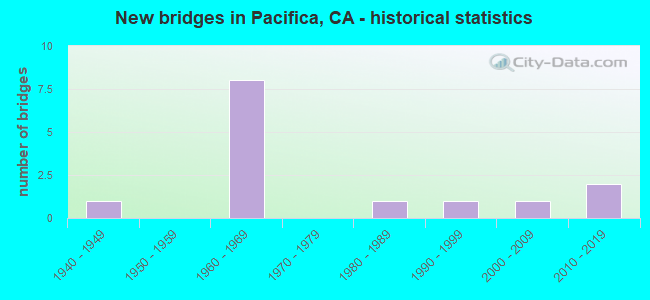
- New bridges - historical statistics
- 11940-1949
- 81960-1969
- 11980-1989
- 11990-1999
- 12000-2009
- 22010-2019


- Bridge Condition - Deck
- 50.0%Good
- 12.5%Satisfactory
- 37.5%Fair

- Bridge Condition - Superstructure
- 75.0%Good
- 25.0%Fair

- Bridge Condition - Channel
- 25.0%Excellent
- 25.0%Very good
- 50.0%Satisfactory
Find on map >> Show street view
Structure Number: 35 0021R, Location: 04-SM-001-R43.74-PFA (Lat: 37.629714, Lng: -122.489222), Route carried "on" structure: State highway 1, Year Built: 1965, Status: Open, Structure Length: 3.81m (12.50ft), Average Daily Traffic: 16,250 (year 2009), Truck Traffic: 3%, Average Future Daily Traffic: 24,514 (year 2037), Design Load: HS 20, Features Intersected: CLARENDON ROAD
Minimum Vertical Clearance: 30+ m (98+ ft), Kilometerpoint: 43.740, Lanes on structure: 2, Lanes under structure: 2, Base Highway Network: Yes (, Subroute: 1), Owner: State Highway Agency, Approaching Roadway Width: 11.3m (37.1ft), Material/Design: Concrete continuous, Design/Construction: Tee Beam, Number Of Spans In Main Unit: 3, Length of Maximum Span: 19.2m (63.0ft), Curb-To-Curb Width: 11.3m (37.1ft), Out-to-Out Width: 12.1m (39.7ft)
Condition: Deck: Fair, Superstructure: Good, Substructure: Good, Operating Rating: 80.7 metric tons, Method Used To Determine Operating Rating: Load Factor (LF), Inventory Rating: 48.6 metric tons, Method Used To Determine Inventory Rating: Load Factor (LF), Structural Evaluation: Better than present minimum criteria, Deck Geometry: Somewhat better than minimum adequacy, Underclear: Meets minimum limits, Approach Roadway Alignment: Equal to present desirable criteria, Designated Inspection Frequency: Every 24 months, Inspection Date: October 2020, Deck Structure Type: Concrete Cast-file-Place, Wearing Surface/Protective System: Wearing Surface: Integral Concrete
Find on map >> Show street view
Structure Number: 35 0025, Location: 04-SM-001-R45.12-PFA (Lat: 37.649222, Lng: -122.491069), Route carried "on" structure: City street D572, Year Built: 1965, Status: Open, Structure Length: 3.59m (11.78ft), Average Daily Traffic: 7,940 (year 2000), Truck Traffic: 2%, Average Future Daily Traffic: 16,917 (year 2037), Design Load: HS 20, Features Intersected: STATE ROUTE 1, Facility Carried by Structure: MANOR DRIVE
Minimum Vertical Clearance: 30+ m (98+ ft), Kilometerpoint: 0.000, Lanes on structure: 4, Lanes under structure: 4, Owner: State Highway Agency, Approaching Roadway Width: 14.6m (47.9ft), Material/Design: Concrete continuous, Design/Construction: Tee Beam, Number Of Spans In Main Unit: 2, Length of Maximum Span: 17.9m (58.7ft), Curb or Sidewalk Widths: Left: 1.6m (5.2ft), Right: 1.6m (5.2ft), Curb-To-Curb Width: 14.6m (47.9ft), Out-to-Out Width: 18.9m (62.0ft)
Condition: Deck: Fair, Superstructure: Good, Substructure: Good, Operating Rating: 34.3 metric tons, Method Used To Determine Operating Rating: Load and Resistance Factor Rating (LRFR) rating reported by rating factor(RF) method using HL-93 loadings, Inventory Rating: 24.6 metric tons, Method Used To Determine Inventory Rating: Load and Resistance Factor Rating (LRFR) rating reported by rating factor(RF) method using HL-93 loadings, Structural Evaluation: Equal to present minimum criteria, Deck Geometry: High priority of replacement, Underclear: Meets minimum limits, Approach Roadway Alignment: Equal to present desirable criteria, Designated Inspection Frequency: Every 24 months, Inspection Date: October 2020, Deck Structure Type: Concrete Cast-file-Place, Wearing Surface/Protective System: Wearing Surface: Epoxy Overlay
Find on map >> Show street view
Structure Number: 35 0180R, Location: 04-SM-001-R47.76-DLC (Lat: 37.677236, Lng: -122.471661), Route carried "on" structure: State highway 1, Year Built: 1967, Status: Open, Structure Length: 13.63m (44.72ft), Average Daily Traffic: 32,500 (year 2009), Truck Traffic: 2%, Average Future Daily Traffic: 48,210 (year 2037), Design Load: HS 20+Mod, Features Intersected: INTERSTATE 280
Minimum Vertical Clearance: 5.41m (17.75ft), Kilometerpoint: 47.760, Lanes on structure: 3, Lanes under structure: 9, Base Highway Network: Yes (, Subroute: 1), Owner: State Highway Agency, Approaching Roadway Width: 14.9m (48.9ft), Skew: 5 degrees, Material/Design: Concrete continuous, Design/Construction: Box Beam or Girders - Multiple, Number Of Spans In Main Unit: 4, Length of Maximum Span: 48.2m (158.1ft), Curb-To-Curb Width: 14.9m (48.9ft), Out-to-Out Width: 16.1m (52.8ft)
Condition: Deck: Good, Superstructure: Fair, Substructure: Good, Operating Rating: 97.8 metric tons, Method Used To Determine Operating Rating: Load Factor (LF), Inventory Rating: 58.6 metric tons, Method Used To Determine Inventory Rating: Load Factor (LF), Structural Evaluation: Somewhat better than minimum adequacy, Deck Geometry: Meets minimum limits, Underclear: High priority of corrective action, Approach Roadway Alignment: Equal to present minimum criteria, Designated Inspection Frequency: Every 24 months, Inspection Date: October 2020, Deck Structure Type: Concrete Cast-file-Place, Wearing Surface/Protective System: Wearing Surface: Integral Concrete
Find on map >> Show street view
Structure Number: 35 0187, Location: 04-SM-001-R44.21-PFA (Lat: 37.636425, Lng: -122.490172), Route carried "on" structure: City street , Year Built: 1965, Status: Open, Structure Length: 5.58m (18.31ft), Average Daily Traffic: 1,118 (year 2000), Truck Traffic: 3%, Average Future Daily Traffic: 2,663 (year 2037), Design Load: HS 20, Features Intersected: STATE ROUTE 1, Facility Carried by Structure: PALOMA AVENUE
Minimum Vertical Clearance: 30+ m (98+ ft), Kilometerpoint: 0.000, Lanes on structure: 2, Lanes under structure: 4, Owner: State Highway Agency, Approaching Roadway Width: 14.6m (47.9ft), Material/Design: Concrete continuous, Design/Construction: Tee Beam, Number Of Spans In Main Unit: 4, Length of Maximum Span: 17.9m (58.7ft), Curb or Sidewalk Widths: Left: 1.6m (5.2ft), Right: 1.6m (5.2ft), Curb-To-Curb Width: 14.6m (47.9ft), Out-to-Out Width: 18.9m (62.0ft)
Condition: Deck: Satisfactory, Superstructure: Good, Substructure: Good, Operating Rating: 32.1 metric tons, Method Used To Determine Operating Rating: Load and Resistance Factor Rating (LRFR) rating reported by rating factor(RF) method using HL-93 loadings, Inventory Rating: 22.7 metric tons, Method Used To Determine Inventory Rating: Load and Resistance Factor Rating (LRFR) rating reported by rating factor(RF) method using HL-93 loadings, Structural Evaluation: Equal to present minimum criteria, Deck Geometry: Superior to present desirable criteria, Underclear: High priority of corrective action, Approach Roadway Alignment: Equal to present desirable criteria, Designated Inspection Frequency: Every 24 months, Inspection Date: October 2020, Deck Structure Type: Concrete Cast-file-Place
Find on map >> Show street view
Structure Number: 35 0331R, Location: 04-SM-001-R39.93-PFA (Lat: 37.582672, Lng: -122.509447), Route carried "on" structure: State highway 1, Year Built: 2009, Status: Open, Structure Length: 27.54m (90.35ft), Average Daily Traffic: 14,500 (year 2009), Truck Traffic: 1%, Average Future Daily Traffic: 40,738 (year 2037), Design Load: HS 20, Features Intersected: DEVIL SLIDE
Minimum Vertical Clearance: 30+ m (98+ ft), Kilometerpoint: 39.930, Lanes on structure: 1, Base Highway Network: Yes (, Subroute: 1), Owner: State Highway Agency, Approaching Roadway Width: 7.8m (25.6ft), Material/Design: Prestressed concrete, Design/Construction: Segmental Box Girder, Number Of Spans In Main Unit: 3, Length of Maximum Span: 136.4m (447.5ft), Curb-To-Curb Width: 7.8m (25.6ft), Out-to-Out Width: 8.9m (29.2ft)
Condition: Deck: Good, Superstructure: Good, Substructure: Good, Operating Rating: 54.1 metric tons, Method Used To Determine Operating Rating: Assigned rating based on Load Factor Design (LFD) reported in metric tons, Inventory Rating: 32.4 metric tons, Method Used To Determine Inventory Rating: Assigned rating based on Load Factor Design (LFD) reported in metric tons, Structural Evaluation: Better than present minimum criteria, Deck Geometry: High priority of replacement, Approach Roadway Alignment: Equal to present desirable criteria, Designated Inspection Frequency: Every 24 months, Inspection Date: October 2020, Deck Structure Type: Concrete Cast-file-Place
Find on map >> Show street view
Structure Number: 35 035, Location: 04-SM-001-40.83 (Lat: 37.594694, Lng: -122.505139), Route carried "on" structure: State highway 1, Year Built: 2015, Status: Open, Structure Length: 4.27m (14.01ft), Average Daily Traffic: 14,500 (year 2009), Truck Traffic: 1%, Average Future Daily Traffic: 40,603 (year 2038), Design Load: HL 93, Features Intersected: SAN PEDRO CREEK
Minimum Vertical Clearance: 30+ m (98+ ft), Kilometerpoint: 40.830, Lanes on structure: 2, Base Highway Network: Yes (, Subroute: 1), Owner: State Highway Agency, Approaching Roadway Width: 14.4m (47.2ft), Skew: 3 degrees, Material/Design: Prestressed concrete continuous, Design/Construction: Slab, Number Of Spans In Main Unit: 2, Length of Maximum Span: 23.5m (77.1ft), Curb or Sidewalk Widths: Left: 0.0m, Right: 3.6m (11.8ft), Curb-To-Curb Width: 14.4m (47.2ft), Out-to-Out Width: 19.2m (63.0ft)
Condition: Deck: Good, Superstructure: Good, Substructure: Good, Channel: Very good, Operating Rating: 42.1 metric tons, Method Used To Determine Operating Rating: Assigned ratings based on Load and Resistance Factor Design (LRFD) reported by rating factor (RF) using HL93 loadings, Inventory Rating: 32.4 metric tons, Method Used To Determine Inventory Rating: Assigned ratings based on Load and Resistance Factor Design (LRFD) reported by rating factor (RF) using HL93 loadings, Structural Evaluation: Better than present minimum criteria, Deck Geometry: Superior to present desirable criteria, Waterway Adequacy: Better than present minimum criteria, Approach Roadway Alignment: Equal to present desirable criteria, Designated Inspection Frequency: Every 48 months, Inspection Date: October 2020, Deck Structure Type: Concrete Cast-file-Place, Wearing Surface/Protective System: Wearing Surface: Integral Concrete
Find on map >> Show street view
Structure Number: 35C0097, Location: 0.1 MI N LINDA MAR BLVD (Lat: 37.581483, Lng: -122.475581), Route carried "on" structure: City street , Year Built: 1948, Status: Open, Structure Length: 0.70m (2.30ft), Average Daily Traffic: 6,886 (year 2019), Truck Traffic: 2%, Average Future Daily Traffic: 5,015 (year 2041), Features Intersected: SOUTH FORK SAN PEDRO CRK, Facility Carried by Structure: ODDSTAD BLVD
Minimum Vertical Clearance: 30+ m (98+ ft), Kilometerpoint: 0.000, Lanes on structure: 3, Owner: City or Municipal Highway Agency, Approaching Roadway Width: 14.0m (45.9ft), Skew: 1 degrees, Material/Design: Concrete continuous, Design/Construction: Culvert, Number Of Spans In Main Unit: 2, Length of Maximum Span: 3.3m (10.8ft), Curb or Sidewalk Widths: Left: 2.0m (6.6ft), Right: 1.3m (4.3ft)
Condition: Channel: Satisfactory, Culverts: Satisfactory, Operating Rating: 27.2 metric tons, Method Used To Determine Operating Rating: Field evaluation and documented engineering judgment, Inventory Rating: 16.2 metric tons, Method Used To Determine Inventory Rating: Field evaluation and documented engineering judgment, Structural Evaluation: Meets minimum limits, Waterway Adequacy: Equal to present minimum criteria, Approach Roadway Alignment: Equal to present minimum criteria, Designated Inspection Frequency: Every 24 months, Inspection Date: May 2021
Find on map >> Show street view
Structure Number: 35C0142, Location: S. OF DELL RD (Lat: 37.588336, Lng: -122.499278), Route carried "on" structure: City street , Year Built: 1984, Status: Open, Structure Length: 1.45m (4.76ft), Average Daily Traffic: 2,389 (year 2019), Truck Traffic: 2%, Average Future Daily Traffic: 4,276 (year 2039), Design Load: HS 20+Mod, Features Intersected: SAN PEDRO CREEK, Facility Carried by Structure: PERALTA ROAD
Minimum Vertical Clearance: 30+ m (98+ ft), Kilometerpoint: 0.000, Lanes on structure: 2, Owner: City or Municipal Highway Agency, Approaching Roadway Width: 8.2m (26.9ft), Material/Design: Concrete, Design/Construction: Box Beam or Girders - Multiple, Number Of Spans In Main Unit: 1, Length of Maximum Span: 14.0m (45.9ft), Curb or Sidewalk Widths: Left: 1.5m (4.9ft), Right: 1.4m (4.6ft), Curb-To-Curb Width: 11.0m (36.1ft), Out-to-Out Width: 14.5m (47.6ft)
Condition: Deck: Good, Superstructure: Good, Substructure: Good, Channel: Satisfactory, Operating Rating: 82.9 metric tons, Method Used To Determine Operating Rating: Load Factor (LF), Inventory Rating: 49.9 metric tons, Method Used To Determine Inventory Rating: Load Factor (LF), Structural Evaluation: Better than present minimum criteria, Deck Geometry: Somewhat better than minimum adequacy, Waterway Adequacy: Better than present minimum criteria, Approach Roadway Alignment: Equal to present minimum criteria, Designated Inspection Frequency: Every 48 months, Inspection Date: May 2021, Deck Structure Type: Concrete Cast-file-Place
Find on map >> Show street view
Structure Number: 35C0156, Location: PACIFICA (Lat: 37.594939, Lng: -122.505311), Route carried "on" structure: Business City street , Year Built: 1996, Status: Open, Structure Length: 4.18m (13.71ft), Average Daily Traffic: 4,500 (year 2019), Truck Traffic: 5%, Average Future Daily Traffic: 5,118 (year 2039), Design Load: HS 20+Mod, Features Intersected: SAN PEDRO CREEK, Facility Carried by Structure: SAN PEDRO AVE
Minimum Vertical Clearance: 30+ m (98+ ft), Kilometerpoint: 0.000, Lanes on structure: 2, Owner: City or Municipal Highway Agency, Approaching Roadway Width: 9.1m (29.9ft), Skew: 3 degrees, Material/Design: Prestressed concrete continuous, Design/Construction: Slab, Number Of Spans In Main Unit: 2, Length of Maximum Span: 21.3m (69.9ft), Curb or Sidewalk Widths: Left: 1.8m (5.9ft), Right: 0.0m, Curb-To-Curb Width: 9.1m (29.9ft), Out-to-Out Width: 12.2m (40.0ft)
Condition: Deck: Fair, Superstructure: Fair, Substructure: Good, Channel: Excellent, Operating Rating: 54.1 metric tons, Method Used To Determine Operating Rating: Assigned rating based on Load Factor Design (LFD) reported in metric tons, Inventory Rating: 32.4 metric tons, Method Used To Determine Inventory Rating: Assigned rating based on Load Factor Design (LFD) reported in metric tons, Structural Evaluation: Somewhat better than minimum adequacy, Deck Geometry: Meets minimum limits, Waterway Adequacy: Meets minimum limits, Approach Roadway Alignment: Equal to present desirable criteria, Designated Inspection Frequency: Every 24 months, Inspection Date: May 2021, Deck Structure Type: Concrete Cast-file-Place
Find on map >> Show street view
Structure Number: 35 0025, Location: 04-SM-001-R45.12-PFA (Lat: 37.649222, Lng: -122.491069), Route carried "under" structure: State highway 1, Year Built: 1965, Structure Length: 0. m, Average Daily Traffic: 32,500 (year 2009), Truck Traffic: 3%, Features Intersected: STATE ROUTE 1, Facility Carried by Structure: MANOR DRIVE
Minimum Vertical Clearance: 5.05m (16.57ft), Kilometerpoint: 45.120, Lanes on structure: 4, Lanes under structure: 4, Material/Design: Concrete continuous, Design/Construction: Tee Beam, Length of Maximum Span: 17.9m (58.7ft)
Find on map >> Show street view
Structure Number: 35 017, Location: 04-SM-001-R43.46-PFA (Lat: 37.625758, Lng: -122.487969), Route carried "under" structure: State highway 1, Year Built: 1965, Structure Length: 0. m, Average Daily Traffic: 32,500 (year 2009), Truck Traffic: 3%, Features Intersected: STATE ROUTE 1, Facility Carried by Structure: SHARP PARK ROAD
Minimum Vertical Clearance: 4.80m (15.75ft), Kilometerpoint: 43.460, Lanes on structure: 2, Lanes under structure: 6, Material/Design: Concrete continuous, Design/Construction: Box Beam or Girders - Multiple, Length of Maximum Span: 32.0m (105.0ft)
Find on map >> Show street view
Structure Number: 35 0187, Location: 04-SM-001-R44.21-PFA (Lat: 37.636425, Lng: -122.490172), Route carried "under" structure: State highway 1, Year Built: 1965, Structure Length: 0. m, Average Daily Traffic: 32,500 (year 2009), Truck Traffic: 3%, Features Intersected: STATE ROUTE 1, Facility Carried by Structure: PALOMA AVENUE
Minimum Vertical Clearance: 4.57m (14.99ft), Kilometerpoint: 44.210, Lanes on structure: 2, Lanes under structure: 4, Material/Design: Concrete continuous, Design/Construction: Tee Beam, Length of Maximum Span: 17.9m (58.7ft)
Find on map >> Show street view
Structure Number: 35 0188, Location: 04-SM-001-R44.88-PFA (Lat: 37.645506, Lng: -122.492181), Route carried "under" structure: State highway 1, Year Built: 1965, Structure Length: 0. m, Average Daily Traffic: 32,500 (year 2009), Truck Traffic: 3%, Features Intersected: STATE ROUTE 1, Facility Carried by Structure: PEDESTRIAN WALKWAY
Minimum Vertical Clearance: 5.31m (17.42ft), Kilometerpoint: 44.880, Lanes under structure: 7, Material/Design: Concrete continuous, Design/Construction: Box Beam or Girders - Multiple, Length of Maximum Span: 28.0m (91.9ft)
Find on map >> Show street view
Structure Number: 35 0356, Location: 04-SM-001-R44.07-PFA (Lat: 37.634319, Lng: -122.489786), Route carried "under" structure: State highway 1, Year Built: 2019, Structure Length: 0. m, Average Daily Traffic: 32,500 (year 2009), Truck Traffic: 3%, Features Intersected: STATE ROUTE 1, Facility Carried by Structure: PEDESTRIAN WALKWAY
Minimum Vertical Clearance: 5.69m (18.67ft), Kilometerpoint: 44.070, Lanes under structure: 4, Material/Design: Concrete continuous, Design/Construction: Box Beam or Girders - Single/Spread, Length of Maximum Span: 26.7m (87.6ft)