Bridge Statistics for Palermo, California (CA)
Condition, Traffic, Stress, Structural Evaluation, Project Costs
- National Bridge Inventory (NBI) Statistics
- 15Number of bridges
- 89ft / 27.0mTotal length
- $414,000Total costs
- 44,262Total average daily traffic
- 2,598Total average daily truck traffic
- 62,967Total future (year 2039) average daily traffic
- National Bridge Inventory (NBI) Registered Bridges for Palermo
- No street view available for this location
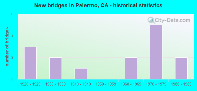
- New bridges - historical statistics
- 31920-1929
- 21930-1939
- 11940-1949
- 21960-1969
- 51970-1979
- 21980-1989

- Reconstructed bridges - Historical Statistics
- 11930-1939
- 11940-1949


- Bridge Condition - Deck
- 76.9%Good
- 23.1%Fair

- Bridge Condition - Superstructure
- 64.3%Good
- 7.1%Satisfactory
- 21.4%Fair
- 7.1%Poor

- Bridge Condition - Substructure
- 78.6%Good
- 21.4%Fair

- Bridge Condition - Channel
- 6.7%Excellent
- 26.7%Very good
- 33.3%Good
- 33.3%Satisfactory
Find on map >> Show street view
Structure Number: 12 0061, Location: 03-BUT-070-8.34 (Lat: 39.423175, Lng: -121.605039), Route carried "on" structure: State highway 70, Year Built: 1922, Year Reconstructed: 1951, Status: Open, Structure Length: 0.67m (2.20ft), Average Daily Traffic: 11,400 (year 2009), Average Future Daily Traffic: 20,294 (year 2039), Features Intersected: OAK KNOB DRAW
Minimum Vertical Clearance: 30+ m (98+ ft), Kilometerpoint: 8.340, Lanes on structure: 2, Base Highway Network: Yes (, Subroute: 1), Owner: State Highway Agency, Approaching Roadway Width: 12.5m (41.0ft), Material/Design: Concrete continuous, Design/Construction: Culvert, Number Of Spans In Main Unit: 2, Length of Maximum Span: 3.1m (10.2ft), Curb-To-Curb Width: 12.5m (41.0ft), Out-to-Out Width: 13.6m (44.6ft)
Condition: Channel: Very good, Culverts: Good, Operating Rating: 34.7 metric tons, Method Used To Determine Operating Rating: Load Factor (LF), Inventory Rating: 20.7 metric tons, Method Used To Determine Inventory Rating: Load Factor (LF), Structural Evaluation: Somewhat better than minimum adequacy, Deck Geometry: Somewhat better than minimum adequacy, Waterway Adequacy: Equal to present minimum criteria, Approach Roadway Alignment: Equal to present desirable criteria, Designated Inspection Frequency: Every 24 months, Inspection Date: August 2021, Deck Structure Type: Concrete Cast-file-Place, Wearing Surface/Protective System: Wearing Surface: Bituminous
Find on map >> Show street view
Structure Number: 12C0117, Location: 1.0 MI N WELSH RD (Lat: 39.446919, Lng: -121.606067), Route carried "on" structure: County highway , Year Built: 1922, Year Reconstructed: 1930, Status: Open, Structure Length: 0.79m (2.59ft), Average Daily Traffic: 230 (year 2019), Truck Traffic: 13%, Average Future Daily Traffic: 267 (year 2041), Features Intersected: DREDGER GULCH, Facility Carried by Structure: PACIFIC HEIGHTS RD
Minimum Vertical Clearance: 30+ m (98+ ft), Kilometerpoint: 0.000, Lanes on structure: 2, Owner: County Highway Agency, Approaching Roadway Width: 6.1m (20.0ft), Skew: 2 degrees, Material/Design: Concrete continuous, Design/Construction: Slab, Number Of Spans In Main Unit: 2, Length of Maximum Span: 4.0m (13.1ft), Curb-To-Curb Width: 8.0m (26.2ft), Out-to-Out Width: 8.4m (27.6ft)
Condition: Deck: Good, Superstructure: Fair, Substructure: Good, Channel: Good, Operating Rating: 24.0 metric tons, Method Used To Determine Operating Rating: Field evaluation and documented engineering judgment, Inventory Rating: 14.3 metric tons, Method Used To Determine Inventory Rating: Field evaluation and documented engineering judgment, Structural Evaluation: Meets minimum limits, Deck Geometry: Somewhat better than minimum adequacy, Waterway Adequacy: Superior to present desirable criteria, Approach Roadway Alignment: Equal to present desirable criteria, Designated Inspection Frequency: Every 24 months, Inspection Date: May 2021, Deck Structure Type: Concrete Cast-file-Place, Wearing Surface/Protective System: Wearing Surface: Bituminous
Find on map >> Show street view
Structure Number: 12C0128, Location: 0.6 MI N OF COX LANE (Lat: 39.393292, Lng: -121.539850), Route carried "on" structure: County highway , Year Built: 1963, Status: Open, Structure Length: 3.08m (10.10ft), Average Daily Traffic: 1,611 (year 2019), Truck Traffic: 25%, Average Future Daily Traffic: 1,257 (year 2039), Design Load: HS 20, Features Intersected: WYANDOTTE CREEK, Facility Carried by Structure: PALERMO-HONCUT HWY
Minimum Vertical Clearance: 30+ m (98+ ft), Kilometerpoint: 0.000, Lanes on structure: 2, Owner: County Highway Agency, Approaching Roadway Width: 7.3m (24.0ft), Material/Design: Concrete continuous, Design/Construction: Slab, Number Of Spans In Main Unit: 4, Length of Maximum Span: 8.5m (27.9ft), Curb-To-Curb Width: 9.8m (32.2ft), Out-to-Out Width: 9.9m (32.5ft)
Condition: Deck: Good, Superstructure: Good, Substructure: Fair, Channel: Very good, Operating Rating: 64.2 metric tons, Method Used To Determine Operating Rating: Load Factor (LF), Inventory Rating: 38.6 metric tons, Method Used To Determine Inventory Rating: Load Factor (LF), Structural Evaluation: Somewhat better than minimum adequacy, Deck Geometry: Somewhat better than minimum adequacy, Waterway Adequacy: Equal to present desirable criteria, Approach Roadway Alignment: Equal to present minimum criteria, Designated Inspection Frequency: Every 24 months, Inspection Date: August 2021, Deck Structure Type: Concrete Cast-file-Place, Wearing Surface/Protective System: Wearing Surface: Bituminous
Find on map >> Show street view
Structure Number: 12C0138, Location: 0.5 MI E LONE TREE RD (Lat: 39.386672, Lng: -121.566633), Route carried "on" structure: County highway , Year Built: 1966, Status: Open, Structure Length: 2.44m (8.01ft), Average Daily Traffic: 418 (year 2019), Truck Traffic: 15%, Average Future Daily Traffic: 367 (year 2041), Design Load: HS 20, Features Intersected: WYANDOTTE CREEK, Facility Carried by Structure: COX LANE
Minimum Vertical Clearance: 30+ m (98+ ft), Kilometerpoint: 0.000, Lanes on structure: 2, Owner: County Highway Agency, Approaching Roadway Width: 7.3m (24.0ft), Skew: 2 degrees, Material/Design: Concrete continuous, Design/Construction: Slab, Number Of Spans In Main Unit: 3, Length of Maximum Span: 7.9m (25.9ft), Curb-To-Curb Width: 7.9m (25.9ft), Out-to-Out Width: 8.1m (26.6ft)
Condition: Deck: Good, Superstructure: Good, Substructure: Good, Channel: Good, Operating Rating: 25.6 metric tons, Method Used To Determine Operating Rating: Load and Resistance Factor Rating (LRFR) rating reported by rating factor(RF) method using HL-93 loadings, Inventory Rating: 19.8 metric tons, Method Used To Determine Inventory Rating: Load and Resistance Factor Rating (LRFR) rating reported by rating factor(RF) method using HL-93 loadings, Structural Evaluation: Somewhat better than minimum adequacy, Deck Geometry: Somewhat better than minimum adequacy, Waterway Adequacy: Equal to present desirable criteria, Approach Roadway Alignment: Equal to present desirable criteria, Designated Inspection Frequency: Every 24 months, Inspection Date: July 2021, Deck Structure Type: Concrete Cast-file-Place, Wearing Surface/Protective System: Wearing Surface: Bituminous
Find on map >> Show street view
Structure Number: 12C0139, Location: 0.6 MI S PALERMO RD (Lat: 39.427506, Lng: -121.537333), Route carried "on" structure: County highway , Year Built: 1974, Status: Open, Structure Length: 1.40m (4.59ft), Average Daily Traffic: 2,423 (year 2018), Truck Traffic: 13%, Average Future Daily Traffic: 1,891 (year 2043), Design Load: HS 20, Features Intersected: BRANCH WYMAN RAVINE, Facility Carried by Structure: PALERMO-HONCUT HWY
Minimum Vertical Clearance: 30+ m (98+ ft), Kilometerpoint: 0.000, Lanes on structure: 2, Owner: County Highway Agency, Approaching Roadway Width: 7.3m (24.0ft), Skew: 3 degrees, Material/Design: Concrete continuous, Design/Construction: Slab, Number Of Spans In Main Unit: 2, Length of Maximum Span: 6.7m (22.0ft), Curb-To-Curb Width: 9.8m (32.2ft), Out-to-Out Width: 10.0m (32.8ft)
Condition: Deck: Good, Superstructure: Good, Substructure: Good, Channel: Satisfactory, Operating Rating: 56.4 metric tons, Method Used To Determine Operating Rating: Load Factor (LF), Inventory Rating: 34.0 metric tons, Method Used To Determine Inventory Rating: Load Factor (LF), Structural Evaluation: Better than present minimum criteria, Deck Geometry: Meets minimum limits, Waterway Adequacy: Equal to present desirable criteria, Approach Roadway Alignment: Equal to present minimum criteria, Designated Inspection Frequency: Every 24 months, Inspection Date: May 2021, Deck Structure Type: Concrete Cast-file-Place, Wearing Surface/Protective System: Wearing Surface: Bituminous
Find on map >> Show street view
Structure Number: 12C014, Location: 0.2 MI NE PINECREST RD (Lat: 39.461392, Lng: -121.528986), Route carried "on" structure: County highway , Year Built: 1975, Status: Open, Structure Length: 1.25m (4.10ft), Average Daily Traffic: 3,909 (year 2017), Truck Traffic: 8%, Average Future Daily Traffic: 3,207 (year 2041), Design Load: HS 20, Features Intersected: BRANCH WYMAN RAVINE, Facility Carried by Structure: UPPER PALERMO ROAD
Minimum Vertical Clearance: 30+ m (98+ ft), Kilometerpoint: 0.000, Lanes on structure: 2, Owner: County Highway Agency, Approaching Roadway Width: 8.5m (27.9ft), Skew: 1 degrees, Material/Design: Concrete continuous, Design/Construction: Slab, Number Of Spans In Main Unit: 2, Length of Maximum Span: 6.1m (20.0ft), Curb-To-Curb Width: 9.8m (32.2ft), Out-to-Out Width: 10.0m (32.8ft)
Condition: Deck: Fair, Superstructure: Fair, Substructure: Good, Channel: Satisfactory, Operating Rating: 81.0 metric tons, Method Used To Determine Operating Rating: Load Factor (LF), Inventory Rating: 48.6 metric tons, Method Used To Determine Inventory Rating: Load Factor (LF), Structural Evaluation: Somewhat better than minimum adequacy, Deck Geometry: Meets minimum limits, Waterway Adequacy: Equal to present minimum criteria, Approach Roadway Alignment: Equal to present desirable criteria, Designated Inspection Frequency: Every 24 months, Inspection Date: May 2021, Deck Structure Type: Concrete Cast-file-Place
Find on map >> Show street view
Structure Number: 12C0223, Location: 0.2 MI E OF SH70 (Lat: 39.364786, Lng: -121.602642), Route carried "on" structure: County highway , Year Built: 1935, Status: Open, Structure Length: 0.94m (3.08ft), Average Daily Traffic: 500 (year 2019), Truck Traffic: 15%, Average Future Daily Traffic: 734 (year 2041), Features Intersected: WYMAN RAVINE, Facility Carried by Structure: STIMPSON RD
Minimum Vertical Clearance: 30+ m (98+ ft), Kilometerpoint: 0.000, Lanes on structure: 2, Owner: County Highway Agency, Approaching Roadway Width: 6.7m (22.0ft), Skew: 1 degrees, Material/Design: Concrete, Design/Construction: Tee Beam, Number Of Spans In Main Unit: 1, Length of Maximum Span: 9.2m (30.2ft), Curb-To-Curb Width: 6.6m (21.7ft), Out-to-Out Width: 7.2m (23.6ft)
Condition: Deck: Good, Superstructure: Good, Substructure: Fair, Channel: Good, Operating Rating: 25.9 metric tons, Method Used To Determine Operating Rating: Field evaluation and documented engineering judgment, Inventory Rating: 15.6 metric tons, Method Used To Determine Inventory Rating: Field evaluation and documented engineering judgment, Structural Evaluation: Meets minimum limits, Deck Geometry: High priority of corrective action, Waterway Adequacy: Equal to present desirable criteria, Approach Roadway Alignment: Equal to present desirable criteria, Designated Inspection Frequency: Every 24 months, Inspection Date: July 2021, Deck Structure Type: Concrete Cast-file-Place, Wearing Surface/Protective System: Wearing Surface: Bituminous
Find on map >> Show street view
Structure Number: 12C0264, Location: JUST N OF AVACADO ROAD (Lat: 39.405975, Lng: -121.455261), Route carried "on" structure: County highway , Year Built: 1930, Status: Posted for load, Structure Length: 2.94m (9.65ft), Average Daily Traffic: 132 (year 2017), Truck Traffic: 12%, Average Future Daily Traffic: 262 (year 2039), Features Intersected: NORTH FORK HONCUT CREEK, Facility Carried by Structure: DUNSTONE ROAD
Minimum Vertical Clearance: 30+ m (98+ ft), Kilometerpoint: 0.000, Lanes on structure: 2, Owner: County Highway Agency, Approaching Roadway Width: 4.9m (16.1ft), Material/Design: Concrete, Design/Construction: Arch - Deck, Number Of Spans In Main Unit: 2, Length of Maximum Span: 21.4m (70.2ft), Curb-To-Curb Width: 5.5m (18.0ft), Out-to-Out Width: 6.1m (20.0ft)
Condition: Deck: Fair, Superstructure: Good, Substructure: Good, Channel: Good, Operating Rating: 14.9 metric tons, Method Used To Determine Operating Rating: Load Factor (LF), Inventory Rating: 9.1 metric tons, Method Used To Determine Inventory Rating: Load Factor (LF), Structural Evaluation: High priority of corrective action, Deck Geometry: High priority of corrective action, Waterway Adequacy: Superior to present desirable criteria, Approach Roadway Alignment: Equal to present desirable criteria, Bridge Posting: Required (Relationship of Operating Rating to Maximum Legal Load: 20.0 - 29.9% below), Designated Inspection Frequency: Every 24 months, Inspection Date: August 2021, Deck Structure Type: Concrete Cast-file-Place, Wearing Surface/Protective System: Wearing Surface: Bituminous
Find on map >> Show street view
Structure Number: 12C0288, Location: 0.9 MI N PALERMO RD (Lat: 39.447783, Lng: -121.551683), Route carried "on" structure: County highway , Year Built: 1974, Status: Open, Structure Length: 3.02m (9.91ft), Average Daily Traffic: 3,200 (year 2006), Truck Traffic: 6%, Average Future Daily Traffic: 6,413 (year 2041), Design Load: HS 20, Features Intersected: WYMAN RAVINE, Facility Carried by Structure: LINCOLN BLVD
Minimum Vertical Clearance: 30+ m (98+ ft), Kilometerpoint: 0.000, Lanes on structure: 2, Owner: County Highway Agency, Approaching Roadway Width: 7.3m (24.0ft), Skew: 3 degrees, Material/Design: Concrete continuous, Design/Construction: Slab, Number Of Spans In Main Unit: 4, Length of Maximum Span: 8.5m (27.9ft), Curb-To-Curb Width: 9.8m (32.2ft), Out-to-Out Width: 10.0m (32.8ft)
Condition: Deck: Good, Superstructure: Good, Substructure: Good, Channel: Satisfactory, Operating Rating: 95.6 metric tons, Method Used To Determine Operating Rating: Load Factor (LF), Inventory Rating: 57.3 metric tons, Method Used To Determine Inventory Rating: Load Factor (LF), Structural Evaluation: Better than present minimum criteria, Deck Geometry: Meets minimum limits, Waterway Adequacy: Equal to present desirable criteria, Approach Roadway Alignment: Equal to present desirable criteria, Designated Inspection Frequency: Every 48 months, Inspection Date: May 2019, Deck Structure Type: Concrete Cast-file-Place
Find on map >> Show street view
Structure Number: 12C0293, Location: 5.3 MI N/O LA PORTE RD (Lat: 39.456989, Lng: -121.443067), Route carried "on" structure: County highway , Year Built: 1920, Status: Open, Structure Length: 1.01m (3.31ft), Average Daily Traffic: 1,279 (year 2017), Truck Traffic: 16%, Average Future Daily Traffic: 2,095 (year 2039), Features Intersected: N FK HONCUT CREEK, Facility Carried by Structure: BANGOR HWY
Minimum Vertical Clearance: 30+ m (98+ ft), Kilometerpoint: 0.000, Lanes on structure: 2, Owner: County Highway Agency, Approaching Roadway Width: 6.4m (21.0ft), Material/Design: Concrete, Design/Construction: Arch - Deck, Number Of Spans In Main Unit: 1, Length of Maximum Span: 9.6m (31.5ft), Curb or Sidewalk Widths: Left: 0.3m (1.0ft), Right: 0.3m (1.0ft), Curb-To-Curb Width: 7.2m (23.6ft), Out-to-Out Width: 8.0m (26.2ft)
Condition: Superstructure: Satisfactory, Substructure: Good, Channel: Good, Operating Rating: 25.9 metric tons, Method Used To Determine Operating Rating: Field evaluation and documented engineering judgment, Inventory Rating: 15.6 metric tons, Method Used To Determine Inventory Rating: Field evaluation and documented engineering judgment, Structural Evaluation: Meets minimum limits, Deck Geometry: High priority of corrective action, Waterway Adequacy: Superior to present desirable criteria, Approach Roadway Alignment: Equal to present desirable criteria, Designated Inspection Frequency: Every 24 months, Inspection Date: August 2021
Find on map >> Show street view
Structure Number: 12C0343, Location: 0.9 MI S LAS PLUMAS AVE (Lat: 39.470044, Lng: -121.529061), Route carried "on" structure: County highway , Year Built: 1972, Status: Open, Structure Length: 1.65m (5.41ft), Average Daily Traffic: 7,160 (year 2019), Truck Traffic: 5%, Average Future Daily Traffic: 12,074 (year 2043), Design Load: HS 20, Features Intersected: WYMAN RAVINE, Facility Carried by Structure: LOWER WYANDOTTE RD
Minimum Vertical Clearance: 30+ m (98+ ft), Kilometerpoint: 0.000, Lanes on structure: 2, Owner: County Highway Agency, Approaching Roadway Width: 8.5m (27.9ft), Material/Design: Concrete continuous, Design/Construction: Slab, Number Of Spans In Main Unit: 2, Length of Maximum Span: 7.9m (25.9ft), Curb-To-Curb Width: 9.8m (32.2ft), Out-to-Out Width: 10.0m (32.8ft)
Condition: Deck: Good, Superstructure: Good, Substructure: Good, Channel: Satisfactory, Operating Rating: 53.5 metric tons, Method Used To Determine Operating Rating: Load and Resistance Factor Rating (LRFR) rating reported by rating factor(RF) method using HL-93 loadings, Inventory Rating: 41.1 metric tons, Method Used To Determine Inventory Rating: Load and Resistance Factor Rating (LRFR) rating reported by rating factor(RF) method using HL-93 loadings, Structural Evaluation: Better than present minimum criteria, Deck Geometry: Meets minimum limits, Waterway Adequacy: Equal to present desirable criteria, Approach Roadway Alignment: Equal to present desirable criteria, Designated Inspection Frequency: Every 48 months, Inspection Date: March 2021, Deck Structure Type: Concrete Cast-file-Place, Wearing Surface/Protective System: Wearing Surface: Bituminous
Find on map >> Show street view
Structure Number: 12C0344, Location: 1 MI S LAS PLUMAS AVE (Lat: 39.468347, Lng: -121.527125), Route carried "on" structure: County highway , Year Built: 1940, Status: Posted for load, Structure Length: 0.91m (2.99ft), Average Daily Traffic: 7,160 (year 2019), Truck Traffic: 2%, Average Future Daily Traffic: 11,757 (year 2041), Design Load: HS 20, Features Intersected: BRANCH WYMAN RAVINE, Facility Carried by Structure: LOWER WYANDOTTE RD
Minimum Vertical Clearance: 30+ m (98+ ft), Kilometerpoint: 0.000, Lanes on structure: 2, Owner: County Highway Agency, Approaching Roadway Width: 7.3m (24.0ft), Material/Design: Steel, Design/Construction: Stringer/Multi-beam, Number Of Spans In Main Unit: 2, Length of Maximum Span: 4.6m (15.1ft), Curb or Sidewalk Widths: Left: 0.2m (0.7ft), Right: 0.2m (0.7ft), Curb-To-Curb Width: 7.3m (24.0ft), Out-to-Out Width: 7.9m (25.9ft)
Condition: Deck: Good, Superstructure: Good, Substructure: Fair, Channel: Satisfactory, Operating Rating: 18.1 metric tons, Method Used To Determine Operating Rating: Load Factor (LF), Inventory Rating: 11.0 metric tons, Method Used To Determine Inventory Rating: Load Factor (LF), Structural Evaluation: High priority of corrective action, Deck Geometry: High priority of replacement, Waterway Adequacy: Equal to present minimum criteria, Approach Roadway Alignment: Equal to present desirable criteria, Bridge Posting: Required (Relationship of Operating Rating to Maximum Legal Load: 20.0 - 29.9% below), Designated Inspection Frequency: Every 24 months, Inspection Date: March 2021, Deck Structure Type: Concrete Cast-file-Place, Wearing Surface/Protective System: Wearing Surface: Bituminous
Find on map >> Show street view
Structure Number: 12C0357, Location: BTWN GENE LN & WYMAN AVE (Lat: 39.434478, Lng: -121.566975), Route carried "on" structure: County highway , Year Built: 1970, Status: Open, Structure Length: 2.50m (8.20ft), Average Daily Traffic: 250 (year 2007), Truck Traffic: 10%, Average Future Daily Traffic: 267 (year 2041), Design Load: HS 20, Features Intersected: WYMAN RAVINE, Facility Carried by Structure: PALERMO ROAD
Minimum Vertical Clearance: 30+ m (98+ ft), Kilometerpoint: 0.000, Lanes on structure: 2, Owner: County Highway Agency, Approaching Roadway Width: 9.1m (29.9ft), Material/Design: Prestressed concrete, Design/Construction: Box Beam or Girders - Multiple, Number Of Spans In Main Unit: 3, Length of Maximum Span: 8.2m (26.9ft), Curb-To-Curb Width: 9.7m (31.8ft), Out-to-Out Width: 9.9m (32.5ft)
Condition: Deck: Good, Superstructure: Poor, Substructure: Good, Channel: Very good, Operating Rating: 99.8 metric tons, Method Used To Determine Operating Rating: Load Factor (LF), Inventory Rating: 32.4 metric tons, Method Used To Determine Inventory Rating: Load Factor (LF), Structural Evaluation: Meets minimum limits, Deck Geometry: Equal to present minimum criteria, Waterway Adequacy: Equal to present desirable criteria, Approach Roadway Alignment: Equal to present desirable criteria, Length Of Structure Improvement: 2.50m (8.20ft), Designated Inspection Frequency: Every 24 months, Inspection Date: May 2021, Bridge Improvement Cost: $247,000, Roadway Improvement Cost: $49,000, Total Project Cost: $414,000 ( Estimate for 2020), Deck Structure Type: Concrete Precast Panels, Wearing Surface/Protective System: Wearing Surface: Bituminous
Find on map >> Show street view
Structure Number: 12C0358, Location: 0.4 MI E OF SH 70 (Lat: 39.382578, Lng: -121.604542), Route carried "on" structure: County highway , Year Built: 1989, Status: Open, Structure Length: 2.68m (8.79ft), Average Daily Traffic: 300 (year 2019), Truck Traffic: 27%, Average Future Daily Traffic: 265 (year 2041), Design Load: HS 20+Mod, Features Intersected: WYMAN RAVINE, Facility Carried by Structure: COX LANE
Minimum Vertical Clearance: 30+ m (98+ ft), Kilometerpoint: 0.000, Lanes on structure: 2, Owner: County Highway Agency, Approaching Roadway Width: 8.8m (28.9ft), Material/Design: Concrete continuous, Design/Construction: Slab, Number Of Spans In Main Unit: 3, Length of Maximum Span: 10.4m (34.1ft), Curb-To-Curb Width: 8.5m (27.9ft), Out-to-Out Width: 8.7m (28.5ft)
Condition: Deck: Fair, Superstructure: Fair, Substructure: Good, Channel: Very good, Operating Rating: 54.1 metric tons, Method Used To Determine Operating Rating: Assigned rating based on Load Factor Design (LFD) reported in metric tons, Inventory Rating: 32.4 metric tons, Method Used To Determine Inventory Rating: Assigned rating based on Load Factor Design (LFD) reported in metric tons, Structural Evaluation: Somewhat better than minimum adequacy, Deck Geometry: Equal to present minimum criteria, Waterway Adequacy: Equal to present desirable criteria, Approach Roadway Alignment: Equal to present desirable criteria, Designated Inspection Frequency: Every 24 months, Inspection Date: July 2021, Deck Structure Type: Concrete Cast-file-Place
Find on map >> Show street view
Structure Number: 12C0406, Location: 0.8 MI E LINCOLN BLVD (Lat: 39.465953, Lng: -121.534167), Route carried "on" structure: County highway , Year Built: 1988, Status: Open, Structure Length: 1.74m (5.71ft), Average Daily Traffic: 4,290 (year 2007), Truck Traffic: 9%, Average Future Daily Traffic: 1,817 (year 2041), Design Load: HS 20, Features Intersected: WYMAN RAVINE, Facility Carried by Structure: OPHIR RD EXTENSION
Minimum Vertical Clearance: 30+ m (98+ ft), Kilometerpoint: 0.000, Lanes on structure: 2, Owner: County Highway Agency, Approaching Roadway Width: 11.3m (37.1ft), Skew: 2 degrees, Material/Design: Concrete, Design/Construction: Box Beam or Girders - Multiple, Number Of Spans In Main Unit: 1, Length of Maximum Span: 17.1m (56.1ft), Curb-To-Curb Width: 12.2m (40.0ft), Out-to-Out Width: 12.4m (40.7ft)
Condition: Deck: Good, Superstructure: Good, Substructure: Good, Channel: Excellent, Operating Rating: 54.1 metric tons, Method Used To Determine Operating Rating: Assigned rating based on Load Factor Design (LFD) reported in metric tons, Inventory Rating: 32.4 metric tons, Method Used To Determine Inventory Rating: Assigned rating based on Load Factor Design (LFD) reported in metric tons, Structural Evaluation: Better than present minimum criteria, Deck Geometry: Equal to present minimum criteria, Waterway Adequacy: Superior to present desirable criteria, Approach Roadway Alignment: Equal to present desirable criteria, Designated Inspection Frequency: Every 48 months, Inspection Date: May 2019, Deck Structure Type: Concrete Cast-file-Place