Bridge Statistics for Pembroke Pines, Florida (FL)
Condition, Traffic, Stress, Structural Evaluation, Project Costs
- National Bridge Inventory (NBI) Statistics
- 21Number of bridges
- 213ft / 64.8mTotal length
- 932,780Total average daily traffic
- 89,789Total average daily truck traffic
- National Bridge Inventory (NBI) Registered Bridges for Pembroke Pines
- No street view available for this location
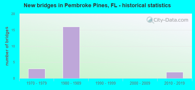
- New bridges - historical statistics
- 31970-1979
- 161980-1989
- 22010-2019


- Bridge Condition - Deck
- 22.2%Very good
- 66.7%Good
- 11.1%Satisfactory

- Bridge Condition - Superstructure
- 11.1%Very good
- 88.9%Good

- Bridge Condition - Substructure
- 55.6%Very good
- 44.4%Good
Find on map >> Show street view
Structure Number: 860329, Location: 2.4 Mi W of SR-823 (Lat: 26.029486, Lng: -80.351722), Route carried "on" structure: City street , Year Built: 1981, Year Reconstructed: 2017, Status: Open, Structure Length: 12.28m (40.29ft), Average Daily Traffic: 51,500 (year 2020), Truck Traffic: 6%, Average Future Daily Traffic: 89,352 (year 2042), Design Load: HS 20, Features Intersected: I-75 (SR-93), Facility Carried by Structure: SHERIDAN ST
Minimum Vertical Clearance: 30+ m (98+ ft), Kilometerpoint: 8.097, Lanes on structure: 11, Lanes under structure: 14, Owner: State Highway Agency, Approaching Roadway Width: 48.3m (158.5ft), Skew: 21 degrees, Material/Design: Prestressed concrete, Design/Construction: Stringer/Multi-beam, Number Of Spans In Main Unit: 5, Length of Maximum Span: 35.7m (117.1ft), Curb or Sidewalk Widths: Left: 2.4m (7.9ft), Right: 2.4m (7.9ft), Curb-To-Curb Width: 49.7m (163.1ft), Out-to-Out Width: 51.6m (169.3ft)
Condition: Deck: Good, Superstructure: Good, Substructure: Very good, Operating Rating: 55.2 metric tons, Method Used To Determine Operating Rating: Load Factor (LF), Inventory Rating: 33.0 metric tons, Method Used To Determine Inventory Rating: Load Factor (LF), Structural Evaluation: Better than present minimum criteria, Deck Geometry: Superior to present desirable criteria, Underclear: High priority of corrective action, Approach Roadway Alignment: Equal to present desirable criteria, Designated Inspection Frequency: Every 24 months, Inspection Date: September 2020, Deck Structure Type: Concrete Cast-file-Place
Find on map >> Show street view
Structure Number: 86035, Location: SR-820 AT I-75 (Lat: 26.007708, Lng: -80.340306), Route carried "on" structure: State highway 820, Year Built: 1982, Status: Open, Structure Length: 12.84m (42.13ft), Average Daily Traffic: 56,000 (year 2020), Truck Traffic: 6%, Average Future Daily Traffic: 97,160 (year 2042), Design Load: HS 20, Features Intersected: I-75 (SR-93)
Minimum Vertical Clearance: 30+ m (98+ ft), Kilometerpoint: 9.164, Lanes on structure: 6, Lanes under structure: 14, Base Highway Network: Yes, Owner: State Highway Agency, Approaching Roadway Width: 27.4m (89.9ft), Skew: 21 degrees, Material/Design: Prestressed concrete, Design/Construction: Stringer/Multi-beam, Number Of Spans In Main Unit: 5, Length of Maximum Span: 36.4m (119.4ft), Curb or Sidewalk Widths: Left: 2.0m (6.6ft), Right: 2.0m (6.6ft), Curb-To-Curb Width: 27.4m (89.9ft), Out-to-Out Width: 40.8m (133.9ft)
Condition: Deck: Satisfactory, Superstructure: Good, Substructure: Good, Operating Rating: 46.9 metric tons, Method Used To Determine Operating Rating: Load Factor (LF), Inventory Rating: 36.0 metric tons, Method Used To Determine Inventory Rating: Load Factor (LF), Structural Evaluation: Better than present minimum criteria, Deck Geometry: Better than present minimum criteria, Underclear: High priority of corrective action, Approach Roadway Alignment: Equal to present desirable criteria, Designated Inspection Frequency: Every 24 months, Inspection Date: September 2020, Deck Structure Type: Concrete Precast Panels
Find on map >> Show street view
Structure Number: 860407, Location: 2.9 MI N OF DADE CO. LINE (Lat: 26.009939, Lng: -80.213292), Route carried "on" structure: State highway 91, Year Built: 1986, Status: Open, Structure Length: 7.46m (24.48ft), Average Daily Traffic: 61,950 (year 2021), Truck Traffic: 11%, Average Future Daily Traffic: 107,483 (year 2042), Design Load: HS 20+Mod, Features Intersected: SR 820 HOLLYWOOD BLVD
Minimum Vertical Clearance: 30+ m (98+ ft), Kilometerpoint: 4.638, Lanes on structure: 3, Lanes under structure: 7, Base Highway Network: Yes, Toll: On toll road, Owner: State Toll Authority, Approaching Roadway Width: 19.8m (65.0ft), Skew: 1 degrees, Material/Design: Prestressed concrete, Design/Construction: Stringer/Multi-beam, Number Of Spans In Main Unit: 4, Length of Maximum Span: 25.1m (82.3ft), Curb-To-Curb Width: 19.2m (63.0ft), Out-to-Out Width: 19.6m (64.3ft)
Condition: Deck: Very good, Superstructure: Good, Substructure: Very good, Operating Rating: 40.8 metric tons, Method Used To Determine Operating Rating: Load and Resistance Factor (LRFR), Inventory Rating: 37.9 metric tons, Method Used To Determine Inventory Rating: Load and Resistance Factor (LRFR), Structural Evaluation: Better than present minimum criteria, Deck Geometry: Superior to present desirable criteria, Underclear: Equal to present minimum criteria, Approach Roadway Alignment: Equal to present desirable criteria, Designated Inspection Frequency: Every 24 months, Inspection Date: August 2021, Deck Structure Type: Concrete Cast-file-Place
Find on map >> Show street view
Structure Number: 860408, Location: 2.9 MI N OF DADE CO.LINE (Lat: 26.009925, Lng: -80.213092), Route carried "on" structure: State highway 91, Year Built: 1986, Status: Open, Structure Length: 7.46m (24.48ft), Average Daily Traffic: 61,950 (year 2021), Truck Traffic: 11%, Average Future Daily Traffic: 107,483 (year 2042), Design Load: HS 20+Mod, Features Intersected: SR 820 HOLLYWOOD BLVD
Minimum Vertical Clearance: 5.67m (18.60ft), Kilometerpoint: 4.649, Lanes on structure: 4, Lanes under structure: 7, Base Highway Network: Yes, Toll: On toll road, Owner: State Toll Authority, Approaching Roadway Width: 19.8m (65.0ft), Skew: 1 degrees, Material/Design: Prestressed concrete, Design/Construction: Stringer/Multi-beam, Number Of Spans In Main Unit: 4, Length of Maximum Span: 25.1m (82.3ft), Curb-To-Curb Width: 19.2m (63.0ft), Out-to-Out Width: 20.2m (66.3ft)
Condition: Deck: Good, Superstructure: Good, Substructure: Very good, Operating Rating: 39.2 metric tons, Method Used To Determine Operating Rating: Load and Resistance Factor (LRFR), Inventory Rating: 36.3 metric tons, Method Used To Determine Inventory Rating: Load and Resistance Factor (LRFR), Structural Evaluation: Better than present minimum criteria, Deck Geometry: Somewhat better than minimum adequacy, Underclear: Equal to present minimum criteria, Approach Roadway Alignment: Equal to present desirable criteria, Designated Inspection Frequency: Every 24 months, Inspection Date: August 2021, Deck Structure Type: Concrete Cast-file-Place
Find on map >> Show street view
Structure Number: 860409, Location: 2.6 MI N OF DADE CO. LINE (Lat: 26.005633, Lng: -80.214889), Route carried "on" structure: Ramp State highway 91, Year Built: 1985, Status: Open, Structure Length: 6.95m (22.80ft), Average Daily Traffic: 12,000 (year 2021), Truck Traffic: 19%, Average Future Daily Traffic: 20,820 (year 2042), Design Load: HS 20+Mod, Features Intersected: SR 91 TPK (HLYWD BV INT)
Minimum Vertical Clearance: 30+ m (98+ ft), Kilometerpoint: 0.428, Lanes on structure: 2, Lanes under structure: 7, Toll: On toll road, Owner: State Toll Authority, Approaching Roadway Width: 16.8m (55.1ft), Skew: 30 degrees, Material/Design: Prestressed concrete, Design/Construction: Stringer/Multi-beam, Number Of Spans In Main Unit: 4, Length of Maximum Span: 24.1m (79.1ft), Curb-To-Curb Width: 15.5m (50.9ft), Out-to-Out Width: 16.8m (55.1ft)
Condition: Deck: Good, Superstructure: Good, Substructure: Very good, Operating Rating: 44.5 metric tons, Method Used To Determine Operating Rating: Load and Resistance Factor (LRFR), Inventory Rating: 34.7 metric tons, Method Used To Determine Inventory Rating: Load and Resistance Factor (LRFR), Structural Evaluation: Better than present minimum criteria, Deck Geometry: Superior to present desirable criteria, Underclear: Somewhat better than minimum adequacy, Approach Roadway Alignment: Better than present minimum criteria, Designated Inspection Frequency: Every 24 months, Inspection Date: August 2021, Deck Structure Type: Concrete Cast-file-Place
Find on map >> Show street view
Structure Number: 860673, Location: 1.8 MI. WEST OF CR-823 (Lat: 25.993194, Lng: -80.340972), Route carried "on" structure: State highway , Year Built: 2016, Status: Open, Structure Length: 13.92m (45.67ft), Average Daily Traffic: 7,500 (year 2020), Truck Traffic: 4%, Average Future Daily Traffic: 13,012 (year 2042), Design Load: HL 93, Features Intersected: I-75 (SR-93), Facility Carried by Structure: Pembroke Rd
Minimum Vertical Clearance: 30+ m (98+ ft), Kilometerpoint: 12.677, Lanes on structure: 4, Lanes under structure: 8, Owner: County Highway Agency, Approaching Roadway Width: 23.5m (77.1ft), Skew: 32 degrees, Material/Design: Prestressed concrete, Design/Construction: Stringer/Multi-beam, Number Of Spans In Main Unit: 3, Length of Maximum Span: 51.9m (170.3ft), Curb or Sidewalk Widths: Left: 1.9m (6.2ft), Right: 1.9m (6.2ft), Curb-To-Curb Width: 23.5m (77.1ft), Out-to-Out Width: 29.3m (96.1ft)
Condition: Deck: Very good, Superstructure: Very good, Substructure: Very good, Operating Rating: 37.6 metric tons, Method Used To Determine Operating Rating: Load and Resistance Factor (LRFR), Inventory Rating: 33.7 metric tons, Method Used To Determine Inventory Rating: Load and Resistance Factor (LRFR), Structural Evaluation: Equal to present desirable criteria, Deck Geometry: Superior to present desirable criteria, Underclear: Better than present minimum criteria, Approach Roadway Alignment: Equal to present desirable criteria, Designated Inspection Frequency: Every 24 months, Inspection Date: August 2020, Deck Structure Type: Concrete Cast-file-Place
Find on map >> Show street view
Structure Number: 864085, Location: 0.5M CLKWSE FROM PRK ENT (Lat: 26.008511, Lng: -80.315258), Route carried "on" structure: Other road , Year Built: 1977, Status: Open, Structure Length: 1.28m (4.20ft), Average Daily Traffic: 360 (year 2021), Truck Traffic: 2%, Average Future Daily Traffic: 432 (year 2042), Design Load: HS 20, Features Intersected: CANAL IN C.B. SMITH PARK, Facility Carried by Structure: PARK PERIMETER RD
Minimum Vertical Clearance: 30+ m (98+ ft), Kilometerpoint: 0.000, Lanes on structure: 2, Owner: County Highway Agency, Approaching Roadway Width: 6.7m (22.0ft), Material/Design: Prestressed concrete, Design/Construction: Slab, Number Of Spans In Main Unit: 1, Length of Maximum Span: 12.8m (42.0ft), Curb or Sidewalk Widths: Left: 2.7m (8.9ft), Right: 0.0m, Curb-To-Curb Width: 8.5m (27.9ft), Out-to-Out Width: 12.3m (40.4ft)
Condition: Deck: Good, Superstructure: Good, Substructure: Good, Channel: Good, Operating Rating: 65.3 metric tons, Method Used To Determine Operating Rating: Load Factor (LF), Inventory Rating: 39.0 metric tons, Method Used To Determine Inventory Rating: Load Factor (LF), Structural Evaluation: Better than present minimum criteria, Deck Geometry: Equal to present minimum criteria, Waterway Adequacy: Equal to present desirable criteria, Approach Roadway Alignment: Better than present minimum criteria, Designated Inspection Frequency: Every 24 months, Inspection Date: Febuary 2021, Deck Structure Type: Concrete Precast Panels, Wearing Surface/Protective System: Wearing Surface: Bituminous
Find on map >> Show street view
Structure Number: 864086, Location: 1MI CLKWSE FROM PRK ENT (Lat: 26.011344, Lng: -80.319722), Route carried "on" structure: Other road , Year Built: 1977, Status: Open, Structure Length: 1.28m (4.20ft), Average Daily Traffic: 360 (year 2021), Truck Traffic: 2%, Average Future Daily Traffic: 432 (year 2042), Design Load: HS 20, Features Intersected: CANAL IN C.B.SMITH PARK, Facility Carried by Structure: PARK PERIMETER RD
Minimum Vertical Clearance: 30+ m (98+ ft), Kilometerpoint: 0.000, Lanes on structure: 2, Owner: County Highway Agency, Approaching Roadway Width: 6.7m (22.0ft), Material/Design: Prestressed concrete, Design/Construction: Slab, Number Of Spans In Main Unit: 1, Length of Maximum Span: 12.8m (42.0ft), Curb or Sidewalk Widths: Left: 0.0m, Right: 2.7m (8.9ft), Curb-To-Curb Width: 8.5m (27.9ft), Out-to-Out Width: 12.3m (40.4ft)
Condition: Deck: Good, Superstructure: Good, Substructure: Good, Channel: Good, Operating Rating: 65.3 metric tons, Method Used To Determine Operating Rating: Load Factor (LF), Inventory Rating: 39.0 metric tons, Method Used To Determine Inventory Rating: Load Factor (LF), Structural Evaluation: Better than present minimum criteria, Deck Geometry: Equal to present minimum criteria, Waterway Adequacy: Equal to present desirable criteria, Approach Roadway Alignment: Better than present minimum criteria, Designated Inspection Frequency: Every 24 months, Inspection Date: Febuary 2021, Deck Structure Type: Concrete Precast Panels, Wearing Surface/Protective System: Wearing Surface: Bituminous
Find on map >> Show street view
Structure Number: 864087, Location: 1.4MI CLKWSE FROM PRK ENT (Lat: 26.014886, Lng: -80.316914), Route carried "on" structure: Other road , Year Built: 1977, Status: Open, Structure Length: 1.28m (4.20ft), Average Daily Traffic: 360 (year 2021), Truck Traffic: 2%, Average Future Daily Traffic: 432 (year 2042), Design Load: HS 20, Features Intersected: CANAL IN C.B. SMITH PARK, Facility Carried by Structure: PARK PERIMETER RD
Minimum Vertical Clearance: 30+ m (98+ ft), Kilometerpoint: 0.000, Lanes on structure: 2, Owner: County Highway Agency, Approaching Roadway Width: 6.7m (22.0ft), Material/Design: Prestressed concrete, Design/Construction: Slab, Number Of Spans In Main Unit: 1, Length of Maximum Span: 12.8m (42.0ft), Curb or Sidewalk Widths: Left: 0.0m, Right: 2.7m (8.9ft), Curb-To-Curb Width: 8.5m (27.9ft), Out-to-Out Width: 12.3m (40.4ft)
Condition: Deck: Good, Superstructure: Good, Substructure: Good, Channel: Good, Operating Rating: 65.3 metric tons, Method Used To Determine Operating Rating: Load Factor (LF), Inventory Rating: 39.0 metric tons, Method Used To Determine Inventory Rating: Load Factor (LF), Structural Evaluation: Better than present minimum criteria, Deck Geometry: Equal to present minimum criteria, Waterway Adequacy: Equal to present desirable criteria, Approach Roadway Alignment: Better than present minimum criteria, Designated Inspection Frequency: Every 24 months, Inspection Date: Febuary 2021, Deck Structure Type: Concrete Precast Panels, Wearing Surface/Protective System: Wearing Surface: Bituminous
Find on map >> Show street view
Structure Number: 860329, Location: 2.4 Mi W of SR-823 (Lat: 26.029486, Lng: -80.351722), Route carried "under" structure: Ramp Interstate 75, Year Built: 1981, Structure Length: 0. m, Average Daily Traffic: 4,500 (year 2020), Truck Traffic: 3%, Features Intersected: I-75 (SR-93), Facility Carried by Structure: SHERIDAN ST
Minimum Vertical Clearance: 5.21m (17.09ft), Kilometerpoint: 0.837, Lanes on structure: 11, Lanes under structure: 1, Material/Design: Prestressed concrete, Design/Construction: Stringer/Multi-beam, Length of Maximum Span: 35.7m (117.1ft)
Find on map >> Show street view
Structure Number: 860329, Location: 2.4 Mi W of SR-823 (Lat: 26.029486, Lng: -80.351722), Route carried "under" structure: Interstate 75, Year Built: 1981, Structure Length: 0. m, Average Daily Traffic: 8,500 (year 2020), Truck Traffic: 4%, Features Intersected: I-75 (SR-93), Facility Carried by Structure: SHERIDAN ST
Minimum Vertical Clearance: 5.06m (16.60ft), Kilometerpoint: 8.702, Lanes on structure: 11, Lanes under structure: 2, Toll: On toll road, Material/Design: Prestressed concrete, Design/Construction: Stringer/Multi-beam, Length of Maximum Span: 35.7m (117.1ft)
Find on map >> Show street view
Structure Number: 860329, Location: 2.4 Mi W of SR-823 (Lat: 26.029486, Lng: -80.351722), Route carried "under" structure: Interstate 75, Year Built: 1981, Structure Length: 0. m, Average Daily Traffic: 3,400 (year 2020), Truck Traffic: 4%, Features Intersected: I-75 (SR-93), Facility Carried by Structure: SHERIDAN ST
Minimum Vertical Clearance: 5.61m (18.41ft), Kilometerpoint: 8.396, Lanes on structure: 11, Lanes under structure: 2, Toll: On toll road, Material/Design: Prestressed concrete, Design/Construction: Stringer/Multi-beam, Length of Maximum Span: 35.7m (117.1ft)
Find on map >> Show street view
Structure Number: 860329, Location: 2.4 Mi W of SR-823 (Lat: 26.029486, Lng: -80.351722), Route carried "under" structure: Interstate 75, Year Built: 1981, Structure Length: 0. m, Average Daily Traffic: 138,000 (year 2020), Truck Traffic: 10%, Features Intersected: I-75 (SR-93), Facility Carried by Structure: SHERIDAN ST
Minimum Vertical Clearance: 4.97m (16.31ft), Kilometerpoint: 8.710, Lanes on structure: 11, Lanes under structure: 8, Material/Design: Prestressed concrete, Design/Construction: Stringer/Multi-beam, Length of Maximum Span: 35.7m (117.1ft)
Find on map >> Show street view
Structure Number: 860329, Location: 2.4 Mi W of SR-823 (Lat: 26.029486, Lng: -80.351722), Route carried "under" structure: Ramp Interstate 75, Year Built: 1981, Structure Length: 0. m, Average Daily Traffic: 3,700 (year 2020), Truck Traffic: 3%, Features Intersected: I-75 (SR-93), Facility Carried by Structure: SHERIDAN ST
Minimum Vertical Clearance: 5.58m (18.31ft), Kilometerpoint: 0.369, Lanes on structure: 11, Lanes under structure: 1, Material/Design: Prestressed concrete, Design/Construction: Stringer/Multi-beam, Length of Maximum Span: 35.7m (117.1ft)
Find on map >> Show street view
Structure Number: 86035, Location: SR-820 AT I-75 (Lat: 26.007708, Lng: -80.340306), Route carried "under" structure: Interstate 75, Year Built: 1982, Structure Length: 0. m, Average Daily Traffic: 5,400 (year 2020), Truck Traffic: 3%, Features Intersected: I-75 (SR-93), Facility Carried by Structure: SR-820
Minimum Vertical Clearance: 5.49m (18.01ft), Kilometerpoint: 6.027, Lanes on structure: 6, Lanes under structure: 2, Toll: On toll road, Material/Design: Prestressed concrete, Design/Construction: Stringer/Multi-beam, Length of Maximum Span: 36.4m (119.4ft)
Find on map >> Show street view
Structure Number: 86035, Location: SR-820 AT I-75 (Lat: 26.007708, Lng: -80.340306), Route carried "under" structure: Interstate 75, Year Built: 1982, Structure Length: 0. m, Average Daily Traffic: 150,000 (year 2020), Truck Traffic: 12%, Features Intersected: I-75 (SR-93), Facility Carried by Structure: SR-820
Minimum Vertical Clearance: 5.06m (16.60ft), Kilometerpoint: 6.033, Lanes on structure: 6, Lanes under structure: 10, Material/Design: Prestressed concrete, Design/Construction: Stringer/Multi-beam, Length of Maximum Span: 36.4m (119.4ft)
Find on map >> Show street view
Structure Number: 86035, Location: SR-820 AT I-75 (Lat: 26.007708, Lng: -80.340306), Route carried "under" structure: Interstate 75, Year Built: 1982, Structure Length: 0. m, Average Daily Traffic: 4,900 (year 2020), Truck Traffic: 3%, Features Intersected: I-75 (SR-93), Facility Carried by Structure: SR-820
Minimum Vertical Clearance: 5.15m (16.90ft), Kilometerpoint: 11.038, Lanes on structure: 6, Lanes under structure: 2, Toll: On toll road, Material/Design: Prestressed concrete, Design/Construction: Stringer/Multi-beam, Length of Maximum Span: 36.4m (119.4ft)
Find on map >> Show street view
Structure Number: 860407, Location: 2.9 MI N OF DADE CO. LINE (Lat: 26.009939, Lng: -80.213292), Route carried "under" structure: State highway 820, Year Built: 1986, Structure Length: 0. m, Average Daily Traffic: 40,000 (year 2021), Truck Traffic: 6%, Features Intersected: SR 820 HOLLYWOOD BLVD, Facility Carried by Structure: SR91 SB TPK 50.1
Minimum Vertical Clearance: 6.00m (19.69ft), Kilometerpoint: 21.935, Lanes on structure: 3, Lanes under structure: 7, Material/Design: Prestressed concrete, Design/Construction: Stringer/Multi-beam, Length of Maximum Span: 25.1m (82.3ft)
Find on map >> Show street view
Structure Number: 860408, Location: 2.9 MI N OF DADE CO.LINE (Lat: 26.009925, Lng: -80.213092), Route carried "under" structure: State highway 820, Year Built: 1986, Structure Length: 0. m, Average Daily Traffic: 40,000 (year 2021), Truck Traffic: 6%, Features Intersected: SR 820 HOLLYWOOD BLVD, Facility Carried by Structure: SR91 NB TPK 50.11
Minimum Vertical Clearance: 5.67m (18.60ft), Kilometerpoint: 21.955, Lanes on structure: 4, Lanes under structure: 7, Material/Design: Prestressed concrete, Design/Construction: Stringer/Multi-beam, Length of Maximum Span: 25.1m (82.3ft)
Find on map >> Show street view
Structure Number: 860409, Location: 2.6 MI N OF DADE CO. LINE (Lat: 26.005633, Lng: -80.214889), Route carried "under" structure: State highway 91, Year Built: 1985, Structure Length: 0. m, Average Daily Traffic: 123,900 (year 2021), Truck Traffic: 11%, Features Intersected: SR 91 TPK (HLYWD BV INT)
Minimum Vertical Clearance: 5.58m (18.31ft), Kilometerpoint: 4.150, Lanes on structure: 2, Lanes under structure: 7, Toll: On toll road, Material/Design: Prestressed concrete, Design/Construction: Stringer/Multi-beam, Length of Maximum Span: 24.1m (79.1ft)
Find on map >> Show street view
Structure Number: 860673, Location: 1.8 MI. WEST OF CR-823 (Lat: 25.993194, Lng: -80.340972), Route carried "under" structure: Interstate 75, Year Built: 2016, Structure Length: 0. m, Average Daily Traffic: 158,500 (year 2020), Truck Traffic: 10%, Features Intersected: I-75 (SR-93), Facility Carried by Structure: Pembroke Rd
Minimum Vertical Clearance: 6.13m (20.11ft), Kilometerpoint: 4.265, Lanes on structure: 4, Lanes under structure: 8, Material/Design: Prestressed concrete, Design/Construction: Stringer/Multi-beam, Length of Maximum Span: 51.9m (170.3ft)