Bridge Statistics for Pitman, New Jersey (NJ)
Condition, Traffic, Stress, Structural Evaluation, Project Costs
- National Bridge Inventory (NBI) Statistics
- 16Number of bridges
- 207ft / 63.5mTotal length
- $903,000Total costs
- 397,932Total average daily traffic
- 18,556Total average daily truck traffic
- National Bridge Inventory (NBI) Registered Bridges for Pitman
- No street view available for this location
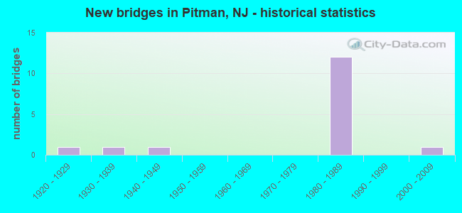
- New bridges - historical statistics
- 11920-1929
- 11930-1939
- 11940-1949
- 121980-1989
- 12000-2009


- Bridge Condition - Superstructure
- 50.0%Very good
- 50.0%Good

- Bridge Condition - Substructure
- 10.0%Very good
- 90.0%Good

- Bridge Condition - Channel
- 62.5%Good
- 37.5%Satisfactory

- Bridge Condition - Culverts
- 50.0%Good
- 50.0%Fair
Find on map >> Show street view
Structure Number: 805I02, Location: 0.1 MI EAST OF CR553 ALT (Lat: 39.754600, Lng: -75.148269), Route carried "on" structure: City street , Year Built: 1926, Year Reconstructed: 2015, Status: Open, Structure Length: 0.67m (2.20ft), Average Daily Traffic: 5,876 (year 2020), Truck Traffic: 4%, Average Future Daily Traffic: 7,051 (year 2040), Features Intersected: CHESTNUT BRANCH, Facility Carried by Structure: TYLERS MILL ROAD
Minimum Vertical Clearance: 30+ m (98+ ft), Kilometerpoint: 2.285, Lanes on structure: 2, Owner: County Highway Agency, Approaching Roadway Width: 7.3m (24.0ft), Material/Design: Concrete, Design/Construction: Arch - Deck, Number Of Spans In Main Unit: 1, Length of Maximum Span: 6.1m (20.0ft), Curb-To-Curb Width: 9.1m (29.9ft), Out-to-Out Width: 9.9m (32.5ft)
Condition: Superstructure: Good, Substructure: Good, Channel: Satisfactory, Structural Evaluation: Better than present minimum criteria, Deck Geometry: High priority of corrective action, Waterway Adequacy: Equal to present minimum criteria, Approach Roadway Alignment: Equal to present desirable criteria, Length Of Structure Improvement: 0.67m (2.20ft), Designated Inspection Frequency: Every 24 months, Inspection Date: April 2020, Bridge Improvement Cost: $107,000, Roadway Improvement Cost: $100,000, Total Project Cost: $423,000 ( Estimate for 2020)
Find on map >> Show street view
Structure Number: 805J06, Location: 0.65 mi East of CR 553 (Lat: 39.754750, Lng: -75.117500), Route carried "on" structure: County highway 635, Year Built: 1932, Status: Open, Structure Length: 0.61m (2.00ft), Average Daily Traffic: 8,699 (year 2020), Truck Traffic: 3%, Average Future Daily Traffic: 10,439 (year 2040), Features Intersected: MANTUA CREEK
Minimum Vertical Clearance: 30+ m (98+ ft), Kilometerpoint: 5.343, Lanes on structure: 2, Owner: County Highway Agency, Approaching Roadway Width: 9.1m (29.9ft), Material/Design: Concrete, Design/Construction: Culvert, Number Of Spans In Main Unit: 1, Length of Maximum Span: 6.1m (20.0ft), Curb-To-Curb Width: 9.2m (30.2ft), Out-to-Out Width: 9.9m (32.5ft)
Condition: Channel: Good, Culverts: Good, Structural Evaluation: Better than present minimum criteria, Deck Geometry: High priority of corrective action, Waterway Adequacy: Equal to present minimum criteria, Approach Roadway Alignment: Equal to present minimum criteria, Length Of Structure Improvement: 0.85m (2.79ft), Designated Inspection Frequency: Every 24 months, Inspection Date: April 2020, Bridge Improvement Cost: $132,000, Roadway Improvement Cost: $200,000, Total Project Cost: $480,000 ( Estimate for 2020)
Find on map >> Show street view
Structure Number: 805J1, Location: 0.37 Mi. S. of CR 654 (Lat: 39.750081, Lng: -75.104189), Route carried "on" structure: County highway , Year Built: 1940, Status: Open, Structure Length: 0.64m (2.10ft), Average Daily Traffic: 2,526 (year 2021), Truck Traffic: 4%, Average Future Daily Traffic: 3,079 (year 2041), Features Intersected: Porch Branch, Facility Carried by Structure: Holly Ave
Minimum Vertical Clearance: 30+ m (98+ ft), Kilometerpoint: 0.595, Lanes on structure: 2, Owner: County Highway Agency, Approaching Roadway Width: 9.1m (29.9ft), Material/Design: Steel, Design/Construction: Culvert, Number Of Spans In Main Unit: 2, Length of Maximum Span: 2.7m (8.9ft), Curb-To-Curb Width: 7.1m (23.3ft), Out-to-Out Width: 11.4m (37.4ft)
Condition: Channel: Satisfactory, Culverts: Fair, Structural Evaluation: Somewhat better than minimum adequacy, Deck Geometry: High priority of replacement, Waterway Adequacy: Equal to present desirable criteria, Approach Roadway Alignment: Equal to present desirable criteria, Length Of Structure Improvement: 0.64m (2.10ft), Designated Inspection Frequency: Every 24 months, Inspection Date: October 2021
Find on map >> Show street view
Structure Number: 805J12, Location: 300' West of Rte 47 (Lat: 39.738919, Lng: -75.114669), Route carried "on" structure: County highway 624, Year Built: 2009, Status: Open, Structure Length: 0.85m (2.79ft), Average Daily Traffic: 8,662 (year 2020), Truck Traffic: 4%, Average Future Daily Traffic: 10,394 (year 2040), Features Intersected: MANTUA CREEK
Minimum Vertical Clearance: 30+ m (98+ ft), Kilometerpoint: 9.495, Lanes on structure: 2, Owner: County Highway Agency, Approaching Roadway Width: 13.7m (44.9ft), Material/Design: Concrete, Design/Construction: Arch - Deck, Number Of Spans In Main Unit: 1, Length of Maximum Span: 8.5m (27.9ft), Curb or Sidewalk Widths: Left: 1.7m (5.6ft), Right: 1.9m (6.2ft), Curb-To-Curb Width: 13.7m (44.9ft), Out-to-Out Width: 18.2m (59.7ft)
Condition: Superstructure: Good, Substructure: Very good, Channel: Good, Operating Rating: 42.1 metric tons, Method Used To Determine Operating Rating: Load and Resistance Factor Rating (LRFR) rating reported by rating factor(RF) method using HL-93 loadings, Inventory Rating: 32.4 metric tons, Method Used To Determine Inventory Rating: Load and Resistance Factor Rating (LRFR) rating reported by rating factor(RF) method using HL-93 loadings, Structural Evaluation: Better than present minimum criteria, Deck Geometry: Superior to present desirable criteria, Waterway Adequacy: Better than present minimum criteria, Approach Roadway Alignment: Equal to present desirable criteria, Designated Inspection Frequency: Every 24 months, Inspection Date: October 2020
Find on map >> Show street view
Structure Number: 828189, Location: 1.5MI N OF US322/55 INT. (Lat: 39.740839, Lng: -75.148039), Route carried "on" structure: State highway 55, Year Built: 1986, Status: Open, Structure Length: 4.11m (13.48ft), Average Daily Traffic: 26,523 (year 2020), Truck Traffic: 5%, Average Future Daily Traffic: 31,831 (year 2040), Design Load: HS 20+Mod, Features Intersected: CHESTNUT BRANCH
Minimum Vertical Clearance: 30+ m (98+ ft), Kilometerpoint: 83.782, Lanes on structure: 2, Base Highway Network: Yes, Owner: State Highway Agency, Approaching Roadway Width: 13.4m (44.0ft), Skew: 11 degrees, Material/Design: Steel, Design/Construction: Stringer/Multi-beam, Number Of Spans In Main Unit: 1, Length of Maximum Span: 39.6m (129.9ft), Curb-To-Curb Width: 13.6m (44.6ft), Out-to-Out Width: 14.7m (48.2ft)
Condition: Deck: Good, Superstructure: Very good, Substructure: Good, Channel: Good, Inventory Rating: 72.6 metric tons, Method Used To Determine Inventory Rating: Load Factor (LF), Structural Evaluation: Better than present minimum criteria, Deck Geometry: Superior to present desirable criteria, Waterway Adequacy: Superior to present desirable criteria, Approach Roadway Alignment: Equal to present desirable criteria, Designated Inspection Frequency: Every 24 months, Inspection Date: August 2020, Deck Structure Type: Concrete Cast-file-Place, Wearing Surface/Protective System: Wearing Surface: Monolithic Concrete, Deck Protection: Epoxy Coated Reinforcing
Find on map >> Show street view
Structure Number: 82819, Location: 1.5MI N. OF US322/55 INT. (Lat: 39.741350, Lng: -75.148150), Route carried "on" structure: State highway 55, Year Built: 1986, Status: Open, Structure Length: 4.11m (13.48ft), Average Daily Traffic: 24,534 (year 2020), Truck Traffic: 5%, Average Future Daily Traffic: 29,962 (year 2040), Design Load: HS 20+Mod, Features Intersected: CHESTNUT BRANCH
Minimum Vertical Clearance: 30+ m (98+ ft), Kilometerpoint: 83.782, Lanes on structure: 2, Base Highway Network: Yes, Owner: State Highway Agency, Approaching Roadway Width: 13.4m (44.0ft), Skew: 11 degrees, Material/Design: Steel, Design/Construction: Stringer/Multi-beam, Number Of Spans In Main Unit: 1, Length of Maximum Span: 39.6m (129.9ft), Curb-To-Curb Width: 13.6m (44.6ft), Out-to-Out Width: 14.7m (48.2ft)
Condition: Deck: Good, Superstructure: Very good, Substructure: Good, Channel: Satisfactory, Operating Rating: 59.0 metric tons, Method Used To Determine Operating Rating: Load Factor (LF), Inventory Rating: 35.4 metric tons, Method Used To Determine Inventory Rating: Load Factor (LF), Structural Evaluation: Better than present minimum criteria, Deck Geometry: Superior to present desirable criteria, Waterway Adequacy: Superior to present desirable criteria, Approach Roadway Alignment: Equal to present desirable criteria, Designated Inspection Frequency: Every 24 months, Inspection Date: August 2020, Deck Structure Type: Concrete Cast-file-Place, Wearing Surface/Protective System: Wearing Surface: Monolithic Concrete, Deck Protection: Epoxy Coated Reinforcing
Find on map >> Show street view
Structure Number: 828191, Location: 2 MI N.OF RT322/RT55 JUNC (Lat: 39.745689, Lng: -75.143639), Route carried "on" structure: Alternate County highway 553A, Year Built: 1988, Status: Open, Structure Length: 7.96m (26.12ft), Average Daily Traffic: 725 (year 2020), Truck Traffic: 4%, Average Future Daily Traffic: 866 (year 2040), Design Load: HS 20+Mod, Features Intersected: NJ 55
Minimum Vertical Clearance: 30+ m (98+ ft), Kilometerpoint: 3.814, Lanes on structure: 2, Lanes under structure: 4, Owner: State Highway Agency, Approaching Roadway Width: 15.2m (49.9ft), Skew: 1 degrees, Material/Design: Steel continuous, Design/Construction: Stringer/Multi-beam, Number Of Spans In Main Unit: 2, Length of Maximum Span: 39.0m (128.0ft), Curb or Sidewalk Widths: Left: 1.8m (5.9ft), Right: 1.8m (5.9ft), Curb-To-Curb Width: 15.2m (49.9ft), Out-to-Out Width: 19.5m (64.0ft)
Condition: Deck: Good, Superstructure: Good, Substructure: Good, Operating Rating: 89.8 metric tons, Method Used To Determine Operating Rating: Load Factor (LF), Inventory Rating: 59.0 metric tons, Method Used To Determine Inventory Rating: Load Factor (LF), Structural Evaluation: Better than present minimum criteria, Deck Geometry: Superior to present desirable criteria, Underclear: Equal to present minimum criteria, Approach Roadway Alignment: Equal to present desirable criteria, Designated Inspection Frequency: Every 24 months, Inspection Date: Febuary 2020, Deck Structure Type: Concrete Cast-file-Place, Wearing Surface/Protective System: Wearing Surface: Monolithic Concrete, Deck Protection: Epoxy Coated Reinforcing
Find on map >> Show street view
Structure Number: 828193, Location: 0.5 MILE S. OF COUNTY 553 (Lat: 39.751789, Lng: -75.138439), Route carried "on" structure: City street , Year Built: 1987, Status: Open, Structure Length: 8.35m (27.40ft), Average Daily Traffic: 6,590 (year 2021), Truck Traffic: 4%, Average Future Daily Traffic: 8,041 (year 2041), Design Load: HS 20+Mod, Features Intersected: NJ ROUTE 55, Facility Carried by Structure: TYLERS MILL ROAD
Minimum Vertical Clearance: 30+ m (98+ ft), Kilometerpoint: 1.352, Lanes on structure: 2, Lanes under structure: 4, Owner: State Highway Agency, Approaching Roadway Width: 12.2m (40.0ft), Skew: 2 degrees, Material/Design: Steel continuous, Design/Construction: Stringer/Multi-beam, Number Of Spans In Main Unit: 2, Length of Maximum Span: 42.4m (139.1ft), Curb or Sidewalk Widths: Left: 1.8m (5.9ft), Right: 1.8m (5.9ft), Curb-To-Curb Width: 12.2m (40.0ft), Out-to-Out Width: 16.5m (54.1ft)
Condition: Deck: Good, Superstructure: Very good, Substructure: Good, Inventory Rating: 85.3 metric tons, Method Used To Determine Inventory Rating: Load Factor (LF), Structural Evaluation: Better than present minimum criteria, Deck Geometry: Somewhat better than minimum adequacy, Underclear: Equal to present minimum criteria, Approach Roadway Alignment: Equal to present desirable criteria, Designated Inspection Frequency: Every 24 months, Inspection Date: June 2021, Deck Structure Type: Concrete Cast-file-Place, Wearing Surface/Protective System: Wearing Surface: Monolithic Concrete, Deck Protection: Epoxy Coated Reinforcing
Find on map >> Show street view
Structure Number: 832155, Location: AT NJ-55,EXIT-53 (Lat: 39.756700, Lng: -75.130619), Route carried "on" structure: County highway 553, Year Built: 1985, Status: Open, Structure Length: 10.49m (34.42ft), Average Daily Traffic: 25,810 (year 2021), Truck Traffic: 4%, Average Future Daily Traffic: 31,493 (year 2041), Design Load: HS 20+Mod, Features Intersected: NJ ROUTE 55
Minimum Vertical Clearance: 30+ m (98+ ft), Kilometerpoint: 71.246, Lanes on structure: 6, Lanes under structure: 6, Base Highway Network: Yes, Owner: State Highway Agency, Approaching Roadway Width: 23.2m (76.1ft), Skew: 21 degrees, Material/Design: Steel continuous, Design/Construction: Stringer/Multi-beam, Number Of Spans In Main Unit: 3, Length of Maximum Span: 42.7m (140.1ft), Curb or Sidewalk Widths: Left: 1.8m (5.9ft), Right: 1.8m (5.9ft), Curb-To-Curb Width: 23.2m (76.1ft), Out-to-Out Width: 32.9m (107.9ft)
Condition: Deck: Good, Superstructure: Good, Substructure: Good, Operating Rating: 68.9 metric tons, Method Used To Determine Operating Rating: Load Factor (LF), Inventory Rating: 40.8 metric tons, Method Used To Determine Inventory Rating: Load Factor (LF), Structural Evaluation: Better than present minimum criteria, Deck Geometry: Meets minimum limits, Underclear: Better than present minimum criteria, Approach Roadway Alignment: Equal to present desirable criteria, Designated Inspection Frequency: Every 24 months, Inspection Date: June 2021, Deck Structure Type: Concrete Cast-file-Place, Wearing Surface/Protective System: Wearing Surface: Latex Concrete, Deck Protection: Epoxy Coated Reinforcing
Find on map >> Show street view
Structure Number: 832156, Location: 2.05 MI SOUTH OF EXIT 56 (Lat: 39.764869, Lng: -75.120611), Route carried "on" structure: State highway 55, Year Built: 1984, Status: Open, Structure Length: 7.96m (26.12ft), Average Daily Traffic: 28,426 (year 2021), Truck Traffic: 5%, Average Future Daily Traffic: 34,112 (year 2041), Design Load: HS 20+Mod, Features Intersected: MANTUA CREEK
Minimum Vertical Clearance: 30+ m (98+ ft), Kilometerpoint: 87.420, Lanes on structure: 2, Base Highway Network: Yes, Owner: State Highway Agency, Approaching Roadway Width: 13.4m (44.0ft), Skew: 3 degrees, Material/Design: Steel, Design/Construction: Stringer/Multi-beam, Number Of Spans In Main Unit: 3, Length of Maximum Span: 26.2m (86.0ft), Curb-To-Curb Width: 13.4m (44.0ft), Out-to-Out Width: 14.5m (47.6ft)
Condition: Deck: Good, Superstructure: Good, Substructure: Good, Channel: Good, Inventory Rating: 71.7 metric tons, Method Used To Determine Inventory Rating: Load Factor (LF), Structural Evaluation: Better than present minimum criteria, Deck Geometry: Superior to present desirable criteria, Waterway Adequacy: Superior to present desirable criteria, Approach Roadway Alignment: Equal to present desirable criteria, Designated Inspection Frequency: Every 24 months, Inspection Date: September 2021, Deck Structure Type: Concrete Cast-file-Place, Wearing Surface/Protective System: Wearing Surface: Monolithic Concrete, Deck Protection: Epoxy Coated Reinforcing
Find on map >> Show street view
Structure Number: 832157, Location: 2.05 MI SOUTH OF EXIT 56 (Lat: 39.766031, Lng: -75.120789), Route carried "on" structure: State highway 55, Year Built: 1984, Status: Open, Structure Length: 8.69m (28.51ft), Average Daily Traffic: 28,983 (year 2021), Truck Traffic: 5%, Average Future Daily Traffic: 34,780 (year 2041), Design Load: HS 20+Mod, Features Intersected: MANTUA CREEK
Minimum Vertical Clearance: 30+ m (98+ ft), Kilometerpoint: 87.403, Lanes on structure: 2, Base Highway Network: Yes, Owner: State Highway Agency, Approaching Roadway Width: 13.4m (44.0ft), Material/Design: Steel, Design/Construction: Stringer/Multi-beam, Number Of Spans In Main Unit: 3, Length of Maximum Span: 28.0m (91.9ft), Curb-To-Curb Width: 13.4m (44.0ft), Out-to-Out Width: 14.5m (47.6ft)
Condition: Deck: Good, Superstructure: Very good, Substructure: Good, Channel: Good, Inventory Rating: 70.8 metric tons, Method Used To Determine Inventory Rating: Load Factor (LF), Structural Evaluation: Better than present minimum criteria, Deck Geometry: Superior to present desirable criteria, Waterway Adequacy: Superior to present desirable criteria, Approach Roadway Alignment: Equal to present desirable criteria, Designated Inspection Frequency: Every 24 months, Inspection Date: September 2021, Deck Structure Type: Concrete Cast-file-Place, Wearing Surface/Protective System: Wearing Surface: Monolithic Concrete, Deck Protection: Epoxy Coated Reinforcing
Find on map >> Show street view
Structure Number: 832158, Location: 1.8 MILES S. OF NJ 47 (Lat: 39.768919, Lng: -75.119589), Route carried "on" structure: City street , Year Built: 1985, Status: Open, Structure Length: 9.05m (29.69ft), Average Daily Traffic: 866 (year 2021), Truck Traffic: 1%, Average Future Daily Traffic: 1,039 (year 2041), Design Load: HS 20+Mod, Features Intersected: NJ 55, Facility Carried by Structure: SALINA ROAD
Minimum Vertical Clearance: 30+ m (98+ ft), Kilometerpoint: 0.000, Lanes on structure: 2, Lanes under structure: 4, Owner: State Highway Agency, Approaching Roadway Width: 12.2m (40.0ft), Material/Design: Steel continuous, Design/Construction: Stringer/Multi-beam, Number Of Spans In Main Unit: 3, Length of Maximum Span: 36.0m (118.1ft), Curb or Sidewalk Widths: Left: 1.8m (5.9ft), Right: 1.8m (5.9ft), Curb-To-Curb Width: 12.2m (40.0ft), Out-to-Out Width: 16.5m (54.1ft)
Condition: Deck: Good, Superstructure: Very good, Substructure: Good, Operating Rating: 66.2 metric tons, Method Used To Determine Operating Rating: Load Factor (LF), Inventory Rating: 39.9 metric tons, Method Used To Determine Inventory Rating: Load Factor (LF), Structural Evaluation: Better than present minimum criteria, Deck Geometry: Equal to present desirable criteria, Underclear: Equal to present minimum criteria, Approach Roadway Alignment: Equal to present desirable criteria, Designated Inspection Frequency: Every 24 months, Inspection Date: November 2021, Deck Structure Type: Concrete Cast-file-Place, Wearing Surface/Protective System: Wearing Surface: Monolithic Concrete, Deck Protection: Epoxy Coated Reinforcing
Find on map >> Show street view
Structure Number: 828191, Location: 2 MI N.OF RT322/RT55 JUNC (Lat: 39.745689, Lng: -75.143639), Route carried "under" structure: State highway 55, Year Built: 1988, Structure Length: 0. m, Average Daily Traffic: 61,716 (year 2020), Truck Traffic: 5%, Features Intersected: NJ 55
Minimum Vertical Clearance: 5.24m (17.19ft), Kilometerpoint: 84.442, Lanes on structure: 2, Lanes under structure: 4, Material/Design: Steel continuous, Design/Construction: Stringer/Multi-beam, Length of Maximum Span: 39.0m (128.0ft)
Find on map >> Show street view
Structure Number: 828193, Location: 0.5 MILE S. OF COUNTY 553 (Lat: 39.751789, Lng: -75.138439), Route carried "under" structure: State highway 55, Year Built: 1987, Structure Length: 0. m, Average Daily Traffic: 49,578 (year 2021), Truck Traffic: 5%, Features Intersected: NJ ROUTE 55, Facility Carried by Structure: TYLERS MILL ROAD
Minimum Vertical Clearance: 5.94m (19.49ft), Kilometerpoint: 85.247, Lanes on structure: 2, Lanes under structure: 4, Material/Design: Steel continuous, Design/Construction: Stringer/Multi-beam, Length of Maximum Span: 42.4m (139.1ft)
Find on map >> Show street view
Structure Number: 832155, Location: AT NJ-55,EXIT-53 (Lat: 39.756700, Lng: -75.130619), Route carried "under" structure: State highway 55, Year Built: 1985, Structure Length: 0. m, Average Daily Traffic: 62,315 (year 2021), Truck Traffic: 4%, Features Intersected: NJ ROUTE 55
Minimum Vertical Clearance: 5.21m (17.09ft), Kilometerpoint: 86.084, Lanes on structure: 6, Lanes under structure: 6, Material/Design: Steel continuous, Design/Construction: Stringer/Multi-beam, Length of Maximum Span: 42.7m (140.1ft)
Find on map >> Show street view
Structure Number: 832158, Location: 1.8 MILES S. OF NJ 47 (Lat: 39.768919, Lng: -75.119589), Route carried "under" structure: State highway 55, Year Built: 1985, Structure Length: 0. m, Average Daily Traffic: 56,103 (year 2019), Truck Traffic: 5%, Features Intersected: NJ 55, Facility Carried by Structure: SALINA ROAD
Minimum Vertical Clearance: 5.16m (16.93ft), Kilometerpoint: 87.806, Lanes on structure: 2, Lanes under structure: 4, Material/Design: Steel continuous, Design/Construction: Stringer/Multi-beam, Length of Maximum Span: 36.0m (118.1ft)