Bridge Statistics for Pittsford, New York (NY)
Condition, Traffic, Stress, Structural Evaluation, Project Costs
- National Bridge Inventory (NBI) Statistics
- 16Number of bridges
- 161ft / 48.7mTotal length
- $57,834,000Total costs
- 183,132Total average daily traffic
- 6,111Total average daily truck traffic
- National Bridge Inventory (NBI) Registered Bridges for Pittsford
- No street view available for this location
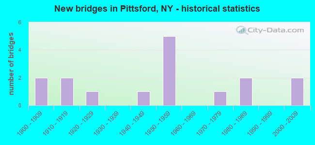
- New bridges - historical statistics
- 21900-1909
- 21910-1919
- 11920-1929
- 11940-1949
- 51950-1959
- 11970-1979
- 21980-1989
- 22000-2009

- Reconstructed bridges - Historical Statistics
- 11960-1969
- 01970-1979
- 01980-1989
- 11990-1999
- 02000-2009
- 32010-2019


- Bridge Condition - Deck
- 12.5%Excellent
- 25.0%Good
- 25.0%Satisfactory
- 25.0%Fair
- 12.5%Poor

- Bridge Condition - Superstructure
- 33.3%Very good
- 33.3%Good
- 11.1%Satisfactory
- 11.1%Fair
- 11.1%Poor

- Bridge Condition - Substructure
- 11.1%Very good
- 55.6%Good
- 33.3%Satisfactory

- Bridge Condition - Channel
- 42.9%Very good
- 14.3%Good
- 28.6%Satisfactory
- 14.3%Fair
Find on map >> Show street view
Structure Number: 104894, Location: .5 MI E JCT SH153 & CR35 (Lat: 43.096936, Lng: -77.501475), Route carried "on" structure: County highway , Year Built: 2000, Status: Open, Structure Length: 6.40m (21.00ft), Average Daily Traffic: 2,421 (year 2017), Truck Traffic: 2%, Average Future Daily Traffic: 3,389 (year 2037), Design Load: HS 25 or greater, Features Intersected: 490I490I43023042 WB, RTE, Facility Carried by Structure: GOLF AVENUE
Minimum Vertical Clearance: 30+ m (98+ ft), Kilometerpoint: 0.805, Lanes on structure: 2, Lanes under structure: 4, Owner: State Highway Agency, Approaching Roadway Width: 9.8m (32.2ft), Material/Design: Steel continuous, Design/Construction: Stringer/Multi-beam, Number Of Spans In Main Unit: 2, Length of Maximum Span: 31.7m (104.0ft), Curb-To-Curb Width: 9.8m (32.2ft), Out-to-Out Width: 10.8m (35.4ft)
Condition: Deck: Good, Superstructure: Very good, Substructure: Very good, Inventory Rating: 64.4 metric tons, Method Used To Determine Inventory Rating: Load Factor (LF), Structural Evaluation: Equal to present desirable criteria, Deck Geometry: Meets minimum limits, Underclear: High priority of corrective action, Approach Roadway Alignment: Equal to present minimum criteria, Length Of Structure Improvement: 6.40m (21.00ft), Designated Inspection Frequency: Every 24 months, Inspection Date: June 2020, Bridge Improvement Cost: $1,731,000, Roadway Improvement Cost: $1,014,000, Total Project Cost: $2,744,000 ( Estimate for 2021), Deck Structure Type: Concrete Cast-file-Place, Wearing Surface/Protective System: Wearing Surface: Integral Concrete, Deck Protection: Epoxy Coated Reinforcing
Find on map >> Show street view
Structure Number: 331728, Location: 3 MI.S.E. OF PITTSFORD (Lat: 43.054458, Lng: -77.490267), Route carried "on" structure: County highway , Year Built: 1984, Status: Open, Structure Length: 1.89m (6.20ft), Average Daily Traffic: 5,100 (year 2018), Truck Traffic: 3%, Average Future Daily Traffic: 6,310 (year 2040), Design Load: HS 20, Features Intersected: IRONDEQUOIT CREEK, Facility Carried by Structure: THORNELL RD.
Minimum Vertical Clearance: 30+ m (98+ ft), Kilometerpoint: 2.655, Lanes on structure: 2, Owner: County Highway Agency, Approaching Roadway Width: 12.2m (40.0ft), Skew: 3 degrees, Material/Design: Steel, Design/Construction: Stringer/Multi-beam, Number Of Spans In Main Unit: 1, Length of Maximum Span: 18.2m (59.7ft), Curb or Sidewalk Widths: Left: 0.0m, Right: 1.7m (5.6ft), Curb-To-Curb Width: 12.2m (40.0ft), Out-to-Out Width: 14.5m (47.6ft)
Condition: Deck: Satisfactory, Superstructure: Good, Substructure: Good, Channel: Satisfactory, Inventory Rating: 62.6 metric tons, Method Used To Determine Inventory Rating: Load Factor (LF), Structural Evaluation: Better than present minimum criteria, Deck Geometry: Somewhat better than minimum adequacy, Waterway Adequacy: Equal to present minimum criteria, Approach Roadway Alignment: Equal to present desirable criteria, Length Of Structure Improvement: 1.88m (6.17ft), Designated Inspection Frequency: Every 24 months, Inspection Date: November 2020, Bridge Improvement Cost: $1,336,000, Roadway Improvement Cost: $782,000, Total Project Cost: $2,119,000 ( Estimate for 2021), Deck Structure Type: Concrete Cast-file-Place, Wearing Surface/Protective System: Wearing Surface: Integral Concrete, Deck Protection: Epoxy Coated Reinforcing
Find on map >> Show street view
Structure Number: 331787, Location: 3/4 MI SW OF PITTSFORD (Lat: 43.080156, Lng: -77.494725), Route carried "on" structure: County highway , Year Built: 1928, Year Reconstructed: 2010, Status: Open, Structure Length: 0.82m (2.69ft), Average Daily Traffic: 3,110 (year 2019), Truck Traffic: 2%, Average Future Daily Traffic: 3,848 (year 2040), Design Load: HS 25 or greater, Features Intersected: CULLEN'S RUN CRK., Facility Carried by Structure: MARSH ROAD CR 38
Minimum Vertical Clearance: 30+ m (98+ ft), Kilometerpoint: 2.864, Lanes on structure: 2, Owner: County Highway Agency, Approaching Roadway Width: 10.1m (33.1ft), Material/Design: Prestressed concrete, Design/Construction: Box Beam or Girders - Multiple, Number Of Spans In Main Unit: 1, Length of Maximum Span: 7.9m (25.9ft), Curb-To-Curb Width: 9.2m (30.2ft), Out-to-Out Width: 9.9m (32.5ft)
Condition: Superstructure: Very good, Substructure: Good, Channel: Fair, Operating Rating: 98.0 metric tons, Method Used To Determine Operating Rating: Load Factor (LF), Inventory Rating: 59.0 metric tons, Method Used To Determine Inventory Rating: Load Factor (LF), Structural Evaluation: Better than present minimum criteria, Deck Geometry: Meets minimum limits, Waterway Adequacy: Equal to present minimum criteria, Approach Roadway Alignment: Equal to present minimum criteria, Length Of Structure Improvement: 0.82m (2.69ft), Designated Inspection Frequency: Every 24 months, Inspection Date: June 2020, Bridge Improvement Cost: $347,000, Roadway Improvement Cost: $203,000, Total Project Cost: $550,000 ( Estimate for 2021), Wearing Surface/Protective System: Wearing Surface: Bituminous
Find on map >> Show street view
Structure Number: 403519, Location: 1 MI W JCT BARGE C & I490 (Lat: 43.067894, Lng: -77.489733), Route carried "on" structure: State highway 96, Year Built: 1916, Status: Open, Structure Length: 0.91m (2.99ft), Average Daily Traffic: 10,730 (year 2020), Truck Traffic: 3%, Average Future Daily Traffic: 13,034 (year 2040), Features Intersected: Marsh Road, Erie Canal,
Minimum Vertical Clearance: 30+ m (98+ ft), Kilometerpoint: 5.503, Lanes on structure: 2, Base Highway Network: Yes, Owner: State Highway Agency, Approaching Roadway Width: 11.0m (36.1ft), Navigation Control: Yes ( Vertical Clearance: 999.9m (3,280.5ft), Horizontal Clearance: 22.9m (75.1ft)), Material/Design: Concrete continuous, Design/Construction: Culvert, Number Of Spans In Main Unit: 2, Length of Maximum Span: 3.6m (11.8ft)
Condition: Channel: Satisfactory, Culverts: Good, Operating Rating: 50.1 metric tons, Method Used To Determine Operating Rating: Field evaluation and documented engineering judgment, Inventory Rating: 24.5 metric tons, Method Used To Determine Inventory Rating: Field evaluation and documented engineering judgment, Structural Evaluation: Equal to present minimum criteria, Waterway Adequacy: Meets minimum limits, Approach Roadway Alignment: Equal to present minimum criteria, Length Of Structure Improvement: 0.91m (2.99ft), Designated Inspection Frequency: Every 24 months, Inspection Date: October 2021, Bridge Improvement Cost: $599,000, Roadway Improvement Cost: $351,000, Total Project Cost: $950,000 ( Estimate for 2021)
Find on map >> Show street view
Structure Number: 444307, Location: 0.8MI SE JCT BARGE C+96 (Lat: 43.083061, Lng: -77.506269), Route carried "on" structure: Other road , Year Built: 1912, Year Reconstructed: 1997, Status: Posted for load, Structure Length: 5.91m (19.39ft), Average Daily Traffic: 5,074 (year 2017), Truck Traffic: 1%, Average Future Daily Traffic: 7,104 (year 2037), Features Intersected: Erie Canalway Trail, Eri, Facility Carried by Structure: MITCHELL ROAD
Minimum Vertical Clearance: 4.22m (13.85ft), Kilometerpoint: 0.113, Lanes on structure: 1, Owner: State Highway Agency, Approaching Roadway Width: 8.2m (26.9ft), Skew: 1 degrees, Navigation Control: Yes ( Vertical Clearance: 4.8m (15.7ft), Horizontal Clearance: 22.8m (74.8ft)), Material/Design: Steel, Design/Construction: Truss - Thru, Number Of Spans In Main Unit: 1, Number Of Approach Spans: 2, Length of Maximum Span: 46.0m (150.9ft), Curb-To-Curb Width: 4.5m (14.8ft), Out-to-Out Width: 5.0m (16.4ft)
Condition: Deck: Satisfactory, Superstructure: Fair, Substructure: Good, Channel: Very good, Operating Rating: 19.1 metric tons, Method Used To Determine Operating Rating: Field evaluation and documented engineering judgment, Inventory Rating: 19.1 metric tons, Method Used To Determine Inventory Rating: Field evaluation and documented engineering judgment, Structural Evaluation: Meets minimum limits, Deck Geometry: High priority of replacement, Waterway Adequacy: Better than present minimum criteria, Approach Roadway Alignment: High priority of corrective action, Bridge Posting: Required (Relationship of Operating Rating to Maximum Legal Load: > 39.9% below), Length Of Structure Improvement: 5.91m (19.39ft), Designated Inspection Frequency: Every 12 months, Critical Feature Inspection Frequency: Every 12 months, Inspection Date: November 2021, Critical Feature Inspection Date: November 2021, Bridge Improvement Cost: $2,560,000, Roadway Improvement Cost: $1,499,000, Total Project Cost: $4,059,000 ( Estimate for 2021), Wearing Surface/Protective System: Wearing Surface: Integral Concrete
Find on map >> Show street view
Structure Number: 444327, Location: JCT RTE 31F+STATE BARGE C (Lat: 43.089511, Lng: -77.511425), Route carried "on" structure: State highway 31, Year Built: 1974, Year Reconstructed: 2021, Status: Open, Structure Length: 7.86m (25.79ft), Average Daily Traffic: 8,811 (year 2020), Truck Traffic: 3%, Average Future Daily Traffic: 8,852 (year 2040), Design Load: HS 20, Features Intersected: Canalway Trail, ERIE CAN
Minimum Vertical Clearance: 5.68m (18.64ft), Kilometerpoint: 46.870, Lanes on structure: 2, Base Highway Network: Yes, Owner: State Highway Agency, Approaching Roadway Width: 9.8m (32.2ft), Skew: 2 degrees, Navigation Control: Yes ( Vertical Clearance: 47.2m (154.9ft), Horizontal Clearance: 37.4m (122.7ft)), Material/Design: Steel, Design/Construction: Truss - Thru, Number Of Spans In Main Unit: 1, Length of Maximum Span: 77.7m (254.9ft), Curb or Sidewalk Widths: Left: 2.1m (6.9ft), Right: 2.1m (6.9ft), Curb-To-Curb Width: 9.8m (32.2ft), Out-to-Out Width: 14.8m (48.6ft)
Condition: Deck: Excellent, Superstructure: Good, Substructure: Good, Channel: Very good, Operating Rating: 90.7 metric tons, Method Used To Determine Operating Rating: Load Factor (LF), Inventory Rating: 54.4 metric tons, Method Used To Determine Inventory Rating: Load Factor (LF), Structural Evaluation: Better than present minimum criteria, Deck Geometry: Meets minimum limits, Waterway Adequacy: Superior to present desirable criteria, Approach Roadway Alignment: Equal to present desirable criteria, Length Of Structure Improvement: 7.86m (25.79ft), Designated Inspection Frequency: Every 24 months, Critical Feature Inspection Frequency: Every 24 months, Inspection Date: August 2021, Critical Feature Inspection Date: August 2021, Bridge Improvement Cost: $9,928,000, Roadway Improvement Cost: $5,814,000, Total Project Cost: $15,742,000 ( Estimate for 2021), Deck Structure Type: Concrete Cast-file-Place, Wearing Surface/Protective System: Wearing Surface: Integral Concrete
Find on map >> Show street view
Structure Number: 4443289, Location: RTE 253 OVER BARGE CANAL (Lat: 43.092381, Lng: -77.514606), Route carried "on" structure: State highway 96, Year Built: 1985, Status: Open, Structure Length: 4.48m (14.70ft), Average Daily Traffic: 12,872 (year 2020), Truck Traffic: 3%, Average Future Daily Traffic: 15,636 (year 2040), Design Load: HS 20, Features Intersected: ERIE CANAL, BIKEWAY
Minimum Vertical Clearance: 30+ m (98+ ft), Kilometerpoint: 9.429, Lanes on structure: 2, Base Highway Network: Yes, Owner: State Highway Agency, Approaching Roadway Width: 12.5m (41.0ft), Skew: 2 degrees, Navigation Control: Yes ( Vertical Clearance: 4.8m (15.7ft), Horizontal Clearance: 22.8m (74.8ft)), Material/Design: Steel, Design/Construction: Truss - Thru, Number Of Spans In Main Unit: 1, Length of Maximum Span: 42.6m (139.8ft), Curb or Sidewalk Widths: Left: 1.5m (4.9ft), Right: 1.5m (4.9ft), Curb-To-Curb Width: 12.5m (41.0ft), Out-to-Out Width: 16.5m (54.1ft)
Condition: Deck: Poor, Superstructure: Very good, Substructure: Good, Channel: Very good, Inventory Rating: 32.7 metric tons, Method Used To Determine Inventory Rating: Field evaluation and documented engineering judgment, Structural Evaluation: Better than present minimum criteria, Deck Geometry: Somewhat better than minimum adequacy, Waterway Adequacy: Somewhat better than minimum adequacy, Approach Roadway Alignment: Equal to present desirable criteria, Length Of Structure Improvement: 4.48m (14.70ft), Designated Inspection Frequency: Every 24 months, Critical Feature Inspection Frequency: Every 24 months, Inspection Date: August 2020, Critical Feature Inspection Date: August 2020, Bridge Improvement Cost: $5,987,000, Roadway Improvement Cost: $3,506,000, Total Project Cost: $9,492,000 ( Estimate for 2021), Deck Structure Type: Concrete Cast-file-Place, Wearing Surface/Protective System: Wearing Surface: Integral Concrete, Deck Protection: Epoxy Coated Reinforcing
Find on map >> Show street view
Structure Number: 444329, Location: RTE.31(MONROE AV) + CANAL (Lat: 43.093314, Lng: -77.521842), Route carried "on" structure: State highway 31, Year Built: 1941, Year Reconstructed: 1973, Status: Open, Structure Length: 11.67m (38.29ft), Average Daily Traffic: 15,115 (year 2020), Truck Traffic: 2%, Average Future Daily Traffic: 15,186 (year 2040), Design Load: HS 20, Features Intersected: Canalway Trail, ERIE CAN
Minimum Vertical Clearance: 4.83m (15.85ft), Kilometerpoint: 45.824, Lanes on structure: 2, Base Highway Network: Yes, Owner: State Highway Agency, Approaching Roadway Width: 12.8m (42.0ft), Skew: 24 degrees, Navigation Control: Yes ( Vertical Clearance: 6.4m (21.0ft), Horizontal Clearance: 22.8m (74.8ft)), Material/Design: Steel, Design/Construction: Truss - Thru, Number Of Spans In Main Unit: 1, Number Of Approach Spans: 2, Length of Maximum Span: 73.1m (239.8ft), Curb or Sidewalk Widths: Left: 1.5m (4.9ft), Right: 1.5m (4.9ft), Curb-To-Curb Width: 12.8m (42.0ft), Out-to-Out Width: 13.7m (44.9ft)
Condition: Deck: Fair, Superstructure: Poor, Substructure: Satisfactory, Channel: Good, Operating Rating: 86.7 metric tons, Method Used To Determine Operating Rating: Field evaluation and documented engineering judgment, Inventory Rating: 32.7 metric tons, Method Used To Determine Inventory Rating: Field evaluation and documented engineering judgment, Structural Evaluation: Meets minimum limits, Deck Geometry: Somewhat better than minimum adequacy, Waterway Adequacy: Superior to present desirable criteria, Approach Roadway Alignment: Equal to present desirable criteria, Length Of Structure Improvement: 11.67m (38.29ft), Designated Inspection Frequency: Every 24 months, Critical Feature Inspection Frequency: Every 24 months, Inspection Date: November 2020, Critical Feature Inspection Date: November 2020, Bridge Improvement Cost: $10,160,000, Roadway Improvement Cost: $5,950,000, Total Project Cost: $16,109,000 ( Estimate for 2021), Deck Structure Type: Concrete Cast-file-Place, Wearing Surface/Protective System: Wearing Surface: Integral Concrete
Find on map >> Show street view
Structure Number: 5510581, Location: 5.7 MI.E.EXIT 46 I90 (Lat: 43.039839, Lng: -77.541378), Route carried "on" structure: Interstate 90, Year Built: 1952, Year Reconstructed: 2017, Status: Open, Structure Length: 4.36m (14.30ft), Average Daily Traffic: 11,530 (year 2020), Truck Traffic: 31%, Average Future Daily Traffic: 16,035 (year 2040), Design Load: HS 20, Features Intersected: MENDON CENTER RD
Minimum Vertical Clearance: 30+ m (98+ ft), Kilometerpoint: 30.153, Lanes on structure: 2, Lanes under structure: 2, Base Highway Network: Yes, Toll: On Interstate toll segment, Owner: State Toll Authority, Approaching Roadway Width: 14.9m (48.9ft), Skew: 3 degrees, Material/Design: Steel, Design/Construction: Stringer/Multi-beam, Number Of Spans In Main Unit: 3, Length of Maximum Span: 18.9m (62.0ft), Curb-To-Curb Width: 16.5m (54.1ft), Out-to-Out Width: 17.2m (56.4ft)
Condition: Deck: Good, Superstructure: Good, Substructure: Satisfactory, Operating Rating: 34.7 metric tons, Method Used To Determine Operating Rating: Load and Resistance Factor Rating (LRFR) rating reported by rating factor(RF) method using HL-93 loadings, Inventory Rating: 26.6 metric tons, Method Used To Determine Inventory Rating: Load and Resistance Factor Rating (LRFR) rating reported by rating factor(RF) method using HL-93 loadings, Structural Evaluation: Equal to present minimum criteria, Deck Geometry: Superior to present desirable criteria, Underclear: High priority of corrective action, Approach Roadway Alignment: Equal to present desirable criteria, Length Of Structure Improvement: 4.35m (14.27ft), Designated Inspection Frequency: Every 24 months, Inspection Date: September 2020, Bridge Improvement Cost: $1,952,000, Roadway Improvement Cost: $1,143,000, Total Project Cost: $3,095,000 ( Estimate for 2021), Deck Structure Type: Concrete Cast-file-Place, Wearing Surface/Protective System: Wearing Surface: Monolithic Concrete, Deck Protection: Epoxy Coated Reinforcing
Find on map >> Show street view
Structure Number: 5510582, Location: 5.8 MI W EXIT 45 OF I90 (Lat: 43.040108, Lng: -77.541414), Route carried "on" structure: Interstate 90, Year Built: 1952, Year Reconstructed: 2017, Status: Open, Structure Length: 4.36m (14.30ft), Average Daily Traffic: 15,060 (year 2014), Truck Traffic: 6%, Design Load: HS 20, Features Intersected: MENDON CENTER RD
Minimum Vertical Clearance: 30+ m (98+ ft), Kilometerpoint: 573.914, Lanes on structure: 2, Lanes under structure: 2, Base Highway Network: Yes, Toll: On Interstate toll segment, Owner: State Toll Authority, Approaching Roadway Width: 15.8m (51.8ft), Skew: 3 degrees, Material/Design: Steel, Design/Construction: Stringer/Multi-beam, Number Of Spans In Main Unit: 3, Length of Maximum Span: 18.9m (62.0ft), Curb-To-Curb Width: 16.6m (54.5ft), Out-to-Out Width: 17.2m (56.4ft)
Condition: Deck: Fair, Superstructure: Satisfactory, Substructure: Satisfactory, Operating Rating: 70.8 metric tons, Method Used To Determine Operating Rating: Load Factor (LF), Inventory Rating: 42.6 metric tons, Method Used To Determine Inventory Rating: Load Factor (LF), Structural Evaluation: Equal to present minimum criteria, Deck Geometry: Superior to present desirable criteria, Underclear: Meets minimum limits, Approach Roadway Alignment: Equal to present desirable criteria, Length Of Structure Improvement: 4.35m (14.27ft), Designated Inspection Frequency: Every 24 months, Inspection Date: September 2020, Bridge Improvement Cost: $1,876,000, Roadway Improvement Cost: $1,098,000, Total Project Cost: $2,974,000 ( Estimate for 2021), Deck Structure Type: Concrete Cast-file-Place, Wearing Surface/Protective System: Wearing Surface: Epoxy Overlay, Deck Protection: Epoxy Coated Reinforcing
Find on map >> Show street view
Structure Number: 104894, Location: .5 MI E JCT SH153 & CR35 (Lat: 43.096936, Lng: -77.501475), Route carried "under" structure: Interstate 490, Year Built: 2000, Structure Length: 0. m, Average Daily Traffic: 56,000 (year 1999), Features Intersected: 490I490I43023042 WB, RTE, Facility Carried by Structure: GOLF AVENUE
Minimum Vertical Clearance: 4.67m (15.32ft), Kilometerpoint: 6.838, Lanes on structure: 2, Lanes under structure: 2, Material/Design: Steel continuous, Design/Construction: Stringer/Multi-beam, Length of Maximum Span: 31.7m (104.0ft)
Find on map >> Show street view
Structure Number: 5510581, Location: 5.7 MI.E.EXIT 46 I90 (Lat: 43.039839, Lng: -77.541378), Route carried "under" structure: County highway , Year Built: 1952, Structure Length: 0. m, Average Daily Traffic: 1,777 (year 2008), Features Intersected: MENDON CENTER RD, Facility Carried by Structure: RTE I90
Minimum Vertical Clearance: 4.24m (13.91ft), Kilometerpoint: 0.000, Lanes on structure: 2, Lanes under structure: 2, Toll: On toll road, Material/Design: Steel, Design/Construction: Stringer/Multi-beam, Length of Maximum Span: 18.9m (62.0ft)
Find on map >> Show street view
Structure Number: 5510582, Location: 5.8 MI W EXIT 45 OF I90 (Lat: 43.040108, Lng: -77.541414), Route carried "under" structure: County highway , Year Built: 1952, Structure Length: 0. m, Average Daily Traffic: 1,777 (year 2008), Features Intersected: MENDON CENTER RD, Facility Carried by Structure: RTE I90
Minimum Vertical Clearance: 4.32m (14.17ft), Kilometerpoint: 0.000, Lanes on structure: 2, Lanes under structure: 2, Toll: On toll road, Material/Design: Steel, Design/Construction: Stringer/Multi-beam, Length of Maximum Span: 18.9m (62.0ft)
Find on map >> Show street view
Structure Number: 703521, Location: 0.1MI N JCT96+BARGE CANAL (Lat: 43.094911, Lng: -77.513997), Route carried "under" structure: State highway 96, Year Built: 1905, Structure Length: 0. m, Average Daily Traffic: 8,334 (year 1999), Features Intersected: RTE 96, Facility Carried by Structure: CSX TRANSPRTATION
Minimum Vertical Clearance: 0.00m, Kilometerpoint: 9.767, Lanes under structure: 4, Material/Design: Steel continuous, Design/Construction: Girder and Floorbeam System, Length of Maximum Span: 12.4m (40.7ft)
Find on map >> Show street view
Structure Number: 704893, Location: 0.5MI S JCT RTS I490+253 (Lat: 43.097258, Lng: -77.501561), Route carried "under" structure: Interstate 490, Year Built: 1955, Structure Length: 0. m, Average Daily Traffic: 23,000 (year 1971), Features Intersected: RTE I490, Facility Carried by Structure: CSX TRANSPRTATION
Minimum Vertical Clearance: 5.18m (16.99ft), Kilometerpoint: 6.806, Lanes under structure: 4, Material/Design: Steel continuous, Design/Construction: Girder and Floorbeam System, Length of Maximum Span: 27.4m (89.9ft)
Find on map >> Show street view
Structure Number: 770682, Location: 0.7 MI SW OF E ROCHESTER (Lat: 43.096797, Lng: -77.506217), Route carried "under" structure: County highway , Year Built: 1905, Structure Length: 0. m, Average Daily Traffic: 2,421 (year 2017), Truck Traffic: 2%, Features Intersected: GOLF AVE C R 35, Facility Carried by Structure: CSX TRANSPRTATION
Minimum Vertical Clearance: 3.53m (11.58ft), Kilometerpoint: 0.000, Lanes under structure: 2, Material/Design: Steel, Design/Construction: Stringer/Multi-beam, Length of Maximum Span: 9.7m (31.8ft)