Bridge Statistics for Rapid City, South Dakota (SD)
Condition, Traffic, Stress, Structural Evaluation, Project Costs
- National Bridge Inventory (NBI) Statistics
- 111Number of bridges
- 1,063ft / 324mTotal length
- $6,961,000Total costs
- 987,903Total average daily traffic
- 55,193Total average daily truck traffic
- National Bridge Inventory (NBI) Registered Bridges for Rapid City
- No street view available for this location
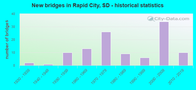
- New bridges - historical statistics
- 21930-1939
- 11940-1949
- 101950-1959
- 131960-1969
- 261970-1979
- 91980-1989
- 61990-1999
- 342000-2009
- 102010-2019
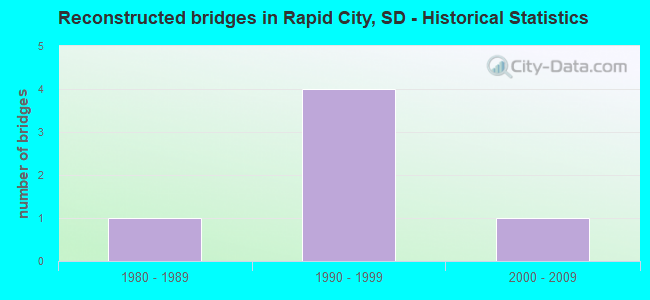
- Reconstructed bridges - Historical Statistics
- 11980-1989
- 41990-1999
- 12000-2009
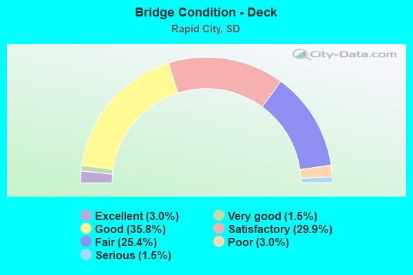
- Bridge Condition - Deck
- 3.0%Excellent
- 1.5%Very good
- 35.8%Good
- 29.9%Satisfactory
- 25.4%Fair
- 3.0%Poor
- 1.5%Serious
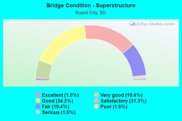
- Bridge Condition - Superstructure
- 1.5%Excellent
- 10.4%Very good
- 34.3%Good
- 31.3%Satisfactory
- 19.4%Fair
- 1.5%Poor
- 1.5%Serious
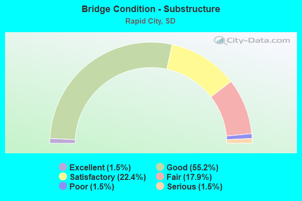
- Bridge Condition - Substructure
- 1.5%Excellent
- 55.2%Good
- 22.4%Satisfactory
- 17.9%Fair
- 1.5%Poor
- 1.5%Serious
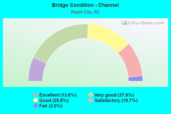
- Bridge Condition - Channel
- 13.6%Excellent
- 37.9%Very good
- 25.8%Good
- 19.7%Satisfactory
- 3.0%Fair

- Bridge Condition - Culverts
- 37.5%Very good
- 18.8%Good
- 37.5%Satisfactory
- 6.3%Serious
Find on map >> Show street view
Structure Number: 524202, Location: 1.2E of Scotland (Lat: 43.140258, Lng: -97.692997), Route carried "on" structure: Other road , Year Built: 1939, Status: Open, Structure Length: 0.75m (2.46ft), Average Daily Traffic: 138 (year 2019), Truck Traffic: 2%, Average Future Daily Traffic: 138 (year 2032), Features Intersected: Creek, Facility Carried by Structure: 42520 293rd Street
Minimum Vertical Clearance: 30+ m (98+ ft), Kilometerpoint: 0.000, Lanes on structure: 2, Owner: County Highway Agency, Approaching Roadway Width: 7.3m (24.0ft), Material/Design: Concrete continuous, Design/Construction: Culvert, Number Of Spans In Main Unit: 2, Length of Maximum Span: 3.7m (12.1ft)
Condition: Channel: Fair, Culverts: Serious, Operating Rating: 32.7 metric tons, Method Used To Determine Operating Rating: Field evaluation and documented engineering judgment, Inventory Rating: 24.5 metric tons, Method Used To Determine Inventory Rating: Field evaluation and documented engineering judgment, Structural Evaluation: High priority of corrective action, Waterway Adequacy: Equal to present desirable criteria, Approach Roadway Alignment: Equal to present desirable criteria, Length Of Structure Improvement: 1.01m (3.31ft), Designated Inspection Frequency: Every 12 months, Inspection Date: May 2021, Bridge Improvement Cost: $382,000, Roadway Improvement Cost: $30,000, Total Project Cost: $412,000 ( Estimate for 2017)
Find on map >> Show street view
Structure Number: 47170612, Location: 3.8E 0.1S BLACK HAWK (Lat: 44.153872, Lng: -103.231453), Route carried "on" structure: County highway , Year Built: 2003, Status: Open, Structure Length: 1.18m (3.87ft), Average Daily Traffic: 1,895 (year 2019), Truck Traffic: 3%, Average Future Daily Traffic: 2,180 (year 2032), Design Load: HS 20+Mod, Features Intersected: BOX ELDER CK, Facility Carried by Structure: COUNTY RD
Minimum Vertical Clearance: 30+ m (98+ ft), Kilometerpoint: 0.000, Lanes on structure: 2, Owner: County Highway Agency, Approaching Roadway Width: 10.4m (34.1ft), Skew: 1 degrees, Material/Design: Concrete continuous, Design/Construction: Culvert, Number Of Spans In Main Unit: 3, Length of Maximum Span: 3.8m (12.5ft)
Condition: Channel: Excellent, Culverts: Good, Operating Rating: 68.4 metric tons, Method Used To Determine Operating Rating: Load Factor (LF), Inventory Rating: 40.9 metric tons, Method Used To Determine Inventory Rating: Load Factor (LF), Structural Evaluation: Better than present minimum criteria, Waterway Adequacy: Superior to present desirable criteria, Approach Roadway Alignment: Superior to present desirable criteria, Designated Inspection Frequency: Every 48 months, Inspection Date: June 2020
Find on map >> Show street view
Structure Number: 47190607, Location: 16E & 17.7S STURGIS (Lat: 44.157517, Lng: -103.191383), Route carried "on" structure: County highway , Year Built: 1966, Status: Open, Structure Length: 2.16m (7.09ft), Average Daily Traffic: 15 (year 2019), Truck Traffic: 2%, Average Future Daily Traffic: 15 (year 2032), Design Load: HS 20, Features Intersected: BOXELDER CK, Facility Carried by Structure: 143RD AVE.
Minimum Vertical Clearance: 30+ m (98+ ft), Kilometerpoint: 0.000, Lanes on structure: 2, Owner: County Highway Agency, Approaching Roadway Width: 5.5m (18.0ft), Material/Design: Prestressed concrete, Design/Construction: Tee Beam, Number Of Spans In Main Unit: 2, Length of Maximum Span: 11.6m (38.1ft), Curb-To-Curb Width: 7.0m (23.0ft), Out-to-Out Width: 7.0m (23.0ft)
Condition: Deck: Satisfactory, Superstructure: Good, Substructure: Satisfactory, Channel: Fair, Operating Rating: 32.7 metric tons, Method Used To Determine Operating Rating: Field evaluation and documented engineering judgment, Inventory Rating: 24.5 metric tons, Method Used To Determine Inventory Rating: Field evaluation and documented engineering judgment, Structural Evaluation: Equal to present minimum criteria, Deck Geometry: Somewhat better than minimum adequacy, Waterway Adequacy: Equal to present desirable criteria, Approach Roadway Alignment: Better than present minimum criteria, Length Of Structure Improvement: 3.14m (10.30ft), Designated Inspection Frequency: Every 24 months, Inspection Date: June 2020, Bridge Improvement Cost: $5,000, Total Project Cost: $5,000, Deck Structure Type: Concrete Cast-file-Place, Wearing Surface/Protective System: Wearing Surface: Monolithic Concrete
Find on map >> Show street view
Structure Number: 4719261, Location: 6.0 E BLACKHAWK (Lat: 44.154794, Lng: -103.187339), Route carried "on" structure: County highway , Year Built: 2004, Status: Open, Structure Length: 1.32m (4.33ft), Average Daily Traffic: 35 (year 2019), Truck Traffic: 8%, Average Future Daily Traffic: 37 (year 2032), Design Load: HS 20+Mod, Features Intersected: BOXELDER CK, Facility Carried by Structure: 224 ST
Minimum Vertical Clearance: 30+ m (98+ ft), Kilometerpoint: 0.000, Lanes on structure: 2, Owner: County Highway Agency, Approaching Roadway Width: 8.5m (27.9ft), Material/Design: Concrete continuous, Design/Construction: Culvert, Number Of Spans In Main Unit: 3, Length of Maximum Span: 4.3m (14.1ft)
Condition: Channel: Excellent, Culverts: Very good, Structural Evaluation: Equal to present desirable criteria, Waterway Adequacy: Superior to present desirable criteria, Approach Roadway Alignment: Superior to present desirable criteria, Designated Inspection Frequency: Every 48 months, Inspection Date: June 2020
Find on map >> Show street view
Structure Number: 52363326, Location: 1.3W 0.9S FISH HATCH (Lat: 44.044892, Lng: -103.326769), Route carried "on" structure: County highway , Year Built: 1972, Status: Open, Structure Length: 2.13m (6.99ft), Average Daily Traffic: 50 (year 2019), Truck Traffic: 2%, Average Future Daily Traffic: 50 (year 2032), Design Load: HS 20, Features Intersected: RAPID CK, Facility Carried by Structure: DARK CANYON ROAD
Minimum Vertical Clearance: 30+ m (98+ ft), Kilometerpoint: 0.000, Lanes on structure: 2, Owner: County Highway Agency, Approaching Roadway Width: 6.7m (22.0ft), Skew: 1 degrees, Material/Design: Prestressed concrete, Design/Construction: Tee Beam, Number Of Spans In Main Unit: 2, Length of Maximum Span: 10.4m (34.1ft), Curb-To-Curb Width: 8.0m (26.2ft), Out-to-Out Width: 8.2m (26.9ft)
Condition: Deck: Good, Superstructure: Good, Substructure: Fair, Channel: Very good, Operating Rating: 62.9 metric tons, Method Used To Determine Operating Rating: Field evaluation and documented engineering judgment, Inventory Rating: 30.7 metric tons, Method Used To Determine Inventory Rating: Field evaluation and documented engineering judgment, Structural Evaluation: Somewhat better than minimum adequacy, Deck Geometry: Equal to present minimum criteria, Waterway Adequacy: Equal to present desirable criteria, Approach Roadway Alignment: Meets minimum limits, Designated Inspection Frequency: Every 24 months, Inspection Date: September 2021, Deck Structure Type: Concrete Precast Panels
Find on map >> Show street view
Structure Number: 52369321, Location: 4.2 SW JCT SD 231 (Lat: 44.051142, Lng: -103.313261), Route carried "on" structure: State highway 44, Year Built: 1967, Status: Open, Structure Length: 3.54m (11.61ft), Average Daily Traffic: 3,690 (year 2020), Truck Traffic: 4%, Average Future Daily Traffic: 6,428 (year 2040), Design Load: HS 20, Features Intersected: RAPID CK
Minimum Vertical Clearance: 30+ m (98+ ft), Kilometerpoint: 64.036, Lanes on structure: 4, Base Highway Network: Yes, Owner: State Highway Agency, Approaching Roadway Width: 15.9m (52.2ft), Skew: 22 degrees, Material/Design: Concrete continuous, Design/Construction: Slab, Number Of Spans In Main Unit: 3, Length of Maximum Span: 13.1m (43.0ft), Curb or Sidewalk Widths: Left: 1.3m (4.3ft), Right: 1.7m (5.6ft), Curb-To-Curb Width: 25.4m (83.3ft), Out-to-Out Width: 27.3m (89.6ft)
Condition: Deck: Fair, Superstructure: Fair, Substructure: Satisfactory, Channel: Very good, Operating Rating: 63.6 metric tons, Method Used To Determine Operating Rating: Load Factor (LF), Inventory Rating: 38.1 metric tons, Method Used To Determine Inventory Rating: Load Factor (LF), Structural Evaluation: Somewhat better than minimum adequacy, Deck Geometry: Superior to present desirable criteria, Waterway Adequacy: Equal to present minimum criteria, Approach Roadway Alignment: Better than present minimum criteria, Length Of Structure Improvement: 3.96m (12.99ft), Designated Inspection Frequency: Every 24 months, Inspection Date: Febuary 2021, Bridge Improvement Cost: $400,000, Roadway Improvement Cost: $75,000, Total Project Cost: $500,000, Deck Structure Type: Concrete Cast-file-Place, Wearing Surface/Protective System: Wearing Surface: Low Slump Concrete
Find on map >> Show street view
Structure Number: 5237132, Location: 4.1 SW JCT SD 231 (Lat: 44.052767, Lng: -103.311322), Route carried "on" structure: State highway 44, Year Built: 1967, Status: Open, Structure Length: 4.47m (14.67ft), Average Daily Traffic: 5,128 (year 2021), Truck Traffic: 4%, Average Future Daily Traffic: 7,051 (year 2041), Design Load: HS 20, Features Intersected: RAPID CK
Minimum Vertical Clearance: 30+ m (98+ ft), Kilometerpoint: 64.277, Lanes on structure: 4, Base Highway Network: Yes, Owner: State Highway Agency, Approaching Roadway Width: 15.9m (52.2ft), Skew: 4 degrees, Material/Design: Steel continuous, Design/Construction: Stringer/Multi-beam, Number Of Spans In Main Unit: 3, Length of Maximum Span: 16.8m (55.1ft), Curb or Sidewalk Widths: Left: 1.7m (5.6ft), Right: 1.7m (5.6ft), Curb-To-Curb Width: 15.9m (52.2ft), Out-to-Out Width: 19.8m (65.0ft)
Condition: Deck: Fair, Superstructure: Fair, Substructure: Satisfactory, Channel: Very good, Operating Rating: 48.5 metric tons, Method Used To Determine Operating Rating: Load Factor (LF), Inventory Rating: 29.0 metric tons, Method Used To Determine Inventory Rating: Load Factor (LF), Structural Evaluation: Somewhat better than minimum adequacy, Deck Geometry: Meets minimum limits, Waterway Adequacy: Equal to present desirable criteria, Approach Roadway Alignment: Better than present minimum criteria, Designated Inspection Frequency: Every 24 months, Inspection Date: March 2021, Deck Structure Type: Concrete Cast-file-Place, Wearing Surface/Protective System: Wearing Surface: Epoxy Overlay, Membrane: Epoxy
Find on map >> Show street view
Structure Number: 5237232, Location: 0.8SW CANYON LK DAM - RC (Lat: 44.053275, Lng: -103.307592), Route carried "on" structure: City street , Year Built: 1972, Status: Posted for load, Structure Length: 1.25m (4.10ft), Average Daily Traffic: 25 (year 2019), Truck Traffic: 2%, Average Future Daily Traffic: 25 (year 2032), Features Intersected: RAPID CK, Facility Carried by Structure: IDLEHURST LANE
Minimum Vertical Clearance: 30+ m (98+ ft), Kilometerpoint: 0.000, Lanes on structure: 1, Owner: City or Municipal Highway Agency, Approaching Roadway Width: 3.7m (12.1ft), Skew: 1 degrees, Material/Design: Wood or Timber, Design/Construction: Stringer/Multi-beam, Number Of Spans In Main Unit: 1, Length of Maximum Span: 12.2m (40.0ft), Curb or Sidewalk Widths: Left: 0.0m, Right: 0.2m (0.7ft), Curb-To-Curb Width: 4.4m (14.4ft), Out-to-Out Width: 4.7m (15.4ft)
Condition: Deck: Fair, Superstructure: Fair, Substructure: Fair, Channel: Satisfactory, Operating Rating: 8.4 metric tons, Method Used To Determine Operating Rating: Allowable Stress (AS), Inventory Rating: 5.3 metric tons, Method Used To Determine Inventory Rating: Allowable Stress (AS), Structural Evaluation: High priority of replacement, Deck Geometry: Equal to present minimum criteria, Waterway Adequacy: Meets minimum limits, Approach Roadway Alignment: Meets minimum limits, Bridge Posting: Required (Relationship of Operating Rating to Maximum Legal Load: > 39.9% below), Length Of Structure Improvement: 2.13m (6.99ft), Designated Inspection Frequency: Every 24 months, Inspection Date: April 2020, Bridge Improvement Cost: $110,000, Roadway Improvement Cost: $25,000, Total Project Cost: $135,000, Deck Structure Type: Wood or Timber, Wearing Surface/Protective System: Wearing Surface: Wood or Timber
Find on map >> Show street view
Structure Number: 52374318, Location: 3.6 SW JCT SD 231 (Lat: 44.057142, Lng: -103.304300), Route carried "on" structure: State highway 44, Year Built: 1967, Status: Open, Structure Length: 1.84m (6.04ft), Average Daily Traffic: 5,128 (year 2021), Truck Traffic: 4%, Average Future Daily Traffic: 7,051 (year 2041), Design Load: HS 20, Features Intersected: CLEGHORN CANYON
Minimum Vertical Clearance: 30+ m (98+ ft), Kilometerpoint: 65.050, Lanes on structure: 4, Base Highway Network: Yes, Owner: State Highway Agency, Approaching Roadway Width: 15.9m (52.2ft), Material/Design: Concrete continuous, Design/Construction: Slab, Number Of Spans In Main Unit: 3, Length of Maximum Span: 6.6m (21.7ft), Curb or Sidewalk Widths: Left: 1.7m (5.6ft), Right: 1.7m (5.6ft), Curb-To-Curb Width: 15.9m (52.2ft), Out-to-Out Width: 19.8m (65.0ft)
Condition: Deck: Good, Superstructure: Good, Substructure: Good, Channel: Very good, Operating Rating: 65.1 metric tons, Method Used To Determine Operating Rating: Load Factor (LF), Inventory Rating: 39.0 metric tons, Method Used To Determine Inventory Rating: Load Factor (LF), Structural Evaluation: Better than present minimum criteria, Deck Geometry: Meets minimum limits, Waterway Adequacy: Equal to present minimum criteria, Approach Roadway Alignment: Better than present minimum criteria, Length Of Structure Improvement: 1.84m (6.04ft), Designated Inspection Frequency: Every 24 months, Inspection Date: June 2021, Bridge Improvement Cost: $30,000, Roadway Improvement Cost: $12,000, Total Project Cost: $49,000, Deck Structure Type: Concrete Cast-file-Place, Wearing Surface/Protective System: Wearing Surface: Low Slump Concrete
Find on map >> Show street view
Structure Number: 52375262, Location: 0.2 S MEADE CO LINE (Lat: 44.137544, Lng: -103.302519), Route carried "on" structure: State highway 231, Year Built: 1947, Year Reconstructed: 1999, Status: Open, Structure Length: 1.15m (3.77ft), Average Daily Traffic: 9,235 (year 2021), Truck Traffic: 3%, Average Future Daily Traffic: 12,698 (year 2041), Design Load: H 15, Features Intersected: HIGH CK
Minimum Vertical Clearance: 30+ m (98+ ft), Kilometerpoint: 137.003, Lanes on structure: 3, Owner: State Highway Agency, Approaching Roadway Width: 14.0m (45.9ft), Skew: 3 degrees, Material/Design: Concrete continuous, Design/Construction: Culvert, Number Of Spans In Main Unit: 3, Length of Maximum Span: 3.7m (12.1ft)
Condition: Channel: Good, Culverts: Satisfactory, Operating Rating: 32.7 metric tons, Method Used To Determine Operating Rating: Field evaluation and documented engineering judgment, Inventory Rating: 25.1 metric tons, Method Used To Determine Inventory Rating: Field evaluation and documented engineering judgment, Structural Evaluation: Equal to present minimum criteria, Waterway Adequacy: Equal to present desirable criteria, Approach Roadway Alignment: Better than present minimum criteria, Length Of Structure Improvement: 0.98m (3.22ft), Designated Inspection Frequency: Every 24 months, Inspection Date: October 2020, Bridge Improvement Cost: $12,000, Roadway Improvement Cost: $1,000, Total Project Cost: $14,000
Find on map >> Show street view
Structure Number: 52375296, Location: .1S SANMARCO&S.CANYON RC (Lat: 44.088056, Lng: -103.301719), Route carried "on" structure: City street , Year Built: 1977, Status: Posted for load, Structure Length: 0.98m (3.22ft), Average Daily Traffic: 250 (year 2019), Truck Traffic: 2%, Average Future Daily Traffic: 250 (year 2032), Design Load: HS 20, Features Intersected: PIERRE ST DRAINAGE DITCH, Facility Carried by Structure: SAN MARCO BLVD.
Minimum Vertical Clearance: 30+ m (98+ ft), Kilometerpoint: 0.000, Lanes on structure: 2, Owner: City or Municipal Highway Agency, Approaching Roadway Width: 8.8m (28.9ft), Material/Design: Prestressed concrete, Design/Construction: Slab, Number Of Spans In Main Unit: 2, Length of Maximum Span: 4.9m (16.1ft), Curb or Sidewalk Widths: Left: 1.5m (4.9ft), Right: 1.5m (4.9ft), Curb-To-Curb Width: 8.8m (28.9ft), Out-to-Out Width: 18.3m (60.0ft)
Condition: Deck: Serious, Superstructure: Serious, Substructure: Fair, Channel: Very good, Operating Rating: 4.5 metric tons, Method Used To Determine Operating Rating: Field evaluation and documented engineering judgment, Inventory Rating: 4.5 metric tons, Method Used To Determine Inventory Rating: Field evaluation and documented engineering judgment, Structural Evaluation: High priority of corrective action, Deck Geometry: Equal to present minimum criteria, Waterway Adequacy: Equal to present desirable criteria, Approach Roadway Alignment: Better than present minimum criteria, Bridge Posting: Required (Relationship of Operating Rating to Maximum Legal Load: > 39.9% below), Length Of Structure Improvement: 0.98m (3.22ft), Designated Inspection Frequency: Every 12 months, Inspection Date: April 2021, Bridge Improvement Cost: $8,000, Roadway Improvement Cost: $2,000, Total Project Cost: $10,000, Deck Structure Type: Concrete Precast Panels, Wearing Surface/Protective System: Wearing Surface: Monolithic Concrete
Find on map >> Show street view
Structure Number: 52377318, Location: 50' E Red Rock Canyon Rd (Lat: 44.056081, Lng: -103.298011), Route carried "on" structure: City street , Year Built: 2001, Status: Open, Structure Length: 1.24m (4.07ft), Average Daily Traffic: 200 (year 2019), Truck Traffic: 3%, Average Future Daily Traffic: 300 (year 2035), Features Intersected: Red Rock Canyon Drainage, Facility Carried by Structure: Copper Hill Drive
Minimum Vertical Clearance: 30+ m (98+ ft), Kilometerpoint: 0.000, Lanes on structure: 2, Owner: City or Municipal Highway Agency, Approaching Roadway Width: 7.9m (25.9ft), Material/Design: Concrete, Design/Construction: Culvert, Number Of Spans In Main Unit: 3, Length of Maximum Span: 3.7m (12.1ft)
Condition: Channel: Very good, Culverts: Satisfactory, Operating Rating: 32.7 metric tons, Method Used To Determine Operating Rating: Field evaluation and documented engineering judgment, Inventory Rating: 24.5 metric tons, Method Used To Determine Inventory Rating: Field evaluation and documented engineering judgment, Structural Evaluation: Equal to present minimum criteria, Waterway Adequacy: Better than present minimum criteria, Approach Roadway Alignment: Better than present minimum criteria, Designated Inspection Frequency: Every 24 months, Inspection Date: April 2021
Find on map >> Show street view
Structure Number: 52378315, Location: CHAPEL LANE & SD44 - RC (Lat: 44.059864, Lng: -103.294969), Route carried "on" structure: City street , Year Built: 1974, Year Reconstructed: 2006, Status: Open, Structure Length: 5.55m (18.21ft), Average Daily Traffic: 4,700 (year 2019), Truck Traffic: 5%, Average Future Daily Traffic: 4,700 (year 2032), Design Load: HS 20, Features Intersected: RAPID CK, Facility Carried by Structure: CHAPEL LANE
Minimum Vertical Clearance: 30+ m (98+ ft), Kilometerpoint: 0.000, Lanes on structure: 2, Owner: City or Municipal Highway Agency, Approaching Roadway Width: 8.5m (27.9ft), Material/Design: Steel, Design/Construction: Stringer/Multi-beam, Number Of Spans In Main Unit: 1, Number Of Approach Spans: 2, Length of Maximum Span: 36.6m (120.1ft), Curb or Sidewalk Widths: Left: 2.0m (6.6ft), Right: 2.0m (6.6ft), Curb-To-Curb Width: 8.5m (27.9ft), Out-to-Out Width: 12.5m (41.0ft)
Condition: Deck: Poor, Superstructure: Satisfactory, Substructure: Fair, Channel: Very good, Operating Rating: 59.9 metric tons, Method Used To Determine Operating Rating: Load Factor (LF), Inventory Rating: 35.8 metric tons, Method Used To Determine Inventory Rating: Load Factor (LF), Structural Evaluation: Somewhat better than minimum adequacy, Deck Geometry: Meets minimum limits, Waterway Adequacy: Equal to present desirable criteria, Approach Roadway Alignment: Equal to present minimum criteria, Length Of Structure Improvement: 5.55m (18.21ft), Designated Inspection Frequency: Every 24 months, Inspection Date: April 2020, Bridge Improvement Cost: $100,000, Roadway Improvement Cost: $40,000, Total Project Cost: $140,000, Deck Structure Type: Concrete Cast-file-Place, Wearing Surface/Protective System: Wearing Surface: Monolithic Concrete
Find on map >> Show street view
Structure Number: 52383263, Location: 0.6 SE MEADE CO LINE (Lat: 44.134778, Lng: -103.285367), Route carried "on" structure: Interstate 90, Year Built: 1973, Status: Open, Structure Length: 9.33m (30.61ft), Average Daily Traffic: 11,610 (year 2021), Truck Traffic: 10%, Average Future Daily Traffic: 16,823 (year 2041), Design Load: HS 20+Mod, Features Intersected: BOXELDER CK
Minimum Vertical Clearance: 30+ m (98+ ft), Kilometerpoint: 86.792, Lanes on structure: 2, Base Highway Network: Yes, Owner: State Highway Agency, Approaching Roadway Width: 12.2m (40.0ft), Material/Design: Concrete continuous, Design/Construction: Slab, Number Of Spans In Main Unit: 6, Length of Maximum Span: 16.2m (53.1ft), Curb-To-Curb Width: 12.2m (40.0ft), Out-to-Out Width: 13.0m (42.7ft)
Condition: Deck: Satisfactory, Superstructure: Fair, Substructure: Satisfactory, Channel: Satisfactory, Operating Rating: 70.0 metric tons, Method Used To Determine Operating Rating: Load Factor (LF), Inventory Rating: 41.9 metric tons, Method Used To Determine Inventory Rating: Load Factor (LF), Structural Evaluation: Somewhat better than minimum adequacy, Deck Geometry: Better than present minimum criteria, Waterway Adequacy: Equal to present desirable criteria, Approach Roadway Alignment: Equal to present desirable criteria, Designated Inspection Frequency: Every 24 months, Inspection Date: December 2020, Deck Structure Type: Concrete Cast-file-Place, Wearing Surface/Protective System: Wearing Surface: Epoxy Overlay, Membrane: Epoxy
Find on map >> Show street view
Structure Number: 52383264, Location: 0.6 SE MEADE CO LINE (Lat: 44.134592, Lng: -103.285544), Route carried "on" structure: Interstate 90, Year Built: 1959, Status: Open, Structure Length: 9.33m (30.61ft), Average Daily Traffic: 11,610 (year 2021), Truck Traffic: 10%, Average Future Daily Traffic: 16,823 (year 2041), Design Load: HS 20+Mod, Features Intersected: BOXELDER CK
Minimum Vertical Clearance: 30+ m (98+ ft), Kilometerpoint: 86.792, Lanes on structure: 2, Base Highway Network: Yes, Owner: State Highway Agency, Approaching Roadway Width: 12.2m (40.0ft), Material/Design: Concrete continuous, Design/Construction: Slab, Number Of Spans In Main Unit: 8, Length of Maximum Span: 11.5m (37.7ft), Curb-To-Curb Width: 9.1m (29.9ft), Out-to-Out Width: 10.5m (34.4ft)
Condition: Deck: Fair, Superstructure: Fair, Substructure: Fair, Channel: Satisfactory, Operating Rating: 74.8 metric tons, Method Used To Determine Operating Rating: Load Factor (LF), Inventory Rating: 44.8 metric tons, Method Used To Determine Inventory Rating: Load Factor (LF), Structural Evaluation: Somewhat better than minimum adequacy, Deck Geometry: Meets minimum limits, Waterway Adequacy: Better than present minimum criteria, Approach Roadway Alignment: Equal to present desirable criteria, Designated Inspection Frequency: Every 24 months, Inspection Date: December 2020, Deck Structure Type: Concrete Cast-file-Place, Wearing Surface/Protective System: Wearing Surface: Epoxy Overlay, Membrane: Epoxy
Find on map >> Show street view
Structure Number: 52384316, Location: 0.2S PARK DR & SD44 - RC (Lat: 44.058800, Lng: -103.284161), Route carried "on" structure: City street , Year Built: 1974, Status: Open, Structure Length: 3.51m (11.52ft), Average Daily Traffic: 5,400 (year 2019), Truck Traffic: 5%, Average Future Daily Traffic: 5,400 (year 2032), Design Load: HS 20, Features Intersected: RAPID CK, Facility Carried by Structure: PARK DRIVE
Minimum Vertical Clearance: 30+ m (98+ ft), Kilometerpoint: 0.000, Lanes on structure: 2, Owner: City or Municipal Highway Agency, Approaching Roadway Width: 14.6m (47.9ft), Material/Design: Concrete continuous, Design/Construction: Slab, Number Of Spans In Main Unit: 3, Length of Maximum Span: 13.1m (43.0ft), Curb or Sidewalk Widths: Left: 1.8m (5.9ft), Right: 1.8m (5.9ft), Curb-To-Curb Width: 14.6m (47.9ft), Out-to-Out Width: 18.2m (59.7ft)
Condition: Deck: Satisfactory, Superstructure: Satisfactory, Substructure: Good, Channel: Very good, Operating Rating: 64.9 metric tons, Method Used To Determine Operating Rating: Load Factor (LF), Inventory Rating: 38.8 metric tons, Method Used To Determine Inventory Rating: Load Factor (LF), Structural Evaluation: Equal to present minimum criteria, Deck Geometry: Superior to present desirable criteria, Waterway Adequacy: Equal to present desirable criteria, Approach Roadway Alignment: Equal to present desirable criteria, Length Of Structure Improvement: 3.51m (11.52ft), Designated Inspection Frequency: Every 24 months, Inspection Date: April 2020, Bridge Improvement Cost: $20,000, Total Project Cost: $20,000, Deck Structure Type: Concrete Cast-file-Place, Wearing Surface/Protective System: Wearing Surface: Monolithic Concrete
Find on map >> Show street view
Structure Number: 52389311, Location: 1.9 SW JCT SD 231 (Lat: 44.065950, Lng: -103.272911), Route carried "on" structure: State highway 44, Year Built: 1962, Status: Open, Structure Length: 3.90m (12.80ft), Average Daily Traffic: 11,777 (year 2021), Truck Traffic: 2%, Average Future Daily Traffic: 16,193 (year 2041), Design Load: HS 20, Features Intersected: RAPID CK
Minimum Vertical Clearance: 30+ m (98+ ft), Kilometerpoint: 67.834, Lanes on structure: 4, Base Highway Network: Yes, Owner: State Highway Agency, Approaching Roadway Width: 16.5m (54.1ft), Material/Design: Concrete continuous, Design/Construction: Slab, Number Of Spans In Main Unit: 6, Length of Maximum Span: 6.3m (20.7ft), Curb or Sidewalk Widths: Left: 1.7m (5.6ft), Right: 1.7m (5.6ft), Curb-To-Curb Width: 16.5m (54.1ft), Out-to-Out Width: 19.9m (65.3ft)
Condition: Deck: Satisfactory, Superstructure: Good, Substructure: Satisfactory, Channel: Very good, Operating Rating: 41.4 metric tons, Method Used To Determine Operating Rating: Load Factor (LF), Inventory Rating: 24.8 metric tons, Method Used To Determine Inventory Rating: Load Factor (LF), Structural Evaluation: Equal to present minimum criteria, Deck Geometry: Meets minimum limits, Waterway Adequacy: Equal to present desirable criteria, Approach Roadway Alignment: Equal to present desirable criteria, Length Of Structure Improvement: 3.81m (12.50ft), Designated Inspection Frequency: Every 24 months, Inspection Date: March 2021, Bridge Improvement Cost: $1,000,000, Roadway Improvement Cost: $450,000, Total Project Cost: $1,600,000, Deck Structure Type: Concrete Cast-file-Place, Wearing Surface/Protective System: Wearing Surface: Low Slump Concrete
Find on map >> Show street view
Structure Number: 52390278, Location: DEADWOOD AVE INTERCHANGE (Lat: 44.114731, Lng: -103.271592), Route carried "on" structure: State highway 445, Year Built: 1983, Status: Open, Structure Length: 7.64m (25.07ft), Average Daily Traffic: 13,484 (year 2021), Truck Traffic: 6%, Average Future Daily Traffic: 18,540 (year 2041), Design Load: HS 20+Mod, Features Intersected: I090
Minimum Vertical Clearance: 30+ m (98+ ft), Kilometerpoint: 123.260, Lanes on structure: 2, Lanes under structure: 4, Owner: State Highway Agency, Approaching Roadway Width: 19.5m (64.0ft), Skew: 3 degrees, Material/Design: Prestressed concrete continuous, Design/Construction: Stringer/Multi-beam, Number Of Spans In Main Unit: 2, Length of Maximum Span: 38.0m (124.7ft), Curb-To-Curb Width: 12.2m (40.0ft), Out-to-Out Width: 13.0m (42.7ft)
Condition: Deck: Fair, Superstructure: Good, Substructure: Satisfactory, Operating Rating: 57.1 metric tons, Method Used To Determine Operating Rating: Load Factor (LF), Inventory Rating: 34.2 metric tons, Method Used To Determine Inventory Rating: Load Factor (LF), Structural Evaluation: Equal to present minimum criteria, Deck Geometry: Somewhat better than minimum adequacy, Underclear: Equal to present minimum criteria, Approach Roadway Alignment: Equal to present minimum criteria, Designated Inspection Frequency: Every 24 months, Inspection Date: November 2020, Deck Structure Type: Concrete Cast-file-Place, Wearing Surface/Protective System: Wearing Surface: Epoxy Overlay, Membrane: Epoxy, Deck Protection: Epoxy Coated Reinforcing
Find on map >> Show street view
Structure Number: 52391311, Location: 0.1N 32ND ST & SD44 - RC (Lat: 44.067550, Lng: -103.271086), Route carried "on" structure: City street , Year Built: 1974, Status: Open, Structure Length: 3.54m (11.61ft), Average Daily Traffic: 4,500 (year 2019), Truck Traffic: 1%, Average Future Daily Traffic: 4,500 (year 2032), Design Load: HS 20, Features Intersected: RAPID CK, Facility Carried by Structure: 32ND STREET
Minimum Vertical Clearance: 30+ m (98+ ft), Kilometerpoint: 0.000, Lanes on structure: 2, Owner: City or Municipal Highway Agency, Approaching Roadway Width: 11.0m (36.1ft), Skew: 2 degrees, Material/Design: Concrete continuous, Design/Construction: Slab, Number Of Spans In Main Unit: 3, Length of Maximum Span: 13.4m (44.0ft), Curb or Sidewalk Widths: Left: 1.8m (5.9ft), Right: 1.8m (5.9ft), Curb-To-Curb Width: 11.0m (36.1ft), Out-to-Out Width: 14.6m (47.9ft)
Condition: Deck: Satisfactory, Superstructure: Satisfactory, Substructure: Good, Channel: Very good, Operating Rating: 69.5 metric tons, Method Used To Determine Operating Rating: Load Factor (LF), Inventory Rating: 41.6 metric tons, Method Used To Determine Inventory Rating: Load Factor (LF), Structural Evaluation: Equal to present minimum criteria, Deck Geometry: Somewhat better than minimum adequacy, Waterway Adequacy: Equal to present desirable criteria, Approach Roadway Alignment: Equal to present desirable criteria, Length Of Structure Improvement: 3.54m (11.61ft), Designated Inspection Frequency: Every 24 months, Inspection Date: April 2020, Bridge Improvement Cost: $20,000, Roadway Improvement Cost: $5,000, Total Project Cost: $25,000, Deck Structure Type: Concrete Cast-file-Place, Wearing Surface/Protective System: Wearing Surface: Monolithic Concrete
Structure Number: 52391316, Location: 175'W Cntry Club Dr - RC, Route carried "on" structure: City street , Year Built: 1977, Status: Posted for load, Structure Length: 0.98m (3.22ft), Average Daily Traffic: 125 (year 2019), Truck Traffic: 2%, Average Future Daily Traffic: 200 (year 2039), Features Intersected: DRAINAGE CHANNEL, Facility Carried by Structure: TOMAHAWK DR
Minimum Vertical Clearance: 30+ m (98+ ft), Kilometerpoint: 0.000, Lanes on structure: 2, Owner: City or Municipal Highway Agency, Approaching Roadway Width: 11.0m (36.1ft), Material/Design: Prestressed concrete, Design/Construction: Slab, Number Of Spans In Main Unit: 2, Length of Maximum Span: 4.6m (15.1ft), Curb or Sidewalk Widths: Left: 1.5m (4.9ft), Right: 1.5m (4.9ft), Curb-To-Curb Width: 11.0m (36.1ft), Out-to-Out Width: 17.1m (56.1ft)
Condition: Deck: Fair, Superstructure: Poor, Substructure: Fair, Channel: Good, Operating Rating: 16.3 metric tons, Method Used To Determine Operating Rating: Field evaluation and documented engineering judgment, Inventory Rating: 12.2 metric tons, Method Used To Determine Inventory Rating: Field evaluation and documented engineering judgment, Structural Evaluation: Meets minimum limits, Deck Geometry: Equal to present desirable criteria, Waterway Adequacy: Equal to present desirable criteria, Approach Roadway Alignment: Equal to present desirable criteria, Bridge Posting: Required (Relationship of Operating Rating to Maximum Legal Load: > 39.9% below), Designated Inspection Frequency: Every 24 months, Inspection Date: April 2020, Deck Structure Type: Concrete Precast Panels, Wearing Surface/Protective System: Wearing Surface: Bituminous
Find on map >> Show street view
Structure Number: 52391328, Location: SHERIDAN LK RD INTER - RC (Lat: 44.041486, Lng: -103.270256), Route carried "on" structure: City street , Year Built: 1994, Status: Open, Structure Length: 0.75m (2.46ft), Average Daily Traffic: 50 (year 2019), Truck Traffic: 1%, Average Future Daily Traffic: 75 (year 2032), Design Load: HS 20+Mod, Features Intersected: ARROWHEAD DRAIN, Facility Carried by Structure: SPRINGBROOK DR.
Minimum Vertical Clearance: 30+ m (98+ ft), Kilometerpoint: 0.000, Lanes on structure: 2, Owner: City or Municipal Highway Agency, Approaching Roadway Width: 8.5m (27.9ft), Material/Design: Concrete continuous, Design/Construction: Culvert, Number Of Spans In Main Unit: 2, Length of Maximum Span: 3.7m (12.1ft)
Condition: Channel: Good, Culverts: Good, Operating Rating: 32.7 metric tons, Method Used To Determine Operating Rating: Field evaluation and documented engineering judgment, Inventory Rating: 24.5 metric tons, Method Used To Determine Inventory Rating: Field evaluation and documented engineering judgment, Structural Evaluation: Equal to present minimum criteria, Waterway Adequacy: Equal to present desirable criteria, Approach Roadway Alignment: Equal to present desirable criteria, Designated Inspection Frequency: Every 24 months, Inspection Date: April 2020, Bridge Improvement Cost: $2,000, Total Project Cost: $2,000
Find on map >> Show street view
Structure Number: 52391332, Location: 50' E SHERIDAN LAKE ROAD (Lat: 44.036758, Lng: -103.271767), Route carried "on" structure: City street , Year Built: 1984, Status: Posted for load, Structure Length: 1.22m (4.00ft), Average Daily Traffic: 250 (year 2019), Truck Traffic: 3%, Average Future Daily Traffic: 250 (year 2032), Design Load: HS 20, Features Intersected: DITCH, Facility Carried by Structure: SUMMERSET DRIVE
Minimum Vertical Clearance: 30+ m (98+ ft), Kilometerpoint: 0.000, Lanes on structure: 2, Owner: City or Municipal Highway Agency, Approaching Roadway Width: 8.5m (27.9ft), Material/Design: Steel, Design/Construction: Stringer/Multi-beam, Number Of Spans In Main Unit: 1, Length of Maximum Span: 11.9m (39.0ft), Curb or Sidewalk Widths: Left: 1.8m (5.9ft), Right: 0.0m, Curb-To-Curb Width: 8.4m (27.6ft), Out-to-Out Width: 10.7m (35.1ft)
Condition: Deck: Poor, Superstructure: Fair, Substructure: Fair, Channel: Good, Operating Rating: 33.5 metric tons, Method Used To Determine Operating Rating: Load Factor (LF), Inventory Rating: 20.1 metric tons, Method Used To Determine Inventory Rating: Load Factor (LF), Structural Evaluation: Somewhat better than minimum adequacy, Deck Geometry: Somewhat better than minimum adequacy, Waterway Adequacy: Equal to present desirable criteria, Approach Roadway Alignment: Somewhat better than minimum adequacy, Designated Inspection Frequency: Every 24 months, Inspection Date: April 2020, Deck Structure Type: Concrete Precast Panels
Find on map >> Show street view
Structure Number: 52394297, Location: 0.3 W JCT SD 445 (Lat: 44.084806, Lng: -103.264075), Route carried "on" structure: State highway 231, Year Built: 1971, Status: Open, Structure Length: 11.39m (37.37ft), Average Daily Traffic: 6,574 (year 2021), Truck Traffic: 2%, Average Future Daily Traffic: 9,039 (year 2041), Design Load: HS 20, Features Intersected: CP/DM&E RR, DRAINAG
Minimum Vertical Clearance: 30+ m (98+ ft), Kilometerpoint: 129.423, Lanes on structure: 2, Owner: State Highway Agency, Approaching Roadway Width: 11.0m (36.1ft), Skew: 2 degrees, Material/Design: Prestressed concrete continuous, Design/Construction: Stringer/Multi-beam, Number Of Spans In Main Unit: 5, Length of Maximum Span: 25.6m (84.0ft), Curb-To-Curb Width: 12.2m (40.0ft), Out-to-Out Width: 13.0m (42.7ft)
Condition: Deck: Fair, Superstructure: Satisfactory, Substructure: Satisfactory, Channel: Very good, Operating Rating: 56.7 metric tons, Method Used To Determine Operating Rating: Load Factor (LF), Inventory Rating: 34.0 metric tons, Method Used To Determine Inventory Rating: Load Factor (LF), Structural Evaluation: Equal to present minimum criteria, Deck Geometry: Better than present minimum criteria, Underclear: Superior to present desirable criteria, Waterway Adequacy: Superior to present desirable criteria, Approach Roadway Alignment: Equal to present desirable criteria, Designated Inspection Frequency: Every 24 months, Inspection Date: October 2020, Deck Structure Type: Concrete Cast-file-Place, Wearing Surface/Protective System: Wearing Surface: Epoxy Overlay, Membrane: Epoxy
Find on map >> Show street view
Structure Number: 52394298, Location: 0.3 W JCT SD 445 (Lat: 44.084653, Lng: -103.263992), Route carried "on" structure: State highway 231, Year Built: 1971, Status: Open, Structure Length: 11.39m (37.37ft), Average Daily Traffic: 6,574 (year 2021), Truck Traffic: 2%, Average Future Daily Traffic: 9,039 (year 2041), Design Load: HS 20, Features Intersected: CP/DM&E RR, DRAINAG
Minimum Vertical Clearance: 30+ m (98+ ft), Kilometerpoint: 129.423, Lanes on structure: 2, Owner: State Highway Agency, Approaching Roadway Width: 11.0m (36.1ft), Skew: 2 degrees, Material/Design: Prestressed concrete continuous, Design/Construction: Stringer/Multi-beam, Number Of Spans In Main Unit: 5, Length of Maximum Span: 25.6m (84.0ft), Curb-To-Curb Width: 12.2m (40.0ft), Out-to-Out Width: 13.0m (42.7ft)
Condition: Deck: Fair, Superstructure: Satisfactory, Substructure: Satisfactory, Channel: Very good, Operating Rating: 54.6 metric tons, Method Used To Determine Operating Rating: Load Factor (LF), Inventory Rating: 32.7 metric tons, Method Used To Determine Inventory Rating: Load Factor (LF), Structural Evaluation: Equal to present minimum criteria, Deck Geometry: Better than present minimum criteria, Underclear: Equal to present desirable criteria, Waterway Adequacy: Superior to present desirable criteria, Approach Roadway Alignment: Equal to present desirable criteria, Designated Inspection Frequency: Every 24 months, Inspection Date: October 2020, Deck Structure Type: Concrete Cast-file-Place, Wearing Surface/Protective System: Wearing Surface: Epoxy Overlay, Membrane: Epoxy
Find on map >> Show street view
Structure Number: 52395305, Location: .4N SHERIDAN LK &SD44 -RC (Lat: 44.074881, Lng: -103.262125), Route carried "on" structure: City street , Year Built: 1973, Status: Open, Structure Length: 3.44m (11.29ft), Average Daily Traffic: 4,800 (year 2019), Truck Traffic: 1%, Average Future Daily Traffic: 4,800 (year 2032), Design Load: HS 20, Features Intersected: RAPID CK, Facility Carried by Structure: SHERIDAN LAKE ROAD
Minimum Vertical Clearance: 30+ m (98+ ft), Kilometerpoint: 0.000, Lanes on structure: 2, Owner: City or Municipal Highway Agency, Approaching Roadway Width: 16.5m (54.1ft), Skew: 1 degrees, Material/Design: Concrete continuous, Design/Construction: Slab, Number Of Spans In Main Unit: 3, Length of Maximum Span: 12.8m (42.0ft), Curb or Sidewalk Widths: Left: 1.8m (5.9ft), Right: 1.8m (5.9ft), Curb-To-Curb Width: 16.5m (54.1ft), Out-to-Out Width: 20.1m (65.9ft)
Condition: Deck: Good, Superstructure: Good, Substructure: Satisfactory, Channel: Satisfactory, Operating Rating: 42.7 metric tons, Method Used To Determine Operating Rating: Load Factor (LF), Inventory Rating: 25.6 metric tons, Method Used To Determine Inventory Rating: Load Factor (LF), Structural Evaluation: Equal to present minimum criteria, Deck Geometry: Superior to present desirable criteria, Waterway Adequacy: Better than present minimum criteria, Approach Roadway Alignment: Equal to present desirable criteria, Length Of Structure Improvement: 3.44m (11.29ft), Designated Inspection Frequency: Every 24 months, Inspection Date: April 2020, Bridge Improvement Cost: $20,000, Roadway Improvement Cost: $5,000, Total Project Cost: $25,000, Deck Structure Type: Concrete Cast-file-Place, Wearing Surface/Protective System: Wearing Surface: Monolithic Concrete
Find on map >> Show street view
Structure Number: 52398303, Location: .2W CANYON LK&MT VIEW -RC (Lat: 44.078453, Lng: -103.255328), Route carried "on" structure: City street 1746, Year Built: 2003, Status: Open, Structure Length: 5.00m (16.40ft), Average Daily Traffic: 8,885 (year 2019), Truck Traffic: 3%, Average Future Daily Traffic: 10,085 (year 2032), Design Load: HS 20+Mod, Features Intersected: RAPID CK, Facility Carried by Structure: CANYON LAKE DR
Minimum Vertical Clearance: 30+ m (98+ ft), Kilometerpoint: 0.000, Lanes on structure: 3, Owner: City or Municipal Highway Agency, Approaching Roadway Width: 12.0m (39.4ft), Material/Design: Concrete continuous, Design/Construction: Slab, Number Of Spans In Main Unit: 4, Length of Maximum Span: 13.0m (42.7ft), Curb or Sidewalk Widths: Left: 2.4m (7.9ft), Right: 0.0m, Curb-To-Curb Width: 12.2m (40.0ft), Out-to-Out Width: 15.6m (51.2ft)
Condition: Deck: Satisfactory, Superstructure: Satisfactory, Substructure: Good, Channel: Very good, Operating Rating: 62.6 metric tons, Method Used To Determine Operating Rating: Load Factor (LF), Inventory Rating: 37.5 metric tons, Method Used To Determine Inventory Rating: Load Factor (LF), Structural Evaluation: Equal to present minimum criteria, Deck Geometry: Meets minimum limits, Waterway Adequacy: Superior to present desirable criteria, Approach Roadway Alignment: Superior to present desirable criteria, Designated Inspection Frequency: Every 24 months, Inspection Date: April 2020, Deck Structure Type: Concrete Cast-file-Place, Wearing Surface/Protective System: Wearing Surface: Integral Concrete, Deck Protection: Epoxy Coated Reinforcing
Find on map >> Show street view
Structure Number: 52399299, Location: 0.1 E JCT SD 445 (Lat: 44.083961, Lng: -103.253969), Route carried "on" structure: State highway 231, Year Built: 1974, Status: Open, Structure Length: 5.56m (18.24ft), Average Daily Traffic: 20,057 (year 2021), Truck Traffic: 1%, Average Future Daily Traffic: 27,578 (year 2041), Design Load: HS 20, Features Intersected: RAPID CK
Minimum Vertical Clearance: 30+ m (98+ ft), Kilometerpoint: 128.715, Lanes on structure: 4, Owner: State Highway Agency, Approaching Roadway Width: 15.9m (52.2ft), Skew: 3 degrees, Material/Design: Concrete continuous, Design/Construction: Slab, Number Of Spans In Main Unit: 4, Length of Maximum Span: 14.9m (48.9ft), Curb or Sidewalk Widths: Left: 1.7m (5.6ft), Right: 1.7m (5.6ft), Curb-To-Curb Width: 15.9m (52.2ft), Out-to-Out Width: 20.0m (65.6ft)
Condition: Deck: Satisfactory, Superstructure: Satisfactory, Substructure: Good, Channel: Very good, Operating Rating: 50.4 metric tons, Method Used To Determine Operating Rating: Load Factor (LF), Inventory Rating: 30.2 metric tons, Method Used To Determine Inventory Rating: Load Factor (LF), Structural Evaluation: Equal to present minimum criteria, Deck Geometry: Meets minimum limits, Waterway Adequacy: Equal to present desirable criteria, Approach Roadway Alignment: Equal to present desirable criteria, Designated Inspection Frequency: Every 24 months, Inspection Date: October 2020, Deck Structure Type: Concrete Cast-file-Place, Wearing Surface/Protective System: Wearing Surface: Low Slump Concrete
Find on map >> Show street view
Structure Number: 523993, Location: 0.3 W JCT SD 44 - RC (Lat: 44.081797, Lng: -103.256392), Route carried "on" structure: City street , Year Built: 1975, Status: Open, Structure Length: 9.21m (30.22ft), Average Daily Traffic: 20,745 (year 2019), Truck Traffic: 3%, Average Future Daily Traffic: 27,750 (year 2032), Design Load: HS 20, Features Intersected: RAPID CK, Facility Carried by Structure: WEST MAIN ST.
Minimum Vertical Clearance: 30+ m (98+ ft), Kilometerpoint: 0.000, Lanes on structure: 4, Owner: City or Municipal Highway Agency, Approaching Roadway Width: 19.5m (64.0ft), Skew: 2 degrees, Material/Design: Concrete continuous, Design/Construction: Slab, Number Of Spans In Main Unit: 6, Length of Maximum Span: 17.5m (57.4ft), Curb or Sidewalk Widths: Left: 1.8m (5.9ft), Right: 1.8m (5.9ft), Curb-To-Curb Width: 19.5m (64.0ft), Out-to-Out Width: 24.0m (78.7ft)
Condition: Deck: Satisfactory, Superstructure: Good, Substructure: Good, Channel: Good, Operating Rating: 74.2 metric tons, Method Used To Determine Operating Rating: Load Factor (LF), Inventory Rating: 44.4 metric tons, Method Used To Determine Inventory Rating: Load Factor (LF), Structural Evaluation: Better than present minimum criteria, Deck Geometry: Better than present minimum criteria, Waterway Adequacy: Equal to present desirable criteria, Approach Roadway Alignment: Equal to present desirable criteria, Designated Inspection Frequency: Every 24 months, Inspection Date: April 2020, Bridge Improvement Cost: $3,000, Roadway Improvement Cost: $2,000, Total Project Cost: $5,000, Deck Structure Type: Concrete Cast-file-Place, Wearing Surface/Protective System: Wearing Surface: Low Slump Concrete
Find on map >> Show street view
Structure Number: 52408298, Location: 0.1N 12TH&OMAHA - RC (Lat: 44.085956, Lng: -103.237475), Route carried "on" structure: City street , Year Built: 1973, Status: Open, Structure Length: 3.87m (12.70ft), Average Daily Traffic: 300 (year 2019), Truck Traffic: 2%, Average Future Daily Traffic: 300 (year 2032), Design Load: HS 20, Features Intersected: RAPID CK, Facility Carried by Structure: TWELFTH STREET
Minimum Vertical Clearance: 30+ m (98+ ft), Kilometerpoint: 0.000, Lanes on structure: 2, Owner: City or Municipal Highway Agency, Approaching Roadway Width: 12.2m (40.0ft), Skew: 2 degrees, Material/Design: Concrete continuous, Design/Construction: Slab, Number Of Spans In Main Unit: 3, Length of Maximum Span: 14.6m (47.9ft), Curb or Sidewalk Widths: Left: 0.0m, Right: 1.8m (5.9ft), Curb-To-Curb Width: 12.2m (40.0ft), Out-to-Out Width: 14.4m (47.2ft)
Condition: Deck: Satisfactory, Superstructure: Satisfactory, Substructure: Good, Channel: Satisfactory, Operating Rating: 41.7 metric tons, Method Used To Determine Operating Rating: Field evaluation and documented engineering judgment, Inventory Rating: 24.5 metric tons, Method Used To Determine Inventory Rating: Field evaluation and documented engineering judgment, Structural Evaluation: Equal to present minimum criteria, Deck Geometry: Superior to present desirable criteria, Waterway Adequacy: Equal to present desirable criteria, Approach Roadway Alignment: Meets minimum limits, Designated Inspection Frequency: Every 24 months, Inspection Date: April 2020, Bridge Improvement Cost: $20,000, Roadway Improvement Cost: $3,000, Total Project Cost: $23,000, Deck Structure Type: Concrete Cast-file-Place, Wearing Surface/Protective System: Wearing Surface: Monolithic Concrete
Find on map >> Show street view
Structure Number: 52409294, Location: North St & I190 INTRCHGE (Lat: 44.089275, Lng: -103.232347), Route carried "on" structure: Interstate 190, Year Built: 2016, Status: Open, Structure Length: 6.36m (20.87ft), Average Daily Traffic: 10,560 (year 2021), Truck Traffic: 2%, Average Future Daily Traffic: 15,301 (year 2041), Design Load: HL 93, Features Intersected: NORTH ST
Minimum Vertical Clearance: 30.18m (99.02ft), Kilometerpoint: 0.660, Lanes on structure: 2, Lanes under structure: 6, Base Highway Network: Yes, Owner: State Highway Agency, Approaching Roadway Width: 12.5m (41.0ft), Skew: 31 degrees, Material/Design: Steel, Design/Construction: Stringer/Multi-beam, Number Of Spans In Main Unit: 1, Length of Maximum Span: 62.3m (204.4ft), Curb-To-Curb Width: 12.5m (41.0ft), Out-to-Out Width: 26.4m (86.6ft)
Condition: Deck: Good, Superstructure: Very good, Substructure: Good, Operating Rating: 82.1 metric tons, Method Used To Determine Operating Rating: Load and Resistance Factor (LRFR), Inventory Rating: 63.3 metric tons, Method Used To Determine Inventory Rating: Load and Resistance Factor (LRFR), Structural Evaluation: Better than present minimum criteria, Deck Geometry: Better than present minimum criteria, Approach Roadway Alignment: Superior to present desirable criteria, Designated Inspection Frequency: Every 24 months, Inspection Date: October 2020, Deck Structure Type: Concrete Cast-file-Place, Wearing Surface/Protective System: Wearing Surface: Integral Concrete, Deck Protection: Other
Find on map >> Show street view
Structure Number: 52409298, Location: 0.1 N JCT SD 44 (Lat: 44.085983, Lng: -103.233356), Route carried "on" structure: Interstate 190, Year Built: 1973, Status: Open, Structure Length: 6.37m (20.90ft), Average Daily Traffic: 17,340 (year 2020), Truck Traffic: 2%, Average Future Daily Traffic: 22,386 (year 2040), Design Load: HS 20+Mod, Features Intersected: RAPID CK
Minimum Vertical Clearance: 30+ m (98+ ft), Kilometerpoint: 0.193, Lanes on structure: 6, Base Highway Network: Yes, Owner: State Highway Agency, Approaching Roadway Width: 28.0m (91.9ft), Skew: 20 degrees, Material/Design: Concrete continuous, Design/Construction: Slab, Number Of Spans In Main Unit: 4, Length of Maximum Span: 17.2m (56.4ft), Curb or Sidewalk Widths: Left: 1.5m (4.9ft), Right: 1.5m (4.9ft), Curb-To-Curb Width: 28.0m (91.9ft), Out-to-Out Width: 32.5m (106.6ft)
Condition: Deck: Fair, Superstructure: Satisfactory, Substructure: Good, Channel: Satisfactory, Operating Rating: 62.1 metric tons, Method Used To Determine Operating Rating: Load Factor (LF), Inventory Rating: 37.2 metric tons, Method Used To Determine Inventory Rating: Load Factor (LF), Structural Evaluation: Equal to present minimum criteria, Deck Geometry: Equal to present minimum criteria, Waterway Adequacy: Equal to present desirable criteria, Approach Roadway Alignment: Equal to present desirable criteria, Designated Inspection Frequency: Every 24 months, Inspection Date: March 2020, Deck Structure Type: Concrete Cast-file-Place, Wearing Surface/Protective System: Wearing Surface: Low Slump Concrete
Find on map >> Show street view
Structure Number: 52410285, Location: I 90 & I 190 INTERCHANGE (Lat: 44.104847, Lng: -103.232236), Route carried "on" structure: Interstate 190, Year Built: 2000, Status: Open, Structure Length: 8.14m (26.71ft), Average Daily Traffic: 9,433 (year 2020), Truck Traffic: 2%, Average Future Daily Traffic: 12,178 (year 2040), Design Load: HS 25 or greater, Features Intersected: I090
Minimum Vertical Clearance: 30+ m (98+ ft), Kilometerpoint: 2.350, Lanes on structure: 2, Lanes under structure: 5, Base Highway Network: Yes, Owner: State Highway Agency, Approaching Roadway Width: 19.2m (63.0ft), Skew: 30 degrees, Material/Design: Steel continuous, Design/Construction: Stringer/Multi-beam, Number Of Spans In Main Unit: 2, Length of Maximum Span: 43.0m (141.1ft), Curb or Sidewalk Widths: Left: 0.4m (1.3ft), Right: 0.4m (1.3ft), Curb-To-Curb Width: 18.0m (59.1ft), Out-to-Out Width: 19.4m (63.6ft)
Condition: Deck: Satisfactory, Superstructure: Satisfactory, Substructure: Fair, Operating Rating: 62.3 metric tons, Method Used To Determine Operating Rating: Load Factor (LF), Inventory Rating: 37.3 metric tons, Method Used To Determine Inventory Rating: Load Factor (LF), Structural Evaluation: Somewhat better than minimum adequacy, Deck Geometry: Superior to present desirable criteria, Underclear: Better than present minimum criteria, Approach Roadway Alignment: Equal to present desirable criteria, Designated Inspection Frequency: Every 24 months, Inspection Date: Febuary 2022, Deck Structure Type: Concrete Cast-file-Place, Wearing Surface/Protective System: Wearing Surface: Epoxy Overlay, Membrane: Epoxy, Deck Protection: Epoxy Coated Reinforcing
Find on map >> Show street view
Structure Number: 5241029, Location: 0.5 S I 90 INTERCH (Lat: 44.096664, Lng: -103.232025), Route carried "on" structure: City street , Year Built: 1959, Status: Posted for load, Structure Length: 5.06m (16.60ft), Average Daily Traffic: 9,000 (year 2020), Truck Traffic: 1%, Average Future Daily Traffic: 9,000 (year 2040), Design Load: H 15, Features Intersected: I190, Facility Carried by Structure: ANAMOSA ST
Minimum Vertical Clearance: 30+ m (98+ ft), Kilometerpoint: 0.000, Lanes on structure: 2, Lanes under structure: 4, Owner: State Highway Agency, Approaching Roadway Width: 12.2m (40.0ft), Material/Design: Concrete continuous, Design/Construction: Slab, Number Of Spans In Main Unit: 4, Length of Maximum Span: 14.5m (47.6ft), Curb or Sidewalk Widths: Left: 1.8m (5.9ft), Right: 1.8m (5.9ft), Curb-To-Curb Width: 12.2m (40.0ft), Out-to-Out Width: 15.7m (51.5ft)
Condition: Deck: Fair, Superstructure: Fair, Substructure: Satisfactory, Operating Rating: 13.1 metric tons, Method Used To Determine Operating Rating: Load Factor (LF), Inventory Rating: 7.8 metric tons, Method Used To Determine Inventory Rating: Load Factor (LF), Structural Evaluation: High priority of corrective action, Deck Geometry: Somewhat better than minimum adequacy, Underclear: Equal to present minimum criteria, Approach Roadway Alignment: Equal to present minimum criteria, Bridge Posting: Required (Relationship of Operating Rating to Maximum Legal Load: > 39.9% below), Designated Inspection Frequency: Every 24 months, Inspection Date: November 2020, Deck Structure Type: Concrete Cast-file-Place, Wearing Surface/Protective System: Wearing Surface: Low Slump Concrete
Find on map >> Show street view
Structure Number: 52410318, Location: 1.9 S JCT SD 44 E (Lat: 44.055911, Lng: -103.231931), Route carried "on" structure: City street , Year Built: 1964, Status: Open, Structure Length: 8.98m (29.46ft), Average Daily Traffic: 600 (year 2020), Truck Traffic: 2%, Average Future Daily Traffic: 600 (year 2040), Design Load: H 20, Features Intersected: US016, Facility Carried by Structure: TOWER DRIVE
Minimum Vertical Clearance: 30+ m (98+ ft), Kilometerpoint: 0.000, Lanes on structure: 2, Lanes under structure: 4, Owner: State Highway Agency, Approaching Roadway Width: 7.3m (24.0ft), Material/Design: Steel continuous, Design/Construction: Stringer/Multi-beam, Number Of Spans In Main Unit: 5, Length of Maximum Span: 21.1m (69.2ft), Curb-To-Curb Width: 7.3m (24.0ft), Out-to-Out Width: 8.0m (26.2ft)
Condition: Deck: Fair, Superstructure: Fair, Substructure: Fair, Operating Rating: 43.5 metric tons, Method Used To Determine Operating Rating: Load Factor (LF), Inventory Rating: 26.0 metric tons, Method Used To Determine Inventory Rating: Load Factor (LF), Structural Evaluation: Somewhat better than minimum adequacy, Deck Geometry: Meets minimum limits, Underclear: Equal to present desirable criteria, Approach Roadway Alignment: Somewhat better than minimum adequacy, Length Of Structure Improvement: 8.98m (29.46ft), Designated Inspection Frequency: Every 24 months, Inspection Date: September 2020, Bridge Improvement Cost: $100,000, Roadway Improvement Cost: $16,000, Total Project Cost: $180,000, Deck Structure Type: Concrete Cast-file-Place, Wearing Surface/Protective System: Wearing Surface: Low Slump Concrete
Find on map >> Show street view
Structure Number: 52412298, Location: 0.1N 8TH ST & OMAHA - RC (Lat: 44.085383, Lng: -103.229272), Route carried "on" structure: City street , Year Built: 1974, Status: Open, Structure Length: 2.93m (9.61ft), Average Daily Traffic: 5,800 (year 2019), Truck Traffic: 5%, Average Future Daily Traffic: 5,800 (year 2032), Design Load: HS 20, Features Intersected: RAPID CK, Facility Carried by Structure: EIGHTH STREET
Minimum Vertical Clearance: 30+ m (98+ ft), Kilometerpoint: 0.000, Lanes on structure: 2, Owner: City or Municipal Highway Agency, Approaching Roadway Width: 16.5m (54.1ft), Skew: 1 degrees, Material/Design: Concrete continuous, Design/Construction: Slab, Number Of Spans In Main Unit: 3, Length of Maximum Span: 11.0m (36.1ft), Curb or Sidewalk Widths: Left: 2.4m (7.9ft), Right: 0.0m, Curb-To-Curb Width: 16.5m (54.1ft), Out-to-Out Width: 19.9m (65.3ft)
Condition: Deck: Satisfactory, Superstructure: Satisfactory, Substructure: Good, Channel: Satisfactory, Operating Rating: 53.6 metric tons, Method Used To Determine Operating Rating: Load Factor (LF), Inventory Rating: 32.1 metric tons, Method Used To Determine Inventory Rating: Load Factor (LF), Structural Evaluation: Equal to present minimum criteria, Deck Geometry: Superior to present desirable criteria, Waterway Adequacy: Equal to present desirable criteria, Approach Roadway Alignment: Equal to present desirable criteria, Designated Inspection Frequency: Every 24 months, Inspection Date: April 2020, Bridge Improvement Cost: $2,000, Roadway Improvement Cost: $3,000, Total Project Cost: $5,000, Deck Structure Type: Concrete Cast-file-Place, Wearing Surface/Protective System: Wearing Surface: Monolithic Concrete
Find on map >> Show street view
Structure Number: 52414299, Location: 0.1N 5TH ST & OMAHA - RC (Lat: 44.084631, Lng: -103.223961), Route carried "on" structure: City street , Year Built: 1974, Status: Open, Structure Length: 5.24m (17.19ft), Average Daily Traffic: 11,270 (year 2019), Truck Traffic: 8%, Average Future Daily Traffic: 11,270 (year 2032), Design Load: HS 20+Mod, Features Intersected: RAPID CK, Facility Carried by Structure: FIFTH STREET
Minimum Vertical Clearance: 30+ m (98+ ft), Kilometerpoint: 0.000, Lanes on structure: 4, Owner: City or Municipal Highway Agency, Approaching Roadway Width: 19.5m (64.0ft), Material/Design: Concrete continuous, Design/Construction: Slab, Number Of Spans In Main Unit: 4, Length of Maximum Span: 14.3m (46.9ft), Curb or Sidewalk Widths: Left: 1.8m (5.9ft), Right: 1.8m (5.9ft), Curb-To-Curb Width: 19.5m (64.0ft), Out-to-Out Width: 23.8m (78.1ft)
Condition: Deck: Good, Superstructure: Good, Substructure: Good, Channel: Satisfactory, Operating Rating: 60.6 metric tons, Method Used To Determine Operating Rating: Load Factor (LF), Inventory Rating: 36.3 metric tons, Method Used To Determine Inventory Rating: Load Factor (LF), Structural Evaluation: Better than present minimum criteria, Deck Geometry: Better than present minimum criteria, Waterway Adequacy: Equal to present minimum criteria, Approach Roadway Alignment: Equal to present desirable criteria, Length Of Structure Improvement: 5.24m (17.19ft), Designated Inspection Frequency: Every 24 months, Inspection Date: April 2020, Bridge Improvement Cost: $15,000, Roadway Improvement Cost: $15,000, Total Project Cost: $30,000, Deck Structure Type: Concrete Cast-file-Place, Wearing Surface/Protective System: Wearing Surface: Monolithic Concrete
Find on map >> Show street view
Structure Number: 52415285, Location: HAINES AVE INTERCHANGE (Lat: 44.104475, Lng: -103.221017), Route carried "on" structure: Interstate 90, Year Built: 2001, Status: Open, Structure Length: 11.37m (37.30ft), Average Daily Traffic: 17,615 (year 2021), Truck Traffic: 7%, Average Future Daily Traffic: 25,524 (year 2041), Design Load: HS 25 or greater, Features Intersected: HAINES AVE
Minimum Vertical Clearance: 30+ m (98+ ft), Kilometerpoint: 93.825, Lanes on structure: 2, Lanes under structure: 12, Base Highway Network: Yes, Owner: State Highway Agency, Approaching Roadway Width: 12.9m (42.3ft), Material/Design: Steel continuous, Design/Construction: Stringer/Multi-beam, Number Of Spans In Main Unit: 3, Length of Maximum Span: 59.7m (195.9ft), Curb or Sidewalk Widths: Left: 0.4m (1.3ft), Right: 0.4m (1.3ft), Curb-To-Curb Width: 12.2m (40.0ft), Out-to-Out Width: 13.0m (42.7ft)
Condition: Deck: Good, Superstructure: Good, Substructure: Good, Channel: Excellent, Operating Rating: 73.0 metric tons, Method Used To Determine Operating Rating: Load Factor (LF), Inventory Rating: 43.7 metric tons, Method Used To Determine Inventory Rating: Load Factor (LF), Structural Evaluation: Better than present minimum criteria, Deck Geometry: Better than present minimum criteria, Underclear: Superior to present desirable criteria, Approach Roadway Alignment: Equal to present desirable criteria, Designated Inspection Frequency: Every 24 months, Inspection Date: May 2021, Deck Structure Type: Concrete Cast-file-Place, Wearing Surface/Protective System: Wearing Surface: Epoxy Overlay, Membrane: Epoxy, Deck Protection: Epoxy Coated Reinforcing
Find on map >> Show street view
Structure Number: 52415286, Location: HAINES AVE INTERCHANGE (Lat: 44.104239, Lng: -103.221003), Route carried "on" structure: Interstate 90, Year Built: 2000, Status: Open, Structure Length: 11.37m (37.30ft), Average Daily Traffic: 17,615 (year 2021), Truck Traffic: 7%, Average Future Daily Traffic: 25,524 (year 2041), Design Load: HS 25 or greater, Features Intersected: HAINES AVE
Minimum Vertical Clearance: 30+ m (98+ ft), Kilometerpoint: 93.841, Lanes on structure: 2, Lanes under structure: 12, Base Highway Network: Yes, Owner: State Highway Agency, Approaching Roadway Width: 12.9m (42.3ft), Material/Design: Steel continuous, Design/Construction: Stringer/Multi-beam, Number Of Spans In Main Unit: 3, Length of Maximum Span: 59.7m (195.9ft), Curb or Sidewalk Widths: Left: 0.4m (1.3ft), Right: 0.4m (1.3ft), Curb-To-Curb Width: 12.2m (40.0ft), Out-to-Out Width: 13.0m (42.7ft)
Condition: Deck: Good, Superstructure: Good, Substructure: Good, Operating Rating: 73.0 metric tons, Method Used To Determine Operating Rating: Load Factor (LF), Inventory Rating: 43.7 metric tons, Method Used To Determine Inventory Rating: Load Factor (LF), Structural Evaluation: Better than present minimum criteria, Deck Geometry: Better than present minimum criteria, Underclear: Superior to present desirable criteria, Approach Roadway Alignment: Superior to present desirable criteria, Designated Inspection Frequency: Every 24 months, Inspection Date: May 2021, Deck Structure Type: Concrete Cast-file-Place, Wearing Surface/Protective System: Wearing Surface: Epoxy Overlay, Membrane: Epoxy, Deck Protection: Epoxy Coated Reinforcing
Find on map >> Show street view
Structure Number: 52417298, Location: 0.1W OF E. BLVD ON NY ST (Lat: 44.085117, Lng: -103.217114), Route carried "on" structure: City street , Year Built: 2001, Status: Open, Structure Length: 1.19m (3.90ft), Average Daily Traffic: 5,250 (year 2019), Truck Traffic: 2%, Average Future Daily Traffic: 9,145 (year 2032), Design Load: HS 20, Features Intersected: DRAINAGE DITCH, Facility Carried by Structure: NEW YORK STREET
Minimum Vertical Clearance: 30+ m (98+ ft), Kilometerpoint: 0.000, Lanes on structure: 2, Owner: City or Municipal Highway Agency, Approaching Roadway Width: 9.8m (32.2ft), Skew: 4 degrees, Material/Design: Concrete, Design/Construction: Culvert, Number Of Spans In Main Unit: 2, Length of Maximum Span: 5.6m (18.4ft)
Condition: Channel: Excellent, Culverts: Good, Inventory Rating: 69.0 metric tons, Method Used To Determine Inventory Rating: Load Factor (LF), Structural Evaluation: Better than present minimum criteria, Waterway Adequacy: Equal to present desirable criteria, Approach Roadway Alignment: Superior to present desirable criteria, Designated Inspection Frequency: Every 48 months, Inspection Date: April 2020
Find on map >> Show street view
Structure Number: 52419296, Location: 0.1W OF EAST BLVD & N ST (Lat: 44.088131, Lng: -103.214764), Route carried "on" structure: City street , Year Built: 1980, Status: Open, Structure Length: 0.61m (2.00ft), Average Daily Traffic: 6,017 (year 2019), Truck Traffic: 2%, Average Future Daily Traffic: 10,480 (year 2032), Design Load: HS 20+Mod, Features Intersected: DRAINAGE DITCH, Facility Carried by Structure: NORTH STREET
Minimum Vertical Clearance: 30+ m (98+ ft), Kilometerpoint: 0.000, Lanes on structure: 2, Owner: City or Municipal Highway Agency, Approaching Roadway Width: 9.8m (32.2ft), Material/Design: Concrete, Design/Construction: Culvert, Number Of Spans In Main Unit: 2, Length of Maximum Span: 3.0m (9.8ft)
Condition: Channel: Excellent, Culverts: Very good, Operating Rating: 45.9 metric tons, Method Used To Determine Operating Rating: Load Factor (LF), Inventory Rating: 27.5 metric tons, Method Used To Determine Inventory Rating: Load Factor (LF), Structural Evaluation: Equal to present minimum criteria, Waterway Adequacy: Equal to present desirable criteria, Approach Roadway Alignment: Superior to present desirable criteria, Designated Inspection Frequency: Every 24 months, Inspection Date: April 2020