Bridge Statistics for Richland, Mississippi (MS)
Condition, Traffic, Stress, Structural Evaluation, Project Costs
- National Bridge Inventory (NBI) Statistics
- 49Number of bridges
- 1,168ft / 356mTotal length
- $3,125,341,000Total costs
- 957,930Total average daily traffic
- 124,873Total average daily truck traffic
- National Bridge Inventory (NBI) Registered Bridges for Richland
- No street view available for this location
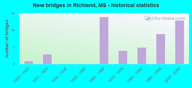
- New bridges - historical statistics
- 11920-1929
- 31930-1939
- 141960-1969
- 41970-1979
- 51980-1989
- 91990-1999
- 132000-2009


- Bridge Condition - Deck
- 23.3%Very good
- 33.3%Good
- 33.3%Satisfactory
- 10.0%Fair

- Bridge Condition - Superstructure
- 70.0%Very good
- 13.3%Good
- 10.0%Satisfactory
- 3.3%Fair
- 3.3%Poor

- Bridge Condition - Substructure
- 50.0%Very good
- 23.3%Good
- 16.7%Satisfactory
- 10.0%Fair

- Bridge Condition - Channel
- 38.1%Very good
- 33.3%Good
- 9.5%Satisfactory
- 19.0%Fair

- Bridge Condition - Culverts
- 66.7%Very good
- 33.3%Good
Find on map >> Show street view
Structure Number: 11000200610472A, Location: 0.6 MI W US 49 (Lat: 32.275067, Lng: -90.168542), Route carried "on" structure: Interstate 20, Year Built: 1967, Year Reconstructed: 1997, Status: Open, Structure Length: 12.71m (41.70ft), Average Daily Traffic: 25,000 (year 2020), Truck Traffic: 24%, Average Future Daily Traffic: 29,500 (year 2040), Design Load: HS 20, Features Intersected: OLD US 49
Minimum Vertical Clearance: 30+ m (98+ ft), Kilometerpoint: 42.825, Lanes on structure: 3, Lanes under structure: 2, Base Highway Network: Yes (Inventory Route: 2, Subroute: 1), Owner: State Highway Agency, Approaching Roadway Width: 15.2m (49.9ft), Skew: 30 degrees, Material/Design: Steel, Design/Construction: Stringer/Multi-beam, Number Of Spans In Main Unit: 1, Number Of Approach Spans: 6, Length of Maximum Span: 18.3m (60.0ft), Curb-To-Curb Width: 15.2m (49.9ft), Out-to-Out Width: 16.1m (52.8ft)
Condition: Deck: Good, Superstructure: Good, Substructure: Good, Operating Rating: 52.2 metric tons, Method Used To Determine Operating Rating: Load Factor (LF), Inventory Rating: 19.8 metric tons, Method Used To Determine Inventory Rating: Load Factor (LF), Structural Evaluation: Somewhat better than minimum adequacy, Deck Geometry: Meets minimum limits, Underclear: Meets minimum limits, Approach Roadway Alignment: Equal to present desirable criteria, Length Of Structure Improvement: 12.71m (41.70ft), Designated Inspection Frequency: Every 24 months, Inspection Date: November 2020, Bridge Improvement Cost: $237,000,000, Roadway Improvement Cost: $200,000,000, Total Project Cost: $437,000,000, Deck Structure Type: Concrete Cast-file-Place
Find on map >> Show street view
Structure Number: 11000200610472B, Location: 0.6 MI W US 49 (Lat: 32.274567, Lng: -90.170008), Route carried "on" structure: Ramp Interstate 20, Year Built: 1967, Year Reconstructed: 1997, Status: Open, Structure Length: 11.64m (38.19ft), Average Daily Traffic: 11,500 (year 2020), Truck Traffic: 18%, Average Future Daily Traffic: 13,000 (year 2040), Design Load: HS 20, Features Intersected: OLD US 49
Minimum Vertical Clearance: 30+ m (98+ ft), Kilometerpoint: 1.315, Lanes on structure: 3, Lanes under structure: 1, Owner: State Highway Agency, Approaching Roadway Width: 22.5m (73.8ft), Material/Design: Steel, Design/Construction: Stringer/Multi-beam, Number Of Spans In Main Unit: 1, Number Of Approach Spans: 6, Length of Maximum Span: 18.3m (60.0ft), Curb-To-Curb Width: 19.2m (63.0ft), Out-to-Out Width: 20.1m (65.9ft)
Condition: Deck: Satisfactory, Superstructure: Very good, Substructure: Very good, Operating Rating: 50.2 metric tons, Method Used To Determine Operating Rating: Load Factor (LF), Inventory Rating: 30.0 metric tons, Method Used To Determine Inventory Rating: Load Factor (LF), Structural Evaluation: Better than present minimum criteria, Deck Geometry: Superior to present desirable criteria, Underclear: Equal to present minimum criteria, Approach Roadway Alignment: Equal to present desirable criteria, Length Of Structure Improvement: 11.64m (38.19ft), Designated Inspection Frequency: Every 24 months, Inspection Date: November 2020, Bridge Improvement Cost: $217,000,000, Roadway Improvement Cost: $200,000,000, Total Project Cost: $417,000,000, Deck Structure Type: Concrete Cast-file-Place
Find on map >> Show street view
Structure Number: 11000200610472C, Location: 0.6 MI W US 49 (Lat: 32.275103, Lng: -90.169906), Route carried "on" structure: Interstate 20, Year Built: 1997, Status: Open, Structure Length: 12.71m (41.70ft), Average Daily Traffic: 25,000 (year 2020), Truck Traffic: 24%, Average Future Daily Traffic: 29,500 (year 2040), Design Load: HS 20, Features Intersected: OLD US 49
Minimum Vertical Clearance: 30+ m (98+ ft), Kilometerpoint: 0.774, Lanes on structure: 2, Lanes under structure: 2, Base Highway Network: Yes (Inventory Route: 2, Subroute: 1), Owner: State Highway Agency, Approaching Roadway Width: 14.6m (47.9ft), Material/Design: Prestressed concrete continuous, Design/Construction: Stringer/Multi-beam, Number Of Spans In Main Unit: 5, Number Of Approach Spans: 2, Length of Maximum Span: 18.3m (60.0ft), Curb-To-Curb Width: 14.6m (47.9ft), Out-to-Out Width: 15.5m (50.9ft)
Condition: Deck: Good, Superstructure: Very good, Substructure: Very good, Operating Rating: 53.0 metric tons, Method Used To Determine Operating Rating: Load Factor (LF), Inventory Rating: 31.7 metric tons, Method Used To Determine Inventory Rating: Load Factor (LF), Structural Evaluation: Better than present minimum criteria, Deck Geometry: Superior to present desirable criteria, Underclear: Somewhat better than minimum adequacy, Approach Roadway Alignment: Equal to present desirable criteria, Designated Inspection Frequency: Every 24 months, Inspection Date: November 2020, Deck Structure Type: Concrete Cast-file-Place
Find on map >> Show street view
Structure Number: 11000200610474A, Location: 0.4 MI W US 49 (Lat: 32.274489, Lng: -90.164803), Route carried "on" structure: Interstate 20, Year Built: 1967, Year Reconstructed: 1997, Status: Open, Structure Length: 12.86m (42.19ft), Average Daily Traffic: 25,000 (year 2020), Truck Traffic: 24%, Average Future Daily Traffic: 29,500 (year 2040), Design Load: HS 20, Features Intersected: KCS RR/COUNTY ROAD
Minimum Vertical Clearance: 30+ m (98+ ft), Kilometerpoint: 42.466, Lanes on structure: 2, Lanes under structure: 2, Base Highway Network: Yes (Inventory Route: 2, Subroute: 1), Owner: State Highway Agency, Approaching Roadway Width: 15.2m (49.9ft), Skew: 2 degrees, Material/Design: Prestressed concrete, Design/Construction: Stringer/Multi-beam, Number Of Spans In Main Unit: 3, Number Of Approach Spans: 4, Length of Maximum Span: 21.3m (69.9ft), Curb-To-Curb Width: 15.2m (49.9ft), Out-to-Out Width: 16.1m (52.8ft)
Condition: Deck: Fair, Superstructure: Very good, Substructure: Very good, Operating Rating: 49.7 metric tons, Method Used To Determine Operating Rating: Load Factor (LF), Inventory Rating: 29.8 metric tons, Method Used To Determine Inventory Rating: Load Factor (LF), Structural Evaluation: Better than present minimum criteria, Deck Geometry: Superior to present desirable criteria, Underclear: Equal to present minimum criteria, Approach Roadway Alignment: Equal to present desirable criteria, Length Of Structure Improvement: 12.86m (42.19ft), Designated Inspection Frequency: Every 24 months, Inspection Date: November 2020, Bridge Improvement Cost: $240,000,000, Roadway Improvement Cost: $200,000,000, Total Project Cost: $440,000,000, Deck Structure Type: Concrete Cast-file-Place
Find on map >> Show street view
Structure Number: 11000200610474B, Location: 0.4 MI W US 49 (Lat: 32.274131, Lng: -90.166011), Route carried "on" structure: Ramp Interstate 20, Year Built: 1967, Year Reconstructed: 1997, Status: Open, Structure Length: 12.86m (42.19ft), Average Daily Traffic: 8,000 (year 2020), Truck Traffic: 18%, Average Future Daily Traffic: 9,500 (year 2040), Design Load: HS 20, Features Intersected: KCS RR/COUNTY ROAD
Minimum Vertical Clearance: 30+ m (98+ ft), Kilometerpoint: 0.132, Lanes on structure: 2, Lanes under structure: 2, Owner: State Highway Agency, Approaching Roadway Width: 17.1m (56.1ft), Skew: 1 degrees, Material/Design: Prestressed concrete, Design/Construction: Stringer/Multi-beam, Number Of Spans In Main Unit: 3, Number Of Approach Spans: 4, Length of Maximum Span: 21.3m (69.9ft), Curb-To-Curb Width: 15.2m (49.9ft), Out-to-Out Width: 16.1m (52.8ft)
Condition: Deck: Fair, Superstructure: Very good, Substructure: Very good, Operating Rating: 49.7 metric tons, Method Used To Determine Operating Rating: Load Factor (LF), Inventory Rating: 29.8 metric tons, Method Used To Determine Inventory Rating: Load Factor (LF), Structural Evaluation: Better than present minimum criteria, Deck Geometry: Superior to present desirable criteria, Underclear: Equal to present minimum criteria, Approach Roadway Alignment: Equal to present desirable criteria, Length Of Structure Improvement: 12.86m (42.19ft), Designated Inspection Frequency: Every 24 months, Inspection Date: November 2020, Bridge Improvement Cost: $240,000,000, Roadway Improvement Cost: $200,000,000, Total Project Cost: $440,000,000, Deck Structure Type: Concrete Cast-file-Place
Find on map >> Show street view
Structure Number: 11000200610474C, Location: 0.4 MI W US 49 (Lat: 32.274492, Lng: -90.166067), Route carried "on" structure: Interstate 20, Year Built: 1997, Status: Open, Structure Length: 12.75m (41.83ft), Average Daily Traffic: 25,000 (year 2020), Truck Traffic: 24%, Average Future Daily Traffic: 29,500 (year 2040), Design Load: HS 20, Features Intersected: KCS RR/COUNTY ROAD
Minimum Vertical Clearance: 30+ m (98+ ft), Kilometerpoint: 1.143, Lanes on structure: 2, Lanes under structure: 2, Base Highway Network: Yes (Inventory Route: 2, Subroute: 1), Owner: State Highway Agency, Approaching Roadway Width: 14.6m (47.9ft), Skew: 10 degrees, Material/Design: Prestressed concrete continuous, Design/Construction: Stringer/Multi-beam, Number Of Spans In Main Unit: 3, Number Of Approach Spans: 4, Length of Maximum Span: 21.3m (69.9ft), Curb-To-Curb Width: 14.6m (47.9ft), Out-to-Out Width: 15.6m (51.2ft)
Condition: Deck: Very good, Superstructure: Very good, Substructure: Fair, Operating Rating: 46.3 metric tons, Method Used To Determine Operating Rating: Load Factor (LF), Inventory Rating: 27.8 metric tons, Method Used To Determine Inventory Rating: Load Factor (LF), Structural Evaluation: Somewhat better than minimum adequacy, Deck Geometry: Superior to present desirable criteria, Underclear: Better than present minimum criteria, Approach Roadway Alignment: Equal to present desirable criteria, Designated Inspection Frequency: Every 24 months, Inspection Date: November 2020, Deck Structure Type: Concrete Cast-file-Place
Find on map >> Show street view
Structure Number: 11000200610478A, Location: I 20 OVER US 49 (Lat: 32.272894, Lng: -90.157919), Route carried "on" structure: Interstate 20, Year Built: 1967, Year Reconstructed: 1997, Status: Open, Structure Length: 8.23m (27.00ft), Average Daily Traffic: 33,500 (year 2020), Truck Traffic: 16%, Average Future Daily Traffic: 39,000 (year 2040), Design Load: HS 20, Features Intersected: US 49
Minimum Vertical Clearance: 30+ m (98+ ft), Kilometerpoint: 41.793, Lanes on structure: 3, Lanes under structure: 5, Base Highway Network: Yes (Inventory Route: 2, Subroute: 1), Owner: State Highway Agency, Approaching Roadway Width: 18.9m (62.0ft), Material/Design: Prestressed concrete, Design/Construction: Stringer/Multi-beam, Number Of Spans In Main Unit: 4, Length of Maximum Span: 22.6m (74.1ft), Curb-To-Curb Width: 18.9m (62.0ft), Out-to-Out Width: 19.7m (64.6ft)
Condition: Deck: Good, Superstructure: Very good, Substructure: Very good, Operating Rating: 53.2 metric tons, Method Used To Determine Operating Rating: Load Factor (LF), Inventory Rating: 31.4 metric tons, Method Used To Determine Inventory Rating: Load Factor (LF), Structural Evaluation: Better than present minimum criteria, Deck Geometry: Superior to present desirable criteria, Underclear: High priority of corrective action, Approach Roadway Alignment: Equal to present desirable criteria, Designated Inspection Frequency: Every 24 months, Inspection Date: November 2020, Deck Structure Type: Concrete Cast-file-Place
Find on map >> Show street view
Structure Number: 11000200610478B, Location: I 20 OVER US 49 (Lat: 32.272922, Lng: -90.158775), Route carried "on" structure: Interstate 20, Year Built: 1967, Year Reconstructed: 1997, Status: Open, Structure Length: 8.23m (27.00ft), Average Daily Traffic: 33,500 (year 2020), Truck Traffic: 16%, Average Future Daily Traffic: 39,000 (year 2040), Design Load: HS 20, Features Intersected: US 49
Minimum Vertical Clearance: 30+ m (98+ ft), Kilometerpoint: 1.852, Lanes on structure: 4, Lanes under structure: 5, Base Highway Network: Yes (Inventory Route: 2, Subroute: 1), Owner: State Highway Agency, Approaching Roadway Width: 20.1m (65.9ft), Material/Design: Prestressed concrete, Design/Construction: Stringer/Multi-beam, Number Of Spans In Main Unit: 4, Length of Maximum Span: 22.6m (74.1ft), Curb-To-Curb Width: 20.1m (65.9ft), Out-to-Out Width: 21.0m (68.9ft)
Condition: Deck: Fair, Superstructure: Good, Substructure: Very good, Operating Rating: 53.3 metric tons, Method Used To Determine Operating Rating: Load Factor (LF), Inventory Rating: 31.6 metric tons, Method Used To Determine Inventory Rating: Load Factor (LF), Structural Evaluation: Better than present minimum criteria, Deck Geometry: Equal to present minimum criteria, Underclear: High priority of corrective action, Approach Roadway Alignment: Equal to present desirable criteria, Designated Inspection Frequency: Every 24 months, Inspection Date: November 2020, Deck Structure Type: Concrete Cast-file-Place
Find on map >> Show street view
Structure Number: 11000200610482, Location: 0.4 MI E US 49 (Lat: 32.270667, Lng: -90.152619), Route carried "on" structure: Interstate 20, Year Built: 1965, Status: Open, Structure Length: 1.04m (3.41ft), Average Daily Traffic: 67,000 (year 2020), Truck Traffic: 16%, Average Future Daily Traffic: 78,000 (year 2040), Design Load: HS 20, Features Intersected: CONWAY SLOUGH
Minimum Vertical Clearance: 30+ m (98+ ft), Kilometerpoint: 2.490, Lanes on structure: 8, Base Highway Network: Yes (Inventory Route: 2, Subroute: 1), Owner: State Highway Agency, Approaching Roadway Width: 26.8m (87.9ft), Skew: 11 degrees, Material/Design: Concrete, Design/Construction: Culvert, Number Of Spans In Main Unit: 3, Length of Maximum Span: 3.0m (9.8ft)
Condition: Channel: Very good, Culverts: Very good, Structural Evaluation: Equal to present desirable criteria, Waterway Adequacy: Equal to present desirable criteria, Approach Roadway Alignment: Equal to present desirable criteria, Length Of Structure Improvement: 1.04m (3.41ft), Designated Inspection Frequency: Every 24 months, Inspection Date: November 2020, Bridge Improvement Cost: $77,000,000, Roadway Improvement Cost: $200,000,000, Total Project Cost: $277,000,000
Find on map >> Show street view
Structure Number: 17000200610471A, Location: 0.6 MI W US 49 (Lat: 32.275094, Lng: -90.164936), Route carried "on" structure: Ramp Interstate 20, Year Built: 2006, Status: Open, Structure Length: 45.34m (148.75ft), Average Daily Traffic: 11,000 (year 2020), Truck Traffic: 18%, Average Future Daily Traffic: 12,000 (year 2040), Design Load: HS 20, Features Intersected: OLD US 49/KCS RR, Facility Carried by Structure: US 49 TO I 55 NB
Minimum Vertical Clearance: 30+ m (98+ ft), Kilometerpoint: 0.426, Lanes on structure: 2, Lanes under structure: 2, Owner: State Highway Agency, Approaching Roadway Width: 12.8m (42.0ft), Material/Design: Prestressed concrete continuous, Design/Construction: Stringer/Multi-beam, Number Of Spans In Main Unit: 17, Length of Maximum Span: 28.4m (93.2ft), Curb-To-Curb Width: 12.8m (42.0ft), Out-to-Out Width: 13.6m (44.6ft)
Condition: Deck: Good, Superstructure: Very good, Substructure: Very good, Operating Rating: 47.6 metric tons, Method Used To Determine Operating Rating: Load Factor (LF), Inventory Rating: 18.9 metric tons, Method Used To Determine Inventory Rating: Load Factor (LF), Structural Evaluation: Meets minimum limits, Deck Geometry: Superior to present desirable criteria, Underclear: Superior to present desirable criteria, Approach Roadway Alignment: Equal to present desirable criteria, Designated Inspection Frequency: Every 24 months, Inspection Date: November 2020, Deck Structure Type: Concrete Cast-file-Place
Find on map >> Show street view
Structure Number: 17000200610471B, Location: 0.6 MI W US 49 (Lat: 32.275561, Lng: -90.168400), Route carried "on" structure: Ramp Interstate 20, Year Built: 2006, Status: Open, Structure Length: 12.78m (41.93ft), Average Daily Traffic: 12,000 (year 2020), Truck Traffic: 18%, Average Future Daily Traffic: 15,000 (year 2040), Design Load: HS 20, Features Intersected: OLD US 49
Minimum Vertical Clearance: 5.01m (16.44ft), Kilometerpoint: 0.708, Lanes on structure: 2, Lanes under structure: 2, Owner: State Highway Agency, Approaching Roadway Width: 12.8m (42.0ft), Material/Design: Prestressed concrete, Design/Construction: Stringer/Multi-beam, Number Of Spans In Main Unit: 7, Length of Maximum Span: 22.9m (75.1ft), Curb-To-Curb Width: 12.8m (42.0ft), Out-to-Out Width: 13.6m (44.6ft)
Condition: Deck: Very good, Superstructure: Very good, Substructure: Very good, Operating Rating: 55.1 metric tons, Method Used To Determine Operating Rating: Load Factor (LF), Inventory Rating: 33.0 metric tons, Method Used To Determine Inventory Rating: Load Factor (LF), Structural Evaluation: Equal to present desirable criteria, Deck Geometry: Superior to present desirable criteria, Underclear: Equal to present desirable criteria, Approach Roadway Alignment: Equal to present desirable criteria, Designated Inspection Frequency: Every 24 months, Inspection Date: November 2020, Deck Structure Type: Concrete Cast-file-Place
Find on map >> Show street view
Structure Number: 17000200610471C, Location: 0.6 MI W US 49 (Lat: 32.275253, Lng: -90.166161), Route carried "on" structure: Ramp Interstate 20, Year Built: 2006, Status: Open, Structure Length: 34.94m (114.63ft), Average Daily Traffic: 11,000 (year 2020), Truck Traffic: 18%, Average Future Daily Traffic: 13,000 (year 2040), Design Load: HS 20, Features Intersected: I 20 WB TO I 55 NB RAMP
Minimum Vertical Clearance: 30+ m (98+ ft), Kilometerpoint: 0.209, Lanes on structure: 2, Lanes under structure: 2, Owner: State Highway Agency, Approaching Roadway Width: 12.8m (42.0ft), Material/Design: Steel, Design/Construction: Stringer/Multi-beam, Number Of Spans In Main Unit: 1, Number Of Approach Spans: 13, Length of Maximum Span: 31.4m (103.0ft), Curb-To-Curb Width: 12.8m (42.0ft), Out-to-Out Width: 13.6m (44.6ft)
Condition: Deck: Very good, Superstructure: Very good, Substructure: Very good, Operating Rating: 60.7 metric tons, Method Used To Determine Operating Rating: Load Factor (LF), Inventory Rating: 19.0 metric tons, Method Used To Determine Inventory Rating: Load Factor (LF), Structural Evaluation: Meets minimum limits, Deck Geometry: Superior to present desirable criteria, Underclear: Somewhat better than minimum adequacy, Approach Roadway Alignment: Equal to present desirable criteria, Designated Inspection Frequency: Every 24 months, Inspection Date: November 2020, Deck Structure Type: Concrete Cast-file-Place
Find on map >> Show street view
Structure Number: 17000200610473A, Location: 0.4 MI W US 49 (Lat: 32.274669, Lng: -90.164836), Route carried "on" structure: Ramp Interstate 20, Year Built: 2006, Status: Open, Structure Length: 13.09m (42.95ft), Average Daily Traffic: 12,000 (year 2020), Truck Traffic: 18%, Average Future Daily Traffic: 15,000 (year 2040), Design Load: HS 20, Features Intersected: KCS RR
Minimum Vertical Clearance: 7.05m (23.13ft), Kilometerpoint: 0.357, Lanes on structure: 2, Owner: State Highway Agency, Approaching Roadway Width: 12.8m (42.0ft), Skew: 2 degrees, Material/Design: Prestressed concrete, Design/Construction: Stringer/Multi-beam, Number Of Spans In Main Unit: 7, Length of Maximum Span: 21.6m (70.9ft), Curb-To-Curb Width: 12.8m (42.0ft), Out-to-Out Width: 13.6m (44.6ft)
Condition: Deck: Very good, Superstructure: Very good, Substructure: Very good, Operating Rating: 54.3 metric tons, Method Used To Determine Operating Rating: Load Factor (LF), Inventory Rating: 32.6 metric tons, Method Used To Determine Inventory Rating: Load Factor (LF), Structural Evaluation: Equal to present desirable criteria, Deck Geometry: Superior to present desirable criteria, Underclear: Equal to present minimum criteria, Approach Roadway Alignment: Equal to present desirable criteria, Designated Inspection Frequency: Every 24 months, Inspection Date: November 2020, Deck Structure Type: Concrete Cast-file-Place
Find on map >> Show street view
Structure Number: 17000200610474, Location: I 20 EAST TO US 49 SOUTH (Lat: 32.273886, Lng: -90.165947), Route carried "on" structure: Ramp Interstate 20, Year Built: 1997, Status: Open, Structure Length: 13.30m (43.64ft), Average Daily Traffic: 18,000 (year 2020), Truck Traffic: 7%, Average Future Daily Traffic: 18,000 (year 2040), Design Load: HS 20, Features Intersected: KCS RR/COUNTY ROAD
Minimum Vertical Clearance: 30+ m (98+ ft), Kilometerpoint: 0.204, Lanes on structure: 2, Owner: State Highway Agency, Approaching Roadway Width: 14.0m (45.9ft), Material/Design: Prestressed concrete continuous, Design/Construction: Stringer/Multi-beam, Number Of Spans In Main Unit: 3, Number Of Approach Spans: 4, Length of Maximum Span: 22.6m (74.1ft), Curb-To-Curb Width: 14.0m (45.9ft), Out-to-Out Width: 14.9m (48.9ft)
Condition: Deck: Very good, Superstructure: Very good, Substructure: Satisfactory, Operating Rating: 52.8 metric tons, Method Used To Determine Operating Rating: Load Factor (LF), Inventory Rating: 31.6 metric tons, Method Used To Determine Inventory Rating: Load Factor (LF), Structural Evaluation: Equal to present minimum criteria, Deck Geometry: Superior to present desirable criteria, Underclear: Equal to present minimum criteria, Approach Roadway Alignment: Equal to present desirable criteria, Designated Inspection Frequency: Every 24 months, Inspection Date: November 2020, Deck Structure Type: Concrete Cast-file-Place
Find on map >> Show street view
Structure Number: 21000490611536B, Location: 1.3 MI S I 20 (Lat: 32.245883, Lng: -90.163786), Route carried "on" structure: US 49, Year Built: 1965, Status: Open, Structure Length: 10.36m (33.99ft), Average Daily Traffic: 25,500 (year 2020), Truck Traffic: 10%, Average Future Daily Traffic: 25,500 (year 2040), Design Load: HS 20, Features Intersected: RICHLAND CREEK
Minimum Vertical Clearance: 30+ m (98+ ft), Kilometerpoint: 3.660, Lanes on structure: 2, Base Highway Network: Yes (Inventory Route: 4, Subroute: 1), Owner: State Highway Agency, Approaching Roadway Width: 13.4m (44.0ft), Material/Design: Prestressed concrete, Design/Construction: Stringer/Multi-beam, Number Of Spans In Main Unit: 3, Number Of Approach Spans: 4, Length of Maximum Span: 18.3m (60.0ft), Curb or Sidewalk Widths: Left: 0.5m (1.6ft), Right: 0.5m (1.6ft), Curb-To-Curb Width: 8.5m (27.9ft), Out-to-Out Width: 10.0m (32.8ft)
Condition: Deck: Satisfactory, Superstructure: Very good, Substructure: Satisfactory, Channel: Fair, Operating Rating: 61.4 metric tons, Method Used To Determine Operating Rating: Load Factor (LF), Inventory Rating: 34.0 metric tons, Method Used To Determine Inventory Rating: Load Factor (LF), Structural Evaluation: Equal to present minimum criteria, Deck Geometry: High priority of corrective action, Waterway Adequacy: Equal to present desirable criteria, Approach Roadway Alignment: Equal to present desirable criteria, Length Of Structure Improvement: 10.36m (33.99ft), Designated Inspection Frequency: Every 24 months, Inspection Date: November 2020, Bridge Improvement Cost: $155,000,000, Roadway Improvement Cost: $200,000,000, Total Project Cost: $411,000,000, Deck Structure Type: Concrete Cast-file-Place
Find on map >> Show street view
Structure Number: 21000490611536C, Location: 1.3 MI S I 20 (Lat: 32.244919, Lng: -90.163792), Route carried "on" structure: US 49, Year Built: 1965, Status: Open, Structure Length: 10.36m (33.99ft), Average Daily Traffic: 25,500 (year 2020), Truck Traffic: 10%, Average Future Daily Traffic: 25,500 (year 2040), Design Load: HS 20, Features Intersected: RICHLAND CREEK
Minimum Vertical Clearance: 30+ m (98+ ft), Kilometerpoint: 28.548, Lanes on structure: 2, Base Highway Network: Yes (Inventory Route: 4, Subroute: 1), Owner: State Highway Agency, Approaching Roadway Width: 13.4m (44.0ft), Material/Design: Prestressed concrete, Design/Construction: Stringer/Multi-beam, Number Of Spans In Main Unit: 3, Number Of Approach Spans: 4, Length of Maximum Span: 18.3m (60.0ft), Curb or Sidewalk Widths: Left: 0.5m (1.6ft), Right: 0.5m (1.6ft), Curb-To-Curb Width: 8.5m (27.9ft), Out-to-Out Width: 10.0m (32.8ft)
Condition: Deck: Satisfactory, Superstructure: Very good, Substructure: Very good, Channel: Fair, Operating Rating: 61.4 metric tons, Method Used To Determine Operating Rating: Load Factor (LF), Inventory Rating: 34.0 metric tons, Method Used To Determine Inventory Rating: Load Factor (LF), Structural Evaluation: Equal to present desirable criteria, Deck Geometry: High priority of corrective action, Waterway Adequacy: Equal to present desirable criteria, Approach Roadway Alignment: Equal to present desirable criteria, Length Of Structure Improvement: 10.36m (33.99ft), Designated Inspection Frequency: Every 24 months, Inspection Date: November 2020, Bridge Improvement Cost: $155,000,000, Roadway Improvement Cost: $200,000,000, Total Project Cost: $411,000,000, Deck Structure Type: Concrete Cast-file-Place
Find on map >> Show street view
Structure Number: 21000490611545, Location: 1.1 MI S I 20 (Lat: 32.256267, Lng: -90.160928), Route carried "on" structure: US 49, Year Built: 1970, Status: Open, Structure Length: 0.67m (2.20ft), Average Daily Traffic: 52,000 (year 2020), Truck Traffic: 14%, Average Future Daily Traffic: 52,000 (year 2040), Design Load: HS 15, Features Intersected: DITCH
Minimum Vertical Clearance: 30+ m (98+ ft), Kilometerpoint: 29.837, Lanes on structure: 8, Base Highway Network: Yes (Inventory Route: 4, Subroute: 1), Owner: State Highway Agency, Approaching Roadway Width: 13.4m (44.0ft), Material/Design: Concrete, Design/Construction: Culvert, Number Of Spans In Main Unit: 2, Length of Maximum Span: 3.0m (9.8ft)
Condition: Channel: Very good, Culverts: Very good, Operating Rating: 67.5 metric tons, Method Used To Determine Operating Rating: Load Factor (LF), Inventory Rating: 40.5 metric tons, Method Used To Determine Inventory Rating: Load Factor (LF), Structural Evaluation: Equal to present desirable criteria, Waterway Adequacy: Equal to present desirable criteria, Approach Roadway Alignment: Equal to present desirable criteria, Length Of Structure Improvement: 0.67m (2.20ft), Designated Inspection Frequency: Every 24 months, Inspection Date: November 2020, Bridge Improvement Cost: $50,000,000, Roadway Improvement Cost: $200,000,000, Total Project Cost: $290,000,000
Find on map >> Show street view
Structure Number: 2100049061155, Location: 0.6 MI S I 20 (Lat: 32.263586, Lng: -90.160597), Route carried "on" structure: US 49, Year Built: 2008, Status: Open, Structure Length: 8.28m (27.17ft), Average Daily Traffic: 52,000 (year 2020), Truck Traffic: 14%, Average Future Daily Traffic: 52,000 (year 2040), Design Load: HS 20, Features Intersected: KCS RR
Minimum Vertical Clearance: 30+ m (98+ ft), Kilometerpoint: 30.648, Lanes on structure: 8, Lanes under structure: 2, Base Highway Network: Yes (Inventory Route: 4, Subroute: 1), Owner: State Highway Agency, Approaching Roadway Width: 43.9m (144.0ft), Skew: 33 degrees, Material/Design: Prestressed concrete continuous, Design/Construction: Stringer/Multi-beam, Number Of Spans In Main Unit: 3, Length of Maximum Span: 29.0m (95.1ft), Curb-To-Curb Width: 43.9m (144.0ft), Out-to-Out Width: 48.5m (159.1ft)
Condition: Deck: Satisfactory, Superstructure: Very good, Substructure: Good, Operating Rating: 76.2 metric tons, Method Used To Determine Operating Rating: Load Factor (LF), Inventory Rating: 40.9 metric tons, Method Used To Determine Inventory Rating: Load Factor (LF), Structural Evaluation: Better than present minimum criteria, Deck Geometry: Superior to present desirable criteria, Underclear: Equal to present minimum criteria, Approach Roadway Alignment: Equal to present desirable criteria, Designated Inspection Frequency: Every 24 months, Inspection Date: November 2020, Deck Structure Type: Concrete Cast-file-Place
Find on map >> Show street view
Structure Number: 21000490611553, Location: 0.4 MI S I 20 (Lat: 32.266942, Lng: -90.160297), Route carried "on" structure: US 49, Year Built: 1967, Status: Open, Structure Length: 1.30m (4.27ft), Average Daily Traffic: 52,000 (year 2020), Truck Traffic: 14%, Average Future Daily Traffic: 52,000 (year 2040), Design Load: HS 20, Features Intersected: CONWAY SLOUGH
Minimum Vertical Clearance: 30+ m (98+ ft), Kilometerpoint: 31.022, Lanes on structure: 9, Base Highway Network: Yes (Inventory Route: 4, Subroute: 1), Owner: State Highway Agency, Approaching Roadway Width: 26.8m (87.9ft), Skew: 1 degrees, Material/Design: Concrete, Design/Construction: Culvert, Number Of Spans In Main Unit: 4, Length of Maximum Span: 3.0m (9.8ft)
Condition: Channel: Very good, Culverts: Very good, Inventory Rating: 66.2 metric tons, Method Used To Determine Inventory Rating: Load Factor (LF), Structural Evaluation: Equal to present desirable criteria, Waterway Adequacy: Better than present minimum criteria, Approach Roadway Alignment: Equal to present desirable criteria, Designated Inspection Frequency: Every 24 months, Inspection Date: November 2020
Find on map >> Show street view
Structure Number: 27000450380790B, Location: INT OF OLD NEW US 45 (Lat: 32.431808, Lng: -88.641097), Route carried "on" structure: Ramp US 45, Year Built: 1972, Status: Open, Structure Length: 0.88m (2.89ft), Average Daily Traffic: 560 (year 2020), Truck Traffic: 5%, Average Future Daily Traffic: 560 (year 2040), Design Load: HS 20, Features Intersected: SOWASHEE CREEK, Facility Carried by Structure: S RAMP OLD TO NEW
Minimum Vertical Clearance: 30+ m (98+ ft), Kilometerpoint: 0.124, Lanes on structure: 1, Owner: State Highway Agency, Approaching Roadway Width: 9.7m (31.8ft), Skew: 3 degrees, Material/Design: Concrete, Design/Construction: Culvert, Number Of Spans In Main Unit: 1, Length of Maximum Span: 6.7m (22.0ft)
Condition: Channel: Very good, Culverts: Very good, Structural Evaluation: Equal to present desirable criteria, Waterway Adequacy: Equal to present desirable criteria, Approach Roadway Alignment: Equal to present desirable criteria, Designated Inspection Frequency: Every 24 months, Inspection Date: March 2021
Find on map >> Show street view
Structure Number: 27000490611556, Location: US 49 OVER I 20 (Lat: 32.270539, Lng: -90.157361), Route carried "on" structure: Ramp US 49, Year Built: 2006, Status: Open, Structure Length: 59.65m (195.70ft), Average Daily Traffic: 17,000 (year 2020), Truck Traffic: 7%, Average Future Daily Traffic: 17,000 (year 2040), Design Load: HS 20, Features Intersected: I 20
Minimum Vertical Clearance: 6.04m (19.82ft), Kilometerpoint: 0.290, Lanes on structure: 2, Lanes under structure: 11, Owner: State Highway Agency, Approaching Roadway Width: 14.6m (47.9ft), Material/Design: Steel continuous, Design/Construction: Stringer/Multi-beam, Number Of Spans In Main Unit: 3, Number Of Approach Spans: 12, Length of Maximum Span: 60.4m (198.2ft), Curb-To-Curb Width: 14.6m (47.9ft), Out-to-Out Width: 15.5m (50.9ft)
Condition: Deck: Good, Superstructure: Very good, Substructure: Good, Operating Rating: 60.9 metric tons, Method Used To Determine Operating Rating: Load Factor (LF), Inventory Rating: 33.9 metric tons, Method Used To Determine Inventory Rating: Load Factor (LF), Structural Evaluation: Better than present minimum criteria, Deck Geometry: Superior to present desirable criteria, Underclear: Superior to present desirable criteria, Approach Roadway Alignment: Better than present minimum criteria, Designated Inspection Frequency: Every 24 months, Inspection Date: July 2021, Deck Structure Type: Concrete Cast-file-Place
Find on map >> Show street view
Structure Number: 28000490180683, Location: 0.3 MI S US 11 (Lat: 31.305714, Lng: -89.314194), Route carried "on" structure: ServiceOther road 49, Year Built: 2002, Status: Open, Structure Length: 1.74m (5.71ft), Average Daily Traffic: 1,100 (year 2020), Truck Traffic: 4%, Average Future Daily Traffic: 1,100 (year 2040), Design Load: HS 20, Features Intersected: GORDONS CREEK
Minimum Vertical Clearance: 30+ m (98+ ft), Kilometerpoint: 0.536, Lanes on structure: 2, Owner: State Highway Agency, Approaching Roadway Width: 8.5m (27.9ft), Material/Design: Concrete, Design/Construction: Channel Beam, Number Of Spans In Main Unit: 3, Length of Maximum Span: 5.8m (19.0ft), Curb-To-Curb Width: 8.5m (27.9ft), Out-to-Out Width: 9.3m (30.5ft)
Condition: Deck: Very good, Superstructure: Very good, Substructure: Good, Channel: Satisfactory, Operating Rating: 48.0 metric tons, Method Used To Determine Operating Rating: Load Factor (LF), Inventory Rating: 28.8 metric tons, Method Used To Determine Inventory Rating: Load Factor (LF), Structural Evaluation: Better than present minimum criteria, Deck Geometry: Somewhat better than minimum adequacy, Waterway Adequacy: Better than present minimum criteria, Approach Roadway Alignment: Better than present minimum criteria, Designated Inspection Frequency: Every 24 months, Inspection Date: Febuary 2020, Deck Structure Type: Concrete Precast Panels
Find on map >> Show street view
Structure Number: 28000490611536A, Location: 1.3 MI S I 20 (Lat: 32.245044, Lng: -90.164311), Route carried "on" structure: ServiceOther road 49, Year Built: 1970, Status: Open, Structure Length: 10.36m (33.99ft), Average Daily Traffic: 540 (year 2020), Truck Traffic: 4%, Average Future Daily Traffic: 540 (year 2040), Design Load: HS 20, Features Intersected: RICHLAND CREEK
Minimum Vertical Clearance: 30+ m (98+ ft), Kilometerpoint: 0.591, Lanes on structure: 2, Owner: State Highway Agency, Approaching Roadway Width: 10.4m (34.1ft), Material/Design: Prestressed concrete, Design/Construction: Stringer/Multi-beam, Number Of Spans In Main Unit: 3, Number Of Approach Spans: 4, Length of Maximum Span: 18.3m (60.0ft), Curb or Sidewalk Widths: Left: 0.5m (1.6ft), Right: 0.5m (1.6ft), Curb-To-Curb Width: 8.5m (27.9ft), Out-to-Out Width: 10.0m (32.8ft)
Condition: Deck: Satisfactory, Superstructure: Very good, Substructure: Very good, Channel: Good, Operating Rating: 64.6 metric tons, Method Used To Determine Operating Rating: Load Factor (LF), Inventory Rating: 38.6 metric tons, Method Used To Determine Inventory Rating: Load Factor (LF), Structural Evaluation: Equal to present desirable criteria, Deck Geometry: Somewhat better than minimum adequacy, Waterway Adequacy: Equal to present desirable criteria, Approach Roadway Alignment: Equal to present desirable criteria, Designated Inspection Frequency: Every 24 months, Inspection Date: November 2020, Deck Structure Type: Concrete Cast-file-Place
Find on map >> Show street view
Structure Number: 28000490611536D, Location: 1.3 MI S I 20 (Lat: 32.245792, Lng: -90.163297), Route carried "on" structure: ServiceOther road 49, Year Built: 1970, Status: Open, Structure Length: 10.36m (33.99ft), Average Daily Traffic: 1,700 (year 2020), Truck Traffic: 4%, Average Future Daily Traffic: 1,700 (year 2040), Design Load: HS 20, Features Intersected: RICHLAND CREEK
Minimum Vertical Clearance: 30+ m (98+ ft), Kilometerpoint: 2.045, Lanes on structure: 2, Owner: State Highway Agency, Approaching Roadway Width: 10.4m (34.1ft), Material/Design: Prestressed concrete, Design/Construction: Stringer/Multi-beam, Number Of Spans In Main Unit: 3, Number Of Approach Spans: 4, Length of Maximum Span: 18.3m (60.0ft), Curb or Sidewalk Widths: Left: 0.5m (1.6ft), Right: 0.5m (1.6ft), Curb-To-Curb Width: 8.5m (27.9ft), Out-to-Out Width: 10.0m (32.8ft)
Condition: Deck: Satisfactory, Superstructure: Very good, Substructure: Very good, Channel: Fair, Operating Rating: 70.6 metric tons, Method Used To Determine Operating Rating: Load Factor (LF), Inventory Rating: 42.8 metric tons, Method Used To Determine Inventory Rating: Load Factor (LF), Structural Evaluation: Equal to present desirable criteria, Deck Geometry: Somewhat better than minimum adequacy, Waterway Adequacy: Meets minimum limits, Approach Roadway Alignment: Equal to present minimum criteria, Designated Inspection Frequency: Every 24 months, Inspection Date: November 2020, Deck Structure Type: Concrete Cast-file-Place
Find on map >> Show street view
Structure Number: SA610000000005, Location: SEC 11 T 4N R 1E B (Lat: 32.213386, Lng: -90.163400), Route carried "on" structure: County highway 6968, Year Built: 1982, Status: Open, Structure Length: 1.07m (3.51ft), Average Daily Traffic: 5,600 (year 2020), Truck Traffic: 15%, Average Future Daily Traffic: 8,400 (year 2040), Design Load: HS 20, Features Intersected: DITCH, Facility Carried by Structure: OLD HWY 49
Minimum Vertical Clearance: 30+ m (98+ ft), Kilometerpoint: 6.276, Lanes on structure: 2, Owner: City or Municipal Highway Agency, Approaching Roadway Width: 6.7m (22.0ft), Skew: 1 degrees, Material/Design: Prestressed concrete, Design/Construction: Slab, Number Of Spans In Main Unit: 1, Length of Maximum Span: 10.7m (35.1ft), Curb or Sidewalk Widths: Left: 0.3m (1.0ft), Right: 0.3m (1.0ft), Curb-To-Curb Width: 7.9m (25.9ft), Out-to-Out Width: 8.5m (27.9ft)
Condition: Deck: Very good, Superstructure: Very good, Substructure: Very good, Channel: Very good, Operating Rating: 32.7 metric tons, Method Used To Determine Operating Rating: Field evaluation and documented engineering judgment, Inventory Rating: 19.6 metric tons, Method Used To Determine Inventory Rating: Field evaluation and documented engineering judgment, Structural Evaluation: Meets minimum limits, Deck Geometry: High priority of replacement, Waterway Adequacy: Better than present minimum criteria, Approach Roadway Alignment: Equal to present desirable criteria, Length Of Structure Improvement: 1.74m (5.71ft), Designated Inspection Frequency: Every 24 months, Inspection Date: November 2020, Bridge Improvement Cost: $103,000, Roadway Improvement Cost: $10,000, Total Project Cost: $127,000 ( Estimate for 2020), Deck Structure Type: Concrete Cast-file-Place, Wearing Surface/Protective System: Wearing Surface: Bituminous
Find on map >> Show street view
Structure Number: SA6100000000074, Location: SEC 23 T 5N R 1E B (Lat: 32.256103, Lng: -90.173242), Route carried "on" structure: County highway 7325, Year Built: 1939, Status: Open, Structure Length: 9.14m (29.99ft), Average Daily Traffic: 5,600 (year 2021), Truck Traffic: 10%, Average Future Daily Traffic: 8,400 (year 2041), Design Load: H 15, Features Intersected: RICHLAND CREEK, Facility Carried by Structure: OLD HWY 49
Minimum Vertical Clearance: 30+ m (98+ ft), Kilometerpoint: 1.931, Lanes on structure: 2, Owner: City or Municipal Highway Agency, Approaching Roadway Width: 7.3m (24.0ft), Material/Design: Steel, Design/Construction: Stringer/Multi-beam, Number Of Spans In Main Unit: 1, Number Of Approach Spans: 8, Length of Maximum Span: 18.3m (60.0ft), Curb or Sidewalk Widths: Left: 1.3m (4.3ft), Right: 1.3m (4.3ft), Curb-To-Curb Width: 7.3m (24.0ft), Out-to-Out Width: 10.6m (34.8ft)
Condition: Deck: Good, Superstructure: Poor, Substructure: Satisfactory, Channel: Fair, Operating Rating: 28.7 metric tons, Method Used To Determine Operating Rating: Load Factor (LF), Inventory Rating: 17.3 metric tons, Method Used To Determine Inventory Rating: Load Factor (LF), Structural Evaluation: Meets minimum limits, Deck Geometry: High priority of replacement, Waterway Adequacy: Equal to present desirable criteria, Approach Roadway Alignment: Equal to present desirable criteria, Bridge Posting: Required (Relationship of Operating Rating to Maximum Legal Load: 20.0 - 29.9% below), Length Of Structure Improvement: 11.89m (39.01ft), Designated Inspection Frequency: Every 12 months, Inspection Date: October 2021, Bridge Improvement Cost: $710,000, Roadway Improvement Cost: $70,000, Total Project Cost: $874,000 ( Estimate for 2020), Deck Structure Type: Concrete Cast-file-Place, Wearing Surface/Protective System: Wearing Surface: Bituminous
Find on map >> Show street view
Structure Number: SA6100000000075, Location: SEC 23 T 5N R 1E B (Lat: 32.263244, Lng: -90.172492), Route carried "on" structure: County highway 7325, Year Built: 1939, Status: Posted for load, Structure Length: 4.57m (14.99ft), Average Daily Traffic: 5,200 (year 2020), Truck Traffic: 10%, Average Future Daily Traffic: 7,800 (year 2040), Design Load: H 20, Features Intersected: RICHLAND CK RELIEF, Facility Carried by Structure: OLD HWY 49
Minimum Vertical Clearance: 30+ m (98+ ft), Kilometerpoint: 2.735, Lanes on structure: 2, Owner: City or Municipal Highway Agency, Approaching Roadway Width: 6.7m (22.0ft), Material/Design: Concrete, Design/Construction: Tee Beam, Number Of Spans In Main Unit: 5, Length of Maximum Span: 9.1m (29.9ft), Curb or Sidewalk Widths: Left: 1.3m (4.3ft), Right: 1.3m (4.3ft), Curb-To-Curb Width: 7.3m (24.0ft), Out-to-Out Width: 10.6m (34.8ft)
Condition: Deck: Satisfactory, Superstructure: Satisfactory, Substructure: Satisfactory, Channel: Very good, Operating Rating: 35.3 metric tons, Method Used To Determine Operating Rating: Load Factor (LF), Inventory Rating: 21.2 metric tons, Method Used To Determine Inventory Rating: Load Factor (LF), Structural Evaluation: Somewhat better than minimum adequacy, Deck Geometry: High priority of replacement, Waterway Adequacy: Equal to present desirable criteria, Approach Roadway Alignment: Equal to present desirable criteria, Bridge Posting: Required (Relationship of Operating Rating to Maximum Legal Load: 10.0 - 19.9% below), Length Of Structure Improvement: 4.88m (16.01ft), Designated Inspection Frequency: Every 24 months, Inspection Date: November 2020, Bridge Improvement Cost: $291,000, Roadway Improvement Cost: $30,000, Total Project Cost: $359,000 ( Estimate for 2020), Deck Structure Type: Concrete Cast-file-Place, Wearing Surface/Protective System: Wearing Surface: Bituminous
Find on map >> Show street view
Structure Number: SA6100000000076, Location: SEC 23 T 5N R 1E B (Lat: 32.267700, Lng: -90.171417), Route carried "on" structure: County highway 7325, Year Built: 1939, Status: Posted for load, Structure Length: 4.57m (14.99ft), Average Daily Traffic: 5,200 (year 2020), Truck Traffic: 8%, Average Future Daily Traffic: 7,800 (year 2040), Design Load: H 20, Features Intersected: CONWAY SLOUGH, Facility Carried by Structure: OLD HWY 49
Minimum Vertical Clearance: 30+ m (98+ ft), Kilometerpoint: 3.218, Lanes on structure: 2, Owner: City or Municipal Highway Agency, Approaching Roadway Width: 6.7m (22.0ft), Material/Design: Concrete, Design/Construction: Tee Beam, Number Of Spans In Main Unit: 5, Length of Maximum Span: 9.1m (29.9ft), Curb or Sidewalk Widths: Left: 1.3m (4.3ft), Right: 1.3m (4.3ft), Curb-To-Curb Width: 7.3m (24.0ft), Out-to-Out Width: 10.6m (34.8ft)
Condition: Deck: Satisfactory, Superstructure: Satisfactory, Substructure: Satisfactory, Channel: Satisfactory, Operating Rating: 35.3 metric tons, Method Used To Determine Operating Rating: Load Factor (LF), Inventory Rating: 21.2 metric tons, Method Used To Determine Inventory Rating: Load Factor (LF), Structural Evaluation: Somewhat better than minimum adequacy, Deck Geometry: High priority of replacement, Waterway Adequacy: Equal to present desirable criteria, Approach Roadway Alignment: Equal to present desirable criteria, Bridge Posting: Required (Relationship of Operating Rating to Maximum Legal Load: 10.0 - 19.9% below), Length Of Structure Improvement: 4.88m (16.01ft), Designated Inspection Frequency: Every 24 months, Inspection Date: November 2020, Bridge Improvement Cost: $291,000, Roadway Improvement Cost: $30,000, Total Project Cost: $359,000 ( Estimate for 2020), Deck Structure Type: Concrete Cast-file-Place, Wearing Surface/Protective System: Wearing Surface: Bituminous
Find on map >> Show street view
Structure Number: SA6100000000077, Location: SEC 26 T 5N R 1E B (Lat: 32.242639, Lng: -90.167722), Route carried "on" structure: County highway 7325, Year Built: 1928, Status: Open, Structure Length: 1.04m (3.41ft), Average Daily Traffic: 5,600 (year 2020), Truck Traffic: 15%, Average Future Daily Traffic: 8,400 (year 2040), Design Load: HS 15, Features Intersected: DITCH, Facility Carried by Structure: OLD HWY 49
Minimum Vertical Clearance: 30+ m (98+ ft), Kilometerpoint: 0.482, Lanes on structure: 2, Owner: City or Municipal Highway Agency, Approaching Roadway Width: 7.3m (24.0ft), Material/Design: Concrete, Design/Construction: Culvert, Number Of Spans In Main Unit: 4, Length of Maximum Span: 3.0m (9.8ft)
Condition: Channel: Good, Culverts: Good, Operating Rating: 34.6 metric tons, Method Used To Determine Operating Rating: Load Factor (LF), Inventory Rating: 20.6 metric tons, Method Used To Determine Inventory Rating: Load Factor (LF), Structural Evaluation: Somewhat better than minimum adequacy, Waterway Adequacy: Better than present minimum criteria, Approach Roadway Alignment: Equal to present desirable criteria, Length Of Structure Improvement: 1.74m (5.71ft), Designated Inspection Frequency: Every 24 months, Inspection Date: November 2020, Bridge Improvement Cost: $103,000, Roadway Improvement Cost: $10,000, Total Project Cost: $127,000 ( Estimate for 2020)
Find on map >> Show street view
Structure Number: SA6100000000078, Location: SEC 35 T 5N R 1E B (Lat: 32.237806, Lng: -90.168278), Route carried "on" structure: City street 6968, Year Built: 1999, Status: Open, Structure Length: 1.89m (6.20ft), Average Daily Traffic: 5,600 (year 2020), Truck Traffic: 8%, Average Future Daily Traffic: 8,400 (year 2040), Design Load: H 15, Features Intersected: SQUIRREL BRANCH, Facility Carried by Structure: OLD HWY 49
Minimum Vertical Clearance: 30+ m (98+ ft), Kilometerpoint: 9.012, Lanes on structure: 2, Owner: City or Municipal Highway Agency, Approaching Roadway Width: 6.4m (21.0ft), Material/Design: Concrete, Design/Construction: Channel Beam, Number Of Spans In Main Unit: 2, Length of Maximum Span: 9.4m (30.8ft), Curb or Sidewalk Widths: Left: 0.2m (0.7ft), Right: 0.2m (0.7ft), Curb-To-Curb Width: 7.1m (23.3ft), Out-to-Out Width: 7.5m (24.6ft)
Condition: Deck: Satisfactory, Superstructure: Satisfactory, Substructure: Good, Channel: Good, Operating Rating: 55.2 metric tons, Method Used To Determine Operating Rating: Load Factor (LF), Inventory Rating: 33.0 metric tons, Method Used To Determine Inventory Rating: Load Factor (LF), Structural Evaluation: Equal to present minimum criteria, Deck Geometry: High priority of replacement, Waterway Adequacy: Better than present minimum criteria, Approach Roadway Alignment: Equal to present desirable criteria, Length Of Structure Improvement: 2.83m (9.28ft), Designated Inspection Frequency: Every 24 months, Inspection Date: November 2020, Bridge Improvement Cost: $169,000, Roadway Improvement Cost: $20,000, Total Project Cost: $212,000 ( Estimate for 2020), Deck Structure Type: Concrete Precast Panels, Wearing Surface/Protective System: Wearing Surface: Monolithic Concrete
Find on map >> Show street view
Structure Number: SA6100000000079, Location: SEC 36 T 5N R 1E (Lat: 32.228333, Lng: -90.153972), Route carried "on" structure: County highway 7256, Year Built: 2003, Status: Posted for load, Structure Length: 1.74m (5.71ft), Average Daily Traffic: 960 (year 2021), Truck Traffic: 8%, Average Future Daily Traffic: 1,440 (year 2041), Design Load: H 15, Features Intersected: SQUIRREL BRANCH, Facility Carried by Structure: LOWE CIR.
Minimum Vertical Clearance: 30+ m (98+ ft), Kilometerpoint: 0.482, Lanes on structure: 2, Owner: City or Municipal Highway Agency, Approaching Roadway Width: 7.9m (25.9ft), Material/Design: Concrete, Design/Construction: Channel Beam, Number Of Spans In Main Unit: 3, Length of Maximum Span: 5.8m (19.0ft), Curb or Sidewalk Widths: Left: 0.2m (0.7ft), Right: 0.2m (0.7ft), Curb-To-Curb Width: 8.1m (26.6ft), Out-to-Out Width: 8.5m (27.9ft)
Condition: Deck: Satisfactory, Superstructure: Fair, Substructure: Fair, Channel: Good, Operating Rating: 25.3 metric tons, Method Used To Determine Operating Rating: Load Factor (LF), Inventory Rating: 15.2 metric tons, Method Used To Determine Inventory Rating: Load Factor (LF), Structural Evaluation: Meets minimum limits, Deck Geometry: Somewhat better than minimum adequacy, Waterway Adequacy: Equal to present minimum criteria, Approach Roadway Alignment: Equal to present desirable criteria, Bridge Posting: Required (Relationship of Operating Rating to Maximum Legal Load: 30.0 - 39.9% below), Length Of Structure Improvement: 2.10m (6.89ft), Designated Inspection Frequency: Every 24 months, Inspection Date: November 2021, Bridge Improvement Cost: $125,000, Roadway Improvement Cost: $15,000, Total Project Cost: $156,000 ( Estimate for 2021), Deck Structure Type: Concrete Precast Panels, Wearing Surface/Protective System: Wearing Surface: Monolithic Concrete
Find on map >> Show street view
Structure Number: SA6100000000186, Location: SEC 1 T 4N R 1E (Lat: 32.220972, Lng: -90.158333), Route carried "on" structure: City street 7270, Year Built: 1988, Status: Open, Structure Length: 0.94m (3.08ft), Average Daily Traffic: 250 (year 2021), Truck Traffic: 8%, Average Future Daily Traffic: 375 (year 2041), Design Load: HS 20, Features Intersected: DITCH, Facility Carried by Structure: GREENVIEW PLACE
Minimum Vertical Clearance: 30+ m (98+ ft), Kilometerpoint: 0.643, Lanes on structure: 2, Owner: City or Municipal Highway Agency, Approaching Roadway Width: 8.1m (26.6ft), Material/Design: Concrete, Design/Construction: Channel Beam, Number Of Spans In Main Unit: 1, Length of Maximum Span: 9.4m (30.8ft), Curb or Sidewalk Widths: Left: 0.2m (0.7ft), Right: 0.2m (0.7ft), Curb-To-Curb Width: 8.1m (26.6ft), Out-to-Out Width: 8.5m (27.9ft)
Condition: Deck: Good, Superstructure: Very good, Substructure: Very good, Channel: Very good, Operating Rating: 75.5 metric tons, Method Used To Determine Operating Rating: Load Factor (LF), Inventory Rating: 45.4 metric tons, Method Used To Determine Inventory Rating: Load Factor (LF), Structural Evaluation: Equal to present desirable criteria, Deck Geometry: Somewhat better than minimum adequacy, Waterway Adequacy: Equal to present desirable criteria, Approach Roadway Alignment: Equal to present desirable criteria, Designated Inspection Frequency: Every 24 months, Inspection Date: November 2021, Deck Structure Type: Concrete Precast Panels, Wearing Surface/Protective System: Wearing Surface: Monolithic Concrete
Find on map >> Show street view
Structure Number: SA6100000000187, Location: SEC 2 T 4N R 1E (Lat: 32.220917, Lng: -90.162972), Route carried "on" structure: City street 7280, Year Built: 1988, Status: Open, Structure Length: 0.94m (3.08ft), Average Daily Traffic: 60 (year 2021), Average Future Daily Traffic: 90 (year 2041), Design Load: HS 20, Features Intersected: DITCH, Facility Carried by Structure: LAKELAND LANE
Minimum Vertical Clearance: 30+ m (98+ ft), Kilometerpoint: 0.160, Lanes on structure: 2, Owner: City or Municipal Highway Agency, Approaching Roadway Width: 8.1m (26.6ft), Material/Design: Concrete, Design/Construction: Channel Beam, Number Of Spans In Main Unit: 1, Length of Maximum Span: 9.4m (30.8ft), Curb or Sidewalk Widths: Left: 0.2m (0.7ft), Right: 0.2m (0.7ft), Curb-To-Curb Width: 8.1m (26.6ft), Out-to-Out Width: 8.5m (27.9ft)
Condition: Deck: Good, Superstructure: Very good, Substructure: Good, Channel: Very good, Operating Rating: 75.5 metric tons, Method Used To Determine Operating Rating: Load Factor (LF), Inventory Rating: 45.4 metric tons, Method Used To Determine Inventory Rating: Load Factor (LF), Structural Evaluation: Better than present minimum criteria, Deck Geometry: Equal to present minimum criteria, Waterway Adequacy: Equal to present desirable criteria, Approach Roadway Alignment: Equal to present desirable criteria, Designated Inspection Frequency: Every 24 months, Inspection Date: November 2021, Deck Structure Type: Concrete Precast Panels, Wearing Surface/Protective System: Wearing Surface: Monolithic Concrete
Find on map >> Show street view
Structure Number: SA6100000000189, Location: SEC 1 T 4N R 1E (Lat: 32.212306, Lng: -90.150778), Route carried "on" structure: City street 2012, Year Built: 1999, Status: Open, Structure Length: 1.89m (6.20ft), Average Daily Traffic: 300 (year 2021), Truck Traffic: 8%, Average Future Daily Traffic: 450 (year 2041), Design Load: HS 20, Features Intersected: DITCH, Facility Carried by Structure: RICHLAND SCHOOL DR
Minimum Vertical Clearance: 30+ m (98+ ft), Kilometerpoint: 0.053, Lanes on structure: 2, Owner: City or Municipal Highway Agency, Approaching Roadway Width: 8.5m (27.9ft), Material/Design: Concrete, Design/Construction: Channel Beam, Number Of Spans In Main Unit: 2, Length of Maximum Span: 9.4m (30.8ft), Curb or Sidewalk Widths: Left: 0.5m (1.6ft), Right: 0.5m (1.6ft), Curb-To-Curb Width: 8.5m (27.9ft), Out-to-Out Width: 9.5m (31.2ft)
Condition: Deck: Good, Superstructure: Good, Substructure: Good, Channel: Good, Operating Rating: 63.1 metric tons, Method Used To Determine Operating Rating: Load Factor (LF), Inventory Rating: 37.9 metric tons, Method Used To Determine Inventory Rating: Load Factor (LF), Structural Evaluation: Better than present minimum criteria, Deck Geometry: Equal to present minimum criteria, Waterway Adequacy: Equal to present desirable criteria, Approach Roadway Alignment: Equal to present desirable criteria, Designated Inspection Frequency: Every 24 months, Inspection Date: November 2021, Deck Structure Type: Concrete Precast Panels, Wearing Surface/Protective System: Wearing Surface: Monolithic Concrete
Find on map >> Show street view
Structure Number: SA6100000000197, Location: SEC 36 T 5N R 1E (Lat: 32.232056, Lng: -90.158056), Route carried "on" structure: City street 3902, Year Built: 1980, Status: Open, Structure Length: 0.94m (3.08ft), Average Daily Traffic: 60 (year 2021), Average Future Daily Traffic: 90 (year 2041), Design Load: H 15, Features Intersected: SQUIRREL BRANCH, Facility Carried by Structure: QUINN DRIVE
Minimum Vertical Clearance: 30+ m (98+ ft), Kilometerpoint: 0.186, Lanes on structure: 2, Owner: City or Municipal Highway Agency, Approaching Roadway Width: 7.0m (23.0ft), Material/Design: Concrete, Design/Construction: Channel Beam, Number Of Spans In Main Unit: 1, Length of Maximum Span: 9.4m (30.8ft), Curb or Sidewalk Widths: Left: 0.2m (0.7ft), Right: 0.2m (0.7ft), Curb-To-Curb Width: 7.1m (23.3ft), Out-to-Out Width: 7.5m (24.6ft)
Condition: Deck: Good, Superstructure: Good, Substructure: Fair, Channel: Good, Operating Rating: 55.2 metric tons, Method Used To Determine Operating Rating: Load Factor (LF), Inventory Rating: 33.0 metric tons, Method Used To Determine Inventory Rating: Load Factor (LF), Structural Evaluation: Somewhat better than minimum adequacy, Deck Geometry: Somewhat better than minimum adequacy, Waterway Adequacy: Equal to present desirable criteria, Approach Roadway Alignment: Equal to present desirable criteria, Length Of Structure Improvement: 1.74m (5.71ft), Designated Inspection Frequency: Every 24 months, Inspection Date: November 2021, Bridge Improvement Cost: $103,000, Roadway Improvement Cost: $10,000, Total Project Cost: $127,000 ( Estimate for 2021), Deck Structure Type: Concrete Precast Panels, Wearing Surface/Protective System: Wearing Surface: Monolithic Concrete
Find on map >> Show street view
Structure Number: SA6100000000198, Location: SEC 1 T 4N R 1E (Lat: 32.212861, Lng: -90.157056), Route carried "on" structure: City street 3901, Year Built: 1980, Status: Open, Structure Length: 0.93m (3.05ft), Average Daily Traffic: 3,100 (year 2021), Truck Traffic: 8%, Average Future Daily Traffic: 4,650 (year 2041), Design Load: HS 20, Features Intersected: DITCH, Facility Carried by Structure: INDUSTRIAL DRIVE
Minimum Vertical Clearance: 30+ m (98+ ft), Kilometerpoint: 0.965, Lanes on structure: 2, Owner: City or Municipal Highway Agency, Approaching Roadway Width: 7.5m (24.6ft), Skew: 4 degrees, Material/Design: Concrete, Design/Construction: Culvert, Number Of Spans In Main Unit: 2, Length of Maximum Span: 3.0m (9.8ft)
Condition: Channel: Good, Culverts: Good, Operating Rating: 98.0 metric tons, Method Used To Determine Operating Rating: Load Factor (LF), Inventory Rating: 70.6 metric tons, Method Used To Determine Inventory Rating: Load Factor (LF), Structural Evaluation: Better than present minimum criteria, Waterway Adequacy: Equal to present desirable criteria, Approach Roadway Alignment: Equal to present desirable criteria, Designated Inspection Frequency: Every 24 months, Inspection Date: November 2021
Find on map >> Show street view
Structure Number: 11000200610478A, Location: I 20 OVER US 49 (Lat: 32.273039, Lng: -90.158450), Route carried "under" structure: US 49, Year Built: 1967, Structure Length: 0. m, Average Daily Traffic: 22,000 (year 2017), Truck Traffic: 10%, Features Intersected: US 49, Facility Carried by Structure: I 20
Minimum Vertical Clearance: 5.03m (16.50ft), Kilometerpoint: 0.592, Lanes on structure: 3, Lanes under structure: 5, Material/Design: Prestressed concrete, Design/Construction: Stringer/Multi-beam, Length of Maximum Span: 22.6m (74.1ft)
Find on map >> Show street view
Structure Number: 11000200610478A, Location: I 20 OVER US 49 (Lat: 32.272981, Lng: -90.158200), Route carried "under" structure: US 49, Year Built: 1967, Structure Length: 0. m, Average Daily Traffic: 22,000 (year 2017), Truck Traffic: 8%, Features Intersected: US 49, Facility Carried by Structure: I 20
Minimum Vertical Clearance: 4.85m (15.91ft), Kilometerpoint: 31.722, Lanes on structure: 3, Lanes under structure: 5, Material/Design: Prestressed concrete, Design/Construction: Stringer/Multi-beam, Length of Maximum Span: 22.6m (74.1ft)
Find on map >> Show street view
Structure Number: 11000200610478B, Location: I 20 OVER US 49 (Lat: 32.272850, Lng: -90.158489), Route carried "under" structure: US 49, Year Built: 1967, Structure Length: 0. m, Average Daily Traffic: 31,000 (year 2017), Truck Traffic: 10%, Features Intersected: US 49, Facility Carried by Structure: I 20
Minimum Vertical Clearance: 5.02m (16.47ft), Kilometerpoint: 0.613, Lanes on structure: 4, Lanes under structure: 5, Material/Design: Prestressed concrete, Design/Construction: Stringer/Multi-beam, Length of Maximum Span: 22.6m (74.1ft)
Find on map >> Show street view
Structure Number: 11000200610478B, Location: I 20 OVER US 49 (Lat: 32.272781, Lng: -90.158231), Route carried "under" structure: US 49, Year Built: 1967, Structure Length: 0. m, Average Daily Traffic: 31,000 (year 2017), Truck Traffic: 10%, Features Intersected: US 49, Facility Carried by Structure: I 20
Minimum Vertical Clearance: 4.86m (15.94ft), Kilometerpoint: 31.701, Lanes on structure: 4, Lanes under structure: 5, Material/Design: Prestressed concrete, Design/Construction: Stringer/Multi-beam, Length of Maximum Span: 22.6m (74.1ft)
Find on map >> Show street view
Structure Number: 17000200610471C, Location: 0.6 MI W US 49 (Lat: 32.275281, Lng: -90.167361), Route carried "under" structure: Ramp Interstate 20, Year Built: 2006, Structure Length: 0. m, Average Daily Traffic: 12,000 (year 2017), Truck Traffic: 15%, Features Intersected: I 20 WB TO I 55 NB RAMP
Minimum Vertical Clearance: 5.38m (17.65ft), Kilometerpoint: 0.605, Lanes on structure: 2, Lanes under structure: 2, Material/Design: Steel, Design/Construction: Stringer/Multi-beam, Length of Maximum Span: 31.4m (103.0ft)
Find on map >> Show street view
Structure Number: 17000550610931, Location: 0.7 MI E HINDS CL (Lat: 32.277239, Lng: -90.174431), Route carried "under" structure: Interstate 55, Year Built: 1996, Structure Length: 0. m, Average Daily Traffic: 18,000 (year 2017), Truck Traffic: 8%, Features Intersected: I 55, I 20, AND US 80
Minimum Vertical Clearance: 6.00m (19.69ft), Kilometerpoint: 0.438, Lanes on structure: 2, Lanes under structure: 10, Material/Design: Steel continuous, Design/Construction: Stringer/Multi-beam, Length of Maximum Span: 57.9m (190.0ft)
Find on map >> Show street view
Structure Number: 17000550610931, Location: 0.7 MI E HINDS CL (Lat: 32.275850, Lng: -90.173550), Route carried "under" structure: Interstate 20, Year Built: 1996, Structure Length: 0. m, Average Daily Traffic: 53,500 (year 2017), Truck Traffic: 8%, Features Intersected: I 55, I 20, AND US 80
Minimum Vertical Clearance: 9.67m (31.73ft), Kilometerpoint: 43.304, Lanes on structure: 2, Lanes under structure: 10, Material/Design: Steel continuous, Design/Construction: Stringer/Multi-beam, Length of Maximum Span: 57.9m (190.0ft)
Find on map >> Show street view
Structure Number: 17000550610931, Location: 0.7 MI E HINDS CL (Lat: 32.275500, Lng: -90.173119), Route carried "under" structure: Interstate 20, Year Built: 1996, Structure Length: 0. m, Average Daily Traffic: 53,500 (year 2017), Truck Traffic: 8%, Features Intersected: I 55, I 20, AND US 80
Minimum Vertical Clearance: 4.94m (16.21ft), Kilometerpoint: 0.468, Lanes on structure: 2, Lanes under structure: 10, Material/Design: Steel continuous, Design/Construction: Stringer/Multi-beam, Length of Maximum Span: 57.9m (190.0ft)
Find on map >> Show street view
Structure Number: 17000550610931, Location: 0.7 MI E HINDS CL (Lat: 32.278011, Lng: -90.174539), Route carried "under" structure: Interstate 55, Year Built: 1996, Structure Length: 0. m, Average Daily Traffic: 21,000 (year 2017), Truck Traffic: 8%, Features Intersected: I 55, I 20, AND US 80
Minimum Vertical Clearance: 13.84m (45.41ft), Kilometerpoint: 1.188, Lanes on structure: 2, Lanes under structure: 10, Material/Design: Steel continuous, Design/Construction: Stringer/Multi-beam, Length of Maximum Span: 57.9m (190.0ft)
Find on map >> Show street view
Structure Number: 27000490611556, Location: US 49 OVER I 20 (Lat: 32.273889, Lng: -90.158311), Route carried "under" structure: US 49, Year Built: 2006, Structure Length: 0. m, Average Daily Traffic: 16,000 (year 2017), Truck Traffic: 8%, Features Intersected: I 20
Minimum Vertical Clearance: 6.15m (20.18ft), Kilometerpoint: 0.497, Lanes on structure: 2, Lanes under structure: 2, Material/Design: Steel continuous, Design/Construction: Stringer/Multi-beam, Length of Maximum Span: 60.4m (198.2ft)
Find on map >> Show street view
Structure Number: 27000490611556, Location: US 49 OVER I 20 (Lat: 32.273900, Lng: -90.158389), Route carried "under" structure: US 49, Year Built: 2006, Structure Length: 0. m, Average Daily Traffic: 16,000 (year 2017), Truck Traffic: 8%, Features Intersected: I 20
Minimum Vertical Clearance: 5.70m (18.70ft), Kilometerpoint: 0.029, Lanes on structure: 2, Lanes under structure: 3, Material/Design: Steel continuous, Design/Construction: Stringer/Multi-beam, Length of Maximum Span: 60.4m (198.2ft)
Find on map >> Show street view
Structure Number: 27000490611556, Location: US 49 OVER I 20 (Lat: 32.272411, Lng: -90.156069), Route carried "under" structure: Interstate 20, Year Built: 2006, Structure Length: 0. m, Average Daily Traffic: 39,500 (year 2017), Truck Traffic: 10%, Features Intersected: I 20
Minimum Vertical Clearance: 5.29m (17.36ft), Kilometerpoint: 41.611, Lanes on structure: 2, Lanes under structure: 3, Material/Design: Steel continuous, Design/Construction: Stringer/Multi-beam, Length of Maximum Span: 60.4m (198.2ft)