Bridge Statistics for Ridgewood, New Jersey (NJ)
Condition, Traffic, Stress, Structural Evaluation, Project Costs
- National Bridge Inventory (NBI) Statistics
- 15Number of bridges
- 115ft / 35.2mTotal length
- $6,678,000Total costs
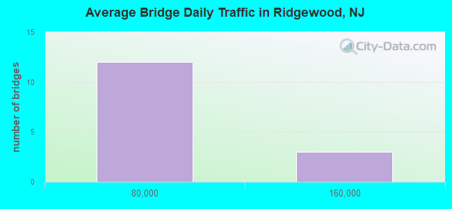
- 567,022Total average daily traffic
- 26,914Total average daily truck traffic
- National Bridge Inventory (NBI) Registered Bridges for Ridgewood
- No street view available for this location
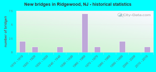
- New bridges - historical statistics
- 21910-1919
- 11920-1929
- 11940-1949
- 71960-1969
- 11970-1979
- 21990-1999
- 12010-2019
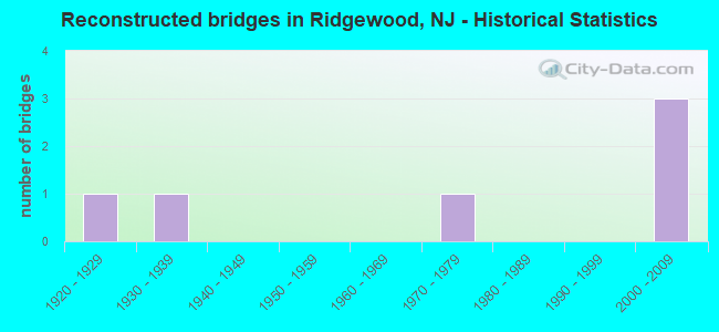
- Reconstructed bridges - Historical Statistics
- 11920-1929
- 11930-1939
- 01940-1949
- 01950-1959
- 01960-1969
- 11970-1979
- 01980-1989
- 01990-1999
- 32000-2009
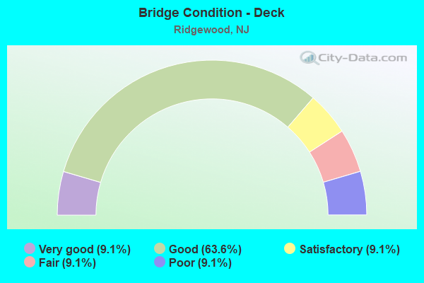
- Bridge Condition - Deck
- 9.1%Very good
- 63.6%Good
- 9.1%Satisfactory
- 9.1%Fair
- 9.1%Poor
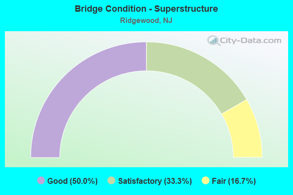
- Bridge Condition - Superstructure
- 50.0%Good
- 33.3%Satisfactory
- 16.7%Fair
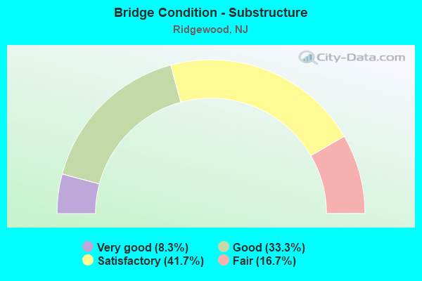
- Bridge Condition - Substructure
- 8.3%Very good
- 33.3%Good
- 41.7%Satisfactory
- 16.7%Fair
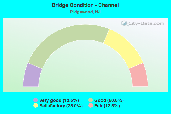
- Bridge Condition - Channel
- 12.5%Very good
- 50.0%Good
- 25.0%Satisfactory
- 12.5%Fair
Find on map >> Show street view
Structure Number: 20051A, Location: 1.63 mi West NJ 17 (Lat: 40.977169, Lng: -74.108000), Route carried "on" structure: County highway 80I, Year Built: 1910, Year Reconstructed: 1936, Status: Open, Structure Length: 1.89m (6.20ft), Average Daily Traffic: 12,690 (year 2020), Truck Traffic: 4%, Average Future Daily Traffic: 15,230 (year 2040), Features Intersected: HOHOKUS BROOK, Facility Carried by Structure: E. RIDGEWOOD AVE
Minimum Vertical Clearance: 30+ m (98+ ft), Kilometerpoint: 3.322, Lanes on structure: 2, Base Highway Network: Yes, Owner: County Highway Agency, Approaching Roadway Width: 9.2m (30.2ft), Skew: 3 degrees, Material/Design: Steel, Design/Construction: Arch - Deck, Number Of Spans In Main Unit: 1, Length of Maximum Span: 18.9m (62.0ft), Curb or Sidewalk Widths: Left: 2.6m (8.5ft), Right: 2.6m (8.5ft), Curb-To-Curb Width: 9.2m (30.2ft), Out-to-Out Width: 15.5m (50.9ft)
Condition: Superstructure: Fair, Substructure: Satisfactory, Channel: Good, Operating Rating: 36.3 metric tons, Method Used To Determine Operating Rating: Field evaluation and documented engineering judgment, Inventory Rating: 21.8 metric tons, Method Used To Determine Inventory Rating: Field evaluation and documented engineering judgment, Structural Evaluation: Somewhat better than minimum adequacy, Deck Geometry: High priority of corrective action, Waterway Adequacy: Equal to present desirable criteria, Approach Roadway Alignment: Equal to present minimum criteria, Length Of Structure Improvement: 1.89m (6.20ft), Designated Inspection Frequency: Every 24 months, Inspection Date: April 2020, Bridge Improvement Cost: $16,000, Roadway Improvement Cost: $212,000, Total Project Cost: $335,000 ( Estimate for 2020)
Find on map >> Show street view
Structure Number: 20051B, Location: .02 mi. E. of CR 507 (Lat: 40.986919, Lng: -74.112000), Route carried "on" structure: City street , Year Built: 1993, Status: Open, Structure Length: 2.07m (6.79ft), Average Daily Traffic: 1,067 (year 2020), Truck Traffic: 1%, Average Future Daily Traffic: 1,281 (year 2040), Design Load: HS 25 or greater, Features Intersected: HO-HO-KUS BROOK, Facility Carried by Structure: MEADOWBROOK AVENUE
Minimum Vertical Clearance: 30+ m (98+ ft), Kilometerpoint: 0.000, Lanes on structure: 2, Owner: County Highway Agency, Approaching Roadway Width: 9.1m (29.9ft), Skew: 1 degrees, Material/Design: Prestressed concrete, Design/Construction: Box Beam or Girders - Multiple, Number Of Spans In Main Unit: 1, Length of Maximum Span: 19.8m (65.0ft), Curb or Sidewalk Widths: Left: 2.6m (8.5ft), Right: 2.6m (8.5ft), Curb-To-Curb Width: 9.1m (29.9ft), Out-to-Out Width: 14.8m (48.6ft)
Condition: Deck: Good, Superstructure: Good, Substructure: Good, Channel: Good, Operating Rating: 64.4 metric tons, Method Used To Determine Operating Rating: Load Factor (LF), Inventory Rating: 31.8 metric tons, Method Used To Determine Inventory Rating: Load Factor (LF), Structural Evaluation: Better than present minimum criteria, Deck Geometry: Somewhat better than minimum adequacy, Waterway Adequacy: Superior to present desirable criteria, Approach Roadway Alignment: Equal to present minimum criteria, Designated Inspection Frequency: Every 24 months, Inspection Date: April 2020, Deck Structure Type: Concrete Cast-file-Place, Wearing Surface/Protective System: Wearing Surface: Monolithic Concrete, Deck Protection: Epoxy Coated Reinforcing
Find on map >> Show street view
Structure Number: 20051C, Location: 0.38 Mile East of CR 507 (Lat: 40.973400, Lng: -74.108650), Route carried "on" structure: City street , Year Built: 1946, Status: Open, Structure Length: 1.74m (5.71ft), Average Daily Traffic: 3,484 (year 2020), Truck Traffic: 3%, Average Future Daily Traffic: 4,181 (year 2040), Features Intersected: HO-HO-KUS BROOK, Facility Carried by Structure: SPRING STREET
Minimum Vertical Clearance: 30+ m (98+ ft), Kilometerpoint: 0.772, Lanes on structure: 2, Owner: County Highway Agency, Approaching Roadway Width: 7.6m (24.9ft), Skew: 1 degrees, Material/Design: Steel, Design/Construction: Stringer/Multi-beam, Number Of Spans In Main Unit: 1, Length of Maximum Span: 15.8m (51.8ft), Curb or Sidewalk Widths: Left: 2.0m (6.6ft), Right: 2.0m (6.6ft), Curb-To-Curb Width: 7.6m (24.9ft), Out-to-Out Width: 12.4m (40.7ft)
Condition: Deck: Very good, Superstructure: Satisfactory, Substructure: Fair, Channel: Satisfactory, Operating Rating: 26.3 metric tons, Method Used To Determine Operating Rating: Load Factor (LF), Inventory Rating: 15.4 metric tons, Method Used To Determine Inventory Rating: Load Factor (LF), Structural Evaluation: Meets minimum limits, Deck Geometry: High priority of replacement, Waterway Adequacy: Superior to present desirable criteria, Approach Roadway Alignment: Equal to present desirable criteria, Length Of Structure Improvement: 2.44m (8.01ft), Designated Inspection Frequency: Every 24 months, Inspection Date: April 2020, Bridge Improvement Cost: $1,558,000, Roadway Improvement Cost: $156,000, Total Project Cost: $2,240,000 ( Estimate for 2020), Deck Structure Type: Concrete Cast-file-Place, Wearing Surface/Protective System: Wearing Surface: Bituminous
Find on map >> Show street view
Structure Number: 20051D, Location: 1.58 mi East of CR 81 (Lat: 40.989461, Lng: -74.112161), Route carried "on" structure: County highway 82I, Year Built: 1993, Status: Open, Structure Length: 2.50m (8.20ft), Average Daily Traffic: 7,780 (year 2020), Truck Traffic: 4%, Average Future Daily Traffic: 9,333 (year 2040), Design Load: HS 25 or greater, Features Intersected: HOHOKUS BROOK
Minimum Vertical Clearance: 30+ m (98+ ft), Kilometerpoint: 2.546, Lanes on structure: 3, Owner: County Highway Agency, Approaching Roadway Width: 11.9m (39.0ft), Skew: 2 degrees, Material/Design: Steel, Design/Construction: Stringer/Multi-beam, Number Of Spans In Main Unit: 2, Length of Maximum Span: 11.3m (37.1ft), Curb or Sidewalk Widths: Left: 2.1m (6.9ft), Right: 1.8m (5.9ft), Curb-To-Curb Width: 11.9m (39.0ft), Out-to-Out Width: 17.0m (55.8ft)
Condition: Deck: Good, Superstructure: Good, Substructure: Satisfactory, Channel: Very good, Inventory Rating: 68.9 metric tons, Method Used To Determine Inventory Rating: Load Factor (LF), Structural Evaluation: Equal to present minimum criteria, Deck Geometry: High priority of corrective action, Waterway Adequacy: Superior to present desirable criteria, Approach Roadway Alignment: Better than present minimum criteria, Designated Inspection Frequency: Every 24 months, Inspection Date: April 2020, Deck Structure Type: Concrete Cast-file-Place, Wearing Surface/Protective System: Wearing Surface: Monolithic Concrete, Deck Protection: Epoxy Coated Reinforcing
Find on map >> Show street view
Structure Number: 20051E, Location: 0.094 mi east of CR 507 (Lat: 40.983500, Lng: -74.110331), Route carried "on" structure: County highway 110I, Year Built: 1978, Status: Open, Structure Length: 1.92m (6.30ft), Average Daily Traffic: 19,440 (year 2020), Truck Traffic: 4%, Average Future Daily Traffic: 23,330 (year 2040), Design Load: HS 20+Mod, Features Intersected: HO-HO-KUS BROOK
Minimum Vertical Clearance: 30+ m (98+ ft), Kilometerpoint: 0.151, Lanes on structure: 2, Owner: County Highway Agency, Approaching Roadway Width: 9.2m (30.2ft), Skew: 1 degrees, Material/Design: Prestressed concrete, Design/Construction: Box Beam or Girders - Multiple, Number Of Spans In Main Unit: 1, Length of Maximum Span: 18.3m (60.0ft), Curb or Sidewalk Widths: Left: 2.3m (7.5ft), Right: 2.1m (6.9ft), Curb-To-Curb Width: 9.2m (30.2ft), Out-to-Out Width: 15.4m (50.5ft)
Condition: Deck: Satisfactory, Superstructure: Satisfactory, Substructure: Satisfactory, Channel: Good, Operating Rating: 32.7 metric tons, Method Used To Determine Operating Rating: Load Factor (LF), Inventory Rating: 20.0 metric tons, Method Used To Determine Inventory Rating: Load Factor (LF), Structural Evaluation: Somewhat better than minimum adequacy, Deck Geometry: High priority of corrective action, Waterway Adequacy: Equal to present desirable criteria, Approach Roadway Alignment: Equal to present minimum criteria, Length Of Structure Improvement: 1.92m (6.30ft), Designated Inspection Frequency: Every 24 months, Inspection Date: April 2020, Bridge Improvement Cost: $20,000, Roadway Improvement Cost: $106,000, Total Project Cost: $188,000 ( Estimate for 2020), Deck Structure Type: Concrete Precast Panels, Wearing Surface/Protective System: Wearing Surface: Bituminous
Find on map >> Show street view
Structure Number: 20051G, Location: .15 Mi E of Franklin Ave. (Lat: 40.980269, Lng: -74.107411), Route carried "on" structure: City street , Year Built: 1960, Status: Open, Structure Length: 1.62m (5.31ft), Average Daily Traffic: 2,420 (year 2020), Truck Traffic: 3%, Average Future Daily Traffic: 2,905 (year 2040), Features Intersected: HO-HO-KUS BROOK, Facility Carried by Structure: NORTH IRVING ST.
Minimum Vertical Clearance: 30+ m (98+ ft), Kilometerpoint: 1.738, Lanes on structure: 2, Owner: County Highway Agency, Approaching Roadway Width: 9.8m (32.2ft), Material/Design: Steel, Design/Construction: Stringer/Multi-beam, Number Of Spans In Main Unit: 1, Length of Maximum Span: 14.9m (48.9ft), Curb or Sidewalk Widths: Left: 2.3m (7.5ft), Right: 2.3m (7.5ft), Curb-To-Curb Width: 9.8m (32.2ft), Out-to-Out Width: 15.2m (49.9ft)
Condition: Deck: Poor, Superstructure: Satisfactory, Substructure: Good, Channel: Fair, Operating Rating: 39.9 metric tons, Method Used To Determine Operating Rating: Load Factor (LF), Inventory Rating: 23.6 metric tons, Method Used To Determine Inventory Rating: Load Factor (LF), Structural Evaluation: Equal to present minimum criteria, Deck Geometry: Meets minimum limits, Waterway Adequacy: Equal to present minimum criteria, Approach Roadway Alignment: Somewhat better than minimum adequacy, Length Of Structure Improvement: 1.62m (5.31ft), Designated Inspection Frequency: Every 24 months, Inspection Date: April 2020, Bridge Improvement Cost: $99,000, Total Project Cost: $331,000 ( Estimate for 2020), Deck Structure Type: Concrete Cast-file-Place, Wearing Surface/Protective System: Wearing Surface: Bituminous
Find on map >> Show street view
Structure Number: 216157, Location: 3.4 MI N OF GSP EXIT 163 (Lat: 40.985081, Lng: -74.090869), Route carried "on" structure: State highway 17, Year Built: 1927, Year Reconstructed: 1984, Status: Open, Structure Length: 1.58m (5.18ft), Average Daily Traffic: 120,775 (year 2020), Truck Traffic: 5%, Average Future Daily Traffic: 147,346 (year 2040), Design Load: HS 20+Mod, Features Intersected: SADDLE RIVER
Minimum Vertical Clearance: 30.45m (99.90ft), Kilometerpoint: 27.439, Lanes on structure: 7, Base Highway Network: Yes, Owner: State Highway Agency, Approaching Roadway Width: 32.6m (107.0ft), Skew: 31 degrees, Material/Design: Prestressed concrete, Design/Construction: Box Beam or Girders - Multiple, Number Of Spans In Main Unit: 1, Length of Maximum Span: 14.3m (46.9ft), Curb or Sidewalk Widths: Left: 1.8m (5.9ft), Right: 1.8m (5.9ft), Curb-To-Curb Width: 32.5m (106.6ft), Out-to-Out Width: 37.5m (123.0ft)
Condition: Deck: Good, Superstructure: Good, Substructure: Good, Channel: Satisfactory, Operating Rating: 83.5 metric tons, Method Used To Determine Operating Rating: Load Factor (LF), Inventory Rating: 41.7 metric tons, Method Used To Determine Inventory Rating: Load Factor (LF), Structural Evaluation: Better than present minimum criteria, Deck Geometry: Better than present minimum criteria, Waterway Adequacy: Equal to present desirable criteria, Approach Roadway Alignment: Equal to present desirable criteria, Designated Inspection Frequency: Every 24 months, Inspection Date: March 2020, Deck Structure Type: Concrete Cast-file-Place, Wearing Surface/Protective System: Wearing Surface: Monolithic Concrete, Deck Protection: Epoxy Coated Reinforcing
Find on map >> Show street view
Structure Number: 216159, Location: 0.05 MI EAST OF NJ 17 (Lat: 40.980000, Lng: -74.083650), Route carried "on" structure: County highway 110I, Year Built: 1965, Year Reconstructed: 2009, Status: Open, Structure Length: 3.02m (9.91ft), Average Daily Traffic: 29,098 (year 2020), Truck Traffic: 4%, Average Future Daily Traffic: 35,500 (year 2040), Features Intersected: VAN EMBURGH AVE (CR 71), Facility Carried by Structure: LINWOOD AVE
Minimum Vertical Clearance: 30.45m (99.90ft), Kilometerpoint: 2.527, Lanes on structure: 3, Lanes under structure: 1, Owner: State Highway Agency, Approaching Roadway Width: 13.4m (44.0ft), Skew: 21 degrees, Material/Design: Steel, Design/Construction: Stringer/Multi-beam, Number Of Spans In Main Unit: 1, Length of Maximum Span: 28.0m (91.9ft), Curb or Sidewalk Widths: Left: 2.4m (7.9ft), Right: 1.8m (5.9ft), Curb-To-Curb Width: 13.5m (44.3ft), Out-to-Out Width: 19.5m (64.0ft)
Condition: Deck: Good, Superstructure: Good, Substructure: Good, Inventory Rating: 64.4 metric tons, Method Used To Determine Inventory Rating: Load Factor (LF), Structural Evaluation: Better than present minimum criteria, Deck Geometry: Somewhat better than minimum adequacy, Underclear: Equal to present minimum criteria, Approach Roadway Alignment: Better than present minimum criteria, Designated Inspection Frequency: Every 24 months, Inspection Date: March 2020, Deck Structure Type: Concrete Cast-file-Place, Wearing Surface/Protective System: Wearing Surface: Latex Concrete, Deck Protection: Epoxy Coated Reinforcing
Find on map >> Show street view
Structure Number: 21616, Location: 4.2 MI NORTH OF NJ 4 (Lat: 40.980231, Lng: -74.084631), Route carried "on" structure: County highway 110I, Year Built: 1964, Year Reconstructed: 2009, Status: Open, Structure Length: 6.49m (21.29ft), Average Daily Traffic: 19,437 (year 2020), Truck Traffic: 4%, Average Future Daily Traffic: 23,713 (year 2040), Features Intersected: NJ 17, Facility Carried by Structure: LINWOOD AVENUE
Minimum Vertical Clearance: 30.45m (99.90ft), Kilometerpoint: 2.446, Lanes on structure: 4, Lanes under structure: 8, Owner: State Highway Agency, Approaching Roadway Width: 15.8m (51.8ft), Skew: 29 degrees, Material/Design: Steel, Design/Construction: Stringer/Multi-beam, Number Of Spans In Main Unit: 2, Length of Maximum Span: 31.1m (102.0ft), Curb or Sidewalk Widths: Left: 2.4m (7.9ft), Right: 1.8m (5.9ft), Curb-To-Curb Width: 15.9m (52.2ft), Out-to-Out Width: 21.9m (71.9ft)
Condition: Deck: Good, Superstructure: Satisfactory, Substructure: Satisfactory, Operating Rating: 46.3 metric tons, Method Used To Determine Operating Rating: Load Factor (LF), Inventory Rating: 28.1 metric tons, Method Used To Determine Inventory Rating: Load Factor (LF), Structural Evaluation: Equal to present minimum criteria, Deck Geometry: Meets minimum limits, Underclear: High priority of corrective action, Approach Roadway Alignment: Equal to present minimum criteria, Length Of Structure Improvement: 6.49m (21.29ft), Designated Inspection Frequency: Every 24 months, Inspection Date: April 2020, Bridge Improvement Cost: $1,000, Total Project Cost: $2,000 ( Estimate for 2020), Deck Structure Type: Concrete Cast-file-Place, Wearing Surface/Protective System: Deck Protection: Epoxy Coated Reinforcing
Find on map >> Show street view
Structure Number: 216161, Location: 4.5 MI NORTH OF GSP (Lat: 40.982711, Lng: -74.088650), Route carried "on" structure: County highway 62I, Year Built: 1965, Year Reconstructed: 2008, Status: Open, Structure Length: 8.23m (27.00ft), Average Daily Traffic: 16,147 (year 2020), Truck Traffic: 4%, Average Future Daily Traffic: 19,699 (year 2040), Design Load: HL 93, Features Intersected: NJ 17
Minimum Vertical Clearance: 30.45m (99.90ft), Kilometerpoint: 12.424, Lanes on structure: 4, Lanes under structure: 8, Owner: State Highway Agency, Approaching Roadway Width: 15.8m (51.8ft), Skew: 24 degrees, Material/Design: Steel, Design/Construction: Stringer/Multi-beam, Number Of Spans In Main Unit: 4, Length of Maximum Span: 30.8m (101.0ft), Curb or Sidewalk Widths: Left: 1.8m (5.9ft), Right: 2.4m (7.9ft), Curb-To-Curb Width: 15.8m (51.8ft), Out-to-Out Width: 21.9m (71.9ft)
Condition: Deck: Good, Superstructure: Good, Substructure: Fair, Operating Rating: 46.0 metric tons, Method Used To Determine Operating Rating: Load and Resistance Factor Rating (LRFR) rating reported by rating factor(RF) method using HL-93 loadings, Inventory Rating: 35.6 metric tons, Method Used To Determine Inventory Rating: Load and Resistance Factor Rating (LRFR) rating reported by rating factor(RF) method using HL-93 loadings, Structural Evaluation: Somewhat better than minimum adequacy, Deck Geometry: Meets minimum limits, Underclear: High priority of corrective action, Approach Roadway Alignment: Better than present minimum criteria, Length Of Structure Improvement: 8.23m (27.00ft), Designated Inspection Frequency: Every 24 months, Inspection Date: April 2020, Bridge Improvement Cost: $3,000, Total Project Cost: $3,000 ( Estimate for 2020), Deck Structure Type: Concrete Cast-file-Place, Wearing Surface/Protective System: Wearing Surface: Monolithic Concrete, Deck Protection: Epoxy Coated Reinforcing
Find on map >> Show street view
Structure Number: 105016, Location: 0.5 MI W. OF Rte 579 (Lat: 40.647150, Lng: -75.090500), Route carried "on" structure: Other road , Year Built: 1917, Year Reconstructed: 1934, Status: Posted for load, Structure Length: 2.93m (9.61ft), Average Daily Traffic: 155 (year 2020), Truck Traffic: 3%, Average Future Daily Traffic: 190 (year 2040), Features Intersected: LEHIGH VALLEY ML (NS), Facility Carried by Structure: MILFORD RD.
Minimum Vertical Clearance: 30+ m (98+ ft), Kilometerpoint: 0.000, Lanes on structure: 2, Maintenance Responsibility: State Highway Agency, Approaching Roadway Width: 7.6m (24.9ft), Material/Design: Steel, Design/Construction: Truss - Thru, Number Of Spans In Main Unit: 1, Length of Maximum Span: 28.0m (91.9ft), Curb or Sidewalk Widths: Left: 0.2m (0.7ft), Right: 0.2m (0.7ft), Curb-To-Curb Width: 5.9m (19.4ft), Out-to-Out Width: 6.5m (21.3ft)
Condition: Deck: Fair, Superstructure: Fair, Substructure: Satisfactory, Operating Rating: 41.7 metric tons, Method Used To Determine Operating Rating: Load Factor (LF), Inventory Rating: 30.8 metric tons, Method Used To Determine Inventory Rating: Load Factor (LF), Structural Evaluation: Somewhat better than minimum adequacy, Deck Geometry: High priority of corrective action, Underclear: Somewhat better than minimum adequacy, Approach Roadway Alignment: Somewhat better than minimum adequacy, Length Of Structure Improvement: 3.81m (12.50ft), Designated Inspection Frequency: Every 24 months, Critical Feature Inspection Frequency: Every 24 months, Inspection Date: October 2020, Critical Feature Inspection Date: October 2020, Bridge Improvement Cost: $2,008,000, Roadway Improvement Cost: $201,000, Total Project Cost: $3,579,000 ( Estimate for 2020), Deck Structure Type: Wood or Timber, Wearing Surface/Protective System: Wearing Surface: Wood or Timber
Find on map >> Show street view
Structure Number: 1501155, Location: 4.6 MI S OF NJ 72 JCT (Lat: 39.638239, Lng: -74.304731), Route carried "on" structure: US 9, Year Built: 2013, Status: Open, Structure Length: 1.25m (4.10ft), Average Daily Traffic: 15,286 (year 2020), Truck Traffic: 4%, Average Future Daily Traffic: 18,652 (year 2040), Design Load: HL 93, Features Intersected: WESTECUNK CREEK
Minimum Vertical Clearance: 30+ m (98+ ft), Kilometerpoint: 106.136, Lanes on structure: 2, Owner: State Highway Agency, Approaching Roadway Width: 13.4m (44.0ft), Material/Design: Concrete, Design/Construction: Frame, Number Of Spans In Main Unit: 1, Length of Maximum Span: 11.6m (38.1ft), Curb or Sidewalk Widths: Left: 1.9m (6.2ft), Right: 1.9m (6.2ft), Curb-To-Curb Width: 13.4m (44.0ft), Out-to-Out Width: 18.1m (59.4ft)
Condition: Deck: Good, Superstructure: Good, Substructure: Very good, Channel: Good, Operating Rating: 45.0 metric tons, Method Used To Determine Operating Rating: Load and Resistance Factor Rating (LRFR) rating reported by rating factor(RF) method using HL-93 loadings, Inventory Rating: 34.7 metric tons, Method Used To Determine Inventory Rating: Load and Resistance Factor Rating (LRFR) rating reported by rating factor(RF) method using HL-93 loadings, Structural Evaluation: Better than present minimum criteria, Deck Geometry: Equal to present minimum criteria, Waterway Adequacy: Equal to present minimum criteria, Approach Roadway Alignment: Equal to present desirable criteria, Designated Inspection Frequency: Every 24 months, Inspection Date: September 2020, Deck Structure Type: Concrete Cast-file-Place, Wearing Surface/Protective System: Deck Protection: Epoxy Coated Reinforcing
Find on map >> Show street view
Structure Number: 216159, Location: 0.05 MI EAST OF NJ 17 (Lat: 40.980000, Lng: -74.083650), Route carried "under" structure: County highway 71, Year Built: 1965, Structure Length: 0. m, Average Daily Traffic: 6,676 (year 2020), Truck Traffic: 4%, Features Intersected: VAN EMBURGH AVE (CR 71), Facility Carried by Structure: LINWOOD AVE
Minimum Vertical Clearance: 4.70m (15.42ft), Kilometerpoint: 0.064, Lanes on structure: 3, Lanes under structure: 1, Material/Design: Steel, Design/Construction: Stringer/Multi-beam, Length of Maximum Span: 28.0m (91.9ft)
Find on map >> Show street view
Structure Number: 21616, Location: 4.2 MI NORTH OF NJ 4 (Lat: 40.980231, Lng: -74.084631), Route carried "under" structure: State highway 17, Year Built: 1964, Structure Length: 0. m, Average Daily Traffic: 157,061 (year 2020), Truck Traffic: 5%, Features Intersected: NJ 17, Facility Carried by Structure: LINWOOD AVENUE
Minimum Vertical Clearance: 4.98m (16.34ft), Kilometerpoint: 26.651, Lanes on structure: 4, Lanes under structure: 8, Material/Design: Steel, Design/Construction: Stringer/Multi-beam, Length of Maximum Span: 31.1m (102.0ft)
Find on map >> Show street view
Structure Number: 216161, Location: 4.5 MI NORTH OF GSP (Lat: 40.982711, Lng: -74.088650), Route carried "under" structure: State highway 17, Year Built: 1965, Structure Length: 0. m, Average Daily Traffic: 155,506 (year 2020), Truck Traffic: 5%, Features Intersected: NJ 17, Facility Carried by Structure: PARAMUS RD (CR62I)
Minimum Vertical Clearance: 4.72m (15.49ft), Kilometerpoint: 27.166, Lanes on structure: 4, Lanes under structure: 8, Material/Design: Steel, Design/Construction: Stringer/Multi-beam, Length of Maximum Span: 30.8m (101.0ft)