Bridge Statistics for Riviera Beach, Florida (FL)
Condition, Traffic, Stress, Structural Evaluation, Project Costs
- National Bridge Inventory (NBI) Statistics
- 18Number of bridges
- 715ft / 218mTotal length
- 633,200Total average daily traffic
- 54,245Total average daily truck traffic
- National Bridge Inventory (NBI) Registered Bridges for Riviera Beach
- No street view available for this location
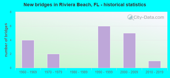
- New bridges - historical statistics
- 41960-1969
- 21970-1979
- 61990-1999
- 52000-2009
- 12010-2019


- Bridge Condition - Deck
- 9.1%Very good
- 81.8%Good
- 9.1%Satisfactory

- Bridge Condition - Superstructure
- 90.9%Good
- 9.1%Fair

- Bridge Condition - Substructure
- 9.1%Very good
- 81.8%Good
- 9.1%Satisfactory

- Bridge Condition - Channel
- 50.0%Good
- 50.0%Satisfactory
Find on map >> Show street view
Structure Number: 930172, Location: 0.75 mile South of SR 708 (Lat: 26.772033, Lng: -80.096419), Route carried "on" structure: Interstate 95, Year Built: 1967, Year Reconstructed: 2007, Status: Open, Structure Length: 17.31m (56.79ft), Average Daily Traffic: 94,000 (year 2020), Truck Traffic: 9%, Average Future Daily Traffic: 163,090 (year 2042), Design Load: HS 20+Mod, Features Intersected: SR 710 and CSX RR
Minimum Vertical Clearance: 30+ m (98+ ft), Kilometerpoint: 51.748, Lanes on structure: 6, Lanes under structure: 4, Base Highway Network: Yes, Owner: State Highway Agency, Approaching Roadway Width: 30.8m (101.0ft), Skew: 5 degrees, Material/Design: Prestressed concrete, Design/Construction: Stringer/Multi-beam, Number Of Spans In Main Unit: 6, Length of Maximum Span: 30.9m (101.4ft), Curb-To-Curb Width: 30.8m (101.0ft), Out-to-Out Width: 31.9m (104.7ft)
Condition: Deck: Good, Superstructure: Good, Substructure: Good, Operating Rating: 67.1 metric tons, Method Used To Determine Operating Rating: Load Factor (LF), Inventory Rating: 41.7 metric tons, Method Used To Determine Inventory Rating: Load Factor (LF), Structural Evaluation: Better than present minimum criteria, Deck Geometry: Superior to present desirable criteria, Underclear: Equal to present minimum criteria, Approach Roadway Alignment: Equal to present desirable criteria, Designated Inspection Frequency: Every 24 months, Inspection Date: March 2020, Deck Structure Type: Concrete Cast-file-Place
Find on map >> Show street view
Structure Number: 930173, Location: 0.75 mile South of SR 708 (Lat: 26.771750, Lng: -80.096000), Route carried "on" structure: Interstate 95, Year Built: 1967, Year Reconstructed: 2007, Status: Open, Structure Length: 17.31m (56.79ft), Average Daily Traffic: 94,000 (year 2020), Truck Traffic: 9%, Average Future Daily Traffic: 163,090 (year 2042), Design Load: HS 20+Mod, Features Intersected: SR 710 and CSX RR
Minimum Vertical Clearance: 30+ m (98+ ft), Kilometerpoint: 51.665, Lanes on structure: 6, Lanes under structure: 4, Base Highway Network: Yes, Owner: State Highway Agency, Approaching Roadway Width: 30.3m (99.4ft), Skew: 5 degrees, Material/Design: Prestressed concrete, Design/Construction: Stringer/Multi-beam, Number Of Spans In Main Unit: 6, Length of Maximum Span: 30.9m (101.4ft), Curb-To-Curb Width: 30.3m (99.4ft), Out-to-Out Width: 31.2m (102.4ft)
Condition: Deck: Good, Superstructure: Good, Substructure: Good, Operating Rating: 67.1 metric tons, Method Used To Determine Operating Rating: Load Factor (LF), Inventory Rating: 41.7 metric tons, Method Used To Determine Inventory Rating: Load Factor (LF), Structural Evaluation: Better than present minimum criteria, Deck Geometry: Superior to present desirable criteria, Underclear: Equal to present minimum criteria, Approach Roadway Alignment: Equal to present desirable criteria, Designated Inspection Frequency: Every 24 months, Inspection Date: March 2020, Deck Structure Type: Concrete Cast-file-Place
Find on map >> Show street view
Structure Number: 930269, Location: 0.5 Mile East of US-1 (Lat: 26.782964, Lng: -80.048197), Route carried "on" structure: State highway A1A, Year Built: 1976, Status: Open, Structure Length: 60.23m (197.60ft), Average Daily Traffic: 17,200 (year 2020), Truck Traffic: 8%, Average Future Daily Traffic: 29,842 (year 2042), Design Load: H 15, Features Intersected: Intracoastal Waterway
Minimum Vertical Clearance: 30+ m (98+ ft), Kilometerpoint: 0.666, Lanes on structure: 4, Owner: State Highway Agency, Approaching Roadway Width: 25.2m (82.7ft), Skew: 30 degrees, Navigation Control: Yes ( Vertical Clearance: 19.8m (65.0ft), Horizontal Clearance: 27.4m (89.9ft)), Material/Design: Prestressed concrete, Design/Construction: Stringer/Multi-beam, Number Of Spans In Main Unit: 19, Length of Maximum Span: 39.3m (128.9ft), Curb or Sidewalk Widths: Left: 1.7m (5.6ft), Right: 1.7m (5.6ft), Curb-To-Curb Width: 23.8m (78.1ft), Out-to-Out Width: 29.1m (95.5ft)
Condition: Deck: Satisfactory, Superstructure: Fair, Substructure: Satisfactory, Channel: Good, Operating Rating: 52.5 metric tons, Method Used To Determine Operating Rating: Load Factor (LF), Inventory Rating: 32.8 metric tons, Method Used To Determine Inventory Rating: Load Factor (LF), Structural Evaluation: Somewhat better than minimum adequacy, Deck Geometry: Superior to present desirable criteria, Waterway Adequacy: Superior to present desirable criteria, Approach Roadway Alignment: Better than present minimum criteria, Designated Inspection Frequency: Every 24 months, Underwater Inspection Frequency: Every 24 months, Inspection Date: November 2021, Underwater Inspection Date: November 2021, Deck Structure Type: Concrete Precast Panels
Find on map >> Show street view
Structure Number: 930467, Location: 1 Mile East of I-95 (Lat: 26.783000, Lng: -80.091417), Route carried "on" structure: State highway 708, Year Built: 1997, Status: Open, Structure Length: 5.00m (16.40ft), Average Daily Traffic: 18,250 (year 2020), Truck Traffic: 7%, Average Future Daily Traffic: 31,664 (year 2042), Design Load: HS 25 or greater, Features Intersected: C-17 Canal, Facility Carried by Structure: WB Blue Heron Blvd
Minimum Vertical Clearance: 30+ m (98+ ft), Kilometerpoint: 2.118, Lanes on structure: 4, Base Highway Network: Yes, Owner: State Highway Agency, Approaching Roadway Width: 12.8m (42.0ft), Material/Design: Prestressed concrete, Design/Construction: Slab, Number Of Spans In Main Unit: 5, Length of Maximum Span: 11.0m (36.1ft), Curb or Sidewalk Widths: Left: 2.0m (6.6ft), Right: 0.6m (2.0ft), Curb-To-Curb Width: 15.1m (49.5ft), Out-to-Out Width: 18.2m (59.7ft)
Condition: Deck: Good, Superstructure: Good, Substructure: Good, Channel: Satisfactory, Operating Rating: 77.1 metric tons, Method Used To Determine Operating Rating: Load Factor (LF), Inventory Rating: 46.3 metric tons, Method Used To Determine Inventory Rating: Load Factor (LF), Structural Evaluation: Better than present minimum criteria, Deck Geometry: High priority of corrective action, Waterway Adequacy: Equal to present minimum criteria, Approach Roadway Alignment: Equal to present desirable criteria, Designated Inspection Frequency: Every 24 months, Underwater Inspection Frequency: Every 24 months, Inspection Date: July 2020, Underwater Inspection Date: July 2020, Deck Structure Type: Concrete Precast Panels, Wearing Surface/Protective System: Wearing Surface: Bituminous
Find on map >> Show street view
Structure Number: 930468, Location: 1 Mile East of I-95 (Lat: 26.782889, Lng: -80.091417), Route carried "on" structure: State highway 708, Year Built: 1997, Status: Open, Structure Length: 5.00m (16.40ft), Average Daily Traffic: 18,250 (year 2020), Truck Traffic: 7%, Average Future Daily Traffic: 31,664 (year 2042), Design Load: HS 25 or greater, Features Intersected: C-17 Canal, Facility Carried by Structure: EB Blue Heron Blvd
Minimum Vertical Clearance: 30+ m (98+ ft), Kilometerpoint: 2.118, Lanes on structure: 3, Base Highway Network: Yes, Owner: State Highway Agency, Approaching Roadway Width: 12.8m (42.0ft), Material/Design: Prestressed concrete, Design/Construction: Slab, Number Of Spans In Main Unit: 5, Length of Maximum Span: 11.0m (36.1ft), Curb or Sidewalk Widths: Left: 0.6m (2.0ft), Right: 2.0m (6.6ft), Curb-To-Curb Width: 11.8m (38.7ft), Out-to-Out Width: 14.9m (48.9ft)
Condition: Deck: Good, Superstructure: Good, Substructure: Good, Channel: Satisfactory, Operating Rating: 79.3 metric tons, Method Used To Determine Operating Rating: Load Factor (LF), Inventory Rating: 47.5 metric tons, Method Used To Determine Inventory Rating: Load Factor (LF), Structural Evaluation: Better than present minimum criteria, Deck Geometry: High priority of corrective action, Waterway Adequacy: Equal to present minimum criteria, Approach Roadway Alignment: Equal to present desirable criteria, Designated Inspection Frequency: Every 24 months, Underwater Inspection Frequency: Every 24 months, Inspection Date: July 2020, Underwater Inspection Date: July 2020, Deck Structure Type: Concrete Precast Panels, Wearing Surface/Protective System: Wearing Surface: Bituminous
Find on map >> Show street view
Structure Number: 93047, Location: Port of Palm Beach (Lat: 26.767092, Lng: -80.055422), Route carried "on" structure: US 1, Year Built: 2000, Status: Open, Structure Length: 57.91m (189.99ft), Average Daily Traffic: 23,000 (year 2020), Truck Traffic: 4%, Average Future Daily Traffic: 39,905 (year 2042), Design Load: HS 20+Mod, Features Intersected: SR-710 & Port of PB
Minimum Vertical Clearance: 30+ m (98+ ft), Kilometerpoint: 0.230, Lanes on structure: 4, Lanes under structure: 4, Owner: State Highway Agency, Approaching Roadway Width: 25.5m (83.7ft), Skew: 30 degrees, Material/Design: Prestressed concrete continuous, Design/Construction: Stringer/Multi-beam, Number Of Spans In Main Unit: 13, Length of Maximum Span: 45.7m (149.9ft), Curb or Sidewalk Widths: Left: 1.5m (4.9ft), Right: 1.5m (4.9ft), Curb-To-Curb Width: 25.5m (83.7ft), Out-to-Out Width: 31.1m (102.0ft)
Condition: Deck: Good, Superstructure: Good, Substructure: Good, Operating Rating: 56.9 metric tons, Method Used To Determine Operating Rating: Load Factor (LF), Inventory Rating: 34.2 metric tons, Method Used To Determine Inventory Rating: Load Factor (LF), Structural Evaluation: Better than present minimum criteria, Deck Geometry: Superior to present desirable criteria, Underclear: Equal to present minimum criteria, Approach Roadway Alignment: Better than present minimum criteria, Designated Inspection Frequency: Every 24 months, Inspection Date: January 2022, Deck Structure Type: Concrete Cast-file-Place
Find on map >> Show street view
Structure Number: 930519, Location: At Exit 76 (Lat: 26.783222, Lng: -80.099111), Route carried "on" structure: Interstate 95, Year Built: 2007, Status: Open, Structure Length: 6.10m (20.01ft), Average Daily Traffic: 188,000 (year 2022), Truck Traffic: 9%, Average Future Daily Traffic: 326,180 (year 2042), Design Load: HS 20, Features Intersected: SR 708 (Blue Heron Blvd)
Minimum Vertical Clearance: 30+ m (98+ ft), Kilometerpoint: 53.067, Lanes on structure: 10, Lanes under structure: 10, Base Highway Network: Yes, Owner: State Highway Agency, Approaching Roadway Width: 54.3m (178.1ft), Skew: 30 degrees, Material/Design: Prestressed concrete, Design/Construction: Stringer/Multi-beam, Number Of Spans In Main Unit: 2, Length of Maximum Span: 30.5m (100.1ft), Curb-To-Curb Width: 54.3m (178.1ft), Out-to-Out Width: 55.8m (183.1ft)
Condition: Deck: Very good, Superstructure: Good, Substructure: Good, Operating Rating: 80.1 metric tons, Method Used To Determine Operating Rating: Load Factor (LF), Inventory Rating: 48.1 metric tons, Method Used To Determine Inventory Rating: Load Factor (LF), Structural Evaluation: Better than present minimum criteria, Deck Geometry: Superior to present desirable criteria, Underclear: Better than present minimum criteria, Approach Roadway Alignment: Equal to present desirable criteria, Designated Inspection Frequency: Every 24 months, Inspection Date: Febuary 2022, Deck Structure Type: Concrete Cast-file-Place
Find on map >> Show street view
Structure Number: 930523, Location: 0.6mi East of Congress Av (Lat: 26.781094, Lng: -80.078603), Route carried "on" structure: State highway 708, Year Built: 1975, Status: Open, Structure Length: 0.63m (2.07ft), Average Daily Traffic: 36,500 (year 2020), Truck Traffic: 7%, Average Future Daily Traffic: 63,328 (year 2042), Design Load: HS 20+Mod, Features Intersected: Drainage Canal, Facility Carried by Structure: Blue Heron Blvd.
Minimum Vertical Clearance: 30+ m (98+ ft), Kilometerpoint: 3.452, Lanes on structure: 6, Base Highway Network: Yes, Owner: State Highway Agency, Approaching Roadway Width: 23.0m (75.5ft), Skew: 10 degrees, Material/Design: Concrete, Design/Construction: Culvert, Number Of Spans In Main Unit: 2, Length of Maximum Span: 3.0m (9.8ft), Curb or Sidewalk Widths: Left: 1.9m (6.2ft), Right: 1.4m (4.6ft)
Condition: Channel: Good, Culverts: Satisfactory, Operating Rating: 67.3 metric tons, Method Used To Determine Operating Rating: Load Factor (LF), Inventory Rating: 40.4 metric tons, Method Used To Determine Inventory Rating: Load Factor (LF), Structural Evaluation: Equal to present minimum criteria, Waterway Adequacy: Equal to present desirable criteria, Approach Roadway Alignment: Equal to present desirable criteria, Designated Inspection Frequency: Every 24 months, Underwater Inspection Frequency: Every 24 months, Inspection Date: December 2020, Underwater Inspection Date: December 2020
Find on map >> Show street view
Structure Number: 930534, Location: 0.25mi. east of I-95 (Lat: 26.770250, Lng: -80.091722), Route carried "on" structure: State highway 710, Year Built: 2008, Status: Open, Structure Length: 3.51m (11.52ft), Average Daily Traffic: 14,600 (year 2021), Truck Traffic: 13%, Average Future Daily Traffic: 25,331 (year 2042), Design Load: HL 93, Features Intersected: C-17 Canal
Minimum Vertical Clearance: 30+ m (98+ ft), Kilometerpoint: 34.952, Lanes on structure: 6, Base Highway Network: Yes, Owner: State Highway Agency, Approaching Roadway Width: 19.5m (64.0ft), Skew: 20 degrees, Material/Design: Prestressed concrete, Design/Construction: Stringer/Multi-beam, Number Of Spans In Main Unit: 3, Length of Maximum Span: 16.8m (55.1ft), Curb or Sidewalk Widths: Left: 2.0m (6.6ft), Right: 2.0m (6.6ft), Curb-To-Curb Width: 28.6m (93.8ft), Out-to-Out Width: 33.3m (109.3ft)
Condition: Deck: Good, Superstructure: Good, Substructure: Good, Channel: Good, Operating Rating: 48.6 metric tons, Method Used To Determine Operating Rating: Load and Resistance Factor (LRFR), Inventory Rating: 42.8 metric tons, Method Used To Determine Inventory Rating: Load and Resistance Factor (LRFR), Structural Evaluation: Better than present minimum criteria, Deck Geometry: Superior to present desirable criteria, Waterway Adequacy: Superior to present desirable criteria, Approach Roadway Alignment: Equal to present desirable criteria, Designated Inspection Frequency: Every 24 months, Underwater Inspection Frequency: Every 24 months, Inspection Date: July 2021, Underwater Inspection Date: July 2021, Deck Structure Type: Concrete Cast-file-Place
Find on map >> Show street view
Structure Number: 930545, Location: SR-A1A East of ICWW (Lat: 26.783683, Lng: -80.039867), Route carried "on" structure: State highway A1A, Year Built: 2011, Status: Open, Structure Length: 9.02m (29.59ft), Average Daily Traffic: 17,200 (year 2020), Truck Traffic: 8%, Average Future Daily Traffic: 29,842 (year 2042), Design Load: Greater than HL93, Features Intersected: Lake Worth Relief, Facility Carried by Structure: Blue Heron Blvd
Minimum Vertical Clearance: 30+ m (98+ ft), Kilometerpoint: 1.400, Lanes on structure: 4, Owner: State Highway Agency, Approaching Roadway Width: 22.7m (74.5ft), Skew: 20 degrees, Material/Design: Concrete continuous, Design/Construction: Slab, Number Of Spans In Main Unit: 8, Length of Maximum Span: 11.3m (37.1ft), Curb or Sidewalk Widths: Left: 2.4m (7.9ft), Right: 2.4m (7.9ft), Curb-To-Curb Width: 22.7m (74.5ft), Out-to-Out Width: 29.0m (95.1ft)
Condition: Deck: Good, Superstructure: Good, Substructure: Very good, Channel: Satisfactory, Operating Rating: 54.2 metric tons, Method Used To Determine Operating Rating: Load and Resistance Factor (LRFR), Inventory Rating: 41.8 metric tons, Method Used To Determine Inventory Rating: Load and Resistance Factor (LRFR), Structural Evaluation: Better than present minimum criteria, Deck Geometry: Superior to present desirable criteria, Waterway Adequacy: Superior to present desirable criteria, Approach Roadway Alignment: Equal to present desirable criteria, Designated Inspection Frequency: Every 24 months, Underwater Inspection Frequency: Every 24 months, Inspection Date: August 2021, Underwater Inspection Date: August 2021, Deck Structure Type: Concrete Cast-file-Place
Find on map >> Show street view
Structure Number: 934155, Location: 0.5MI N OF 45TH STREET (Lat: 26.766183, Lng: -80.088253), Route carried "on" structure: County highway , Year Built: 1994, Status: Open, Structure Length: 18.16m (59.58ft), Average Daily Traffic: 18,000 (year 2021), Truck Traffic: 5%, Average Future Daily Traffic: 21,600 (year 2042), Design Load: HS 20, Features Intersected: CHENEY WAY/CSX RR, Facility Carried by Structure: CONGRESS AVE (SB)
Minimum Vertical Clearance: 30+ m (98+ ft), Kilometerpoint: 8.758, Lanes on structure: 2, Lanes under structure: 2, Owner: County Highway Agency, Approaching Roadway Width: 13.1m (43.0ft), Skew: 9 degrees, Material/Design: Prestressed concrete, Design/Construction: Stringer/Multi-beam, Number Of Spans In Main Unit: 5, Length of Maximum Span: 38.1m (125.0ft), Curb or Sidewalk Widths: Left: 2.0m (6.6ft), Right: 0.0m, Curb-To-Curb Width: 13.4m (44.0ft), Out-to-Out Width: 16.2m (53.1ft)
Condition: Deck: Good, Superstructure: Good, Substructure: Good, Inventory Rating: 68.1 metric tons, Method Used To Determine Inventory Rating: Load Factor (LF), Structural Evaluation: Better than present minimum criteria, Deck Geometry: Superior to present desirable criteria, Underclear: Better than present minimum criteria, Approach Roadway Alignment: Equal to present desirable criteria, Designated Inspection Frequency: Every 24 months, Inspection Date: May 2021, Deck Structure Type: Concrete Cast-file-Place
Find on map >> Show street view
Structure Number: 934156, Location: 0.5MI N OF 45TH STREET (Lat: 26.766178, Lng: -80.088072), Route carried "on" structure: County highway , Year Built: 1994, Status: Open, Structure Length: 18.16m (59.58ft), Average Daily Traffic: 18,000 (year 2021), Truck Traffic: 5%, Average Future Daily Traffic: 21,600 (year 2042), Design Load: HS 20, Features Intersected: CHENEY WAY/CSX RR, Facility Carried by Structure: CONGRESS AVE (NB)
Minimum Vertical Clearance: 30+ m (98+ ft), Kilometerpoint: 8.758, Lanes on structure: 3, Lanes under structure: 2, Owner: County Highway Agency, Approaching Roadway Width: 13.1m (43.0ft), Skew: 9 degrees, Material/Design: Prestressed concrete, Design/Construction: Stringer/Multi-beam, Number Of Spans In Main Unit: 5, Length of Maximum Span: 38.1m (125.0ft), Curb or Sidewalk Widths: Left: 0.0m, Right: 2.0m (6.6ft), Curb-To-Curb Width: 13.1m (43.0ft), Out-to-Out Width: 16.2m (53.1ft)
Condition: Deck: Good, Superstructure: Good, Substructure: Good, Inventory Rating: 68.1 metric tons, Method Used To Determine Inventory Rating: Load Factor (LF), Structural Evaluation: Better than present minimum criteria, Deck Geometry: Meets minimum limits, Underclear: Better than present minimum criteria, Approach Roadway Alignment: Equal to present desirable criteria, Designated Inspection Frequency: Every 24 months, Inspection Date: May 2021, Deck Structure Type: Concrete Cast-file-Place
Find on map >> Show street view
Structure Number: 930172, Location: 0.75 mile South of SR 708 (Lat: 26.772033, Lng: -80.096419), Route carried "under" structure: State highway 710, Year Built: 1967, Structure Length: 0. m, Average Daily Traffic: 14,600 (year 2020), Truck Traffic: 13%, Features Intersected: SR 710 and CSX RR, Facility Carried by Structure: SB I 95 SR 9
Minimum Vertical Clearance: 6.83m (22.41ft), Kilometerpoint: 34.490, Lanes on structure: 6, Lanes under structure: 4, Material/Design: Prestressed concrete, Design/Construction: Stringer/Multi-beam, Length of Maximum Span: 30.9m (101.4ft)
Find on map >> Show street view
Structure Number: 930173, Location: 0.75 mile South of SR 708 (Lat: 26.771750, Lng: -80.096000), Route carried "under" structure: State highway 710, Year Built: 1967, Structure Length: 0. m, Average Daily Traffic: 14,600 (year 2020), Truck Traffic: 13%, Features Intersected: SR 710 and CSX RR, Facility Carried by Structure: NB I 95 SR 9
Minimum Vertical Clearance: 6.83m (22.41ft), Kilometerpoint: 34.545, Lanes on structure: 6, Lanes under structure: 4, Material/Design: Prestressed concrete, Design/Construction: Stringer/Multi-beam, Length of Maximum Span: 30.9m (101.4ft)
Find on map >> Show street view
Structure Number: 93047, Location: Port of Palm Beach (Lat: 26.767092, Lng: -80.055422), Route carried "under" structure: Business State highway 710, Year Built: 2000, Structure Length: 0. m, Average Daily Traffic: 10,000 (year 2018), Truck Traffic: 5%, Features Intersected: SR-710 & Port of PB, Facility Carried by Structure: US-1 (SR-5)
Minimum Vertical Clearance: 5.64m (18.50ft), Kilometerpoint: 38.703, Lanes on structure: 4, Lanes under structure: 4, Material/Design: Prestressed concrete continuous, Design/Construction: Stringer/Multi-beam, Length of Maximum Span: 45.7m (149.9ft)
Find on map >> Show street view
Structure Number: 930519, Location: At Exit 76 (Lat: 26.783222, Lng: -80.099111), Route carried "under" structure: State highway 708, Year Built: 2007, Structure Length: 0. m, Average Daily Traffic: 36,000 (year 2022), Truck Traffic: 8%, Features Intersected: SR 708 (Blue Heron Blvd), Facility Carried by Structure: I 95 SR 9
Minimum Vertical Clearance: 5.03m (16.50ft), Kilometerpoint: 1.357, Lanes on structure: 10, Lanes under structure: 10, Material/Design: Prestressed concrete, Design/Construction: Stringer/Multi-beam, Length of Maximum Span: 30.5m (100.1ft)
Find on map >> Show street view
Structure Number: 934155, Location: 0.5MI N OF 45TH STREET (Lat: 26.766183, Lng: -80.088253), Route carried "under" structure: Business City street , Year Built: 1994, Structure Length: 0. m, Average Daily Traffic: 500 (year 2021), Truck Traffic: 75%, Features Intersected: CHENEY WAY/CSX RR, Facility Carried by Structure: CONGRESS AVE (SB)
Minimum Vertical Clearance: 6.92m (22.70ft), Kilometerpoint: 0.000, Lanes on structure: 2, Lanes under structure: 2, Material/Design: Prestressed concrete, Design/Construction: Stringer/Multi-beam, Length of Maximum Span: 38.1m (125.0ft)
Find on map >> Show street view
Structure Number: 934156, Location: 0.5MI N OF 45TH STREET (Lat: 26.766178, Lng: -80.088072), Route carried "under" structure: Business City street , Year Built: 1994, Structure Length: 0. m, Average Daily Traffic: 500 (year 2021), Truck Traffic: 75%, Features Intersected: CHENEY WAY/CSX RR, Facility Carried by Structure: CONGRESS AVE (NB)
Minimum Vertical Clearance: 6.92m (22.70ft), Kilometerpoint: 0.000, Lanes on structure: 3, Lanes under structure: 2, Material/Design: Prestressed concrete, Design/Construction: Stringer/Multi-beam, Length of Maximum Span: 38.1m (125.0ft)