Bridge Statistics for Rohnert Park, California (CA)
Condition, Traffic, Stress, Structural Evaluation, Project Costs
- National Bridge Inventory (NBI) Statistics
- 39Number of bridges
- 348ft / 106mTotal length
- $796,000Total costs
- 870,831Total average daily traffic
- 50,389Total average daily truck traffic
- National Bridge Inventory (NBI) Registered Bridges for Rohnert Park
- No street view available for this location
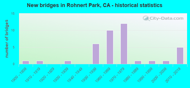
- New bridges - historical statistics
- 11900-1909
- 11910-1919
- 11930-1939
- 61950-1959
- 101960-1969
- 121970-1979
- 11980-1989
- 11990-1999
- 12000-2009
- 52010-2019

- Reconstructed bridges - Historical Statistics
- 11940-1949
- 01950-1959
- 01960-1969
- 01970-1979
- 11980-1989
- 11990-1999
- 32000-2009


- Bridge Condition - Deck
- 42.1%Good
- 52.6%Fair
- 5.3%Poor

- Bridge Condition - Superstructure
- 57.9%Good
- 5.3%Satisfactory
- 31.6%Fair
- 5.3%Poor

- Bridge Condition - Substructure
- 84.2%Good
- 15.8%Fair

- Bridge Condition - Channel
- 23.3%Very good
- 70.0%Good
- 6.7%Satisfactory

- Bridge Condition - Culverts
- 12.5%Good
- 87.5%Satisfactory
Find on map >> Show street view
Structure Number: 20 0012, Location: 04-SON-116-4.93 (Lat: 38.467194, Lng: -123.050031), Route carried "on" structure: State highway 116, Year Built: 1962, Status: Open, Structure Length: 11.58m (37.99ft), Average Daily Traffic: 5,175 (year 2016), Average Future Daily Traffic: 5,100 (year 2038), Design Load: HS 20, Features Intersected: AUSTIN CREEK
Minimum Vertical Clearance: 30+ m (98+ ft), Kilometerpoint: 4.930, Lanes on structure: 2, Base Highway Network: Yes (Inventory Route: 1, Subroute: 1), Owner: State Highway Agency, Approaching Roadway Width: 8.5m (27.9ft), Material/Design: Concrete continuous, Design/Construction: Box Beam or Girders - Multiple, Number Of Spans In Main Unit: 4, Length of Maximum Span: 36.0m (118.1ft), Curb or Sidewalk Widths: Left: 0.6m (2.0ft), Right: 0.6m (2.0ft), Curb-To-Curb Width: 8.6m (28.2ft), Out-to-Out Width: 10.4m (34.1ft)
Condition: Deck: Good, Superstructure: Good, Substructure: Good, Channel: Good, Operating Rating: 46.3 metric tons, Method Used To Determine Operating Rating: Load and Resistance Factor Rating (LRFR) rating reported by rating factor(RF) method using HL-93 loadings, Inventory Rating: 35.6 metric tons, Method Used To Determine Inventory Rating: Load and Resistance Factor Rating (LRFR) rating reported by rating factor(RF) method using HL-93 loadings, Structural Evaluation: Better than present minimum criteria, Deck Geometry: Meets minimum limits, Waterway Adequacy: Equal to present desirable criteria, Approach Roadway Alignment: Equal to present desirable criteria, Designated Inspection Frequency: Every 24 months, Inspection Date: June 2020, Deck Structure Type: Concrete Cast-file-Place
Find on map >> Show street view
Structure Number: 20 0015, Location: 04-SON-101-13.51-RNPK (Lat: 38.343081, Lng: -122.712719), Route carried "on" structure: US 101, Year Built: 1956, Year Reconstructed: 2011, Status: Open, Structure Length: 0.98m (3.22ft), Average Daily Traffic: 92,000 (year 2014), Truck Traffic: 6%, Average Future Daily Traffic: 166,227 (year 2038), Design Load: HS 20, Features Intersected: COPELAND CREEK
Minimum Vertical Clearance: 30+ m (98+ ft), Kilometerpoint: 13.510, Lanes on structure: 8, Base Highway Network: Yes (Inventory Route: 1, Subroute: 1), Owner: State Highway Agency, Approaching Roadway Width: 41.4m (135.8ft), Material/Design: Concrete continuous, Design/Construction: Slab, Number Of Spans In Main Unit: 2, Length of Maximum Span: 4.7m (15.4ft), Curb-To-Curb Width: 41.4m (135.8ft), Out-to-Out Width: 42.9m (140.7ft)
Condition: Deck: Fair, Superstructure: Fair, Substructure: Good, Channel: Good, Operating Rating: 46.7 metric tons, Method Used To Determine Operating Rating: Load Factor (LF), Inventory Rating: 27.9 metric tons, Method Used To Determine Inventory Rating: Load Factor (LF), Structural Evaluation: Somewhat better than minimum adequacy, Deck Geometry: Superior to present desirable criteria, Waterway Adequacy: Equal to present minimum criteria, Approach Roadway Alignment: Equal to present desirable criteria, Designated Inspection Frequency: Every 24 months, Inspection Date: April 2020, Deck Structure Type: Concrete Cast-file-Place, Wearing Surface/Protective System: Wearing Surface: Bituminous
Find on map >> Show street view
Structure Number: 20 0016, Location: 04-SON-101-13.09-RNPK (Lat: 38.336911, Lng: -122.712647), Route carried "on" structure: US 101, Year Built: 1956, Year Reconstructed: 2011, Status: Open, Structure Length: 0.67m (2.20ft), Average Daily Traffic: 92,000 (year 2014), Truck Traffic: 6%, Average Future Daily Traffic: 166,227 (year 2038), Design Load: HS 20, Features Intersected: LAGUNA DE SANTA ROSA
Minimum Vertical Clearance: 30+ m (98+ ft), Kilometerpoint: 13.090, Lanes on structure: 8, Base Highway Network: Yes (Inventory Route: 1, Subroute: 1), Owner: State Highway Agency, Approaching Roadway Width: 40.8m (133.9ft), Material/Design: Concrete continuous, Design/Construction: Culvert, Number Of Spans In Main Unit: 2, Length of Maximum Span: 3.0m (9.8ft), Curb-To-Curb Width: 40.8m (133.9ft), Out-to-Out Width: 42.4m (139.1ft)
Condition: Channel: Very good, Culverts: Good, Operating Rating: 54.1 metric tons, Method Used To Determine Operating Rating: Field evaluation and documented engineering judgment, Inventory Rating: 32.4 metric tons, Method Used To Determine Inventory Rating: Field evaluation and documented engineering judgment, Structural Evaluation: Better than present minimum criteria, Deck Geometry: Superior to present desirable criteria, Waterway Adequacy: Equal to present desirable criteria, Approach Roadway Alignment: Equal to present desirable criteria, Designated Inspection Frequency: Every 24 months, Inspection Date: April 2020, Deck Structure Type: Concrete Cast-file-Place, Wearing Surface/Protective System: Wearing Surface: Bituminous
Find on map >> Show street view
Structure Number: 20 0174, Location: 04-SON-101-15.52 (Lat: 38.371900, Lng: -122.714092), Route carried "on" structure: US 101, Year Built: 1957, Status: Open, Structure Length: 1.01m (3.31ft), Average Daily Traffic: 92,000 (year 2016), Truck Traffic: 6%, Average Future Daily Traffic: 166,227 (year 2038), Design Load: HS 20, Features Intersected: N BR LAGUNA DE SANTA RSA
Minimum Vertical Clearance: 30+ m (98+ ft), Kilometerpoint: 15.520, Lanes on structure: 6, Base Highway Network: Yes (Inventory Route: 1, Subroute: 1), Owner: State Highway Agency, Approaching Roadway Width: 41.4m (135.8ft), Skew: 1 degrees, Material/Design: Concrete continuous, Design/Construction: Culvert, Number Of Spans In Main Unit: 3, Length of Maximum Span: 3.0m (9.8ft), Curb or Sidewalk Widths: Left: 0.0m, Right: 0.7m (2.3ft), Curb-To-Curb Width: 41.4m (135.8ft), Out-to-Out Width: 42.4m (139.1ft)
Condition: Channel: Very good, Culverts: Satisfactory, Operating Rating: 54.1 metric tons, Method Used To Determine Operating Rating: Field evaluation and documented engineering judgment, Inventory Rating: 32.4 metric tons, Method Used To Determine Inventory Rating: Field evaluation and documented engineering judgment, Structural Evaluation: Equal to present minimum criteria, Deck Geometry: Superior to present desirable criteria, Waterway Adequacy: Equal to present desirable criteria, Approach Roadway Alignment: Equal to present desirable criteria, Designated Inspection Frequency: Every 24 months, Inspection Date: April 2020, Deck Structure Type: Concrete Cast-file-Place, Wearing Surface/Protective System: Wearing Surface: Bituminous
Find on map >> Show street view
Structure Number: 20 0233L, Location: 04-SON-101-R38.56 (Lat: 38.659389, Lng: -122.874478), Route carried "on" structure: US 101, Year Built: 1974, Status: Open, Structure Length: 4.97m (16.31ft), Average Daily Traffic: 13,500 (year 2015), Truck Traffic: 11%, Average Future Daily Traffic: 24,731 (year 2038), Design Load: HS 20, Features Intersected: LYTTON SPRINGS ROAD
Minimum Vertical Clearance: 30+ m (98+ ft), Kilometerpoint: 38.560, Lanes on structure: 2, Lanes under structure: 2, Base Highway Network: Yes (Inventory Route: 1, Subroute: 1), Owner: State Highway Agency, Approaching Roadway Width: 11.9m (39.0ft), Skew: 3 degrees, Material/Design: Prestressed concrete, Design/Construction: Box Beam or Girders - Multiple, Number Of Spans In Main Unit: 1, Length of Maximum Span: 49.1m (161.1ft), Curb-To-Curb Width: 11.9m (39.0ft), Out-to-Out Width: 12.5m (41.0ft)
Condition: Deck: Fair, Superstructure: Satisfactory, Substructure: Good, Operating Rating: 51.5 metric tons, Method Used To Determine Operating Rating: Load and Resistance Factor Rating (LRFR) rating reported by rating factor(RF) method using HL-93 loadings, Inventory Rating: 32.1 metric tons, Method Used To Determine Inventory Rating: Load and Resistance Factor Rating (LRFR) rating reported by rating factor(RF) method using HL-93 loadings, Structural Evaluation: Equal to present minimum criteria, Deck Geometry: Better than present minimum criteria, Underclear: Equal to present minimum criteria, Approach Roadway Alignment: Equal to present desirable criteria, Designated Inspection Frequency: Every 24 months, Inspection Date: April 2021, Deck Structure Type: Concrete Cast-file-Place
Find on map >> Show street view
Structure Number: 20 0235, Location: 04-SON-101-13.88-RNPK (Lat: 38.348261, Lng: -122.713553), Route carried "on" structure: City street , Year Built: 1973, Year Reconstructed: 1999, Status: Open, Structure Length: 8.60m (28.22ft), Average Daily Traffic: 20,000 (year 2014), Truck Traffic: 5%, Average Future Daily Traffic: 36,669 (year 2038), Design Load: HS 20, Features Intersected: U.S. HIGHWAY 101 & RAMPS, Facility Carried by Structure: ROHNERT PARK EXPWY
Minimum Vertical Clearance: 30+ m (98+ ft), Kilometerpoint: 0.000, Lanes on structure: 6, Lanes under structure: 4, Owner: State Highway Agency, Approaching Roadway Width: 30.2m (99.1ft), Skew: 20 degrees, Material/Design: Prestressed concrete continuous, Design/Construction: Box Beam or Girders - Multiple, Number Of Spans In Main Unit: 2, Length of Maximum Span: 42.7m (140.1ft), Curb or Sidewalk Widths: Left: 1.5m (4.9ft), Right: 1.5m (4.9ft), Curb-To-Curb Width: 30.2m (99.1ft), Out-to-Out Width: 33.8m (110.9ft)
Condition: Deck: Good, Superstructure: Good, Substructure: Good, Operating Rating: 82.9 metric tons, Method Used To Determine Operating Rating: Load Factor (LF), Inventory Rating: 32.4 metric tons, Method Used To Determine Inventory Rating: Load Factor (LF), Structural Evaluation: Better than present minimum criteria, Deck Geometry: Superior to present desirable criteria, Underclear: Better than present minimum criteria, Approach Roadway Alignment: Equal to present minimum criteria, Designated Inspection Frequency: Every 24 months, Inspection Date: April 2020, Deck Structure Type: Concrete Cast-file-Place
Find on map >> Show street view
Structure Number: 20 0274S, Location: 04-SON-101-15.52 (Lat: 38.371997, Lng: -122.713806), Route carried "on" structure: Ramp US 101, Year Built: 2002, Status: Open, Structure Length: 1.30m (4.27ft), Average Daily Traffic: 6,500 (year 2016), Truck Traffic: 6%, Average Future Daily Traffic: 8,521 (year 2038), Design Load: HS 20+Mod, Features Intersected: N BR LAGUNA DE SANTA RSA
Minimum Vertical Clearance: 30+ m (98+ ft), Kilometerpoint: 15.520, Lanes on structure: 2, Owner: State Highway Agency, Approaching Roadway Width: 10.8m (35.4ft), Skew: 9 degrees, Material/Design: Concrete, Design/Construction: Slab, Number Of Spans In Main Unit: 1, Length of Maximum Span: 11.5m (37.7ft), Curb-To-Curb Width: 10.8m (35.4ft), Out-to-Out Width: 13.3m (43.6ft)
Condition: Deck: Fair, Superstructure: Fair, Substructure: Good, Channel: Very good, Operating Rating: 54.1 metric tons, Method Used To Determine Operating Rating: Assigned rating based on Load Factor Design (LFD) reported in metric tons, Inventory Rating: 32.4 metric tons, Method Used To Determine Inventory Rating: Assigned rating based on Load Factor Design (LFD) reported in metric tons, Structural Evaluation: Somewhat better than minimum adequacy, Deck Geometry: Better than present minimum criteria, Waterway Adequacy: Equal to present desirable criteria, Approach Roadway Alignment: Equal to present desirable criteria, Designated Inspection Frequency: Every 24 months, Inspection Date: April 2020, Deck Structure Type: Concrete Cast-file-Place
Find on map >> Show street view
Structure Number: 20 0282, Location: 04-SON-012-23.00 (Lat: 38.446072, Lng: -122.606889), Route carried "on" structure: State highway 12, Year Built: 1950, Status: Open, Structure Length: 0.96m (3.15ft), Average Daily Traffic: 21,000 (year 2016), Truck Traffic: 6%, Average Future Daily Traffic: 46,934 (year 2036), Features Intersected: TYLER'S DRAINAGE
Minimum Vertical Clearance: 30+ m (98+ ft), Kilometerpoint: 23.000, Lanes on structure: 2, Base Highway Network: Yes (, Subroute: 1), Owner: State Highway Agency, Approaching Roadway Width: 12.2m (40.0ft), Material/Design: Concrete continuous, Design/Construction: Culvert, Number Of Spans In Main Unit: 3, Length of Maximum Span: 3.5m (11.5ft), Curb-To-Curb Width: 12.2m (40.0ft), Out-to-Out Width: 12.8m (42.0ft)
Condition: Channel: Very good, Culverts: Good, Operating Rating: 54.1 metric tons, Method Used To Determine Operating Rating: Field evaluation and documented engineering judgment, Inventory Rating: 32.4 metric tons, Method Used To Determine Inventory Rating: Field evaluation and documented engineering judgment, Structural Evaluation: Better than present minimum criteria, Deck Geometry: Somewhat better than minimum adequacy, Waterway Adequacy: Equal to present desirable criteria, Approach Roadway Alignment: Equal to present desirable criteria, Designated Inspection Frequency: Every 48 months, Inspection Date: September 2018, Deck Structure Type: Concrete Cast-file-Place, Wearing Surface/Protective System: Wearing Surface: Bituminous
Find on map >> Show street view
Structure Number: 20 0286, Location: 04-SON-101-14.89-RNPK (Lat: 38.362867, Lng: -122.712383), Route carried "on" structure: US 101, Year Built: 2012, Status: Open, Structure Length: 7.60m (24.93ft), Average Daily Traffic: 92,000 (year 2012), Truck Traffic: 6%, Average Future Daily Traffic: 162,400 (year 2038), Design Load: HS 20+Mod, Features Intersected: WILFRED AV-GOLFCOURSE DR
Minimum Vertical Clearance: 30+ m (98+ ft), Kilometerpoint: 14.890, Lanes on structure: 7, Lanes under structure: 7, Base Highway Network: Yes (Inventory Route: 1, Subroute: 1), Owner: State Highway Agency, Maintenance Responsibility: County Highway Agency, Approaching Roadway Width: 46.7m (153.2ft), Skew: 30 degrees, Material/Design: Prestressed concrete continuous, Design/Construction: Box Beam or Girders - Multiple, Number Of Spans In Main Unit: 3, Length of Maximum Span: 38.0m (124.7ft), Curb-To-Curb Width: 44.9m (147.3ft), Out-to-Out Width: 49.7m (163.1ft)
Condition: Deck: Fair, Superstructure: Good, Substructure: Good, Operating Rating: 54.1 metric tons, Method Used To Determine Operating Rating: Assigned rating based on Load Factor Design (LFD) reported in metric tons, Inventory Rating: 32.4 metric tons, Method Used To Determine Inventory Rating: Assigned rating based on Load Factor Design (LFD) reported in metric tons, Structural Evaluation: Better than present minimum criteria, Deck Geometry: Superior to present desirable criteria, Underclear: Somewhat better than minimum adequacy, Approach Roadway Alignment: Equal to present desirable criteria, Designated Inspection Frequency: Every 24 months, Inspection Date: August 2020, Deck Structure Type: Concrete Cast-file-Place
Find on map >> Show street view
Structure Number: 20 0287, Location: 04-SON-101-15.03-RNPK (Lat: 38.364544, Lng: -122.712286), Route carried "on" structure: US 101, Year Built: 2012, Status: Open, Structure Length: 11.35m (37.24ft), Average Daily Traffic: 92,000 (year 2012), Truck Traffic: 6%, Average Future Daily Traffic: 162,400 (year 2038), Design Load: HS 20+Mod, Features Intersected: COMMERCE BLVD & NWPRR
Minimum Vertical Clearance: 30+ m (98+ ft), Kilometerpoint: 15.030, Lanes on structure: 7, Lanes under structure: 2, Base Highway Network: Yes (Inventory Route: 1, Subroute: 1), Owner: State Highway Agency, Approaching Roadway Width: 37.2m (122.0ft), Skew: 35 degrees, Material/Design: Prestressed concrete continuous, Design/Construction: Box Beam or Girders - Multiple, Number Of Spans In Main Unit: 3, Length of Maximum Span: 39.8m (130.6ft), Curb-To-Curb Width: 37.2m (122.0ft), Out-to-Out Width: 38.7m (127.0ft)
Condition: Deck: Fair, Superstructure: Good, Substructure: Good, Operating Rating: 54.1 metric tons, Method Used To Determine Operating Rating: Assigned rating based on Load Factor Design (LFD) reported in metric tons, Inventory Rating: 32.4 metric tons, Method Used To Determine Inventory Rating: Assigned rating based on Load Factor Design (LFD) reported in metric tons, Structural Evaluation: Better than present minimum criteria, Deck Geometry: Superior to present desirable criteria, Underclear: Equal to present minimum criteria, Approach Roadway Alignment: Equal to present desirable criteria, Designated Inspection Frequency: Every 24 months, Inspection Date: August 2020, Deck Structure Type: Concrete Cast-file-Place
Find on map >> Show street view
Structure Number: 20 0287K, Location: 04-SON-101-15.07-RNPK (Lat: 38.365256, Lng: -122.712733), Route carried "on" structure: Ramp US 101, Year Built: 2012, Status: Open, Structure Length: 10.89m (35.73ft), Average Daily Traffic: 11,000 (year 2012), Truck Traffic: 6%, Average Future Daily Traffic: 15,000 (year 2038), Design Load: HS 20+Mod, Features Intersected: COMMERCE BLVD & NWPRR
Minimum Vertical Clearance: 30+ m (98+ ft), Kilometerpoint: 15.070, Lanes on structure: 2, Lanes under structure: 2, Base Highway Network: Yes (Inventory Route: 1, Subroute: 1), Owner: State Highway Agency, Approaching Roadway Width: 11.7m (38.4ft), Skew: 5 degrees, Material/Design: Prestressed concrete continuous, Design/Construction: Box Beam or Girders - Multiple, Number Of Spans In Main Unit: 3, Length of Maximum Span: 38.2m (125.3ft), Curb-To-Curb Width: 11.7m (38.4ft), Out-to-Out Width: 12.6m (41.3ft)
Condition: Deck: Fair, Superstructure: Good, Substructure: Good, Operating Rating: 54.1 metric tons, Method Used To Determine Operating Rating: Assigned rating based on Load Factor Design (LFD) reported in metric tons, Inventory Rating: 32.4 metric tons, Method Used To Determine Inventory Rating: Assigned rating based on Load Factor Design (LFD) reported in metric tons, Structural Evaluation: Better than present minimum criteria, Deck Geometry: Superior to present desirable criteria, Underclear: Equal to present minimum criteria, Approach Roadway Alignment: Equal to present desirable criteria, Designated Inspection Frequency: Every 24 months, Inspection Date: August 2020, Deck Structure Type: Concrete Cast-file-Place
Find on map >> Show street view
Structure Number: 20C0063, Location: NEAR SANTA ROSA AVE. (Lat: 38.372100, Lng: -122.713372), Route carried "on" structure: County highway , Year Built: 1918, Year Reconstructed: 2000, Status: Open, Structure Length: 1.31m (4.30ft), Average Daily Traffic: 5,000 (year 2015), Truck Traffic: 1%, Average Future Daily Traffic: 6,200 (year 2040), Design Load: H 15, Features Intersected: N BRA LAG DE SANTA ROSA, Facility Carried by Structure: SANTA ROSA AVE
Minimum Vertical Clearance: 30+ m (98+ ft), Kilometerpoint: 0.000, Lanes on structure: 2, Owner: County Highway Agency, Approaching Roadway Width: 15.1m (49.5ft), Material/Design: Concrete continuous, Design/Construction: Slab, Number Of Spans In Main Unit: 3, Length of Maximum Span: 5.5m (18.0ft), Curb-To-Curb Width: 15.1m (49.5ft), Out-to-Out Width: 17.6m (57.7ft)
Condition: Deck: Good, Superstructure: Good, Substructure: Fair, Channel: Very good, Operating Rating: 70.6 metric tons, Method Used To Determine Operating Rating: Load Factor (LF), Inventory Rating: 42.4 metric tons, Method Used To Determine Inventory Rating: Load Factor (LF), Structural Evaluation: Somewhat better than minimum adequacy, Deck Geometry: Superior to present desirable criteria, Waterway Adequacy: Equal to present desirable criteria, Approach Roadway Alignment: Better than present minimum criteria, Designated Inspection Frequency: Every 24 months, Inspection Date: October 2021, Deck Structure Type: Concrete Cast-file-Place, Wearing Surface/Protective System: Wearing Surface: Bituminous
Find on map >> Show street view
Structure Number: 20C0127, Location: 5.2 MI INTER STONY PNT RD (Lat: 38.342203, Lng: -122.666803), Route carried "on" structure: County highway , Year Built: 1969, Status: Open, Structure Length: 0.80m (2.62ft), Average Daily Traffic: 16,000 (year 2015), Truck Traffic: 1%, Average Future Daily Traffic: 38,943 (year 2042), Design Load: HS 20, Features Intersected: COPELAND CREEK, Facility Carried by Structure: PETALUMA HILL RD
Minimum Vertical Clearance: 30+ m (98+ ft), Kilometerpoint: 0.000, Lanes on structure: 2, Owner: County Highway Agency, Approaching Roadway Width: 11.0m (36.1ft), Material/Design: Concrete, Design/Construction: Slab, Number Of Spans In Main Unit: 1, Length of Maximum Span: 7.7m (25.3ft), Curb-To-Curb Width: 16.0m (52.5ft), Out-to-Out Width: 17.7m (58.1ft)
Condition: Deck: Fair, Superstructure: Fair, Substructure: Good, Channel: Good, Operating Rating: 26.6 metric tons, Method Used To Determine Operating Rating: Load and Resistance Factor Rating (LRFR) rating reported by rating factor(RF) method using HL-93 loadings, Inventory Rating: 20.4 metric tons, Method Used To Determine Inventory Rating: Load and Resistance Factor Rating (LRFR) rating reported by rating factor(RF) method using HL-93 loadings, Structural Evaluation: Somewhat better than minimum adequacy, Deck Geometry: Superior to present desirable criteria, Waterway Adequacy: Better than present minimum criteria, Approach Roadway Alignment: Equal to present desirable criteria, Designated Inspection Frequency: Every 24 months, Inspection Date: November 2020, Deck Structure Type: Concrete Cast-file-Place
Find on map >> Show street view
Structure Number: 20C019, Location: 0.1 MILE SOUTH OF HEARN (Lat: 38.420325, Lng: -122.717325), Route carried "on" structure: County highway , Year Built: 1930, Status: Open, Structure Length: 0.98m (3.22ft), Average Daily Traffic: 3,000 (year 2017), Truck Traffic: 2%, Average Future Daily Traffic: 5,308 (year 2040), Features Intersected: COLGAN CREEK, Facility Carried by Structure: CORBY AVE
Minimum Vertical Clearance: 30+ m (98+ ft), Kilometerpoint: 0.000, Lanes on structure: 2, Owner: City or Municipal Highway Agency, Approaching Roadway Width: 7.3m (24.0ft), Skew: 1 degrees, Material/Design: Steel, Design/Construction: Stringer/Multi-beam, Number Of Spans In Main Unit: 1, Length of Maximum Span: 8.5m (27.9ft), Curb-To-Curb Width: 7.3m (24.0ft), Out-to-Out Width: 7.9m (25.9ft)
Condition: Deck: Fair, Superstructure: Fair, Substructure: Good, Channel: Very good, Operating Rating: 32.1 metric tons, Method Used To Determine Operating Rating: Load Factor (LF), Inventory Rating: 19.1 metric tons, Method Used To Determine Inventory Rating: Load Factor (LF), Structural Evaluation: Somewhat better than minimum adequacy, Deck Geometry: High priority of replacement, Waterway Adequacy: Equal to present desirable criteria, Approach Roadway Alignment: Equal to present minimum criteria, Designated Inspection Frequency: Every 24 months, Inspection Date: June 2020, Deck Structure Type: Concrete Cast-file-Place
Find on map >> Show street view
Structure Number: 20C0197, Location: 1.1 MI N ROHNERT PARK EXP (Lat: 38.361083, Lng: -122.685697), Route carried "on" structure: County highway , Year Built: 1965, Status: Open, Structure Length: 0.79m (2.59ft), Average Daily Traffic: 1,500 (year 2014), Truck Traffic: 1%, Average Future Daily Traffic: 2,137 (year 2038), Features Intersected: BRANCH OF FIVE CREEK, Facility Carried by Structure: SNYDER LN
Minimum Vertical Clearance: 30+ m (98+ ft), Kilometerpoint: 0.000, Lanes on structure: 3, Owner: City or Municipal Highway Agency, Approaching Roadway Width: 12.5m (41.0ft), Material/Design: Concrete continuous, Design/Construction: Culvert, Number Of Spans In Main Unit: 2, Length of Maximum Span: 3.8m (12.5ft), Curb or Sidewalk Widths: Left: 1.5m (4.9ft), Right: 0.0m
Condition: Channel: Satisfactory, Culverts: Satisfactory, Operating Rating: 40.5 metric tons, Method Used To Determine Operating Rating: Field evaluation and documented engineering judgment, Inventory Rating: 24.3 metric tons, Method Used To Determine Inventory Rating: Field evaluation and documented engineering judgment, Structural Evaluation: Equal to present minimum criteria, Waterway Adequacy: Equal to present desirable criteria, Approach Roadway Alignment: Equal to present desirable criteria, Length Of Structure Improvement: 0.79m (2.59ft), Designated Inspection Frequency: Every 24 months, Inspection Date: June 2020
Find on map >> Show street view
Structure Number: 20C0198, Location: 0.7 MI N ROHNERT PARK EXP (Lat: 38.354958, Lng: -122.685658), Route carried "on" structure: County highway , Year Built: 1965, Status: Open, Structure Length: 0.79m (2.59ft), Average Daily Traffic: 1,500 (year 2011), Truck Traffic: 1%, Average Future Daily Traffic: 2,144 (year 2037), Features Intersected: CRANE CRK (SNYDER), Facility Carried by Structure: SNYDER LN
Minimum Vertical Clearance: 30+ m (98+ ft), Kilometerpoint: 0.000, Lanes on structure: 2, Owner: City or Municipal Highway Agency, Approaching Roadway Width: 12.2m (40.0ft), Material/Design: Concrete continuous, Design/Construction: Culvert, Number Of Spans In Main Unit: 2, Length of Maximum Span: 3.8m (12.5ft), Curb-To-Curb Width: 12.5m (41.0ft), Out-to-Out Width: 18.5m (60.7ft)
Condition: Channel: Good, Culverts: Satisfactory, Operating Rating: 40.5 metric tons, Method Used To Determine Operating Rating: Field evaluation and documented engineering judgment, Inventory Rating: 24.3 metric tons, Method Used To Determine Inventory Rating: Field evaluation and documented engineering judgment, Structural Evaluation: Equal to present minimum criteria, Deck Geometry: Better than present minimum criteria, Waterway Adequacy: Equal to present desirable criteria, Approach Roadway Alignment: Equal to present desirable criteria, Length Of Structure Improvement: 0.79m (2.59ft), Designated Inspection Frequency: Every 24 months, Inspection Date: June 2020
Find on map >> Show street view
Structure Number: 20C0199, Location: 0.5 MI N E. COTATI AVE (Lat: 38.343208, Lng: -122.685439), Route carried "on" structure: City street , Year Built: 1960, Status: Open, Structure Length: 1.52m (4.99ft), Average Daily Traffic: 3,124 (year 2015), Truck Traffic: 1%, Average Future Daily Traffic: 5,397 (year 2038), Features Intersected: COPELAND CREEK, Facility Carried by Structure: SNYDER LANE
Minimum Vertical Clearance: 30+ m (98+ ft), Kilometerpoint: 0.000, Lanes on structure: 4, Owner: City or Municipal Highway Agency, Approaching Roadway Width: 15.5m (50.9ft), Skew: 20 degrees, Material/Design: Concrete continuous, Design/Construction: Culvert, Number Of Spans In Main Unit: 3, Length of Maximum Span: 4.7m (15.4ft), Curb or Sidewalk Widths: Left: 1.5m (4.9ft), Right: 1.5m (4.9ft), Curb-To-Curb Width: 15.5m (50.9ft), Out-to-Out Width: 21.6m (70.9ft)
Condition: Channel: Good, Culverts: Satisfactory, Operating Rating: 40.5 metric tons, Method Used To Determine Operating Rating: Field evaluation and documented engineering judgment, Inventory Rating: 24.3 metric tons, Method Used To Determine Inventory Rating: Field evaluation and documented engineering judgment, Structural Evaluation: Equal to present minimum criteria, Deck Geometry: Meets minimum limits, Waterway Adequacy: Equal to present desirable criteria, Approach Roadway Alignment: Equal to present desirable criteria, Designated Inspection Frequency: Every 24 months, Inspection Date: June 2021, Deck Structure Type: Concrete Cast-file-Place
Find on map >> Show street view
Structure Number: 20C0202, Location: 0.1 MI N RNPK EXPRESSWAY (Lat: 38.350469, Lng: -122.709536), Route carried "on" structure: City street , Year Built: 1970, Status: Open, Structure Length: 1.46m (4.79ft), Average Daily Traffic: 500 (year 2015), Truck Traffic: 2%, Average Future Daily Traffic: 1,604 (year 2038), Features Intersected: HINEBAUGH CREEK, Facility Carried by Structure: COMMERCE BLVD
Minimum Vertical Clearance: 30+ m (98+ ft), Kilometerpoint: 0.000, Lanes on structure: 2, Owner: City or Municipal Highway Agency, Approaching Roadway Width: 20.7m (67.9ft), Material/Design: Concrete continuous, Design/Construction: Culvert, Number Of Spans In Main Unit: 4, Length of Maximum Span: 3.6m (11.8ft), Curb or Sidewalk Widths: Left: 0.0m, Right: 1.5m (4.9ft), Curb-To-Curb Width: 12.2m (40.0ft), Out-to-Out Width: 14.1m (46.3ft)
Condition: Channel: Good, Culverts: Satisfactory, Operating Rating: 40.5 metric tons, Method Used To Determine Operating Rating: Field evaluation and documented engineering judgment, Inventory Rating: 24.3 metric tons, Method Used To Determine Inventory Rating: Field evaluation and documented engineering judgment, Structural Evaluation: Equal to present minimum criteria, Deck Geometry: Equal to present desirable criteria, Waterway Adequacy: Equal to present desirable criteria, Approach Roadway Alignment: Better than present minimum criteria, Designated Inspection Frequency: Every 24 months, Inspection Date: June 2021, Deck Structure Type: Concrete Cast-file-Place, Wearing Surface/Protective System: Wearing Surface: Bituminous
Find on map >> Show street view
Structure Number: 20C0203, Location: 0.4 MI S RNPK EXPRESSWAY (Lat: 38.343044, Lng: -122.712022), Route carried "on" structure: City street , Year Built: 1966, Status: Open, Structure Length: 1.83m (6.00ft), Average Daily Traffic: 1,000 (year 2015), Truck Traffic: 2%, Average Future Daily Traffic: 3,174 (year 2038), Features Intersected: COPELAND CREEK, Facility Carried by Structure: COMMERCE BLVD
Minimum Vertical Clearance: 30+ m (98+ ft), Kilometerpoint: 0.000, Lanes on structure: 2, Owner: City or Municipal Highway Agency, Approaching Roadway Width: 12.2m (40.0ft), Material/Design: Concrete continuous, Design/Construction: Slab, Number Of Spans In Main Unit: 2, Length of Maximum Span: 9.1m (29.9ft), Curb or Sidewalk Widths: Left: 0.3m (1.0ft), Right: 0.9m (3.0ft), Curb-To-Curb Width: 12.2m (40.0ft), Out-to-Out Width: 14.9m (48.9ft)
Condition: Deck: Good, Superstructure: Good, Substructure: Good, Channel: Good, Operating Rating: 35.6 metric tons, Method Used To Determine Operating Rating: Field evaluation and documented engineering judgment, Inventory Rating: 21.4 metric tons, Method Used To Determine Inventory Rating: Field evaluation and documented engineering judgment, Structural Evaluation: Somewhat better than minimum adequacy, Deck Geometry: Equal to present desirable criteria, Waterway Adequacy: Equal to present desirable criteria, Approach Roadway Alignment: Better than present minimum criteria, Designated Inspection Frequency: Every 24 months, Inspection Date: June 2021, Deck Structure Type: Concrete Cast-file-Place, Wearing Surface/Protective System: Wearing Surface: Bituminous
Find on map >> Show street view
Structure Number: 20C027, Location: WARM SPRINGS ROAD (Lat: 38.400717, Lng: -122.553247), Route carried "on" structure: County highway , Year Built: 1900, Year Reconstructed: 1940, Status: Open, Structure Length: 2.04m (6.69ft), Average Daily Traffic: 550 (year 2015), Truck Traffic: 5%, Average Future Daily Traffic: 1,017 (year 2040), Features Intersected: SONOMA CREEK, Facility Carried by Structure: LAWNDALE RD
Minimum Vertical Clearance: 30+ m (98+ ft), Kilometerpoint: 0.000, Lanes on structure: 2, Owner: County Highway Agency, Approaching Roadway Width: 5.2m (17.1ft), Material/Design: Concrete continuous, Design/Construction: Slab, Number Of Spans In Main Unit: 3, Length of Maximum Span: 8.7m (28.5ft), Curb-To-Curb Width: 7.4m (24.3ft), Out-to-Out Width: 7.6m (24.9ft)
Condition: Deck: Good, Superstructure: Good, Substructure: Good, Channel: Satisfactory, Operating Rating: 26.2 metric tons, Method Used To Determine Operating Rating: Field evaluation and documented engineering judgment, Inventory Rating: 15.6 metric tons, Method Used To Determine Inventory Rating: Field evaluation and documented engineering judgment, Structural Evaluation: Meets minimum limits, Deck Geometry: Meets minimum limits, Waterway Adequacy: Better than present minimum criteria, Approach Roadway Alignment: Equal to present desirable criteria, Designated Inspection Frequency: Every 24 months, Inspection Date: May 2021, Deck Structure Type: Concrete Cast-file-Place
Find on map >> Show street view
Structure Number: 20C0273, Location: 0.06 MI E GILMORE AVE (Lat: 38.343003, Lng: -122.732714), Route carried "on" structure: County highway , Year Built: 1972, Status: Open, Structure Length: 0.98m (3.22ft), Average Daily Traffic: 150 (year 2011), Truck Traffic: 1%, Average Future Daily Traffic: 135 (year 2043), Features Intersected: GOSSAGE CREEK, Facility Carried by Structure: LOWELL AVE
Minimum Vertical Clearance: 30+ m (98+ ft), Kilometerpoint: 0.000, Lanes on structure: 2, Owner: County Highway Agency, Approaching Roadway Width: 6.1m (20.0ft), Material/Design: Concrete, Design/Construction: Slab, Number Of Spans In Main Unit: 1, Length of Maximum Span: 9.1m (29.9ft), Curb-To-Curb Width: 7.3m (24.0ft), Out-to-Out Width: 7.5m (24.6ft)
Condition: Deck: Good, Superstructure: Good, Substructure: Good, Channel: Good, Operating Rating: 40.5 metric tons, Method Used To Determine Operating Rating: Field evaluation and documented engineering judgment, Inventory Rating: 24.3 metric tons, Method Used To Determine Inventory Rating: Field evaluation and documented engineering judgment, Structural Evaluation: Equal to present minimum criteria, Deck Geometry: Somewhat better than minimum adequacy, Waterway Adequacy: Equal to present desirable criteria, Approach Roadway Alignment: Better than present minimum criteria, Designated Inspection Frequency: Every 24 months, Inspection Date: Febuary 2021, Deck Structure Type: Concrete Cast-file-Place
Find on map >> Show street view
Structure Number: 20C0274, Location: 0.65 MI N OF LOWELL AVE (Lat: 38.351742, Lng: -122.741194), Route carried "on" structure: County highway , Year Built: 1960, Year Reconstructed: 1994, Status: Open, Structure Length: 7.21m (23.65ft), Average Daily Traffic: 10,300 (year 2015), Truck Traffic: 5%, Average Future Daily Traffic: 12,000 (year 2040), Design Load: HS 20+Mod, Features Intersected: LAGUNA DE SANTA ROSA, Facility Carried by Structure: STONY POINT RD
Minimum Vertical Clearance: 30+ m (98+ ft), Kilometerpoint: 0.000, Lanes on structure: 3, Owner: County Highway Agency, Approaching Roadway Width: 8.0m (26.2ft), Material/Design: Concrete continuous, Design/Construction: Slab, Number Of Spans In Main Unit: 9, Length of Maximum Span: 7.9m (25.9ft), Curb-To-Curb Width: 21.9m (71.9ft), Out-to-Out Width: 22.1m (72.5ft)
Condition: Deck: Fair, Superstructure: Fair, Substructure: Fair, Channel: Good, Operating Rating: 55.1 metric tons, Method Used To Determine Operating Rating: Load Factor (LF), Inventory Rating: 33.0 metric tons, Method Used To Determine Inventory Rating: Load Factor (LF), Structural Evaluation: Somewhat better than minimum adequacy, Deck Geometry: Superior to present desirable criteria, Waterway Adequacy: Equal to present desirable criteria, Approach Roadway Alignment: Equal to present desirable criteria, Designated Inspection Frequency: Every 24 months, Inspection Date: October 2021, Deck Structure Type: Concrete Cast-file-Place
Find on map >> Show street view
Structure Number: 20C0275, Location: 0.2 MI E PRIMROSE AVE (Lat: 38.363217, Lng: -122.733589), Route carried "on" structure: County highway , Year Built: 1963, Status: Open, Structure Length: 4.79m (15.72ft), Average Daily Traffic: 1,857 (year 2009), Truck Traffic: 1%, Average Future Daily Traffic: 1,957 (year 2038), Design Load: HS 20, Features Intersected: BELVIEW-WILFRED CREEK, Facility Carried by Structure: WILFRED AVE
Minimum Vertical Clearance: 30+ m (98+ ft), Kilometerpoint: 0.000, Lanes on structure: 2, Owner: City or Municipal Highway Agency, Approaching Roadway Width: 6.1m (20.0ft), Skew: 2 degrees, Material/Design: Concrete continuous, Design/Construction: Slab, Number Of Spans In Main Unit: 6, Length of Maximum Span: 8.5m (27.9ft), Curb-To-Curb Width: 9.8m (32.2ft), Out-to-Out Width: 9.9m (32.5ft)
Condition: Deck: Poor, Superstructure: Poor, Substructure: Fair, Channel: Good, Operating Rating: 57.3 metric tons, Method Used To Determine Operating Rating: Load Factor (LF), Inventory Rating: 34.3 metric tons, Method Used To Determine Inventory Rating: Load Factor (LF), Structural Evaluation: Meets minimum limits, Deck Geometry: Somewhat better than minimum adequacy, Waterway Adequacy: Equal to present desirable criteria, Approach Roadway Alignment: Equal to present desirable criteria, Length Of Structure Improvement: 4.79m (15.72ft), Designated Inspection Frequency: Every 24 months, Inspection Date: June 2021, Bridge Improvement Cost: $474,000, Roadway Improvement Cost: $94,000, Total Project Cost: $796,000 ( Estimate for 2018), Deck Structure Type: Concrete Cast-file-Place
Find on map >> Show street view
Structure Number: 20C0276, Location: 0.3 MI N WILFRED AVE (Lat: 38.367236, Lng: -122.729211), Route carried "on" structure: County highway , Year Built: 1963, Status: Open, Structure Length: 3.47m (11.38ft), Average Daily Traffic: 200 (year 2015), Truck Traffic: 1%, Average Future Daily Traffic: 262 (year 2040), Design Load: HS 20, Features Intersected: N BR LAGUNA DE SANTA RSA, Facility Carried by Structure: WHISTLER AVE
Minimum Vertical Clearance: 30+ m (98+ ft), Kilometerpoint: 0.000, Lanes on structure: 2, Owner: County Highway Agency, Approaching Roadway Width: 5.2m (17.1ft), Skew: 1 degrees, Material/Design: Concrete continuous, Design/Construction: Slab, Number Of Spans In Main Unit: 4, Length of Maximum Span: 9.8m (32.2ft), Curb-To-Curb Width: 9.8m (32.2ft), Out-to-Out Width: 9.9m (32.5ft)
Condition: Deck: Good, Superstructure: Good, Substructure: Good, Channel: Good, Operating Rating: 61.9 metric tons, Method Used To Determine Operating Rating: Load Factor (LF), Inventory Rating: 37.3 metric tons, Method Used To Determine Inventory Rating: Load Factor (LF), Structural Evaluation: Better than present minimum criteria, Deck Geometry: Better than present minimum criteria, Waterway Adequacy: Equal to present desirable criteria, Approach Roadway Alignment: Equal to present desirable criteria, Designated Inspection Frequency: Every 48 months, Inspection Date: May 2019, Deck Structure Type: Concrete Cast-file-Place
Find on map >> Show street view
Structure Number: 20C0277, Location: W OF LANGNER (Lat: 38.369492, Lng: -122.723933), Route carried "on" structure: County highway , Year Built: 1963, Status: Open, Structure Length: 3.75m (12.30ft), Average Daily Traffic: 3,000 (year 2015), Truck Traffic: 1%, Average Future Daily Traffic: 6,290 (year 2040), Design Load: HS 20, Features Intersected: N BR LAGUNA DE SANTA RSA, Facility Carried by Structure: MILLBRAE AVE
Minimum Vertical Clearance: 30+ m (98+ ft), Kilometerpoint: 0.000, Lanes on structure: 2, Owner: County Highway Agency, Approaching Roadway Width: 6.1m (20.0ft), Skew: 2 degrees, Material/Design: Concrete continuous, Design/Construction: Slab, Number Of Spans In Main Unit: 5, Length of Maximum Span: 8.2m (26.9ft), Curb-To-Curb Width: 9.8m (32.2ft), Out-to-Out Width: 9.9m (32.5ft)
Condition: Deck: Good, Superstructure: Good, Substructure: Good, Channel: Good, Operating Rating: 61.2 metric tons, Method Used To Determine Operating Rating: Load Factor (LF), Inventory Rating: 36.9 metric tons, Method Used To Determine Inventory Rating: Load Factor (LF), Structural Evaluation: Better than present minimum criteria, Deck Geometry: Meets minimum limits, Waterway Adequacy: Equal to present desirable criteria, Approach Roadway Alignment: Equal to present desirable criteria, Designated Inspection Frequency: Every 48 months, Inspection Date: May 2019, Deck Structure Type: Concrete Cast-file-Place
Find on map >> Show street view
Structure Number: 20C0278, Location: 0.1 MI W OF S MOORLAND AV (Lat: 38.376222, Lng: -122.718433), Route carried "on" structure: County highway , Year Built: 1950, Status: Open, Structure Length: 0.67m (2.20ft), Average Daily Traffic: 615 (year 2018), Truck Traffic: 1%, Average Future Daily Traffic: 750 (year 2041), Features Intersected: NO NAME CREEK, Facility Carried by Structure: SCENIC AVE
Minimum Vertical Clearance: 30+ m (98+ ft), Kilometerpoint: 0.000, Lanes on structure: 2, Owner: County Highway Agency, Approaching Roadway Width: 8.2m (26.9ft), Skew: 1 degrees, Material/Design: Concrete continuous, Design/Construction: Culvert, Number Of Spans In Main Unit: 2, Length of Maximum Span: 3.0m (9.8ft), Curb-To-Curb Width: 11.0m (36.1ft), Out-to-Out Width: 11.2m (36.7ft)
Condition: Channel: Good, Culverts: Satisfactory, Operating Rating: 40.5 metric tons, Method Used To Determine Operating Rating: Field evaluation and documented engineering judgment, Inventory Rating: 24.3 metric tons, Method Used To Determine Inventory Rating: Field evaluation and documented engineering judgment, Structural Evaluation: Equal to present minimum criteria, Deck Geometry: Better than present minimum criteria, Waterway Adequacy: Equal to present desirable criteria, Approach Roadway Alignment: Better than present minimum criteria, Designated Inspection Frequency: Every 24 months, Inspection Date: Febuary 2021, Deck Structure Type: Concrete Cast-file-Place, Wearing Surface/Protective System: Wearing Surface: Bituminous
Find on map >> Show street view
Structure Number: 20C0461, Location: OAKMONT AREA OF SANTA RSA (Lat: 38.425700, Lng: -122.575792), Route carried "on" structure: City street , Year Built: 1981, Status: Open, Structure Length: 1.71m (5.61ft), Average Daily Traffic: 500 (year 2010), Truck Traffic: 1%, Average Future Daily Traffic: 536 (year 2042), Design Load: HS 20+Mod, Features Intersected: GOLF CREEK, Facility Carried by Structure: OAKMONT DRIVE
Minimum Vertical Clearance: 30+ m (98+ ft), Kilometerpoint: 0.000, Lanes on structure: 2, Owner: City or Municipal Highway Agency, Approaching Roadway Width: 12.2m (40.0ft), Material/Design: Concrete continuous, Design/Construction: Slab, Number Of Spans In Main Unit: 3, Length of Maximum Span: 5.5m (18.0ft), Curb or Sidewalk Widths: Left: 1.7m (5.6ft), Right: 1.7m (5.6ft), Curb-To-Curb Width: 12.2m (40.0ft), Out-to-Out Width: 16.2m (53.1ft)
Condition: Deck: Fair, Superstructure: Fair, Substructure: Good, Channel: Good, Operating Rating: 54.1 metric tons, Method Used To Determine Operating Rating: Field evaluation and documented engineering judgment, Inventory Rating: 32.4 metric tons, Method Used To Determine Inventory Rating: Field evaluation and documented engineering judgment, Structural Evaluation: Somewhat better than minimum adequacy, Deck Geometry: Equal to present desirable criteria, Waterway Adequacy: Better than present minimum criteria, Approach Roadway Alignment: Better than present minimum criteria, Designated Inspection Frequency: Every 24 months, Inspection Date: August 2020, Deck Structure Type: Concrete Cast-file-Place
Find on map >> Show street view
Structure Number: 20C0464, Location: 0.4 MI S RNPK EXPRSSWY (Lat: 38.343172, Lng: -122.695078), Route carried "on" structure: City street , Year Built: 1973, Status: Open, Structure Length: 1.89m (6.20ft), Average Daily Traffic: 7,700 (year 2009), Truck Traffic: 1%, Average Future Daily Traffic: 10,795 (year 2038), Features Intersected: COPELAND CREEK, Facility Carried by Structure: COUNTRY CLUB DR
Minimum Vertical Clearance: 30+ m (98+ ft), Kilometerpoint: 0.000, Lanes on structure: 2, Owner: City or Municipal Highway Agency, Approaching Roadway Width: 12.2m (40.0ft), Skew: 3 degrees, Material/Design: Concrete continuous, Design/Construction: Culvert, Number Of Spans In Main Unit: 4, Length of Maximum Span: 3.4m (11.2ft), Curb or Sidewalk Widths: Left: 1.6m (5.2ft), Right: 1.6m (5.2ft), Curb-To-Curb Width: 12.2m (40.0ft), Out-to-Out Width: 16.1m (52.8ft)
Condition: Channel: Good, Culverts: Satisfactory, Operating Rating: 54.1 metric tons, Method Used To Determine Operating Rating: Field evaluation and documented engineering judgment, Inventory Rating: 32.4 metric tons, Method Used To Determine Inventory Rating: Field evaluation and documented engineering judgment, Structural Evaluation: Equal to present minimum criteria, Deck Geometry: Somewhat better than minimum adequacy, Waterway Adequacy: Better than present minimum criteria, Approach Roadway Alignment: Better than present minimum criteria, Designated Inspection Frequency: Every 48 months, Inspection Date: June 2021, Deck Structure Type: Concrete Cast-file-Place
Find on map >> Show street view
Structure Number: 20C0465, Location: 0.2 MI N ROHNERT PK EXPWY (Lat: 38.350392, Lng: -122.721142), Route carried "on" structure: City street , Year Built: 1979, Status: Open, Structure Length: 1.46m (4.79ft), Average Daily Traffic: 800 (year 2013), Truck Traffic: 2%, Average Future Daily Traffic: 1,283 (year 2038), Features Intersected: HINEBAUGH CREEK, Facility Carried by Structure: LABATH AVE
Minimum Vertical Clearance: 30+ m (98+ ft), Kilometerpoint: 0.000, Lanes on structure: 2, Owner: City or Municipal Highway Agency, Approaching Roadway Width: 12.2m (40.0ft), Material/Design: Concrete continuous, Design/Construction: Culvert, Number Of Spans In Main Unit: 4, Length of Maximum Span: 3.4m (11.2ft), Curb or Sidewalk Widths: Left: 1.5m (4.9ft), Right: 1.5m (4.9ft), Curb-To-Curb Width: 12.2m (40.0ft), Out-to-Out Width: 15.8m (51.8ft)
Condition: Channel: Good, Culverts: Satisfactory, Operating Rating: 54.1 metric tons, Method Used To Determine Operating Rating: Field evaluation and documented engineering judgment, Inventory Rating: 32.4 metric tons, Method Used To Determine Inventory Rating: Field evaluation and documented engineering judgment, Structural Evaluation: Equal to present minimum criteria, Deck Geometry: Equal to present desirable criteria, Waterway Adequacy: Equal to present desirable criteria, Approach Roadway Alignment: Better than present minimum criteria, Designated Inspection Frequency: Every 48 months, Inspection Date: July 2021, Deck Structure Type: Concrete Cast-file-Place
Find on map >> Show street view
Structure Number: 20C0466, Location: 0.3 MI N ROHNERT PK EXPWY (Lat: 38.350381, Lng: -122.716567), Route carried "on" structure: City street , Year Built: 1970, Status: Open, Structure Length: 1.98m (6.50ft), Average Daily Traffic: 4,000 (year 2012), Truck Traffic: 2%, Average Future Daily Traffic: 6,000 (year 2038), Features Intersected: HINEBAUGH CREEK, Facility Carried by Structure: REDWOOD ROAD
Minimum Vertical Clearance: 30+ m (98+ ft), Kilometerpoint: 0.000, Lanes on structure: 4, Owner: City or Municipal Highway Agency, Approaching Roadway Width: 9.8m (32.2ft), Skew: 2 degrees, Material/Design: Concrete continuous, Design/Construction: Culvert, Number Of Spans In Main Unit: 4, Length of Maximum Span: 4.3m (14.1ft), Curb or Sidewalk Widths: Left: 1.5m (4.9ft), Right: 1.5m (4.9ft), Curb-To-Curb Width: 19.2m (63.0ft), Out-to-Out Width: 22.9m (75.1ft)
Condition: Channel: Good, Culverts: Satisfactory, Operating Rating: 40.5 metric tons, Method Used To Determine Operating Rating: Field evaluation and documented engineering judgment, Inventory Rating: 24.3 metric tons, Method Used To Determine Inventory Rating: Field evaluation and documented engineering judgment, Structural Evaluation: Equal to present minimum criteria, Deck Geometry: Equal to present minimum criteria, Waterway Adequacy: Equal to present desirable criteria, Approach Roadway Alignment: Equal to present minimum criteria, Designated Inspection Frequency: Every 24 months, Inspection Date: June 2021, Deck Structure Type: Concrete Cast-file-Place
Find on map >> Show street view
Structure Number: 20C0467, Location: 0.2 MI N ROHNERT PARK EXP (Lat: 38.350517, Lng: -122.705875), Route carried "on" structure: City street , Year Built: 1979, Status: Open, Structure Length: 1.46m (4.79ft), Average Daily Traffic: 9,000 (year 2013), Truck Traffic: 1%, Average Future Daily Traffic: 10,867 (year 2038), Features Intersected: HINEBAUGH CREEK, Facility Carried by Structure: STATE FARM DRIVE
Minimum Vertical Clearance: 30+ m (98+ ft), Kilometerpoint: 0.000, Lanes on structure: 4, Owner: City or Municipal Highway Agency, Approaching Roadway Width: 23.8m (78.1ft), Skew: 20 degrees, Material/Design: Concrete continuous, Design/Construction: Culvert, Number Of Spans In Main Unit: 4, Length of Maximum Span: 3.4m (11.2ft), Curb or Sidewalk Widths: Left: 1.5m (4.9ft), Right: 1.5m (4.9ft), Curb-To-Curb Width: 23.8m (78.1ft), Out-to-Out Width: 27.4m (89.9ft)
Condition: Channel: Good, Culverts: Satisfactory, Operating Rating: 54.1 metric tons, Method Used To Determine Operating Rating: Field evaluation and documented engineering judgment, Inventory Rating: 32.4 metric tons, Method Used To Determine Inventory Rating: Field evaluation and documented engineering judgment, Structural Evaluation: Equal to present minimum criteria, Deck Geometry: Superior to present desirable criteria, Waterway Adequacy: Equal to present desirable criteria, Approach Roadway Alignment: Better than present minimum criteria, Designated Inspection Frequency: Every 48 months, Inspection Date: July 2021, Deck Structure Type: Concrete Cast-file-Place
Find on map >> Show street view
Structure Number: 20C0468L, Location: 0.1 MI N ROHNERT PK EXPWY (Lat: 38.350569, Lng: -122.695728), Route carried "on" structure: City street , Year Built: 1973, Status: Open, Structure Length: 1.46m (4.79ft), Average Daily Traffic: 7,000 (year 2013), Truck Traffic: 1%, Average Future Daily Traffic: 10,867 (year 2038), Features Intersected: HINEBAUGH CREEK, Facility Carried by Structure: COUNTRY CLUB DRIVE
Minimum Vertical Clearance: 30+ m (98+ ft), Kilometerpoint: 0.000, Lanes on structure: 1, Owner: City or Municipal Highway Agency, Approaching Roadway Width: 6.4m (21.0ft), Material/Design: Concrete continuous, Design/Construction: Culvert, Number Of Spans In Main Unit: 4, Length of Maximum Span: 3.4m (11.2ft), Curb or Sidewalk Widths: Left: 1.5m (4.9ft), Right: 0.0m, Curb-To-Curb Width: 6.3m (20.7ft), Out-to-Out Width: 8.2m (26.9ft)
Condition: Channel: Good, Culverts: Satisfactory, Operating Rating: 54.1 metric tons, Method Used To Determine Operating Rating: Field evaluation and documented engineering judgment, Inventory Rating: 32.4 metric tons, Method Used To Determine Inventory Rating: Field evaluation and documented engineering judgment, Structural Evaluation: Equal to present minimum criteria, Deck Geometry: High priority of replacement, Waterway Adequacy: Equal to present desirable criteria, Approach Roadway Alignment: Equal to present desirable criteria, Designated Inspection Frequency: Every 48 months, Inspection Date: July 2021, Deck Structure Type: Concrete Cast-file-Place
Find on map >> Show street view
Structure Number: 20C0468R, Location: 0.1 MI N ROHNERT PK EXPWY (Lat: 38.350575, Lng: -122.695525), Route carried "on" structure: City street , Year Built: 1973, Status: Open, Structure Length: 1.46m (4.79ft), Average Daily Traffic: 7,000 (year 2013), Truck Traffic: 1%, Average Future Daily Traffic: 10,867 (year 2038), Features Intersected: HINEBAUGH CREEK, Facility Carried by Structure: COUNTRY CLUB DRIVE
Minimum Vertical Clearance: 30+ m (98+ ft), Kilometerpoint: 0.000, Lanes on structure: 1, Owner: City or Municipal Highway Agency, Approaching Roadway Width: 6.4m (21.0ft), Material/Design: Concrete continuous, Design/Construction: Culvert, Number Of Spans In Main Unit: 4, Length of Maximum Span: 3.4m (11.2ft), Curb or Sidewalk Widths: Left: 0.0m, Right: 1.5m (4.9ft), Curb-To-Curb Width: 6.3m (20.7ft), Out-to-Out Width: 8.2m (26.9ft)
Condition: Channel: Very good, Culverts: Satisfactory, Operating Rating: 54.1 metric tons, Method Used To Determine Operating Rating: Field evaluation and documented engineering judgment, Inventory Rating: 32.4 metric tons, Method Used To Determine Inventory Rating: Field evaluation and documented engineering judgment, Structural Evaluation: Equal to present minimum criteria, Deck Geometry: High priority of replacement, Waterway Adequacy: Equal to present desirable criteria, Approach Roadway Alignment: Better than present minimum criteria, Designated Inspection Frequency: Every 48 months, Inspection Date: July 2021, Deck Structure Type: Concrete Cast-file-Place
Find on map >> Show street view
Structure Number: 20C0469, Location: 0.2 MI S HOLLY (Lat: 38.369369, Lng: -122.695025), Route carried "on" structure: City street , Year Built: 1977, Status: Open, Structure Length: 0.67m (2.20ft), Average Daily Traffic: 1,000 (year 2013), Truck Traffic: 1%, Average Future Daily Traffic: 1,283 (year 2038), Features Intersected: COLEMAN CREEK, Facility Carried by Structure: FAIRWAY DRIVE
Minimum Vertical Clearance: 30+ m (98+ ft), Kilometerpoint: 0.000, Lanes on structure: 2, Owner: City or Municipal Highway Agency, Approaching Roadway Width: 11.0m (36.1ft), Material/Design: Concrete continuous, Design/Construction: Culvert, Number Of Spans In Main Unit: 2, Length of Maximum Span: 3.0m (9.8ft), Curb or Sidewalk Widths: Left: 1.4m (4.6ft), Right: 1.4m (4.6ft), Curb-To-Curb Width: 11.0m (36.1ft), Out-to-Out Width: 14.3m (46.9ft)
Condition: Channel: Good, Culverts: Satisfactory, Operating Rating: 54.1 metric tons, Method Used To Determine Operating Rating: Field evaluation and documented engineering judgment, Inventory Rating: 32.4 metric tons, Method Used To Determine Inventory Rating: Field evaluation and documented engineering judgment, Structural Evaluation: Equal to present minimum criteria, Deck Geometry: Better than present minimum criteria, Waterway Adequacy: Equal to present desirable criteria, Approach Roadway Alignment: Better than present minimum criteria, Designated Inspection Frequency: Every 48 months, Inspection Date: June 2021, Deck Structure Type: Concrete Cast-file-Place
Find on map >> Show street view
Structure Number: 20C0492, Location: 1/2 MI E STONY POINT RD (Lat: 38.350061, Lng: -122.731550), Route carried "on" structure: County highway , Year Built: 1990, Status: Open, Structure Length: 1.95m (6.40ft), Average Daily Traffic: 8,200 (year 2015), Truck Traffic: 1%, Average Future Daily Traffic: 17,389 (year 2040), Features Intersected: HINEBAUGH CREEK, Facility Carried by Structure: ROHNERT PARK EXPWY
Minimum Vertical Clearance: 30+ m (98+ ft), Kilometerpoint: 0.000, Lanes on structure: 2, Owner: County Highway Agency, Approaching Roadway Width: 12.2m (40.0ft), Skew: 2 degrees, Material/Design: Concrete continuous, Design/Construction: Culvert, Number Of Spans In Main Unit: 4, Length of Maximum Span: 4.6m (15.1ft), Curb or Sidewalk Widths: Left: 1.5m (4.9ft), Right: 1.5m (4.9ft), Curb-To-Curb Width: 12.2m (40.0ft), Out-to-Out Width: 15.8m (51.8ft)
Condition: Channel: Good, Culverts: Satisfactory, Operating Rating: 54.1 metric tons, Method Used To Determine Operating Rating: Field evaluation and documented engineering judgment, Inventory Rating: 32.4 metric tons, Method Used To Determine Inventory Rating: Field evaluation and documented engineering judgment, Structural Evaluation: Equal to present minimum criteria, Deck Geometry: Somewhat better than minimum adequacy, Waterway Adequacy: Equal to present desirable criteria, Approach Roadway Alignment: Equal to present minimum criteria, Designated Inspection Frequency: Every 48 months, Inspection Date: November 2020, Deck Structure Type: Concrete Cast-file-Place
Find on map >> Show street view
Structure Number: 20 0171K, Location: 04-SON-101-15.53 (Lat: 38.371756, Lng: -122.714436), Route carried "under" structure: US 101, Year Built: 1957, Structure Length: 0. m, Average Daily Traffic: 104,000 (year 2010), Truck Traffic: 9%, Features Intersected: U.S. HIGHWAY 101
Minimum Vertical Clearance: 4.55m (14.93ft), Kilometerpoint: 15.530, Lanes on structure: 1, Lanes under structure: 5, Material/Design: Concrete continuous, Design/Construction: Box Beam or Girders - Multiple, Length of Maximum Span: 23.5m (77.1ft)
Find on map >> Show street view
Structure Number: 20 0235, Location: 04-SON-101-13.88-RNPK (Lat: 38.348261, Lng: -122.713553), Route carried "under" structure: US 101, Year Built: 1973, Structure Length: 0. m, Average Daily Traffic: 92,000 (year 2009), Truck Traffic: 6%, Features Intersected: U.S. HIGHWAY 101 & RAMPS, Facility Carried by Structure: ROHNERT PARK EXPWY
Minimum Vertical Clearance: 5.56m (18.24ft), Kilometerpoint: 13.880, Lanes on structure: 6, Lanes under structure: 4, Material/Design: Prestressed concrete continuous, Design/Construction: Box Beam or Girders - Multiple, Length of Maximum Span: 42.7m (140.1ft)
Find on map >> Show street view
Structure Number: 20 0286, Location: 04-SON-101-14.89-RNPK (Lat: 38.362867, Lng: -122.712383), Route carried "under" structure: Business City street , Year Built: 2012, Structure Length: 0. m, Average Daily Traffic: 33,160 (year 2012), Truck Traffic: 3%, Features Intersected: WILFRED AV-GOLFCOURSE DR, Facility Carried by Structure: US HIGHWAY 101
Minimum Vertical Clearance: 4.70m (15.42ft), Kilometerpoint: 0.000, Lanes on structure: 7, Lanes under structure: 7, Material/Design: Prestressed concrete continuous, Design/Construction: Box Beam or Girders - Multiple, Length of Maximum Span: 38.0m (124.7ft)
Find on map >> Show street view
Structure Number: 20 0287K, Location: 04-SON-101-15.07-RNPK (Lat: 38.365256, Lng: -122.712733), Route carried "under" structure: City street , Year Built: 2012, Structure Length: 0. m, Average Daily Traffic: 11,000 (year 2012), Truck Traffic: 6%, Features Intersected: COMMERCE BLVD & NWPRR, Facility Carried by Structure: SB101-GOLF CRS OFF
Minimum Vertical Clearance: 4.87m (15.98ft), Kilometerpoint: 0.000, Lanes on structure: 2, Lanes under structure: 2, Material/Design: Prestressed concrete continuous, Design/Construction: Box Beam or Girders - Multiple, Length of Maximum Span: 38.2m (125.3ft)