Bridge Statistics for Ronkonkoma, New York (NY)
Condition, Traffic, Stress, Structural Evaluation, Project Costs
- National Bridge Inventory (NBI) Statistics
- 14Number of bridges
- 98ft / 29.7mTotal length
- $61,037,000Total costs
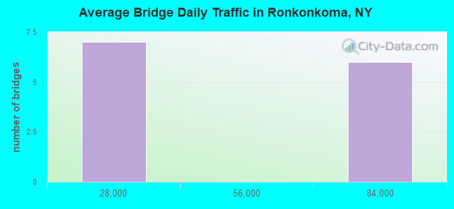
- 551,681Total average daily traffic
- 46,073Total average daily truck traffic
- National Bridge Inventory (NBI) Registered Bridges for Ronkonkoma
- No street view available for this location
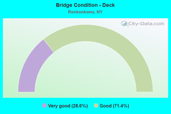
- Bridge Condition - Deck
- 28.6%Very good
- 71.4%Good
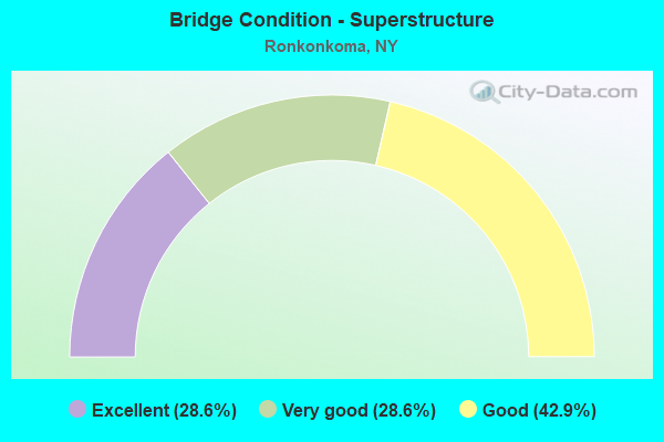
- Bridge Condition - Superstructure
- 28.6%Excellent
- 28.6%Very good
- 42.9%Good
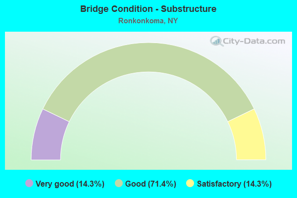
- Bridge Condition - Substructure
- 14.3%Very good
- 71.4%Good
- 14.3%Satisfactory
Find on map >> Show street view
Structure Number: 1049461, Location: 2 MI E JCT RTS 454 & I495 (Lat: 40.810833, Lng: -73.147247), Route carried "on" structure: Interstate 495, Year Built: 1998, Status: Open, Structure Length: 2.71m (8.89ft), Average Daily Traffic: 71,649 (year 1997), Truck Traffic: 13%, Design Load: HS 25 or greater, Features Intersected: TERRY ROAD
Minimum Vertical Clearance: 30+ m (98+ ft), Kilometerpoint: 25.664, Lanes on structure: 4, Lanes under structure: 2, Base Highway Network: Yes, Owner: State Highway Agency, Approaching Roadway Width: 22.9m (75.1ft), Skew: 1 degrees, Material/Design: Steel, Design/Construction: Stringer/Multi-beam, Number Of Spans In Main Unit: 1, Length of Maximum Span: 25.9m (85.0ft), Curb-To-Curb Width: 23.0m (75.5ft), Out-to-Out Width: 24.7m (81.0ft)
Condition: Deck: Very good, Superstructure: Excellent, Substructure: Good, Operating Rating: 65.3 metric tons, Method Used To Determine Operating Rating: Load Factor (LF), Inventory Rating: 40.8 metric tons, Method Used To Determine Inventory Rating: Load Factor (LF), Structural Evaluation: Better than present minimum criteria, Deck Geometry: Superior to present desirable criteria, Underclear: Somewhat better than minimum adequacy, Approach Roadway Alignment: Equal to present desirable criteria, Length Of Structure Improvement: 2.71m (8.89ft), Designated Inspection Frequency: Every 24 months, Inspection Date: March 2020, Bridge Improvement Cost: $4,154,000, Roadway Improvement Cost: $2,433,000, Total Project Cost: $6,587,000 ( Estimate for 2021), Deck Structure Type: Concrete Cast-file-Place, Wearing Surface/Protective System: Wearing Surface: Integral Concrete, Deck Protection: Epoxy Coated Reinforcing
Find on map >> Show street view
Structure Number: 1049462, Location: 2 MI E JCT RTS 454 & I495 (Lat: 40.810581, Lng: -73.147108), Route carried "on" structure: Interstate 495, Year Built: 1998, Status: Open, Structure Length: 2.71m (8.89ft), Average Daily Traffic: 73,086 (year 2018), Truck Traffic: 6%, Average Future Daily Traffic: 76,740 (year 2040), Design Load: HS 25 or greater, Features Intersected: TERRY ROAD
Minimum Vertical Clearance: 30+ m (98+ ft), Kilometerpoint: 25.664, Lanes on structure: 4, Lanes under structure: 2, Base Highway Network: Yes, Owner: State Highway Agency, Approaching Roadway Width: 24.1m (79.1ft), Skew: 1 degrees, Material/Design: Steel, Design/Construction: Stringer/Multi-beam, Number Of Spans In Main Unit: 1, Length of Maximum Span: 25.9m (85.0ft), Curb-To-Curb Width: 24.2m (79.4ft), Out-to-Out Width: 25.9m (85.0ft)
Condition: Deck: Very good, Superstructure: Excellent, Substructure: Satisfactory, Operating Rating: 65.3 metric tons, Method Used To Determine Operating Rating: Load Factor (LF), Inventory Rating: 40.8 metric tons, Method Used To Determine Inventory Rating: Load Factor (LF), Structural Evaluation: Equal to present minimum criteria, Deck Geometry: Superior to present desirable criteria, Underclear: Equal to present minimum criteria, Approach Roadway Alignment: Equal to present desirable criteria, Length Of Structure Improvement: 2.71m (8.89ft), Designated Inspection Frequency: Every 24 months, Inspection Date: March 2020, Bridge Improvement Cost: $4,415,000, Roadway Improvement Cost: $2,586,000, Total Project Cost: $7,001,000 ( Estimate for 2021), Deck Structure Type: Concrete Cast-file-Place, Wearing Surface/Protective System: Wearing Surface: Integral Concrete, Deck Protection: Epoxy Coated Reinforcing
Find on map >> Show street view
Structure Number: 1049471, Location: 3.1 MI E JCT RTS 454&I495 (Lat: 40.812458, Lng: -73.125056), Route carried "on" structure: Interstate 495, Year Built: 1998, Status: Open, Structure Length: 4.05m (13.29ft), Average Daily Traffic: 78,866 (year 2008), Truck Traffic: 13%, Design Load: HS 25 or greater, Features Intersected: OCEAN AVENUE
Minimum Vertical Clearance: 30+ m (98+ ft), Kilometerpoint: 27.530, Lanes on structure: 4, Lanes under structure: 4, Base Highway Network: Yes, Owner: State Highway Agency, Approaching Roadway Width: 23.2m (76.1ft), Material/Design: Steel, Design/Construction: Stringer/Multi-beam, Number Of Spans In Main Unit: 1, Length of Maximum Span: 39.0m (128.0ft), Curb-To-Curb Width: 23.0m (75.5ft), Out-to-Out Width: 24.0m (78.7ft)
Condition: Deck: Good, Superstructure: Good, Substructure: Good, Operating Rating: 84.4 metric tons, Method Used To Determine Operating Rating: Load Factor (LF), Inventory Rating: 40.8 metric tons, Method Used To Determine Inventory Rating: Load Factor (LF), Structural Evaluation: Better than present minimum criteria, Deck Geometry: Superior to present desirable criteria, Underclear: Equal to present minimum criteria, Approach Roadway Alignment: Equal to present desirable criteria, Length Of Structure Improvement: 4.05m (13.29ft), Designated Inspection Frequency: Every 24 months, Inspection Date: April 2021, Bridge Improvement Cost: $5,717,000, Roadway Improvement Cost: $3,348,000, Total Project Cost: $9,065,000 ( Estimate for 2021), Deck Structure Type: Concrete Cast-file-Place, Wearing Surface/Protective System: Wearing Surface: Integral Concrete, Deck Protection: Epoxy Coated Reinforcing
Find on map >> Show street view
Structure Number: 1049472, Location: 3.1 MI E JCT RTS 454&I495 (Lat: 40.812194, Lng: -73.125017), Route carried "on" structure: Interstate 495, Year Built: 1998, Status: Open, Structure Length: 4.05m (13.29ft), Average Daily Traffic: 81,156 (year 2020), Truck Traffic: 7%, Average Future Daily Traffic: 85,214 (year 2040), Design Load: HS 25 or greater, Features Intersected: OCEAN AVENUE
Minimum Vertical Clearance: 30+ m (98+ ft), Kilometerpoint: 27.530, Lanes on structure: 4, Lanes under structure: 4, Base Highway Network: Yes, Owner: State Highway Agency, Approaching Roadway Width: 24.1m (79.1ft), Material/Design: Steel, Design/Construction: Stringer/Multi-beam, Number Of Spans In Main Unit: 1, Length of Maximum Span: 39.0m (128.0ft), Curb-To-Curb Width: 24.2m (79.4ft), Out-to-Out Width: 25.2m (82.7ft)
Condition: Deck: Good, Superstructure: Good, Substructure: Very good, Operating Rating: 84.4 metric tons, Method Used To Determine Operating Rating: Load Factor (LF), Inventory Rating: 40.8 metric tons, Method Used To Determine Inventory Rating: Load Factor (LF), Structural Evaluation: Better than present minimum criteria, Deck Geometry: Superior to present desirable criteria, Underclear: Somewhat better than minimum adequacy, Approach Roadway Alignment: Equal to present desirable criteria, Length Of Structure Improvement: 4.05m (13.29ft), Designated Inspection Frequency: Every 24 months, Inspection Date: April 2021, Bridge Improvement Cost: $5,985,000, Roadway Improvement Cost: $3,505,000, Total Project Cost: $9,490,000 ( Estimate for 2021), Deck Structure Type: Concrete Cast-file-Place, Wearing Surface/Protective System: Wearing Surface: Integral Concrete, Deck Protection: Epoxy Coated Reinforcing
Find on map >> Show street view
Structure Number: 1049491, Location: 6.5 MI W JCT RTS I495&112 (Lat: 40.812761, Lng: -73.119189), Route carried "on" structure: Interstate 495, Year Built: 1998, Status: Open, Structure Length: 2.71m (8.89ft), Average Daily Traffic: 78,866 (year 2008), Truck Traffic: 13%, Design Load: HS 25 or greater, Features Intersected: POND ROAD
Minimum Vertical Clearance: 30+ m (98+ ft), Kilometerpoint: 28.029, Lanes on structure: 4, Lanes under structure: 2, Base Highway Network: Yes, Owner: State Highway Agency, Approaching Roadway Width: 22.9m (75.1ft), Skew: 1 degrees, Material/Design: Steel, Design/Construction: Stringer/Multi-beam, Number Of Spans In Main Unit: 1, Length of Maximum Span: 25.9m (85.0ft), Curb-To-Curb Width: 23.0m (75.5ft), Out-to-Out Width: 24.7m (81.0ft)
Condition: Deck: Good, Superstructure: Very good, Substructure: Good, Operating Rating: 84.4 metric tons, Method Used To Determine Operating Rating: Load Factor (LF), Inventory Rating: 40.8 metric tons, Method Used To Determine Inventory Rating: Load Factor (LF), Structural Evaluation: Better than present minimum criteria, Deck Geometry: Superior to present desirable criteria, Underclear: Somewhat better than minimum adequacy, Approach Roadway Alignment: Equal to present desirable criteria, Length Of Structure Improvement: 2.71m (8.89ft), Designated Inspection Frequency: Every 24 months, Inspection Date: May 2021, Bridge Improvement Cost: $4,314,000, Roadway Improvement Cost: $2,526,000, Total Project Cost: $6,840,000 ( Estimate for 2021), Deck Structure Type: Concrete Cast-file-Place, Wearing Surface/Protective System: Wearing Surface: Integral Concrete, Deck Protection: Epoxy Coated Reinforcing
Find on map >> Show street view
Structure Number: 1049492, Location: 6.5 MI W JCT RTS I495&112 (Lat: 40.812489, Lng: -73.119244), Route carried "on" structure: Interstate 495, Year Built: 1998, Status: Open, Structure Length: 2.71m (8.89ft), Average Daily Traffic: 81,156 (year 2020), Truck Traffic: 7%, Average Future Daily Traffic: 85,214 (year 2040), Design Load: HS 25 or greater, Features Intersected: POND ROAD
Minimum Vertical Clearance: 30+ m (98+ ft), Kilometerpoint: 28.029, Lanes on structure: 5, Lanes under structure: 2, Base Highway Network: Yes, Owner: State Highway Agency, Approaching Roadway Width: 26.5m (86.9ft), Skew: 1 degrees, Material/Design: Steel, Design/Construction: Stringer/Multi-beam, Number Of Spans In Main Unit: 1, Length of Maximum Span: 25.9m (85.0ft), Curb-To-Curb Width: 26.6m (87.3ft), Out-to-Out Width: 28.3m (92.8ft)
Condition: Deck: Good, Superstructure: Very good, Substructure: Good, Operating Rating: 84.4 metric tons, Method Used To Determine Operating Rating: Load Factor (LF), Inventory Rating: 40.8 metric tons, Method Used To Determine Inventory Rating: Load Factor (LF), Structural Evaluation: Better than present minimum criteria, Deck Geometry: Superior to present desirable criteria, Underclear: Meets minimum limits, Approach Roadway Alignment: Equal to present desirable criteria, Length Of Structure Improvement: 2.71m (8.89ft), Designated Inspection Frequency: Every 24 months, Inspection Date: May 2021, Bridge Improvement Cost: $4,953,000, Roadway Improvement Cost: $2,900,000, Total Project Cost: $7,853,000 ( Estimate for 2021), Deck Structure Type: Concrete Cast-file-Place, Wearing Surface/Protective System: Wearing Surface: Integral Concrete, Deck Protection: Epoxy Coated Reinforcing
Find on map >> Show street view
Structure Number: 226106, Location: IN RONKONKOMA (Lat: 40.807453, Lng: -73.111178), Route carried "on" structure: County highway , Year Built: 1990, Status: Open, Structure Length: 10.76m (35.30ft), Average Daily Traffic: 12,754 (year 2011), Truck Traffic: 4%, Average Future Daily Traffic: 15,780 (year 2040), Design Load: HS 20, Features Intersected: EASTON STREET, LIRR - MA, Facility Carried by Structure: RONKONKOMA AVENUE
Minimum Vertical Clearance: 30+ m (98+ ft), Kilometerpoint: 0.000, Lanes on structure: 4, Lanes under structure: 7, Owner: County Highway Agency, Approaching Roadway Width: 17.1m (56.1ft), Skew: 20 degrees, Material/Design: Steel continuous, Design/Construction: Stringer/Multi-beam, Number Of Spans In Main Unit: 4, Length of Maximum Span: 26.8m (87.9ft), Curb or Sidewalk Widths: Left: 0.0m, Right: 1.5m (4.9ft), Curb-To-Curb Width: 17.1m (56.1ft), Out-to-Out Width: 19.3m (63.3ft)
Condition: Deck: Good, Superstructure: Good, Substructure: Good, Operating Rating: 62.6 metric tons, Method Used To Determine Operating Rating: Load Factor (LF), Inventory Rating: 33.6 metric tons, Method Used To Determine Inventory Rating: Load Factor (LF), Structural Evaluation: Better than present minimum criteria, Deck Geometry: Somewhat better than minimum adequacy, Underclear: Somewhat better than minimum adequacy, Approach Roadway Alignment: Equal to present desirable criteria, Length Of Structure Improvement: 10.75m (35.27ft), Designated Inspection Frequency: Every 24 months, Inspection Date: September 2020, Bridge Improvement Cost: $8,956,000, Roadway Improvement Cost: $5,245,000, Total Project Cost: $14,201,000 ( Estimate for 2021), Deck Structure Type: Concrete Cast-file-Place, Wearing Surface/Protective System: Wearing Surface: Integral Concrete, Deck Protection: Epoxy Coated Reinforcing
Find on map >> Show street view
Structure Number: 1049461, Location: 2 MI E JCT RTS 454 & I495 (Lat: 40.810833, Lng: -73.147247), Route carried "under" structure: City street , Year Built: 1998, Structure Length: 0. m, Average Daily Traffic: 4,000 (year 2021), Features Intersected: TERRY ROAD, Facility Carried by Structure: RTE I495
Minimum Vertical Clearance: 4.49m (14.73ft), Kilometerpoint: 0.000, Lanes on structure: 4, Lanes under structure: 2, Material/Design: Steel, Design/Construction: Stringer/Multi-beam, Length of Maximum Span: 25.9m (85.0ft)
Find on map >> Show street view
Structure Number: 1049462, Location: 2 MI E JCT RTS 454 & I495 (Lat: 40.810581, Lng: -73.147108), Route carried "under" structure: City street , Year Built: 1998, Structure Length: 0. m, Average Daily Traffic: 4,000 (year 2021), Features Intersected: TERRY ROAD, Facility Carried by Structure: RTE I495
Minimum Vertical Clearance: 4.59m (15.06ft), Kilometerpoint: 0.000, Lanes on structure: 4, Lanes under structure: 2, Material/Design: Steel, Design/Construction: Stringer/Multi-beam, Length of Maximum Span: 25.9m (85.0ft)
Find on map >> Show street view
Structure Number: 1049471, Location: 3.1 MI E JCT RTS 454&I495 (Lat: 40.812458, Lng: -73.125056), Route carried "under" structure: County highway , Year Built: 1998, Structure Length: 0. m, Average Daily Traffic: 27,574 (year 2003), Features Intersected: OCEAN AVENUE, Facility Carried by Structure: RTE I495
Minimum Vertical Clearance: 4.62m (15.16ft), Kilometerpoint: 0.000, Lanes on structure: 4, Lanes under structure: 4, Material/Design: Steel, Design/Construction: Stringer/Multi-beam, Length of Maximum Span: 39.0m (128.0ft)
Find on map >> Show street view
Structure Number: 1049472, Location: 3.1 MI E JCT RTS 454&I495 (Lat: 40.812194, Lng: -73.125017), Route carried "under" structure: County highway , Year Built: 1998, Structure Length: 0. m, Average Daily Traffic: 27,574 (year 2003), Features Intersected: OCEAN AVENUE, Facility Carried by Structure: RTE I495
Minimum Vertical Clearance: 5.18m (16.99ft), Kilometerpoint: 0.000, Lanes on structure: 4, Lanes under structure: 4, Material/Design: Steel, Design/Construction: Stringer/Multi-beam, Length of Maximum Span: 39.0m (128.0ft)
Find on map >> Show street view
Structure Number: 1049491, Location: 6.5 MI W JCT RTS I495&112 (Lat: 40.812761, Lng: -73.119189), Route carried "under" structure: Other road , Year Built: 1998, Structure Length: 0. m, Average Daily Traffic: 5,500 (year 2021), Features Intersected: POND ROAD, Facility Carried by Structure: RTE I495
Minimum Vertical Clearance: 4.39m (14.40ft), Kilometerpoint: 0.000, Lanes on structure: 4, Lanes under structure: 2, Material/Design: Steel, Design/Construction: Stringer/Multi-beam, Length of Maximum Span: 25.9m (85.0ft)
Find on map >> Show street view
Structure Number: 1049492, Location: 6.5 MI W JCT RTS I495&112 (Lat: 40.812489, Lng: -73.119244), Route carried "under" structure: Other road , Year Built: 1998, Structure Length: 0. m, Average Daily Traffic: 5,500 (year 2021), Features Intersected: POND ROAD, Facility Carried by Structure: RTE I495
Minimum Vertical Clearance: 4.59m (15.06ft), Kilometerpoint: 0.000, Lanes on structure: 5, Lanes under structure: 2, Material/Design: Steel, Design/Construction: Stringer/Multi-beam, Length of Maximum Span: 25.9m (85.0ft)
Find on map >> Show street view
Structure Number: 226106, Location: IN RONKONKOMA (Lat: 40.807453, Lng: -73.111178), Route carried "under" structure: City street , Year Built: 1990, Structure Length: 0. m, Features Intersected: EASTON STREET, LIRR - MA, Facility Carried by Structure: RONKONKOMA AVENUE
Minimum Vertical Clearance: 5.49m (18.01ft), Kilometerpoint: 0.000, Lanes on structure: 4, Lanes under structure: 3, Material/Design: Steel continuous, Design/Construction: Stringer/Multi-beam, Length of Maximum Span: 26.8m (87.9ft)