Bridge Statistics for Rye Brook, New York (NY)
Condition, Traffic, Stress, Structural Evaluation, Project Costs
- National Bridge Inventory (NBI) Statistics
- 11Number of bridges
- 56ft / 17.2mTotal length
- $25,502,000Total costs
- 349,438Total average daily traffic
- 12,345Total average daily truck traffic
- National Bridge Inventory (NBI) Registered Bridges for Rye Brook
- No street view available for this location
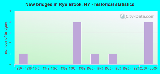
- New bridges - historical statistics
- 11930-1939
- 41960-1969
- 11970-1979
- 11980-1989
- 42000-2009


- Bridge Condition - Deck
- 20.0%Excellent
- 60.0%Satisfactory
- 20.0%Fair

- Bridge Condition - Superstructure
- 25.0%Good
- 75.0%Satisfactory

- Bridge Condition - Substructure
- 37.5%Good
- 50.0%Satisfactory
- 12.5%Fair

- Bridge Condition - Channel
- 14.3%Excellent
- 42.9%Satisfactory
- 42.9%Fair
Find on map >> Show street view
Structure Number: 1044869, Location: 1.9 MI E JCT RTE I287+HRP (Lat: 41.000603, Lng: -73.684814), Route carried "on" structure: Interstate 287, Year Built: 1960, Status: Open, Structure Length: 1.68m (5.51ft), Average Daily Traffic: 73,478 (year 2019), Truck Traffic: 15%, Average Future Daily Traffic: 124,427 (year 2040), Design Load: HS 20+Mod, Features Intersected: BLIND BROOK
Minimum Vertical Clearance: 30+ m (98+ ft), Kilometerpoint: 21.255, Lanes on structure: 6, Base Highway Network: Yes, Owner: State Highway Agency, Approaching Roadway Width: 34.1m (111.9ft), Skew: 22 degrees, Material/Design: Concrete continuous, Design/Construction: Culvert, Number Of Spans In Main Unit: 3, Length of Maximum Span: 4.8m (15.7ft)
Condition: Channel: Satisfactory, Culverts: Satisfactory, Operating Rating: 97.2 metric tons, Method Used To Determine Operating Rating: Load and Resistance Factor Rating (LRFR) rating reported by rating factor(RF) method using HL-93 loadings, Inventory Rating: 97.2 metric tons, Method Used To Determine Inventory Rating: Load and Resistance Factor Rating (LRFR) rating reported by rating factor(RF) method using HL-93 loadings, Structural Evaluation: Equal to present minimum criteria, Waterway Adequacy: High priority of corrective action, Approach Roadway Alignment: Equal to present desirable criteria, Length Of Structure Improvement: 1.67m (5.48ft), Designated Inspection Frequency: Every 24 months, Inspection Date: May 2020, Bridge Improvement Cost: $1,964,000, Roadway Improvement Cost: $1,150,000, Total Project Cost: $3,114,000 ( Estimate for 2021), Wearing Surface/Protective System: Wearing Surface: Bituminous
Find on map >> Show street view
Structure Number: 104487, Location: 2 MI E JCT I287 & HRP (Lat: 40.998758, Lng: -73.681656), Route carried "on" structure: County highway , Year Built: 1960, Year Reconstructed: 1997, Status: Open, Structure Length: 5.67m (18.60ft), Average Daily Traffic: 9,608 (year 2016), Truck Traffic: 2%, Average Future Daily Traffic: 11,671 (year 2040), Design Load: HS 20+Mod, Features Intersected: 287IX - WB, RTE I287, Facility Carried by Structure: RIDGE STREET
Minimum Vertical Clearance: 30+ m (98+ ft), Kilometerpoint: 1.110, Lanes on structure: 4, Lanes under structure: 6, Owner: State Highway Agency, Approaching Roadway Width: 19.5m (64.0ft), Skew: 2 degrees, Material/Design: Steel continuous, Design/Construction: Stringer/Multi-beam, Number Of Spans In Main Unit: 2, Length of Maximum Span: 27.1m (88.9ft), Curb or Sidewalk Widths: Left: 1.5m (4.9ft), Right: 1.5m (4.9ft), Curb-To-Curb Width: 14.6m (47.9ft), Out-to-Out Width: 18.3m (60.0ft)
Condition: Deck: Excellent, Superstructure: Good, Substructure: Satisfactory, Operating Rating: 66.2 metric tons, Method Used To Determine Operating Rating: Load Factor (LF), Inventory Rating: 39.0 metric tons, Method Used To Determine Inventory Rating: Load Factor (LF), Structural Evaluation: Equal to present minimum criteria, Deck Geometry: High priority of replacement, Underclear: Meets minimum limits, Approach Roadway Alignment: Equal to present desirable criteria, Length Of Structure Improvement: 5.66m (18.57ft), Designated Inspection Frequency: Every 24 months, Inspection Date: November 2021, Bridge Improvement Cost: $4,215,000, Roadway Improvement Cost: $2,468,000, Total Project Cost: $6,683,000 ( Estimate for 2021), Deck Structure Type: Concrete Cast-file-Place, Wearing Surface/Protective System: Wearing Surface: Integral Concrete, Deck Protection: Epoxy Coated Reinforcing
Find on map >> Show street view
Structure Number: 107746, Location: 80M SE OF LINCOLN AV &HRP (Lat: 41.023061, Lng: -73.694214), Route carried "on" structure: Ramp Other road , Year Built: 2000, Status: Open, Structure Length: 1.34m (4.40ft), Design Load: HS 25 or greater, Features Intersected: BLIND BROOK, Facility Carried by Structure: RAMP-F HRP XT 28
Minimum Vertical Clearance: 30+ m (98+ ft), Kilometerpoint: 0.000, Lanes on structure: 1, Owner: State Highway Agency, Approaching Roadway Width: 6.6m (21.7ft), Skew: 4 degrees, Material/Design: Concrete, Design/Construction: Frame, Number Of Spans In Main Unit: 1, Length of Maximum Span: 11.9m (39.0ft), Curb-To-Curb Width: 6.6m (21.7ft), Out-to-Out Width: 9.4m (30.8ft)
Condition: Superstructure: Satisfactory, Substructure: Good, Channel: Fair, Operating Rating: 69.9 metric tons, Method Used To Determine Operating Rating: Load Factor (LF), Inventory Rating: 41.7 metric tons, Method Used To Determine Inventory Rating: Load Factor (LF), Structural Evaluation: Equal to present minimum criteria, Deck Geometry: Somewhat better than minimum adequacy, Waterway Adequacy: Meets minimum limits, Approach Roadway Alignment: Equal to present desirable criteria, Length Of Structure Improvement: 1.34m (4.40ft), Designated Inspection Frequency: Every 24 months, Inspection Date: May 2021, Bridge Improvement Cost: $523,000, Roadway Improvement Cost: $306,000, Total Project Cost: $829,000 ( Estimate for 2021)
Find on map >> Show street view
Structure Number: 226236, Location: 1.7 MI NW OF PORT CHESTER (Lat: 41.021233, Lng: -73.694189), Route carried "on" structure: Other road , Year Built: 1962, Status: Open, Structure Length: 1.16m (3.81ft), Truck Traffic: 3%, Features Intersected: BLIND BROOK, Facility Carried by Structure: BROOKSIDE WAY
Minimum Vertical Clearance: 30+ m (98+ ft), Kilometerpoint: 0.016, Lanes on structure: 2, Owner: Town or Township Highway Agency, Approaching Roadway Width: 8.5m (27.9ft), Skew: 3 degrees, Material/Design: Concrete, Design/Construction: Slab, Number Of Spans In Main Unit: 1, Length of Maximum Span: 10.9m (35.8ft), Curb or Sidewalk Widths: Left: 0.3m (1.0ft), Right: 1.2m (3.9ft), Curb-To-Curb Width: 8.6m (28.2ft), Out-to-Out Width: 10.8m (35.4ft)
Condition: Deck: Satisfactory, Superstructure: Satisfactory, Substructure: Fair, Channel: Fair, Operating Rating: 59.9 metric tons, Method Used To Determine Operating Rating: Load and Resistance Factor Rating (LRFR) rating reported by rating factor(RF) method using HL-93 loadings, Inventory Rating: 46.3 metric tons, Method Used To Determine Inventory Rating: Load and Resistance Factor Rating (LRFR) rating reported by rating factor(RF) method using HL-93 loadings, Structural Evaluation: Somewhat better than minimum adequacy, Deck Geometry: Better than present minimum criteria, Waterway Adequacy: Meets minimum limits, Approach Roadway Alignment: Equal to present desirable criteria, Length Of Structure Improvement: 1.15m (3.77ft), Designated Inspection Frequency: Every 24 months, Inspection Date: June 2021, Bridge Improvement Cost: $598,000, Roadway Improvement Cost: $350,000, Total Project Cost: $949,000 ( Estimate for 2021), Wearing Surface/Protective System: Wearing Surface: Bituminous
Find on map >> Show street view
Structure Number: 334849, Location: 1.6 MI NW OF PORT CHESTER (Lat: 41.020300, Lng: -73.694364), Route carried "on" structure: County highway , Year Built: 1973, Year Reconstructed: 2003, Status: Open, Structure Length: 1.49m (4.89ft), Average Daily Traffic: 3,215 (year 2019), Truck Traffic: 3%, Average Future Daily Traffic: 3,905 (year 2040), Features Intersected: BLIND BROOK, Facility Carried by Structure: LINCOLN AVENUE
Minimum Vertical Clearance: 30+ m (98+ ft), Kilometerpoint: 0.016, Lanes on structure: 2, Owner: County Highway Agency, Approaching Roadway Width: 6.7m (22.0ft), Skew: 3 degrees, Material/Design: Steel, Design/Construction: Stringer/Multi-beam, Number Of Spans In Main Unit: 1, Length of Maximum Span: 14.0m (45.9ft), Curb or Sidewalk Widths: Left: 1.5m (4.9ft), Right: 0.0m, Curb-To-Curb Width: 7.3m (24.0ft), Out-to-Out Width: 9.6m (31.5ft)
Condition: Deck: Fair, Superstructure: Satisfactory, Substructure: Good, Channel: Fair, Operating Rating: 47.2 metric tons, Method Used To Determine Operating Rating: Load Factor (LF), Inventory Rating: 28.1 metric tons, Method Used To Determine Inventory Rating: Load Factor (LF), Structural Evaluation: Equal to present minimum criteria, Deck Geometry: High priority of replacement, Waterway Adequacy: Meets minimum limits, Approach Roadway Alignment: Equal to present desirable criteria, Length Of Structure Improvement: 1.49m (4.89ft), Designated Inspection Frequency: Every 24 months, Inspection Date: March 2021, Bridge Improvement Cost: $983,000, Roadway Improvement Cost: $575,000, Total Project Cost: $1,558,000 ( Estimate for 2021), Deck Structure Type: Concrete Cast-file-Place, Wearing Surface/Protective System: Wearing Surface: Bituminous, Membrane: Other
Find on map >> Show street view
Structure Number: 334851, Location: 1.7 MI NW OF PORT CHESTER (Lat: 41.019592, Lng: -73.694967), Route carried "on" structure: Other road , Year Built: 1983, Status: Open, Structure Length: 0.98m (3.22ft), Average Daily Traffic: 144 (year 2019), Truck Traffic: 4%, Average Future Daily Traffic: 202 (year 2039), Design Load: HS 20, Features Intersected: BLIND BROOK, Facility Carried by Structure: WESTERLEIGH ROAD
Minimum Vertical Clearance: 30+ m (98+ ft), Kilometerpoint: 0.000, Lanes on structure: 2, Owner: County Highway Agency, Approaching Roadway Width: 4.9m (16.1ft), Skew: 2 degrees, Material/Design: Prestressed concrete, Design/Construction: Box Beam or Girders - Multiple, Number Of Spans In Main Unit: 1, Length of Maximum Span: 8.5m (27.9ft), Curb-To-Curb Width: 4.9m (16.1ft), Out-to-Out Width: 5.5m (18.0ft)
Condition: Deck: Satisfactory, Superstructure: Satisfactory, Substructure: Satisfactory, Channel: Excellent, Operating Rating: 46.3 metric tons, Method Used To Determine Operating Rating: Load Factor (LF), Inventory Rating: 21.8 metric tons, Method Used To Determine Inventory Rating: Load Factor (LF), Structural Evaluation: Equal to present minimum criteria, Deck Geometry: High priority of replacement, Waterway Adequacy: Somewhat better than minimum adequacy, Approach Roadway Alignment: Meets minimum limits, Length Of Structure Improvement: 0.97m (3.18ft), Designated Inspection Frequency: Every 24 months, Inspection Date: June 2021, Bridge Improvement Cost: $288,000, Roadway Improvement Cost: $169,000, Total Project Cost: $456,000 ( Estimate for 2021), Wearing Surface/Protective System: Wearing Surface: Bituminous
Find on map >> Show street view
Structure Number: 550031, Location: 1.5 MI E JCT HRP & RT 120 (Lat: 41.028297, Lng: -73.683444), Route carried "on" structure: County highway , Year Built: 2001, Status: Open, Structure Length: 3.41m (11.19ft), Average Daily Traffic: 4,979 (year 2020), Truck Traffic: 2%, Average Future Daily Traffic: 6,048 (year 2040), Design Load: HS 25 or greater, Features Intersected: 907W 907W87025035 SB, RT, Facility Carried by Structure: NORTH RIDGE STRET
Minimum Vertical Clearance: 30+ m (98+ ft), Kilometerpoint: 4.682, Lanes on structure: 2, Lanes under structure: 4, Owner: State Highway Agency, Approaching Roadway Width: 10.1m (33.1ft), Skew: 4 degrees, Material/Design: Concrete continuous, Design/Construction: Frame, Number Of Spans In Main Unit: 2, Length of Maximum Span: 15.5m (50.9ft), Curb or Sidewalk Widths: Left: 1.5m (4.9ft), Right: 0.0m, Curb-To-Curb Width: 10.2m (33.5ft), Out-to-Out Width: 13.0m (42.7ft)
Condition: Deck: Satisfactory, Superstructure: Satisfactory, Substructure: Good, Operating Rating: 83.6 metric tons, Method Used To Determine Operating Rating: Field evaluation and documented engineering judgment, Inventory Rating: 40.8 metric tons, Method Used To Determine Inventory Rating: Field evaluation and documented engineering judgment, Structural Evaluation: Equal to present minimum criteria, Deck Geometry: Meets minimum limits, Underclear: High priority of corrective action, Approach Roadway Alignment: Equal to present desirable criteria, Length Of Structure Improvement: 3.41m (11.19ft), Designated Inspection Frequency: Every 24 months, Inspection Date: June 2021, Bridge Improvement Cost: $3,137,000, Roadway Improvement Cost: $1,837,000, Total Project Cost: $4,975,000 ( Estimate for 2021), Wearing Surface/Protective System: Wearing Surface: Integral Concrete
Find on map >> Show street view
Structure Number: 552438, Location: 0.7 MI E JCT HRP EXIT 28 (Lat: 41.024464, Lng: -73.692594), Route carried "on" structure: Other road 907W, Year Built: 2001, Status: Open, Structure Length: 0.67m (2.20ft), Average Daily Traffic: 46,625 (year 2020), Truck Traffic: 1%, Average Future Daily Traffic: 65,773 (year 2040), Design Load: HS 25 or greater, Features Intersected: BLIND BROOK
Minimum Vertical Clearance: 30+ m (98+ ft), Kilometerpoint: 20.901, Lanes on structure: 5, Base Highway Network: Yes, Owner: State Highway Agency, Approaching Roadway Width: 22.8m (74.8ft), Skew: 25 degrees, Material/Design: Concrete, Design/Construction: Frame, Number Of Spans In Main Unit: 1, Length of Maximum Span: 6.1m (20.0ft), Curb-To-Curb Width: 22.8m (74.8ft), Out-to-Out Width: 46.2m (151.6ft)
Condition: Superstructure: Good, Substructure: Satisfactory, Channel: Satisfactory, Operating Rating: 73.5 metric tons, Method Used To Determine Operating Rating: Load Factor (LF), Inventory Rating: 43.5 metric tons, Method Used To Determine Inventory Rating: Load Factor (LF), Structural Evaluation: Equal to present minimum criteria, Deck Geometry: Somewhat better than minimum adequacy, Waterway Adequacy: Meets minimum limits, Approach Roadway Alignment: Equal to present desirable criteria, Length Of Structure Improvement: 0.67m (2.20ft), Designated Inspection Frequency: Every 24 months, Inspection Date: April 2021, Bridge Improvement Cost: $2,670,000, Roadway Improvement Cost: $1,563,000, Total Project Cost: $4,233,000 ( Estimate for 2021)
Find on map >> Show street view
Structure Number: 552439, Location: .9 MI E JCT HRP EXIT 28 (Lat: 41.026258, Lng: -73.690539), Route carried "on" structure: Other road 907W, Year Built: 1936, Status: Open, Structure Length: 0.79m (2.59ft), Average Daily Traffic: 46,625 (year 2020), Truck Traffic: 1%, Average Future Daily Traffic: 65,773 (year 2040), Design Load: H 20, Features Intersected: BLIND BROOK
Minimum Vertical Clearance: 30+ m (98+ ft), Kilometerpoint: 21.255, Lanes on structure: 4, Base Highway Network: Yes, Owner: State Highway Agency, Approaching Roadway Width: 19.5m (64.0ft), Skew: 24 degrees, Material/Design: Concrete, Design/Construction: Frame, Number Of Spans In Main Unit: 1, Length of Maximum Span: 7.6m (24.9ft), Curb-To-Curb Width: 20.9m (68.6ft), Out-to-Out Width: 36.6m (120.1ft)
Condition: Superstructure: Satisfactory, Substructure: Satisfactory, Channel: Satisfactory, Operating Rating: 44.5 metric tons, Method Used To Determine Operating Rating: Load Factor (LF), Inventory Rating: 26.3 metric tons, Method Used To Determine Inventory Rating: Load Factor (LF), Structural Evaluation: Equal to present minimum criteria, Deck Geometry: Better than present minimum criteria, Waterway Adequacy: Meets minimum limits, Approach Roadway Alignment: Equal to present desirable criteria, Length Of Structure Improvement: 0.79m (2.59ft), Designated Inspection Frequency: Every 24 months, Inspection Date: May 2021, Bridge Improvement Cost: $1,706,000, Roadway Improvement Cost: $999,000, Total Project Cost: $2,705,000 ( Estimate for 2021)
Find on map >> Show street view
Structure Number: 104487, Location: 2 MI E JCT I287 & HRP (Lat: 40.998758, Lng: -73.681656), Route carried "under" structure: Interstate 287, Year Built: 1960, Structure Length: 0. m, Average Daily Traffic: 122,164 (year 2002), Features Intersected: 287IX - WB, RTE I287, Facility Carried by Structure: RIDGE STREET
Minimum Vertical Clearance: 5.46m (17.91ft), Kilometerpoint: 15.736, Lanes on structure: 4, Lanes under structure: 3, Material/Design: Steel continuous, Design/Construction: Stringer/Multi-beam, Length of Maximum Span: 27.1m (88.9ft)
Find on map >> Show street view
Structure Number: 550031, Location: 1.5 MI E JCT HRP & RT 120 (Lat: 41.028297, Lng: -73.683444), Route carried "under" structure: Other road 907W, Year Built: 2001, Structure Length: 0. m, Average Daily Traffic: 42,600 (year 1997), Features Intersected: 907W 907W87025035 SB, RT, Facility Carried by Structure: NORTH RIDGE STRET
Minimum Vertical Clearance: 5.38m (17.65ft), Kilometerpoint: 22.043, Lanes on structure: 2, Lanes under structure: 2, Material/Design: Concrete continuous, Design/Construction: Frame, Length of Maximum Span: 15.5m (50.9ft)