Bridge Statistics for Salem, New York (NY)
Condition, Traffic, Stress, Structural Evaluation, Project Costs
- National Bridge Inventory (NBI) Statistics
- 19Number of bridges
- 128ft / 38.8mTotal length
- $20,998,000Total costs
- 9,396Total average daily traffic
- 767Total average daily truck traffic
- 11,477Total future (year 2038) average daily traffic
- National Bridge Inventory (NBI) Registered Bridges for Salem
- No street view available for this location
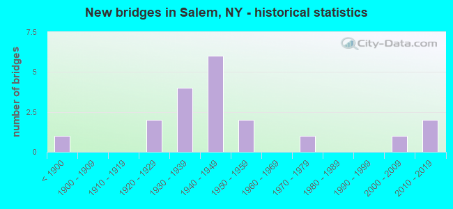
- New bridges - historical statistics
- 1Before 1900
- 21920-1929
- 41930-1939
- 61940-1949
- 21950-1959
- 11970-1979
- 12000-2009
- 22010-2019

- Reconstructed bridges - Historical Statistics
- 41980-1989
- 51990-1999
- 42000-2009


- Bridge Condition - Deck
- 5.3%Excellent
- 21.1%Very good
- 47.4%Good
- 15.8%Satisfactory
- 10.5%Fair

- Bridge Condition - Superstructure
- 5.3%Excellent
- 47.4%Very good
- 10.5%Good
- 21.1%Satisfactory
- 10.5%Fair
- 5.3%Serious

- Bridge Condition - Substructure
- 15.8%Very good
- 10.5%Good
- 42.1%Satisfactory
- 21.1%Fair
- 5.3%Poor
- 5.3%Serious

- Bridge Condition - Channel
- 5.3%Very good
- 42.1%Good
- 15.8%Satisfactory
- 36.8%Fair
Find on map >> Show street view
Structure Number: 101708, Location: 0.1 MI S JCT RTES 22& 153 (Lat: 43.170744, Lng: -73.326867), Route carried "on" structure: State highway 22, Year Built: 1928, Year Reconstructed: 2006, Status: Open, Structure Length: 1.37m (4.49ft), Average Daily Traffic: 3,146 (year 2019), Truck Traffic: 11%, Average Future Daily Traffic: 3,355 (year 2040), Design Load: HS 25 or greater, Features Intersected: WHITE CREEK
Minimum Vertical Clearance: 30+ m (98+ ft), Kilometerpoint: 27.433, Lanes on structure: 2, Base Highway Network: Yes, Owner: State Highway Agency, Approaching Roadway Width: 9.1m (29.9ft), Skew: 1 degrees, Material/Design: Prestressed concrete, Design/Construction: Box Beam or Girders - Multiple, Number Of Spans In Main Unit: 1, Length of Maximum Span: 13.1m (43.0ft), Curb or Sidewalk Widths: Left: 1.7m (5.6ft), Right: 1.7m (5.6ft), Curb-To-Curb Width: 9.0m (29.5ft), Out-to-Out Width: 13.2m (43.3ft)
Condition: Deck: Good, Superstructure: Very good, Substructure: Good, Channel: Good, Inventory Rating: 65.3 metric tons, Method Used To Determine Inventory Rating: Load Factor (LF), Structural Evaluation: Better than present minimum criteria, Deck Geometry: Meets minimum limits, Waterway Adequacy: Somewhat better than minimum adequacy, Approach Roadway Alignment: Equal to present desirable criteria, Length Of Structure Improvement: 1.37m (4.49ft), Designated Inspection Frequency: Every 24 months, Inspection Date: June 2020, Bridge Improvement Cost: $887,000, Roadway Improvement Cost: $519,000, Total Project Cost: $1,406,000 ( Estimate for 2021), Deck Structure Type: Concrete Cast-file-Place, Wearing Surface/Protective System: Wearing Surface: Integral Concrete, Deck Protection: Epoxy Coated Reinforcing
Find on map >> Show street view
Structure Number: 102073, Location: 1.2 MI E JCT 20 &BATTEN K (Lat: 43.149931, Lng: -73.384939), Route carried "on" structure: State highway 29, Year Built: 2013, Status: Open, Structure Length: 3.72m (12.20ft), Average Daily Traffic: 1,750 (year 2016), Truck Traffic: 11%, Average Future Daily Traffic: 1,825 (year 2040), Design Load: HL 93, Features Intersected: BLACK CREEK
Minimum Vertical Clearance: 30+ m (98+ ft), Kilometerpoint: 21.641, Lanes on structure: 2, Base Highway Network: Yes, Owner: State Highway Agency, Approaching Roadway Width: 9.1m (29.9ft), Skew: 4 degrees, Material/Design: Steel, Design/Construction: Stringer/Multi-beam, Number Of Spans In Main Unit: 1, Length of Maximum Span: 36.6m (120.1ft), Curb-To-Curb Width: 9.1m (29.9ft), Out-to-Out Width: 10.1m (33.1ft)
Condition: Deck: Good, Superstructure: Very good, Substructure: Very good, Channel: Very good, Operating Rating: 80.7 metric tons, Method Used To Determine Operating Rating: Load Factor (LF), Inventory Rating: 48.1 metric tons, Method Used To Determine Inventory Rating: Load Factor (LF), Structural Evaluation: Equal to present desirable criteria, Deck Geometry: Somewhat better than minimum adequacy, Waterway Adequacy: Superior to present desirable criteria, Approach Roadway Alignment: Meets minimum limits, Length Of Structure Improvement: 3.71m (12.17ft), Designated Inspection Frequency: Every 24 months, Inspection Date: October 2021, Bridge Improvement Cost: $943,000, Roadway Improvement Cost: $552,000, Total Project Cost: $1,495,000 ( Estimate for 2021), Deck Structure Type: Concrete Cast-file-Place, Wearing Surface/Protective System: Wearing Surface: Integral Concrete, Deck Protection: Epoxy Coated Reinforcing
Find on map >> Show street view
Structure Number: 320371, Location: 1.8 MI WNW OF SALEM (Lat: 43.176697, Lng: -73.368200), Route carried "on" structure: Other road , Year Built: 1958, Status: Open, Structure Length: 1.74m (5.71ft), Average Daily Traffic: 116 (year 2018), Truck Traffic: 5%, Average Future Daily Traffic: 162 (year 2038), Design Load: H 15, Features Intersected: BLACK CREEK, Facility Carried by Structure: MCKINNEY ROAD
Minimum Vertical Clearance: 30+ m (98+ ft), Kilometerpoint: 0.048, Lanes on structure: 2, Owner: County Highway Agency, Approaching Roadway Width: 6.1m (20.0ft), Skew: 2 degrees, Material/Design: Steel, Design/Construction: Stringer/Multi-beam, Number Of Spans In Main Unit: 1, Length of Maximum Span: 16.7m (54.8ft), Curb-To-Curb Width: 7.6m (24.9ft), Out-to-Out Width: 7.8m (25.6ft)
Condition: Deck: Good, Superstructure: Satisfactory, Substructure: Serious, Channel: Satisfactory, Operating Rating: 31.1 metric tons, Method Used To Determine Operating Rating: Load and Resistance Factor Rating (LRFR) rating reported by rating factor(RF) method using HL-93 loadings, Inventory Rating: 24.0 metric tons, Method Used To Determine Inventory Rating: Load and Resistance Factor Rating (LRFR) rating reported by rating factor(RF) method using HL-93 loadings, Structural Evaluation: High priority of corrective action, Deck Geometry: Somewhat better than minimum adequacy, Waterway Adequacy: Superior to present desirable criteria, Approach Roadway Alignment: Somewhat better than minimum adequacy, Length Of Structure Improvement: 1.73m (5.68ft), Designated Inspection Frequency: Every 24 months, Inspection Date: August 2021, Bridge Improvement Cost: $375,000, Roadway Improvement Cost: $220,000, Total Project Cost: $594,000 ( Estimate for 2021), Deck Structure Type: Concrete Cast-file-Place, Wearing Surface/Protective System: Wearing Surface: Bituminous
Find on map >> Show street view
Structure Number: 320372, Location: 2.5 MI S OF WEST HEBRON (Lat: 43.187419, Lng: -73.377047), Route carried "on" structure: Other road , Year Built: 1973, Status: Open, Structure Length: 1.65m (5.41ft), Average Daily Traffic: 235 (year 2018), Truck Traffic: 7%, Average Future Daily Traffic: 329 (year 2038), Design Load: H 15, Features Intersected: BLACK CREEK, Facility Carried by Structure: BLACK CREEK ROAD
Minimum Vertical Clearance: 30+ m (98+ ft), Kilometerpoint: 5.149, Lanes on structure: 2, Owner: County Highway Agency, Approaching Roadway Width: 7.7m (25.3ft), Skew: 3 degrees, Material/Design: Steel, Design/Construction: Stringer/Multi-beam, Number Of Spans In Main Unit: 1, Length of Maximum Span: 15.5m (50.9ft), Curb-To-Curb Width: 9.0m (29.5ft), Out-to-Out Width: 9.1m (29.9ft)
Condition: Deck: Good, Superstructure: Good, Substructure: Satisfactory, Channel: Good, Operating Rating: 87.1 metric tons, Method Used To Determine Operating Rating: Load Factor (LF), Inventory Rating: 51.7 metric tons, Method Used To Determine Inventory Rating: Load Factor (LF), Structural Evaluation: Equal to present minimum criteria, Deck Geometry: Equal to present minimum criteria, Waterway Adequacy: Superior to present desirable criteria, Approach Roadway Alignment: Meets minimum limits, Length Of Structure Improvement: 1.64m (5.38ft), Designated Inspection Frequency: Every 24 months, Inspection Date: August 2021, Bridge Improvement Cost: $680,000, Roadway Improvement Cost: $398,000, Total Project Cost: $1,079,000 ( Estimate for 2021), Deck Structure Type: Concrete Cast-file-Place, Wearing Surface/Protective System: Wearing Surface: Bituminous
Find on map >> Show street view
Structure Number: 320373, Location: 2 MI_SW OF SALEM (Lat: 43.160806, Lng: -73.369892), Route carried "on" structure: Other road , Year Built: 1930, Year Reconstructed: 1991, Status: Open, Structure Length: 2.44m (8.01ft), Average Daily Traffic: 251 (year 2019), Truck Traffic: 4%, Average Future Daily Traffic: 351 (year 2039), Design Load: HS 25 or greater, Features Intersected: BLACK CREEK, Facility Carried by Structure: CEMETERY ROAD
Minimum Vertical Clearance: 30+ m (98+ ft), Kilometerpoint: 0.048, Lanes on structure: 2, Owner: County Highway Agency, Approaching Roadway Width: 7.9m (25.9ft), Skew: 1 degrees, Material/Design: Prestressed concrete, Design/Construction: Box Beam or Girders - Multiple, Number Of Spans In Main Unit: 1, Length of Maximum Span: 24.0m (78.7ft), Curb-To-Curb Width: 7.9m (25.9ft), Out-to-Out Width: 8.7m (28.5ft)
Condition: Deck: Good, Superstructure: Very good, Substructure: Satisfactory, Channel: Good, Operating Rating: 89.8 metric tons, Method Used To Determine Operating Rating: Load Factor (LF), Inventory Rating: 45.4 metric tons, Method Used To Determine Inventory Rating: Load Factor (LF), Structural Evaluation: Equal to present minimum criteria, Deck Geometry: Somewhat better than minimum adequacy, Waterway Adequacy: Superior to present desirable criteria, Approach Roadway Alignment: Equal to present minimum criteria, Length Of Structure Improvement: 2.43m (7.97ft), Designated Inspection Frequency: Every 24 months, Inspection Date: August 2021, Bridge Improvement Cost: $818,000, Roadway Improvement Cost: $479,000, Total Project Cost: $1,298,000 ( Estimate for 2021), Deck Structure Type: Concrete Cast-file-Place, Wearing Surface/Protective System: Wearing Surface: Integral Concrete
Find on map >> Show street view
Structure Number: 330581, Location: 5 MILES NE OF SALEM (Lat: 43.222278, Lng: -73.270375), Route carried "on" structure: County highway , Year Built: 1928, Year Reconstructed: 2002, Status: Open, Structure Length: 1.80m (5.91ft), Average Daily Traffic: 628 (year 2018), Truck Traffic: 6%, Average Future Daily Traffic: 879 (year 2038), Design Load: HS 25 or greater, Features Intersected: WHITE CREEK, Facility Carried by Structure: COUNTY ROAD 153
Minimum Vertical Clearance: 30+ m (98+ ft), Kilometerpoint: 7.627, Lanes on structure: 2, Owner: County Highway Agency, Approaching Roadway Width: 7.6m (24.9ft), Skew: 4 degrees, Material/Design: Steel, Design/Construction: Stringer/Multi-beam, Number Of Spans In Main Unit: 1, Length of Maximum Span: 17.6m (57.7ft), Curb-To-Curb Width: 7.6m (24.9ft), Out-to-Out Width: 8.2m (26.9ft)
Condition: Deck: Good, Superstructure: Satisfactory, Substructure: Poor, Channel: Fair, Operating Rating: 85.2 metric tons, Method Used To Determine Operating Rating: Field evaluation and documented engineering judgment, Inventory Rating: 40.8 metric tons, Method Used To Determine Inventory Rating: Field evaluation and documented engineering judgment, Structural Evaluation: Meets minimum limits, Deck Geometry: Meets minimum limits, Waterway Adequacy: Superior to present desirable criteria, Approach Roadway Alignment: Equal to present minimum criteria, Length Of Structure Improvement: 1.79m (5.87ft), Designated Inspection Frequency: Every 24 months, Inspection Date: June 2021, Bridge Improvement Cost: $580,000, Roadway Improvement Cost: $340,000, Total Project Cost: $920,000 ( Estimate for 2021), Deck Structure Type: Other, Wearing Surface/Protective System: Wearing Surface: Bituminous
Find on map >> Show street view
Structure Number: 330592, Location: 3.5 MI SE JCT SH22 & SH29 (Lat: 43.099550, Lng: -73.302933), Route carried "on" structure: County highway , Year Built: 2014, Status: Open, Structure Length: 3.75m (12.30ft), Average Daily Traffic: 596 (year 2019), Truck Traffic: 5%, Average Future Daily Traffic: 834 (year 2039), Design Load: H 20, Features Intersected: BATTEN KILL, Facility Carried by Structure: BUFFUM ROAD
Minimum Vertical Clearance: 30+ m (98+ ft), Kilometerpoint: 6.951, Lanes on structure: 2, Owner: County Highway Agency, Approaching Roadway Width: 8.5m (27.9ft), Skew: 1 degrees, Material/Design: Steel, Design/Construction: Truss - Thru, Number Of Spans In Main Unit: 1, Length of Maximum Span: 36.6m (120.1ft), Curb-To-Curb Width: 8.5m (27.9ft), Out-to-Out Width: 9.8m (32.2ft)
Condition: Deck: Excellent, Superstructure: Excellent, Substructure: Very good, Channel: Good, Operating Rating: 43.7 metric tons, Method Used To Determine Operating Rating: Load and Resistance Factor Rating (LRFR) rating reported by rating factor(RF) method using HL-93 loadings, Inventory Rating: 33.7 metric tons, Method Used To Determine Inventory Rating: Load and Resistance Factor Rating (LRFR) rating reported by rating factor(RF) method using HL-93 loadings, Structural Evaluation: Equal to present desirable criteria, Deck Geometry: Somewhat better than minimum adequacy, Waterway Adequacy: Equal to present minimum criteria, Approach Roadway Alignment: Equal to present minimum criteria, Length Of Structure Improvement: 3.74m (12.27ft), Designated Inspection Frequency: Every 24 months, Critical Feature Inspection Frequency: Every 24 months, Inspection Date: June 2020, Critical Feature Inspection Date: June 2020, Bridge Improvement Cost: $2,761,000, Roadway Improvement Cost: $1,617,000, Total Project Cost: $4,377,000 ( Estimate for 2021), Deck Structure Type: Concrete Cast-file-Place, Wearing Surface/Protective System: Wearing Surface: Integral Concrete, Deck Protection: Epoxy Coated Reinforcing
Find on map >> Show street view
Structure Number: 330594, Location: 2.5 MI SW OF SALEM (Lat: 43.145181, Lng: -73.397747), Route carried "on" structure: Other road , Year Built: 1930, Year Reconstructed: 1991, Status: Open, Structure Length: 6.19m (20.31ft), Average Daily Traffic: 263 (year 2018), Truck Traffic: 6%, Average Future Daily Traffic: 368 (year 2038), Design Load: HS 25 or greater, Features Intersected: BATTEN KILL, Facility Carried by Structure: E GREENWICH ROAD
Minimum Vertical Clearance: 30+ m (98+ ft), Kilometerpoint: 0.177, Lanes on structure: 2, Owner: County Highway Agency, Approaching Roadway Width: 7.9m (25.9ft), Material/Design: Steel, Design/Construction: Stringer/Multi-beam, Number Of Spans In Main Unit: 4, Length of Maximum Span: 15.5m (50.9ft), Curb-To-Curb Width: 7.9m (25.9ft), Out-to-Out Width: 8.5m (27.9ft)
Condition: Deck: Very good, Superstructure: Very good, Substructure: Good, Channel: Good, Operating Rating: 65.4 metric tons, Method Used To Determine Operating Rating: Load and Resistance Factor Rating (LRFR) rating reported by rating factor(RF) method using HL-93 loadings, Inventory Rating: 50.5 metric tons, Method Used To Determine Inventory Rating: Load and Resistance Factor Rating (LRFR) rating reported by rating factor(RF) method using HL-93 loadings, Structural Evaluation: Better than present minimum criteria, Deck Geometry: Somewhat better than minimum adequacy, Waterway Adequacy: Somewhat better than minimum adequacy, Approach Roadway Alignment: Meets minimum limits, Length Of Structure Improvement: 6.18m (20.28ft), Designated Inspection Frequency: Every 24 months, Inspection Date: July 2020, Bridge Improvement Cost: $1,286,000, Roadway Improvement Cost: $753,000, Total Project Cost: $2,039,000 ( Estimate for 2021), Deck Structure Type: Concrete Cast-file-Place, Wearing Surface/Protective System: Wearing Surface: Bituminous, Membrane: Preformed Fabric, Deck Protection: Epoxy Coated Reinforcing
Find on map >> Show street view
Structure Number: 330609, Location: 6.0 MI N OF ANAQUASSACOOK (Lat: 43.153664, Lng: -73.267922), Route carried "on" structure: County highway , Year Built: 1931, Year Reconstructed: 1990, Status: Open, Structure Length: 1.07m (3.51ft), Average Daily Traffic: 143 (year 2019), Truck Traffic: 2%, Average Future Daily Traffic: 200 (year 2039), Design Load: HS 20, Features Intersected: CAMDEN VALLEY CRK, Facility Carried by Structure: CAMDEN VALLEY RD
Minimum Vertical Clearance: 30+ m (98+ ft), Kilometerpoint: 7.128, Lanes on structure: 2, Owner: County Highway Agency, Approaching Roadway Width: 7.9m (25.9ft), Material/Design: Steel, Design/Construction: Stringer/Multi-beam, Number Of Spans In Main Unit: 1, Length of Maximum Span: 10.0m (32.8ft), Curb-To-Curb Width: 7.9m (25.9ft), Out-to-Out Width: 8.5m (27.9ft)
Condition: Deck: Satisfactory, Superstructure: Satisfactory, Substructure: Fair, Channel: Fair, Operating Rating: 79.8 metric tons, Method Used To Determine Operating Rating: Load Factor (LF), Inventory Rating: 48.1 metric tons, Method Used To Determine Inventory Rating: Load Factor (LF), Structural Evaluation: Somewhat better than minimum adequacy, Deck Geometry: Somewhat better than minimum adequacy, Waterway Adequacy: Superior to present desirable criteria, Approach Roadway Alignment: Somewhat better than minimum adequacy, Length Of Structure Improvement: 1.06m (3.48ft), Designated Inspection Frequency: Every 24 months, Inspection Date: May 2021, Bridge Improvement Cost: $371,000, Roadway Improvement Cost: $217,000, Total Project Cost: $588,000 ( Estimate for 2021), Deck Structure Type: Wood or Timber, Wearing Surface/Protective System: Wearing Surface: Bituminous
Find on map >> Show street view
Structure Number: 33061, Location: 3 MI SOUTH EAST OF SALEM (Lat: 43.137919, Lng: -73.282475), Route carried "on" structure: County highway , Year Built: 1931, Year Reconstructed: 1992, Status: Open, Structure Length: 1.07m (3.51ft), Average Daily Traffic: 143 (year 2019), Truck Traffic: 2%, Average Future Daily Traffic: 200 (year 2039), Design Load: HS 20, Features Intersected: CAMDEN VALLEY CRK, Facility Carried by Structure: CAMDEN VALLEY RD
Minimum Vertical Clearance: 30+ m (98+ ft), Kilometerpoint: 4.891, Lanes on structure: 2, Owner: County Highway Agency, Approaching Roadway Width: 7.3m (24.0ft), Skew: 2 degrees, Material/Design: Steel, Design/Construction: Stringer/Multi-beam, Number Of Spans In Main Unit: 1, Length of Maximum Span: 10.0m (32.8ft), Curb-To-Curb Width: 7.4m (24.3ft), Out-to-Out Width: 8.0m (26.2ft)
Condition: Deck: Satisfactory, Superstructure: Fair, Substructure: Satisfactory, Channel: Satisfactory, Operating Rating: 55.3 metric tons, Method Used To Determine Operating Rating: Load Factor (LF), Inventory Rating: 32.7 metric tons, Method Used To Determine Inventory Rating: Load Factor (LF), Structural Evaluation: Somewhat better than minimum adequacy, Deck Geometry: Somewhat better than minimum adequacy, Waterway Adequacy: Superior to present desirable criteria, Approach Roadway Alignment: Equal to present desirable criteria, Length Of Structure Improvement: 1.06m (3.48ft), Designated Inspection Frequency: Every 24 months, Inspection Date: May 2021, Bridge Improvement Cost: $329,000, Roadway Improvement Cost: $193,000, Total Project Cost: $522,000 ( Estimate for 2021), Deck Structure Type: Wood or Timber, Wearing Surface/Protective System: Wearing Surface: Bituminous
Find on map >> Show street view
Structure Number: 330622, Location: 1 MI E JCT SH 29 & SH 22 (Lat: 43.134817, Lng: -73.355614), Route carried "on" structure: Other road , Year Built: 1874, Year Reconstructed: 2007, Status: Posted for load, Structure Length: 3.26m (10.70ft), Average Daily Traffic: 162 (year 2019), Truck Traffic: 1%, Average Future Daily Traffic: 227 (year 2039), Features Intersected: BATTEN KILL, Facility Carried by Structure: REXLEIGH ROAD
Minimum Vertical Clearance: 3.63m (11.91ft), Kilometerpoint: 0.000, Lanes on structure: 1, Owner: County Highway Agency, Approaching Roadway Width: 4.0m (13.1ft), Material/Design: Wood or Timber, Design/Construction: Truss - Thru, Number Of Spans In Main Unit: 1, Length of Maximum Span: 32.0m (105.0ft), Curb-To-Curb Width: 3.7m (12.1ft), Out-to-Out Width: 4.1m (13.5ft)
Condition: Deck: Good, Superstructure: Fair, Substructure: Fair, Channel: Good, Operating Rating: 2.7 metric tons, Method Used To Determine Operating Rating: Field evaluation and documented engineering judgment, Inventory Rating: 2.7 metric tons, Method Used To Determine Inventory Rating: Field evaluation and documented engineering judgment, Structural Evaluation: High priority of corrective action, Deck Geometry: High priority of replacement, Waterway Adequacy: Meets minimum limits, Approach Roadway Alignment: Equal to present minimum criteria, Bridge Posting: Required (Relationship of Operating Rating to Maximum Legal Load: > 39.9% below), Length Of Structure Improvement: 3.26m (10.70ft), Designated Inspection Frequency: Every 12 months, Critical Feature Inspection Frequency: Every 12 months, Inspection Date: September 2021, Critical Feature Inspection Date: September 2021, Bridge Improvement Cost: $1,084,000, Roadway Improvement Cost: $635,000, Total Project Cost: $1,719,000 ( Estimate for 2021), Deck Structure Type: Wood or Timber, Wearing Surface/Protective System: Wearing Surface: Wood or Timber
Find on map >> Show street view
Structure Number: 330657, Location: 2.5 MI NE OF SALEM (Lat: 43.195639, Lng: -73.296278), Route carried "on" structure: Other road , Year Built: 1942, Year Reconstructed: 2000, Status: Open, Structure Length: 1.07m (3.51ft), Average Daily Traffic: 86 (year 2018), Truck Traffic: 6%, Average Future Daily Traffic: 120 (year 2038), Design Load: HS 25 or greater, Features Intersected: WHITE CREEK, Facility Carried by Structure: CHAMBERS ROAD
Minimum Vertical Clearance: 30+ m (98+ ft), Kilometerpoint: 0.193, Lanes on structure: 2, Owner: County Highway Agency, Approaching Roadway Width: 7.9m (25.9ft), Material/Design: Steel, Design/Construction: Stringer/Multi-beam, Number Of Spans In Main Unit: 1, Length of Maximum Span: 10.3m (33.8ft), Curb-To-Curb Width: 7.3m (24.0ft), Out-to-Out Width: 7.9m (25.9ft)
Condition: Deck: Very good, Superstructure: Very good, Substructure: Fair, Channel: Fair, Structural Evaluation: Somewhat better than minimum adequacy, Deck Geometry: Equal to present minimum criteria, Waterway Adequacy: Superior to present desirable criteria, Approach Roadway Alignment: Meets minimum limits, Length Of Structure Improvement: 1.06m (3.48ft), Designated Inspection Frequency: Every 24 months, Inspection Date: June 2020, Bridge Improvement Cost: $346,000, Roadway Improvement Cost: $202,000, Total Project Cost: $548,000 ( Estimate for 2021), Deck Structure Type: Concrete Cast-file-Place, Wearing Surface/Protective System: Wearing Surface: Integral Concrete, Deck Protection: Epoxy Coated Reinforcing
Find on map >> Show street view
Structure Number: 330658, Location: IN SALEM (Lat: 43.169133, Lng: -73.329900), Route carried "on" structure: Other road , Year Built: 2005, Status: Open, Structure Length: 1.74m (5.71ft), Average Daily Traffic: 512 (year 2020), Truck Traffic: 6%, Average Future Daily Traffic: 717 (year 2040), Design Load: HS 20, Features Intersected: WHITE CREEK, Facility Carried by Structure: ARCHIBALD STREET
Minimum Vertical Clearance: 30+ m (98+ ft), Kilometerpoint: 0.257, Lanes on structure: 2, Owner: County Highway Agency, Approaching Roadway Width: 9.1m (29.9ft), Material/Design: Prestressed concrete, Design/Construction: Box Beam or Girders - Multiple, Number Of Spans In Main Unit: 1, Length of Maximum Span: 15.8m (51.8ft), Curb-To-Curb Width: 9.1m (29.9ft), Out-to-Out Width: 10.1m (33.1ft)
Condition: Deck: Very good, Superstructure: Very good, Substructure: Very good, Channel: Good, Operating Rating: 66.1 metric tons, Method Used To Determine Operating Rating: Load and Resistance Factor Rating (LRFR) rating reported by rating factor(RF) method using HL-93 loadings, Inventory Rating: 51.2 metric tons, Method Used To Determine Inventory Rating: Load and Resistance Factor Rating (LRFR) rating reported by rating factor(RF) method using HL-93 loadings, Structural Evaluation: Equal to present desirable criteria, Deck Geometry: Equal to present minimum criteria, Waterway Adequacy: Superior to present desirable criteria, Approach Roadway Alignment: Somewhat better than minimum adequacy, Length Of Structure Improvement: 1.73m (5.68ft), Designated Inspection Frequency: Every 24 months, Inspection Date: August 2021, Bridge Improvement Cost: $564,000, Roadway Improvement Cost: $330,000, Total Project Cost: $895,000 ( Estimate for 2021), Deck Structure Type: Concrete Cast-file-Place, Wearing Surface/Protective System: Wearing Surface: Integral Concrete, Deck Protection: Epoxy Coated Reinforcing
Find on map >> Show street view
Structure Number: 330659, Location: 3.5 MILES SE OF SALEM (Lat: 43.146083, Lng: -73.273375), Route carried "on" structure: County highway , Year Built: 1942, Year Reconstructed: 1991, Status: Open, Structure Length: 1.07m (3.51ft), Average Daily Traffic: 143 (year 2019), Truck Traffic: 2%, Average Future Daily Traffic: 200 (year 2039), Design Load: H 20, Features Intersected: CAMDEN VALLEY CRK, Facility Carried by Structure: CAMDEN VLLEY ROAD
Minimum Vertical Clearance: 30+ m (98+ ft), Kilometerpoint: 6.130, Lanes on structure: 2, Owner: County Highway Agency, Approaching Roadway Width: 8.2m (26.9ft), Skew: 1 degrees, Material/Design: Steel, Design/Construction: Stringer/Multi-beam, Number Of Spans In Main Unit: 1, Length of Maximum Span: 10.3m (33.8ft), Curb-To-Curb Width: 8.2m (26.9ft), Out-to-Out Width: 9.0m (29.5ft)
Condition: Deck: Fair, Superstructure: Satisfactory, Substructure: Satisfactory, Channel: Fair, Operating Rating: 70.8 metric tons, Method Used To Determine Operating Rating: Load Factor (LF), Inventory Rating: 41.7 metric tons, Method Used To Determine Inventory Rating: Load Factor (LF), Structural Evaluation: Equal to present minimum criteria, Deck Geometry: Somewhat better than minimum adequacy, Waterway Adequacy: Superior to present desirable criteria, Approach Roadway Alignment: Meets minimum limits, Length Of Structure Improvement: 1.06m (3.48ft), Designated Inspection Frequency: Every 24 months, Inspection Date: May 2021, Bridge Improvement Cost: $334,000, Roadway Improvement Cost: $195,000, Total Project Cost: $529,000 ( Estimate for 2021), Deck Structure Type: Wood or Timber, Wearing Surface/Protective System: Wearing Surface: Bituminous
Find on map >> Show street view
Structure Number: 33066, Location: 5 MI SSE OF SALEM (Lat: 43.102756, Lng: -73.299778), Route carried "on" structure: County highway , Year Built: 1942, Status: Posted for load, Structure Length: 1.19m (3.90ft), Average Daily Traffic: 73 (year 2018), Truck Traffic: 1%, Average Future Daily Traffic: 102 (year 2038), Design Load: H 20, Features Intersected: CAMDEN VALLEY CREEK, Facility Carried by Structure: HICKORY HILL ROAD
Minimum Vertical Clearance: 30+ m (98+ ft), Kilometerpoint: 0.129, Lanes on structure: 1, Owner: County Highway Agency, Approaching Roadway Width: 4.9m (16.1ft), Skew: 2 degrees, Material/Design: Steel, Design/Construction: Stringer/Multi-beam, Number Of Spans In Main Unit: 1, Length of Maximum Span: 11.2m (36.7ft), Curb-To-Curb Width: 5.2m (17.1ft), Out-to-Out Width: 6.8m (22.3ft)
Condition: Deck: Fair, Superstructure: Serious, Substructure: Fair, Channel: Fair, Operating Rating: 19.1 metric tons, Method Used To Determine Operating Rating: Load Factor (LF), Inventory Rating: 4.5 metric tons, Method Used To Determine Inventory Rating: Load Factor (LF), Structural Evaluation: High priority of corrective action, Deck Geometry: High priority of corrective action, Waterway Adequacy: Equal to present desirable criteria, Approach Roadway Alignment: Meets minimum limits, Bridge Posting: Required (Relationship of Operating Rating to Maximum Legal Load: > 39.9% below), Length Of Structure Improvement: 1.18m (3.87ft), Designated Inspection Frequency: Every 12 months, Inspection Date: April 2021, Bridge Improvement Cost: $238,000, Roadway Improvement Cost: $140,000, Total Project Cost: $378,000 ( Estimate for 2021), Deck Structure Type: Concrete Cast-file-Place, Wearing Surface/Protective System: Wearing Surface: Bituminous
Find on map >> Show street view
Structure Number: 330661, Location: VILLAGE OF SALEM (Lat: 43.175883, Lng: -73.314358), Route carried "on" structure: Other road , Year Built: 1942, Year Reconstructed: 2005, Status: Open, Structure Length: 1.37m (4.49ft), Average Daily Traffic: 216 (year 2019), Truck Traffic: 7%, Average Future Daily Traffic: 302 (year 2039), Design Load: H 20, Features Intersected: WHITE CREEK, Facility Carried by Structure: BLIND BUCK ROAD
Minimum Vertical Clearance: 30+ m (98+ ft), Kilometerpoint: 0.257, Lanes on structure: 2, Owner: County Highway Agency, Approaching Roadway Width: 6.7m (22.0ft), Skew: 3 degrees, Material/Design: Steel, Design/Construction: Stringer/Multi-beam, Number Of Spans In Main Unit: 1, Length of Maximum Span: 12.4m (40.7ft), Curb-To-Curb Width: 6.8m (22.3ft), Out-to-Out Width: 7.8m (25.6ft)
Condition: Deck: Very good, Superstructure: Very good, Substructure: Satisfactory, Channel: Good, Structural Evaluation: Equal to present minimum criteria, Deck Geometry: Meets minimum limits, Waterway Adequacy: Superior to present desirable criteria, Approach Roadway Alignment: Meets minimum limits, Length Of Structure Improvement: 1.37m (4.49ft), Designated Inspection Frequency: Every 24 months, Inspection Date: August 2021, Bridge Improvement Cost: $412,000, Roadway Improvement Cost: $241,000, Total Project Cost: $654,000 ( Estimate for 2021), Deck Structure Type: Concrete Cast-file-Place, Wearing Surface/Protective System: Wearing Surface: Integral Concrete, Deck Protection: Epoxy Coated Reinforcing
Find on map >> Show street view
Structure Number: 330662, Location: 1 MI NE OF SALEM (Lat: 43.186372, Lng: -73.302006), Route carried "on" structure: Other road , Year Built: 1942, Year Reconstructed: 1999, Status: Open, Structure Length: 1.58m (5.18ft), Average Daily Traffic: 153 (year 2018), Truck Traffic: 6%, Average Future Daily Traffic: 214 (year 2038), Design Load: H 20, Features Intersected: WHITE CREEK, Facility Carried by Structure: BEATTIE HOLLOW RD
Minimum Vertical Clearance: 30+ m (98+ ft), Kilometerpoint: 0.483, Lanes on structure: 2, Owner: County Highway Agency, Approaching Roadway Width: 6.1m (20.0ft), Skew: 2 degrees, Material/Design: Steel, Design/Construction: Stringer/Multi-beam, Number Of Spans In Main Unit: 1, Length of Maximum Span: 14.9m (48.9ft), Curb-To-Curb Width: 7.3m (24.0ft), Out-to-Out Width: 7.9m (25.9ft)
Condition: Deck: Satisfactory, Superstructure: Very good, Substructure: Satisfactory, Channel: Fair, Inventory Rating: 74.4 metric tons, Method Used To Determine Inventory Rating: Load Factor (LF), Structural Evaluation: Equal to present minimum criteria, Deck Geometry: Somewhat better than minimum adequacy, Waterway Adequacy: Superior to present desirable criteria, Approach Roadway Alignment: Equal to present minimum criteria, Length Of Structure Improvement: 1.58m (5.18ft), Designated Inspection Frequency: Every 24 months, Inspection Date: July 2021, Bridge Improvement Cost: $399,000, Roadway Improvement Cost: $234,000, Total Project Cost: $633,000 ( Estimate for 2021), Deck Structure Type: Concrete Cast-file-Place, Wearing Surface/Protective System: Wearing Surface: Integral Concrete
Find on map >> Show street view
Structure Number: 330663, Location: 1.5 MI SW OF SALEM (Lat: 43.151683, Lng: -73.353775), Route carried "on" structure: Other road , Year Built: 1942, Year Reconstructed: 2004, Status: Open, Structure Length: 1.19m (3.90ft), Average Daily Traffic: 520 (year 2019), Truck Traffic: 9%, Average Future Daily Traffic: 728 (year 2039), Design Load: H 20, Features Intersected: WHITE CREEK, Facility Carried by Structure: HANKS ROAD
Minimum Vertical Clearance: 30+ m (98+ ft), Kilometerpoint: 0.145, Lanes on structure: 2, Owner: County Highway Agency, Approaching Roadway Width: 6.7m (22.0ft), Material/Design: Steel, Design/Construction: Stringer/Multi-beam, Number Of Spans In Main Unit: 1, Length of Maximum Span: 10.4m (34.1ft), Curb-To-Curb Width: 6.8m (22.3ft), Out-to-Out Width: 7.8m (25.6ft)
Condition: Deck: Good, Superstructure: Very good, Substructure: Satisfactory, Channel: Fair, Operating Rating: 97.2 metric tons, Method Used To Determine Operating Rating: Load and Resistance Factor Rating (LRFR) rating reported by rating factor(RF) method using HL-93 loadings, Inventory Rating: 75.5 metric tons, Method Used To Determine Inventory Rating: Load and Resistance Factor Rating (LRFR) rating reported by rating factor(RF) method using HL-93 loadings, Structural Evaluation: Equal to present minimum criteria, Deck Geometry: Meets minimum limits, Waterway Adequacy: Superior to present desirable criteria, Approach Roadway Alignment: Equal to present desirable criteria, Length Of Structure Improvement: 1.18m (3.87ft), Designated Inspection Frequency: Every 24 months, Inspection Date: August 2021, Bridge Improvement Cost: $411,000, Roadway Improvement Cost: $241,000, Total Project Cost: $652,000 ( Estimate for 2021), Deck Structure Type: Concrete Cast-file-Place, Wearing Surface/Protective System: Wearing Surface: Integral Concrete
Find on map >> Show street view
Structure Number: 330676, Location: 2.4 MI S WEST HEBRON (Lat: 43.193033, Lng: -73.380139), Route carried "on" structure: Other road , Year Built: 1950, Year Reconstructed: 1996, Status: Open, Structure Length: 1.55m (5.09ft), Average Daily Traffic: 260 (year 2019), Truck Traffic: 2%, Average Future Daily Traffic: 364 (year 2039), Features Intersected: BLACK CREEK, Facility Carried by Structure: JOE BEANE ROAD
Minimum Vertical Clearance: 30+ m (98+ ft), Kilometerpoint: 0.788, Lanes on structure: 2, Owner: County Highway Agency, Approaching Roadway Width: 7.6m (24.9ft), Skew: 1 degrees, Material/Design: Steel, Design/Construction: Stringer/Multi-beam, Number Of Spans In Main Unit: 1, Length of Maximum Span: 15.2m (49.9ft), Curb-To-Curb Width: 7.6m (24.9ft), Out-to-Out Width: 8.3m (27.2ft)
Condition: Deck: Good, Superstructure: Good, Substructure: Satisfactory, Channel: Satisfactory, Operating Rating: 54.4 metric tons, Method Used To Determine Operating Rating: Load and Resistance Factor Rating (LRFR) rating reported by rating factor(RF) method using HL-93 loadings, Inventory Rating: 41.8 metric tons, Method Used To Determine Inventory Rating: Load and Resistance Factor Rating (LRFR) rating reported by rating factor(RF) method using HL-93 loadings, Structural Evaluation: Equal to present minimum criteria, Deck Geometry: Somewhat better than minimum adequacy, Waterway Adequacy: Somewhat better than minimum adequacy, Approach Roadway Alignment: Equal to present desirable criteria, Length Of Structure Improvement: 1.55m (5.09ft), Designated Inspection Frequency: Every 24 months, Inspection Date: May 2021, Bridge Improvement Cost: $424,000, Roadway Improvement Cost: $248,000, Total Project Cost: $672,000 ( Estimate for 2021), Deck Structure Type: Wood or Timber, Wearing Surface/Protective System: Wearing Surface: Bituminous, Membrane: Other