Bridge Statistics for Sanford, Florida (FL)
Condition, Traffic, Stress, Structural Evaluation, Project Costs
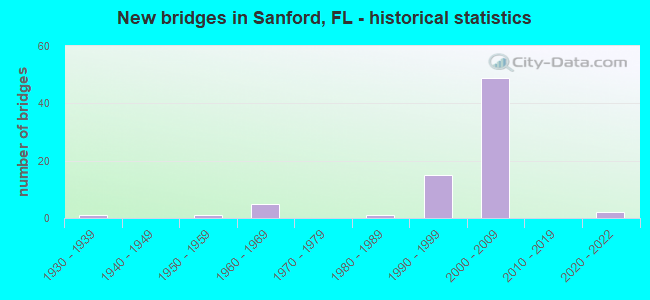
- New bridges - historical statistics
- 11930-1939
- 11950-1959
- 51960-1969
- 11980-1989
- 151990-1999
- 492000-2009
- 22020-2022

- Reconstructed bridges - Historical Statistics
- 41990-1999
- 12000-2009


- Bridge Condition - Deck
- 2.9%Excellent
- 2.9%Very good
- 91.2%Good
- 2.9%Satisfactory

- Bridge Condition - Superstructure
- 2.9%Excellent
- 26.5%Very good
- 70.6%Good

- Bridge Condition - Substructure
- 2.9%Excellent
- 17.6%Very good
- 73.5%Good
- 5.9%Satisfactory

- Bridge Condition - Channel
- 60.0%Good
- 20.0%Satisfactory
- 20.0%Fair

- Bridge Condition - Culverts
- 75.0%Good
- 25.0%Satisfactory
Find on map >> Show street view
Structure Number: 770002, Location: Seminole Blvd - Mills Cr (Lat: 28.816053, Lng: -81.277286), Route carried "on" structure: City street , Year Built: 1935, Status: Open, Structure Length: 1.95m (6.40ft), Average Daily Traffic: 14,000 (year 2021), Truck Traffic: 5%, Average Future Daily Traffic: 24,290 (year 2042), Design Load: H 15, Features Intersected: Mills Creek, Facility Carried by Structure: Seminole Blvd
Minimum Vertical Clearance: 30+ m (98+ ft), Kilometerpoint: 22.302, Lanes on structure: 2, Owner: City or Municipal Highway Agency, Approaching Roadway Width: 11.9m (39.0ft), Material/Design: Concrete, Design/Construction: Tee Beam, Number Of Spans In Main Unit: 2, Length of Maximum Span: 9.1m (29.9ft), Curb-To-Curb Width: 12.2m (40.0ft), Out-to-Out Width: 13.1m (43.0ft)
Condition: Deck: Good, Superstructure: Good, Substructure: Satisfactory, Channel: Good, Operating Rating: 63.3 metric tons, Method Used To Determine Operating Rating: Load Factor (LF), Inventory Rating: 37.9 metric tons, Method Used To Determine Inventory Rating: Load Factor (LF), Structural Evaluation: Equal to present minimum criteria, Deck Geometry: Somewhat better than minimum adequacy, Waterway Adequacy: Equal to present desirable criteria, Approach Roadway Alignment: Equal to present desirable criteria, Designated Inspection Frequency: Every 24 months, Underwater Inspection Frequency: Every 24 months, Inspection Date: August 2021, Underwater Inspection Date: August 2021, Deck Structure Type: Concrete Cast-file-Place, Wearing Surface/Protective System: Wearing Surface: Bituminous
Find on map >> Show street view
Structure Number: 770005, Location: SR-46 - Mills Creek (Lat: 28.811633, Lng: -81.280750), Route carried "on" structure: State highway 46, Year Built: 1962, Status: Open, Structure Length: 0.67m (2.20ft), Average Daily Traffic: 18,300 (year 2020), Truck Traffic: 13%, Average Future Daily Traffic: 31,750 (year 2042), Design Load: H 20, Features Intersected: Mills Creek
Minimum Vertical Clearance: 30+ m (98+ ft), Kilometerpoint: 13.612, Lanes on structure: 4, Owner: State Highway Agency, Approaching Roadway Width: 20.7m (67.9ft), Material/Design: Concrete, Design/Construction: Culvert, Number Of Spans In Main Unit: 3, Length of Maximum Span: 2.1m (6.9ft)
Condition: Channel: Fair, Culverts: Satisfactory, Operating Rating: 75.6 metric tons, Method Used To Determine Operating Rating: Load Factor (LF), Inventory Rating: 45.3 metric tons, Method Used To Determine Inventory Rating: Load Factor (LF), Structural Evaluation: Equal to present minimum criteria, Waterway Adequacy: Equal to present desirable criteria, Approach Roadway Alignment: Equal to present desirable criteria, Designated Inspection Frequency: Every 24 months, Inspection Date: January 2022
Find on map >> Show street view
Structure Number: 770008, Location: I-4 WB - Ramp A1 and C1 (Lat: 28.796158, Lng: -81.345742), Route carried "on" structure: Interstate 4, Year Built: 1963, Year Reconstructed: 2002, Status: Open, Structure Length: 4.51m (14.80ft), Average Daily Traffic: 38,500 (year 2020), Truck Traffic: 8%, Average Future Daily Traffic: 66,798 (year 2042), Design Load: HS 20, Features Intersected: SR-417
Minimum Vertical Clearance: 30+ m (98+ ft), Kilometerpoint: 18.025, Lanes on structure: 3, Lanes under structure: 2, Base Highway Network: Yes, Owner: State Highway Agency, Approaching Roadway Width: 17.0m (55.8ft), Skew: 2 degrees, Material/Design: Prestressed concrete, Design/Construction: Stringer/Multi-beam, Number Of Spans In Main Unit: 3, Length of Maximum Span: 16.2m (53.1ft), Curb-To-Curb Width: 17.1m (56.1ft), Out-to-Out Width: 17.8m (58.4ft)
Condition: Deck: Good, Superstructure: Good, Substructure: Good, Operating Rating: 57.6 metric tons, Method Used To Determine Operating Rating: Load Factor (LF), Inventory Rating: 34.6 metric tons, Method Used To Determine Inventory Rating: Load Factor (LF), Structural Evaluation: Better than present minimum criteria, Deck Geometry: Equal to present minimum criteria, Underclear: Equal to present minimum criteria, Approach Roadway Alignment: Equal to present desirable criteria, Designated Inspection Frequency: Every 24 months, Inspection Date: January 2021, Deck Structure Type: Concrete Cast-file-Place, Wearing Surface/Protective System: Wearing Surface: Monolithic Concrete
Find on map >> Show street view
Structure Number: 770029, Location: .7 Mi East of SR-46 (Lat: 28.819839, Lng: -81.333628), Route carried "on" structure: Interstate 400, Year Built: 1959, Year Reconstructed: 2004, Status: Open, Structure Length: 0.70m (2.30ft), Average Daily Traffic: 131,000 (year 2020), Truck Traffic: 8%, Average Future Daily Traffic: 227,285 (year 2042), Design Load: HS 20+Mod, Features Intersected: Outfall Ditch, Facility Carried by Structure: I-4
Minimum Vertical Clearance: 30+ m (98+ ft), Kilometerpoint: 20.923, Lanes on structure: 8, Base Highway Network: Yes, Owner: State Highway Agency, Approaching Roadway Width: 47.2m (154.9ft), Skew: 33 degrees, Material/Design: Concrete, Design/Construction: Culvert, Number Of Spans In Main Unit: 2, Length of Maximum Span: 3.0m (9.8ft)
Condition: Channel: Satisfactory, Culverts: Good, Operating Rating: 79.4 metric tons, Method Used To Determine Operating Rating: Load Factor (LF), Inventory Rating: 47.6 metric tons, Method Used To Determine Inventory Rating: Load Factor (LF), Structural Evaluation: Better than present minimum criteria, Waterway Adequacy: Equal to present desirable criteria, Approach Roadway Alignment: Equal to present desirable criteria, Designated Inspection Frequency: Every 24 months, Inspection Date: May 2020
Find on map >> Show street view
Structure Number: 770044, Location: 0.7 MI S OF CR 427 (Lat: 28.748131, Lng: -81.264439), Route carried "on" structure: State highway 417, Year Built: 1993, Status: Open, Structure Length: 4.19m (13.75ft), Average Daily Traffic: 27,400 (year 2020), Truck Traffic: 12%, Average Future Daily Traffic: 47,539 (year 2042), Design Load: HS 20+Mod, Features Intersected: SANFORD AVE
Minimum Vertical Clearance: 30+ m (98+ ft), Kilometerpoint: 17.168, Lanes on structure: 2, Lanes under structure: 2, Base Highway Network: Yes, Toll: On toll road, Owner: State Toll Authority, Approaching Roadway Width: 11.6m (38.1ft), Skew: 5 degrees, Material/Design: Prestressed concrete, Design/Construction: Stringer/Multi-beam, Number Of Spans In Main Unit: 1, Length of Maximum Span: 41.9m (137.5ft), Curb-To-Curb Width: 12.2m (40.0ft), Out-to-Out Width: 13.1m (43.0ft)
Condition: Deck: Good, Superstructure: Good, Substructure: Good, Operating Rating: 34.7 metric tons, Method Used To Determine Operating Rating: Load and Resistance Factor (LRFR), Inventory Rating: 26.9 metric tons, Method Used To Determine Inventory Rating: Load and Resistance Factor (LRFR), Structural Evaluation: Equal to present minimum criteria, Deck Geometry: Better than present minimum criteria, Underclear: Superior to present desirable criteria, Approach Roadway Alignment: Equal to present desirable criteria, Designated Inspection Frequency: Every 24 months, Inspection Date: January 2022, Deck Structure Type: Concrete Cast-file-Place
Find on map >> Show street view
Structure Number: 770045, Location: 0.2MI S OF LAKE MARY BLVD (Lat: 28.757025, Lng: -81.268903), Route carried "on" structure: State highway 417, Year Built: 1993, Status: Open, Structure Length: 4.82m (15.81ft), Average Daily Traffic: 27,400 (year 2020), Truck Traffic: 11%, Average Future Daily Traffic: 47,539 (year 2042), Design Load: HS 20, Features Intersected: CR 427
Minimum Vertical Clearance: 30+ m (98+ ft), Kilometerpoint: 18.250, Lanes on structure: 2, Lanes under structure: 6, Base Highway Network: Yes, Toll: On toll road, Owner: State Toll Authority, Approaching Roadway Width: 11.6m (38.1ft), Skew: 1 degrees, Material/Design: Steel, Design/Construction: Stringer/Multi-beam, Number Of Spans In Main Unit: 1, Length of Maximum Span: 48.2m (158.1ft), Curb-To-Curb Width: 12.2m (40.0ft), Out-to-Out Width: 13.1m (43.0ft)
Condition: Deck: Good, Superstructure: Good, Substructure: Good, Inventory Rating: 57.8 metric tons, Method Used To Determine Inventory Rating: Load Factor (LF), Structural Evaluation: Better than present minimum criteria, Deck Geometry: Better than present minimum criteria, Underclear: Superior to present desirable criteria, Approach Roadway Alignment: Equal to present desirable criteria, Designated Inspection Frequency: Every 24 months, Inspection Date: December 2021, Deck Structure Type: Concrete Cast-file-Place
Find on map >> Show street view
Structure Number: 770046, Location: 0.2MI S OF LAKE MARY BLVD (Lat: 28.757153, Lng: -81.268619), Route carried "on" structure: State highway 417, Year Built: 1993, Status: Open, Structure Length: 4.82m (15.81ft), Average Daily Traffic: 27,400 (year 2020), Truck Traffic: 12%, Average Future Daily Traffic: 47,539 (year 2042), Design Load: HS 20, Features Intersected: CR 427
Minimum Vertical Clearance: 30+ m (98+ ft), Kilometerpoint: 18.256, Lanes on structure: 2, Lanes under structure: 6, Base Highway Network: Yes, Toll: On toll road, Owner: State Toll Authority, Approaching Roadway Width: 11.1m (36.4ft), Skew: 1 degrees, Material/Design: Steel, Design/Construction: Stringer/Multi-beam, Number Of Spans In Main Unit: 1, Length of Maximum Span: 48.2m (158.1ft), Curb-To-Curb Width: 12.2m (40.0ft), Out-to-Out Width: 13.1m (43.0ft)
Condition: Deck: Good, Superstructure: Good, Substructure: Good, Inventory Rating: 57.8 metric tons, Method Used To Determine Inventory Rating: Load Factor (LF), Structural Evaluation: Better than present minimum criteria, Deck Geometry: Better than present minimum criteria, Underclear: Better than present minimum criteria, Approach Roadway Alignment: Equal to present desirable criteria, Designated Inspection Frequency: Every 24 months, Inspection Date: December 2021, Deck Structure Type: Concrete Cast-file-Place
Find on map >> Show street view
Structure Number: 770047, Location: 0.2 MI N OF CR 427 (Lat: 28.760069, Lng: -81.270142), Route carried "on" structure: State highway 417, Year Built: 1993, Status: Open, Structure Length: 4.74m (15.55ft), Average Daily Traffic: 27,400 (year 2020), Truck Traffic: 12%, Average Future Daily Traffic: 47,539 (year 2042), Design Load: HS 20, Features Intersected: LAKE MARY BLVD
Minimum Vertical Clearance: 30+ m (98+ ft), Kilometerpoint: 18.606, Lanes on structure: 2, Lanes under structure: 7, Base Highway Network: Yes, Toll: On toll road, Owner: State Toll Authority, Approaching Roadway Width: 11.6m (38.1ft), Skew: 1 degrees, Material/Design: Steel, Design/Construction: Stringer/Multi-beam, Number Of Spans In Main Unit: 1, Length of Maximum Span: 47.4m (155.5ft), Curb-To-Curb Width: 13.4m (44.0ft), Out-to-Out Width: 14.4m (47.2ft)
Condition: Deck: Good, Superstructure: Good, Substructure: Good, Inventory Rating: 59.2 metric tons, Method Used To Determine Inventory Rating: Load Factor (LF), Structural Evaluation: Better than present minimum criteria, Deck Geometry: Superior to present desirable criteria, Underclear: Equal to present minimum criteria, Approach Roadway Alignment: Equal to present desirable criteria, Designated Inspection Frequency: Every 24 months, Inspection Date: January 2022, Deck Structure Type: Concrete Cast-file-Place
Find on map >> Show street view
Structure Number: 770048, Location: 0.2 MI N OF CR 427 (Lat: 28.760089, Lng: -81.269839), Route carried "on" structure: State highway 417, Year Built: 1993, Status: Open, Structure Length: 4.74m (15.55ft), Average Daily Traffic: 27,400 (year 2020), Truck Traffic: 12%, Average Future Daily Traffic: 47,539 (year 2042), Design Load: HS 20, Features Intersected: LAKE MARY BLVD
Minimum Vertical Clearance: 30+ m (98+ ft), Kilometerpoint: 18.596, Lanes on structure: 2, Lanes under structure: 7, Base Highway Network: Yes, Toll: On toll road, Owner: State Toll Authority, Approaching Roadway Width: 11.6m (38.1ft), Skew: 1 degrees, Material/Design: Steel, Design/Construction: Stringer/Multi-beam, Number Of Spans In Main Unit: 1, Length of Maximum Span: 47.4m (155.5ft), Curb-To-Curb Width: 12.3m (40.4ft), Out-to-Out Width: 13.2m (43.3ft)
Condition: Deck: Good, Superstructure: Good, Substructure: Good, Inventory Rating: 61.5 metric tons, Method Used To Determine Inventory Rating: Load Factor (LF), Structural Evaluation: Better than present minimum criteria, Deck Geometry: Better than present minimum criteria, Underclear: Equal to present minimum criteria, Approach Roadway Alignment: Equal to present desirable criteria, Designated Inspection Frequency: Every 24 months, Inspection Date: January 2022, Deck Structure Type: Concrete Cast-file-Place
Find on map >> Show street view
Structure Number: 770069, Location: 0.9 MI N OF CR 427 (Lat: 28.769511, Lng: -81.274581), Route carried "on" structure: Ramp State highway 417, Year Built: 1993, Status: Open, Structure Length: 3.66m (12.01ft), Average Daily Traffic: 2,500 (year 2020), Truck Traffic: 12%, Average Future Daily Traffic: 4,338 (year 2042), Design Load: HS 20+Mod, Features Intersected: AIRPORT BLVD
Minimum Vertical Clearance: 30+ m (98+ ft), Kilometerpoint: 0.095, Lanes on structure: 2, Lanes under structure: 2, Toll: On toll road, Owner: State Toll Authority, Approaching Roadway Width: 12.2m (40.0ft), Material/Design: Prestressed concrete, Design/Construction: Stringer/Multi-beam, Number Of Spans In Main Unit: 2, Length of Maximum Span: 19.1m (62.7ft), Curb-To-Curb Width: 12.2m (40.0ft), Out-to-Out Width: 13.1m (43.0ft)
Condition: Deck: Good, Superstructure: Good, Substructure: Good, Operating Rating: 39.6 metric tons, Method Used To Determine Operating Rating: Load and Resistance Factor (LRFR), Inventory Rating: 30.5 metric tons, Method Used To Determine Inventory Rating: Load and Resistance Factor (LRFR), Structural Evaluation: Better than present minimum criteria, Deck Geometry: Superior to present desirable criteria, Underclear: Superior to present desirable criteria, Approach Roadway Alignment: Equal to present minimum criteria, Designated Inspection Frequency: Every 24 months, Inspection Date: December 2021, Deck Structure Type: Concrete Cast-file-Place
Find on map >> Show street view
Structure Number: 770078, Location: Ramp B1 - Eastbound C-D (Lat: 28.789578, Lng: -81.348197), Route carried "on" structure: Ramp Interstate 4, Year Built: 2002, Status: Open, Structure Length: 12.13m (39.80ft), Average Daily Traffic: 4,900 (year 2020), Truck Traffic: 4%, Average Future Daily Traffic: 8,502 (year 2042), Design Load: HS 20, Features Intersected: Eastbound C-D, Facility Carried by Structure: Ramp B1 EB
Minimum Vertical Clearance: 30+ m (98+ ft), Kilometerpoint: 0.298, Lanes on structure: 1, Lanes under structure: 2, Owner: State Highway Agency, Approaching Roadway Width: 7.9m (25.9ft), Material/Design: Steel continuous, Design/Construction: Stringer/Multi-beam, Number Of Spans In Main Unit: 3, Length of Maximum Span: 54.3m (178.1ft), Curb-To-Curb Width: 7.9m (25.9ft), Out-to-Out Width: 9.0m (29.5ft)
Condition: Deck: Good, Superstructure: Good, Substructure: Very good, Operating Rating: 55.5 metric tons, Method Used To Determine Operating Rating: Load Factor (LF), Inventory Rating: 32.7 metric tons, Method Used To Determine Inventory Rating: Load Factor (LF), Structural Evaluation: Better than present minimum criteria, Deck Geometry: Equal to present desirable criteria, Underclear: Equal to present desirable criteria, Approach Roadway Alignment: Equal to present desirable criteria, Designated Inspection Frequency: Every 24 months, Inspection Date: June 2020, Deck Structure Type: Concrete Cast-file-Place, Wearing Surface/Protective System: Wearing Surface: Monolithic Concrete
Find on map >> Show street view
Structure Number: 77008, Location: EB C-D - Ramp A1 and C1 (Lat: 28.796303, Lng: -81.344739), Route carried "on" structure: Ramp Interstate 4, Year Built: 2002, Status: Open, Structure Length: 4.74m (15.55ft), Average Daily Traffic: 14,500 (year 2020), Truck Traffic: 4%, Average Future Daily Traffic: 25,158 (year 2042), Design Load: HS 20, Features Intersected: SR-417
Minimum Vertical Clearance: 30+ m (98+ ft), Kilometerpoint: 1.040, Lanes on structure: 2, Lanes under structure: 2, Owner: State Highway Agency, Approaching Roadway Width: 11.0m (36.1ft), Skew: 3 degrees, Material/Design: Prestressed concrete, Design/Construction: Stringer/Multi-beam, Number Of Spans In Main Unit: 2, Length of Maximum Span: 24.2m (79.4ft), Curb-To-Curb Width: 11.9m (39.0ft), Out-to-Out Width: 13.0m (42.7ft)
Condition: Deck: Good, Superstructure: Good, Substructure: Good, Operating Rating: 73.4 metric tons, Method Used To Determine Operating Rating: Load Factor (LF), Inventory Rating: 44.0 metric tons, Method Used To Determine Inventory Rating: Load Factor (LF), Structural Evaluation: Better than present minimum criteria, Deck Geometry: Superior to present desirable criteria, Underclear: Better than present minimum criteria, Approach Roadway Alignment: Equal to present desirable criteria, Designated Inspection Frequency: Every 24 months, Inspection Date: August 2020, Deck Structure Type: Concrete Cast-file-Place, Wearing Surface/Protective System: Wearing Surface: Monolithic Concrete
Find on map >> Show street view
Structure Number: 770081, Location: EB C-D - Ramp C2 (Lat: 28.798794, Lng: -81.343175), Route carried "on" structure: State highway 4, Year Built: 2002, Status: Open, Structure Length: 6.00m (19.69ft), Average Daily Traffic: 9,600 (year 2020), Truck Traffic: 4%, Average Future Daily Traffic: 16,656 (year 2042), Design Load: HS 20, Features Intersected: SR-417
Minimum Vertical Clearance: 30+ m (98+ ft), Kilometerpoint: 1.352, Lanes on structure: 2, Lanes under structure: 2, Owner: State Highway Agency, Approaching Roadway Width: 12.0m (39.4ft), Skew: 4 degrees, Material/Design: Steel, Design/Construction: Stringer/Multi-beam, Number Of Spans In Main Unit: 1, Length of Maximum Span: 59.4m (194.9ft), Curb-To-Curb Width: 12.0m (39.4ft), Out-to-Out Width: 13.0m (42.7ft)
Condition: Deck: Good, Superstructure: Very good, Substructure: Good, Operating Rating: 54.6 metric tons, Method Used To Determine Operating Rating: Load Factor (LF), Inventory Rating: 32.7 metric tons, Method Used To Determine Inventory Rating: Load Factor (LF), Structural Evaluation: Better than present minimum criteria, Deck Geometry: Equal to present minimum criteria, Underclear: Better than present minimum criteria, Approach Roadway Alignment: Equal to present desirable criteria, Designated Inspection Frequency: Every 24 months, Inspection Date: August 2020, Deck Structure Type: Concrete Cast-file-Place, Wearing Surface/Protective System: Wearing Surface: Monolithic Concrete
Find on map >> Show street view
Structure Number: 770084, Location: I-4-WB over SR-46 (Lat: 28.811297, Lng: -81.338142), Route carried "on" structure: State highway 4, Year Built: 2004, Year Reconstructed: 2013, Status: Open, Structure Length: 6.17m (20.24ft), Average Daily Traffic: 38,500 (year 2020), Truck Traffic: 8%, Average Future Daily Traffic: 66,798 (year 2042), Design Load: HL 93, Features Intersected: SR-46
Minimum Vertical Clearance: 30+ m (98+ ft), Kilometerpoint: 19.853, Lanes on structure: 5, Lanes under structure: 8, Base Highway Network: Yes, Owner: State Highway Agency, Approaching Roadway Width: 21.0m (68.9ft), Skew: 32 degrees, Material/Design: Steel, Design/Construction: Stringer/Multi-beam, Number Of Spans In Main Unit: 1, Length of Maximum Span: 61.1m (200.5ft), Curb-To-Curb Width: 21.0m (68.9ft), Out-to-Out Width: 42.1m (138.1ft)
Condition: Deck: Good, Superstructure: Good, Substructure: Good, Operating Rating: 55.5 metric tons, Method Used To Determine Operating Rating: Load and Resistance Factor (LRFR), Inventory Rating: 42.8 metric tons, Method Used To Determine Inventory Rating: Load and Resistance Factor (LRFR), Structural Evaluation: Better than present minimum criteria, Deck Geometry: Meets minimum limits, Underclear: Superior to present desirable criteria, Approach Roadway Alignment: Equal to present desirable criteria, Designated Inspection Frequency: Every 24 months, Inspection Date: October 2021, Deck Structure Type: Concrete Cast-file-Place, Wearing Surface/Protective System: Wearing Surface: Monolithic Concrete
Find on map >> Show street view
Structure Number: 770085, Location: I-4 EB over SR-46 (Lat: 28.811289, Lng: -81.337619), Route carried "on" structure: Interstate 4, Year Built: 2003, Status: Open, Structure Length: 6.16m (20.21ft), Average Daily Traffic: 38,500 (year 2020), Truck Traffic: 8%, Average Future Daily Traffic: 66,798 (year 2042), Design Load: HS 20, Features Intersected: SR-46
Minimum Vertical Clearance: 30+ m (98+ ft), Kilometerpoint: 19.853, Lanes on structure: 4, Lanes under structure: 8, Base Highway Network: Yes, Owner: State Highway Agency, Approaching Roadway Width: 21.0m (68.9ft), Skew: 2 degrees, Material/Design: Steel, Design/Construction: Stringer/Multi-beam, Number Of Spans In Main Unit: 1, Length of Maximum Span: 61.1m (200.5ft), Curb-To-Curb Width: 21.0m (68.9ft), Out-to-Out Width: 22.9m (75.1ft)
Condition: Deck: Good, Superstructure: Good, Substructure: Good, Operating Rating: 72.4 metric tons, Method Used To Determine Operating Rating: Load Factor (LF), Inventory Rating: 43.5 metric tons, Method Used To Determine Inventory Rating: Load Factor (LF), Structural Evaluation: Better than present minimum criteria, Deck Geometry: Better than present minimum criteria, Underclear: Superior to present desirable criteria, Approach Roadway Alignment: Equal to present desirable criteria, Designated Inspection Frequency: Every 24 months, Inspection Date: October 2021, Deck Structure Type: Concrete Cast-file-Place, Wearing Surface/Protective System: Wearing Surface: Monolithic Concrete
Find on map >> Show street view
Structure Number: 770086, Location: I-4WB-Orange Blvd & CSXRR (Lat: 28.829983, Lng: -81.325147), Route carried "on" structure: Interstate 4, Year Built: 2003, Status: Open, Structure Length: 8.60m (28.22ft), Average Daily Traffic: 65,500 (year 2020), Truck Traffic: 8%, Average Future Daily Traffic: 113,642 (year 2042), Design Load: HS 20, Features Intersected: Orange Blvd & CSXRR
Minimum Vertical Clearance: 30+ m (98+ ft), Kilometerpoint: 22.272, Lanes on structure: 3, Lanes under structure: 2, Base Highway Network: Yes, Owner: State Highway Agency, Approaching Roadway Width: 18.9m (62.0ft), Material/Design: Steel continuous, Design/Construction: Stringer/Multi-beam, Number Of Spans In Main Unit: 2, Length of Maximum Span: 42.7m (140.1ft), Curb-To-Curb Width: 19.5m (64.0ft), Out-to-Out Width: 20.4m (66.9ft)
Condition: Deck: Good, Superstructure: Good, Substructure: Good, Operating Rating: 50.3 metric tons, Method Used To Determine Operating Rating: Load Factor (LF), Inventory Rating: 30.1 metric tons, Method Used To Determine Inventory Rating: Load Factor (LF), Structural Evaluation: Better than present minimum criteria, Deck Geometry: Superior to present desirable criteria, Underclear: Superior to present desirable criteria, Approach Roadway Alignment: Equal to present desirable criteria, Designated Inspection Frequency: Every 24 months, Inspection Date: April 2021, Deck Structure Type: Concrete Cast-file-Place, Wearing Surface/Protective System: Wearing Surface: Monolithic Concrete
Find on map >> Show street view
Structure Number: 770087, Location: I-4EB - Orange Blvd & RR (Lat: 28.829650, Lng: -81.324647), Route carried "on" structure: Interstate 400, Year Built: 2003, Status: Open, Structure Length: 7.60m (24.93ft), Average Daily Traffic: 65,500 (year 2020), Truck Traffic: 8%, Average Future Daily Traffic: 113,642 (year 2042), Design Load: HS 20, Features Intersected: Orange Blvd.& CSX RR., Facility Carried by Structure: I-4 EB
Minimum Vertical Clearance: 30+ m (98+ ft), Kilometerpoint: 22.272, Lanes on structure: 3, Lanes under structure: 2, Base Highway Network: Yes, Owner: State Highway Agency, Approaching Roadway Width: 17.1m (56.1ft), Material/Design: Steel continuous, Design/Construction: Stringer/Multi-beam, Number Of Spans In Main Unit: 2, Length of Maximum Span: 37.7m (123.7ft), Curb-To-Curb Width: 17.7m (58.1ft), Out-to-Out Width: 20.2m (66.3ft)
Condition: Deck: Good, Superstructure: Good, Substructure: Good, Operating Rating: 58.2 metric tons, Method Used To Determine Operating Rating: Load Factor (LF), Inventory Rating: 34.9 metric tons, Method Used To Determine Inventory Rating: Load Factor (LF), Structural Evaluation: Better than present minimum criteria, Deck Geometry: Better than present minimum criteria, Underclear: Superior to present desirable criteria, Approach Roadway Alignment: Equal to present desirable criteria, Designated Inspection Frequency: Every 24 months, Inspection Date: April 2021, Deck Structure Type: Concrete Cast-file-Place, Wearing Surface/Protective System: Wearing Surface: Monolithic Concrete
Find on map >> Show street view
Structure Number: 770088, Location: Ramp D1-Orange Blvd&CSXRR (Lat: 28.830089, Lng: -81.325386), Route carried "on" structure: Ramp Other road 4, Year Built: 2004, Status: Open, Structure Length: 10.15m (33.30ft), Average Daily Traffic: 8,400 (year 2020), Truck Traffic: 8%, Average Future Daily Traffic: 14,574 (year 2042), Design Load: HS 20+Mod, Features Intersected: Orange Blvd & CSXRR, Facility Carried by Structure: Ramp D1
Minimum Vertical Clearance: 30+ m (98+ ft), Kilometerpoint: 0.402, Lanes on structure: 1, Lanes under structure: 2, Owner: State Highway Agency, Approaching Roadway Width: 9.4m (30.8ft), Material/Design: Prestressed concrete, Design/Construction: Stringer/Multi-beam, Number Of Spans In Main Unit: 3, Length of Maximum Span: 37.5m (123.0ft), Curb-To-Curb Width: 9.4m (30.8ft), Out-to-Out Width: 10.4m (34.1ft)
Condition: Deck: Good, Superstructure: Good, Substructure: Good, Operating Rating: 75.2 metric tons, Method Used To Determine Operating Rating: Load Factor (LF), Inventory Rating: 45.1 metric tons, Method Used To Determine Inventory Rating: Load Factor (LF), Structural Evaluation: Better than present minimum criteria, Deck Geometry: Superior to present desirable criteria, Underclear: Superior to present desirable criteria, Approach Roadway Alignment: Equal to present desirable criteria, Designated Inspection Frequency: Every 24 months, Inspection Date: August 2020, Deck Structure Type: Concrete Cast-file-Place, Wearing Surface/Protective System: Wearing Surface: Monolithic Concrete
Find on map >> Show street view
Structure Number: 770135, Location: I-4 EB Exit Ramp-Ramp L1 (Lat: 28.790833, Lng: -81.347222), Route carried "on" structure: Interstate 4, Year Built: 2021, Status: Open, Structure Length: 10.88m (35.70ft), Average Daily Traffic: 10,000 (year 2021), Truck Traffic: 14%, Average Future Daily Traffic: 17,000 (year 2042), Design Load: HL 93, Features Intersected: Ramp O1, Facility Carried by Structure: Ramp L1
Minimum Vertical Clearance: 30+ m (98+ ft), Kilometerpoint: 1.860, Lanes on structure: 3, Lanes under structure: 1, Base Highway Network: Yes, Toll: On toll road, Owner: State Highway Agency, Approaching Roadway Width: 17.1m (56.1ft), Skew: 3 degrees, Material/Design: Prestressed concrete, Design/Construction: Stringer/Multi-beam, Number Of Spans In Main Unit: 2, Length of Maximum Span: 54.8m (179.8ft), Curb-To-Curb Width: 21.6m (70.9ft), Out-to-Out Width: 22.3m (73.2ft)
Condition: Deck: Excellent, Superstructure: Excellent, Substructure: Excellent, Operating Rating: 56.5 metric tons, Method Used To Determine Operating Rating: Load and Resistance Factor (LRFR), Inventory Rating: 33.7 metric tons, Method Used To Determine Inventory Rating: Load and Resistance Factor (LRFR), Structural Evaluation: Superior to present desirable criteria, Deck Geometry: Superior to present desirable criteria, Underclear: Equal to present desirable criteria, Approach Roadway Alignment: Equal to present desirable criteria, Designated Inspection Frequency: Every 24 months, Inspection Date: October 2021, Deck Structure Type: Concrete Cast-file-Place, Wearing Surface/Protective System: Wearing Surface: Monolithic Concrete
Find on map >> Show street view
Structure Number: 7706, Location: 0.3 MI SOUTH OF US 17 92 (Lat: 28.769381, Lng: -81.275492), Route carried "on" structure: State highway 417, Year Built: 2002, Status: Open, Structure Length: 5.42m (17.78ft), Average Daily Traffic: 23,050 (year 2020), Truck Traffic: 12%, Average Future Daily Traffic: 39,992 (year 2042), Design Load: HS 20+Mod, Features Intersected: AIRPORT BLVD
Minimum Vertical Clearance: 30+ m (98+ ft), Kilometerpoint: 19.792, Lanes on structure: 2, Lanes under structure: 3, Base Highway Network: Yes, Toll: On toll road, Owner: State Toll Authority, Approaching Roadway Width: 12.2m (40.0ft), Skew: 4 degrees, Material/Design: Prestressed concrete, Design/Construction: Stringer/Multi-beam, Number Of Spans In Main Unit: 2, Length of Maximum Span: 30.7m (100.7ft), Curb-To-Curb Width: 12.2m (40.0ft), Out-to-Out Width: 13.1m (43.0ft)
Condition: Deck: Good, Superstructure: Very good, Substructure: Very good, Operating Rating: 67.7 metric tons, Method Used To Determine Operating Rating: Load Factor (LF), Inventory Rating: 42.5 metric tons, Method Used To Determine Inventory Rating: Load Factor (LF), Structural Evaluation: Equal to present desirable criteria, Deck Geometry: Better than present minimum criteria, Underclear: Superior to present desirable criteria, Approach Roadway Alignment: Better than present minimum criteria, Designated Inspection Frequency: Every 24 months, Inspection Date: Febuary 2022, Deck Structure Type: Concrete Cast-file-Place
Find on map >> Show street view
Structure Number: 770601, Location: 0.9MI NORTH OF CR 427 (Lat: 28.769408, Lng: -81.275119), Route carried "on" structure: State highway 417, Year Built: 2002, Status: Open, Structure Length: 5.09m (16.70ft), Average Daily Traffic: 23,050 (year 2020), Truck Traffic: 12%, Average Future Daily Traffic: 39,992 (year 2042), Design Load: HS 20+Mod, Features Intersected: AIRPORT BLVD
Minimum Vertical Clearance: 30+ m (98+ ft), Kilometerpoint: 19.766, Lanes on structure: 2, Lanes under structure: 3, Base Highway Network: Yes, Toll: On toll road, Owner: State Toll Authority, Approaching Roadway Width: 13.4m (44.0ft), Skew: 4 degrees, Material/Design: Prestressed concrete, Design/Construction: Stringer/Multi-beam, Number Of Spans In Main Unit: 2, Length of Maximum Span: 27.8m (91.2ft), Curb-To-Curb Width: 13.4m (44.0ft), Out-to-Out Width: 14.4m (47.2ft)
Condition: Deck: Good, Superstructure: Very good, Substructure: Very good, Operating Rating: 61.5 metric tons, Method Used To Determine Operating Rating: Load Factor (LF), Inventory Rating: 38.6 metric tons, Method Used To Determine Inventory Rating: Load Factor (LF), Structural Evaluation: Equal to present desirable criteria, Deck Geometry: Superior to present desirable criteria, Underclear: Superior to present desirable criteria, Approach Roadway Alignment: Better than present minimum criteria, Designated Inspection Frequency: Every 24 months, Inspection Date: Febuary 2022, Deck Structure Type: Concrete Cast-file-Place
Find on map >> Show street view
Structure Number: 770602, Location: 1.2 MI NORTH OF CR 427 (Lat: 28.771075, Lng: -81.279908), Route carried "on" structure: State highway 417, Year Built: 2002, Status: Open, Structure Length: 4.70m (15.42ft), Average Daily Traffic: 23,050 (year 2020), Truck Traffic: 12%, Average Future Daily Traffic: 39,992 (year 2042), Design Load: HS 20+Mod, Features Intersected: US 17 92
Minimum Vertical Clearance: 30+ m (98+ ft), Kilometerpoint: 20.281, Lanes on structure: 3, Lanes under structure: 4, Base Highway Network: Yes, Toll: On toll road, Owner: State Toll Authority, Approaching Roadway Width: 14.8m (48.6ft), Skew: 1 degrees, Material/Design: Steel, Design/Construction: Stringer/Multi-beam, Number Of Spans In Main Unit: 1, Length of Maximum Span: 47.0m (154.2ft), Curb-To-Curb Width: 15.9m (52.2ft), Out-to-Out Width: 16.8m (55.1ft)
Condition: Deck: Good, Superstructure: Very good, Substructure: Good, Operating Rating: 84.5 metric tons, Method Used To Determine Operating Rating: Load Factor (LF), Inventory Rating: 51.0 metric tons, Method Used To Determine Inventory Rating: Load Factor (LF), Structural Evaluation: Better than present minimum criteria, Deck Geometry: Somewhat better than minimum adequacy, Underclear: Better than present minimum criteria, Approach Roadway Alignment: Equal to present desirable criteria, Designated Inspection Frequency: Every 24 months, Inspection Date: Febuary 2022, Deck Structure Type: Concrete Cast-file-Place
Find on map >> Show street view
Structure Number: 770604, Location: 1.3 MI NORTH OF CR 427 (Lat: 28.771528, Lng: -81.283597), Route carried "on" structure: State highway 417, Year Built: 2002, Status: Open, Structure Length: 5.47m (17.95ft), Average Daily Traffic: 22,875 (year 2020), Truck Traffic: 12%, Average Future Daily Traffic: 39,688 (year 2042), Design Load: HS 20+Mod, Features Intersected: AIRPORT BLVD
Minimum Vertical Clearance: 30.45m (99.90ft), Kilometerpoint: 20.653, Lanes on structure: 2, Lanes under structure: 4, Base Highway Network: Yes, Toll: On toll road, Owner: State Toll Authority, Approaching Roadway Width: 10.7m (35.1ft), Skew: 4 degrees, Material/Design: Steel, Design/Construction: Stringer/Multi-beam, Number Of Spans In Main Unit: 1, Length of Maximum Span: 54.7m (179.5ft), Curb-To-Curb Width: 12.2m (40.0ft), Out-to-Out Width: 13.1m (43.0ft)
Condition: Deck: Good, Superstructure: Very good, Substructure: Good, Operating Rating: 74.8 metric tons, Method Used To Determine Operating Rating: Load Factor (LF), Inventory Rating: 45.1 metric tons, Method Used To Determine Inventory Rating: Load Factor (LF), Structural Evaluation: Better than present minimum criteria, Deck Geometry: Better than present minimum criteria, Underclear: Equal to present minimum criteria, Approach Roadway Alignment: Equal to present desirable criteria, Designated Inspection Frequency: Every 24 months, Inspection Date: January 2022, Deck Structure Type: Concrete Cast-file-Place
Find on map >> Show street view
Structure Number: 770605, Location: 1.2 MI NORTH OF CR 427 (Lat: 28.771819, Lng: -81.283900), Route carried "on" structure: State highway 417, Year Built: 2002, Status: Open, Structure Length: 6.33m (20.77ft), Average Daily Traffic: 22,875 (year 2020), Truck Traffic: 12%, Average Future Daily Traffic: 39,688 (year 2042), Design Load: HS 20+Mod, Features Intersected: AIRPORT BLVD
Minimum Vertical Clearance: 30.45m (99.90ft), Kilometerpoint: 20.674, Lanes on structure: 2, Lanes under structure: 4, Base Highway Network: Yes, Toll: On toll road, Owner: State Toll Authority, Approaching Roadway Width: 11.1m (36.4ft), Skew: 4 degrees, Material/Design: Steel, Design/Construction: Stringer/Multi-beam, Number Of Spans In Main Unit: 1, Length of Maximum Span: 63.3m (207.7ft), Curb-To-Curb Width: 12.2m (40.0ft), Out-to-Out Width: 13.1m (43.0ft)
Condition: Deck: Good, Superstructure: Good, Substructure: Good, Inventory Rating: 55.2 metric tons, Method Used To Determine Inventory Rating: Load Factor (LF), Structural Evaluation: Better than present minimum criteria, Deck Geometry: Better than present minimum criteria, Underclear: Equal to present minimum criteria, Approach Roadway Alignment: Equal to present desirable criteria, Designated Inspection Frequency: Every 24 months, Inspection Date: January 2022, Deck Structure Type: Concrete Cast-file-Place
Find on map >> Show street view
Structure Number: 770607, Location: 1.9 MI NORTH OF CR 427 (Lat: 28.774633, Lng: -81.293244), Route carried "on" structure: State highway 417, Year Built: 2002, Status: Open, Structure Length: 2.40m (7.87ft), Average Daily Traffic: 22,875 (year 2020), Truck Traffic: 12%, Average Future Daily Traffic: 39,688 (year 2042), Design Load: HS 20+Mod, Features Intersected: LIVE OAK BLVD
Minimum Vertical Clearance: 30.45m (99.90ft), Kilometerpoint: 21.678, Lanes on structure: 2, Lanes under structure: 2, Base Highway Network: Yes, Toll: On toll road, Owner: State Toll Authority, Approaching Roadway Width: 11.1m (36.4ft), Skew: 1 degrees, Material/Design: Prestressed concrete, Design/Construction: Stringer/Multi-beam, Number Of Spans In Main Unit: 1, Length of Maximum Span: 24.0m (78.7ft), Curb-To-Curb Width: 12.2m (40.0ft), Out-to-Out Width: 13.1m (43.0ft)
Condition: Deck: Good, Superstructure: Good, Substructure: Good, Operating Rating: 54.9 metric tons, Method Used To Determine Operating Rating: Load Factor (LF), Inventory Rating: 32.9 metric tons, Method Used To Determine Inventory Rating: Load Factor (LF), Structural Evaluation: Better than present minimum criteria, Deck Geometry: Better than present minimum criteria, Underclear: Superior to present desirable criteria, Approach Roadway Alignment: Better than present minimum criteria, Designated Inspection Frequency: Every 24 months, Inspection Date: January 2022, Deck Structure Type: Concrete Cast-file-Place
Find on map >> Show street view
Structure Number: 770608, Location: 2.3 MI NORTH OF CR 427 (Lat: 28.778506, Lng: -81.298247), Route carried "on" structure: State highway 417, Year Built: 2002, Status: Open, Structure Length: 44.97m (147.54ft), Average Daily Traffic: 22,875 (year 2020), Truck Traffic: 12%, Average Future Daily Traffic: 39,688 (year 2042), Design Load: HS 20+Mod, Features Intersected: CSX RR & OLD LK MARY BLV
Minimum Vertical Clearance: 30+ m (98+ ft), Kilometerpoint: 21.937, Lanes on structure: 2, Lanes under structure: 3, Base Highway Network: Yes, Toll: On toll road, Owner: State Toll Authority, Approaching Roadway Width: 11.0m (36.1ft), Material/Design: Prestressed concrete, Design/Construction: Stringer/Multi-beam, Number Of Spans In Main Unit: 12, Length of Maximum Span: 38.7m (127.0ft), Curb-To-Curb Width: 12.2m (40.0ft), Out-to-Out Width: 13.1m (43.0ft)
Condition: Deck: Good, Superstructure: Good, Substructure: Good, Operating Rating: 57.3 metric tons, Method Used To Determine Operating Rating: Load Factor (LF), Inventory Rating: 34.4 metric tons, Method Used To Determine Inventory Rating: Load Factor (LF), Structural Evaluation: Better than present minimum criteria, Deck Geometry: Better than present minimum criteria, Underclear: Superior to present desirable criteria, Approach Roadway Alignment: Equal to present desirable criteria, Designated Inspection Frequency: Every 24 months, Inspection Date: January 2022, Deck Structure Type: Concrete Cast-file-Place
Find on map >> Show street view
Structure Number: 770609, Location: 2.3 MI NORTH OF CR 427 (Lat: 28.778711, Lng: -81.298089), Route carried "on" structure: State highway 417, Year Built: 2002, Status: Open, Structure Length: 44.39m (145.64ft), Average Daily Traffic: 22,875 (year 2020), Truck Traffic: 12%, Average Future Daily Traffic: 39,688 (year 2042), Design Load: HS 20+Mod, Features Intersected: CSX RR & OLD LK MARY BLV
Minimum Vertical Clearance: 30+ m (98+ ft), Kilometerpoint: 21.937, Lanes on structure: 2, Lanes under structure: 3, Base Highway Network: Yes, Toll: On toll road, Owner: State Toll Authority, Approaching Roadway Width: 11.0m (36.1ft), Material/Design: Prestressed concrete, Design/Construction: Stringer/Multi-beam, Number Of Spans In Main Unit: 12, Length of Maximum Span: 38.1m (125.0ft), Curb-To-Curb Width: 12.2m (40.0ft), Out-to-Out Width: 13.1m (43.0ft)
Condition: Deck: Good, Superstructure: Good, Substructure: Good, Operating Rating: 55.7 metric tons, Method Used To Determine Operating Rating: Load Factor (LF), Inventory Rating: 33.5 metric tons, Method Used To Determine Inventory Rating: Load Factor (LF), Structural Evaluation: Better than present minimum criteria, Deck Geometry: Better than present minimum criteria, Underclear: Superior to present desirable criteria, Approach Roadway Alignment: Equal to present desirable criteria, Designated Inspection Frequency: Every 24 months, Inspection Date: January 2022, Deck Structure Type: Concrete Cast-file-Place
Find on map >> Show street view
Structure Number: 77061, Location: 1.7 MI N OF US 17 92 (Lat: 28.786467, Lng: -81.301639), Route carried "on" structure: State highway 417, Year Built: 2001, Status: Open, Structure Length: 3.82m (12.53ft), Average Daily Traffic: 22,875 (year 2020), Truck Traffic: 12%, Average Future Daily Traffic: 39,688 (year 2042), Design Load: HS 20+Mod, Features Intersected: CR 46A
Minimum Vertical Clearance: 30.45m (99.90ft), Kilometerpoint: 23.260, Lanes on structure: 2, Lanes under structure: 6, Base Highway Network: Yes, Toll: On toll road, Owner: State Toll Authority, Approaching Roadway Width: 12.2m (40.0ft), Material/Design: Prestressed concrete, Design/Construction: Stringer/Multi-beam, Number Of Spans In Main Unit: 1, Length of Maximum Span: 38.2m (125.3ft), Curb-To-Curb Width: 12.2m (40.0ft), Out-to-Out Width: 13.1m (43.0ft)
Condition: Deck: Good, Superstructure: Good, Substructure: Satisfactory, Operating Rating: 49.7 metric tons, Method Used To Determine Operating Rating: Load and Resistance Factor (LRFR), Inventory Rating: 43.2 metric tons, Method Used To Determine Inventory Rating: Load and Resistance Factor (LRFR), Structural Evaluation: Equal to present minimum criteria, Deck Geometry: Better than present minimum criteria, Underclear: Equal to present minimum criteria, Approach Roadway Alignment: Equal to present desirable criteria, Designated Inspection Frequency: Every 24 months, Inspection Date: January 2022, Deck Structure Type: Concrete Cast-file-Place
Find on map >> Show street view
Structure Number: 770611, Location: 1.7 MI N OF US 17 92 (Lat: 28.786461, Lng: -81.301356), Route carried "on" structure: State highway 417, Year Built: 2001, Status: Open, Structure Length: 3.83m (12.57ft), Average Daily Traffic: 22,875 (year 2020), Truck Traffic: 12%, Average Future Daily Traffic: 39,688 (year 2042), Design Load: HS 20+Mod, Features Intersected: CR 46A
Minimum Vertical Clearance: 30.45m (99.90ft), Kilometerpoint: 23.255, Lanes on structure: 2, Lanes under structure: 5, Base Highway Network: Yes, Toll: On toll road, Owner: State Toll Authority, Approaching Roadway Width: 12.2m (40.0ft), Material/Design: Prestressed concrete, Design/Construction: Stringer/Multi-beam, Number Of Spans In Main Unit: 1, Length of Maximum Span: 38.3m (125.7ft), Curb-To-Curb Width: 12.2m (40.0ft), Out-to-Out Width: 13.1m (43.0ft)
Condition: Deck: Good, Superstructure: Good, Substructure: Good, Operating Rating: 49.7 metric tons, Method Used To Determine Operating Rating: Load and Resistance Factor (LRFR), Inventory Rating: 43.2 metric tons, Method Used To Determine Inventory Rating: Load and Resistance Factor (LRFR), Structural Evaluation: Better than present minimum criteria, Deck Geometry: Better than present minimum criteria, Underclear: Equal to present minimum criteria, Approach Roadway Alignment: Equal to present desirable criteria, Designated Inspection Frequency: Every 24 months, Inspection Date: January 2022, Deck Structure Type: Concrete Cast-file-Place
Find on map >> Show street view
Structure Number: 770612, Location: 3.5 MI N OF US 17 92 (Lat: 28.799492, Lng: -81.316508), Route carried "on" structure: State highway 417, Year Built: 2001, Status: Open, Structure Length: 3.57m (11.71ft), Average Daily Traffic: 21,700 (year 2020), Truck Traffic: 12%, Average Future Daily Traffic: 37,650 (year 2042), Design Load: HS 20+Mod, Features Intersected: UPSALA RD CR 15
Minimum Vertical Clearance: 30+ m (98+ ft), Kilometerpoint: 25.841, Lanes on structure: 2, Lanes under structure: 3, Base Highway Network: Yes, Toll: On toll road, Owner: State Toll Authority, Approaching Roadway Width: 11.0m (36.1ft), Skew: 1 degrees, Material/Design: Prestressed concrete, Design/Construction: Stringer/Multi-beam, Number Of Spans In Main Unit: 1, Length of Maximum Span: 35.7m (117.1ft), Curb-To-Curb Width: 12.2m (40.0ft), Out-to-Out Width: 13.1m (43.0ft)
Condition: Deck: Good, Superstructure: Very good, Substructure: Good, Operating Rating: 45.9 metric tons, Method Used To Determine Operating Rating: Load and Resistance Factor (LRFR), Inventory Rating: 42.0 metric tons, Method Used To Determine Inventory Rating: Load and Resistance Factor (LRFR), Structural Evaluation: Better than present minimum criteria, Deck Geometry: Better than present minimum criteria, Underclear: Superior to present desirable criteria, Approach Roadway Alignment: Equal to present desirable criteria, Designated Inspection Frequency: Every 24 months, Inspection Date: January 2022, Deck Structure Type: Concrete Cast-file-Place
Find on map >> Show street view
Structure Number: 770613, Location: 3.5 MI N OF US 17 92 (Lat: 28.799739, Lng: -81.316475), Route carried "on" structure: State highway 417, Year Built: 2001, Status: Open, Structure Length: 3.57m (11.71ft), Average Daily Traffic: 21,700 (year 2020), Truck Traffic: 12%, Average Future Daily Traffic: 37,650 (year 2042), Design Load: HS 20+Mod, Features Intersected: UPSALA RD CR 15
Minimum Vertical Clearance: 30+ m (98+ ft), Kilometerpoint: 25.835, Lanes on structure: 2, Lanes under structure: 3, Base Highway Network: Yes, Toll: On toll road, Owner: State Toll Authority, Approaching Roadway Width: 11.0m (36.1ft), Skew: 1 degrees, Material/Design: Prestressed concrete, Design/Construction: Stringer/Multi-beam, Number Of Spans In Main Unit: 1, Length of Maximum Span: 35.7m (117.1ft), Curb-To-Curb Width: 12.2m (40.0ft), Out-to-Out Width: 13.1m (43.0ft)
Condition: Deck: Good, Superstructure: Very good, Substructure: Very good, Operating Rating: 45.9 metric tons, Method Used To Determine Operating Rating: Load and Resistance Factor (LRFR), Inventory Rating: 42.0 metric tons, Method Used To Determine Inventory Rating: Load and Resistance Factor (LRFR), Structural Evaluation: Equal to present desirable criteria, Deck Geometry: Better than present minimum criteria, Underclear: Superior to present desirable criteria, Approach Roadway Alignment: Equal to present desirable criteria, Designated Inspection Frequency: Every 24 months, Inspection Date: January 2022, Deck Structure Type: Concrete Cast-file-Place
Find on map >> Show street view
Structure Number: 770614, Location: 0.9 MI EAST OF I-4 (Lat: 28.797744, Lng: -81.332025), Route carried "on" structure: State highway 417, Year Built: 2002, Status: Open, Structure Length: 7.54m (24.74ft), Average Daily Traffic: 21,700 (year 2020), Truck Traffic: 12%, Average Future Daily Traffic: 37,650 (year 2042), Design Load: HS 20, Features Intersected: SR 341B (RINEHART RD)
Minimum Vertical Clearance: 30+ m (98+ ft), Kilometerpoint: 27.356, Lanes on structure: 2, Lanes under structure: 6, Base Highway Network: Yes, Toll: On toll road, Owner: State Toll Authority, Approaching Roadway Width: 11.0m (36.1ft), Skew: 4 degrees, Material/Design: Steel, Design/Construction: Stringer/Multi-beam, Number Of Spans In Main Unit: 1, Length of Maximum Span: 75.4m (247.4ft), Curb-To-Curb Width: 11.9m (39.0ft), Out-to-Out Width: 12.8m (42.0ft)
Condition: Deck: Good, Superstructure: Very good, Substructure: Very good, Operating Rating: 54.9 metric tons, Method Used To Determine Operating Rating: Load Factor (LF), Inventory Rating: 32.8 metric tons, Method Used To Determine Inventory Rating: Load Factor (LF), Structural Evaluation: Equal to present desirable criteria, Deck Geometry: Equal to present minimum criteria, Underclear: Superior to present desirable criteria, Approach Roadway Alignment: Equal to present desirable criteria, Designated Inspection Frequency: Every 24 months, Inspection Date: January 2022, Deck Structure Type: Concrete Cast-file-Place
Find on map >> Show street view
Structure Number: 770616, Location: 0.4 MI E OF I-4 (Lat: 28.796511, Lng: -81.338811), Route carried "on" structure: State highway 417, Year Built: 2002, Status: Open, Structure Length: 3.76m (12.34ft), Average Daily Traffic: 15,550 (year 2020), Truck Traffic: 21%, Average Future Daily Traffic: 26,979 (year 2042), Design Load: HS 20+Mod, Features Intersected: TOWN CENTER BLVD
Minimum Vertical Clearance: 30+ m (98+ ft), Kilometerpoint: 28.036, Lanes on structure: 2, Lanes under structure: 4, Base Highway Network: Yes, Toll: On toll road, Owner: State Toll Authority, Approaching Roadway Width: 11.0m (36.1ft), Skew: 2 degrees, Material/Design: Prestressed concrete, Design/Construction: Stringer/Multi-beam, Number Of Spans In Main Unit: 1, Length of Maximum Span: 37.6m (123.4ft), Curb-To-Curb Width: 12.0m (39.4ft), Out-to-Out Width: 12.9m (42.3ft)
Condition: Deck: Good, Superstructure: Good, Substructure: Good, Operating Rating: 42.7 metric tons, Method Used To Determine Operating Rating: Load and Resistance Factor (LRFR), Inventory Rating: 38.7 metric tons, Method Used To Determine Inventory Rating: Load and Resistance Factor (LRFR), Structural Evaluation: Better than present minimum criteria, Deck Geometry: Equal to present minimum criteria, Underclear: Superior to present desirable criteria, Approach Roadway Alignment: Equal to present desirable criteria, Designated Inspection Frequency: Every 24 months, Inspection Date: January 2022, Deck Structure Type: Concrete Cast-file-Place
Find on map >> Show street view
Structure Number: 770617, Location: 0.4 MI E OF I-4 (Lat: 28.796789, Lng: -81.338700), Route carried "on" structure: State highway 417, Year Built: 2002, Status: Open, Structure Length: 3.76m (12.34ft), Average Daily Traffic: 15,550 (year 2020), Truck Traffic: 21%, Average Future Daily Traffic: 26,979 (year 2042), Design Load: HS 20+Mod, Features Intersected: TOWN CENTER BLVD
Minimum Vertical Clearance: 30.45m (99.90ft), Kilometerpoint: 28.036, Lanes on structure: 3, Lanes under structure: 4, Base Highway Network: Yes, Toll: On toll road, Owner: State Toll Authority, Approaching Roadway Width: 14.5m (47.6ft), Skew: 2 degrees, Material/Design: Prestressed concrete, Design/Construction: Stringer/Multi-beam, Number Of Spans In Main Unit: 1, Length of Maximum Span: 37.6m (123.4ft), Curb-To-Curb Width: 15.6m (51.2ft), Out-to-Out Width: 16.5m (54.1ft)
Condition: Deck: Good, Superstructure: Good, Substructure: Good, Operating Rating: 44.7 metric tons, Method Used To Determine Operating Rating: Load and Resistance Factor (LRFR), Inventory Rating: 40.9 metric tons, Method Used To Determine Inventory Rating: Load and Resistance Factor (LRFR), Structural Evaluation: Better than present minimum criteria, Deck Geometry: Somewhat better than minimum adequacy, Underclear: Superior to present desirable criteria, Approach Roadway Alignment: Equal to present desirable criteria, Designated Inspection Frequency: Every 24 months, Inspection Date: January 2022, Deck Structure Type: Concrete Cast-file-Place
Find on map >> Show street view
Structure Number: 77091, Location: I-4 EB - Ramp A1 and C1 (Lat: 28.796189, Lng: -81.345369), Route carried "on" structure: Interstate 4, Year Built: 1963, Year Reconstructed: 2002, Status: Open, Structure Length: 4.51m (14.80ft), Average Daily Traffic: 38,500 (year 2020), Truck Traffic: 8%, Average Future Daily Traffic: 66,798 (year 2042), Design Load: HS 20, Features Intersected: SR-417
Minimum Vertical Clearance: 30+ m (98+ ft), Kilometerpoint: 18.025, Lanes on structure: 3, Lanes under structure: 2, Base Highway Network: Yes, Owner: State Highway Agency, Approaching Roadway Width: 20.4m (66.9ft), Skew: 2 degrees, Material/Design: Prestressed concrete, Design/Construction: Stringer/Multi-beam, Number Of Spans In Main Unit: 3, Length of Maximum Span: 16.2m (53.1ft), Curb-To-Curb Width: 20.6m (67.6ft), Out-to-Out Width: 21.5m (70.5ft)
Condition: Deck: Satisfactory, Superstructure: Good, Substructure: Good, Operating Rating: 57.6 metric tons, Method Used To Determine Operating Rating: Load Factor (LF), Inventory Rating: 34.6 metric tons, Method Used To Determine Inventory Rating: Load Factor (LF), Structural Evaluation: Better than present minimum criteria, Deck Geometry: Superior to present desirable criteria, Underclear: Equal to present minimum criteria, Approach Roadway Alignment: Equal to present desirable criteria, Designated Inspection Frequency: Every 24 months, Inspection Date: January 2021, Deck Structure Type: Concrete Cast-file-Place, Wearing Surface/Protective System: Wearing Surface: Monolithic Concrete
Find on map >> Show street view
Structure Number: 770941, Location: 0.3 MI SOUTH OF CR 427 (Lat: 28.751758, Lng: -81.266731), Route carried "on" structure: State highway 417, Year Built: 1993, Status: Open, Structure Length: 1.97m (6.46ft), Average Daily Traffic: 27,400 (year 2020), Truck Traffic: 12%, Average Future Daily Traffic: 47,539 (year 2042), Design Load: HS 20+Mod, Features Intersected: CSX RAILROAD
Minimum Vertical Clearance: 30+ m (98+ ft), Kilometerpoint: 17.648, Lanes on structure: 3, Base Highway Network: Yes, Toll: On toll road, Owner: State Toll Authority, Approaching Roadway Width: 14.6m (47.9ft), Skew: 3 degrees, Material/Design: Prestressed concrete, Design/Construction: Stringer/Multi-beam, Number Of Spans In Main Unit: 1, Length of Maximum Span: 19.7m (64.6ft), Curb-To-Curb Width: 15.9m (52.2ft), Out-to-Out Width: 16.8m (55.1ft)
Condition: Deck: Very good, Superstructure: Very good, Substructure: Very good, Operating Rating: 37.8 metric tons, Method Used To Determine Operating Rating: Load and Resistance Factor (LRFR), Inventory Rating: 29.2 metric tons, Method Used To Determine Inventory Rating: Load and Resistance Factor (LRFR), Structural Evaluation: Better than present minimum criteria, Deck Geometry: Somewhat better than minimum adequacy, Underclear: Superior to present desirable criteria, Approach Roadway Alignment: Equal to present desirable criteria, Designated Inspection Frequency: Every 24 months, Inspection Date: January 2022, Deck Structure Type: Concrete Cast-file-Place
Find on map >> Show street view
Structure Number: 774032, Location: 1 Mi. E. of US-17/92 (Lat: 28.760122, Lng: -81.272972), Route carried "on" structure: County highway , Year Built: 1989, Year Reconstructed: 2002, Status: Open, Structure Length: 0.76m (2.49ft), Average Daily Traffic: 19,600 (year 2020), Truck Traffic: 6%, Average Future Daily Traffic: 34,006 (year 2042), Design Load: HS 20, Features Intersected: Canal, Facility Carried by Structure: E. Lake Mary Blvd.
Minimum Vertical Clearance: 30+ m (98+ ft), Kilometerpoint: 10.852, Lanes on structure: 4, Owner: County Highway Agency, Approaching Roadway Width: 17.5m (57.4ft), Skew: 20 degrees, Material/Design: Concrete, Design/Construction: Culvert, Number Of Spans In Main Unit: 2, Length of Maximum Span: 3.7m (12.1ft)
Condition: Channel: Good, Culverts: Good, Operating Rating: 89.0 metric tons, Method Used To Determine Operating Rating: Load Factor (LF), Inventory Rating: 53.4 metric tons, Method Used To Determine Inventory Rating: Load Factor (LF), Structural Evaluation: Better than present minimum criteria, Waterway Adequacy: Better than present minimum criteria, Approach Roadway Alignment: Equal to present desirable criteria, Designated Inspection Frequency: Every 24 months, Inspection Date: May 2020
Find on map >> Show street view
Structure Number: 774058, Location: 0.3 Miles South of SR-46 (Lat: 28.807739, Lng: -81.331125), Route carried "on" structure: County highway 431B, Year Built: 1992, Status: Open, Structure Length: 1.16m (3.81ft), Average Daily Traffic: 17,900 (year 2021), Truck Traffic: 4%, Average Future Daily Traffic: 31,057 (year 2042), Design Load: HL 93, Features Intersected: Smith Canal, Facility Carried by Structure: Rinehart Road
Minimum Vertical Clearance: 30+ m (98+ ft), Kilometerpoint: 6.598, Lanes on structure: 4, Owner: County Highway Agency, Approaching Roadway Width: 18.3m (60.0ft), Skew: 10 degrees, Material/Design: Concrete, Design/Construction: Culvert, Number Of Spans In Main Unit: 3, Length of Maximum Span: 3.7m (12.1ft)
Condition: Channel: Good, Culverts: Good, Operating Rating: 33.3 metric tons, Method Used To Determine Operating Rating: Load and Resistance Factor (LRFR), Inventory Rating: 25.5 metric tons, Method Used To Determine Inventory Rating: Load and Resistance Factor (LRFR), Structural Evaluation: Equal to present minimum criteria, Waterway Adequacy: Better than present minimum criteria, Approach Roadway Alignment: Equal to present desirable criteria, Designated Inspection Frequency: Every 24 months, Inspection Date: August 2021
Find on map >> Show street view
Structure Number: 770008, Location: I-4 WB - Ramp A1 and C1 (Lat: 28.796158, Lng: -81.345742), Route carried "under" structure: Ramp Other road 417, Year Built: 1963, Structure Length: 0. m, Average Daily Traffic: 5,400 (year 2020), Truck Traffic: 8%, Features Intersected: SR-417, Facility Carried by Structure: I-4 WB
Minimum Vertical Clearance: 7.35m (24.11ft), Kilometerpoint: 0.478, Lanes on structure: 3, Lanes under structure: 2, Toll: On toll road, Material/Design: Prestressed concrete, Design/Construction: Stringer/Multi-beam, Length of Maximum Span: 16.2m (53.1ft)
Find on map >> Show street view
Structure Number: 770043, Location: 0.7 MI S OF CR 427 (Lat: 28.747644, Lng: -81.264433), Route carried "under" structure: County highway , Year Built: 1993, Structure Length: 0. m, Average Daily Traffic: 27,400 (year 2020), Truck Traffic: 12%, Features Intersected: SANFORD AVE, Facility Carried by Structure: SR 417 SB 48.3
Minimum Vertical Clearance: 5.13m (16.83ft), Kilometerpoint: 17.254, Lanes on structure: 2, Lanes under structure: 2, Material/Design: Prestressed concrete, Design/Construction: Stringer/Multi-beam, Length of Maximum Span: 40.7m (133.5ft)
Find on map >> Show street view
Structure Number: 770044, Location: 0.7 MI S OF CR 427 (Lat: 28.748131, Lng: -81.264439), Route carried "under" structure: County highway , Year Built: 1993, Structure Length: 0. m, Average Daily Traffic: 27,400 (year 2020), Truck Traffic: 12%, Features Intersected: SANFORD AVE, Facility Carried by Structure: SR 417 NB 48.3
Minimum Vertical Clearance: 5.28m (17.32ft), Kilometerpoint: 17.210, Lanes on structure: 2, Lanes under structure: 2, Material/Design: Prestressed concrete, Design/Construction: Stringer/Multi-beam, Length of Maximum Span: 41.9m (137.5ft)
Find on map >> Show street view
Structure Number: 770045, Location: 0.2MI S OF LAKE MARY BLVD (Lat: 28.757025, Lng: -81.268903), Route carried "under" structure: County highway 427, Year Built: 1993, Structure Length: 0. m, Average Daily Traffic: 23,000 (year 2020), Truck Traffic: 4%, Features Intersected: CR 427, Facility Carried by Structure: SR 417 SB 49.0
Minimum Vertical Clearance: 5.74m (18.83ft), Kilometerpoint: 18.454, Lanes on structure: 2, Lanes under structure: 6, Material/Design: Steel, Design/Construction: Stringer/Multi-beam, Length of Maximum Span: 48.2m (158.1ft)
Find on map >> Show street view
Structure Number: 770046, Location: 0.2MI S OF LAKE MARY BLVD (Lat: 28.757153, Lng: -81.268619), Route carried "under" structure: County highway 427, Year Built: 1993, Structure Length: 0. m, Average Daily Traffic: 23,000 (year 2020), Truck Traffic: 4%, Features Intersected: CR 427, Facility Carried by Structure: SR 417 NB 49.0
Minimum Vertical Clearance: 5.41m (17.75ft), Kilometerpoint: 18.485, Lanes on structure: 2, Lanes under structure: 6, Material/Design: Steel, Design/Construction: Stringer/Multi-beam, Length of Maximum Span: 48.2m (158.1ft)
Find on map >> Show street view
Structure Number: 770047, Location: 0.2 MI N OF CR 427 (Lat: 28.760069, Lng: -81.270142), Route carried "under" structure: County highway , Year Built: 1993, Structure Length: 0. m, Average Daily Traffic: 18,800 (year 2020), Truck Traffic: 6%, Features Intersected: LAKE MARY BLVD, Facility Carried by Structure: SR 417 SB 49.2
Minimum Vertical Clearance: 5.11m (16.77ft), Kilometerpoint: 11.067, Lanes on structure: 2, Lanes under structure: 7, Material/Design: Steel, Design/Construction: Stringer/Multi-beam, Length of Maximum Span: 47.4m (155.5ft)
Find on map >> Show street view
Structure Number: 770048, Location: 0.2 MI N OF CR 427 (Lat: 28.760089, Lng: -81.269839), Route carried "under" structure: County highway , Year Built: 1993, Structure Length: 0. m, Average Daily Traffic: 18,800 (year 2020), Truck Traffic: 6%, Features Intersected: LAKE MARY BLVD, Facility Carried by Structure: SR 417 NB 49.2
Minimum Vertical Clearance: 5.27m (17.29ft), Kilometerpoint: 11.145, Lanes on structure: 2, Lanes under structure: 7, Material/Design: Steel, Design/Construction: Stringer/Multi-beam, Length of Maximum Span: 47.4m (155.5ft)
Find on map >> Show street view
Structure Number: 770069, Location: 0.9 MI N OF CR 427 (Lat: 28.769511, Lng: -81.274581), Route carried "under" structure: County highway , Year Built: 1993, Structure Length: 0. m, Average Daily Traffic: 4,800 (year 2020), Truck Traffic: 6%, Features Intersected: AIRPORT BLVD, Facility Carried by Structure: SR 417 NB 49.9
Minimum Vertical Clearance: 5.18m (16.99ft), Kilometerpoint: 0.620, Lanes on structure: 2, Lanes under structure: 2, Toll: On toll road, Material/Design: Prestressed concrete, Design/Construction: Stringer/Multi-beam, Length of Maximum Span: 19.1m (62.7ft)
Find on map >> Show street view
Structure Number: 770078, Location: Ramp B1 - Eastbound C-D (Lat: 28.789578, Lng: -81.348197), Route carried "under" structure: Ramp Other road 4, Year Built: 2002, Structure Length: 0. m, Average Daily Traffic: 14,500 (year 2020), Truck Traffic: 4%, Features Intersected: Eastbound C-D, Facility Carried by Structure: Ramp B1 EB
Minimum Vertical Clearance: 5.73m (18.80ft), Kilometerpoint: 0.274, Lanes on structure: 1, Lanes under structure: 2, Material/Design: Steel continuous, Design/Construction: Stringer/Multi-beam, Length of Maximum Span: 54.3m (178.1ft)
Find on map >> Show street view
Structure Number: 77008, Location: EB C-D - Ramp A1 and C1 (Lat: 28.796303, Lng: -81.344739), Route carried "under" structure: Ramp Other road , Year Built: 2002, Structure Length: 0. m, Average Daily Traffic: 5,400 (year 2020), Truck Traffic: 8%, Features Intersected: SR-417, Facility Carried by Structure: I-4 EB Ramp
Minimum Vertical Clearance: 5.33m (17.49ft), Kilometerpoint: 0.388, Lanes on structure: 2, Lanes under structure: 2, Toll: On toll road, Material/Design: Prestressed concrete, Design/Construction: Stringer/Multi-beam, Length of Maximum Span: 24.2m (79.4ft)
Find on map >> Show street view
Structure Number: 770081, Location: EB C-D - Ramp C2 (Lat: 28.798794, Lng: -81.343175), Route carried "under" structure: Ramp Other road , Year Built: 2002, Structure Length: 0. m, Average Daily Traffic: 14,500 (year 2020), Truck Traffic: 8%, Features Intersected: SR-417, Facility Carried by Structure: I-4 EB
Minimum Vertical Clearance: 5.30m (17.39ft), Kilometerpoint: 0.521, Lanes on structure: 2, Lanes under structure: 2, Toll: On toll road, Material/Design: Steel, Design/Construction: Stringer/Multi-beam, Length of Maximum Span: 59.4m (194.9ft)