Bridge Statistics for Sanford, Florida (FL)
Condition, Traffic, Stress, Structural Evaluation, Project Costs
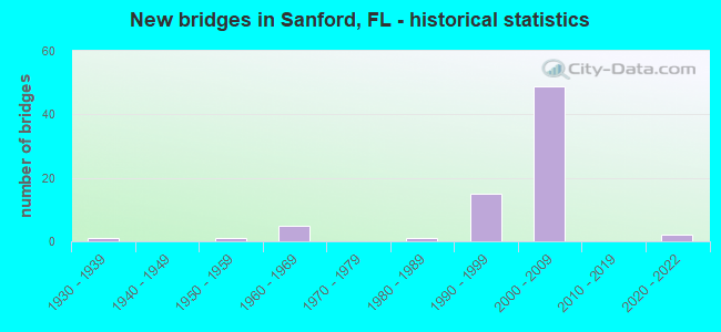
- New bridges - historical statistics
- 11930-1939
- 11950-1959
- 51960-1969
- 11980-1989
- 151990-1999
- 492000-2009
- 22020-2022

- Reconstructed bridges - Historical Statistics
- 41990-1999
- 12000-2009


- Bridge Condition - Deck
- 2.9%Excellent
- 2.9%Very good
- 91.2%Good
- 2.9%Satisfactory

- Bridge Condition - Superstructure
- 2.9%Excellent
- 26.5%Very good
- 70.6%Good

- Bridge Condition - Substructure
- 2.9%Excellent
- 17.6%Very good
- 73.5%Good
- 5.9%Satisfactory

- Bridge Condition - Channel
- 60.0%Good
- 20.0%Satisfactory
- 20.0%Fair

- Bridge Condition - Culverts
- 75.0%Good
- 25.0%Satisfactory
Find on map >> Show street view
Structure Number: 770084, Location: I-4-WB over SR-46 (Lat: 28.811297, Lng: -81.338142), Route carried "under" structure: State highway 46, Year Built: 2004, Structure Length: 0. m, Average Daily Traffic: 30,500 (year 2020), Truck Traffic: 12%, Features Intersected: SR-46, Facility Carried by Structure: I-4 WB
Minimum Vertical Clearance: 5.94m (19.49ft), Kilometerpoint: 8.027, Lanes on structure: 5, Lanes under structure: 8, Material/Design: Steel, Design/Construction: Stringer/Multi-beam, Length of Maximum Span: 61.1m (200.5ft)
Find on map >> Show street view
Structure Number: 770085, Location: I-4 EB over SR-46 (Lat: 28.811289, Lng: -81.337619), Route carried "under" structure: State highway 46, Year Built: 2003, Structure Length: 0. m, Average Daily Traffic: 30,500 (year 2020), Truck Traffic: 9%, Features Intersected: SR-46, Facility Carried by Structure: I-4 EB
Minimum Vertical Clearance: 5.94m (19.49ft), Kilometerpoint: 8.027, Lanes on structure: 4, Lanes under structure: 8, Material/Design: Steel, Design/Construction: Stringer/Multi-beam, Length of Maximum Span: 61.1m (200.5ft)
Find on map >> Show street view
Structure Number: 770086, Location: I-4WB-Orange Blvd & CSXRR (Lat: 28.829983, Lng: -81.325147), Route carried "under" structure: County highway , Year Built: 2003, Structure Length: 0. m, Average Daily Traffic: 15,000 (year 2005), Truck Traffic: 2%, Features Intersected: Orange Blvd & CSXRR, Facility Carried by Structure: I-4 WB
Minimum Vertical Clearance: 6.89m (22.60ft), Kilometerpoint: 0.000, Lanes on structure: 3, Lanes under structure: 2, Material/Design: Steel continuous, Design/Construction: Stringer/Multi-beam, Length of Maximum Span: 42.7m (140.1ft)
Find on map >> Show street view
Structure Number: 770087, Location: I-4EB - Orange Blvd & RR (Lat: 28.829650, Lng: -81.324647), Route carried "under" structure: County highway , Year Built: 2003, Structure Length: 0. m, Average Daily Traffic: 15,000 (year 2007), Truck Traffic: 2%, Features Intersected: Orange Blvd.& CSX RR., Facility Carried by Structure: I-4 EB
Minimum Vertical Clearance: 6.92m (22.70ft), Kilometerpoint: 0.000, Lanes on structure: 3, Lanes under structure: 2, Material/Design: Steel continuous, Design/Construction: Stringer/Multi-beam, Length of Maximum Span: 37.7m (123.7ft)
Find on map >> Show street view
Structure Number: 770088, Location: Ramp D1-Orange Blvd&CSXRR (Lat: 28.830089, Lng: -81.325386), Route carried "under" structure: County highway , Year Built: 2004, Structure Length: 0. m, Average Daily Traffic: 15,000 (year 2004), Truck Traffic: 2%, Features Intersected: Orange Blvd & CSXRR, Facility Carried by Structure: Ramp D1
Minimum Vertical Clearance: 6.22m (20.41ft), Kilometerpoint: 0.000, Lanes on structure: 1, Lanes under structure: 2, Material/Design: Prestressed concrete, Design/Construction: Stringer/Multi-beam, Length of Maximum Span: 37.5m (123.0ft)
Find on map >> Show street view
Structure Number: 770135, Location: I-4 EB Exit Ramp-Ramp L1 (Lat: 28.790833, Lng: -81.347222), Route carried "under" structure: Interstate 417, Year Built: 2021, Structure Length: 0. m, Average Daily Traffic: 5,600 (year 2021), Truck Traffic: 8%, Features Intersected: Ramp O1, Facility Carried by Structure: Ramp L1
Minimum Vertical Clearance: 6.07m (19.91ft), Kilometerpoint: 1.395, Lanes on structure: 3, Lanes under structure: 1, Toll: On toll road, Material/Design: Prestressed concrete, Design/Construction: Stringer/Multi-beam, Length of Maximum Span: 54.8m (179.8ft)
Find on map >> Show street view
Structure Number: 7706, Location: 0.3 MI SOUTH OF US 17 92 (Lat: 28.769381, Lng: -81.275492), Route carried "under" structure: County highway , Year Built: 2002, Structure Length: 0. m, Average Daily Traffic: 4,800 (year 2020), Truck Traffic: 6%, Features Intersected: AIRPORT BLVD, Facility Carried by Structure: SR 417 SB 50.0
Minimum Vertical Clearance: 5.26m (17.26ft), Kilometerpoint: 0.534, Lanes on structure: 2, Lanes under structure: 3, Material/Design: Prestressed concrete, Design/Construction: Stringer/Multi-beam, Length of Maximum Span: 30.7m (100.7ft)
Find on map >> Show street view
Structure Number: 770601, Location: 0.9MI NORTH OF CR 427 (Lat: 28.769408, Lng: -81.275119), Route carried "under" structure: County highway , Year Built: 2002, Structure Length: 0. m, Average Daily Traffic: 4,800 (year 2020), Truck Traffic: 6%, Features Intersected: AIRPORT BLVD, Facility Carried by Structure: SR 417 NB 50.0
Minimum Vertical Clearance: 7.22m (23.69ft), Kilometerpoint: 0.568, Lanes on structure: 2, Lanes under structure: 3, Material/Design: Prestressed concrete, Design/Construction: Stringer/Multi-beam, Length of Maximum Span: 27.8m (91.2ft)
Find on map >> Show street view
Structure Number: 770602, Location: 1.2 MI NORTH OF CR 427 (Lat: 28.771075, Lng: -81.279908), Route carried "under" structure: US 17, Year Built: 2002, Structure Length: 0. m, Average Daily Traffic: 28,500 (year 2020), Truck Traffic: 4%, Features Intersected: US 17 92
Minimum Vertical Clearance: 5.21m (17.09ft), Kilometerpoint: 16.831, Lanes on structure: 3, Lanes under structure: 4, Material/Design: Steel, Design/Construction: Stringer/Multi-beam, Length of Maximum Span: 47.0m (154.2ft)
Find on map >> Show street view
Structure Number: 770603, Location: 1.2MI NORTH OF CR 427 (Lat: 28.771331, Lng: -81.279756), Route carried "under" structure: US 17, Year Built: 2002, Structure Length: 0. m, Average Daily Traffic: 28,500 (year 2020), Truck Traffic: 4%, Features Intersected: US 17 92
Minimum Vertical Clearance: 5.75m (18.86ft), Kilometerpoint: 16.861, Lanes on structure: 3, Lanes under structure: 4, Material/Design: Steel, Design/Construction: Stringer/Multi-beam, Length of Maximum Span: 46.9m (153.9ft)
Find on map >> Show street view
Structure Number: 770604, Location: 1.3 MI NORTH OF CR 427 (Lat: 28.771528, Lng: -81.283597), Route carried "under" structure: County highway , Year Built: 2002, Structure Length: 0. m, Average Daily Traffic: 6,200 (year 2020), Truck Traffic: 13%, Features Intersected: AIRPORT BLVD, Facility Carried by Structure: SR 417 SB 50.5
Minimum Vertical Clearance: 5.49m (18.01ft), Kilometerpoint: 1.078, Lanes on structure: 2, Lanes under structure: 4, Material/Design: Steel, Design/Construction: Stringer/Multi-beam, Length of Maximum Span: 54.7m (179.5ft)
Find on map >> Show street view
Structure Number: 770605, Location: 1.2 MI NORTH OF CR 427 (Lat: 28.771819, Lng: -81.283900), Route carried "under" structure: County highway , Year Built: 2002, Structure Length: 0. m, Average Daily Traffic: 6,200 (year 2020), Truck Traffic: 13%, Features Intersected: AIRPORT BLVD, Facility Carried by Structure: SR 417 NB 50.5
Minimum Vertical Clearance: 5.04m (16.54ft), Kilometerpoint: 1.078, Lanes on structure: 2, Lanes under structure: 4, Material/Design: Steel, Design/Construction: Stringer/Multi-beam, Length of Maximum Span: 63.3m (207.7ft)
Find on map >> Show street view
Structure Number: 770606, Location: 2.1 MI NORTH OF CR 427 (Lat: 28.774506, Lng: -81.293492), Route carried "under" structure: City street , Year Built: 2002, Structure Length: 0. m, Average Daily Traffic: 22,875 (year 2020), Truck Traffic: 12%, Features Intersected: LIVE OAK BLVD, Facility Carried by Structure: SR 417 SB 51.1
Minimum Vertical Clearance: 5.67m (18.60ft), Kilometerpoint: 21.720, Lanes on structure: 2, Lanes under structure: 2, Material/Design: Prestressed concrete, Design/Construction: Stringer/Multi-beam, Length of Maximum Span: 24.0m (78.7ft)
Find on map >> Show street view
Structure Number: 770607, Location: 1.9 MI NORTH OF CR 427 (Lat: 28.774633, Lng: -81.293244), Route carried "under" structure: City street , Year Built: 2002, Structure Length: 0. m, Average Daily Traffic: 22,875 (year 2020), Truck Traffic: 12%, Features Intersected: LIVE OAK BLVD, Facility Carried by Structure: SR 417 NB 51.1
Minimum Vertical Clearance: 5.26m (17.26ft), Kilometerpoint: 21.720, Lanes on structure: 2, Lanes under structure: 2, Material/Design: Prestressed concrete, Design/Construction: Stringer/Multi-beam, Length of Maximum Span: 24.0m (78.7ft)
Find on map >> Show street view
Structure Number: 770608, Location: 2.3 MI NORTH OF CR 427 (Lat: 28.778506, Lng: -81.298247), Route carried "under" structure: City street , Year Built: 2002, Structure Length: 0. m, Average Daily Traffic: 7,700 (year 2020), Truck Traffic: 4%, Features Intersected: CSX RR & OLD LK MARY BLV, Facility Carried by Structure: SR 417 SB 51.3
Minimum Vertical Clearance: 7.75m (25.43ft), Kilometerpoint: 3.338, Lanes on structure: 2, Lanes under structure: 3, Material/Design: Prestressed concrete, Design/Construction: Stringer/Multi-beam, Length of Maximum Span: 38.7m (127.0ft)
Find on map >> Show street view
Structure Number: 770609, Location: 2.3 MI NORTH OF CR 427 (Lat: 28.778711, Lng: -81.298089), Route carried "under" structure: City street , Year Built: 2002, Structure Length: 0. m, Average Daily Traffic: 7,700 (year 2020), Truck Traffic: 4%, Features Intersected: CSX RR & OLD LK MARY BLV, Facility Carried by Structure: SR 417 NB 51.3
Minimum Vertical Clearance: 7.14m (23.43ft), Kilometerpoint: 3.368, Lanes on structure: 2, Lanes under structure: 3, Material/Design: Prestressed concrete, Design/Construction: Stringer/Multi-beam, Length of Maximum Span: 38.1m (125.0ft)
Find on map >> Show street view
Structure Number: 77061, Location: 1.7 MI N OF US 17 92 (Lat: 28.786467, Lng: -81.301639), Route carried "under" structure: Alternate County highway 46A, Year Built: 2001, Structure Length: 0. m, Average Daily Traffic: 22,500 (year 2020), Truck Traffic: 4%, Features Intersected: CR 46A, Facility Carried by Structure: SR 417 SB 52.1
Minimum Vertical Clearance: 5.28m (17.32ft), Kilometerpoint: 13.388, Lanes on structure: 2, Lanes under structure: 6, Material/Design: Prestressed concrete, Design/Construction: Stringer/Multi-beam, Length of Maximum Span: 38.2m (125.3ft)
Find on map >> Show street view
Structure Number: 770611, Location: 1.7 MI N OF US 17 92 (Lat: 28.786461, Lng: -81.301356), Route carried "under" structure: Alternate County highway 46A, Year Built: 2001, Structure Length: 0. m, Average Daily Traffic: 22,500 (year 2020), Truck Traffic: 4%, Features Intersected: CR 46A, Facility Carried by Structure: SR 417 NB 52.1
Minimum Vertical Clearance: 5.16m (16.93ft), Kilometerpoint: 13.414, Lanes on structure: 2, Lanes under structure: 5, Material/Design: Prestressed concrete, Design/Construction: Stringer/Multi-beam, Length of Maximum Span: 38.3m (125.7ft)
Find on map >> Show street view
Structure Number: 770612, Location: 3.5 MI N OF US 17 92 (Lat: 28.799492, Lng: -81.316508), Route carried "under" structure: County highway 15, Year Built: 2001, Structure Length: 0. m, Average Daily Traffic: 2,500 (year 2000), Truck Traffic: 1%, Features Intersected: UPSALA RD CR 15, Facility Carried by Structure: SR 417 SB 53.7
Minimum Vertical Clearance: 5.66m (18.57ft), Kilometerpoint: 8.517, Lanes on structure: 2, Lanes under structure: 3, Material/Design: Prestressed concrete, Design/Construction: Stringer/Multi-beam, Length of Maximum Span: 35.7m (117.1ft)
Find on map >> Show street view
Structure Number: 770613, Location: 3.5 MI N OF US 17 92 (Lat: 28.799739, Lng: -81.316475), Route carried "under" structure: County highway 15, Year Built: 2001, Structure Length: 0. m, Average Daily Traffic: 2,500 (year 2000), Truck Traffic: 1%, Features Intersected: UPSALA RD CR 15, Facility Carried by Structure: SR 417 NB 53.7
Minimum Vertical Clearance: 5.92m (19.42ft), Kilometerpoint: 8.547, Lanes on structure: 2, Lanes under structure: 3, Material/Design: Prestressed concrete, Design/Construction: Stringer/Multi-beam, Length of Maximum Span: 35.7m (117.1ft)
Find on map >> Show street view
Structure Number: 770614, Location: 0.9 MI EAST OF I-4 (Lat: 28.797744, Lng: -81.332025), Route carried "under" structure: County highway 431B, Year Built: 2002, Structure Length: 0. m, Average Daily Traffic: 17,900 (year 2020), Truck Traffic: 4%, Features Intersected: SR 341B (RINEHART RD), Facility Carried by Structure: SR 417 SB 54.6
Minimum Vertical Clearance: 5.83m (19.13ft), Kilometerpoint: 5.494, Lanes on structure: 2, Lanes under structure: 6, Material/Design: Steel, Design/Construction: Stringer/Multi-beam, Length of Maximum Span: 75.4m (247.4ft)
Find on map >> Show street view
Structure Number: 770615, Location: 0.9 MI EAST OF I-4 (Lat: 28.798056, Lng: -81.331819), Route carried "under" structure: County highway 431B, Year Built: 2002, Structure Length: 0. m, Average Daily Traffic: 17,900 (year 2020), Truck Traffic: 4%, Features Intersected: CR 431B (RINEHART RD), Facility Carried by Structure: SR 417 NB 54.6
Minimum Vertical Clearance: 6.28m (20.60ft), Kilometerpoint: 5.535, Lanes on structure: 3, Lanes under structure: 6, Material/Design: Steel, Design/Construction: Stringer/Multi-beam, Length of Maximum Span: 75.4m (247.4ft)
Find on map >> Show street view
Structure Number: 770616, Location: 0.4 MI E OF I-4 (Lat: 28.796511, Lng: -81.338811), Route carried "under" structure: City street , Year Built: 2002, Structure Length: 0. m, Average Daily Traffic: 14,000 (year 2016), Truck Traffic: 17%, Features Intersected: TOWN CENTER BLVD, Facility Carried by Structure: SR 417 SB 55.0
Minimum Vertical Clearance: 5.43m (17.81ft), Kilometerpoint: 0.000, Lanes on structure: 2, Lanes under structure: 4, Material/Design: Prestressed concrete, Design/Construction: Stringer/Multi-beam, Length of Maximum Span: 37.6m (123.4ft)
Find on map >> Show street view
Structure Number: 770617, Location: 0.4 MI E OF I-4 (Lat: 28.796789, Lng: -81.338700), Route carried "under" structure: City street , Year Built: 2002, Structure Length: 0. m, Average Daily Traffic: 14,000 (year 2016), Truck Traffic: 17%, Features Intersected: TOWN CENTER BLVD, Facility Carried by Structure: SR 417 NB 55.0
Minimum Vertical Clearance: 5.04m (16.54ft), Kilometerpoint: 0.000, Lanes on structure: 3, Lanes under structure: 4, Material/Design: Prestressed concrete, Design/Construction: Stringer/Multi-beam, Length of Maximum Span: 37.6m (123.4ft)
Find on map >> Show street view
Structure Number: 77091, Location: I-4 EB - Ramp A1 and C1 (Lat: 28.796189, Lng: -81.345369), Route carried "under" structure: Ramp Other road , Year Built: 1963, Structure Length: 0. m, Average Daily Traffic: 5,400 (year 2020), Truck Traffic: 8%, Features Intersected: SR-417, Facility Carried by Structure: I-4 EB
Minimum Vertical Clearance: 6.74m (22.11ft), Kilometerpoint: 0.439, Lanes on structure: 3, Lanes under structure: 2, Toll: On toll road, Material/Design: Prestressed concrete, Design/Construction: Stringer/Multi-beam, Length of Maximum Span: 16.2m (53.1ft)