Bridge Statistics for Santa Fe Springs, California (CA)
Condition, Traffic, Stress, Structural Evaluation, Project Costs
- National Bridge Inventory (NBI) Statistics
- 58Number of bridges
- 538ft / 164mTotal length
- $2,148,000Total costs
- 4,912,190Total average daily traffic
- 394,253Total average daily truck traffic
- National Bridge Inventory (NBI) Registered Bridges for Santa Fe Springs
- No street view available for this location
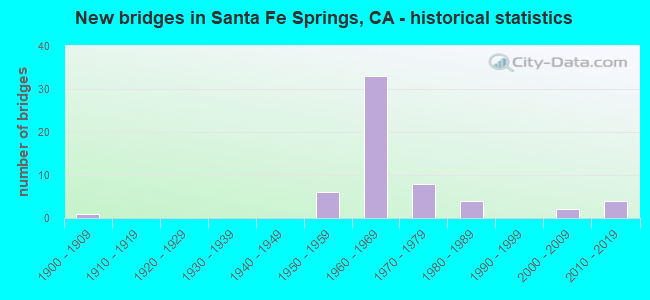
- New bridges - historical statistics
- 11900-1909
- 61950-1959
- 331960-1969
- 81970-1979
- 41980-1989
- 22000-2009
- 42010-2019


- Bridge Condition - Deck
- 70.4%Good
- 7.4%Satisfactory
- 14.8%Fair
- 7.4%Poor

- Bridge Condition - Superstructure
- 3.7%Very good
- 81.5%Good
- 11.1%Fair
- 3.7%Poor

- Bridge Condition - Substructure
- 96.3%Good
- 3.7%Fair

- Bridge Condition - Channel
- 64.3%Excellent
- 21.4%Very good
- 7.1%Good
- 7.1%Fair

- Bridge Condition - Culverts
- 20.0%Very good
- 60.0%Good
- 20.0%Satisfactory
Find on map >> Show street view
Structure Number: 53 1083F, Location: 07-LA-605-R9.65-SFSP (Lat: 33.942189, Lng: -118.097644), Route carried "on" structure: Ramp Interstate 605, Year Built: 1965, Status: Open, Structure Length: 7.13m (23.39ft), Average Daily Traffic: 22,700 (year 2012), Truck Traffic: 2%, Average Future Daily Traffic: 33,023 (year 2039), Design Load: HS 20, Features Intersected: ROUTE 5
Minimum Vertical Clearance: 30+ m (98+ ft), Kilometerpoint: 9.650, Lanes on structure: 2, Lanes under structure: 8, Base Highway Network: Yes (Inventory Route: 6, Subroute: 1), Owner: State Highway Agency, Approaching Roadway Width: 8.6m (28.2ft), Skew: 2 degrees, Material/Design: Prestressed concrete, Design/Construction: Stringer/Multi-beam, Number Of Spans In Main Unit: 2, Number Of Approach Spans: 2, Length of Maximum Span: 31.0m (101.7ft), Curb or Sidewalk Widths: Left: 0.6m (2.0ft), Right: 0.6m (2.0ft), Curb-To-Curb Width: 8.6m (28.2ft), Out-to-Out Width: 10.4m (34.1ft)
Condition: Deck: Good, Superstructure: Good, Substructure: Good, Operating Rating: 36.0 metric tons, Method Used To Determine Operating Rating: Load and Resistance Factor Rating (LRFR) rating reported by rating factor(RF) method using HL-93 loadings, Inventory Rating: 27.9 metric tons, Method Used To Determine Inventory Rating: Load and Resistance Factor Rating (LRFR) rating reported by rating factor(RF) method using HL-93 loadings, Structural Evaluation: Better than present minimum criteria, Deck Geometry: Meets minimum limits, Underclear: High priority of corrective action, Approach Roadway Alignment: Superior to present desirable criteria, Designated Inspection Frequency: Every 24 months, Inspection Date: September 2021, Deck Structure Type: Concrete Cast-file-Place
Find on map >> Show street view
Structure Number: 53 1521K, Location: 07-LA-405-22.55-ING (Lat: 33.949803, Lng: -118.369250), Route carried "on" structure: Bypass City street , Year Built: 1963, Status: Open, Structure Length: 4.33m (14.21ft), Average Daily Traffic: 11,200 (year 2019), Truck Traffic: 5%, Average Future Daily Traffic: 13,140 (year 2038), Design Load: HS 20, Features Intersected: S405-CENTURY BLVD OFF-RP, Facility Carried by Structure: OLIVE ST-S405 ONRP
Minimum Vertical Clearance: 30+ m (98+ ft), Kilometerpoint: 0.000, Lanes on structure: 2, Lanes under structure: 2, Base Highway Network: Yes, Owner: State Highway Agency, Approaching Roadway Width: 10.1m (33.1ft), Skew: 6 degrees, Material/Design: Concrete, Design/Construction: Slab, Number Of Spans In Main Unit: 1, Length of Maximum Span: 39.0m (128.0ft), Curb-To-Curb Width: 10.2m (33.5ft), Out-to-Out Width: 11.1m (36.4ft)
Condition: Deck: Good, Superstructure: Good, Substructure: Good, Operating Rating: 71.6 metric tons, Method Used To Determine Operating Rating: Load Factor (LF), Inventory Rating: 43.1 metric tons, Method Used To Determine Inventory Rating: Load Factor (LF), Structural Evaluation: Better than present minimum criteria, Deck Geometry: High priority of corrective action, Underclear: Meets minimum limits, Approach Roadway Alignment: Equal to present desirable criteria, Designated Inspection Frequency: Every 24 months, Inspection Date: January 2021, Deck Structure Type: Concrete Cast-file-Place
Find on map >> Show street view
Structure Number: 53 1529, Location: 07-LA-605-R13.98-SFSP (Lat: 33.999303, Lng: -118.067422), Route carried "on" structure: City street , Year Built: 1964, Status: Open, Structure Length: 6.81m (22.34ft), Average Daily Traffic: 900 (year 2015), Truck Traffic: 4%, Average Future Daily Traffic: 1,283 (year 2040), Design Load: HS 20, Features Intersected: INTERSTATE 605, Facility Carried by Structure: OBREGON STREET
Minimum Vertical Clearance: 30+ m (98+ ft), Kilometerpoint: 0.000, Lanes on structure: 2, Lanes under structure: 8, Base Highway Network: Yes, Owner: State Highway Agency, Approaching Roadway Width: 9.1m (29.9ft), Material/Design: Concrete continuous, Design/Construction: Box Beam or Girders - Multiple, Number Of Spans In Main Unit: 4, Length of Maximum Span: 22.4m (73.5ft), Curb or Sidewalk Widths: Left: 0.6m (2.0ft), Right: 1.8m (5.9ft), Curb-To-Curb Width: 9.1m (29.9ft), Out-to-Out Width: 12.2m (40.0ft)
Condition: Deck: Good, Superstructure: Good, Substructure: Good, Operating Rating: 37.3 metric tons, Method Used To Determine Operating Rating: Load and Resistance Factor Rating (LRFR) rating reported by rating factor(RF) method using HL-93 loadings, Inventory Rating: 28.8 metric tons, Method Used To Determine Inventory Rating: Load and Resistance Factor Rating (LRFR) rating reported by rating factor(RF) method using HL-93 loadings, Structural Evaluation: Better than present minimum criteria, Deck Geometry: Equal to present minimum criteria, Underclear: High priority of corrective action, Approach Roadway Alignment: Equal to present desirable criteria, Designated Inspection Frequency: Every 24 months, Inspection Date: March 2020, Deck Structure Type: Concrete Cast-file-Place
Find on map >> Show street view
Structure Number: 53 1657G, Location: 07-LA-605-R9.52-SFSP (Lat: 33.939433, Lng: -118.095747), Route carried "on" structure: Ramp Interstate 605, Year Built: 1965, Status: Open, Structure Length: 8.10m (26.57ft), Average Daily Traffic: 35,880 (year 2012), Truck Traffic: 2%, Average Future Daily Traffic: 42,377 (year 2039), Design Load: HS 20, Features Intersected: ROUTE 5
Minimum Vertical Clearance: 30+ m (98+ ft), Kilometerpoint: 9.520, Lanes on structure: 2, Lanes under structure: 8, Base Highway Network: Yes (Inventory Route: 6, Subroute: 1), Owner: State Highway Agency, Approaching Roadway Width: 8.6m (28.2ft), Skew: 9 degrees, Material/Design: Prestressed concrete, Design/Construction: Stringer/Multi-beam, Number Of Spans In Main Unit: 2, Number Of Approach Spans: 2, Length of Maximum Span: 33.0m (108.3ft), Curb or Sidewalk Widths: Left: 0.6m (2.0ft), Right: 0.6m (2.0ft), Curb-To-Curb Width: 8.6m (28.2ft), Out-to-Out Width: 10.4m (34.1ft)
Condition: Deck: Good, Superstructure: Good, Substructure: Good, Operating Rating: 40.2 metric tons, Method Used To Determine Operating Rating: Load and Resistance Factor Rating (LRFR) rating reported by rating factor(RF) method using HL-93 loadings, Inventory Rating: 28.8 metric tons, Method Used To Determine Inventory Rating: Load and Resistance Factor Rating (LRFR) rating reported by rating factor(RF) method using HL-93 loadings, Structural Evaluation: Better than present minimum criteria, Deck Geometry: Meets minimum limits, Underclear: Meets minimum limits, Approach Roadway Alignment: Meets minimum limits, Designated Inspection Frequency: Every 24 months, Inspection Date: September 2021, Deck Structure Type: Concrete Cast-file-Place
Find on map >> Show street view
Structure Number: 53 1658S, Location: 07-LA-005-6.65-SFSP (Lat: 33.938569, Lng: -118.094075), Route carried "on" structure: Ramp Interstate 5, Year Built: 1965, Status: Open, Structure Length: 7.99m (26.21ft), Average Daily Traffic: 840 (year 2010), Truck Traffic: 4%, Average Future Daily Traffic: 2,047 (year 2038), Design Load: HS 20, Features Intersected: N5-N&S605 CONNECTOR RAMP
Minimum Vertical Clearance: 30+ m (98+ ft), Kilometerpoint: 6.650, Lanes on structure: 1, Lanes under structure: 2, Owner: State Highway Agency, Approaching Roadway Width: 7.9m (25.9ft), Skew: 9 degrees, Material/Design: Concrete continuous, Design/Construction: Box Beam or Girders - Multiple, Number Of Spans In Main Unit: 3, Length of Maximum Span: 32.3m (106.0ft), Curb or Sidewalk Widths: Left: 0.6m (2.0ft), Right: 0.0m, Curb-To-Curb Width: 8.2m (26.9ft), Out-to-Out Width: 10.0m (32.8ft)
Condition: Deck: Good, Superstructure: Fair, Substructure: Good, Operating Rating: 35.6 metric tons, Method Used To Determine Operating Rating: Load and Resistance Factor Rating (LRFR) rating reported by rating factor(RF) method using HL-93 loadings, Inventory Rating: 27.5 metric tons, Method Used To Determine Inventory Rating: Load and Resistance Factor Rating (LRFR) rating reported by rating factor(RF) method using HL-93 loadings, Structural Evaluation: Somewhat better than minimum adequacy, Deck Geometry: Superior to present desirable criteria, Underclear: Meets minimum limits, Approach Roadway Alignment: Equal to present desirable criteria, Designated Inspection Frequency: Every 24 months, Inspection Date: November 2020, Deck Structure Type: Concrete Cast-file-Place
Find on map >> Show street view
Structure Number: 53 166, Location: 07-LA-605-R9.55-SFSP (Lat: 33.940311, Lng: -118.096822), Route carried "on" structure: Interstate 605, Year Built: 1965, Year Reconstructed: 1996, Status: Open, Structure Length: 17.29m (56.73ft), Average Daily Traffic: 298,000 (year 2012), Truck Traffic: 6%, Average Future Daily Traffic: 276,624 (year 2039), Design Load: HS 20, Features Intersected: I 5 & CONNECTOR RAMPS
Minimum Vertical Clearance: 30+ m (98+ ft), Kilometerpoint: 9.550, Lanes on structure: 10, Lanes under structure: 11, Base Highway Network: Yes (Inventory Route: 6, Subroute: 3), Owner: State Highway Agency, Approaching Roadway Width: 45.2m (148.3ft), Skew: 39 degrees, Material/Design: Prestressed concrete, Design/Construction: Stringer/Multi-beam, Number Of Spans In Main Unit: 2, Number Of Approach Spans: 6, Length of Maximum Span: 29.5m (96.8ft), Curb-To-Curb Width: 45.2m (148.3ft), Out-to-Out Width: 46.9m (153.9ft)
Condition: Deck: Good, Superstructure: Good, Substructure: Good, Operating Rating: 57.3 metric tons, Method Used To Determine Operating Rating: Load Factor (LF), Inventory Rating: 32.4 metric tons, Method Used To Determine Inventory Rating: Load Factor (LF), Structural Evaluation: Better than present minimum criteria, Deck Geometry: Superior to present desirable criteria, Underclear: High priority of corrective action, Approach Roadway Alignment: Superior to present desirable criteria, Designated Inspection Frequency: Every 24 months, Inspection Date: September 2021, Deck Structure Type: Concrete Cast-file-Place
Find on map >> Show street view
Structure Number: 53 1661, Location: 07-LA-605-R9.94-SFSP (Lat: 33.945628, Lng: -118.094072), Route carried "on" structure: Interstate 605, Year Built: 1965, Status: Open, Structure Length: 4.21m (13.81ft), Average Daily Traffic: 264,000 (year 2012), Truck Traffic: 11%, Average Future Daily Traffic: 268,410 (year 2039), Design Load: HS 20, Features Intersected: DAVENRICH STREET
Minimum Vertical Clearance: 30+ m (98+ ft), Kilometerpoint: 9.940, Lanes on structure: 13, Lanes under structure: 2, Base Highway Network: Yes (Inventory Route: 6, Subroute: 3), Owner: State Highway Agency, Approaching Roadway Width: 57.5m (188.6ft), Skew: 32 degrees, Material/Design: Concrete continuous, Design/Construction: Box Beam or Girders - Multiple, Number Of Spans In Main Unit: 3, Length of Maximum Span: 20.6m (67.6ft), Curb-To-Curb Width: 57.5m (188.6ft), Out-to-Out Width: 58.9m (193.2ft)
Condition: Deck: Good, Superstructure: Good, Substructure: Good, Operating Rating: 98.5 metric tons, Method Used To Determine Operating Rating: Assigned rating based on Load Factor Design (LFD) reported in metric tons, Inventory Rating: 59.0 metric tons, Method Used To Determine Inventory Rating: Assigned rating based on Load Factor Design (LFD) reported in metric tons, Structural Evaluation: Better than present minimum criteria, Deck Geometry: Superior to present desirable criteria, Underclear: Better than present minimum criteria, Approach Roadway Alignment: Superior to present desirable criteria, Designated Inspection Frequency: Every 24 months, Inspection Date: September 2021, Deck Structure Type: Concrete Cast-file-Place
Find on map >> Show street view
Structure Number: 53 1662, Location: 07-LA-605-R10.25-SFSP (Lat: 33.949442, Lng: -118.091767), Route carried "on" structure: Interstate 605, Year Built: 1965, Year Reconstructed: 1996, Status: Open, Structure Length: 4.89m (16.04ft), Average Daily Traffic: 264,000 (year 2012), Truck Traffic: 11%, Average Future Daily Traffic: 268,410 (year 2039), Design Load: HS 20, Features Intersected: TELEGRAPH RD
Minimum Vertical Clearance: 5.20m (17.06ft), Kilometerpoint: 10.250, Lanes on structure: 12, Lanes under structure: 6, Base Highway Network: Yes (Inventory Route: 6, Subroute: 3), Owner: State Highway Agency, Approaching Roadway Width: 55.2m (181.1ft), Skew: 30 degrees, Material/Design: Prestressed concrete, Design/Construction: Stringer/Multi-beam, Number Of Spans In Main Unit: 2, Number Of Approach Spans: 2, Length of Maximum Span: 15.9m (52.2ft), Curb-To-Curb Width: 55.2m (181.1ft), Out-to-Out Width: 56.7m (186.0ft)
Condition: Deck: Good, Superstructure: Good, Substructure: Good, Operating Rating: 29.2 metric tons, Method Used To Determine Operating Rating: Load and Resistance Factor Rating (LRFR) rating reported by rating factor(RF) method using HL-93 loadings, Inventory Rating: 22.7 metric tons, Method Used To Determine Inventory Rating: Load and Resistance Factor Rating (LRFR) rating reported by rating factor(RF) method using HL-93 loadings, Structural Evaluation: Somewhat better than minimum adequacy, Deck Geometry: Superior to present desirable criteria, Underclear: Meets minimum limits, Approach Roadway Alignment: Superior to present desirable criteria, Designated Inspection Frequency: Every 24 months, Inspection Date: September 2021, Deck Structure Type: Concrete Cast-file-Place
Find on map >> Show street view
Structure Number: 53 1663, Location: 07-LA-605-R11.20-SFSP (Lat: 33.962214, Lng: -118.085228), Route carried "on" structure: Interstate 605, Year Built: 1965, Status: Open, Structure Length: 7.12m (23.36ft), Average Daily Traffic: 264,000 (year 2012), Truck Traffic: 11%, Average Future Daily Traffic: 268,410 (year 2039), Design Load: HS 20, Features Intersected: UP RR & AMTRAK
Minimum Vertical Clearance: 30+ m (98+ ft), Kilometerpoint: 11.200, Lanes on structure: 10, Base Highway Network: Yes (Inventory Route: 6, Subroute: 3), Owner: State Highway Agency, Approaching Roadway Width: 41.5m (136.2ft), Skew: 39 degrees, Material/Design: Concrete continuous, Design/Construction: Box Beam or Girders - Multiple, Number Of Spans In Main Unit: 4, Length of Maximum Span: 28.5m (93.5ft), Curb-To-Curb Width: 41.5m (136.2ft), Out-to-Out Width: 42.9m (140.7ft)
Condition: Deck: Fair, Superstructure: Good, Substructure: Good, Operating Rating: 34.0 metric tons, Method Used To Determine Operating Rating: Load and Resistance Factor Rating (LRFR) rating reported by rating factor(RF) method using HL-93 loadings, Inventory Rating: 26.2 metric tons, Method Used To Determine Inventory Rating: Load and Resistance Factor Rating (LRFR) rating reported by rating factor(RF) method using HL-93 loadings, Structural Evaluation: Equal to present minimum criteria, Deck Geometry: Somewhat better than minimum adequacy, Underclear: Better than present minimum criteria, Approach Roadway Alignment: Superior to present desirable criteria, Designated Inspection Frequency: Every 24 months, Inspection Date: September 2021, Deck Structure Type: Concrete Cast-file-Place
Find on map >> Show street view
Structure Number: 53 1664, Location: 07-LA-605-R11.39-SFSP (Lat: 33.964844, Lng: -118.084136), Route carried "on" structure: Interstate 605, Year Built: 1965, Status: Open, Structure Length: 9.65m (31.66ft), Average Daily Traffic: 264,000 (year 2012), Truck Traffic: 11%, Average Future Daily Traffic: 268,410 (year 2039), Design Load: HS 20, Features Intersected: BNSF RY & RIVERA RD
Minimum Vertical Clearance: 30+ m (98+ ft), Kilometerpoint: 11.390, Lanes on structure: 10, Lanes under structure: 2, Base Highway Network: Yes (Inventory Route: 6, Subroute: 3), Owner: State Highway Agency, Approaching Roadway Width: 42.0m (137.8ft), Skew: 30 degrees, Material/Design: Concrete continuous, Design/Construction: Box Beam or Girders - Multiple, Number Of Spans In Main Unit: 5, Length of Maximum Span: 21.6m (70.9ft), Curb-To-Curb Width: 42.0m (137.8ft), Out-to-Out Width: 44.0m (144.4ft)
Condition: Deck: Good, Superstructure: Good, Substructure: Good, Operating Rating: 32.1 metric tons, Method Used To Determine Operating Rating: Load and Resistance Factor Rating (LRFR) rating reported by rating factor(RF) method using HL-93 loadings, Inventory Rating: 24.6 metric tons, Method Used To Determine Inventory Rating: Load and Resistance Factor Rating (LRFR) rating reported by rating factor(RF) method using HL-93 loadings, Structural Evaluation: Equal to present minimum criteria, Deck Geometry: Equal to present minimum criteria, Underclear: Superior to present desirable criteria, Approach Roadway Alignment: Superior to present desirable criteria, Designated Inspection Frequency: Every 24 months, Inspection Date: September 2021, Deck Structure Type: Concrete Cast-file-Place
Find on map >> Show street view
Structure Number: 53 1665, Location: 07-LA-605-R11.54-SFSP (Lat: 33.966950, Lng: -118.083211), Route carried "on" structure: Interstate 605, Year Built: 1965, Status: Open, Structure Length: 6.07m (19.91ft), Average Daily Traffic: 264,000 (year 2012), Truck Traffic: 11%, Average Future Daily Traffic: 268,410 (year 2039), Design Load: HS 20, Features Intersected: SLAUSON AVE
Minimum Vertical Clearance: 30+ m (98+ ft), Kilometerpoint: 11.540, Lanes on structure: 11, Lanes under structure: 5, Base Highway Network: Yes (Inventory Route: 6, Subroute: 3), Owner: State Highway Agency, Approaching Roadway Width: 48.6m (159.4ft), Skew: 31 degrees, Material/Design: Concrete continuous, Design/Construction: Box Beam or Girders - Multiple, Number Of Spans In Main Unit: 3, Length of Maximum Span: 32.6m (107.0ft), Curb-To-Curb Width: 48.6m (159.4ft), Out-to-Out Width: 50.4m (165.4ft)
Condition: Deck: Good, Superstructure: Fair, Substructure: Good, Operating Rating: 90.4 metric tons, Method Used To Determine Operating Rating: Assigned rating based on Load Factor Design (LFD) reported in metric tons, Inventory Rating: 54.4 metric tons, Method Used To Determine Inventory Rating: Assigned rating based on Load Factor Design (LFD) reported in metric tons, Structural Evaluation: Somewhat better than minimum adequacy, Deck Geometry: Superior to present desirable criteria, Underclear: Better than present minimum criteria, Approach Roadway Alignment: Equal to present desirable criteria, Designated Inspection Frequency: Every 24 months, Inspection Date: September 2021, Deck Structure Type: Concrete Cast-file-Place
Find on map >> Show street view
Structure Number: 53 1666, Location: 07-LA-605-R11.80-SFSP (Lat: 33.970317, Lng: -118.081467), Route carried "on" structure: Interstate 605, Year Built: 1965, Status: Open, Structure Length: 3.48m (11.42ft), Average Daily Traffic: 264,000 (year 2012), Truck Traffic: 11%, Average Future Daily Traffic: 268,410 (year 2039), Design Load: HS 20, Features Intersected: WADDELL STREET
Minimum Vertical Clearance: 30+ m (98+ ft), Kilometerpoint: 11.800, Lanes on structure: 12, Lanes under structure: 2, Base Highway Network: Yes (Inventory Route: 6, Subroute: 3), Owner: State Highway Agency, Approaching Roadway Width: 55.2m (181.1ft), Skew: 31 degrees, Material/Design: Concrete continuous, Design/Construction: Box Beam or Girders - Multiple, Number Of Spans In Main Unit: 3, Length of Maximum Span: 19.0m (62.3ft), Curb-To-Curb Width: 55.2m (181.1ft), Out-to-Out Width: 56.6m (185.7ft)
Condition: Deck: Good, Superstructure: Good, Substructure: Good, Operating Rating: 44.1 metric tons, Method Used To Determine Operating Rating: Load and Resistance Factor Rating (LRFR) rating reported by rating factor(RF) method using HL-93 loadings, Inventory Rating: 34.0 metric tons, Method Used To Determine Inventory Rating: Load and Resistance Factor Rating (LRFR) rating reported by rating factor(RF) method using HL-93 loadings, Structural Evaluation: Better than present minimum criteria, Deck Geometry: Superior to present desirable criteria, Underclear: Equal to present minimum criteria, Approach Roadway Alignment: Equal to present desirable criteria, Designated Inspection Frequency: Every 24 months, Inspection Date: September 2021, Deck Structure Type: Concrete Cast-file-Place
Find on map >> Show street view
Structure Number: 53 1667, Location: 07-LA-605-R12.05-SFSP (Lat: 33.973700, Lng: -118.079750), Route carried "on" structure: Interstate 605, Year Built: 1965, Status: Open, Structure Length: 4.88m (16.01ft), Average Daily Traffic: 264,000 (year 2012), Truck Traffic: 11%, Average Future Daily Traffic: 268,410 (year 2039), Design Load: HS 20+Mod, Features Intersected: WASHINGTON BLVD
Minimum Vertical Clearance: 30+ m (98+ ft), Kilometerpoint: 12.050, Lanes on structure: 14, Lanes under structure: 6, Base Highway Network: Yes (Inventory Route: 6, Subroute: 3), Owner: State Highway Agency, Approaching Roadway Width: 67.0m (219.8ft), Skew: 30 degrees, Material/Design: Prestressed concrete, Design/Construction: Stringer/Multi-beam, Number Of Spans In Main Unit: 2, Number Of Approach Spans: 2, Length of Maximum Span: 15.9m (52.2ft), Curb or Sidewalk Widths: Left: 0.6m (2.0ft), Right: 0.0m, Curb-To-Curb Width: 67.0m (219.8ft), Out-to-Out Width: 69.0m (226.4ft)
Condition: Deck: Good, Superstructure: Good, Substructure: Good, Operating Rating: 43.4 metric tons, Method Used To Determine Operating Rating: Load and Resistance Factor Rating (LRFR) rating reported by rating factor(RF) method using HL-93 loadings, Inventory Rating: 21.4 metric tons, Method Used To Determine Inventory Rating: Load and Resistance Factor Rating (LRFR) rating reported by rating factor(RF) method using HL-93 loadings, Structural Evaluation: Somewhat better than minimum adequacy, Deck Geometry: Superior to present desirable criteria, Underclear: Meets minimum limits, Approach Roadway Alignment: Equal to present desirable criteria, Designated Inspection Frequency: Every 24 months, Inspection Date: September 2021, Deck Structure Type: Concrete Cast-file-Place
Find on map >> Show street view
Structure Number: 53 1668, Location: 07-LA-605-R12.41-SFSP (Lat: 33.978531, Lng: -118.077756), Route carried "on" structure: Interstate 605, Year Built: 1965, Status: Open, Structure Length: 3.78m (12.40ft), Average Daily Traffic: 264,000 (year 2012), Truck Traffic: 11%, Average Future Daily Traffic: 268,410 (year 2039), Design Load: HS 20, Features Intersected: SARAGOSA STREET
Minimum Vertical Clearance: 30+ m (98+ ft), Kilometerpoint: 12.410, Lanes on structure: 10, Lanes under structure: 3, Base Highway Network: Yes (Inventory Route: 6, Subroute: 3), Owner: State Highway Agency, Approaching Roadway Width: 41.4m (135.8ft), Skew: 30 degrees, Material/Design: Concrete continuous, Design/Construction: Box Beam or Girders - Multiple, Number Of Spans In Main Unit: 3, Length of Maximum Span: 18.3m (60.0ft), Curb-To-Curb Width: 41.4m (135.8ft), Out-to-Out Width: 43.0m (141.1ft)
Condition: Deck: Good, Superstructure: Good, Substructure: Good, Operating Rating: 40.5 metric tons, Method Used To Determine Operating Rating: Load and Resistance Factor Rating (LRFR) rating reported by rating factor(RF) method using HL-93 loadings, Inventory Rating: 31.4 metric tons, Method Used To Determine Inventory Rating: Load and Resistance Factor Rating (LRFR) rating reported by rating factor(RF) method using HL-93 loadings, Structural Evaluation: Better than present minimum criteria, Deck Geometry: Somewhat better than minimum adequacy, Underclear: Somewhat better than minimum adequacy, Approach Roadway Alignment: Equal to present desirable criteria, Designated Inspection Frequency: Every 24 months, Inspection Date: September 2021, Deck Structure Type: Concrete Cast-file-Place
Find on map >> Show street view
Structure Number: 53 1669, Location: 07-LA-605-R12.85-SFSP (Lat: 33.983453, Lng: -118.073044), Route carried "on" structure: Interstate 605, Year Built: 1965, Status: Open, Structure Length: 4.16m (13.65ft), Average Daily Traffic: 264,000 (year 2015), Truck Traffic: 11%, Average Future Daily Traffic: 268,410 (year 2040), Design Load: HS 20, Features Intersected: DUNLAP CROSSING ROAD
Minimum Vertical Clearance: 30+ m (98+ ft), Kilometerpoint: 12.850, Lanes on structure: 10, Lanes under structure: 2, Base Highway Network: Yes (Inventory Route: 6, Subroute: 3), Owner: State Highway Agency, Approaching Roadway Width: 41.0m (134.5ft), Skew: 30 degrees, Material/Design: Concrete continuous, Design/Construction: Box Beam or Girders - Multiple, Number Of Spans In Main Unit: 3, Length of Maximum Span: 25.1m (82.3ft), Curb-To-Curb Width: 41.0m (134.5ft), Out-to-Out Width: 42.9m (140.7ft)
Condition: Deck: Good, Superstructure: Good, Substructure: Good, Operating Rating: 89.7 metric tons, Method Used To Determine Operating Rating: Assigned rating based on Load Factor Design (LFD) reported in metric tons, Inventory Rating: 54.1 metric tons, Method Used To Determine Inventory Rating: Assigned rating based on Load Factor Design (LFD) reported in metric tons, Structural Evaluation: Better than present minimum criteria, Deck Geometry: Meets minimum limits, Underclear: Equal to present minimum criteria, Approach Roadway Alignment: Equal to present desirable criteria, Designated Inspection Frequency: Every 24 months, Inspection Date: March 2020, Deck Structure Type: Concrete Cast-file-Place
Find on map >> Show street view
Structure Number: 53 3037, Location: 07-LA-005-1.48-SFSP (Lat: 33.886769, Lng: -118.032953), Route carried "on" structure: Interstate 5, Year Built: 2015, Status: Open, Structure Length: 4.82m (15.81ft), Average Daily Traffic: 164,000 (year 2015), Truck Traffic: 5%, Average Future Daily Traffic: 255,857 (year 2037), Design Load: HL 93, Features Intersected: N.FK COYOTE CREEK, BIKE
Minimum Vertical Clearance: 30+ m (98+ ft), Kilometerpoint: 1.480, Lanes on structure: 7, Base Highway Network: Yes (, Subroute: 1), Owner: State Highway Agency, Approaching Roadway Width: 63.4m (208.0ft), Skew: 33 degrees, Material/Design: Prestressed concrete, Design/Construction: Box Beam or Girders - Multiple, Number Of Spans In Main Unit: 1, Number Of Approach Spans: 1, Length of Maximum Span: 36.1m (118.4ft), Curb-To-Curb Width: 63.4m (208.0ft), Out-to-Out Width: 65.7m (215.6ft)
Condition: Deck: Good, Superstructure: Fair, Substructure: Good, Channel: Good, Operating Rating: 42.1 metric tons, Method Used To Determine Operating Rating: Assigned ratings based on Load and Resistance Factor Design (LRFD) reported by rating factor (RF) using HL93 loadings, Inventory Rating: 32.4 metric tons, Method Used To Determine Inventory Rating: Assigned ratings based on Load and Resistance Factor Design (LRFD) reported by rating factor (RF) using HL93 loadings, Structural Evaluation: Somewhat better than minimum adequacy, Deck Geometry: Superior to present desirable criteria, Waterway Adequacy: Better than present minimum criteria, Approach Roadway Alignment: Equal to present desirable criteria, Designated Inspection Frequency: Every 24 months, Inspection Date: March 2020, Deck Structure Type: Concrete Cast-file-Place
Find on map >> Show street view
Structure Number: 53 3038, Location: 07-LA-005-1.67-SFSP (Lat: 33.887864, Lng: -118.036272), Route carried "on" structure: Business City street , Year Built: 2015, Status: Open, Structure Length: 12.56m (41.21ft), Average Daily Traffic: 10,000 (year 2018), Truck Traffic: 5%, Average Future Daily Traffic: 15,000 (year 2037), Design Load: HL 93, Features Intersected: INTERSTATE 5, Facility Carried by Structure: ALONDRA BLVD
Minimum Vertical Clearance: 30+ m (98+ ft), Kilometerpoint: 0.000, Lanes on structure: 6, Lanes under structure: 7, Owner: State Highway Agency, Approaching Roadway Width: 26.1m (85.6ft), Skew: 5 degrees, Material/Design: Prestressed concrete continuous, Design/Construction: Box Beam or Girders - Multiple, Number Of Spans In Main Unit: 2, Length of Maximum Span: 62.8m (206.0ft), Curb or Sidewalk Widths: Left: 1.8m (5.9ft), Right: 1.8m (5.9ft), Curb-To-Curb Width: 26.1m (85.6ft), Out-to-Out Width: 30.3m (99.4ft)
Condition: Deck: Good, Superstructure: Good, Substructure: Good, Operating Rating: 42.1 metric tons, Method Used To Determine Operating Rating: Assigned ratings based on Load and Resistance Factor Design (LRFD) reported by rating factor (RF) using HL93 loadings, Inventory Rating: 32.4 metric tons, Method Used To Determine Inventory Rating: Assigned ratings based on Load and Resistance Factor Design (LRFD) reported by rating factor (RF) using HL93 loadings, Structural Evaluation: Better than present minimum criteria, Deck Geometry: Equal to present minimum criteria, Underclear: Somewhat better than minimum adequacy, Approach Roadway Alignment: Equal to present desirable criteria, Designated Inspection Frequency: Every 24 months, Inspection Date: March 2020, Deck Structure Type: Concrete Cast-file-Place
Find on map >> Show street view
Structure Number: 53C0463, Location: 1.0MI N/O TELEGRAPH RD (Lat: 33.956042, Lng: -118.053406), Route carried "on" structure: City street L678, Year Built: 1959, Status: Open, Structure Length: 0.98m (3.22ft), Average Daily Traffic: 13,871 (year 2012), Truck Traffic: 5%, Average Future Daily Traffic: 15,952 (year 2040), Features Intersected: SORENSON DRN, Facility Carried by Structure: SANTA FE SPRINGS R
Minimum Vertical Clearance: 30.47m (99.97ft), Kilometerpoint: 0.000, Lanes on structure: 4, Owner: City or Municipal Highway Agency, Approaching Roadway Width: 24.4m (80.1ft), Skew: 29 degrees, Material/Design: Concrete, Design/Construction: Culvert, Number Of Spans In Main Unit: 3, Length of Maximum Span: 3.0m (9.8ft), Curb or Sidewalk Widths: Left: 3.0m (9.8ft), Right: 3.0m (9.8ft), Curb-To-Curb Width: 24.4m (80.1ft), Out-to-Out Width: 32.0m (105.0ft)
Condition: Channel: Excellent, Culverts: Good, Operating Rating: 40.5 metric tons, Method Used To Determine Operating Rating: Field evaluation and documented engineering judgment, Inventory Rating: 24.3 metric tons, Method Used To Determine Inventory Rating: Field evaluation and documented engineering judgment, Structural Evaluation: Equal to present minimum criteria, Deck Geometry: Superior to present desirable criteria, Waterway Adequacy: Superior to present desirable criteria, Approach Roadway Alignment: Equal to present desirable criteria, Designated Inspection Frequency: Every 24 months, Inspection Date: October 2020, Wearing Surface/Protective System: Wearing Surface: Bituminous
Find on map >> Show street view
Structure Number: 53C0464, Location: 0.8MI W/O VALLEY VIEW AVE (Lat: 33.902331, Lng: -118.041678), Route carried "on" structure: City street L079, Year Built: 1960, Status: Open, Structure Length: 4.30m (14.11ft), Average Daily Traffic: 29,859 (year 2012), Truck Traffic: 3%, Average Future Daily Traffic: 35,831 (year 2040), Design Load: HS 20, Features Intersected: COYOTE CR NF, Facility Carried by Structure: ROSECRANS AVE
Minimum Vertical Clearance: 30.47m (99.97ft), Kilometerpoint: 0.000, Lanes on structure: 4, Owner: City or Municipal Highway Agency, Approaching Roadway Width: 24.4m (80.1ft), Material/Design: Prestressed concrete, Design/Construction: Stringer/Multi-beam, Number Of Spans In Main Unit: 2, Length of Maximum Span: 21.0m (68.9ft), Curb or Sidewalk Widths: Left: 1.5m (4.9ft), Right: 1.6m (5.2ft), Curb-To-Curb Width: 24.4m (80.1ft), Out-to-Out Width: 27.8m (91.2ft)
Condition: Deck: Satisfactory, Superstructure: Good, Substructure: Good, Channel: Excellent, Operating Rating: 65.8 metric tons, Method Used To Determine Operating Rating: Load Factor (LF), Inventory Rating: 35.0 metric tons, Method Used To Determine Inventory Rating: Load Factor (LF), Structural Evaluation: Better than present minimum criteria, Deck Geometry: Superior to present desirable criteria, Waterway Adequacy: Superior to present desirable criteria, Approach Roadway Alignment: Equal to present desirable criteria, Designated Inspection Frequency: Every 48 months, Inspection Date: October 2020, Deck Structure Type: Concrete Cast-file-Place, Wearing Surface/Protective System: Wearing Surface: Monolithic Concrete
Find on map >> Show street view
Structure Number: 53C047, Location: 0.1MI N/O MULBERRY DRIVE (Lat: 33.937106, Lng: -118.011742), Route carried "on" structure: County highway Q765, Year Built: 1963, Status: Open, Structure Length: 1.00m (3.28ft), Average Daily Traffic: 16,218 (year 2014), Truck Traffic: 2%, Average Future Daily Traffic: 19,462 (year 2042), Design Load: HS 20, Features Intersected: LEFFINGWELL CR, Facility Carried by Structure: LA MIRADA BLVD
Minimum Vertical Clearance: 30.47m (99.97ft), Kilometerpoint: 0.000, Lanes on structure: 4, Owner: County Highway Agency, Approaching Roadway Width: 20.1m (65.9ft), Skew: 23 degrees, Material/Design: Concrete, Design/Construction: Slab, Number Of Spans In Main Unit: 1, Length of Maximum Span: 9.1m (29.9ft), Curb or Sidewalk Widths: Left: 1.5m (4.9ft), Right: 1.5m (4.9ft), Curb-To-Curb Width: 20.1m (65.9ft), Out-to-Out Width: 28.1m (92.2ft)
Condition: Deck: Poor, Superstructure: Poor, Substructure: Good, Channel: Excellent, Operating Rating: 59.0 metric tons, Method Used To Determine Operating Rating: Load Factor (LF), Inventory Rating: 35.3 metric tons, Method Used To Determine Inventory Rating: Load Factor (LF), Structural Evaluation: Meets minimum limits, Deck Geometry: Better than present minimum criteria, Waterway Adequacy: Superior to present desirable criteria, Approach Roadway Alignment: Equal to present desirable criteria, Designated Inspection Frequency: Every 24 months, Inspection Date: October 2021, Deck Structure Type: Concrete Cast-file-Place
Find on map >> Show street view
Structure Number: 53C062, Location: 4.0MI S/O US-101 FWY (Lat: 34.081131, Lng: -118.704097), Route carried "on" structure: County highway W483, Year Built: 1953, Status: Open, Structure Length: 6.61m (21.69ft), Average Daily Traffic: 20,753 (year 2012), Truck Traffic: 2%, Average Future Daily Traffic: 24,903 (year 2041), Design Load: HS 20, Features Intersected: MALIBU CRK, Facility Carried by Structure: MALIBU CYN RD
Minimum Vertical Clearance: 30.47m (99.97ft), Kilometerpoint: 0.000, Lanes on structure: 2, Owner: County Highway Agency, Approaching Roadway Width: 8.4m (27.6ft), Skew: 2 degrees, Material/Design: Concrete continuous, Design/Construction: Tee Beam, Number Of Spans In Main Unit: 3, Length of Maximum Span: 26.2m (86.0ft), Curb or Sidewalk Widths: Left: 0.0m, Right: 1.5m (4.9ft), Curb-To-Curb Width: 8.0m (26.2ft), Out-to-Out Width: 8.4m (27.6ft)
Condition: Deck: Poor, Superstructure: Good, Substructure: Good, Channel: Fair, Operating Rating: 28.8 metric tons, Method Used To Determine Operating Rating: Load Factor (LF), Inventory Rating: 17.5 metric tons, Method Used To Determine Inventory Rating: Load Factor (LF), Structural Evaluation: Meets minimum limits, Deck Geometry: High priority of corrective action, Waterway Adequacy: Better than present minimum criteria, Approach Roadway Alignment: Equal to present desirable criteria, Designated Inspection Frequency: Every 24 months, Inspection Date: April 2021, Bridge Improvement Cost: $1,278,000, Roadway Improvement Cost: $255,000, Total Project Cost: $2,148,000 ( Estimate for 2017), Deck Structure Type: Concrete Cast-file-Place
Find on map >> Show street view
Structure Number: 53C085, Location: 0.5MI W/O PARAMONT BLVD (Lat: 33.927258, Lng: -118.158953), Route carried "on" structure: County highway , Year Built: 1973, Status: Open, Structure Length: 5.73m (18.80ft), Average Daily Traffic: 35,000 (year 2016), Truck Traffic: 1%, Average Future Daily Traffic: 42,000 (year 2041), Features Intersected: IMPERIAL HIGHWAY, Facility Carried by Structure: ERICKSON AVE
Minimum Vertical Clearance: 30.47m (99.97ft), Kilometerpoint: 0.000, Lanes on structure: 4, Lanes under structure: 6, Owner: County Highway Agency, Approaching Roadway Width: 19.8m (65.0ft), Material/Design: Concrete, Design/Construction: Box Beam or Girders - Multiple, Number Of Spans In Main Unit: 1, Number Of Approach Spans: 2, Length of Maximum Span: 30.8m (101.0ft), Curb or Sidewalk Widths: Left: 0.0m, Right: 1.6m (5.2ft), Curb-To-Curb Width: 19.4m (63.6ft), Out-to-Out Width: 43.4m (142.4ft)
Condition: Deck: Fair, Superstructure: Good, Substructure: Fair, Operating Rating: 75.2 metric tons, Method Used To Determine Operating Rating: Load Factor (LF), Inventory Rating: 45.0 metric tons, Method Used To Determine Inventory Rating: Load Factor (LF), Structural Evaluation: Somewhat better than minimum adequacy, Deck Geometry: Better than present minimum criteria, Underclear: Meets minimum limits, Approach Roadway Alignment: Equal to present desirable criteria, Designated Inspection Frequency: Every 24 months, Inspection Date: March 2021, Deck Structure Type: Concrete Cast-file-Place, Wearing Surface/Protective System: Wearing Surface: Monolithic Concrete
Find on map >> Show street view
Structure Number: 53C144, Location: 0.2MI S/O ARTESIA BLVD (Lat: 33.871089, Lng: -118.298925), Route carried "on" structure: City street L018, Year Built: 1958, Status: Open, Structure Length: 2.38m (7.81ft), Average Daily Traffic: 21,420 (year 2012), Truck Traffic: 2%, Average Future Daily Traffic: 25,704 (year 2041), Design Load: HS 20, Features Intersected: DOMINGUEZ CHAN, Facility Carried by Structure: NORMANDIE AVE
Minimum Vertical Clearance: 30+ m (98+ ft), Kilometerpoint: 0.000, Lanes on structure: 5, Owner: City or Municipal Highway Agency, Approaching Roadway Width: 18.3m (60.0ft), Material/Design: Concrete continuous, Design/Construction: Culvert, Number Of Spans In Main Unit: 3, Length of Maximum Span: 7.3m (24.0ft), Curb or Sidewalk Widths: Left: 1.5m (4.9ft), Right: 1.5m (4.9ft), Curb-To-Curb Width: 18.3m (60.0ft), Out-to-Out Width: 24.5m (80.4ft)
Condition: Channel: Excellent, Culverts: Good, Operating Rating: 55.1 metric tons, Method Used To Determine Operating Rating: Load Factor (LF), Inventory Rating: 33.0 metric tons, Method Used To Determine Inventory Rating: Load Factor (LF), Structural Evaluation: Better than present minimum criteria, Deck Geometry: High priority of replacement, Waterway Adequacy: Superior to present desirable criteria, Approach Roadway Alignment: Equal to present desirable criteria, Designated Inspection Frequency: Every 48 months, Inspection Date: July 2021, Deck Structure Type: Concrete Cast-file-Place, Wearing Surface/Protective System: Wearing Surface: Bituminous
Find on map >> Show street view
Structure Number: 53C1443, Location: 0.4MI E/O CARMENITA AVE (Lat: 33.909667, Lng: -118.040839), Route carried "on" structure: City street Q841, Year Built: 1959, Status: Open, Structure Length: 4.02m (13.19ft), Average Daily Traffic: 3,672 (year 2012), Truck Traffic: 3%, Average Future Daily Traffic: 4,039 (year 2040), Design Load: HS 20, Features Intersected: COYOTE CRK NF, Facility Carried by Structure: FOSTER RD
Minimum Vertical Clearance: 30.47m (99.97ft), Kilometerpoint: 0.000, Lanes on structure: 2, Owner: City or Municipal Highway Agency, Approaching Roadway Width: 12.2m (40.0ft), Skew: 1 degrees, Material/Design: Prestressed concrete, Design/Construction: Stringer/Multi-beam, Number Of Spans In Main Unit: 2, Length of Maximum Span: 19.2m (63.0ft), Curb or Sidewalk Widths: Left: 1.5m (4.9ft), Right: 1.5m (4.9ft), Curb-To-Curb Width: 8.6m (28.2ft), Out-to-Out Width: 12.1m (39.7ft)
Condition: Deck: Satisfactory, Superstructure: Very good, Substructure: Good, Channel: Excellent, Operating Rating: 60.6 metric tons, Method Used To Determine Operating Rating: Load Factor (LF), Inventory Rating: 31.1 metric tons, Method Used To Determine Inventory Rating: Load Factor (LF), Structural Evaluation: Better than present minimum criteria, Deck Geometry: Meets minimum limits, Waterway Adequacy: Superior to present desirable criteria, Approach Roadway Alignment: Somewhat better than minimum adequacy, Designated Inspection Frequency: Every 24 months, Inspection Date: October 2020, Deck Structure Type: Concrete Cast-file-Place, Wearing Surface/Protective System: Wearing Surface: Monolithic Concrete
Find on map >> Show street view
Structure Number: 53C1447, Location: 0.4MI W/O VALLEY VIEW AVE (Lat: 33.886169, Lng: -118.033397), Route carried "on" structure: City street , Year Built: 1959, Status: Open, Structure Length: 5.17m (16.96ft), Average Daily Traffic: 3,022 (year 2012), Truck Traffic: 3%, Average Future Daily Traffic: 3,324 (year 2040), Design Load: HS 20, Features Intersected: COYOTE CRK NF, Facility Carried by Structure: FIRESTONE BLVD S
Minimum Vertical Clearance: 30.47m (99.97ft), Kilometerpoint: 0.000, Lanes on structure: 2, Owner: City or Municipal Highway Agency, Approaching Roadway Width: 9.1m (29.9ft), Skew: 3 degrees, Material/Design: Concrete continuous, Design/Construction: Tee Beam, Number Of Spans In Main Unit: 4, Length of Maximum Span: 16.8m (55.1ft), Curb or Sidewalk Widths: Left: 0.5m (1.6ft), Right: 1.4m (4.6ft), Curb-To-Curb Width: 10.4m (34.1ft), Out-to-Out Width: 13.0m (42.7ft)
Condition: Deck: Fair, Superstructure: Good, Substructure: Good, Channel: Excellent, Operating Rating: 47.6 metric tons, Method Used To Determine Operating Rating: Load Factor (LF), Inventory Rating: 28.5 metric tons, Method Used To Determine Inventory Rating: Load Factor (LF), Structural Evaluation: Better than present minimum criteria, Deck Geometry: Somewhat better than minimum adequacy, Waterway Adequacy: Superior to present desirable criteria, Approach Roadway Alignment: Equal to present desirable criteria, Designated Inspection Frequency: Every 24 months, Inspection Date: October 2020, Deck Structure Type: Concrete Cast-file-Place, Wearing Surface/Protective System: Wearing Surface: Monolithic Concrete
Find on map >> Show street view
Structure Number: 53C1451, Location: 0.5MI N/O TELEGRAPH RD (Lat: 33.947928, Lng: -118.048192), Route carried "on" structure: County highway L159, Year Built: 1960, Status: Open, Structure Length: 1.07m (3.51ft), Average Daily Traffic: 10,042 (year 2012), Truck Traffic: 5%, Average Future Daily Traffic: 11,548 (year 2040), Features Intersected: SORENSEN DRN, Facility Carried by Structure: PAINTER AVE
Minimum Vertical Clearance: 30.47m (99.97ft), Kilometerpoint: 0.000, Lanes on structure: 2, Owner: County Highway Agency, Approaching Roadway Width: 12.2m (40.0ft), Skew: 1 degrees, Material/Design: Concrete, Design/Construction: Culvert, Number Of Spans In Main Unit: 3, Length of Maximum Span: 3.0m (9.8ft), Curb or Sidewalk Widths: Left: 1.5m (4.9ft), Right: 1.6m (5.2ft), Curb-To-Curb Width: 12.2m (40.0ft), Out-to-Out Width: 15.7m (51.5ft)
Condition: Channel: Excellent, Culverts: Good, Operating Rating: 40.5 metric tons, Method Used To Determine Operating Rating: Field evaluation and documented engineering judgment, Inventory Rating: 24.3 metric tons, Method Used To Determine Inventory Rating: Field evaluation and documented engineering judgment, Structural Evaluation: Equal to present minimum criteria, Deck Geometry: Somewhat better than minimum adequacy, Waterway Adequacy: Superior to present desirable criteria, Approach Roadway Alignment: Equal to present desirable criteria, Designated Inspection Frequency: Every 24 months, Inspection Date: October 2020, Wearing Surface/Protective System: Wearing Surface: Bituminous
Find on map >> Show street view
Structure Number: 53C169, Location: 1.5MI S/O VENICE BLVD (Lat: 33.983911, Lng: -118.465972), Route carried "on" structure: City street , Year Built: 1907, Status: Open, Structure Length: 1.37m (4.49ft), Average Daily Traffic: 1,582 (year 2016), Truck Traffic: 1%, Average Future Daily Traffic: 1,865 (year 2038), Design Load: H 10, Features Intersected: HOWLAND CANAL, Facility Carried by Structure: DELL AVENUE
Minimum Vertical Clearance: 30+ m (98+ ft), Kilometerpoint: 0.000, Lanes on structure: 1, Owner: City or Municipal Highway Agency, Approaching Roadway Width: 6.1m (20.0ft), Material/Design: Concrete, Design/Construction: Arch - Deck, Number Of Spans In Main Unit: 1, Length of Maximum Span: 12.8m (42.0ft), Curb-To-Curb Width: 4.6m (15.1ft), Out-to-Out Width: 4.9m (16.1ft)
Condition: Deck: Fair, Superstructure: Good, Substructure: Good, Channel: Very good, Operating Rating: 24.9 metric tons, Method Used To Determine Operating Rating: Field evaluation and documented engineering judgment, Inventory Rating: 14.9 metric tons, Method Used To Determine Inventory Rating: Field evaluation and documented engineering judgment, Structural Evaluation: Meets minimum limits, Deck Geometry: High priority of replacement, Waterway Adequacy: Somewhat better than minimum adequacy, Approach Roadway Alignment: Equal to present minimum criteria, Designated Inspection Frequency: Every 24 months, Inspection Date: August 2020, Deck Structure Type: Concrete Cast-file-Place
Find on map >> Show street view
Structure Number: 53C1698, Location: 0.1MI E/O BLOOMFIELD AVE (Lat: 33.900425, Lng: -118.061383), Route carried "on" structure: City street , Year Built: 1980, Status: Open, Structure Length: 1.31m (4.30ft), Average Daily Traffic: 3,555 (year 2012), Truck Traffic: 10%, Average Future Daily Traffic: 3,911 (year 2038), Features Intersected: DRAINAGE CHAN, Facility Carried by Structure: FIRESTONE BLVD S
Minimum Vertical Clearance: 30+ m (98+ ft), Kilometerpoint: 0.000, Lanes on structure: 2, Owner: City or Municipal Highway Agency, Approaching Roadway Width: 7.9m (25.9ft), Skew: 4 degrees, Material/Design: Concrete, Design/Construction: Culvert, Number Of Spans In Main Unit: 5, Length of Maximum Span: 1.8m (5.9ft)
Condition: Channel: Very good, Culverts: Satisfactory, Operating Rating: 54.1 metric tons, Method Used To Determine Operating Rating: Field evaluation and documented engineering judgment, Inventory Rating: 32.4 metric tons, Method Used To Determine Inventory Rating: Field evaluation and documented engineering judgment, Structural Evaluation: Equal to present minimum criteria, Waterway Adequacy: Equal to present minimum criteria, Approach Roadway Alignment: Better than present minimum criteria, Designated Inspection Frequency: Every 48 months, Inspection Date: October 2018
Find on map >> Show street view
Structure Number: 53C186, Location: 0.2MI N/O BOUQUET CYN RD (Lat: 34.444589, Lng: -118.512933), Route carried "on" structure: City street 7WQ4, Year Built: 1985, Year Reconstructed: 2002, Status: Open, Structure Length: 4.85m (15.91ft), Average Daily Traffic: 14,097 (year 2014), Truck Traffic: 2%, Average Future Daily Traffic: 13,000 (year 2042), Design Load: HS 20, Features Intersected: BOUQUET CYN CHAN, Facility Carried by Structure: HASKELL CYN RD
Minimum Vertical Clearance: 30+ m (98+ ft), Kilometerpoint: 0.000, Lanes on structure: 4, Owner: City or Municipal Highway Agency, Approaching Roadway Width: 19.5m (64.0ft), Skew: 3 degrees, Material/Design: Prestressed concrete continuous, Design/Construction: Stringer/Multi-beam, Number Of Spans In Main Unit: 2, Length of Maximum Span: 22.9m (75.1ft), Curb or Sidewalk Widths: Left: 1.9m (6.2ft), Right: 1.9m (6.2ft), Curb-To-Curb Width: 19.4m (63.6ft), Out-to-Out Width: 23.8m (78.1ft)
Condition: Deck: Good, Superstructure: Good, Substructure: Good, Channel: Very good, Operating Rating: 64.5 metric tons, Method Used To Determine Operating Rating: Load Factor (LF), Inventory Rating: 37.9 metric tons, Method Used To Determine Inventory Rating: Load Factor (LF), Structural Evaluation: Better than present minimum criteria, Deck Geometry: Better than present minimum criteria, Waterway Adequacy: Equal to present desirable criteria, Approach Roadway Alignment: Equal to present desirable criteria, Designated Inspection Frequency: Every 48 months, Inspection Date: January 2022, Deck Structure Type: Concrete Cast-file-Place
Find on map >> Show street view
Structure Number: 53C1865, Location: 0.3MI N/O ROSECRANS AVE (Lat: 33.906094, Lng: -118.037786), Route carried "on" structure: City street L096, Year Built: 1982, Status: Open, Structure Length: 0.82m (2.69ft), Average Daily Traffic: 6,072 (year 2012), Truck Traffic: 10%, Average Future Daily Traffic: 6,983 (year 2040), Features Intersected: MILAN CRK, Facility Carried by Structure: MARQUARDT AVE
Minimum Vertical Clearance: 30.47m (99.97ft), Kilometerpoint: 0.000, Lanes on structure: 2, Owner: City or Municipal Highway Agency, Approaching Roadway Width: 18.9m (62.0ft), Material/Design: Concrete, Design/Construction: Culvert, Number Of Spans In Main Unit: 2, Length of Maximum Span: 3.7m (12.1ft), Curb or Sidewalk Widths: Left: 2.5m (8.2ft), Right: 3.1m (10.2ft), Curb-To-Curb Width: 18.9m (62.0ft), Out-to-Out Width: 25.1m (82.3ft)
Condition: Channel: Excellent, Culverts: Very good, Operating Rating: 54.1 metric tons, Method Used To Determine Operating Rating: Field evaluation and documented engineering judgment, Inventory Rating: 32.4 metric tons, Method Used To Determine Inventory Rating: Field evaluation and documented engineering judgment, Structural Evaluation: Equal to present desirable criteria, Deck Geometry: Superior to present desirable criteria, Waterway Adequacy: Superior to present desirable criteria, Approach Roadway Alignment: Equal to present desirable criteria, Designated Inspection Frequency: Every 48 months, Inspection Date: October 2020, Wearing Surface/Protective System: Wearing Surface: Bituminous
Find on map >> Show street view
Structure Number: 53C2155, Location: 150 FT S/O FIGUEROA ST (Lat: 34.090422, Lng: -118.211381), Route carried "on" structure: City street , Year Built: 2003, Status: Open, Structure Length: 0.92m (3.02ft), Average Daily Traffic: 780 (year 2005), Truck Traffic: 2%, Average Future Daily Traffic: 1,220 (year 2036), Design Load: HS 20+Mod, Features Intersected: METRO BLUE LINE, Facility Carried by Structure: MARMION WAY
Minimum Vertical Clearance: 30+ m (98+ ft), Kilometerpoint: 0.000, Lanes on structure: 2, Owner: City or Municipal Highway Agency, Maintenance Responsibility: Railroad, Approaching Roadway Width: 9.7m (31.8ft), Skew: 4 degrees, Material/Design: Concrete, Design/Construction: Frame, Number Of Spans In Main Unit: 1, Length of Maximum Span: 8.3m (27.2ft), Curb or Sidewalk Widths: Left: 1.6m (5.2ft), Right: 1.8m (5.9ft), Curb-To-Curb Width: 9.7m (31.8ft), Out-to-Out Width: 13.2m (43.3ft)
Condition: Deck: Good, Superstructure: Good, Substructure: Good, Operating Rating: 54.1 metric tons, Method Used To Determine Operating Rating: Assigned rating based on Load Factor Design (LFD) reported in metric tons, Inventory Rating: 32.4 metric tons, Method Used To Determine Inventory Rating: Assigned rating based on Load Factor Design (LFD) reported in metric tons, Structural Evaluation: Better than present minimum criteria, Deck Geometry: Meets minimum limits, Underclear: High priority of corrective action, Approach Roadway Alignment: Equal to present desirable criteria, Designated Inspection Frequency: Every 48 months, Inspection Date: May 2018
Find on map >> Show street view
Structure Number: 53C2185, Location: 0.2 W/O VALLEY VIEW AVE (Lat: 33.887847, Lng: -118.033375), Route carried "on" structure: City street , Year Built: 2014, Status: Open, Structure Length: 5.85m (19.19ft), Average Daily Traffic: 26,400 (year 2016), Truck Traffic: 7%, Average Future Daily Traffic: 31,700 (year 2041), Design Load: HL 93, Features Intersected: North Fork Coyote Ck, Facility Carried by Structure: Alondra Blvd
Minimum Vertical Clearance: 30.47m (99.97ft), Kilometerpoint: 0.000, Lanes on structure: 6, Owner: City or Municipal Highway Agency, Approaching Roadway Width: 27.0m (88.6ft), Skew: 20 degrees, Material/Design: Concrete, Design/Construction: Stringer/Multi-beam, Number Of Spans In Main Unit: 2, Length of Maximum Span: 30.0m (98.4ft), Curb or Sidewalk Widths: Left: 1.8m (5.9ft), Right: 1.8m (5.9ft), Curb-To-Curb Width: 26.0m (85.3ft), Out-to-Out Width: 30.0m (98.4ft)
Condition: Deck: Good, Superstructure: Good, Substructure: Good, Channel: Excellent, Operating Rating: 42.1 metric tons, Method Used To Determine Operating Rating: Assigned ratings based on Load and Resistance Factor Design (LRFD) reported by rating factor (RF) using HL93 loadings, Inventory Rating: 32.4 metric tons, Method Used To Determine Inventory Rating: Assigned ratings based on Load and Resistance Factor Design (LRFD) reported by rating factor (RF) using HL93 loadings, Structural Evaluation: Better than present minimum criteria, Deck Geometry: Equal to present minimum criteria, Waterway Adequacy: Superior to present desirable criteria, Approach Roadway Alignment: Equal to present desirable criteria, Designated Inspection Frequency: Every 48 months, Inspection Date: October 2021, Deck Structure Type: Concrete Cast-file-Place, Wearing Surface/Protective System: Wearing Surface: Monolithic Concrete
Find on map >> Show street view
Structure Number: 53 0631R, Location: 07-LA-005-1.21-SFSP (Lat: 33.883564, Lng: -118.028772), Route carried "under" structure: Interstate 5, Year Built: 1976, Structure Length: 0. m, Average Daily Traffic: 164,000 (year 2009), Features Intersected: INTERSTATE 5, Facility Carried by Structure: VALLEY VIEW AVENUE
Minimum Vertical Clearance: 5.08m (16.67ft), Kilometerpoint: 1.210, Lanes on structure: 2, Lanes under structure: 7, Material/Design: Steel, Design/Construction: Stringer/Multi-beam, Length of Maximum Span: 44.5m (146.0ft)
Find on map >> Show street view
Structure Number: 53 0631R, Location: 07-LA-005-1.21-SFSP (Lat: 33.883564, Lng: -118.028772), Route carried "under" structure: City street L0164, Year Built: 1976, Structure Length: 0. m, Average Daily Traffic: 5,500 (year 2009), Truck Traffic: 2%, Features Intersected: INTERSTATE 5, Facility Carried by Structure: VALLEY VIEW AVENUE
Minimum Vertical Clearance: 4.52m (14.83ft), Kilometerpoint: 0.000, Lanes on structure: 2, Lanes under structure: 2, Material/Design: Steel, Design/Construction: Stringer/Multi-beam, Length of Maximum Span: 44.5m (146.0ft)
Find on map >> Show street view
Structure Number: 53 0631R, Location: 07-LA-005-1.21-SFSP (Lat: 33.883564, Lng: -118.028772), Route carried "under" structure: City street L0164, Year Built: 1976, Structure Length: 0. m, Average Daily Traffic: 1,900 (year 2009), Truck Traffic: 2%, Features Intersected: INTERSTATE 5, Facility Carried by Structure: VALLEY VIEW AVENUE
Minimum Vertical Clearance: 5.00m (16.40ft), Kilometerpoint: 0.000, Lanes on structure: 2, Lanes under structure: 2, Material/Design: Steel, Design/Construction: Stringer/Multi-beam, Length of Maximum Span: 44.5m (146.0ft)
Find on map >> Show street view
Structure Number: 53 1083F, Location: 07-LA-605-R9.65-SFSP (Lat: 33.942189, Lng: -118.097644), Route carried "under" structure: Interstate 5, Year Built: 1965, Structure Length: 0. m, Average Daily Traffic: 230,000 (year 2012), Truck Traffic: 7%, Features Intersected: ROUTE 5
Minimum Vertical Clearance: 4.52m (14.83ft), Kilometerpoint: 6.940, Lanes on structure: 2, Lanes under structure: 8, Material/Design: Prestressed concrete, Design/Construction: Stringer/Multi-beam, Length of Maximum Span: 31.0m (101.7ft)
Find on map >> Show street view
Structure Number: 53 1529, Location: 07-LA-605-R13.98-SFSP (Lat: 33.999303, Lng: -118.067422), Route carried "under" structure: Interstate 605, Year Built: 1964, Structure Length: 0. m, Average Daily Traffic: 271,500 (year 2012), Truck Traffic: 13%, Features Intersected: INTERSTATE 605, Facility Carried by Structure: OBREGON STREET
Minimum Vertical Clearance: 5.23m (17.16ft), Kilometerpoint: 13.980, Lanes on structure: 2, Lanes under structure: 8, Material/Design: Concrete continuous, Design/Construction: Box Beam or Girders - Multiple, Length of Maximum Span: 22.4m (73.5ft)
Find on map >> Show street view
Structure Number: 53 1657G, Location: 07-LA-605-R9.52-SFSP (Lat: 33.939433, Lng: -118.095747), Route carried "under" structure: Interstate 5, Year Built: 1965, Structure Length: 0. m, Average Daily Traffic: 186,000 (year 2012), Truck Traffic: 8%, Features Intersected: ROUTE 5
Minimum Vertical Clearance: 4.70m (15.42ft), Kilometerpoint: 6.720, Lanes on structure: 2, Lanes under structure: 8, Material/Design: Prestressed concrete, Design/Construction: Stringer/Multi-beam, Length of Maximum Span: 33.0m (108.3ft)
Find on map >> Show street view
Structure Number: 53 1658S, Location: 07-LA-005-6.65-SFSP (Lat: 33.938569, Lng: -118.094075), Route carried "under" structure: Ramp Interstate 5, Year Built: 1965, Structure Length: 0. m, Average Daily Traffic: 22,500 (year 2010), Truck Traffic: 2%, Features Intersected: N5-N&S605 CONNECTOR RAMP
Minimum Vertical Clearance: 4.70m (15.42ft), Kilometerpoint: 6.650, Lanes on structure: 1, Lanes under structure: 2, Material/Design: Concrete continuous, Design/Construction: Box Beam or Girders - Multiple, Length of Maximum Span: 32.3m (106.0ft)
Find on map >> Show street view
Structure Number: 53 166, Location: 07-LA-605-R9.55-SFSP (Lat: 33.940311, Lng: -118.096822), Route carried "under" structure: Ramp Interstate 5, Year Built: 1965, Structure Length: 0. m, Average Daily Traffic: 22,700 (year 2012), Truck Traffic: 9%, Features Intersected: I 5 & CONNECTOR RAMPS
Minimum Vertical Clearance: 4.60m (15.09ft), Kilometerpoint: 6.900, Lanes on structure: 10, Lanes under structure: 1, Material/Design: Prestressed concrete, Design/Construction: Stringer/Multi-beam, Length of Maximum Span: 29.5m (96.8ft)
Find on map >> Show street view
Structure Number: 53 166, Location: 07-LA-605-R9.55-SFSP (Lat: 33.940311, Lng: -118.096822), Route carried "under" structure: Interstate 605, Year Built: 1965, Structure Length: 0. m, Average Daily Traffic: 298,000 (year 2012), Features Intersected: I 5 & CONNECTOR RAMPS
Minimum Vertical Clearance: 4.67m (15.32ft), Kilometerpoint: 9.550, Lanes on structure: 10, Lanes under structure: 6, Material/Design: Prestressed concrete, Design/Construction: Stringer/Multi-beam, Length of Maximum Span: 29.5m (96.8ft)
Find on map >> Show street view
Structure Number: 53 166, Location: 07-LA-605-R9.55-SFSP (Lat: 33.940311, Lng: -118.096822), Route carried "under" structure: Ramp Interstate 605, Year Built: 1965, Structure Length: 0. m, Average Daily Traffic: 24,120 (year 2012), Truck Traffic: 6%, Features Intersected: I 5 & CONNECTOR RAMPS
Minimum Vertical Clearance: 5.01m (16.44ft), Kilometerpoint: 9.550, Lanes on structure: 10, Lanes under structure: 2, Material/Design: Prestressed concrete, Design/Construction: Stringer/Multi-beam, Length of Maximum Span: 29.5m (96.8ft)
Find on map >> Show street view
Structure Number: 53 166, Location: 07-LA-605-R9.55-SFSP (Lat: 33.940311, Lng: -118.096822), Route carried "under" structure: Ramp Interstate 5, Year Built: 1965, Structure Length: 0. m, Average Daily Traffic: 22,700 (year 2012), Truck Traffic: 9%, Features Intersected: I 5 & CONNECTOR RAMPS
Minimum Vertical Clearance: 5.49m (18.01ft), Kilometerpoint: 6.900, Lanes on structure: 10, Lanes under structure: 1, Material/Design: Prestressed concrete, Design/Construction: Stringer/Multi-beam, Length of Maximum Span: 29.5m (96.8ft)
Find on map >> Show street view
Structure Number: 53 166, Location: 07-LA-605-R9.55-SFSP (Lat: 33.940311, Lng: -118.096822), Route carried "under" structure: Ramp Interstate 5, Year Built: 1965, Structure Length: 0. m, Average Daily Traffic: 24,900 (year 2012), Truck Traffic: 9%, Features Intersected: I 5 & CONNECTOR RAMPS
Minimum Vertical Clearance: 5.26m (17.26ft), Kilometerpoint: 6.900, Lanes on structure: 10, Lanes under structure: 1, Material/Design: Prestressed concrete, Design/Construction: Stringer/Multi-beam, Length of Maximum Span: 29.5m (96.8ft)
Find on map >> Show street view
Structure Number: 53 1662, Location: 07-LA-605-R10.25-SFSP (Lat: 33.949442, Lng: -118.091767), Route carried "under" structure: City street L165, Year Built: 1965, Structure Length: 0. m, Average Daily Traffic: 2,400 (year 2012), Truck Traffic: 2%, Features Intersected: TELEGRAPH RD, Facility Carried by Structure: INTERSTATE 605
Minimum Vertical Clearance: 4.75m (15.58ft), Kilometerpoint: 0.000, Lanes on structure: 12, Lanes under structure: 6, Material/Design: Prestressed concrete, Design/Construction: Stringer/Multi-beam, Length of Maximum Span: 15.9m (52.2ft)
Find on map >> Show street view
Structure Number: 53 1665, Location: 07-LA-605-R11.54-SFSP (Lat: 33.966950, Lng: -118.083211), Route carried "under" structure: City street L125, Year Built: 1965, Structure Length: 0. m, Average Daily Traffic: 38,000 (year 2012), Truck Traffic: 2%, Features Intersected: SLAUSON AVE, Facility Carried by Structure: INTERSTATE 605
Minimum Vertical Clearance: 4.98m (16.34ft), Kilometerpoint: 0.000, Lanes on structure: 11, Lanes under structure: 5, Material/Design: Concrete continuous, Design/Construction: Box Beam or Girders - Multiple, Length of Maximum Span: 32.6m (107.0ft)
Find on map >> Show street view
Structure Number: 53 1667, Location: 07-LA-605-R12.05-SFSP (Lat: 33.973700, Lng: -118.079750), Route carried "under" structure: City street L106, Year Built: 1965, Structure Length: 0. m, Average Daily Traffic: 36,000 (year 2012), Truck Traffic: 2%, Features Intersected: WASHINGTON BLVD, Facility Carried by Structure: INTERSTATE 605
Minimum Vertical Clearance: 4.55m (14.93ft), Kilometerpoint: 0.000, Lanes on structure: 14, Lanes under structure: 6, Material/Design: Prestressed concrete, Design/Construction: Stringer/Multi-beam, Length of Maximum Span: 15.9m (52.2ft)
Find on map >> Show street view
Structure Number: 53 1668, Location: 07-LA-605-R12.41-SFSP (Lat: 33.978531, Lng: -118.077756), Route carried "under" structure: City street Q749, Year Built: 1965, Structure Length: 0. m, Average Daily Traffic: 14,000 (year 2012), Truck Traffic: 2%, Features Intersected: SARAGOSA STREET, Facility Carried by Structure: INTERSTATE 605
Minimum Vertical Clearance: 4.75m (15.58ft), Kilometerpoint: 0.000, Lanes on structure: 10, Lanes under structure: 3, Material/Design: Concrete continuous, Design/Construction: Box Beam or Girders - Multiple, Length of Maximum Span: 18.3m (60.0ft)
Find on map >> Show street view
Structure Number: 53 1669, Location: 07-LA-605-R12.85-SFSP (Lat: 33.983453, Lng: -118.073044), Route carried "under" structure: Bypass City street , Year Built: 1965, Structure Length: 0. m, Average Daily Traffic: 1,250 (year 2012), Truck Traffic: 1%, Features Intersected: DUNLAP CROSSING ROAD, Facility Carried by Structure: INTERSTATE 605
Minimum Vertical Clearance: 4.60m (15.09ft), Kilometerpoint: 12.850, Lanes on structure: 10, Lanes under structure: 2, Material/Design: Concrete continuous, Design/Construction: Box Beam or Girders - Multiple, Length of Maximum Span: 25.1m (82.3ft)
Find on map >> Show street view
Structure Number: 53 167, Location: 07-LA-605-R13.18-SFSP (Lat: 33.987750, Lng: -118.070581), Route carried "under" structure: Bypass City street , Year Built: 1965, Structure Length: 0. m, Average Daily Traffic: 3,100 (year 2015), Truck Traffic: 1%, Features Intersected: BEXLEY DR, Facility Carried by Structure: INTERSTATE 605
Minimum Vertical Clearance: 4.70m (15.42ft), Kilometerpoint: 13.180, Lanes on structure: 10, Lanes under structure: 2, Material/Design: Concrete continuous, Design/Construction: Box Beam or Girders - Multiple, Length of Maximum Span: 20.4m (66.9ft)
Find on map >> Show street view
Structure Number: 53 3038, Location: 07-LA-005-1.67-SFSP (Lat: 33.887864, Lng: -118.036272), Route carried "under" structure: Interstate 5, Year Built: 2015, Structure Length: 0. m, Average Daily Traffic: 171,000 (year 2016), Truck Traffic: 5%, Features Intersected: INTERSTATE 5, Facility Carried by Structure: ALONDRA BLVD
Minimum Vertical Clearance: 4.97m (16.31ft), Kilometerpoint: 1.670, Lanes on structure: 6, Lanes under structure: 7, Material/Design: Prestressed concrete continuous, Design/Construction: Box Beam or Girders - Multiple, Length of Maximum Span: 62.8m (206.0ft)