Bridge Statistics for Savanna, Oklahoma (OK)
Condition, Traffic, Stress, Structural Evaluation, Project Costs
- National Bridge Inventory (NBI) Statistics
- 30Number of bridges
- 220ft / 66.7mTotal length
- $28,281,000Total costs
- 198,434Total average daily traffic
- 50,388Total average daily truck traffic
- National Bridge Inventory (NBI) Registered Bridges for Savanna
- No street view available for this location
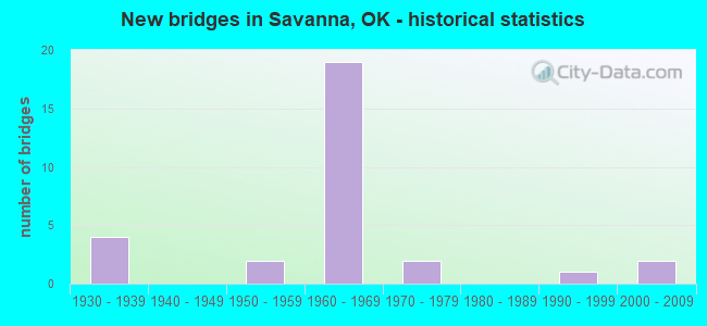
- New bridges - historical statistics
- 41930-1939
- 21950-1959
- 191960-1969
- 21970-1979
- 11990-1999
- 22000-2009

- Reconstructed bridges - Historical Statistics
- 21960-1969
- 11970-1979
- 01980-1989
- 31990-1999
- 12000-2009
- 12010-2019


- Bridge Condition - Deck
- 18.8%Very good
- 50.0%Good
- 25.0%Satisfactory
- 6.3%Fair

- Bridge Condition - Superstructure
- 37.5%Very good
- 18.8%Good
- 37.5%Satisfactory
- 6.3%Fair

- Bridge Condition - Substructure
- 18.8%Very good
- 31.3%Good
- 37.5%Satisfactory
- 12.5%Fair

- Bridge Condition - Channel
- 23.5%Very good
- 17.6%Good
- 41.2%Satisfactory
- 17.6%Fair

- Bridge Condition - Culverts
- 42.9%Very good
- 42.9%Good
- 14.3%Serious
Find on map >> Show street view
Structure Number: 5982, Location: 0.2S & 0.5E TULLAHASSEE (Lat: 35.835983, Lng: -95.431275), Route carried "on" structure: County highway E0814, Year Built: 1938, Status: Posted for load, Structure Length: 0.67m (2.20ft), Average Daily Traffic: 24 (year 2020), Truck Traffic: 10%, Average Future Daily Traffic: 38 (year 2040), Design Load: HS 20, Features Intersected: CREEK
Minimum Vertical Clearance: 30+ m (98+ ft), Kilometerpoint: 0.483, Lanes on structure: 2, Owner: County Highway Agency, Approaching Roadway Width: 7.3m (24.0ft), Material/Design: Concrete, Design/Construction: Slab, Number Of Spans In Main Unit: 2, Length of Maximum Span: 3.0m (9.8ft), Curb-To-Curb Width: 8.5m (27.9ft), Out-to-Out Width: 9.1m (29.9ft)
Condition: Deck: Fair, Superstructure: Satisfactory, Substructure: Satisfactory, Channel: Satisfactory, Operating Rating: 36.3 metric tons, Method Used To Determine Operating Rating: Load Factor (LF), Inventory Rating: 21.6 metric tons, Method Used To Determine Inventory Rating: Load Factor (LF), Structural Evaluation: Equal to present minimum criteria, Deck Geometry: Better than present minimum criteria, Waterway Adequacy: Better than present minimum criteria, Approach Roadway Alignment: Equal to present desirable criteria, Bridge Posting: Required (Relationship of Operating Rating to Maximum Legal Load: 0.1 - 9.9% below), Length Of Structure Improvement: 2.79m (9.15ft), Designated Inspection Frequency: Every 24 months, Inspection Date: August 2020, Bridge Improvement Cost: $143,000, Roadway Improvement Cost: $78,000, Total Project Cost: $225,000 ( Estimate for 2015)
Find on map >> Show street view
Structure Number: 6253, Location: 1. S 2. E OF SAVANNA (Lat: 34.811142, Lng: -95.806739), Route carried "on" structure: County highway E1520, Year Built: 1938, Status: Posted for load, Structure Length: 1.10m (3.61ft), Average Daily Traffic: 100 (year 2020), Truck Traffic: 10%, Average Future Daily Traffic: 160 (year 2040), Design Load: HS 20, Features Intersected: ROCK CREEK
Minimum Vertical Clearance: 30+ m (98+ ft), Kilometerpoint: 0.483, Lanes on structure: 2, Owner: County Highway Agency, Approaching Roadway Width: 6.1m (20.0ft), Material/Design: Concrete, Design/Construction: Slab, Number Of Spans In Main Unit: 3, Length of Maximum Span: 3.0m (9.8ft), Curb-To-Curb Width: 6.1m (20.0ft), Out-to-Out Width: 6.8m (22.3ft)
Condition: Deck: Good, Superstructure: Good, Substructure: Very good, Channel: Satisfactory, Operating Rating: 32.7 metric tons, Method Used To Determine Operating Rating: Load Factor (LF), Inventory Rating: 19.1 metric tons, Method Used To Determine Inventory Rating: Load Factor (LF), Structural Evaluation: Somewhat better than minimum adequacy, Deck Geometry: Somewhat better than minimum adequacy, Waterway Adequacy: Better than present minimum criteria, Approach Roadway Alignment: Equal to present desirable criteria, Length Of Structure Improvement: 3.63m (11.91ft), Designated Inspection Frequency: Every 24 months, Inspection Date: August 2021, Bridge Improvement Cost: $185,000, Roadway Improvement Cost: $102,000, Total Project Cost: $294,000 ( Estimate for 2015), Deck Structure Type: Concrete Cast-file-Place, Wearing Surface/Protective System: Wearing Surface: Monolithic Concrete
Find on map >> Show street view
Structure Number: 6414, Location: 1 S 2 E OF SAVANA (Lat: 34.814514, Lng: -95.811953), Route carried "on" structure: County highway N4050, Year Built: 1938, Year Reconstructed: 1997, Status: Open, Structure Length: 2.41m (7.91ft), Average Daily Traffic: 100 (year 2020), Truck Traffic: 10%, Average Future Daily Traffic: 160 (year 2040), Features Intersected: CHUN CREEK
Minimum Vertical Clearance: 30+ m (98+ ft), Kilometerpoint: 1.127, Lanes on structure: 2, Owner: County Highway Agency, Approaching Roadway Width: 6.1m (20.0ft), Material/Design: Steel, Design/Construction: Stringer/Multi-beam, Number Of Spans In Main Unit: 3, Length of Maximum Span: 8.8m (28.9ft), Curb-To-Curb Width: 5.2m (17.1ft), Out-to-Out Width: 5.2m (17.1ft)
Condition: Deck: Satisfactory, Superstructure: Satisfactory, Substructure: Satisfactory, Channel: Satisfactory, Operating Rating: 63.5 metric tons, Method Used To Determine Operating Rating: Load Factor (LF), Inventory Rating: 38.1 metric tons, Method Used To Determine Inventory Rating: Load Factor (LF), Structural Evaluation: Equal to present minimum criteria, Deck Geometry: High priority of corrective action, Waterway Adequacy: Meets minimum limits, Approach Roadway Alignment: Equal to present desirable criteria, Length Of Structure Improvement: 5.50m (18.04ft), Designated Inspection Frequency: Every 24 months, Inspection Date: August 2021, Bridge Improvement Cost: $281,000, Roadway Improvement Cost: $154,000, Total Project Cost: $448,000 ( Estimate for 2015), Deck Structure Type: Concrete Cast-file-Place, Wearing Surface/Protective System: Wearing Surface: Monolithic Concrete
Find on map >> Show street view
Structure Number: 6707, Location: 4. N OF PITTSBURG (Lat: 34.776325, Lng: -95.847150), Route carried "on" structure: County highway 6160C, Year Built: 1939, Status: Posted for load, Structure Length: 0.67m (2.20ft), Average Daily Traffic: 100 (year 2020), Truck Traffic: 15%, Average Future Daily Traffic: 160 (year 2040), Design Load: HS 20, Features Intersected: CREEK
Minimum Vertical Clearance: 30+ m (98+ ft), Kilometerpoint: 59.533, Lanes on structure: 2, Owner: County Highway Agency, Approaching Roadway Width: 6.7m (22.0ft), Material/Design: Concrete, Design/Construction: Slab, Number Of Spans In Main Unit: 1, Length of Maximum Span: 6.1m (20.0ft), Curb-To-Curb Width: 6.1m (20.0ft), Out-to-Out Width: 6.8m (22.3ft)
Condition: Deck: Satisfactory, Superstructure: Satisfactory, Substructure: Good, Channel: Good, Operating Rating: 32.7 metric tons, Method Used To Determine Operating Rating: Load Factor (LF), Inventory Rating: 19.1 metric tons, Method Used To Determine Inventory Rating: Load Factor (LF), Structural Evaluation: Somewhat better than minimum adequacy, Deck Geometry: Somewhat better than minimum adequacy, Waterway Adequacy: Better than present minimum criteria, Approach Roadway Alignment: Equal to present desirable criteria, Length Of Structure Improvement: 2.79m (9.15ft), Designated Inspection Frequency: Every 24 months, Inspection Date: August 2021, Bridge Improvement Cost: $143,000, Roadway Improvement Cost: $78,000, Total Project Cost: $225,000 ( Estimate for 2015), Deck Structure Type: Concrete Cast-file-Place, Wearing Surface/Protective System: Wearing Surface: Bituminous
Find on map >> Show street view
Structure Number: 11733, Location: 1.8E 2.5N OF SAVANAH (Lat: 34.866022, Lng: -95.807033), Route carried "on" structure: County highway N4050, Year Built: 1997, Status: Posted for load, Structure Length: 0.67m (2.20ft), Average Daily Traffic: 100 (year 2020), Truck Traffic: 10%, Average Future Daily Traffic: 160 (year 2040), Features Intersected: CREEK
Minimum Vertical Clearance: 30+ m (98+ ft), Kilometerpoint: 0.483, Lanes on structure: 2, Owner: County Highway Agency, Approaching Roadway Width: 5.5m (18.0ft), Skew: 1 degrees, Material/Design: Steel, Design/Construction: Culvert, Number Of Spans In Main Unit: 2, Length of Maximum Span: 3.0m (9.8ft), Curb-To-Curb Width: 6.1m (20.0ft), Out-to-Out Width: 6.1m (20.0ft)
Condition: Channel: Good, Culverts: Serious, Operating Rating: 20.9 metric tons, Method Used To Determine Operating Rating: Load Factor (LF), Inventory Rating: 11.8 metric tons, Method Used To Determine Inventory Rating: Load Factor (LF), Structural Evaluation: High priority of corrective action, Deck Geometry: Somewhat better than minimum adequacy, Waterway Adequacy: Equal to present minimum criteria, Approach Roadway Alignment: Better than present minimum criteria, Bridge Posting: Required (Relationship of Operating Rating to Maximum Legal Load: 30.0 - 39.9% below), Length Of Structure Improvement: 2.79m (9.15ft), Designated Inspection Frequency: Every 24 months, Inspection Date: September 2021, Bridge Improvement Cost: $100,000, Roadway Improvement Cost: $75,000, Total Project Cost: $225,000 ( Estimate for 2015)
Find on map >> Show street view
Structure Number: 13605, Location: 5.3 N JCT SH 63 (Lat: 34.792514, Lng: -95.874269), Route carried "on" structure: US 69, Year Built: 1956, Year Reconstructed: 1977, Status: Open, Structure Length: 0.98m (3.22ft), Average Daily Traffic: 16,900 (year 2020), Truck Traffic: 25%, Average Future Daily Traffic: 27,040 (year 2040), Design Load: HS 20, Features Intersected: CREEK
Minimum Vertical Clearance: 30+ m (98+ ft), Kilometerpoint: 13.998, Lanes on structure: 4, Base Highway Network: Yes, Owner: State Highway Agency, Approaching Roadway Width: 23.2m (76.1ft), Skew: 10 degrees, Material/Design: Concrete, Design/Construction: Culvert, Number Of Spans In Main Unit: 3, Length of Maximum Span: 3.0m (9.8ft)
Condition: Channel: Satisfactory, Culverts: Good, Operating Rating: 90.7 metric tons, Method Used To Determine Operating Rating: Load Factor (LF), Inventory Rating: 89.1 metric tons, Method Used To Determine Inventory Rating: Load Factor (LF), Structural Evaluation: Better than present minimum criteria, Waterway Adequacy: Equal to present desirable criteria, Approach Roadway Alignment: Equal to present desirable criteria, Length Of Structure Improvement: 1.04m (3.41ft), Designated Inspection Frequency: Every 24 months, Inspection Date: September 2021, Bridge Improvement Cost: $299,000, Roadway Improvement Cost: $493,000, Total Project Cost: $837,000 ( Estimate for 2015)
Find on map >> Show street view
Structure Number: 13728, Location: 36.82 MI.NE OF TP GATE (Lat: 36.512064, Lng: -95.268514), Route carried "on" structure: Interstate 44, Year Built: 1957, Status: Open, Structure Length: 1.16m (3.81ft), Average Daily Traffic: 15,000 (year 2020), Truck Traffic: 36%, Average Future Daily Traffic: 24,000 (year 2040), Design Load: HS 20, Features Intersected: CRAIG CREEK
Minimum Vertical Clearance: 30+ m (98+ ft), Kilometerpoint: 0.290, Lanes on structure: 4, Base Highway Network: Yes, Toll: On toll road, Owner: State Toll Authority, Approaching Roadway Width: 24.7m (81.0ft), Skew: 30 degrees, Material/Design: Concrete, Design/Construction: Culvert, Number Of Spans In Main Unit: 3, Length of Maximum Span: 3.7m (12.1ft), Curb-To-Curb Width: 34.4m (112.9ft), Out-to-Out Width: 35.1m (115.2ft)
Condition: Channel: Fair, Culverts: Good, Operating Rating: 44.5 metric tons, Method Used To Determine Operating Rating: Load Factor (LF), Inventory Rating: 32.7 metric tons, Method Used To Determine Inventory Rating: Load Factor (LF), Structural Evaluation: Better than present minimum criteria, Deck Geometry: Superior to present desirable criteria, Waterway Adequacy: Equal to present minimum criteria, Approach Roadway Alignment: Equal to present desirable criteria, Length Of Structure Improvement: 3.63m (11.91ft), Designated Inspection Frequency: Every 24 months, Inspection Date: August 2021, Bridge Improvement Cost: $200,000, Roadway Improvement Cost: $150,000, Total Project Cost: $360,000 ( Estimate for 2015)
Find on map >> Show street view
Structure Number: 15949, Location: 10.6 N JCT SH 63 (Lat: 34.858983, Lng: -95.816317), Route carried "on" structure: US 69, Year Built: 1964, Year Reconstructed: 1965, Status: Open, Structure Length: 0.98m (3.22ft), Average Daily Traffic: 20,500 (year 2020), Truck Traffic: 25%, Average Future Daily Traffic: 32,800 (year 2040), Design Load: HS 20, Features Intersected: CREEK
Minimum Vertical Clearance: 30+ m (98+ ft), Kilometerpoint: 23.121, Lanes on structure: 4, Base Highway Network: Yes, Owner: State Highway Agency, Approaching Roadway Width: 14.6m (47.9ft), Skew: 10 degrees, Material/Design: Concrete, Design/Construction: Culvert, Number Of Spans In Main Unit: 3, Length of Maximum Span: 3.0m (9.8ft)
Condition: Channel: Satisfactory, Culverts: Good, Operating Rating: 44.5 metric tons, Method Used To Determine Operating Rating: Load Factor (LF), Inventory Rating: 32.7 metric tons, Method Used To Determine Inventory Rating: Load Factor (LF), Structural Evaluation: Better than present minimum criteria, Waterway Adequacy: Equal to present desirable criteria, Approach Roadway Alignment: Equal to present desirable criteria, Length Of Structure Improvement: 1.01m (3.31ft), Designated Inspection Frequency: Every 24 months, Inspection Date: September 2021, Bridge Improvement Cost: $322,000, Roadway Improvement Cost: $531,000, Total Project Cost: $902,000 ( Estimate for 2015)
Find on map >> Show street view
Structure Number: 16019, Location: 0.2 N INDIAN NATIONS TPK (Lat: 34.864719, Lng: -95.811075), Route carried "on" structure: US 69, Year Built: 1964, Year Reconstructed: 1965, Status: Open, Structure Length: 3.41m (11.19ft), Average Daily Traffic: 10,550 (year 2020), Truck Traffic: 25%, Average Future Daily Traffic: 16,880 (year 2040), Design Load: HS 20, Features Intersected: DANCING RABBIT CREEK
Minimum Vertical Clearance: 30+ m (98+ ft), Kilometerpoint: 23.958, Lanes on structure: 3, Base Highway Network: Yes, Owner: State Highway Agency, Approaching Roadway Width: 10.4m (34.1ft), Skew: 14 degrees, Material/Design: Concrete, Design/Construction: Stringer/Multi-beam, Number Of Spans In Main Unit: 3, Length of Maximum Span: 12.2m (40.0ft), Curb-To-Curb Width: 18.3m (60.0ft), Out-to-Out Width: 19.8m (65.0ft)
Condition: Deck: Satisfactory, Superstructure: Fair, Substructure: Fair, Channel: Satisfactory, Operating Rating: 52.2 metric tons, Method Used To Determine Operating Rating: Load Factor (LF), Inventory Rating: 31.3 metric tons, Method Used To Determine Inventory Rating: Load Factor (LF), Structural Evaluation: Somewhat better than minimum adequacy, Deck Geometry: Superior to present desirable criteria, Waterway Adequacy: Better than present minimum criteria, Approach Roadway Alignment: Equal to present desirable criteria, Length Of Structure Improvement: 6.61m (21.69ft), Designated Inspection Frequency: Every 24 months, Inspection Date: September 2021, Bridge Improvement Cost: $885,000, Roadway Improvement Cost: $1,460,000, Total Project Cost: $2,478,000 ( Estimate for 2015), Deck Structure Type: Concrete Cast-file-Place
Find on map >> Show street view
Structure Number: 16282, Location: 40.3 MI S OF I-40 (Lat: 34.870003, Lng: -95.818836), Route carried "on" structure: Other road , Year Built: 1965, Status: Open, Structure Length: 0.76m (2.49ft), Average Daily Traffic: 8,400 (year 2020), Truck Traffic: 25%, Average Future Daily Traffic: 13,440 (year 2040), Design Load: HS 20, Features Intersected: CREEK, Facility Carried by Structure: IND. NATION TP
Minimum Vertical Clearance: 30+ m (98+ ft), Kilometerpoint: 1.770, Lanes on structure: 4, Base Highway Network: Yes, Toll: On toll road, Owner: State Toll Authority, Approaching Roadway Width: 21.9m (71.9ft), Skew: 20 degrees, Material/Design: Concrete, Design/Construction: Culvert, Number Of Spans In Main Unit: 2, Length of Maximum Span: 3.7m (12.1ft), Curb-To-Curb Width: 56.7m (186.0ft), Out-to-Out Width: 57.3m (188.0ft)
Condition: Channel: Very good, Culverts: Very good, Operating Rating: 44.5 metric tons, Method Used To Determine Operating Rating: Load Factor (LF), Inventory Rating: 32.7 metric tons, Method Used To Determine Inventory Rating: Load Factor (LF), Structural Evaluation: Equal to present desirable criteria, Deck Geometry: Superior to present desirable criteria, Waterway Adequacy: Equal to present desirable criteria, Approach Roadway Alignment: Equal to present desirable criteria, Length Of Structure Improvement: 3.05m (10.01ft), Designated Inspection Frequency: Every 24 months, Inspection Date: June 2021, Bridge Improvement Cost: $200,000, Roadway Improvement Cost: $150,000, Total Project Cost: $360,000 ( Estimate for 2015)
Find on map >> Show street view
Structure Number: 16487, Location: 40.45 MI'S S. JCT I-40 (Lat: 34.869639, Lng: -95.818786), Route carried "on" structure: Other road E1480, Year Built: 1965, Year Reconstructed: 2019, Status: Open, Structure Length: 3.47m (11.38ft), Average Daily Traffic: 8,400 (year 2020), Truck Traffic: 25%, Average Future Daily Traffic: 13,440 (year 2040), Design Load: HS 20, Features Intersected: CO. RD. E1480 UNDER, Facility Carried by Structure: IND. NATION TP
Minimum Vertical Clearance: 30+ m (98+ ft), Kilometerpoint: 1.609, Lanes on structure: 4, Lanes under structure: 2, Base Highway Network: Yes, Toll: On toll road, Owner: State Toll Authority, Approaching Roadway Width: 21.9m (71.9ft), Skew: 22 degrees, Material/Design: Prestressed concrete, Design/Construction: Stringer/Multi-beam, Number Of Spans In Main Unit: 3, Length of Maximum Span: 11.9m (39.0ft), Curb-To-Curb Width: 25.3m (83.0ft), Out-to-Out Width: 26.4m (86.6ft)
Condition: Deck: Very good, Superstructure: Very good, Substructure: Very good, Operating Rating: 73.3 metric tons, Method Used To Determine Operating Rating: Load Factor (LF), Inventory Rating: 43.9 metric tons, Method Used To Determine Inventory Rating: Load Factor (LF), Structural Evaluation: Equal to present desirable criteria, Deck Geometry: Superior to present desirable criteria, Underclear: Meets minimum limits, Approach Roadway Alignment: Equal to present desirable criteria, Length Of Structure Improvement: 3.47m (11.38ft), Designated Inspection Frequency: Every 24 months, Inspection Date: June 2021, Bridge Improvement Cost: $434,000, Roadway Improvement Cost: $651,000, Total Project Cost: $1,248,000 ( Estimate for 2015), Deck Structure Type: Concrete Cast-file-Place, Wearing Surface/Protective System: Wearing Surface: Monolithic Concrete, Deck Protection: Epoxy Coated Reinforcing
Find on map >> Show street view
Structure Number: 16518, Location: 39.41 MI'S S. JCT I-40 (Lat: 34.883889, Lng: -95.821667), Route carried "on" structure: County highway E1470, Year Built: 1965, Status: Open, Structure Length: 4.79m (15.72ft), Average Daily Traffic: 4,860 (year 2020), Truck Traffic: 15%, Average Future Daily Traffic: 7,776 (year 2040), Design Load: H 20, Features Intersected: IND. NATION TP UNDER
Minimum Vertical Clearance: 30+ m (98+ ft), Kilometerpoint: 3.219, Lanes on structure: 2, Lanes under structure: 4, Owner: State Toll Authority, Approaching Roadway Width: 6.4m (21.0ft), Material/Design: Prestressed concrete, Design/Construction: Stringer/Multi-beam, Number Of Spans In Main Unit: 4, Length of Maximum Span: 13.1m (43.0ft), Curb-To-Curb Width: 5.5m (18.0ft), Out-to-Out Width: 7.0m (23.0ft)
Condition: Deck: Good, Superstructure: Very good, Substructure: Satisfactory, Operating Rating: 51.5 metric tons, Method Used To Determine Operating Rating: Load Factor (LF), Inventory Rating: 30.8 metric tons, Method Used To Determine Inventory Rating: Load Factor (LF), Structural Evaluation: Equal to present minimum criteria, Deck Geometry: High priority of replacement, Underclear: Somewhat better than minimum adequacy, Approach Roadway Alignment: Better than present minimum criteria, Length Of Structure Improvement: 4.79m (15.72ft), Designated Inspection Frequency: Every 24 months, Inspection Date: June 2021, Bridge Improvement Cost: $598,000, Roadway Improvement Cost: $897,000, Total Project Cost: $1,713,000 ( Estimate for 2015), Deck Structure Type: Concrete Cast-file-Place, Wearing Surface/Protective System: Wearing Surface: Monolithic Concrete
Find on map >> Show street view
Structure Number: 16592, Location: 41.02 MI S JCT I-40 (Lat: 34.862083, Lng: -95.813058), Route carried "on" structure: Other road , Year Built: 1965, Year Reconstructed: 1990, Status: Open, Structure Length: 5.94m (19.49ft), Average Daily Traffic: 4,200 (year 2020), Truck Traffic: 25%, Average Future Daily Traffic: 6,720 (year 2040), Design Load: HS 20, Features Intersected: U.S. 69 UNDER, Facility Carried by Structure: IND. NATION TP
Minimum Vertical Clearance: 30+ m (98+ ft), Kilometerpoint: 0.000, Lanes on structure: 3, Lanes under structure: 5, Base Highway Network: Yes, Toll: On toll road, Owner: State Toll Authority, Approaching Roadway Width: 11.0m (36.1ft), Skew: 11 degrees, Material/Design: Prestressed concrete, Design/Construction: Stringer/Multi-beam, Number Of Spans In Main Unit: 4, Length of Maximum Span: 19.5m (64.0ft), Curb-To-Curb Width: 11.9m (39.0ft), Out-to-Out Width: 13.4m (44.0ft)
Condition: Deck: Good, Superstructure: Satisfactory, Substructure: Satisfactory, Operating Rating: 44.5 metric tons, Method Used To Determine Operating Rating: Allowable Stress (AS), Inventory Rating: 32.7 metric tons, Method Used To Determine Inventory Rating: Allowable Stress (AS), Structural Evaluation: Equal to present minimum criteria, Deck Geometry: High priority of corrective action, Underclear: Somewhat better than minimum adequacy, Approach Roadway Alignment: Equal to present desirable criteria, Length Of Structure Improvement: 5.94m (19.49ft), Designated Inspection Frequency: Every 24 months, Inspection Date: June 2021, Bridge Improvement Cost: $742,000, Roadway Improvement Cost: $1,113,000, Total Project Cost: $2,122,000 ( Estimate for 2015), Deck Structure Type: Concrete Cast-file-Place, Wearing Surface/Protective System: Wearing Surface: Monolithic Concrete, Deck Protection: Epoxy Coated Reinforcing
Find on map >> Show street view
Structure Number: 16954, Location: 1.0 MI S OF SAVANAH (Lat: 34.816981, Lng: -95.840908), Route carried "on" structure: County highway 6160C, Year Built: 1967, Status: Posted for load, Structure Length: 3.66m (12.01ft), Average Daily Traffic: 100 (year 2020), Truck Traffic: 15%, Average Future Daily Traffic: 160 (year 2040), Design Load: HS 20, Features Intersected: CHUN CREEK
Minimum Vertical Clearance: 30+ m (98+ ft), Kilometerpoint: 11.264, Lanes on structure: 2, Owner: County Highway Agency, Approaching Roadway Width: 7.3m (24.0ft), Material/Design: Concrete, Design/Construction: Stringer/Multi-beam, Number Of Spans In Main Unit: 3, Length of Maximum Span: 12.2m (40.0ft), Curb-To-Curb Width: 8.2m (26.9ft), Out-to-Out Width: 8.7m (28.5ft)
Condition: Deck: Good, Superstructure: Good, Substructure: Fair, Channel: Fair, Operating Rating: 32.7 metric tons, Method Used To Determine Operating Rating: Load Factor (LF), Inventory Rating: 19.1 metric tons, Method Used To Determine Inventory Rating: Load Factor (LF), Structural Evaluation: Somewhat better than minimum adequacy, Deck Geometry: Equal to present minimum criteria, Waterway Adequacy: Better than present minimum criteria, Approach Roadway Alignment: Equal to present desirable criteria, Length Of Structure Improvement: 6.86m (22.51ft), Designated Inspection Frequency: Every 24 months, Inspection Date: August 2021, Bridge Improvement Cost: $351,000, Roadway Improvement Cost: $193,000, Total Project Cost: $560,000 ( Estimate for 2015), Deck Structure Type: Concrete Cast-file-Place, Wearing Surface/Protective System: Wearing Surface: Bituminous
Find on map >> Show street view
Structure Number: 17112, Location: 41.5 MI S OF I-40 (Lat: 34.855761, Lng: -95.807328), Route carried "on" structure: Other road , Year Built: 1968, Status: Open, Structure Length: 0.74m (2.43ft), Average Daily Traffic: 3,800 (year 2020), Truck Traffic: 25%, Average Future Daily Traffic: 6,080 (year 2040), Design Load: HS 20, Features Intersected: CREEK, Facility Carried by Structure: IND. NATION TP
Minimum Vertical Clearance: 30+ m (98+ ft), Kilometerpoint: 30.571, Lanes on structure: 4, Base Highway Network: Yes, Toll: On toll road, Owner: State Toll Authority, Approaching Roadway Width: 21.9m (71.9ft), Skew: 23 degrees, Material/Design: Concrete, Design/Construction: Culvert, Number Of Spans In Main Unit: 2, Length of Maximum Span: 3.0m (9.8ft), Curb-To-Curb Width: 54.3m (178.1ft), Out-to-Out Width: 54.9m (180.1ft)
Condition: Channel: Good, Culverts: Very good, Operating Rating: 44.5 metric tons, Method Used To Determine Operating Rating: Load Factor (LF), Inventory Rating: 32.7 metric tons, Method Used To Determine Inventory Rating: Load Factor (LF), Structural Evaluation: Equal to present desirable criteria, Deck Geometry: Superior to present desirable criteria, Waterway Adequacy: Equal to present desirable criteria, Approach Roadway Alignment: Equal to present desirable criteria, Length Of Structure Improvement: 2.72m (8.92ft), Designated Inspection Frequency: Every 24 months, Inspection Date: June 2021, Bridge Improvement Cost: $200,000, Roadway Improvement Cost: $150,000, Total Project Cost: $360,000 ( Estimate for 2015)
Find on map >> Show street view
Structure Number: 1726, Location: 42.79 MI'S S. JCT I-40 (Lat: 34.840278, Lng: -95.799444), Route carried "on" structure: County highway 6184C, Year Built: 1968, Status: Open, Structure Length: 4.82m (15.81ft), Average Daily Traffic: 100 (year 2020), Truck Traffic: 15%, Average Future Daily Traffic: 160 (year 2040), Design Load: H 15, Features Intersected: IND. NATION TP UNDER
Minimum Vertical Clearance: 30+ m (98+ ft), Kilometerpoint: 28.801, Lanes on structure: 2, Lanes under structure: 4, Owner: State Toll Authority, Approaching Roadway Width: 6.4m (21.0ft), Skew: 1 degrees, Material/Design: Prestressed concrete, Design/Construction: Stringer/Multi-beam, Number Of Spans In Main Unit: 2, Length of Maximum Span: 24.1m (79.1ft), Curb-To-Curb Width: 5.5m (18.0ft), Out-to-Out Width: 7.0m (23.0ft)
Condition: Deck: Good, Superstructure: Very good, Substructure: Good, Operating Rating: 88.9 metric tons, Method Used To Determine Operating Rating: Load Factor (LF), Inventory Rating: 54.4 metric tons, Method Used To Determine Inventory Rating: Load Factor (LF), Structural Evaluation: Better than present minimum criteria, Deck Geometry: Meets minimum limits, Underclear: Equal to present minimum criteria, Approach Roadway Alignment: Somewhat better than minimum adequacy, Length Of Structure Improvement: 4.82m (15.81ft), Designated Inspection Frequency: Every 24 months, Inspection Date: June 2021, Bridge Improvement Cost: $603,000, Roadway Improvement Cost: $905,000, Total Project Cost: $1,728,000 ( Estimate for 2015), Deck Structure Type: Concrete Cast-file-Place, Wearing Surface/Protective System: Wearing Surface: Monolithic Concrete
Find on map >> Show street view
Structure Number: 17465, Location: 0.2 N INDIAN NATIONS TPK (Lat: 34.864767, Lng: -95.810369), Route carried "on" structure: US 69, Year Built: 1969, Status: Open, Structure Length: 3.63m (11.91ft), Average Daily Traffic: 10,650 (year 2020), Truck Traffic: 25%, Average Future Daily Traffic: 17,040 (year 2040), Design Load: HS 20, Features Intersected: DANCING RABBIT CREEK
Minimum Vertical Clearance: 30+ m (98+ ft), Kilometerpoint: 23.958, Lanes on structure: 3, Base Highway Network: Yes, Owner: State Highway Agency, Approaching Roadway Width: 10.4m (34.1ft), Skew: 14 degrees, Material/Design: Prestressed concrete, Design/Construction: Stringer/Multi-beam, Number Of Spans In Main Unit: 3, Length of Maximum Span: 12.2m (40.0ft), Curb-To-Curb Width: 15.7m (51.5ft), Out-to-Out Width: 16.2m (53.1ft)
Condition: Deck: Satisfactory, Superstructure: Satisfactory, Substructure: Satisfactory, Channel: Fair, Operating Rating: 44.2 metric tons, Method Used To Determine Operating Rating: Allowable Stress (AS), Inventory Rating: 32.5 metric tons, Method Used To Determine Inventory Rating: Allowable Stress (AS), Structural Evaluation: Equal to present minimum criteria, Deck Geometry: Better than present minimum criteria, Waterway Adequacy: Better than present minimum criteria, Approach Roadway Alignment: Equal to present desirable criteria, Length Of Structure Improvement: 6.83m (22.41ft), Designated Inspection Frequency: Every 24 months, Inspection Date: September 2021, Bridge Improvement Cost: $770,000, Roadway Improvement Cost: $1,271,000, Total Project Cost: $2,157,000 ( Estimate for 2015), Deck Structure Type: Concrete Cast-file-Place, Wearing Surface/Protective System: Wearing Surface: Monolithic Concrete
Find on map >> Show street view
Structure Number: 17519, Location: 44.88 MI'S S. JCT I-40 (Lat: 34.811111, Lng: -95.789444), Route carried "on" structure: County highway E1520, Year Built: 1969, Status: Open, Structure Length: 5.43m (17.81ft), Average Daily Traffic: 2,500 (year 2020), Truck Traffic: 15%, Average Future Daily Traffic: 4,000 (year 2040), Design Load: HS 20, Features Intersected: IND. NATION TP UNDER
Minimum Vertical Clearance: 30+ m (98+ ft), Kilometerpoint: 25.421, Lanes on structure: 2, Lanes under structure: 4, Owner: State Toll Authority, Approaching Roadway Width: 6.4m (21.0ft), Skew: 2 degrees, Material/Design: Prestressed concrete, Design/Construction: Stringer/Multi-beam, Number Of Spans In Main Unit: 2, Length of Maximum Span: 28.0m (91.9ft), Curb-To-Curb Width: 5.5m (18.0ft), Out-to-Out Width: 7.0m (23.0ft)
Condition: Deck: Good, Superstructure: Very good, Substructure: Good, Operating Rating: 88.9 metric tons, Method Used To Determine Operating Rating: Load Factor (LF), Inventory Rating: 60.8 metric tons, Method Used To Determine Inventory Rating: Load Factor (LF), Structural Evaluation: Better than present minimum criteria, Deck Geometry: High priority of replacement, Underclear: Equal to present minimum criteria, Approach Roadway Alignment: Somewhat better than minimum adequacy, Length Of Structure Improvement: 5.43m (17.81ft), Designated Inspection Frequency: Every 24 months, Inspection Date: June 2021, Bridge Improvement Cost: $679,000, Roadway Improvement Cost: $1,019,000, Total Project Cost: $1,943,000 ( Estimate for 2015), Deck Structure Type: Concrete Cast-file-Place, Wearing Surface/Protective System: Wearing Surface: Monolithic Concrete
Find on map >> Show street view
Structure Number: 17539, Location: 41.02 MI S JCT I-40 (Lat: 34.862378, Lng: -95.812947), Route carried "on" structure: Other road , Year Built: 1965, Year Reconstructed: 1990, Status: Open, Structure Length: 5.94m (19.49ft), Average Daily Traffic: 4,050 (year 2020), Truck Traffic: 25%, Average Future Daily Traffic: 6,480 (year 2040), Design Load: HS 20, Features Intersected: U.S. 69 UNDER, Facility Carried by Structure: IND. NATION TP
Minimum Vertical Clearance: 30+ m (98+ ft), Kilometerpoint: 0.000, Lanes on structure: 3, Lanes under structure: 5, Base Highway Network: Yes, Toll: On toll road, Owner: State Toll Authority, Approaching Roadway Width: 11.0m (36.1ft), Skew: 11 degrees, Material/Design: Prestressed concrete, Design/Construction: Stringer/Multi-beam, Number Of Spans In Main Unit: 4, Length of Maximum Span: 19.5m (64.0ft), Curb-To-Curb Width: 11.9m (39.0ft), Out-to-Out Width: 13.4m (44.0ft)
Condition: Deck: Good, Superstructure: Satisfactory, Substructure: Satisfactory, Channel: Satisfactory, Operating Rating: 44.5 metric tons, Method Used To Determine Operating Rating: Allowable Stress (AS), Inventory Rating: 32.7 metric tons, Method Used To Determine Inventory Rating: Allowable Stress (AS), Structural Evaluation: Equal to present minimum criteria, Deck Geometry: High priority of corrective action, Underclear: Somewhat better than minimum adequacy, Approach Roadway Alignment: Equal to present desirable criteria, Length Of Structure Improvement: 5.94m (19.49ft), Designated Inspection Frequency: Every 24 months, Inspection Date: June 2021, Bridge Improvement Cost: $742,000, Roadway Improvement Cost: $1,113,000, Total Project Cost: $2,122,000 ( Estimate for 2015), Deck Structure Type: Concrete Cast-file-Place, Wearing Surface/Protective System: Wearing Surface: Monolithic Concrete, Deck Protection: Epoxy Coated Reinforcing
Find on map >> Show street view
Structure Number: 1757, Location: 44.14 MI'S S. JCT I-40 (Lat: 34.823278, Lng: -95.795133), Route carried "on" structure: Other road , Year Built: 1969, Year Reconstructed: 2013, Status: Open, Structure Length: 9.24m (30.31ft), Average Daily Traffic: 3,800 (year 2020), Truck Traffic: 25%, Average Future Daily Traffic: 6,080 (year 2040), Design Load: HS 20, Features Intersected: PEACEABLE CREEK, Facility Carried by Structure: IND. NATION TP
Minimum Vertical Clearance: 30+ m (98+ ft), Kilometerpoint: 27.031, Lanes on structure: 4, Base Highway Network: Yes, Toll: On toll road, Owner: State Toll Authority, Approaching Roadway Width: 21.9m (71.9ft), Skew: 32 degrees, Material/Design: Prestressed concrete, Design/Construction: Stringer/Multi-beam, Number Of Spans In Main Unit: 3, Length of Maximum Span: 30.5m (100.1ft), Curb-To-Curb Width: 21.0m (68.9ft), Out-to-Out Width: 22.6m (74.1ft)
Condition: Deck: Very good, Superstructure: Very good, Substructure: Good, Channel: Very good, Operating Rating: 44.5 metric tons, Method Used To Determine Operating Rating: Allowable Stress (AS), Inventory Rating: 32.7 metric tons, Method Used To Determine Inventory Rating: Allowable Stress (AS), Structural Evaluation: Better than present minimum criteria, Deck Geometry: Superior to present desirable criteria, Waterway Adequacy: Equal to present desirable criteria, Approach Roadway Alignment: Equal to present desirable criteria, Length Of Structure Improvement: 11.21m (36.78ft), Designated Inspection Frequency: Every 24 months, Inspection Date: June 2021, Bridge Improvement Cost: $1,401,000, Roadway Improvement Cost: $2,102,000, Total Project Cost: $3,992,000 ( Estimate for 2015), Deck Structure Type: Concrete Cast-file-Place, Wearing Surface/Protective System: Wearing Surface: Monolithic Concrete, Deck Protection: Epoxy Coated Reinforcing
Find on map >> Show street view
Structure Number: 19037, Location: 12.38 N ATOKA C/L (Lat: 34.835833, Lng: -95.836944), Route carried "on" structure: County highway , Year Built: 1975, Status: Open, Structure Length: 3.47m (11.38ft), Average Daily Traffic: 100 (year 2020), Truck Traffic: 16%, Average Future Daily Traffic: 160 (year 2040), Design Load: HS 20, Features Intersected: U.S. 69 UNDER, Facility Carried by Structure: NAVAL RD
Minimum Vertical Clearance: 30+ m (98+ ft), Kilometerpoint: 19.919, Lanes on structure: 2, Lanes under structure: 5, Owner: State Highway Agency, Approaching Roadway Width: 15.2m (49.9ft), Material/Design: Steel, Design/Construction: Stringer/Multi-beam, Number Of Spans In Main Unit: 1, Length of Maximum Span: 33.2m (108.9ft), Curb or Sidewalk Widths: Left: 1.2m (3.9ft), Right: 1.2m (3.9ft), Curb-To-Curb Width: 15.2m (49.9ft), Out-to-Out Width: 18.3m (60.0ft)
Condition: Deck: Good, Superstructure: Good, Substructure: Good, Operating Rating: 54.4 metric tons, Method Used To Determine Operating Rating: Load Factor (LF), Inventory Rating: 32.7 metric tons, Method Used To Determine Inventory Rating: Load Factor (LF), Structural Evaluation: Better than present minimum criteria, Deck Geometry: Superior to present desirable criteria, Underclear: Equal to present minimum criteria, Approach Roadway Alignment: Equal to present desirable criteria, Length Of Structure Improvement: 8.40m (27.56ft), Designated Inspection Frequency: Every 24 months, Inspection Date: September 2021, Bridge Improvement Cost: $1,087,000, Roadway Improvement Cost: $1,794,000, Total Project Cost: $3,044,000 ( Estimate for 2015), Deck Structure Type: Concrete Cast-file-Place, Wearing Surface/Protective System: Wearing Surface: Bituminous
Find on map >> Show street view
Structure Number: 28378, Location: 2.3MI.S OF SAVANNA (Lat: 34.790772, Lng: -95.840808), Route carried "on" structure: County highway D4030, Year Built: 2006, Status: Open, Structure Length: 1.54m (5.05ft), Average Daily Traffic: 100 (year 2020), Truck Traffic: 10%, Average Future Daily Traffic: 160 (year 2040), Design Load: HS 20, Features Intersected: CHUN CREEK
Minimum Vertical Clearance: 30+ m (98+ ft), Kilometerpoint: 0.483, Lanes on structure: 2, Owner: County Highway Agency, Approaching Roadway Width: 7.3m (24.0ft), Material/Design: Prestressed concrete, Design/Construction: Tee Beam, Number Of Spans In Main Unit: 1, Length of Maximum Span: 14.2m (46.6ft), Curb-To-Curb Width: 8.0m (26.2ft), Out-to-Out Width: 8.5m (27.9ft)
Condition: Deck: Very good, Superstructure: Very good, Substructure: Very good, Channel: Very good, Operating Rating: 52.6 metric tons, Method Used To Determine Operating Rating: Load Factor (LF), Inventory Rating: 32.7 metric tons, Method Used To Determine Inventory Rating: Load Factor (LF), Structural Evaluation: Equal to present desirable criteria, Deck Geometry: Equal to present minimum criteria, Waterway Adequacy: Equal to present desirable criteria, Approach Roadway Alignment: Equal to present minimum criteria, Length Of Structure Improvement: 1.69m (5.54ft), Designated Inspection Frequency: Every 24 months, Inspection Date: August 2021, Bridge Improvement Cost: $184,000, Roadway Improvement Cost: $92,000, Total Project Cost: $294,000 ( Estimate for 2015), Deck Structure Type: Concrete Cast-file-Place, Wearing Surface/Protective System: Wearing Surface: Monolithic Concrete
Find on map >> Show street view
Structure Number: 28708, Location: 40.83 M S. JCT I-40 (Lat: 34.865756, Lng: -95.815714), Route carried "on" structure: Other road , Year Built: 2006, Status: Open, Structure Length: 1.23m (4.04ft), Average Daily Traffic: 8,400 (year 2020), Truck Traffic: 25%, Average Future Daily Traffic: 13,440 (year 2040), Design Load: HS 20, Features Intersected: DANCING RABBIT CREEK, Facility Carried by Structure: IND. NATION TP
Minimum Vertical Clearance: 30+ m (98+ ft), Kilometerpoint: 1.553, Lanes on structure: 6, Base Highway Network: Yes, Toll: On toll road, Owner: State Toll Authority, Approaching Roadway Width: 26.5m (86.9ft), Skew: 20 degrees, Material/Design: Concrete, Design/Construction: Culvert, Number Of Spans In Main Unit: 3, Length of Maximum Span: 4.3m (14.1ft), Curb-To-Curb Width: 90.8m (297.9ft), Out-to-Out Width: 91.4m (299.9ft)
Condition: Channel: Very good, Culverts: Very good, Operating Rating: 44.5 metric tons, Method Used To Determine Operating Rating: Load Factor (LF), Inventory Rating: 32.7 metric tons, Method Used To Determine Inventory Rating: Load Factor (LF), Structural Evaluation: Equal to present desirable criteria, Deck Geometry: Superior to present desirable criteria, Waterway Adequacy: Superior to present desirable criteria, Approach Roadway Alignment: Equal to present desirable criteria, Length Of Structure Improvement: 1.68m (5.51ft), Designated Inspection Frequency: Every 24 months, Inspection Date: June 2021, Bridge Improvement Cost: $230,000, Roadway Improvement Cost: $380,000, Total Project Cost: $644,000 ( Estimate for 2015)
Find on map >> Show street view
Structure Number: 16487, Location: 40.45 MI'S S. JCT I-40 (Lat: 34.869639, Lng: -95.818786), Route carried "under" structure: County highway 6186C, Year Built: 1965, Structure Length: 0. m, Average Daily Traffic: 300 (year 2020), Truck Traffic: 15%, Features Intersected: CO. RD. E1480 UNDER, Facility Carried by Structure: IND. NATION TP
Minimum Vertical Clearance: 4.83m (15.85ft), Kilometerpoint: 1.609, Lanes on structure: 4, Lanes under structure: 2, Material/Design: Prestressed concrete, Design/Construction: Stringer/Multi-beam, Length of Maximum Span: 11.9m (39.0ft)
Find on map >> Show street view
Structure Number: 16518, Location: 39.41 MI'S S. JCT I-40 (Lat: 34.883889, Lng: -95.821667), Route carried "under" structure: Other road , Year Built: 1965, Structure Length: 0. m, Average Daily Traffic: 8,400 (year 2020), Truck Traffic: 25%, Features Intersected: IND. NATION TP UNDER, Facility Carried by Structure: CO. RD. E1470
Minimum Vertical Clearance: 5.64m (18.50ft), Kilometerpoint: 3.219, Lanes on structure: 2, Lanes under structure: 4, Toll: On toll road, Material/Design: Prestressed concrete, Design/Construction: Stringer/Multi-beam, Length of Maximum Span: 13.1m (43.0ft)
Find on map >> Show street view
Structure Number: 16592, Location: 41.02 MI S JCT I-40 (Lat: 34.862083, Lng: -95.813058), Route carried "under" structure: US 69, Year Built: 1965, Structure Length: 0. m, Average Daily Traffic: 20,500 (year 2020), Truck Traffic: 25%, Features Intersected: U.S. 69 UNDER, Facility Carried by Structure: IND. NATION TP
Minimum Vertical Clearance: 5.26m (17.26ft), Kilometerpoint: 23.604, Lanes on structure: 3, Lanes under structure: 5, Material/Design: Prestressed concrete, Design/Construction: Stringer/Multi-beam, Length of Maximum Span: 19.5m (64.0ft)
Find on map >> Show street view
Structure Number: 1726, Location: 42.79 MI'S S. JCT I-40 (Lat: 34.840278, Lng: -95.799444), Route carried "under" structure: Other road , Year Built: 1968, Structure Length: 0. m, Average Daily Traffic: 3,800 (year 2020), Truck Traffic: 25%, Features Intersected: IND. NATION TP UNDER, Facility Carried by Structure: CO. RD. 6184C
Minimum Vertical Clearance: 5.13m (16.83ft), Kilometerpoint: 28.801, Lanes on structure: 2, Lanes under structure: 4, Toll: On toll road, Material/Design: Prestressed concrete, Design/Construction: Stringer/Multi-beam, Length of Maximum Span: 24.1m (79.1ft)
Find on map >> Show street view
Structure Number: 17519, Location: 44.88 MI'S S. JCT I-40 (Lat: 34.811111, Lng: -95.789444), Route carried "under" structure: Other road , Year Built: 1969, Structure Length: 0. m, Average Daily Traffic: 3,800 (year 2020), Truck Traffic: 25%, Features Intersected: IND. NATION TP UNDER, Facility Carried by Structure: CO. RD. E1520
Minimum Vertical Clearance: 5.03m (16.50ft), Kilometerpoint: 25.421, Lanes on structure: 2, Lanes under structure: 4, Toll: On toll road, Material/Design: Prestressed concrete, Design/Construction: Stringer/Multi-beam, Length of Maximum Span: 28.0m (91.9ft)
Find on map >> Show street view
Structure Number: 17539, Location: 41.02 MI S JCT I-40 (Lat: 34.862378, Lng: -95.812947), Route carried "under" structure: US 69, Year Built: 1965, Structure Length: 0. m, Average Daily Traffic: 20,500 (year 2020), Truck Traffic: 25%, Features Intersected: U.S. 69 UNDER, Facility Carried by Structure: IND. NATION TP
Minimum Vertical Clearance: 5.18m (16.99ft), Kilometerpoint: 23.572, Lanes on structure: 3, Lanes under structure: 5, Material/Design: Prestressed concrete, Design/Construction: Stringer/Multi-beam, Length of Maximum Span: 19.5m (64.0ft)
Find on map >> Show street view
Structure Number: 19037, Location: 12.38 N ATOKA C/L (Lat: 34.835833, Lng: -95.836944), Route carried "under" structure: US 69, Year Built: 1975, Structure Length: 0. m, Average Daily Traffic: 18,300 (year 2020), Truck Traffic: 25%, Features Intersected: U.S. 69 UNDER, Facility Carried by Structure: NAVAL RD
Minimum Vertical Clearance: 5.08m (16.67ft), Kilometerpoint: 19.919, Lanes on structure: 2, Lanes under structure: 5, Material/Design: Steel, Design/Construction: Stringer/Multi-beam, Length of Maximum Span: 33.2m (108.9ft)