Bridge Statistics for Savannah, Georgia (GA)
Condition, Traffic, Stress, Structural Evaluation, Project Costs
- National Bridge Inventory (NBI) Statistics
- 244Number of bridges
- 7,267ft / 2,215mTotal length
- $3,744,464,000Total costs
- 4,936,686Total average daily traffic
- 135,615Total average daily truck traffic
- National Bridge Inventory (NBI) Registered Bridges for Savannah
- No street view available for this location
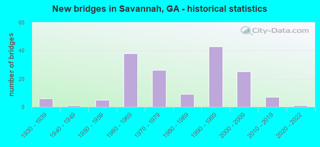
- New bridges - historical statistics
- 61930-1939
- 11940-1949
- 51950-1959
- 381960-1969
- 261970-1979
- 91980-1989
- 431990-1999
- 252000-2009
- 72010-2019
- 12020-2022

- Reconstructed bridges - Historical Statistics
- 41970-1979
- 71980-1989
- 121990-1999


- Bridge Condition - Deck
- 10.7%Very good
- 77.9%Good
- 11.4%Satisfactory

- Bridge Condition - Superstructure
- 29.3%Very good
- 65.0%Good
- 4.3%Satisfactory
- 1.4%Fair

- Bridge Condition - Substructure
- 6.4%Very good
- 87.1%Good
- 5.0%Satisfactory
- 1.4%Fair

- Bridge Condition - Channel
- 2.4%Excellent
- 64.6%Very good
- 29.3%Good
- 1.2%Satisfactory
- 2.4%Fair

- Bridge Condition - Culverts
- 23.8%Very good
- 57.1%Good
- 9.5%Satisfactory
- 4.8%Fair
- 4.8%Poor
Find on map >> Show street view
Structure Number: 290005, Location: 2.9 MILES NORTH OF RICHMO (Lat: 31.978289, Lng: -81.289317), Route carried "on" structure: US 17, Year Built: 1958, Year Reconstructed: 1998, Status: Open, Structure Length: 24.44m (80.18ft), Average Daily Traffic: 23,260 (year 2012), Truck Traffic: 1%, Average Future Daily Traffic: 34,890 (year 2032), Design Load: HS 20+Mod, Features Intersected: OGEECHEE RIVER
Minimum Vertical Clearance: 30+ m (98+ ft), Kilometerpoint: 14.484, Lanes on structure: 4, Base Highway Network: Yes, Owner: State Highway Agency, Approaching Roadway Width: 18.3m (60.0ft), Skew: 10 degrees, Material/Design: Steel continuous, Design/Construction: Stringer/Multi-beam, Number Of Spans In Main Unit: 4, Number Of Approach Spans: 12, Length of Maximum Span: 33.2m (108.9ft), Curb-To-Curb Width: 21.9m (71.9ft), Out-to-Out Width: 27.8m (91.2ft)
Condition: Deck: Good, Superstructure: Good, Substructure: Satisfactory, Channel: Good, Operating Rating: 34.4 metric tons, Method Used To Determine Operating Rating: Load Factor (LF), Inventory Rating: 20.8 metric tons, Method Used To Determine Inventory Rating: Load Factor (LF), Structural Evaluation: Somewhat better than minimum adequacy, Deck Geometry: Superior to present desirable criteria, Waterway Adequacy: Equal to present desirable criteria, Approach Roadway Alignment: Equal to present desirable criteria, Designated Inspection Frequency: Every 24 months, Underwater Inspection Frequency: Every 60 months, Inspection Date: September 2021, Underwater Inspection Date: October 2020, Deck Structure Type: Concrete Cast-file-Place, Wearing Surface/Protective System: Wearing Surface: Epoxy Overlay
Find on map >> Show street view
Structure Number: 290024, Location: 4.4 MILES S OF MELDRIM (Lat: 32.079519, Lng: -81.384739), Route carried "on" structure: State highway 204, Year Built: 1975, Status: Open, Structure Length: 21.79m (71.49ft), Average Daily Traffic: 3,060 (year 2012), Truck Traffic: 1%, Average Future Daily Traffic: 4,590 (year 2032), Design Load: HS 15, Features Intersected: OGEECHEE RIVER, Facility Carried by Structure: J.O.BACON HIGHWAY
Minimum Vertical Clearance: 30+ m (98+ ft), Kilometerpoint: 19.312, Lanes on structure: 2, Base Highway Network: Yes, Owner: State Highway Agency, Approaching Roadway Width: 7.9m (25.9ft), Skew: 2 degrees, Material/Design: Prestressed concrete, Design/Construction: Stringer/Multi-beam, Number Of Spans In Main Unit: 5, Number Of Approach Spans: 10, Length of Maximum Span: 22.9m (75.1ft), Curb or Sidewalk Widths: Left: 0.2m (0.7ft), Right: 0.2m (0.7ft), Curb-To-Curb Width: 9.4m (30.8ft), Out-to-Out Width: 10.5m (34.4ft)
Condition: Deck: Good, Superstructure: Good, Substructure: Good, Channel: Very good, Operating Rating: 34.4 metric tons, Method Used To Determine Operating Rating: Load Factor (LF), Inventory Rating: 20.8 metric tons, Method Used To Determine Inventory Rating: Load Factor (LF), Structural Evaluation: Somewhat better than minimum adequacy, Deck Geometry: Meets minimum limits, Waterway Adequacy: Equal to present desirable criteria, Approach Roadway Alignment: Equal to present desirable criteria, Designated Inspection Frequency: Every 24 months, Underwater Inspection Frequency: Every 60 months, Inspection Date: September 2021, Underwater Inspection Date: October 2020, Bridge Improvement Cost: $1,000, Roadway Improvement Cost: $2,000, Total Project Cost: $3,000, Deck Structure Type: Concrete Cast-file-Place
Find on map >> Show street view
Structure Number: 290033, Location: 1.7 MILES W OF MELDRIM (Lat: 32.137628, Lng: -81.406969), Route carried "on" structure: Interstate 16, Year Built: 1966, Year Reconstructed: 2004, Status: Open, Structure Length: 19.32m (63.39ft), Average Daily Traffic: 26,240 (year 2012), Truck Traffic: 1%, Average Future Daily Traffic: 39,360 (year 2032), Design Load: HS 20+Mod, Features Intersected: OGEECHEE RIVER
Minimum Vertical Clearance: 30+ m (98+ ft), Kilometerpoint: 236.574, Lanes on structure: 2, Base Highway Network: Yes, Owner: State Highway Agency, Approaching Roadway Width: 11.6m (38.1ft), Skew: 10 degrees, Material/Design: Prestressed concrete, Design/Construction: Stringer/Multi-beam, Number Of Spans In Main Unit: 3, Number Of Approach Spans: 10, Length of Maximum Span: 23.8m (78.1ft), Curb-To-Curb Width: 12.8m (42.0ft), Out-to-Out Width: 13.8m (45.3ft)
Condition: Deck: Satisfactory, Superstructure: Satisfactory, Substructure: Satisfactory, Channel: Very good, Operating Rating: 49.8 metric tons, Method Used To Determine Operating Rating: Load Factor (LF), Inventory Rating: 24.4 metric tons, Method Used To Determine Inventory Rating: Load Factor (LF), Structural Evaluation: Equal to present minimum criteria, Deck Geometry: Equal to present desirable criteria, Waterway Adequacy: Equal to present desirable criteria, Approach Roadway Alignment: Equal to present desirable criteria, Length Of Structure Improvement: 25.76m (84.51ft), Designated Inspection Frequency: Every 24 months, Underwater Inspection Frequency: Every 60 months, Inspection Date: September 2021, Underwater Inspection Date: October 2020, Bridge Improvement Cost: $366,000, Roadway Improvement Cost: $79,000, Total Project Cost: $698,000, Deck Structure Type: Concrete Cast-file-Place
Find on map >> Show street view
Structure Number: 290034, Location: 1.7 MILES W OF MELDRIM (Lat: 32.137769, Lng: -81.406608), Route carried "on" structure: Interstate 16, Year Built: 1966, Year Reconstructed: 2004, Status: Open, Structure Length: 19.32m (63.39ft), Average Daily Traffic: 26,240 (year 2012), Truck Traffic: 1%, Average Future Daily Traffic: 39,360 (year 2032), Design Load: HS 20+Mod, Features Intersected: OGEECHEE RIVER
Minimum Vertical Clearance: 30+ m (98+ ft), Kilometerpoint: 236.574, Lanes on structure: 2, Base Highway Network: Yes, Owner: State Highway Agency, Approaching Roadway Width: 11.6m (38.1ft), Skew: 10 degrees, Material/Design: Prestressed concrete, Design/Construction: Stringer/Multi-beam, Number Of Spans In Main Unit: 3, Number Of Approach Spans: 10, Length of Maximum Span: 23.8m (78.1ft), Curb-To-Curb Width: 12.8m (42.0ft), Out-to-Out Width: 13.8m (45.3ft)
Condition: Deck: Good, Superstructure: Satisfactory, Substructure: Good, Channel: Good, Operating Rating: 49.8 metric tons, Method Used To Determine Operating Rating: Load Factor (LF), Inventory Rating: 29.9 metric tons, Method Used To Determine Inventory Rating: Load Factor (LF), Structural Evaluation: Equal to present minimum criteria, Deck Geometry: Equal to present desirable criteria, Waterway Adequacy: Equal to present desirable criteria, Approach Roadway Alignment: Equal to present desirable criteria, Length Of Structure Improvement: 25.76m (84.51ft), Designated Inspection Frequency: Every 24 months, Underwater Inspection Frequency: Every 60 months, Inspection Date: September 2021, Underwater Inspection Date: October 2020, Bridge Improvement Cost: $572,000, Roadway Improvement Cost: $83,000, Total Project Cost: $930,000, Deck Structure Type: Concrete Cast-file-Place
Find on map >> Show street view
Structure Number: 290047, Location: 3 MILES NORTH OF RICHMOND (Lat: 31.980669, Lng: -81.307839), Route carried "on" structure: Interstate 95, Year Built: 1969, Year Reconstructed: 1996, Status: Open, Structure Length: 43.89m (144.00ft), Average Daily Traffic: 67,950 (year 2012), Truck Traffic: 1%, Average Future Daily Traffic: 101,925 (year 2032), Design Load: HS 20+Mod, Features Intersected: OGEECHEE RIVER
Minimum Vertical Clearance: 30+ m (98+ ft), Kilometerpoint: 146.450, Lanes on structure: 3, Base Highway Network: Yes, Owner: State Highway Agency, Approaching Roadway Width: 18.9m (62.0ft), Skew: 10 degrees, Material/Design: Steel continuous, Design/Construction: Stringer/Multi-beam, Number Of Spans In Main Unit: 4, Number Of Approach Spans: 24, Length of Maximum Span: 41.1m (134.8ft), Curb-To-Curb Width: 23.3m (76.4ft), Out-to-Out Width: 24.2m (79.4ft)
Condition: Deck: Good, Superstructure: Good, Substructure: Good, Channel: Very good, Operating Rating: 34.4 metric tons, Method Used To Determine Operating Rating: Load Factor (LF), Inventory Rating: 20.8 metric tons, Method Used To Determine Inventory Rating: Load Factor (LF), Structural Evaluation: Somewhat better than minimum adequacy, Deck Geometry: Superior to present desirable criteria, Waterway Adequacy: Equal to present desirable criteria, Approach Roadway Alignment: Equal to present desirable criteria, Designated Inspection Frequency: Every 24 months, Underwater Inspection Frequency: Every 60 months, Inspection Date: December 2021, Underwater Inspection Date: October 2020, Deck Structure Type: Concrete Cast-file-Place
Find on map >> Show street view
Structure Number: 290048, Location: 3 MILES NORTH OF RICHMOND (Lat: 31.980850, Lng: -81.307939), Route carried "on" structure: Interstate 95, Year Built: 1969, Year Reconstructed: 1996, Status: Open, Structure Length: 43.89m (144.00ft), Average Daily Traffic: 67,950 (year 2012), Truck Traffic: 1%, Average Future Daily Traffic: 101,925 (year 2032), Design Load: HS 20+Mod, Features Intersected: OGEECHEE RIVER
Minimum Vertical Clearance: 30+ m (98+ ft), Kilometerpoint: 146.450, Lanes on structure: 3, Base Highway Network: Yes, Owner: State Highway Agency, Approaching Roadway Width: 18.3m (60.0ft), Skew: 10 degrees, Material/Design: Steel continuous, Design/Construction: Stringer/Multi-beam, Number Of Spans In Main Unit: 4, Number Of Approach Spans: 24, Length of Maximum Span: 41.1m (134.8ft), Curb-To-Curb Width: 23.0m (75.5ft), Out-to-Out Width: 24.2m (79.4ft)
Condition: Deck: Satisfactory, Superstructure: Good, Substructure: Good, Channel: Very good, Operating Rating: 42.6 metric tons, Method Used To Determine Operating Rating: Load Factor (LF), Inventory Rating: 25.4 metric tons, Method Used To Determine Inventory Rating: Load Factor (LF), Structural Evaluation: Equal to present minimum criteria, Deck Geometry: Superior to present desirable criteria, Waterway Adequacy: Equal to present desirable criteria, Approach Roadway Alignment: Equal to present desirable criteria, Designated Inspection Frequency: Every 24 months, Underwater Inspection Frequency: Every 60 months, Inspection Date: December 2021, Underwater Inspection Date: October 2020, Deck Structure Type: Concrete Cast-file-Place
Find on map >> Show street view
Structure Number: 290051, Location: 7.3 MILES SE OF RICHMOND (Lat: 31.840119, Lng: -81.253600), Route carried "on" structure: State highway 144, Year Built: 1987, Status: Open, Structure Length: 1.22m (4.00ft), Average Daily Traffic: 1,750 (year 2012), Truck Traffic: 8%, Average Future Daily Traffic: 2,625 (year 2032), Design Load: HS 20+Mod, Features Intersected: SWEET HILL CREEK, Facility Carried by Structure: BRYAN NECK ROAD
Minimum Vertical Clearance: 30+ m (98+ ft), Kilometerpoint: 30.578, Lanes on structure: 2, Base Highway Network: Yes, Owner: State Highway Agency, Approaching Roadway Width: 8.5m (27.9ft), Material/Design: Prestressed concrete, Design/Construction: Stringer/Multi-beam, Number Of Spans In Main Unit: 1, Length of Maximum Span: 12.2m (40.0ft), Curb-To-Curb Width: 11.6m (38.1ft), Out-to-Out Width: 12.6m (41.3ft)
Condition: Deck: Good, Superstructure: Very good, Substructure: Good, Channel: Very good, Operating Rating: 75.2 metric tons, Method Used To Determine Operating Rating: Load Factor (LF), Inventory Rating: 41.7 metric tons, Method Used To Determine Inventory Rating: Load Factor (LF), Structural Evaluation: Better than present minimum criteria, Deck Geometry: Equal to present minimum criteria, Waterway Adequacy: Equal to present desirable criteria, Approach Roadway Alignment: Better than present minimum criteria, Designated Inspection Frequency: Every 24 months, Inspection Date: September 2021, Bridge Improvement Cost: $156,000, Roadway Improvement Cost: $16,000, Total Project Cost: $234,000, Deck Structure Type: Concrete Cast-file-Place
Find on map >> Show street view
Structure Number: 510004, Location: 0.7 MI W OF SKIDAWAY ROAD (Lat: 32.022889, Lng: -81.089200), Route carried "on" structure: City street 1503, Year Built: 1991, Status: Open, Structure Length: 3.35m (10.99ft), Average Daily Traffic: 39,310 (year 2011), Truck Traffic: 1%, Average Future Daily Traffic: 58,965 (year 2031), Design Load: HS 20+Mod, Features Intersected: CASEY CANAL, Facility Carried by Structure: DERENNE AVE.
Minimum Vertical Clearance: 30+ m (98+ ft), Kilometerpoint: 4.828, Lanes on structure: 4, Base Highway Network: Yes, Owner: City or Municipal Highway Agency, Approaching Roadway Width: 23.2m (76.1ft), Material/Design: Concrete, Design/Construction: Tee Beam, Number Of Spans In Main Unit: 3, Length of Maximum Span: 12.2m (40.0ft), Curb or Sidewalk Widths: Left: 1.8m (5.9ft), Right: 1.8m (5.9ft), Curb-To-Curb Width: 27.4m (89.9ft), Out-to-Out Width: 31.9m (104.7ft)
Condition: Deck: Good, Superstructure: Good, Substructure: Good, Channel: Very good, Operating Rating: 29.0 metric tons, Method Used To Determine Operating Rating: Load Factor (LF), Inventory Rating: 17.2 metric tons, Method Used To Determine Inventory Rating: Load Factor (LF), Structural Evaluation: Meets minimum limits, Deck Geometry: Superior to present desirable criteria, Waterway Adequacy: Equal to present desirable criteria, Approach Roadway Alignment: Equal to present desirable criteria, Designated Inspection Frequency: Every 24 months, Inspection Date: August 2020, Bridge Improvement Cost: $664,000, Roadway Improvement Cost: $66,000, Total Project Cost: $996,000, Deck Structure Type: Concrete Cast-file-Place
Find on map >> Show street view
Structure Number: 510005, Location: SW CITY LIMITS OF SAV. (Lat: 32.035369, Lng: -81.134297), Route carried "on" structure: Interstate 516, Year Built: 1966, Status: Open, Structure Length: 11.40m (37.40ft), Average Daily Traffic: 56,000 (year 2011), Truck Traffic: 3%, Average Future Daily Traffic: 84,000 (year 2031), Design Load: HS 20+Mod, Features Intersected: CSX RAILROAD
Minimum Vertical Clearance: 30+ m (98+ ft), Kilometerpoint: 3.219, Lanes on structure: 4, Base Highway Network: Yes, Owner: State Highway Agency, Approaching Roadway Width: 21.9m (71.9ft), Skew: 23 degrees, Material/Design: Steel, Design/Construction: Stringer/Multi-beam, Number Of Spans In Main Unit: 6, Length of Maximum Span: 24.4m (80.1ft), Curb or Sidewalk Widths: Left: 0.6m (2.0ft), Right: 0.6m (2.0ft), Curb-To-Curb Width: 17.1m (56.1ft), Out-to-Out Width: 22.6m (74.1ft)
Condition: Deck: Good, Superstructure: Very good, Substructure: Good, Operating Rating: 41.7 metric tons, Method Used To Determine Operating Rating: Load Factor (LF), Inventory Rating: 24.4 metric tons, Method Used To Determine Inventory Rating: Load Factor (LF), Structural Evaluation: Equal to present minimum criteria, Deck Geometry: Meets minimum limits, Underclear: Better than present minimum criteria, Approach Roadway Alignment: Equal to present desirable criteria, Designated Inspection Frequency: Every 24 months, Inspection Date: August 2020, Bridge Improvement Cost: $2,258,000, Roadway Improvement Cost: $226,000, Total Project Cost: $3,388,000, Deck Structure Type: Concrete Cast-file-Place
Find on map >> Show street view
Structure Number: 510006, Location: IN W SECT OF SAVANNAH (Lat: 32.053858, Lng: -81.141519), Route carried "on" structure: Interstate 516, Year Built: 1967, Status: Open, Structure Length: 6.28m (20.60ft), Average Daily Traffic: 49,430 (year 2011), Truck Traffic: 1%, Average Future Daily Traffic: 74,145 (year 2031), Design Load: HS 20+Mod, Features Intersected: SR 25 (US 17)
Minimum Vertical Clearance: 30+ m (98+ ft), Kilometerpoint: 4.828, Lanes on structure: 2, Lanes under structure: 6, Base Highway Network: Yes, Owner: State Highway Agency, Approaching Roadway Width: 11.3m (37.1ft), Skew: 13 degrees, Material/Design: Steel, Design/Construction: Stringer/Multi-beam, Number Of Spans In Main Unit: 4, Length of Maximum Span: 19.5m (64.0ft), Curb or Sidewalk Widths: Left: 0.6m (2.0ft), Right: 0.6m (2.0ft), Curb-To-Curb Width: 8.5m (27.9ft), Out-to-Out Width: 10.5m (34.4ft)
Condition: Deck: Good, Superstructure: Very good, Substructure: Good, Operating Rating: 35.3 metric tons, Method Used To Determine Operating Rating: Load Factor (LF), Inventory Rating: 20.8 metric tons, Method Used To Determine Inventory Rating: Load Factor (LF), Structural Evaluation: Somewhat better than minimum adequacy, Deck Geometry: High priority of corrective action, Underclear: Meets minimum limits, Approach Roadway Alignment: Equal to present desirable criteria, Length Of Structure Improvement: 12.71m (41.70ft), Designated Inspection Frequency: Every 24 months, Inspection Date: August 2020, Bridge Improvement Cost: $805,000, Roadway Improvement Cost: $80,000, Total Project Cost: $1,207,000, Deck Structure Type: Concrete Cast-file-Place
Find on map >> Show street view
Structure Number: 510007, Location: W CITY LIMITS SAVANNAH (Lat: 32.053881, Lng: -81.141731), Route carried "on" structure: Interstate 516, Year Built: 1967, Status: Open, Structure Length: 6.28m (20.60ft), Average Daily Traffic: 53,850 (year 2011), Truck Traffic: 4%, Average Future Daily Traffic: 80,775 (year 2031), Design Load: HS 20+Mod, Features Intersected: SR 25 (US 17)
Minimum Vertical Clearance: 30+ m (98+ ft), Kilometerpoint: 4.828, Lanes on structure: 2, Lanes under structure: 6, Base Highway Network: Yes, Owner: State Highway Agency, Approaching Roadway Width: 11.3m (37.1ft), Skew: 13 degrees, Material/Design: Steel, Design/Construction: Stringer/Multi-beam, Number Of Spans In Main Unit: 4, Length of Maximum Span: 19.5m (64.0ft), Curb or Sidewalk Widths: Left: 0.6m (2.0ft), Right: 0.6m (2.0ft), Curb-To-Curb Width: 8.5m (27.9ft), Out-to-Out Width: 10.5m (34.4ft)
Condition: Deck: Good, Superstructure: Good, Substructure: Good, Operating Rating: 52.6 metric tons, Method Used To Determine Operating Rating: Load Factor (LF), Inventory Rating: 32.6 metric tons, Method Used To Determine Inventory Rating: Load Factor (LF), Structural Evaluation: Better than present minimum criteria, Deck Geometry: High priority of corrective action, Underclear: Meets minimum limits, Approach Roadway Alignment: Equal to present desirable criteria, Length Of Structure Improvement: 12.71m (41.70ft), Designated Inspection Frequency: Every 24 months, Inspection Date: August 2020, Bridge Improvement Cost: $805,000, Roadway Improvement Cost: $80,000, Total Project Cost: $1,207,000, Deck Structure Type: Concrete Cast-file-Place
Find on map >> Show street view
Structure Number: 510008, Location: IN CITY LIMITS SAVANNAH (Lat: 32.066569, Lng: -81.136744), Route carried "on" structure: Interstate 516, Year Built: 1967, Status: Open, Structure Length: 9.05m (29.69ft), Average Daily Traffic: 57,860 (year 2011), Truck Traffic: 1%, Average Future Daily Traffic: 86,790 (year 2031), Design Load: HS 20+Mod, Features Intersected: CR 800,TREMONT AVE.-CSX
Minimum Vertical Clearance: 30+ m (98+ ft), Kilometerpoint: 6.437, Lanes on structure: 3, Lanes under structure: 2, Base Highway Network: Yes, Owner: State Highway Agency, Approaching Roadway Width: 14.9m (48.9ft), Skew: 14 degrees, Material/Design: Steel continuous, Design/Construction: Stringer/Multi-beam, Number Of Spans In Main Unit: 4, Length of Maximum Span: 26.2m (86.0ft), Curb or Sidewalk Widths: Left: 0.6m (2.0ft), Right: 0.6m (2.0ft), Curb-To-Curb Width: 12.2m (40.0ft), Out-to-Out Width: 14.1m (46.3ft)
Condition: Deck: Satisfactory, Superstructure: Good, Substructure: Good, Operating Rating: 37.1 metric tons, Method Used To Determine Operating Rating: Load Factor (LF), Inventory Rating: 21.7 metric tons, Method Used To Determine Inventory Rating: Load Factor (LF), Structural Evaluation: Somewhat better than minimum adequacy, Deck Geometry: High priority of corrective action, Underclear: Meets minimum limits, Approach Roadway Alignment: Equal to present desirable criteria, Designated Inspection Frequency: Every 24 months, Inspection Date: August 2020, Bridge Improvement Cost: $1,477,000, Roadway Improvement Cost: $148,000, Total Project Cost: $2,215,000, Deck Structure Type: Concrete Cast-file-Place
Find on map >> Show street view
Structure Number: 510009, Location: IN CITY LIMITS SAVANNAH (Lat: 32.066731, Lng: -81.136942), Route carried "on" structure: Interstate 516, Year Built: 1967, Status: Open, Structure Length: 8.50m (27.89ft), Average Daily Traffic: 57,860 (year 2011), Truck Traffic: 1%, Average Future Daily Traffic: 86,790 (year 2031), Design Load: HS 20+Mod, Features Intersected: CR800 TREMONT AVE-CSX RR
Minimum Vertical Clearance: 30+ m (98+ ft), Kilometerpoint: 6.437, Lanes on structure: 3, Lanes under structure: 2, Base Highway Network: Yes, Owner: State Highway Agency, Approaching Roadway Width: 14.9m (48.9ft), Skew: 14 degrees, Material/Design: Steel continuous, Design/Construction: Stringer/Multi-beam, Number Of Spans In Main Unit: 4, Length of Maximum Span: 26.2m (86.0ft), Curb or Sidewalk Widths: Left: 0.6m (2.0ft), Right: 0.6m (2.0ft), Curb-To-Curb Width: 12.2m (40.0ft), Out-to-Out Width: 14.1m (46.3ft)
Condition: Deck: Very good, Superstructure: Good, Substructure: Good, Operating Rating: 37.1 metric tons, Method Used To Determine Operating Rating: Load Factor (LF), Inventory Rating: 21.7 metric tons, Method Used To Determine Inventory Rating: Load Factor (LF), Structural Evaluation: Somewhat better than minimum adequacy, Deck Geometry: High priority of corrective action, Underclear: Meets minimum limits, Approach Roadway Alignment: Equal to present desirable criteria, Designated Inspection Frequency: Every 24 months, Inspection Date: August 2020, Bridge Improvement Cost: $1,387,000, Roadway Improvement Cost: $139,000, Total Project Cost: $2,081,000, Deck Structure Type: Concrete Cast-file-Place, Wearing Surface/Protective System: Wearing Surface: Epoxy Overlay
Find on map >> Show street view
Structure Number: 51001, Location: IN CITY LIMITS SAVANNAH (Lat: 32.079889, Lng: -81.131747), Route carried "on" structure: Interstate 516, Year Built: 1968, Status: Open, Structure Length: 7.74m (25.39ft), Average Daily Traffic: 37,840 (year 2011), Truck Traffic: 1%, Average Future Daily Traffic: 56,760 (year 2031), Design Load: HS 20, Features Intersected: M4031 GWINNETT ST.CSX RR
Minimum Vertical Clearance: 30+ m (98+ ft), Kilometerpoint: 8.047, Lanes on structure: 2, Lanes under structure: 2, Base Highway Network: Yes, Owner: State Highway Agency, Approaching Roadway Width: 11.3m (37.1ft), Skew: 10 degrees, Material/Design: Steel continuous, Design/Construction: Stringer/Multi-beam, Number Of Spans In Main Unit: 3, Length of Maximum Span: 32.9m (107.9ft), Curb or Sidewalk Widths: Left: 0.2m (0.7ft), Right: 0.2m (0.7ft), Curb-To-Curb Width: 9.3m (30.5ft), Out-to-Out Width: 10.5m (34.4ft)
Condition: Deck: Satisfactory, Superstructure: Good, Substructure: Good, Operating Rating: 48.0 metric tons, Method Used To Determine Operating Rating: Load Factor (LF), Inventory Rating: 29.0 metric tons, Method Used To Determine Inventory Rating: Load Factor (LF), Structural Evaluation: Better than present minimum criteria, Deck Geometry: Meets minimum limits, Underclear: Meets minimum limits, Approach Roadway Alignment: Equal to present desirable criteria, Length Of Structure Improvement: 14.17m (46.49ft), Designated Inspection Frequency: Every 24 months, Inspection Date: September 2020, Bridge Improvement Cost: $992,000, Roadway Improvement Cost: $99,000, Total Project Cost: $1,489,000, Deck Structure Type: Concrete Cast-file-Place
Find on map >> Show street view
Structure Number: 510011, Location: IN CITY LIMITS SAVANNAH (Lat: 32.080058, Lng: -81.131928), Route carried "on" structure: Interstate 516, Year Built: 1968, Status: Open, Structure Length: 7.96m (26.12ft), Average Daily Traffic: 32,320 (year 2011), Truck Traffic: 8%, Average Future Daily Traffic: 48,480 (year 2031), Design Load: HS 20, Features Intersected: M4031 GWINNETT ST-CSX RR
Minimum Vertical Clearance: 30+ m (98+ ft), Kilometerpoint: 8.047, Lanes on structure: 2, Lanes under structure: 3, Base Highway Network: Yes, Owner: State Highway Agency, Approaching Roadway Width: 11.0m (36.1ft), Skew: 10 degrees, Material/Design: Steel continuous, Design/Construction: Stringer/Multi-beam, Number Of Spans In Main Unit: 3, Length of Maximum Span: 33.8m (110.9ft), Curb or Sidewalk Widths: Left: 0.2m (0.7ft), Right: 0.2m (0.7ft), Curb-To-Curb Width: 9.3m (30.5ft), Out-to-Out Width: 10.5m (34.4ft)
Condition: Deck: Good, Superstructure: Good, Substructure: Good, Operating Rating: 44.4 metric tons, Method Used To Determine Operating Rating: Load Factor (LF), Inventory Rating: 26.3 metric tons, Method Used To Determine Inventory Rating: Load Factor (LF), Structural Evaluation: Equal to present minimum criteria, Deck Geometry: Meets minimum limits, Underclear: Meets minimum limits, Approach Roadway Alignment: Equal to present desirable criteria, Length Of Structure Improvement: 14.39m (47.21ft), Designated Inspection Frequency: Every 24 months, Inspection Date: September 2020, Bridge Improvement Cost: $1,020,000, Roadway Improvement Cost: $102,000, Total Project Cost: $1,530,000, Deck Structure Type: Concrete Cast-file-Place
Find on map >> Show street view
Structure Number: 510012, Location: IN SAVANNAH CITY LIMITS (Lat: 32.081867, Lng: -81.131011), Route carried "on" structure: Interstate 516, Year Built: 1968, Status: Open, Structure Length: 4.63m (15.19ft), Average Daily Traffic: 32,320 (year 2011), Truck Traffic: 8%, Average Future Daily Traffic: 48,480 (year 2031), Design Load: HS 20+Mod, Features Intersected: CSX RAILROAD
Minimum Vertical Clearance: 30+ m (98+ ft), Kilometerpoint: 8.047, Lanes on structure: 2, Base Highway Network: Yes, Owner: State Highway Agency, Approaching Roadway Width: 11.3m (37.1ft), Skew: 10 degrees, Material/Design: Steel, Design/Construction: Stringer/Multi-beam, Number Of Spans In Main Unit: 3, Length of Maximum Span: 15.8m (51.8ft), Curb or Sidewalk Widths: Left: 0.2m (0.7ft), Right: 0.2m (0.7ft), Curb-To-Curb Width: 9.3m (30.5ft), Out-to-Out Width: 10.6m (34.8ft)
Condition: Deck: Very good, Superstructure: Very good, Substructure: Good, Operating Rating: 54.4 metric tons, Method Used To Determine Operating Rating: Load Factor (LF), Inventory Rating: 32.6 metric tons, Method Used To Determine Inventory Rating: Load Factor (LF), Structural Evaluation: Better than present minimum criteria, Deck Geometry: High priority of replacement, Underclear: Superior to present desirable criteria, Approach Roadway Alignment: Equal to present desirable criteria, Designated Inspection Frequency: Every 24 months, Inspection Date: September 2020, Bridge Improvement Cost: $594,000, Roadway Improvement Cost: $59,000, Total Project Cost: $891,000, Deck Structure Type: Concrete Cast-file-Place, Wearing Surface/Protective System: Wearing Surface: Epoxy Overlay
Find on map >> Show street view
Structure Number: 510013, Location: IN SAVANNAH CITY LIMITS (Lat: 32.082003, Lng: -81.130950), Route carried "on" structure: Interstate 516, Year Built: 1968, Status: Open, Structure Length: 4.63m (15.19ft), Average Daily Traffic: 32,320 (year 2011), Truck Traffic: 8%, Average Future Daily Traffic: 48,480 (year 2031), Design Load: HS 20+Mod, Features Intersected: CSX RAILROAD.
Minimum Vertical Clearance: 30+ m (98+ ft), Kilometerpoint: 8.047, Lanes on structure: 2, Base Highway Network: Yes, Owner: State Highway Agency, Approaching Roadway Width: 11.3m (37.1ft), Skew: 10 degrees, Material/Design: Steel, Design/Construction: Stringer/Multi-beam, Number Of Spans In Main Unit: 3, Length of Maximum Span: 15.8m (51.8ft), Curb or Sidewalk Widths: Left: 0.2m (0.7ft), Right: 0.2m (0.7ft), Curb-To-Curb Width: 9.3m (30.5ft), Out-to-Out Width: 10.6m (34.8ft)
Condition: Deck: Very good, Superstructure: Very good, Substructure: Good, Operating Rating: 54.4 metric tons, Method Used To Determine Operating Rating: Load Factor (LF), Inventory Rating: 32.6 metric tons, Method Used To Determine Inventory Rating: Load Factor (LF), Structural Evaluation: Better than present minimum criteria, Deck Geometry: High priority of replacement, Underclear: Better than present minimum criteria, Approach Roadway Alignment: Equal to present desirable criteria, Length Of Structure Improvement: 11.06m (36.29ft), Designated Inspection Frequency: Every 24 months, Inspection Date: September 2020, Bridge Improvement Cost: $594,000, Roadway Improvement Cost: $59,000, Total Project Cost: $891,000, Deck Structure Type: Concrete Cast-file-Place, Wearing Surface/Protective System: Wearing Surface: Epoxy Overlay
Find on map >> Show street view
Structure Number: 510014, Location: IN SAVANNAH CITY LIMITS (Lat: 32.084008, Lng: -81.129939), Route carried "on" structure: Interstate 516, Year Built: 1968, Status: Open, Structure Length: 10.85m (35.60ft), Average Daily Traffic: 32,320 (year 2011), Truck Traffic: 8%, Average Future Daily Traffic: 48,480 (year 2031), Design Load: HS 20+Mod, Features Intersected: M4032 LOUISVILLE RD- RR
Minimum Vertical Clearance: 30+ m (98+ ft), Kilometerpoint: 9.656, Lanes on structure: 2, Lanes under structure: 2, Base Highway Network: Yes, Owner: State Highway Agency, Approaching Roadway Width: 11.3m (37.1ft), Skew: 11 degrees, Material/Design: Steel, Design/Construction: Stringer/Multi-beam, Number Of Spans In Main Unit: 6, Length of Maximum Span: 21.6m (70.9ft), Curb or Sidewalk Widths: Left: 0.2m (0.7ft), Right: 0.2m (0.7ft), Curb-To-Curb Width: 9.4m (30.8ft), Out-to-Out Width: 10.6m (34.8ft)
Condition: Deck: Satisfactory, Superstructure: Good, Substructure: Good, Operating Rating: 48.0 metric tons, Method Used To Determine Operating Rating: Load Factor (LF), Inventory Rating: 29.0 metric tons, Method Used To Determine Inventory Rating: Load Factor (LF), Structural Evaluation: Better than present minimum criteria, Deck Geometry: Meets minimum limits, Underclear: Somewhat better than minimum adequacy, Approach Roadway Alignment: Equal to present desirable criteria, Length Of Structure Improvement: 17.28m (56.69ft), Designated Inspection Frequency: Every 24 months, Inspection Date: September 2020, Bridge Improvement Cost: $1,391,000, Roadway Improvement Cost: $139,000, Total Project Cost: $2,086,000, Deck Structure Type: Concrete Cast-file-Place
Find on map >> Show street view
Structure Number: 510015, Location: IN SAVANNAH CITY LIMITS (Lat: 32.084219, Lng: -81.130089), Route carried "on" structure: Interstate 516, Year Built: 1968, Status: Open, Structure Length: 11.70m (38.39ft), Average Daily Traffic: 33,350 (year 2011), Truck Traffic: 7%, Average Future Daily Traffic: 50,025 (year 2031), Design Load: HS 20+Mod, Features Intersected: M4032 LOUISVILLE RD- RR
Minimum Vertical Clearance: 30+ m (98+ ft), Kilometerpoint: 9.656, Lanes on structure: 2, Lanes under structure: 2, Base Highway Network: Yes, Owner: State Highway Agency, Approaching Roadway Width: 11.3m (37.1ft), Skew: 11 degrees, Material/Design: Steel, Design/Construction: Stringer/Multi-beam, Number Of Spans In Main Unit: 7, Length of Maximum Span: 21.6m (70.9ft), Curb or Sidewalk Widths: Left: 0.2m (0.7ft), Right: 0.2m (0.7ft), Curb-To-Curb Width: 9.4m (30.8ft), Out-to-Out Width: 10.6m (34.8ft)
Condition: Deck: Satisfactory, Superstructure: Good, Substructure: Good, Operating Rating: 42.6 metric tons, Method Used To Determine Operating Rating: Load Factor (LF), Inventory Rating: 25.4 metric tons, Method Used To Determine Inventory Rating: Load Factor (LF), Structural Evaluation: Equal to present minimum criteria, Deck Geometry: Meets minimum limits, Underclear: Meets minimum limits, Approach Roadway Alignment: Equal to present desirable criteria, Length Of Structure Improvement: 18.14m (59.51ft), Designated Inspection Frequency: Every 24 months, Inspection Date: September 2020, Bridge Improvement Cost: $1,500,000, Roadway Improvement Cost: $150,000, Total Project Cost: $2,251,000, Deck Structure Type: Concrete Cast-file-Place
Find on map >> Show street view
Structure Number: 510016, Location: IN SAVANNAH CITY LIMITS (Lat: 32.088953, Lng: -81.127394), Route carried "on" structure: Interstate 516, Year Built: 1972, Status: Open, Structure Length: 4.88m (16.01ft), Average Daily Traffic: 33,350 (year 2011), Truck Traffic: 7%, Average Future Daily Traffic: 50,025 (year 2031), Design Load: HS 20+Mod, Features Intersected: SR 25 CONN AUGUSTA AVE.
Minimum Vertical Clearance: 30+ m (98+ ft), Kilometerpoint: 9.656, Lanes on structure: 3, Lanes under structure: 4, Base Highway Network: Yes, Owner: State Highway Agency, Approaching Roadway Width: 11.3m (37.1ft), Skew: 12 degrees, Material/Design: Steel, Design/Construction: Stringer/Multi-beam, Number Of Spans In Main Unit: 3, Length of Maximum Span: 22.9m (75.1ft), Curb-To-Curb Width: 14.6m (47.9ft), Out-to-Out Width: 15.3m (50.2ft)
Condition: Deck: Good, Superstructure: Good, Substructure: Good, Operating Rating: 44.4 metric tons, Method Used To Determine Operating Rating: Load Factor (LF), Inventory Rating: 26.3 metric tons, Method Used To Determine Inventory Rating: Load Factor (LF), Structural Evaluation: Equal to present minimum criteria, Deck Geometry: Meets minimum limits, Underclear: Superior to present desirable criteria, Approach Roadway Alignment: Equal to present desirable criteria, Designated Inspection Frequency: Every 24 months, Inspection Date: September 2020, Bridge Improvement Cost: $796,000, Roadway Improvement Cost: $80,000, Total Project Cost: $1,193,000, Deck Structure Type: Concrete Cast-file-Place
Find on map >> Show street view
Structure Number: 510017, Location: IN SAVANNAH CITY LIMITS (Lat: 32.089125, Lng: -81.127592), Route carried "on" structure: Interstate 516, Year Built: 1972, Status: Open, Structure Length: 4.36m (14.30ft), Average Daily Traffic: 33,350 (year 2011), Truck Traffic: 7%, Average Future Daily Traffic: 50,025 (year 2031), Design Load: HS 20+Mod, Features Intersected: SR 25 CONN AUGUSTA AVE.
Minimum Vertical Clearance: 30+ m (98+ ft), Kilometerpoint: 9.656, Lanes on structure: 2, Lanes under structure: 4, Base Highway Network: Yes, Owner: State Highway Agency, Approaching Roadway Width: 12.5m (41.0ft), Skew: 12 degrees, Material/Design: Steel, Design/Construction: Stringer/Multi-beam, Number Of Spans In Main Unit: 3, Length of Maximum Span: 22.9m (75.1ft), Curb-To-Curb Width: 12.8m (42.0ft), Out-to-Out Width: 13.4m (44.0ft)
Condition: Deck: Good, Superstructure: Good, Substructure: Good, Operating Rating: 35.3 metric tons, Method Used To Determine Operating Rating: Load Factor (LF), Inventory Rating: 20.8 metric tons, Method Used To Determine Inventory Rating: Load Factor (LF), Structural Evaluation: Somewhat better than minimum adequacy, Deck Geometry: Equal to present desirable criteria, Underclear: Equal to present desirable criteria, Approach Roadway Alignment: Equal to present desirable criteria, Designated Inspection Frequency: Every 24 months, Inspection Date: September 2020, Bridge Improvement Cost: $559,000, Roadway Improvement Cost: $56,000, Total Project Cost: $838,000, Deck Structure Type: Concrete Cast-file-Place
Find on map >> Show street view
Structure Number: 510018, Location: IN SAVANNAH CITY LIMITS (Lat: 32.090775, Lng: -81.127653), Route carried "on" structure: Interstate 516, Year Built: 1972, Status: Open, Structure Length: 8.02m (26.31ft), Average Daily Traffic: 33,350 (year 2011), Truck Traffic: 7%, Average Future Daily Traffic: 50,025 (year 2031), Design Load: HS 20+Mod, Features Intersected: SR 25 CONN BAY STREET
Minimum Vertical Clearance: 30+ m (98+ ft), Kilometerpoint: 9.656, Lanes on structure: 2, Lanes under structure: 5, Base Highway Network: Yes, Owner: State Highway Agency, Approaching Roadway Width: 12.2m (40.0ft), Skew: 14 degrees, Material/Design: Steel, Design/Construction: Stringer/Multi-beam, Number Of Spans In Main Unit: 4, Length of Maximum Span: 22.6m (74.1ft), Curb-To-Curb Width: 12.9m (42.3ft), Out-to-Out Width: 13.5m (44.3ft)
Condition: Deck: Good, Superstructure: Good, Substructure: Good, Operating Rating: 50.8 metric tons, Method Used To Determine Operating Rating: Load Factor (LF), Inventory Rating: 29.9 metric tons, Method Used To Determine Inventory Rating: Load Factor (LF), Structural Evaluation: Better than present minimum criteria, Deck Geometry: Superior to present desirable criteria, Underclear: Somewhat better than minimum adequacy, Approach Roadway Alignment: Equal to present desirable criteria, Designated Inspection Frequency: Every 24 months, Inspection Date: September 2020, Bridge Improvement Cost: $1,028,000, Roadway Improvement Cost: $103,000, Total Project Cost: $1,541,000, Deck Structure Type: Concrete Cast-file-Place
Find on map >> Show street view
Structure Number: 510019, Location: IN SAVANNAH CITY LIMITS (Lat: 32.090958, Lng: -81.128008), Route carried "on" structure: Interstate 516, Year Built: 1972, Status: Open, Structure Length: 8.05m (26.41ft), Average Daily Traffic: 33,350 (year 2011), Truck Traffic: 7%, Average Future Daily Traffic: 50,025 (year 2031), Design Load: HS 20+Mod, Features Intersected: SR 25 CONN BAY STREET
Minimum Vertical Clearance: 30+ m (98+ ft), Kilometerpoint: 9.656, Lanes on structure: 3, Lanes under structure: 4, Base Highway Network: Yes, Owner: State Highway Agency, Approaching Roadway Width: 12.2m (40.0ft), Skew: 14 degrees, Material/Design: Steel, Design/Construction: Stringer/Multi-beam, Number Of Spans In Main Unit: 4, Length of Maximum Span: 24.4m (80.1ft), Curb-To-Curb Width: 14.6m (47.9ft), Out-to-Out Width: 15.4m (50.5ft)
Condition: Deck: Good, Superstructure: Good, Substructure: Good, Operating Rating: 42.6 metric tons, Method Used To Determine Operating Rating: Load Factor (LF), Inventory Rating: 25.4 metric tons, Method Used To Determine Inventory Rating: Load Factor (LF), Structural Evaluation: Equal to present minimum criteria, Deck Geometry: Meets minimum limits, Underclear: Somewhat better than minimum adequacy, Approach Roadway Alignment: Equal to present desirable criteria, Designated Inspection Frequency: Every 24 months, Inspection Date: September 2020, Bridge Improvement Cost: $1,313,000, Roadway Improvement Cost: $131,000, Total Project Cost: $1,969,000, Deck Structure Type: Concrete Cast-file-Place
Find on map >> Show street view
Structure Number: 51002, Location: IN SAVANNAH CITY LIMITS (Lat: 32.091836, Lng: -81.128675), Route carried "on" structure: Interstate 516, Year Built: 1972, Status: Open, Structure Length: 4.91m (16.11ft), Average Daily Traffic: 33,350 (year 2011), Truck Traffic: 7%, Average Future Daily Traffic: 50,025 (year 2031), Design Load: HS 20+Mod, Features Intersected: M-4034 LATHROP AVE.
Minimum Vertical Clearance: 30+ m (98+ ft), Kilometerpoint: 9.656, Lanes on structure: 2, Lanes under structure: 4, Base Highway Network: Yes, Owner: State Highway Agency, Approaching Roadway Width: 11.9m (39.0ft), Skew: 11 degrees, Material/Design: Steel, Design/Construction: Stringer/Multi-beam, Number Of Spans In Main Unit: 3, Length of Maximum Span: 22.9m (75.1ft), Curb-To-Curb Width: 12.9m (42.3ft), Out-to-Out Width: 13.6m (44.6ft)
Condition: Deck: Good, Superstructure: Very good, Substructure: Good, Operating Rating: 55.3 metric tons, Method Used To Determine Operating Rating: Load Factor (LF), Inventory Rating: 32.6 metric tons, Method Used To Determine Inventory Rating: Load Factor (LF), Structural Evaluation: Better than present minimum criteria, Deck Geometry: Superior to present desirable criteria, Underclear: Equal to present minimum criteria, Approach Roadway Alignment: Equal to present desirable criteria, Designated Inspection Frequency: Every 24 months, Inspection Date: September 2020, Bridge Improvement Cost: $629,000, Roadway Improvement Cost: $63,000, Total Project Cost: $944,000, Deck Structure Type: Concrete Cast-file-Place
Find on map >> Show street view
Structure Number: 510021, Location: IN SAVANNAH CITY LIMITS (Lat: 32.091653, Lng: -81.128764), Route carried "on" structure: Interstate 516, Year Built: 1972, Status: Open, Structure Length: 4.57m (14.99ft), Average Daily Traffic: 38,330 (year 2011), Truck Traffic: 1%, Average Future Daily Traffic: 57,495 (year 2031), Design Load: HS 20+Mod, Features Intersected: M-4034 LATHROP AVE.
Minimum Vertical Clearance: 30+ m (98+ ft), Kilometerpoint: 9.656, Lanes on structure: 3, Lanes under structure: 4, Base Highway Network: Yes, Owner: State Highway Agency, Approaching Roadway Width: 11.9m (39.0ft), Skew: 11 degrees, Material/Design: Steel, Design/Construction: Stringer/Multi-beam, Number Of Spans In Main Unit: 3, Length of Maximum Span: 22.9m (75.1ft), Curb-To-Curb Width: 14.6m (47.9ft), Out-to-Out Width: 15.4m (50.5ft)
Condition: Deck: Good, Superstructure: Very good, Substructure: Good, Operating Rating: 32.6 metric tons, Method Used To Determine Operating Rating: Load Factor (LF), Inventory Rating: 19.0 metric tons, Method Used To Determine Inventory Rating: Load Factor (LF), Structural Evaluation: Meets minimum limits, Deck Geometry: Meets minimum limits, Underclear: Equal to present minimum criteria, Approach Roadway Alignment: Equal to present desirable criteria, Designated Inspection Frequency: Every 24 months, Inspection Date: September 2020, Bridge Improvement Cost: $746,000, Roadway Improvement Cost: $75,000, Total Project Cost: $1,119,000, Deck Structure Type: Concrete Cast-file-Place
Find on map >> Show street view
Structure Number: 510022, Location: IN SAVANNAH CITY LIMITS (Lat: 32.092678, Lng: -81.131028), Route carried "on" structure: Interstate 516, Year Built: 1972, Status: Open, Structure Length: 4.79m (15.72ft), Average Daily Traffic: 38,330 (year 2011), Truck Traffic: 1%, Average Future Daily Traffic: 57,495 (year 2031), Design Load: HS 20+Mod, Features Intersected: CSX RAILROAD
Minimum Vertical Clearance: 30+ m (98+ ft), Kilometerpoint: 9.656, Lanes on structure: 3, Base Highway Network: Yes, Owner: State Highway Agency, Approaching Roadway Width: 11.9m (39.0ft), Skew: 10 degrees, Material/Design: Steel, Design/Construction: Stringer/Multi-beam, Number Of Spans In Main Unit: 3, Length of Maximum Span: 17.4m (57.1ft), Curb-To-Curb Width: 16.9m (55.4ft), Out-to-Out Width: 17.6m (57.7ft)
Condition: Deck: Good, Superstructure: Very good, Substructure: Good, Operating Rating: 53.5 metric tons, Method Used To Determine Operating Rating: Load Factor (LF), Inventory Rating: 31.7 metric tons, Method Used To Determine Inventory Rating: Load Factor (LF), Structural Evaluation: Better than present minimum criteria, Deck Geometry: Equal to present minimum criteria, Underclear: Somewhat better than minimum adequacy, Approach Roadway Alignment: Equal to present desirable criteria, Designated Inspection Frequency: Every 24 months, Inspection Date: September 2020, Bridge Improvement Cost: $781,000, Roadway Improvement Cost: $78,000, Total Project Cost: $1,171,000, Deck Structure Type: Concrete Cast-file-Place
Find on map >> Show street view
Structure Number: 510023, Location: IN SAVANNAH CITY LIMITS (Lat: 32.092486, Lng: -81.131161), Route carried "on" structure: Interstate 516, Year Built: 1972, Status: Open, Structure Length: 4.79m (15.72ft), Average Daily Traffic: 38,330 (year 2011), Truck Traffic: 1%, Average Future Daily Traffic: 57,495 (year 2031), Design Load: HS 20+Mod, Features Intersected: CSX RAILROAD
Minimum Vertical Clearance: 30+ m (98+ ft), Kilometerpoint: 9.656, Lanes on structure: 2, Base Highway Network: Yes, Owner: State Highway Agency, Approaching Roadway Width: 11.9m (39.0ft), Skew: 10 degrees, Material/Design: Steel, Design/Construction: Stringer/Multi-beam, Number Of Spans In Main Unit: 3, Length of Maximum Span: 17.4m (57.1ft), Curb-To-Curb Width: 12.8m (42.0ft), Out-to-Out Width: 13.5m (44.3ft)
Condition: Deck: Good, Superstructure: Good, Substructure: Good, Operating Rating: 70.7 metric tons, Method Used To Determine Operating Rating: Load Factor (LF), Inventory Rating: 41.7 metric tons, Method Used To Determine Inventory Rating: Load Factor (LF), Structural Evaluation: Better than present minimum criteria, Deck Geometry: Equal to present desirable criteria, Underclear: Equal to present minimum criteria, Approach Roadway Alignment: Equal to present desirable criteria, Designated Inspection Frequency: Every 24 months, Inspection Date: September 2020, Bridge Improvement Cost: $613,000, Roadway Improvement Cost: $61,000, Total Project Cost: $920,000, Deck Structure Type: Concrete Cast-file-Place
Find on map >> Show street view
Structure Number: 510037, Location: IN SAVANNAH CITY LIMITS (Lat: 32.092053, Lng: -81.128586), Route carried "on" structure: Ramp Interstate 516, Year Built: 1972, Status: Open, Structure Length: 4.11m (13.48ft), Average Daily Traffic: 6,050 (year 2011), Truck Traffic: 1%, Average Future Daily Traffic: 9,075 (year 2031), Design Load: HS 20+Mod, Features Intersected: M-4034 LATHROP AVE.
Minimum Vertical Clearance: 30+ m (98+ ft), Kilometerpoint: 9.656, Lanes on structure: 1, Lanes under structure: 4, Base Highway Network: Yes, Owner: State Highway Agency, Approaching Roadway Width: 8.5m (27.9ft), Material/Design: Steel, Design/Construction: Stringer/Multi-beam, Number Of Spans In Main Unit: 3, Length of Maximum Span: 22.3m (73.2ft), Curb-To-Curb Width: 8.5m (27.9ft), Out-to-Out Width: 9.3m (30.5ft)
Condition: Deck: Good, Superstructure: Good, Substructure: Good, Operating Rating: 60.7 metric tons, Method Used To Determine Operating Rating: Load Factor (LF), Inventory Rating: 36.2 metric tons, Method Used To Determine Inventory Rating: Load Factor (LF), Structural Evaluation: Better than present minimum criteria, Deck Geometry: Superior to present desirable criteria, Underclear: Equal to present minimum criteria, Approach Roadway Alignment: Equal to present desirable criteria, Designated Inspection Frequency: Every 24 months, Inspection Date: September 2020, Bridge Improvement Cost: $384,000, Roadway Improvement Cost: $38,000, Total Project Cost: $575,000, Deck Structure Type: Concrete Cast-file-Place
Find on map >> Show street view
Structure Number: 510038, Location: IN SAVANNAH CITY LIMITS (Lat: 32.090558, Lng: -81.126839), Route carried "on" structure: Ramp Interstate 516, Year Built: 1972, Status: Open, Structure Length: 5.15m (16.90ft), Average Daily Traffic: 2,530 (year 2011), Truck Traffic: 1%, Average Future Daily Traffic: 3,795 (year 2031), Design Load: HS 20+Mod, Features Intersected: SR 25 CONN BAY STREET
Minimum Vertical Clearance: 30+ m (98+ ft), Kilometerpoint: 9.656, Lanes on structure: 1, Lanes under structure: 4, Base Highway Network: Yes, Owner: State Highway Agency, Approaching Roadway Width: 8.5m (27.9ft), Skew: 1 degrees, Material/Design: Steel, Design/Construction: Stringer/Multi-beam, Number Of Spans In Main Unit: 2, Length of Maximum Span: 27.1m (88.9ft), Curb-To-Curb Width: 8.5m (27.9ft), Out-to-Out Width: 9.3m (30.5ft)
Condition: Deck: Good, Superstructure: Very good, Substructure: Good, Operating Rating: 30.8 metric tons, Method Used To Determine Operating Rating: Allowable Stress (AS), Inventory Rating: 18.1 metric tons, Method Used To Determine Inventory Rating: Allowable Stress (AS), Structural Evaluation: Somewhat better than minimum adequacy, Deck Geometry: Superior to present desirable criteria, Underclear: Meets minimum limits, Approach Roadway Alignment: Equal to present desirable criteria, Designated Inspection Frequency: Every 24 months, Inspection Date: September 2020, Bridge Improvement Cost: $480,000, Roadway Improvement Cost: $48,000, Total Project Cost: $720,000, Deck Structure Type: Concrete Cast-file-Place
Find on map >> Show street view
Structure Number: 510046, Location: IN S SECTION OF SAVANNAH (Lat: 32.050214, Lng: -81.157247), Route carried "on" structure: US 17, Year Built: 1938, Year Reconstructed: 1992, Status: Open, Structure Length: 10.76m (35.30ft), Average Daily Traffic: 20,740 (year 2011), Truck Traffic: 1%, Average Future Daily Traffic: 31,110 (year 2031), Design Load: HS 20, Features Intersected: CSX RAILROAD (641165S)
Minimum Vertical Clearance: 30+ m (98+ ft), Kilometerpoint: 16.093, Lanes on structure: 5, Base Highway Network: Yes, Owner: State Highway Agency, Approaching Roadway Width: 20.4m (66.9ft), Skew: 3 degrees, Material/Design: Concrete, Design/Construction: Tee Beam, Number Of Spans In Main Unit: 9, Length of Maximum Span: 13.4m (44.0ft), Curb or Sidewalk Widths: Left: 1.8m (5.9ft), Right: 1.5m (4.9ft), Curb-To-Curb Width: 20.1m (65.9ft), Out-to-Out Width: 24.2m (79.4ft)
Condition: Deck: Good, Superstructure: Good, Substructure: Good, Operating Rating: 43.5 metric tons, Method Used To Determine Operating Rating: Load Factor (LF), Inventory Rating: 32.6 metric tons, Method Used To Determine Inventory Rating: Load Factor (LF), Structural Evaluation: Better than present minimum criteria, Deck Geometry: Somewhat better than minimum adequacy, Underclear: Meets minimum limits, Approach Roadway Alignment: Equal to present desirable criteria, Designated Inspection Frequency: Every 24 months, Inspection Date: August 2020, Bridge Improvement Cost: $3,438,000, Roadway Improvement Cost: $344,000, Total Project Cost: $5,158,000, Deck Structure Type: Concrete Cast-file-Place
Find on map >> Show street view
Structure Number: 510047, Location: W SECTION OF SAVANNAH (Lat: 32.056378, Lng: -81.129228), Route carried "on" structure: US 80, Year Built: 1938, Status: Open, Structure Length: 3.93m (12.89ft), Average Daily Traffic: 18,670 (year 2011), Truck Traffic: 4%, Average Future Daily Traffic: 28,005 (year 2031), Design Load: HS 20, Features Intersected: CSX RAILROAD (641173J)
Minimum Vertical Clearance: 30+ m (98+ ft), Kilometerpoint: 27.359, Lanes on structure: 3, Base Highway Network: Yes, Owner: State Highway Agency, Approaching Roadway Width: 7.9m (25.9ft), Skew: 2 degrees, Material/Design: Steel, Design/Construction: Stringer/Multi-beam, Number Of Spans In Main Unit: 3, Length of Maximum Span: 13.1m (43.0ft), Curb or Sidewalk Widths: Left: 1.5m (4.9ft), Right: 1.5m (4.9ft), Curb-To-Curb Width: 12.2m (40.0ft), Out-to-Out Width: 15.9m (52.2ft)
Condition: Deck: Satisfactory, Superstructure: Satisfactory, Substructure: Good, Operating Rating: 63.5 metric tons, Method Used To Determine Operating Rating: Load Factor (LF), Inventory Rating: 38.1 metric tons, Method Used To Determine Inventory Rating: Load Factor (LF), Structural Evaluation: Equal to present minimum criteria, Deck Geometry: Meets minimum limits, Underclear: Meets minimum limits, Approach Roadway Alignment: Equal to present desirable criteria, Designated Inspection Frequency: Every 24 months, Inspection Date: September 2020, Bridge Improvement Cost: $641,000, Roadway Improvement Cost: $64,000, Total Project Cost: $962,000, Deck Structure Type: Concrete Cast-file-Place, Wearing Surface/Protective System: Wearing Surface: Bituminous
Find on map >> Show street view
Structure Number: 510048, Location: W CITY LIMITS SAVANNAH (Lat: 32.056969, Lng: -81.124511), Route carried "on" structure: US 80, Year Built: 1954, Status: Open, Structure Length: 1.19m (3.90ft), Average Daily Traffic: 15,620 (year 2011), Truck Traffic: 1%, Average Future Daily Traffic: 23,430 (year 2031), Design Load: H 15, Features Intersected: M-4079 STILES AVE.
Minimum Vertical Clearance: 30+ m (98+ ft), Kilometerpoint: 27.359, Lanes on structure: 2, Lanes under structure: 2, Base Highway Network: Yes, Owner: State Highway Agency, Approaching Roadway Width: 12.8m (42.0ft), Skew: 4 degrees, Material/Design: Concrete, Design/Construction: Culvert, Number Of Spans In Main Unit: 1, Length of Maximum Span: 11.9m (39.0ft)
Condition: Culverts: Good, Operating Rating: 56.2 metric tons, Method Used To Determine Operating Rating: Load Factor (LF), Inventory Rating: 33.5 metric tons, Method Used To Determine Inventory Rating: Load Factor (LF), Structural Evaluation: Better than present minimum criteria, Underclear: High priority of corrective action, Approach Roadway Alignment: Equal to present desirable criteria, Designated Inspection Frequency: Every 24 months, Inspection Date: September 2020, Bridge Improvement Cost: $152,000, Roadway Improvement Cost: $15,000, Total Project Cost: $229,000
Find on map >> Show street view
Structure Number: 510049, Location: IN W SECTION OF SAVANNAH (Lat: 32.057006, Lng: -81.124189), Route carried "on" structure: US 80, Year Built: 1938, Status: Open, Structure Length: 1.40m (4.59ft), Average Daily Traffic: 15,620 (year 2011), Truck Traffic: 1%, Average Future Daily Traffic: 23,430 (year 2031), Design Load: H 20, Features Intersected: ABANDONED RR REMOVE
Minimum Vertical Clearance: 30+ m (98+ ft), Kilometerpoint: 27.359, Lanes on structure: 4, Base Highway Network: Yes, Owner: State Highway Agency, Approaching Roadway Width: 7.9m (25.9ft), Skew: 4 degrees, Material/Design: Steel, Design/Construction: Stringer/Multi-beam, Number Of Spans In Main Unit: 1, Length of Maximum Span: 14.0m (45.9ft), Curb or Sidewalk Widths: Left: 1.5m (4.9ft), Right: 1.5m (4.9ft), Curb-To-Curb Width: 12.2m (40.0ft), Out-to-Out Width: 16.1m (52.8ft)
Condition: Deck: Good, Superstructure: Good, Substructure: Satisfactory, Operating Rating: 51.7 metric tons, Method Used To Determine Operating Rating: Load Factor (LF), Inventory Rating: 30.8 metric tons, Method Used To Determine Inventory Rating: Load Factor (LF), Structural Evaluation: Equal to present minimum criteria, Deck Geometry: High priority of replacement, Approach Roadway Alignment: Equal to present desirable criteria, Designated Inspection Frequency: Every 24 months, Inspection Date: September 2020, Bridge Improvement Cost: $278,000, Roadway Improvement Cost: $28,000, Total Project Cost: $417,000, Deck Structure Type: Concrete Cast-file-Place, Wearing Surface/Protective System: Wearing Surface: Bituminous
Find on map >> Show street view
Structure Number: 510057, Location: W CITY LIMITS SAVANNAH (Lat: 32.071300, Lng: -81.112447), Route carried "on" structure: City street 4079, Year Built: 1936, Status: Open, Structure Length: 1.13m (3.71ft), Average Daily Traffic: 8,180 (year 2011), Truck Traffic: 1%, Average Future Daily Traffic: 12,270 (year 2031), Design Load: H 15, Features Intersected: SPRINGFIELD CANAL, Facility Carried by Structure: GWINNETT STREET
Minimum Vertical Clearance: 30+ m (98+ ft), Kilometerpoint: 1.609, Lanes on structure: 2, Base Highway Network: Yes, Owner: City or Municipal Highway Agency, Approaching Roadway Width: 8.2m (26.9ft), Material/Design: Steel, Design/Construction: Culvert, Number Of Spans In Main Unit: 2, Length of Maximum Span: 4.3m (14.1ft), Curb or Sidewalk Widths: Left: 0.9m (3.0ft), Right: 0.0m
Condition: Channel: Very good, Culverts: Satisfactory, Operating Rating: 41.7 metric tons, Method Used To Determine Operating Rating: Field evaluation and documented engineering judgment, Inventory Rating: 24.4 metric tons, Method Used To Determine Inventory Rating: Field evaluation and documented engineering judgment, Structural Evaluation: Equal to present minimum criteria, Waterway Adequacy: Equal to present desirable criteria, Approach Roadway Alignment: Equal to present desirable criteria, Designated Inspection Frequency: Every 24 months, Underwater Inspection Frequency: Every 60 months, Inspection Date: August 2020, Underwater Inspection Date: August 2019, Bridge Improvement Cost: $145,000, Roadway Improvement Cost: $14,000, Total Project Cost: $217,000
Find on map >> Show street view
Structure Number: 510068, Location: W CITY LIMITS SAVANNAH (Lat: 32.050728, Lng: -81.125758), Route carried "on" structure: City street 4025, Year Built: 1940, Status: Posted for load, Structure Length: 6.80m (22.31ft), Average Daily Traffic: 10,050 (year 2011), Truck Traffic: 1%, Average Future Daily Traffic: 15,075 (year 2031), Design Load: H 15, Features Intersected: CSX RAILROAD, Facility Carried by Structure: MILLS LANE
Minimum Vertical Clearance: 30+ m (98+ ft), Kilometerpoint: 1.609, Lanes on structure: 2, Base Highway Network: Yes, Owner: City or Municipal Highway Agency, Approaching Roadway Width: 6.4m (21.0ft), Skew: 2 degrees, Material/Design: Steel, Design/Construction: Stringer/Multi-beam, Number Of Spans In Main Unit: 5, Length of Maximum Span: 19.2m (63.0ft), Curb or Sidewalk Widths: Left: 1.5m (4.9ft), Right: 1.5m (4.9ft), Curb-To-Curb Width: 12.3m (40.4ft), Out-to-Out Width: 15.9m (52.2ft)
Condition: Deck: Satisfactory, Superstructure: Good, Substructure: Good, Operating Rating: 40.8 metric tons, Method Used To Determine Operating Rating: Load Factor (LF), Inventory Rating: 24.4 metric tons, Method Used To Determine Inventory Rating: Load Factor (LF), Structural Evaluation: Equal to present minimum criteria, Deck Geometry: Somewhat better than minimum adequacy, Underclear: Somewhat better than minimum adequacy, Approach Roadway Alignment: Equal to present desirable criteria, Designated Inspection Frequency: Every 24 months, Inspection Date: December 2021, Bridge Improvement Cost: $871,000, Roadway Improvement Cost: $87,000, Total Project Cost: $1,307,000, Deck Structure Type: Concrete Cast-file-Place
Find on map >> Show street view
Structure Number: 510071, Location: 16 MI W OF SAVANNAH (Lat: 32.080658, Lng: -81.379989), Route carried "on" structure: State highway 204, Year Built: 1975, Status: Open, Structure Length: 9.75m (31.99ft), Average Daily Traffic: 3,490 (year 2011), Truck Traffic: 1%, Average Future Daily Traffic: 5,235 (year 2031), Design Load: HS 20, Features Intersected: OGEECHEE RIVER OVERFLOW
Minimum Vertical Clearance: 30+ m (98+ ft), Kilometerpoint: 0.000, Lanes on structure: 2, Base Highway Network: Yes, Owner: State Highway Agency, Approaching Roadway Width: 7.0m (23.0ft), Material/Design: Concrete, Design/Construction: Tee Beam, Number Of Spans In Main Unit: 8, Length of Maximum Span: 12.2m (40.0ft), Curb or Sidewalk Widths: Left: 0.2m (0.7ft), Right: 0.2m (0.7ft), Curb-To-Curb Width: 9.4m (30.8ft), Out-to-Out Width: 10.5m (34.4ft)
Condition: Deck: Good, Superstructure: Good, Substructure: Good, Channel: Very good, Operating Rating: 39.0 metric tons, Method Used To Determine Operating Rating: Allowable Stress (AS), Inventory Rating: 14.5 metric tons, Method Used To Determine Inventory Rating: Allowable Stress (AS), Structural Evaluation: Meets minimum limits, Deck Geometry: Meets minimum limits, Waterway Adequacy: Equal to present desirable criteria, Approach Roadway Alignment: Equal to present desirable criteria, Designated Inspection Frequency: Every 24 months, Inspection Date: July 2020, Bridge Improvement Cost: $1,250,000, Roadway Improvement Cost: $125,000, Total Project Cost: $1,875,000, Deck Structure Type: Concrete Cast-file-Place
Find on map >> Show street view
Structure Number: 510076, Location: 2 MI E OF INT I-95 (Lat: 31.983639, Lng: -81.182678), Route carried "on" structure: State highway 204, Year Built: 1971, Status: Open, Structure Length: 26.03m (85.40ft), Average Daily Traffic: 51,830 (year 2011), Truck Traffic: 1%, Average Future Daily Traffic: 77,745 (year 2031), Design Load: HS 20+Mod, Features Intersected: FOREST RIVER
Minimum Vertical Clearance: 30+ m (98+ ft), Kilometerpoint: 24.140, Lanes on structure: 6, Base Highway Network: Yes, Owner: State Highway Agency, Approaching Roadway Width: 27.4m (89.9ft), Skew: 30 degrees, Navigation Control: Yes ( Vertical Clearance: 6.0m (19.7ft), Horizontal Clearance: 30.4m (99.7ft)), Material/Design: Steel continuous, Design/Construction: Stringer/Multi-beam, Number Of Spans In Main Unit: 3, Number Of Approach Spans: 9, Length of Maximum Span: 39.6m (129.9ft), Curb-To-Curb Width: 25.8m (84.6ft), Out-to-Out Width: 27.4m (89.9ft)
Condition: Deck: Satisfactory, Superstructure: Good, Substructure: Good, Channel: Very good, Operating Rating: 38.1 metric tons, Method Used To Determine Operating Rating: Load Factor (LF), Inventory Rating: 22.6 metric tons, Method Used To Determine Inventory Rating: Load Factor (LF), Structural Evaluation: Somewhat better than minimum adequacy, Deck Geometry: Somewhat better than minimum adequacy, Waterway Adequacy: Equal to present desirable criteria, Approach Roadway Alignment: Equal to present desirable criteria, Designated Inspection Frequency: Every 24 months, Underwater Inspection Frequency: Every 60 months, Inspection Date: June 2020, Underwater Inspection Date: September 2019, Bridge Improvement Cost: $5,157,000, Roadway Improvement Cost: $516,000, Total Project Cost: $7,735,000, Deck Structure Type: Concrete Cast-file-Place
Find on map >> Show street view
Structure Number: 510077, Location: 10 MI SW OF SAVANNAH (Lat: 31.984717, Lng: -81.132292), Route carried "on" structure: State highway 204, Year Built: 1972, Status: Open, Structure Length: 0.94m (3.08ft), Average Daily Traffic: 39,110 (year 2011), Truck Traffic: 1%, Average Future Daily Traffic: 58,665 (year 2031), Design Load: HS 20+Mod, Features Intersected: HARMON CANAL
Minimum Vertical Clearance: 30+ m (98+ ft), Kilometerpoint: 28.968, Lanes on structure: 6, Base Highway Network: Yes, Owner: State Highway Agency, Approaching Roadway Width: 21.6m (70.9ft), Skew: 13 degrees, Material/Design: Concrete, Design/Construction: Culvert, Number Of Spans In Main Unit: 4, Length of Maximum Span: 2.1m (6.9ft)
Condition: Channel: Good, Culverts: Satisfactory, Operating Rating: 55.3 metric tons, Method Used To Determine Operating Rating: Field evaluation and documented engineering judgment, Inventory Rating: 32.6 metric tons, Method Used To Determine Inventory Rating: Field evaluation and documented engineering judgment, Structural Evaluation: Equal to present minimum criteria, Waterway Adequacy: Equal to present desirable criteria, Approach Roadway Alignment: Equal to present desirable criteria, Designated Inspection Frequency: Every 24 months, Inspection Date: June 2020, Bridge Improvement Cost: $253,000, Roadway Improvement Cost: $25,000, Total Project Cost: $380,000
Find on map >> Show street view
Structure Number: 510078, Location: IN SAVANNAH CITY LIMITS (Lat: 32.066786, Lng: -81.114317), Route carried "on" structure: State highway 204, Year Built: 1966, Status: Open, Structure Length: 6.16m (20.21ft), Average Daily Traffic: 15,750 (year 2011), Truck Traffic: 1%, Average Future Daily Traffic: 23,625 (year 2031), Design Load: HS 20, Features Intersected: I-16 EBL (SR 404)
Minimum Vertical Clearance: 30+ m (98+ ft), Kilometerpoint: 41.843, Lanes on structure: 2, Lanes under structure: 2, Base Highway Network: Yes, Owner: State Highway Agency, Approaching Roadway Width: 11.3m (37.1ft), Skew: 3 degrees, Material/Design: Steel, Design/Construction: Stringer/Multi-beam, Number Of Spans In Main Unit: 3, Length of Maximum Span: 23.8m (78.1ft), Curb-To-Curb Width: 11.6m (38.1ft), Out-to-Out Width: 12.3m (40.4ft)
Condition: Deck: Good, Superstructure: Good, Substructure: Good, Operating Rating: 44.4 metric tons, Method Used To Determine Operating Rating: Load Factor (LF), Inventory Rating: 26.3 metric tons, Method Used To Determine Inventory Rating: Load Factor (LF), Structural Evaluation: Equal to present minimum criteria, Deck Geometry: Better than present minimum criteria, Underclear: Meets minimum limits, Approach Roadway Alignment: Equal to present desirable criteria, Designated Inspection Frequency: Every 24 months, Inspection Date: August 2020, Bridge Improvement Cost: $789,000, Roadway Improvement Cost: $79,000, Total Project Cost: $1,184,000, Deck Structure Type: Concrete Cast-file-Place
Find on map >> Show street view
Structure Number: 510085, Location: 3 MI W OF SAVANNAH (Lat: 32.068678, Lng: -81.187528), Route carried "on" structure: Interstate 16, Year Built: 1964, Status: Open, Structure Length: 1.04m (3.41ft), Average Daily Traffic: 57,080 (year 2011), Truck Traffic: 8%, Average Future Daily Traffic: 85,620 (year 2031), Design Load: HS 20+Mod, Features Intersected: SALT CREEK
Minimum Vertical Clearance: 30+ m (98+ ft), Kilometerpoint: 259.104, Lanes on structure: 4, Base Highway Network: Yes, Owner: State Highway Agency, Approaching Roadway Width: 22.9m (75.1ft), Skew: 12 degrees, Material/Design: Concrete, Design/Construction: Culvert, Number Of Spans In Main Unit: 3, Length of Maximum Span: 3.4m (11.2ft)
Condition: Channel: Good, Culverts: Good, Operating Rating: 55.3 metric tons, Method Used To Determine Operating Rating: Field evaluation and documented engineering judgment, Inventory Rating: 32.6 metric tons, Method Used To Determine Inventory Rating: Field evaluation and documented engineering judgment, Structural Evaluation: Better than present minimum criteria, Waterway Adequacy: Equal to present desirable criteria, Approach Roadway Alignment: Equal to present desirable criteria, Designated Inspection Frequency: Every 24 months, Inspection Date: June 2020, Bridge Improvement Cost: $205,000, Roadway Improvement Cost: $21,000, Total Project Cost: $308,000