Bridge Statistics for Sayreville, New Jersey (NJ)
Condition, Traffic, Stress, Structural Evaluation, Project Costs
- National Bridge Inventory (NBI) Statistics
- 94Number of bridges
- 2,431ft / 741mTotal length
- $72,680,000Total costs
- 3,660,586Total average daily traffic
- 71,647Total average daily truck traffic
- National Bridge Inventory (NBI) Registered Bridges for Sayreville
- No street view available for this location
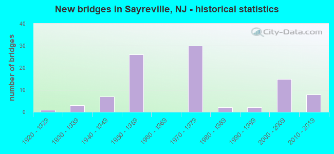
- New bridges - historical statistics
- 11920-1929
- 31930-1939
- 71940-1949
- 261950-1959
- 301970-1979
- 21980-1989
- 21990-1999
- 152000-2009
- 82010-2019

- Reconstructed bridges - Historical Statistics
- 31960-1969
- 11970-1979
- 11980-1989
- 11990-1999
- 32000-2009
- 22010-2019


- Bridge Condition - Deck
- 8.7%Very good
- 56.5%Good
- 30.4%Satisfactory
- 4.3%Fair

- Bridge Condition - Superstructure
- 13.0%Very good
- 28.3%Good
- 32.6%Satisfactory
- 26.1%Fair

- Bridge Condition - Substructure
- 2.2%Very good
- 37.0%Good
- 54.3%Satisfactory
- 6.5%Fair

- Bridge Condition - Channel
- 54.5%Very good
- 18.2%Good
- 27.3%Satisfactory
Find on map >> Show street view
Structure Number: 120715, Location: 2.15 MI NORTH OF RT 34 (Lat: 40.466669, Lng: -74.296939), Route carried "on" structure: US 9, Year Built: 1942, Year Reconstructed: 1981, Status: Open, Structure Length: 2.53m (8.30ft), Average Daily Traffic: 93,128 (year 2021), Truck Traffic: 4%, Average Future Daily Traffic: 111,753 (year 2041), Design Load: HS 20, Features Intersected: BORDENTOWN AVE (CO 615)
Minimum Vertical Clearance: 30+ m (98+ ft), Kilometerpoint: 207.670, Lanes on structure: 6, Lanes under structure: 4, Base Highway Network: Yes, Owner: State Highway Agency, Approaching Roadway Width: 24.4m (80.1ft), Skew: 33 degrees, Material/Design: Steel, Design/Construction: Stringer/Multi-beam, Number Of Spans In Main Unit: 2, Length of Maximum Span: 11.9m (39.0ft), Curb or Sidewalk Widths: Left: 1.8m (5.9ft), Right: 1.8m (5.9ft), Curb-To-Curb Width: 25.6m (84.0ft), Out-to-Out Width: 29.9m (98.1ft)
Condition: Deck: Satisfactory, Superstructure: Satisfactory, Substructure: Satisfactory, Operating Rating: 59.0 metric tons, Method Used To Determine Operating Rating: Load Factor (LF), Inventory Rating: 35.4 metric tons, Method Used To Determine Inventory Rating: Load Factor (LF), Structural Evaluation: Equal to present minimum criteria, Deck Geometry: Somewhat better than minimum adequacy, Underclear: Meets minimum limits, Approach Roadway Alignment: Better than present minimum criteria, Designated Inspection Frequency: Every 24 months, Inspection Date: July 2021, Deck Structure Type: Concrete Cast-file-Place, Wearing Surface/Protective System: Wearing Surface: Bituminous
Find on map >> Show street view
Structure Number: 1207152, Location: 1.23 miles S of GSP (Lat: 40.454139, Lng: -74.296911), Route carried "on" structure: US 9, Year Built: 1993, Status: Open, Structure Length: 3.63m (11.91ft), Average Daily Traffic: 91,224 (year 2021), Truck Traffic: 4%, Average Future Daily Traffic: 128,786 (year 2041), Design Load: HS 20+Mod, Features Intersected: ERNSTON ROAD (CR.673)
Minimum Vertical Clearance: 30+ m (98+ ft), Kilometerpoint: 206.109, Lanes on structure: 8, Lanes under structure: 6, Base Highway Network: Yes, Owner: State Highway Agency, Approaching Roadway Width: 33.5m (109.9ft), Skew: 37 degrees, Material/Design: Steel, Design/Construction: Stringer/Multi-beam, Number Of Spans In Main Unit: 1, Length of Maximum Span: 35.4m (116.1ft), Curb or Sidewalk Widths: Left: 1.8m (5.9ft), Right: 1.8m (5.9ft), Curb-To-Curb Width: 32.8m (107.6ft), Out-to-Out Width: 37.8m (124.0ft)
Condition: Deck: Good, Superstructure: Very good, Substructure: Good, Inventory Rating: 77.1 metric tons, Method Used To Determine Inventory Rating: Load Factor (LF), Structural Evaluation: Better than present minimum criteria, Deck Geometry: Somewhat better than minimum adequacy, Underclear: Better than present minimum criteria, Approach Roadway Alignment: Better than present minimum criteria, Designated Inspection Frequency: Every 24 months, Inspection Date: April 2021, Deck Structure Type: Concrete Cast-file-Place, Wearing Surface/Protective System: Wearing Surface: Latex Concrete, Deck Protection: Epoxy Coated Reinforcing
Find on map >> Show street view
Structure Number: 120815, Location: At MP 129.82 of US 9 (Lat: 40.477819, Lng: -74.290539), Route carried "on" structure: US 9, Year Built: 1936, Status: Open, Structure Length: 2.41m (7.91ft), Average Daily Traffic: 79,580 (year 2021), Truck Traffic: 4%, Average Future Daily Traffic: 95,495 (year 2041), Features Intersected: US9 NB & Main St
Minimum Vertical Clearance: 30+ m (98+ ft), Kilometerpoint: 209.086, Lanes on structure: 4, Lanes under structure: 3, Base Highway Network: Yes, Owner: State Highway Agency, Approaching Roadway Width: 15.5m (50.9ft), Skew: 32 degrees, Material/Design: Steel, Design/Construction: Stringer/Multi-beam, Number Of Spans In Main Unit: 2, Length of Maximum Span: 12.2m (40.0ft), Curb or Sidewalk Widths: Left: 1.9m (6.2ft), Right: 1.9m (6.2ft), Curb-To-Curb Width: 15.6m (51.2ft), Out-to-Out Width: 20.9m (68.6ft)
Condition: Deck: Satisfactory, Superstructure: Satisfactory, Substructure: Satisfactory, Operating Rating: 57.2 metric tons, Method Used To Determine Operating Rating: Load Factor (LF), Inventory Rating: 34.5 metric tons, Method Used To Determine Inventory Rating: Load Factor (LF), Structural Evaluation: Equal to present minimum criteria, Deck Geometry: Meets minimum limits, Underclear: Meets minimum limits, Approach Roadway Alignment: Equal to present desirable criteria, Designated Inspection Frequency: Every 24 months, Inspection Date: July 2021, Deck Structure Type: Concrete Cast-file-Place, Wearing Surface/Protective System: Wearing Surface: Bituminous, Membrane: Other
Find on map >> Show street view
Structure Number: 1208157, Location: 1.5 MI N OF 9-GSP JCT (Lat: 40.490089, Lng: -74.297950), Route carried "on" structure: City street , Year Built: 1941, Year Reconstructed: 1995, Status: Open, Structure Length: 3.11m (10.20ft), Average Daily Traffic: 2,866 (year 2019), Truck Traffic: 1%, Average Future Daily Traffic: 3,497 (year 2039), Features Intersected: US 9, Facility Carried by Structure: ANDREJEWSKI DRIVE
Minimum Vertical Clearance: 30+ m (98+ ft), Kilometerpoint: 0.000, Lanes on structure: 2, Lanes under structure: 6, Owner: State Highway Agency, Approaching Roadway Width: 9.1m (29.9ft), Skew: 1 degrees, Material/Design: Steel, Design/Construction: Stringer/Multi-beam, Number Of Spans In Main Unit: 2, Length of Maximum Span: 14.9m (48.9ft), Curb or Sidewalk Widths: Left: 1.8m (5.9ft), Right: 2.0m (6.6ft), Curb-To-Curb Width: 9.1m (29.9ft), Out-to-Out Width: 13.6m (44.6ft)
Condition: Deck: Fair, Superstructure: Satisfactory, Substructure: Fair, Operating Rating: 56.2 metric tons, Method Used To Determine Operating Rating: Load Factor (LF), Inventory Rating: 33.6 metric tons, Method Used To Determine Inventory Rating: Load Factor (LF), Structural Evaluation: Somewhat better than minimum adequacy, Deck Geometry: Meets minimum limits, Underclear: High priority of replacement, Approach Roadway Alignment: Equal to present minimum criteria, Length Of Structure Improvement: 3.11m (10.20ft), Designated Inspection Frequency: Every 24 months, Inspection Date: July 2021, Bridge Improvement Cost: $740,000, Roadway Improvement Cost: $22,000, Total Project Cost: $1,044,000 ( Estimate for 2019), Deck Structure Type: Concrete Cast-file-Place, Wearing Surface/Protective System: Wearing Surface: Latex Concrete
Find on map >> Show street view
Structure Number: 1209155, Location: 1.1 MI. S OF NJ 440 (Lat: 40.503781, Lng: -74.300531), Route carried "on" structure: US 9, Year Built: 2003, Status: Open, Structure Length: 133.87m (439.21ft), Average Daily Traffic: 45,408 (year 2021), Truck Traffic: 4%, Average Future Daily Traffic: 55,450 (year 2041), Design Load: HS 25 or greater, Features Intersected: RARITAN RIVER,SMITH ST.
Minimum Vertical Clearance: 30+ m (98+ ft), Kilometerpoint: 212.240, Lanes on structure: 3, Lanes under structure: 5, Base Highway Network: Yes, Owner: State Highway Agency, Approaching Roadway Width: 15.2m (49.9ft), Navigation Control: Yes ( Vertical Clearance: 33.5m (109.9ft), Horizontal Clearance: 61.0m (200.1ft)), Material/Design: Steel continuous, Design/Construction: Stringer/Multi-beam, Number Of Spans In Main Unit: 9, Number Of Approach Spans: 20, Length of Maximum Span: 76.2m (250.0ft), Curb or Sidewalk Widths: Left: 0.5m (1.6ft), Right: 0.5m (1.6ft), Curb-To-Curb Width: 15.0m (49.2ft), Out-to-Out Width: 16.0m (52.5ft)
Condition: Deck: Good, Superstructure: Good, Substructure: Good, Channel: Very good, Operating Rating: 52.6 metric tons, Method Used To Determine Operating Rating: Load Factor (LF), Inventory Rating: 31.8 metric tons, Method Used To Determine Inventory Rating: Load Factor (LF), Structural Evaluation: Better than present minimum criteria, Deck Geometry: Equal to present minimum criteria, Underclear: Meets minimum limits, Waterway Adequacy: Superior to present desirable criteria, Approach Roadway Alignment: Equal to present desirable criteria, Designated Inspection Frequency: Every 24 months, Underwater Inspection Frequency: Every 48 months, Inspection Date: July 2021, Underwater Inspection Date: October 2019, Deck Structure Type: Concrete Cast-file-Place, Wearing Surface/Protective System: Wearing Surface: Integral Concrete, Deck Protection: Epoxy Coated Reinforcing
Find on map >> Show street view
Structure Number: 1209156, Location: 1.08 MI. S OF NJ 440 (Lat: 40.515850, Lng: -74.300250), Route carried "on" structure: US 9, Year Built: 2002, Status: Open, Structure Length: 133.90m (439.30ft), Average Daily Traffic: 39,545 (year 2021), Truck Traffic: 4%, Average Future Daily Traffic: 47,454 (year 2041), Design Load: HS 25 or greater, Features Intersected: Raritan Riv,CR656,RampR
Minimum Vertical Clearance: 30+ m (98+ ft), Kilometerpoint: 212.272, Lanes on structure: 3, Lanes under structure: 5, Base Highway Network: Yes, Owner: State Highway Agency, Approaching Roadway Width: 14.9m (48.9ft), Navigation Control: Yes ( Vertical Clearance: 33.5m (109.9ft), Horizontal Clearance: 61.0m (200.1ft)), Material/Design: Steel continuous, Design/Construction: Stringer/Multi-beam, Number Of Spans In Main Unit: 9, Number Of Approach Spans: 17, Length of Maximum Span: 76.8m (252.0ft), Curb or Sidewalk Widths: Left: 0.5m (1.6ft), Right: 0.5m (1.6ft), Curb-To-Curb Width: 15.0m (49.2ft), Out-to-Out Width: 16.0m (52.5ft)
Condition: Deck: Good, Superstructure: Good, Substructure: Good, Channel: Very good, Operating Rating: 51.7 metric tons, Method Used To Determine Operating Rating: Load Factor (LF), Inventory Rating: 30.8 metric tons, Method Used To Determine Inventory Rating: Load Factor (LF), Structural Evaluation: Better than present minimum criteria, Deck Geometry: Equal to present minimum criteria, Underclear: Superior to present desirable criteria, Waterway Adequacy: Superior to present desirable criteria, Approach Roadway Alignment: Equal to present desirable criteria, Designated Inspection Frequency: Every 24 months, Critical Feature Inspection Frequency: Every 24 months, Underwater Inspection Frequency: Every 48 months, Inspection Date: July 2021, Critical Feature Inspection Date: July 2021, Underwater Inspection Date: October 2019, Deck Structure Type: Concrete Cast-file-Place, Wearing Surface/Protective System: Wearing Surface: Monolithic Concrete, Deck Protection: Epoxy Coated Reinforcing
Find on map >> Show street view
Structure Number: 1209157, Location: 0.8 MI S.of Raritan River (Lat: 40.496250, Lng: -74.297939), Route carried "on" structure: US 9, Year Built: 2005, Status: Open, Structure Length: 5.94m (19.49ft), Average Daily Traffic: 79,090 (year 2021), Truck Traffic: 4%, Average Future Daily Traffic: 96,505 (year 2041), Design Load: HS 25 or greater, Features Intersected: NJ 35 SB & CHEVALIER AV
Minimum Vertical Clearance: 30+ m (98+ ft), Kilometerpoint: 211.436, Lanes on structure: 7, Lanes under structure: 6, Base Highway Network: Yes, Owner: State Highway Agency, Approaching Roadway Width: 35.1m (115.2ft), Skew: 33 degrees, Material/Design: Steel continuous, Design/Construction: Stringer/Multi-beam, Number Of Spans In Main Unit: 2, Length of Maximum Span: 30.8m (101.0ft), Curb-To-Curb Width: 34.4m (112.9ft), Out-to-Out Width: 37.2m (122.0ft)
Condition: Deck: Good, Superstructure: Very good, Substructure: Good, Operating Rating: 66.2 metric tons, Method Used To Determine Operating Rating: Load Factor (LF), Inventory Rating: 39.9 metric tons, Method Used To Determine Inventory Rating: Load Factor (LF), Structural Evaluation: Better than present minimum criteria, Deck Geometry: Superior to present desirable criteria, Underclear: Equal to present minimum criteria, Approach Roadway Alignment: Equal to present desirable criteria, Designated Inspection Frequency: Every 24 months, Inspection Date: October 2021, Deck Structure Type: Concrete Cast-file-Place, Wearing Surface/Protective System: Wearing Surface: Monolithic Concrete, Deck Protection: Epoxy Coated Reinforcing
Find on map >> Show street view
Structure Number: 1222151, Location: 1.8 MI SE OF US9&NJ35 JCT (Lat: 40.464069, Lng: -74.261581), Route carried "on" structure: State highway 35, Year Built: 1924, Year Reconstructed: 1989, Status: Open, Structure Length: 4.75m (15.58ft), Average Daily Traffic: 14,917 (year 2021), Truck Traffic: 4%, Average Future Daily Traffic: 18,201 (year 2041), Features Intersected: NORTH JERSEY COAST LINE
Minimum Vertical Clearance: 5.51m (18.08ft), Kilometerpoint: 76.363, Lanes on structure: 2, Base Highway Network: Yes, Owner: State Highway Agency, Approaching Roadway Width: 8.8m (28.9ft), Skew: 5 degrees, Material/Design: Steel, Design/Construction: Truss - Thru, Number Of Spans In Main Unit: 1, Length of Maximum Span: 46.0m (150.9ft), Curb or Sidewalk Widths: Left: 1.5m (4.9ft), Right: 1.8m (5.9ft), Curb-To-Curb Width: 8.8m (28.9ft), Out-to-Out Width: 9.7m (31.8ft)
Condition: Deck: Good, Superstructure: Fair, Substructure: Good, Operating Rating: 33.6 metric tons, Method Used To Determine Operating Rating: Load Factor (LF), Inventory Rating: 20.0 metric tons, Method Used To Determine Inventory Rating: Load Factor (LF), Structural Evaluation: Somewhat better than minimum adequacy, Deck Geometry: High priority of corrective action, Underclear: Somewhat better than minimum adequacy, Approach Roadway Alignment: Better than present minimum criteria, Length Of Structure Improvement: 5.67m (18.60ft), Designated Inspection Frequency: Every 24 months, Critical Feature Inspection Frequency: Every 24 months, Inspection Date: Febuary 2021, Critical Feature Inspection Date: Febuary 2021, Bridge Improvement Cost: $4,229,000, Roadway Improvement Cost: $423,000, Total Project Cost: $7,594,000 ( Estimate for 2021), Deck Structure Type: Concrete Cast-file-Place, Wearing Surface/Protective System: Wearing Surface: Monolithic Concrete, Deck Protection: Epoxy Coated Reinforcing
Find on map >> Show street view
Structure Number: 1222152, Location: 1.8 MI SE OF US9&NJ35 JCT (Lat: 40.463850, Lng: -74.261400), Route carried "on" structure: State highway 35, Year Built: 1946, Status: Open, Structure Length: 3.44m (11.29ft), Average Daily Traffic: 18,929 (year 2021), Truck Traffic: 4%, Average Future Daily Traffic: 23,096 (year 2041), Design Load: H 20, Features Intersected: NORTH JERSEY COAST LINE
Minimum Vertical Clearance: 30+ m (98+ ft), Kilometerpoint: 76.363, Lanes on structure: 2, Base Highway Network: Yes, Owner: State Highway Agency, Approaching Roadway Width: 9.8m (32.2ft), Skew: 5 degrees, Material/Design: Steel, Design/Construction: Girder and Floorbeam System, Number Of Spans In Main Unit: 1, Length of Maximum Span: 32.9m (107.9ft), Curb or Sidewalk Widths: Left: 1.7m (5.6ft), Right: 0.0m, Curb-To-Curb Width: 9.8m (32.2ft), Out-to-Out Width: 10.3m (33.8ft)
Condition: Deck: Satisfactory, Superstructure: Satisfactory, Substructure: Satisfactory, Operating Rating: 54.4 metric tons, Method Used To Determine Operating Rating: Load Factor (LF), Inventory Rating: 32.7 metric tons, Method Used To Determine Inventory Rating: Load Factor (LF), Structural Evaluation: Equal to present minimum criteria, Deck Geometry: Meets minimum limits, Underclear: Somewhat better than minimum adequacy, Approach Roadway Alignment: Better than present minimum criteria, Designated Inspection Frequency: Every 24 months, Critical Feature Inspection Frequency: Every 24 months, Inspection Date: Febuary 2021, Critical Feature Inspection Date: Febuary 2021, Deck Structure Type: Concrete Cast-file-Place, Wearing Surface/Protective System: Wearing Surface: Bituminous
Find on map >> Show street view
Structure Number: 1222153, Location: 1.5 MI SO OF RT 9 JCT (Lat: 40.464600, Lng: -74.273550), Route carried "on" structure: County highway 688, Year Built: 1936, Status: Open, Structure Length: 1.49m (4.89ft), Average Daily Traffic: 5,558 (year 2020), Truck Traffic: 3%, Average Future Daily Traffic: 6,670 (year 2040), Features Intersected: NJ 35 NB
Minimum Vertical Clearance: 30+ m (98+ ft), Kilometerpoint: 0.000, Lanes on structure: 2, Lanes under structure: 2, Owner: State Highway Agency, Approaching Roadway Width: 8.8m (28.9ft), Skew: 4 degrees, Material/Design: Steel, Design/Construction: Stringer/Multi-beam, Number Of Spans In Main Unit: 1, Length of Maximum Span: 13.7m (44.9ft), Curb or Sidewalk Widths: Left: 2.0m (6.6ft), Right: 2.0m (6.6ft), Curb-To-Curb Width: 8.8m (28.9ft), Out-to-Out Width: 13.6m (44.6ft)
Condition: Deck: Good, Superstructure: Fair, Substructure: Satisfactory, Operating Rating: 49.9 metric tons, Method Used To Determine Operating Rating: Load Factor (LF), Inventory Rating: 29.9 metric tons, Method Used To Determine Inventory Rating: Load Factor (LF), Structural Evaluation: Somewhat better than minimum adequacy, Deck Geometry: High priority of corrective action, Underclear: High priority of corrective action, Approach Roadway Alignment: Somewhat better than minimum adequacy, Length Of Structure Improvement: 1.49m (4.89ft), Designated Inspection Frequency: Every 24 months, Inspection Date: August 2020, Bridge Improvement Cost: $551,000, Roadway Improvement Cost: $7,000, Total Project Cost: $853,000 ( Estimate for 2020), Deck Structure Type: Concrete Cast-file-Place, Wearing Surface/Protective System: Wearing Surface: Bituminous, Membrane: Other
Find on map >> Show street view
Structure Number: 1234168, Location: BETWEEN GSP&US 9 BRIDGES (Lat: 40.515719, Lng: -74.300619), Route carried "on" structure: Ramp US 9, Year Built: 1972, Status: Open, Structure Length: 2.59m (8.50ft), Average Daily Traffic: 2,154 (year 2020), Truck Traffic: 4%, Average Future Daily Traffic: 2,585 (year 2040), Design Load: HS 20+Mod, Features Intersected: CO.RT.656(SMITH ST) WB, Facility Carried by Structure: RAMP R
Minimum Vertical Clearance: 30+ m (98+ ft), Kilometerpoint: 213.512, Lanes on structure: 1, Lanes under structure: 2, Owner: State Highway Agency, Approaching Roadway Width: 6.7m (22.0ft), Material/Design: Steel, Design/Construction: Stringer/Multi-beam, Number Of Spans In Main Unit: 1, Length of Maximum Span: 24.1m (79.1ft), Curb or Sidewalk Widths: Left: 0.5m (1.6ft), Right: 0.8m (2.6ft), Curb-To-Curb Width: 6.7m (22.0ft), Out-to-Out Width: 8.7m (28.5ft)
Condition: Deck: Satisfactory, Superstructure: Good, Substructure: Good, Operating Rating: 77.1 metric tons, Method Used To Determine Operating Rating: Load Factor (LF), Inventory Rating: 46.3 metric tons, Method Used To Determine Inventory Rating: Load Factor (LF), Structural Evaluation: Better than present minimum criteria, Deck Geometry: Equal to present minimum criteria, Underclear: Meets minimum limits, Approach Roadway Alignment: Equal to present minimum criteria, Designated Inspection Frequency: Every 24 months, Inspection Date: March 2020, Deck Structure Type: Concrete Cast-file-Place, Wearing Surface/Protective System: Wearing Surface: Monolithic Concrete
Find on map >> Show street view
Structure Number: 123B076, Location: 0.21 miles south of CR675 (Lat: 40.428039, Lng: -74.344281), Route carried "on" structure: County highway 615, Year Built: 1983, Status: Open, Structure Length: 2.04m (6.69ft), Average Daily Traffic: 10,989 (year 2021), Truck Traffic: 4%, Average Future Daily Traffic: 13,409 (year 2041), Design Load: HS 20+Mod, Features Intersected: TENNENTS BROOK, Facility Carried by Structure: BORDENTOWN AVENUE
Minimum Vertical Clearance: 30+ m (98+ ft), Kilometerpoint: 29.966, Lanes on structure: 2, Owner: County Highway Agency, Approaching Roadway Width: 12.8m (42.0ft), Material/Design: Prestressed concrete, Design/Construction: Box Beam or Girders - Multiple, Number Of Spans In Main Unit: 1, Length of Maximum Span: 19.2m (63.0ft), Curb or Sidewalk Widths: Left: 0.2m (0.7ft), Right: 0.2m (0.7ft), Curb-To-Curb Width: 12.7m (41.7ft), Out-to-Out Width: 14.2m (46.6ft)
Condition: Deck: Fair, Superstructure: Good, Substructure: Good, Channel: Satisfactory, Operating Rating: 42.6 metric tons, Method Used To Determine Operating Rating: Load Factor (LF), Inventory Rating: 25.4 metric tons, Method Used To Determine Inventory Rating: Load Factor (LF), Structural Evaluation: Equal to present minimum criteria, Deck Geometry: Somewhat better than minimum adequacy, Waterway Adequacy: Equal to present minimum criteria, Approach Roadway Alignment: Equal to present desirable criteria, Designated Inspection Frequency: Every 24 months, Inspection Date: June 2021, Deck Structure Type: Concrete Cast-file-Place, Wearing Surface/Protective System: Wearing Surface: Monolithic Concrete, Deck Protection: Epoxy Coated Reinforcing
Find on map >> Show street view
Structure Number: 123B077, Location: 0.57 miles north of CR677 (Lat: 40.421381, Lng: -74.354019), Route carried "on" structure: County highway 615, Year Built: 1987, Status: Open, Structure Length: 1.37m (4.49ft), Average Daily Traffic: 10,989 (year 2021), Truck Traffic: 4%, Average Future Daily Traffic: 13,409 (year 2041), Features Intersected: DEEP RUN
Minimum Vertical Clearance: 30+ m (98+ ft), Kilometerpoint: 28.839, Lanes on structure: 2, Owner: County Highway Agency, Approaching Roadway Width: 9.4m (30.8ft), Material/Design: Prestressed concrete, Design/Construction: Box Beam or Girders - Multiple, Number Of Spans In Main Unit: 1, Length of Maximum Span: 12.5m (41.0ft), Curb or Sidewalk Widths: Left: 2.7m (8.9ft), Right: 0.0m, Curb-To-Curb Width: 9.4m (30.8ft), Out-to-Out Width: 16.2m (53.1ft)
Condition: Deck: Good, Superstructure: Good, Substructure: Satisfactory, Channel: Good, Inventory Rating: 27.2 metric tons, Method Used To Determine Inventory Rating: Load Factor (LF), Structural Evaluation: Equal to present minimum criteria, Deck Geometry: High priority of corrective action, Waterway Adequacy: Somewhat better than minimum adequacy, Approach Roadway Alignment: Equal to present desirable criteria, Length Of Structure Improvement: 1.37m (4.49ft), Designated Inspection Frequency: Every 24 months, Underwater Inspection Frequency: Every 48 months, Inspection Date: June 2021, Underwater Inspection Date: August 2019, Deck Structure Type: Concrete Cast-file-Place, Wearing Surface/Protective System: Wearing Surface: Monolithic Concrete, Deck Protection: Epoxy Coated Reinforcing
Find on map >> Show street view
Structure Number: 123B081, Location: 1.44 miles west of CR 535 (Lat: 40.474081, Lng: -74.321900), Route carried "on" structure: County highway 670, Year Built: 1978, Status: Open, Structure Length: 0.88m (2.89ft), Average Daily Traffic: 12,303 (year 2021), Truck Traffic: 3%, Average Future Daily Traffic: 15,012 (year 2041), Design Load: HS 20, Features Intersected: BURTS CREEK, Facility Carried by Structure: MAIN STREET
Minimum Vertical Clearance: 30+ m (98+ ft), Kilometerpoint: 4.780, Lanes on structure: 2, Owner: County Highway Agency, Approaching Roadway Width: 11.0m (36.1ft), Material/Design: Concrete, Design/Construction: Culvert, Number Of Spans In Main Unit: 2, Length of Maximum Span: 4.3m (14.1ft), Curb or Sidewalk Widths: Left: 1.5m (4.9ft), Right: 1.4m (4.6ft)
Condition: Channel: Satisfactory, Culverts: Satisfactory, Inventory Rating: 71.7 metric tons, Method Used To Determine Inventory Rating: Load Factor (LF), Structural Evaluation: Equal to present minimum criteria, Waterway Adequacy: Equal to present minimum criteria, Approach Roadway Alignment: Equal to present desirable criteria, Designated Inspection Frequency: Every 24 months, Underwater Inspection Frequency: Every 24 months, Inspection Date: April 2021, Underwater Inspection Date: April 2021
Find on map >> Show street view
Structure Number: 1255162, Location: 0.3 mi West of US9 (Lat: 40.475919, Lng: -74.295900), Route carried "on" structure: County highway 670, Year Built: 1955, Status: Open, Structure Length: 3.81m (12.50ft), Average Daily Traffic: 10,080 (year 2020), Truck Traffic: 4%, Average Future Daily Traffic: 12,300 (year 2040), Design Load: HS 20, Features Intersected: AMBOY SECONDARY, Facility Carried by Structure: Washington St
Minimum Vertical Clearance: 30+ m (98+ ft), Kilometerpoint: 7.162, Lanes on structure: 2, Maintenance Responsibility: State Highway Agency, Approaching Roadway Width: 9.1m (29.9ft), Skew: 1 degrees, Material/Design: Steel, Design/Construction: Stringer/Multi-beam, Number Of Spans In Main Unit: 3, Length of Maximum Span: 18.0m (59.1ft), Curb or Sidewalk Widths: Left: 1.1m (3.6ft), Right: 0.0m, Curb-To-Curb Width: 9.2m (30.2ft), Out-to-Out Width: 11.6m (38.1ft)
Condition: Deck: Satisfactory, Superstructure: Fair, Substructure: Satisfactory, Operating Rating: 70.8 metric tons, Method Used To Determine Operating Rating: Load Factor (LF), Inventory Rating: 41.7 metric tons, Method Used To Determine Inventory Rating: Load Factor (LF), Structural Evaluation: Somewhat better than minimum adequacy, Deck Geometry: High priority of corrective action, Underclear: Meets minimum limits, Approach Roadway Alignment: High priority of corrective action, Length Of Structure Improvement: 3.81m (12.50ft), Designated Inspection Frequency: Every 24 months, Critical Feature Inspection Frequency: Every 24 months, Inspection Date: November 2020, Critical Feature Inspection Date: November 2020, Bridge Improvement Cost: $85,000, Roadway Improvement Cost: $113,000, Total Project Cost: $315,000 ( Estimate for 2020), Deck Structure Type: Concrete Cast-file-Place, Wearing Surface/Protective System: Wearing Surface: Bituminous
Find on map >> Show street view
Structure Number: 361228E, Location: 1.84 mi. S. of GSP/NJ9 Jc (Lat: 40.454222, Lng: -74.273667), Route carried "on" structure: Other road GSP, Year Built: 1974, Status: Open, Structure Length: 6.00m (19.69ft), Average Daily Traffic: 28,384 (year 2020), Truck Traffic: 1%, Average Future Daily Traffic: 34,634 (year 2040), Design Load: HS 20, Features Intersected: CHEESEQUAKE CREEK
Minimum Vertical Clearance: 30+ m (98+ ft), Kilometerpoint: 197.627, Lanes on structure: 3, Base Highway Network: Yes, Toll: On toll road, Owner: State Toll Authority, Approaching Roadway Width: 11.6m (38.1ft), Material/Design: Steel, Design/Construction: Stringer/Multi-beam, Number Of Spans In Main Unit: 3, Length of Maximum Span: 20.1m (65.9ft), Curb-To-Curb Width: 11.6m (38.1ft), Out-to-Out Width: 12.6m (41.3ft)
Condition: Deck: Good, Superstructure: Fair, Substructure: Fair, Channel: Very good, Operating Rating: 63.2 metric tons, Method Used To Determine Operating Rating: Load and Resistance Factor Rating (LRFR) rating reported by rating factor(RF) method using HL-93 loadings, Inventory Rating: 48.6 metric tons, Method Used To Determine Inventory Rating: Load and Resistance Factor Rating (LRFR) rating reported by rating factor(RF) method using HL-93 loadings, Structural Evaluation: Somewhat better than minimum adequacy, Deck Geometry: High priority of replacement, Waterway Adequacy: Equal to present desirable criteria, Approach Roadway Alignment: Better than present minimum criteria, Length Of Structure Improvement: 6.04m (19.82ft), Designated Inspection Frequency: Every 24 months, Underwater Inspection Frequency: Every 48 months, Inspection Date: August 2020, Underwater Inspection Date: September 2018, Bridge Improvement Cost: $380,000, Roadway Improvement Cost: $100,000, Total Project Cost: $635,000 ( Estimate for 2018), Deck Structure Type: Concrete Cast-file-Place, Wearing Surface/Protective System: Wearing Surface: Bituminous
Find on map >> Show street view
Structure Number: 361228U, Location: 1.84 mi. S of GSP/NJ9 Jct (Lat: 40.454194, Lng: -74.273694), Route carried "on" structure: Other road GSP, Year Built: 1954, Status: Open, Structure Length: 6.04m (19.82ft), Average Daily Traffic: 54,983 (year 2020), Truck Traffic: 1%, Average Future Daily Traffic: 67,090 (year 2040), Design Load: H 20, Features Intersected: CHEESEQUAKE CREEK
Minimum Vertical Clearance: 30+ m (98+ ft), Kilometerpoint: 197.627, Lanes on structure: 3, Base Highway Network: Yes, Toll: On toll road, Owner: State Toll Authority, Approaching Roadway Width: 14.3m (46.9ft), Material/Design: Steel, Design/Construction: Stringer/Multi-beam, Number Of Spans In Main Unit: 3, Length of Maximum Span: 20.1m (65.9ft), Curb-To-Curb Width: 14.4m (47.2ft), Out-to-Out Width: 15.5m (50.9ft)
Condition: Deck: Good, Superstructure: Fair, Substructure: Satisfactory, Channel: Very good, Operating Rating: 42.1 metric tons, Method Used To Determine Operating Rating: Load and Resistance Factor Rating (LRFR) rating reported by rating factor(RF) method using HL-93 loadings, Inventory Rating: 32.4 metric tons, Method Used To Determine Inventory Rating: Load and Resistance Factor Rating (LRFR) rating reported by rating factor(RF) method using HL-93 loadings, Structural Evaluation: Somewhat better than minimum adequacy, Deck Geometry: Meets minimum limits, Waterway Adequacy: Equal to present desirable criteria, Approach Roadway Alignment: Better than present minimum criteria, Designated Inspection Frequency: Every 24 months, Underwater Inspection Frequency: Every 48 months, Inspection Date: September 2020, Underwater Inspection Date: September 2018, Deck Structure Type: Concrete Cast-file-Place, Wearing Surface/Protective System: Wearing Surface: Bituminous
Find on map >> Show street view
Structure Number: 361229I, Location: 1.84 mi. S of GSP/US9 Jct (Lat: 40.453889, Lng: -74.272944), Route carried "on" structure: Other road GSP, Year Built: 1974, Status: Open, Structure Length: 6.04m (19.82ft), Average Daily Traffic: 41,926 (year 2020), Truck Traffic: 1%, Average Future Daily Traffic: 51,158 (year 2040), Design Load: HS 20, Features Intersected: CHEESEQUAKE CREEK
Minimum Vertical Clearance: 30+ m (98+ ft), Kilometerpoint: 197.627, Lanes on structure: 3, Base Highway Network: Yes, Toll: On toll road, Owner: State Toll Authority, Approaching Roadway Width: 11.6m (38.1ft), Material/Design: Steel, Design/Construction: Stringer/Multi-beam, Number Of Spans In Main Unit: 3, Length of Maximum Span: 20.1m (65.9ft), Curb-To-Curb Width: 11.6m (38.1ft), Out-to-Out Width: 12.6m (41.3ft)
Condition: Deck: Good, Superstructure: Satisfactory, Substructure: Satisfactory, Channel: Very good, Operating Rating: 63.2 metric tons, Method Used To Determine Operating Rating: Load and Resistance Factor Rating (LRFR) rating reported by rating factor(RF) method using HL-93 loadings, Inventory Rating: 48.6 metric tons, Method Used To Determine Inventory Rating: Load and Resistance Factor Rating (LRFR) rating reported by rating factor(RF) method using HL-93 loadings, Structural Evaluation: Equal to present minimum criteria, Deck Geometry: High priority of replacement, Waterway Adequacy: Equal to present desirable criteria, Approach Roadway Alignment: Better than present minimum criteria, Length Of Structure Improvement: 6.04m (19.82ft), Designated Inspection Frequency: Every 24 months, Underwater Inspection Frequency: Every 48 months, Inspection Date: August 2020, Underwater Inspection Date: September 2018, Bridge Improvement Cost: $100,000, Roadway Improvement Cost: $100,000, Total Project Cost: $200,000 ( Estimate for 2016), Deck Structure Type: Concrete Cast-file-Place, Wearing Surface/Protective System: Wearing Surface: Bituminous
Find on map >> Show street view
Structure Number: 361229O, Location: 1.84 mi. S of GSP/US9 Jct (Lat: 40.453944, Lng: -74.239417), Route carried "on" structure: Other road GSP, Year Built: 1954, Status: Open, Structure Length: 6.04m (19.82ft), Average Daily Traffic: 52,153 (year 2020), Truck Traffic: 1%, Average Future Daily Traffic: 63,636 (year 2040), Design Load: H 20, Features Intersected: CHEESEQUAKE CREEK
Minimum Vertical Clearance: 30+ m (98+ ft), Kilometerpoint: 197.627, Lanes on structure: 3, Base Highway Network: Yes, Toll: On toll road, Owner: State Toll Authority, Approaching Roadway Width: 14.3m (46.9ft), Material/Design: Steel, Design/Construction: Stringer/Multi-beam, Number Of Spans In Main Unit: 3, Length of Maximum Span: 20.1m (65.9ft), Curb-To-Curb Width: 14.4m (47.2ft), Out-to-Out Width: 15.5m (50.9ft)
Condition: Deck: Good, Superstructure: Fair, Substructure: Satisfactory, Channel: Very good, Operating Rating: 40.5 metric tons, Method Used To Determine Operating Rating: Load and Resistance Factor Rating (LRFR) rating reported by rating factor(RF) method using HL-93 loadings, Inventory Rating: 31.1 metric tons, Method Used To Determine Inventory Rating: Load and Resistance Factor Rating (LRFR) rating reported by rating factor(RF) method using HL-93 loadings, Structural Evaluation: Somewhat better than minimum adequacy, Deck Geometry: Meets minimum limits, Waterway Adequacy: Equal to present desirable criteria, Approach Roadway Alignment: Equal to present desirable criteria, Designated Inspection Frequency: Every 24 months, Underwater Inspection Frequency: Every 48 months, Inspection Date: September 2020, Underwater Inspection Date: September 2018, Deck Structure Type: Concrete Cast-file-Place, Wearing Surface/Protective System: Wearing Surface: Bituminous, Membrane: Preformed Fabric, Deck Protection: Other Coated Reinforcing
Find on map >> Show street view
Structure Number: 361235E, Location: 2.5 MI S OF RARITAN TOLL (Lat: 40.461058, Lng: -74.280878), Route carried "on" structure: Other road GSP, Year Built: 1972, Status: Open, Structure Length: 3.78m (12.40ft), Average Daily Traffic: 35,203 (year 2021), Truck Traffic: 1%, Average Future Daily Traffic: 42,955 (year 2041), Design Load: H 20, Features Intersected: ERNSTON ROAD, Facility Carried by Structure: GARDEN ST PKWY SBI
Minimum Vertical Clearance: 30+ m (98+ ft), Kilometerpoint: 198.818, Lanes on structure: 4, Lanes under structure: 2, Base Highway Network: Yes, Toll: On toll road, Owner: State Toll Authority, Approaching Roadway Width: 16.2m (53.1ft), Material/Design: Prestressed concrete, Design/Construction: Box Beam or Girders - Single/Spread, Number Of Spans In Main Unit: 3, Length of Maximum Span: 15.8m (51.8ft), Curb-To-Curb Width: 15.1m (49.5ft), Out-to-Out Width: 16.0m (52.5ft)
Condition: Deck: Good, Superstructure: Fair, Substructure: Satisfactory, Operating Rating: 40.2 metric tons, Method Used To Determine Operating Rating: Load and Resistance Factor Rating (LRFR) rating reported by rating factor(RF) method using HL-93 loadings, Inventory Rating: 30.1 metric tons, Method Used To Determine Inventory Rating: Load and Resistance Factor Rating (LRFR) rating reported by rating factor(RF) method using HL-93 loadings, Structural Evaluation: Somewhat better than minimum adequacy, Deck Geometry: High priority of replacement, Underclear: Meets minimum limits, Approach Roadway Alignment: Equal to present desirable criteria, Length Of Structure Improvement: 3.75m (12.30ft), Designated Inspection Frequency: Every 24 months, Inspection Date: Febuary 2021, Bridge Improvement Cost: $2,730,000, Roadway Improvement Cost: $573,000, Total Project Cost: $4,556,000 ( Estimate for 2017), Deck Structure Type: Concrete Cast-file-Place, Wearing Surface/Protective System: Wearing Surface: Bituminous, Membrane: Preformed Fabric
Find on map >> Show street view
Structure Number: 361235U, Location: 2.5 MI S OF RARITAN TOLL (Lat: 40.460883, Lng: -74.281047), Route carried "on" structure: Other road GSP, Year Built: 1954, Year Reconstructed: 1972, Status: Open, Structure Length: 3.78m (12.40ft), Average Daily Traffic: 64,896 (year 2021), Truck Traffic: 1%, Average Future Daily Traffic: 79,186 (year 2041), Design Load: H 20, Features Intersected: ERNSTON ROAD, Facility Carried by Structure: GARDEN ST PKWY SBO
Minimum Vertical Clearance: 30+ m (98+ ft), Kilometerpoint: 198.818, Lanes on structure: 4, Lanes under structure: 2, Base Highway Network: Yes, Toll: On toll road, Owner: State Toll Authority, Approaching Roadway Width: 19.2m (63.0ft), Material/Design: Steel, Design/Construction: Stringer/Multi-beam, Number Of Spans In Main Unit: 3, Length of Maximum Span: 15.8m (51.8ft), Curb-To-Curb Width: 19.2m (63.0ft), Out-to-Out Width: 20.1m (65.9ft)
Condition: Deck: Satisfactory, Superstructure: Satisfactory, Substructure: Fair, Operating Rating: 48.9 metric tons, Method Used To Determine Operating Rating: Load and Resistance Factor Rating (LRFR) rating reported by rating factor(RF) method using HL-93 loadings, Inventory Rating: 37.6 metric tons, Method Used To Determine Inventory Rating: Load and Resistance Factor Rating (LRFR) rating reported by rating factor(RF) method using HL-93 loadings, Structural Evaluation: Somewhat better than minimum adequacy, Deck Geometry: Somewhat better than minimum adequacy, Underclear: Meets minimum limits, Approach Roadway Alignment: Equal to present desirable criteria, Designated Inspection Frequency: Every 24 months, Inspection Date: Febuary 2021, Deck Structure Type: Concrete Cast-file-Place, Wearing Surface/Protective System: Wearing Surface: Bituminous, Membrane: Preformed Fabric
Find on map >> Show street view
Structure Number: 361236I, Location: 2.5 MI S OF RARITAN TOLL (Lat: 40.461319, Lng: -74.280614), Route carried "on" structure: Other road GSP, Year Built: 1972, Status: Open, Structure Length: 3.51m (11.52ft), Average Daily Traffic: 43,907 (year 2021), Truck Traffic: 1%, Average Future Daily Traffic: 53,575 (year 2041), Design Load: H 20, Features Intersected: ERNSTON ROAD
Minimum Vertical Clearance: 30+ m (98+ ft), Kilometerpoint: 198.818, Lanes on structure: 4, Lanes under structure: 2, Base Highway Network: Yes, Toll: On toll road, Owner: State Toll Authority, Approaching Roadway Width: 16.2m (53.1ft), Material/Design: Prestressed concrete, Design/Construction: Box Beam or Girders - Single/Spread, Number Of Spans In Main Unit: 3, Length of Maximum Span: 15.8m (51.8ft), Curb-To-Curb Width: 15.1m (49.5ft), Out-to-Out Width: 16.0m (52.5ft)
Condition: Deck: Good, Superstructure: Fair, Substructure: Good, Operating Rating: 44.4 metric tons, Method Used To Determine Operating Rating: Load and Resistance Factor Rating (LRFR) rating reported by rating factor(RF) method using HL-93 loadings, Inventory Rating: 31.1 metric tons, Method Used To Determine Inventory Rating: Load and Resistance Factor Rating (LRFR) rating reported by rating factor(RF) method using HL-93 loadings, Structural Evaluation: Somewhat better than minimum adequacy, Deck Geometry: High priority of replacement, Underclear: Meets minimum limits, Approach Roadway Alignment: Equal to present desirable criteria, Length Of Structure Improvement: 3.51m (11.52ft), Designated Inspection Frequency: Every 24 months, Inspection Date: Febuary 2021, Bridge Improvement Cost: $2,459,000, Roadway Improvement Cost: $517,000, Total Project Cost: $4,105,000 ( Estimate for 2017), Deck Structure Type: Concrete Cast-file-Place, Wearing Surface/Protective System: Wearing Surface: Bituminous, Membrane: Preformed Fabric
Find on map >> Show street view
Structure Number: 361236O, Location: 2.5 MI S OF RARITAN TOLL (Lat: 40.461447, Lng: -74.297078), Route carried "on" structure: Other road GSP, Year Built: 1954, Year Reconstructed: 1972, Status: Open, Structure Length: 3.75m (12.30ft), Average Daily Traffic: 57,881 (year 2021), Truck Traffic: 1%, Average Future Daily Traffic: 70,626 (year 2041), Design Load: H 20, Features Intersected: ERNSTON ROAD, Facility Carried by Structure: GARDEN ST PKWY NBO
Minimum Vertical Clearance: 30+ m (98+ ft), Kilometerpoint: 198.818, Lanes on structure: 4, Lanes under structure: 2, Base Highway Network: Yes, Toll: On toll road, Owner: State Toll Authority, Approaching Roadway Width: 21.0m (68.9ft), Material/Design: Steel, Design/Construction: Stringer/Multi-beam, Number Of Spans In Main Unit: 3, Length of Maximum Span: 15.8m (51.8ft), Curb-To-Curb Width: 20.0m (65.6ft), Out-to-Out Width: 20.9m (68.6ft)
Condition: Deck: Satisfactory, Superstructure: Satisfactory, Substructure: Satisfactory, Operating Rating: 47.3 metric tons, Method Used To Determine Operating Rating: Load and Resistance Factor Rating (LRFR) rating reported by rating factor(RF) method using HL-93 loadings, Inventory Rating: 36.3 metric tons, Method Used To Determine Inventory Rating: Load and Resistance Factor Rating (LRFR) rating reported by rating factor(RF) method using HL-93 loadings, Structural Evaluation: Equal to present minimum criteria, Deck Geometry: Equal to present minimum criteria, Underclear: Meets minimum limits, Approach Roadway Alignment: Equal to present desirable criteria, Designated Inspection Frequency: Every 24 months, Inspection Date: Febuary 2021, Deck Structure Type: Concrete Cast-file-Place, Wearing Surface/Protective System: Wearing Surface: Bituminous, Membrane: Preformed Fabric
Find on map >> Show street view
Structure Number: 361238E, Location: 2.1 MI S OF RARITAN TOLL (Lat: 40.463578, Lng: -74.285789), Route carried "on" structure: Other road GSP, Year Built: 1972, Status: Open, Structure Length: 1.80m (5.91ft), Average Daily Traffic: 35,015 (year 2021), Truck Traffic: 1%, Average Future Daily Traffic: 42,725 (year 2041), Design Load: H 20, Features Intersected: RAMP A FROM SERV. AREA, Facility Carried by Structure: GARDEN ST PKWY SBI
Minimum Vertical Clearance: 30+ m (98+ ft), Kilometerpoint: 199.237, Lanes on structure: 3, Lanes under structure: 3, Base Highway Network: Yes, Toll: On toll road, Owner: State Toll Authority, Approaching Roadway Width: 12.5m (41.0ft), Skew: 3 degrees, Material/Design: Prestressed concrete, Design/Construction: Stringer/Multi-beam, Number Of Spans In Main Unit: 1, Length of Maximum Span: 16.5m (54.1ft), Curb-To-Curb Width: 11.4m (37.4ft), Out-to-Out Width: 12.3m (40.4ft)
Condition: Deck: Good, Superstructure: Good, Substructure: Good, Operating Rating: 59.9 metric tons, Method Used To Determine Operating Rating: Load and Resistance Factor Rating (LRFR) rating reported by rating factor(RF) method using HL-93 loadings, Inventory Rating: 43.4 metric tons, Method Used To Determine Inventory Rating: Load and Resistance Factor Rating (LRFR) rating reported by rating factor(RF) method using HL-93 loadings, Structural Evaluation: Better than present minimum criteria, Deck Geometry: High priority of replacement, Underclear: High priority of corrective action, Approach Roadway Alignment: Equal to present desirable criteria, Length Of Structure Improvement: 1.77m (5.81ft), Designated Inspection Frequency: Every 24 months, Inspection Date: March 2021, Bridge Improvement Cost: $1,045,000, Roadway Improvement Cost: $220,000, Total Project Cost: $1,744,000 ( Estimate for 2017), Deck Structure Type: Concrete Cast-file-Place, Wearing Surface/Protective System: Wearing Surface: Bituminous, Membrane: Preformed Fabric
Find on map >> Show street view
Structure Number: 361238I, Location: 2.1 MI S OF RARITAN TOLL (Lat: 40.463928, Lng: -74.284733), Route carried "on" structure: Other road GSP, Year Built: 1972, Status: Open, Structure Length: 2.38m (7.81ft), Average Daily Traffic: 42,283 (year 2021), Truck Traffic: 1%, Average Future Daily Traffic: 51,594 (year 2041), Design Load: H 20, Features Intersected: RAMP C TO SERVICE AREA, Facility Carried by Structure: GARDEN ST PKWY NBI
Minimum Vertical Clearance: 30+ m (98+ ft), Kilometerpoint: 199.237, Lanes on structure: 3, Lanes under structure: 1, Base Highway Network: Yes, Toll: On toll road, Owner: State Toll Authority, Approaching Roadway Width: 11.3m (37.1ft), Skew: 4 degrees, Material/Design: Prestressed concrete, Design/Construction: Stringer/Multi-beam, Number Of Spans In Main Unit: 1, Length of Maximum Span: 21.9m (71.9ft), Curb-To-Curb Width: 11.4m (37.4ft), Out-to-Out Width: 12.3m (40.4ft)
Condition: Deck: Good, Superstructure: Good, Substructure: Satisfactory, Operating Rating: 60.9 metric tons, Method Used To Determine Operating Rating: Load and Resistance Factor Rating (LRFR) rating reported by rating factor(RF) method using HL-93 loadings, Inventory Rating: 27.9 metric tons, Method Used To Determine Inventory Rating: Load and Resistance Factor Rating (LRFR) rating reported by rating factor(RF) method using HL-93 loadings, Structural Evaluation: Equal to present minimum criteria, Deck Geometry: High priority of replacement, Underclear: Meets minimum limits, Approach Roadway Alignment: Equal to present desirable criteria, Length Of Structure Improvement: 2.37m (7.78ft), Designated Inspection Frequency: Every 24 months, Inspection Date: March 2021, Bridge Improvement Cost: $1,388,000, Roadway Improvement Cost: $292,000, Total Project Cost: $2,317,000 ( Estimate for 2015), Deck Structure Type: Concrete Cast-file-Place, Wearing Surface/Protective System: Wearing Surface: Bituminous, Membrane: Preformed Fabric
Find on map >> Show street view
Structure Number: 361238O, Location: 2.1 MI S OF RARITAN TOLL (Lat: 40.463969, Lng: -74.283603), Route carried "on" structure: Other road GSP, Year Built: 1972, Status: Open, Structure Length: 2.13m (6.99ft), Average Daily Traffic: 53,994 (year 2021), Truck Traffic: 1%, Average Future Daily Traffic: 65,882 (year 2041), Design Load: H 20, Features Intersected: RAMP C TO SERVICE AREA, Facility Carried by Structure: GARDEN ST PKWY NBO
Minimum Vertical Clearance: 30+ m (98+ ft), Kilometerpoint: 199.237, Lanes on structure: 3, Lanes under structure: 1, Base Highway Network: Yes, Toll: On toll road, Owner: State Toll Authority, Approaching Roadway Width: 16.2m (53.1ft), Skew: 4 degrees, Material/Design: Prestressed concrete, Design/Construction: Stringer/Multi-beam, Number Of Spans In Main Unit: 1, Length of Maximum Span: 19.5m (64.0ft), Curb-To-Curb Width: 15.1m (49.5ft), Out-to-Out Width: 16.0m (52.5ft)
Condition: Deck: Good, Superstructure: Good, Substructure: Satisfactory, Operating Rating: 62.9 metric tons, Method Used To Determine Operating Rating: Load and Resistance Factor Rating (LRFR) rating reported by rating factor(RF) method using HL-93 loadings, Inventory Rating: 35.0 metric tons, Method Used To Determine Inventory Rating: Load and Resistance Factor Rating (LRFR) rating reported by rating factor(RF) method using HL-93 loadings, Structural Evaluation: Equal to present minimum criteria, Deck Geometry: Meets minimum limits, Underclear: High priority of corrective action, Approach Roadway Alignment: Equal to present desirable criteria, Length Of Structure Improvement: 2.13m (6.99ft), Designated Inspection Frequency: Every 24 months, Inspection Date: March 2021, Bridge Improvement Cost: $875,000, Roadway Improvement Cost: $150,000, Total Project Cost: $1,460,000 ( Estimate for 2015), Deck Structure Type: Concrete Cast-file-Place, Wearing Surface/Protective System: Wearing Surface: Bituminous, Membrane: Preformed Fabric
Find on map >> Show street view
Structure Number: 361238U, Location: 2.2 MI S OF RARITAN TOLL (Lat: 40.463075, Lng: -74.285722), Route carried "on" structure: Other road GSP, Year Built: 1972, Status: Open, Structure Length: 1.98m (6.50ft), Average Daily Traffic: 63,542 (year 2021), Truck Traffic: 1%, Average Future Daily Traffic: 77,533 (year 2041), Design Load: H 20, Features Intersected: RAMP A FRM SERV. AREA, Facility Carried by Structure: GARDEN ST PKWY SBO
Minimum Vertical Clearance: 30+ m (98+ ft), Kilometerpoint: 199.237, Lanes on structure: 3, Lanes under structure: 1, Base Highway Network: Yes, Toll: On toll road, Owner: State Toll Authority, Approaching Roadway Width: 16.2m (53.1ft), Skew: 3 degrees, Material/Design: Prestressed concrete, Design/Construction: Stringer/Multi-beam, Number Of Spans In Main Unit: 1, Length of Maximum Span: 18.3m (60.0ft), Curb-To-Curb Width: 15.1m (49.5ft), Out-to-Out Width: 16.0m (52.5ft)
Condition: Deck: Good, Superstructure: Good, Substructure: Satisfactory, Operating Rating: 28.5 metric tons, Method Used To Determine Operating Rating: Load and Resistance Factor Rating (LRFR) rating reported by rating factor(RF) method using HL-93 loadings, Inventory Rating: 22.0 metric tons, Method Used To Determine Inventory Rating: Load and Resistance Factor Rating (LRFR) rating reported by rating factor(RF) method using HL-93 loadings, Structural Evaluation: Somewhat better than minimum adequacy, Deck Geometry: Meets minimum limits, Underclear: High priority of replacement, Approach Roadway Alignment: Equal to present desirable criteria, Length Of Structure Improvement: 1.98m (6.50ft), Designated Inspection Frequency: Every 24 months, Inspection Date: March 2021, Bridge Improvement Cost: $712,000, Roadway Improvement Cost: $95,000, Total Project Cost: $950,000 ( Estimate for 2017), Deck Structure Type: Concrete Cast-file-Place, Wearing Surface/Protective System: Wearing Surface: Bituminous, Membrane: Preformed Fabric
Find on map >> Show street view
Structure Number: 361243E, Location: 1.6 MI S OF RARITAN TOLL (Lat: 40.469214, Lng: -74.293622), Route carried "on" structure: Other road GSP, Year Built: 1972, Status: Open, Structure Length: 3.47m (11.38ft), Average Daily Traffic: 50,811 (year 2021), Truck Traffic: 1%, Average Future Daily Traffic: 61,999 (year 2041), Design Load: H 20, Features Intersected: BORDENTOWN AVE (CR 615), Facility Carried by Structure: GARDEN ST PKWY SBI
Minimum Vertical Clearance: 30+ m (98+ ft), Kilometerpoint: 200.235, Lanes on structure: 4, Lanes under structure: 2, Base Highway Network: Yes, Toll: On toll road, Owner: State Toll Authority, Approaching Roadway Width: 16.2m (53.1ft), Material/Design: Prestressed concrete, Design/Construction: Box Beam or Girders - Single/Spread, Number Of Spans In Main Unit: 3, Length of Maximum Span: 15.8m (51.8ft), Curb-To-Curb Width: 15.1m (49.5ft), Out-to-Out Width: 16.0m (52.5ft)
Condition: Deck: Good, Superstructure: Satisfactory, Substructure: Satisfactory, Operating Rating: 44.7 metric tons, Method Used To Determine Operating Rating: Load and Resistance Factor Rating (LRFR) rating reported by rating factor(RF) method using HL-93 loadings, Inventory Rating: 28.5 metric tons, Method Used To Determine Inventory Rating: Load and Resistance Factor Rating (LRFR) rating reported by rating factor(RF) method using HL-93 loadings, Structural Evaluation: Equal to present minimum criteria, Deck Geometry: High priority of replacement, Underclear: Somewhat better than minimum adequacy, Approach Roadway Alignment: Equal to present desirable criteria, Length Of Structure Improvement: 3.47m (11.38ft), Designated Inspection Frequency: Every 24 months, Inspection Date: Febuary 2021, Bridge Improvement Cost: $2,600,000, Roadway Improvement Cost: $545,000, Total Project Cost: $4,330,000 ( Estimate for 2015), Deck Structure Type: Concrete Cast-file-Place, Wearing Surface/Protective System: Wearing Surface: Bituminous, Membrane: Preformed Fabric
Find on map >> Show street view
Structure Number: 361243U, Location: 1.7 MI S OF RARITAN TOLL (Lat: 40.469008, Lng: -74.293764), Route carried "on" structure: Other road GSP, Year Built: 1953, Year Reconstructed: 2015, Status: Open, Structure Length: 3.44m (11.29ft), Average Daily Traffic: 51,908 (year 2021), Truck Traffic: 1%, Average Future Daily Traffic: 63,338 (year 2041), Design Load: HL 93, Features Intersected: BORDENTOWN AVE (CR 615), Facility Carried by Structure: GARDEN ST PKWY SBO
Minimum Vertical Clearance: 30+ m (98+ ft), Kilometerpoint: 200.235, Lanes on structure: 3, Lanes under structure: 2, Base Highway Network: Yes, Toll: On toll road, Owner: State Toll Authority, Approaching Roadway Width: 14.0m (45.9ft), Material/Design: Steel, Design/Construction: Stringer/Multi-beam, Number Of Spans In Main Unit: 3, Length of Maximum Span: 16.2m (53.1ft), Curb-To-Curb Width: 14.3m (46.9ft), Out-to-Out Width: 15.4m (50.5ft)
Condition: Deck: Very good, Superstructure: Very good, Substructure: Good, Operating Rating: 87.5 metric tons, Method Used To Determine Operating Rating: Load and Resistance Factor Rating (LRFR) rating reported by rating factor(RF) method using HL-93 loadings, Inventory Rating: 67.1 metric tons, Method Used To Determine Inventory Rating: Load and Resistance Factor Rating (LRFR) rating reported by rating factor(RF) method using HL-93 loadings, Structural Evaluation: Better than present minimum criteria, Deck Geometry: Meets minimum limits, Underclear: Somewhat better than minimum adequacy, Approach Roadway Alignment: Equal to present desirable criteria, Designated Inspection Frequency: Every 24 months, Inspection Date: Febuary 2021, Deck Structure Type: Concrete Precast Panels, Wearing Surface/Protective System: Wearing Surface: Monolithic Concrete, Deck Protection: Epoxy Coated Reinforcing
Find on map >> Show street view
Structure Number: 361244I, Location: 1.6 MI S OF RARITAN TOLL (Lat: 40.469639, Lng: -74.293078), Route carried "on" structure: Other road GSP, Year Built: 1972, Status: Open, Structure Length: 3.47m (11.38ft), Average Daily Traffic: 49,810 (year 2021), Truck Traffic: 1%, Average Future Daily Traffic: 60,778 (year 2041), Design Load: H 20, Features Intersected: BORDENTOWN AVE. (CR 615), Facility Carried by Structure: GARDEN ST PKWY NBI
Minimum Vertical Clearance: 30+ m (98+ ft), Kilometerpoint: 200.235, Lanes on structure: 4, Lanes under structure: 2, Base Highway Network: Yes, Toll: On toll road, Owner: State Toll Authority, Approaching Roadway Width: 16.2m (53.1ft), Material/Design: Prestressed concrete, Design/Construction: Box Beam or Girders - Single/Spread, Number Of Spans In Main Unit: 3, Length of Maximum Span: 15.8m (51.8ft), Curb-To-Curb Width: 15.1m (49.5ft), Out-to-Out Width: 16.0m (52.5ft)
Condition: Deck: Good, Superstructure: Good, Substructure: Good, Operating Rating: 45.4 metric tons, Method Used To Determine Operating Rating: Load and Resistance Factor Rating (LRFR) rating reported by rating factor(RF) method using HL-93 loadings, Inventory Rating: 29.2 metric tons, Method Used To Determine Inventory Rating: Load and Resistance Factor Rating (LRFR) rating reported by rating factor(RF) method using HL-93 loadings, Structural Evaluation: Better than present minimum criteria, Deck Geometry: High priority of replacement, Underclear: Somewhat better than minimum adequacy, Approach Roadway Alignment: Equal to present desirable criteria, Length Of Structure Improvement: 3.47m (11.38ft), Designated Inspection Frequency: Every 24 months, Inspection Date: Febuary 2021, Bridge Improvement Cost: $251,000, Roadway Improvement Cost: $34,000, Total Project Cost: $335,000 ( Estimate for 2015), Deck Structure Type: Concrete Cast-file-Place, Wearing Surface/Protective System: Wearing Surface: Bituminous, Membrane: Preformed Fabric
Find on map >> Show street view
Structure Number: 361244O, Location: 1.6 MI S OF RARITAN TOLL (Lat: 40.469786, Lng: -74.291786), Route carried "on" structure: Other road GSP, Year Built: 1953, Status: Open, Structure Length: 3.54m (11.61ft), Average Daily Traffic: 51,926 (year 2021), Truck Traffic: 1%, Average Future Daily Traffic: 63,359 (year 2041), Design Load: H 20, Features Intersected: BORDENTOWN AVE (CR 615), Facility Carried by Structure: GARDEN ST PKWY NBO
Minimum Vertical Clearance: 30+ m (98+ ft), Kilometerpoint: 200.235, Lanes on structure: 3, Lanes under structure: 2, Base Highway Network: Yes, Toll: On toll road, Owner: State Toll Authority, Approaching Roadway Width: 16.2m (53.1ft), Material/Design: Steel, Design/Construction: Stringer/Multi-beam, Number Of Spans In Main Unit: 3, Length of Maximum Span: 15.8m (51.8ft), Curb-To-Curb Width: 14.2m (46.6ft), Out-to-Out Width: 15.1m (49.5ft)
Condition: Deck: Satisfactory, Superstructure: Good, Substructure: Good, Operating Rating: 50.9 metric tons, Method Used To Determine Operating Rating: Load and Resistance Factor Rating (LRFR) rating reported by rating factor(RF) method using HL-93 loadings, Inventory Rating: 39.2 metric tons, Method Used To Determine Inventory Rating: Load and Resistance Factor Rating (LRFR) rating reported by rating factor(RF) method using HL-93 loadings, Structural Evaluation: Better than present minimum criteria, Deck Geometry: Meets minimum limits, Underclear: Somewhat better than minimum adequacy, Approach Roadway Alignment: Equal to present desirable criteria, Designated Inspection Frequency: Every 24 months, Inspection Date: Febuary 2021, Deck Structure Type: Concrete Cast-file-Place, Wearing Surface/Protective System: Wearing Surface: Bituminous, Membrane: Preformed Fabric
Find on map >> Show street view
Structure Number: 361245E, Location: 1.5 MI S OF RARITAN TOLL (Lat: 40.471314, Lng: -74.296031), Route carried "on" structure: Other road GSP, Year Built: 1972, Status: Open, Structure Length: 5.91m (19.39ft), Average Daily Traffic: 39,327 (year 2021), Truck Traffic: 1%, Average Future Daily Traffic: 47,987 (year 2041), Design Load: H 20, Features Intersected: U.S. ROUTE 9, Facility Carried by Structure: GARDEN ST PKWY SBI
Minimum Vertical Clearance: 30+ m (98+ ft), Kilometerpoint: 200.589, Lanes on structure: 3, Lanes under structure: 6, Base Highway Network: Yes, Toll: On toll road, Owner: State Toll Authority, Approaching Roadway Width: 12.5m (41.0ft), Skew: 2 degrees, Material/Design: Prestressed concrete, Design/Construction: Stringer/Multi-beam, Number Of Spans In Main Unit: 2, Length of Maximum Span: 28.7m (94.2ft), Curb-To-Curb Width: 11.4m (37.4ft), Out-to-Out Width: 12.3m (40.4ft)
Condition: Deck: Good, Superstructure: Fair, Substructure: Good, Operating Rating: 52.5 metric tons, Method Used To Determine Operating Rating: Load and Resistance Factor Rating (LRFR) rating reported by rating factor(RF) method using HL-93 loadings, Inventory Rating: 13.9 metric tons, Method Used To Determine Inventory Rating: Load and Resistance Factor Rating (LRFR) rating reported by rating factor(RF) method using HL-93 loadings, Structural Evaluation: High priority of corrective action, Deck Geometry: High priority of replacement, Underclear: Better than present minimum criteria, Approach Roadway Alignment: Equal to present desirable criteria, Length Of Structure Improvement: 5.91m (19.39ft), Designated Inspection Frequency: Every 24 months, Inspection Date: March 2021, Bridge Improvement Cost: $450,000, Roadway Improvement Cost: $60,000, Total Project Cost: $600,000 ( Estimate for 2017), Deck Structure Type: Concrete Cast-file-Place, Wearing Surface/Protective System: Wearing Surface: Bituminous, Membrane: Preformed Fabric
Find on map >> Show street view
Structure Number: 361245U, Location: 1.5 MI S OF RARITAN TOLL (Lat: 40.471186, Lng: -74.296128), Route carried "on" structure: Other road GSP, Year Built: 1953, Status: Open, Structure Length: 6.58m (21.59ft), Average Daily Traffic: 64,140 (year 2021), Truck Traffic: 1%, Average Future Daily Traffic: 78,264 (year 2041), Design Load: H 20, Features Intersected: U.S. ROUTE 9, Facility Carried by Structure: GARDEN ST PKWY SBO
Minimum Vertical Clearance: 30+ m (98+ ft), Kilometerpoint: 200.589, Lanes on structure: 3, Lanes under structure: 5, Base Highway Network: Yes, Toll: On toll road, Owner: State Toll Authority, Approaching Roadway Width: 14.6m (47.9ft), Skew: 2 degrees, Material/Design: Steel, Design/Construction: Stringer/Multi-beam, Number Of Spans In Main Unit: 4, Length of Maximum Span: 18.6m (61.0ft), Curb-To-Curb Width: 14.3m (46.9ft), Out-to-Out Width: 15.2m (49.9ft)
Condition: Deck: Satisfactory, Superstructure: Satisfactory, Substructure: Satisfactory, Operating Rating: 50.5 metric tons, Method Used To Determine Operating Rating: Load and Resistance Factor Rating (LRFR) rating reported by rating factor(RF) method using HL-93 loadings, Inventory Rating: 38.9 metric tons, Method Used To Determine Inventory Rating: Load and Resistance Factor Rating (LRFR) rating reported by rating factor(RF) method using HL-93 loadings, Structural Evaluation: Equal to present minimum criteria, Deck Geometry: Meets minimum limits, Underclear: Better than present minimum criteria, Approach Roadway Alignment: Equal to present desirable criteria, Designated Inspection Frequency: Every 24 months, Inspection Date: March 2021, Deck Structure Type: Concrete Cast-file-Place, Wearing Surface/Protective System: Wearing Surface: Bituminous, Membrane: Preformed Fabric
Find on map >> Show street view
Structure Number: 361246I, Location: 1.4 MI S OF RARITAN TOLL (Lat: 40.471828, Lng: -74.295553), Route carried "on" structure: Other road GSP, Year Built: 1972, Status: Open, Structure Length: 5.91m (19.39ft), Average Daily Traffic: 39,243 (year 2021), Truck Traffic: 1%, Average Future Daily Traffic: 47,884 (year 2041), Design Load: H 20, Features Intersected: U.S. ROUTE 9, Facility Carried by Structure: GARDEN ST PKWY NBI
Minimum Vertical Clearance: 30+ m (98+ ft), Kilometerpoint: 200.589, Lanes on structure: 4, Lanes under structure: 6, Base Highway Network: Yes, Toll: On toll road, Owner: State Toll Authority, Approaching Roadway Width: 15.2m (49.9ft), Skew: 2 degrees, Material/Design: Prestressed concrete, Design/Construction: Stringer/Multi-beam, Number Of Spans In Main Unit: 2, Length of Maximum Span: 28.7m (94.2ft), Curb-To-Curb Width: 15.1m (49.5ft), Out-to-Out Width: 16.0m (52.5ft)
Condition: Deck: Good, Superstructure: Satisfactory, Substructure: Good, Operating Rating: 56.7 metric tons, Method Used To Determine Operating Rating: Load and Resistance Factor Rating (LRFR) rating reported by rating factor(RF) method using HL-93 loadings, Inventory Rating: 15.2 metric tons, Method Used To Determine Inventory Rating: Load and Resistance Factor Rating (LRFR) rating reported by rating factor(RF) method using HL-93 loadings, Structural Evaluation: High priority of corrective action, Deck Geometry: High priority of replacement, Underclear: Superior to present desirable criteria, Approach Roadway Alignment: Equal to present desirable criteria, Length Of Structure Improvement: 5.91m (19.39ft), Designated Inspection Frequency: Every 24 months, Inspection Date: March 2021, Bridge Improvement Cost: $454,000, Roadway Improvement Cost: $68,000, Total Project Cost: $590,000 ( Estimate for 2017), Deck Structure Type: Concrete Cast-file-Place, Wearing Surface/Protective System: Wearing Surface: Bituminous, Membrane: Preformed Fabric
Find on map >> Show street view
Structure Number: 361246O, Location: 1.4 MI S OF RARITAN TOLL (Lat: 40.472094, Lng: -74.295342), Route carried "on" structure: Other road GSP, Year Built: 1953, Year Reconstructed: 2006, Status: Open, Structure Length: 6.68m (21.92ft), Average Daily Traffic: 93,217 (year 2021), Truck Traffic: 1%, Average Future Daily Traffic: 113,742 (year 2041), Design Load: H 20, Features Intersected: U.S. ROUTE 9, Facility Carried by Structure: GARDEN ST PKWY NBO
Minimum Vertical Clearance: 30+ m (98+ ft), Kilometerpoint: 200.589, Lanes on structure: 5, Lanes under structure: 6, Base Highway Network: Yes, Toll: On toll road, Owner: State Toll Authority, Approaching Roadway Width: 21.3m (69.9ft), Skew: 2 degrees, Material/Design: Steel, Design/Construction: Stringer/Multi-beam, Number Of Spans In Main Unit: 4, Length of Maximum Span: 18.9m (62.0ft), Curb-To-Curb Width: 21.6m (70.9ft), Out-to-Out Width: 22.6m (74.1ft)
Condition: Deck: Satisfactory, Superstructure: Satisfactory, Substructure: Satisfactory, Operating Rating: 51.2 metric tons, Method Used To Determine Operating Rating: Load and Resistance Factor Rating (LRFR) rating reported by rating factor(RF) method using HL-93 loadings, Inventory Rating: 39.5 metric tons, Method Used To Determine Inventory Rating: Load and Resistance Factor Rating (LRFR) rating reported by rating factor(RF) method using HL-93 loadings, Structural Evaluation: Equal to present minimum criteria, Deck Geometry: Meets minimum limits, Underclear: Better than present minimum criteria, Approach Roadway Alignment: Equal to present desirable criteria, Designated Inspection Frequency: Every 24 months, Inspection Date: March 2021, Deck Structure Type: Concrete Cast-file-Place, Wearing Surface/Protective System: Wearing Surface: Bituminous, Membrane: Preformed Fabric
Find on map >> Show street view
Structure Number: 361247E, Location: 1.2 MI S OF RARITAN TOLL (Lat: 40.473675, Lng: -74.297969), Route carried "on" structure: Other road GSP, Year Built: 1972, Status: Open, Structure Length: 9.51m (31.20ft), Average Daily Traffic: 70,274 (year 2021), Truck Traffic: 1%, Average Future Daily Traffic: 85,748 (year 2041), Design Load: H 20, Features Intersected: WASHINGTON RD(535)&PCRR, Facility Carried by Structure: GARDEN ST PKWY SBI
Minimum Vertical Clearance: 30+ m (98+ ft), Kilometerpoint: 200.685, Lanes on structure: 3, Lanes under structure: 2, Base Highway Network: Yes, Toll: On toll road, Owner: State Toll Authority, Approaching Roadway Width: 12.5m (41.0ft), Skew: 1 degrees, Material/Design: Prestressed concrete, Design/Construction: Stringer/Multi-beam, Number Of Spans In Main Unit: 4, Length of Maximum Span: 29.3m (96.1ft), Curb-To-Curb Width: 11.4m (37.4ft), Out-to-Out Width: 12.3m (40.4ft)
Condition: Deck: Good, Superstructure: Good, Substructure: Satisfactory, Operating Rating: 47.6 metric tons, Method Used To Determine Operating Rating: Load and Resistance Factor Rating (LRFR) rating reported by rating factor(RF) method using HL-93 loadings, Inventory Rating: 14.6 metric tons, Method Used To Determine Inventory Rating: Load and Resistance Factor Rating (LRFR) rating reported by rating factor(RF) method using HL-93 loadings, Structural Evaluation: High priority of replacement, Deck Geometry: High priority of replacement, Underclear: Meets minimum limits, Approach Roadway Alignment: Equal to present desirable criteria, Length Of Structure Improvement: 9.51m (31.20ft), Designated Inspection Frequency: Every 24 months, Inspection Date: March 2021, Bridge Improvement Cost: $6,859,000, Roadway Improvement Cost: $76,000, Total Project Cost: $9,466,000 ( Estimate for 2015), Deck Structure Type: Concrete Cast-file-Place, Wearing Surface/Protective System: Wearing Surface: Bituminous, Membrane: Preformed Fabric
Find on map >> Show street view
Structure Number: 361247U, Location: 1.2 MI S OF RARITAN TOLL (Lat: 40.473519, Lng: -74.298089), Route carried "on" structure: Other road GSP, Year Built: 1953, Year Reconstructed: 2005, Status: Open, Structure Length: 9.66m (31.69ft), Average Daily Traffic: 69,581 (year 2021), Truck Traffic: 1%, Average Future Daily Traffic: 84,902 (year 2041), Design Load: H 20, Features Intersected: WASHINGTON RD(535)&PRR, Facility Carried by Structure: GARDEN ST PKWY SBO
Minimum Vertical Clearance: 30+ m (98+ ft), Kilometerpoint: 200.911, Lanes on structure: 5, Lanes under structure: 2, Base Highway Network: Yes, Toll: On toll road, Owner: State Toll Authority, Approaching Roadway Width: 21.0m (68.9ft), Skew: 1 degrees, Material/Design: Steel, Design/Construction: Stringer/Multi-beam, Number Of Spans In Main Unit: 5, Length of Maximum Span: 20.7m (67.9ft), Curb-To-Curb Width: 22.3m (73.2ft), Out-to-Out Width: 23.6m (77.4ft)
Condition: Deck: Satisfactory, Superstructure: Satisfactory, Substructure: Satisfactory, Operating Rating: 52.8 metric tons, Method Used To Determine Operating Rating: Load and Resistance Factor Rating (LRFR) rating reported by rating factor(RF) method using HL-93 loadings, Inventory Rating: 40.5 metric tons, Method Used To Determine Inventory Rating: Load and Resistance Factor Rating (LRFR) rating reported by rating factor(RF) method using HL-93 loadings, Structural Evaluation: Equal to present minimum criteria, Deck Geometry: Meets minimum limits, Underclear: Meets minimum limits, Approach Roadway Alignment: Equal to present desirable criteria, Designated Inspection Frequency: Every 24 months, Inspection Date: March 2021, Deck Structure Type: Concrete Cast-file-Place, Wearing Surface/Protective System: Wearing Surface: Bituminous, Membrane: Preformed Fabric