Bridge Statistics for Screven, Georgia (GA)
Condition, Traffic, Stress, Structural Evaluation, Project Costs
- National Bridge Inventory (NBI) Statistics
- 13Number of bridges
- 351ft / 107mTotal length
- $10,579,000Total costs
- 43,640Total average daily traffic
- 432Total average daily truck traffic
- 65,460Total future (year 2031) average daily traffic
- National Bridge Inventory (NBI) Registered Bridges for Screven
- No street view available for this location
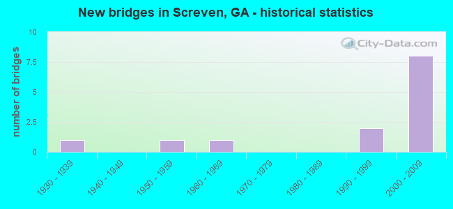
- New bridges - historical statistics
- 11930-1939
- 11950-1959
- 11960-1969
- 21990-1999
- 82000-2009

- Reconstructed bridges - Historical Statistics
- 11990-1999
- 12000-2009


- Bridge Condition - Deck
- 91.7%Good
- 8.3%Satisfactory

- Bridge Condition - Superstructure
- 91.7%Good
- 8.3%Satisfactory

- Bridge Condition - Substructure
- 8.3%Very good
- 91.7%Good

- Bridge Condition - Channel
- 15.4%Excellent
- 46.2%Very good
- 30.8%Good
- 7.7%Satisfactory
Find on map >> Show street view
Structure Number: 2295028, Location: 7 MI NE OF PATTERSON (Lat: 31.451908, Lng: -82.062569), Route carried "on" structure: US 84, Year Built: 2004, Status: Open, Structure Length: 7.50m (24.61ft), Average Daily Traffic: 4,310 (year 2012), Truck Traffic: 1%, Average Future Daily Traffic: 6,465 (year 2032), Design Load: HS 20+Mod, Features Intersected: BIG SATILLA CREEK O/F
Minimum Vertical Clearance: 30+ m (98+ ft), Kilometerpoint: 33.796, Lanes on structure: 2, Base Highway Network: Yes, Owner: State Highway Agency, Approaching Roadway Width: 9.4m (30.8ft), Skew: 10 degrees, Material/Design: Concrete, Design/Construction: Tee Beam, Number Of Spans In Main Unit: 7, Length of Maximum Span: 11.0m (36.1ft), Curb-To-Curb Width: 11.4m (37.4ft), Out-to-Out Width: 12.4m (40.7ft)
Condition: Deck: Good, Superstructure: Good, Substructure: Good, Channel: Very good, Operating Rating: 69.8 metric tons, Method Used To Determine Operating Rating: Allowable Stress (AS), Inventory Rating: 41.7 metric tons, Method Used To Determine Inventory Rating: Allowable Stress (AS), Structural Evaluation: Better than present minimum criteria, Deck Geometry: Equal to present minimum criteria, Waterway Adequacy: Equal to present desirable criteria, Approach Roadway Alignment: Equal to present desirable criteria, Designated Inspection Frequency: Every 24 months, Inspection Date: August 2021, Bridge Improvement Cost: $961,000, Roadway Improvement Cost: $96,000, Total Project Cost: $1,442,000, Deck Structure Type: Concrete Cast-file-Place
Find on map >> Show street view
Structure Number: 2295029, Location: 7.5 MI NE OF PATTERSON (Lat: 31.457039, Lng: -82.056658), Route carried "on" structure: US 84, Year Built: 2004, Status: Open, Structure Length: 18.29m (60.01ft), Average Daily Traffic: 4,310 (year 2012), Truck Traffic: 1%, Average Future Daily Traffic: 6,465 (year 2032), Design Load: HS 20+Mod, Features Intersected: LITTLE SATILLA RIVER
Minimum Vertical Clearance: 30+ m (98+ ft), Kilometerpoint: 35.406, Lanes on structure: 2, Base Highway Network: Yes, Owner: State Highway Agency, Approaching Roadway Width: 9.1m (29.9ft), Skew: 10 degrees, Material/Design: Concrete, Design/Construction: Tee Beam, Number Of Spans In Main Unit: 15, Length of Maximum Span: 12.2m (40.0ft), Curb-To-Curb Width: 11.4m (37.4ft), Out-to-Out Width: 12.4m (40.7ft)
Condition: Deck: Good, Superstructure: Good, Substructure: Good, Channel: Excellent, Operating Rating: 64.4 metric tons, Method Used To Determine Operating Rating: Allowable Stress (AS), Inventory Rating: 39.0 metric tons, Method Used To Determine Inventory Rating: Allowable Stress (AS), Structural Evaluation: Better than present minimum criteria, Deck Geometry: Equal to present minimum criteria, Waterway Adequacy: Equal to present desirable criteria, Approach Roadway Alignment: Equal to present desirable criteria, Designated Inspection Frequency: Every 24 months, Underwater Inspection Frequency: Every 60 months, Inspection Date: August 2021, Underwater Inspection Date: March 2019, Bridge Improvement Cost: $2,344,000, Roadway Improvement Cost: $234,000, Total Project Cost: $3,516,000, Deck Structure Type: Concrete Cast-file-Place
Find on map >> Show street view
Structure Number: 229503, Location: 7 MI NE OF PATTERSON (Lat: 31.451781, Lng: -82.062417), Route carried "on" structure: US 84, Year Built: 2005, Status: Open, Structure Length: 7.50m (24.61ft), Average Daily Traffic: 4,310 (year 2012), Truck Traffic: 1%, Average Future Daily Traffic: 6,465 (year 2032), Design Load: HS 20+Mod, Features Intersected: BIF SATILLA CREEK O/F
Minimum Vertical Clearance: 30+ m (98+ ft), Kilometerpoint: 33.796, Lanes on structure: 2, Base Highway Network: Yes, Owner: State Highway Agency, Approaching Roadway Width: 9.8m (32.2ft), Skew: 10 degrees, Material/Design: Concrete, Design/Construction: Tee Beam, Number Of Spans In Main Unit: 7, Length of Maximum Span: 11.0m (36.1ft), Curb-To-Curb Width: 11.4m (37.4ft), Out-to-Out Width: 12.3m (40.4ft)
Condition: Deck: Good, Superstructure: Good, Substructure: Good, Channel: Very good, Operating Rating: 69.8 metric tons, Method Used To Determine Operating Rating: Allowable Stress (AS), Inventory Rating: 41.7 metric tons, Method Used To Determine Inventory Rating: Allowable Stress (AS), Structural Evaluation: Better than present minimum criteria, Deck Geometry: Equal to present minimum criteria, Waterway Adequacy: Equal to present desirable criteria, Approach Roadway Alignment: Equal to present desirable criteria, Designated Inspection Frequency: Every 24 months, Inspection Date: August 2021, Bridge Improvement Cost: $961,000, Roadway Improvement Cost: $96,000, Total Project Cost: $1,442,000, Deck Structure Type: Concrete Cast-file-Place
Find on map >> Show street view
Structure Number: 2295031, Location: 7.5 MI NE OF PATTERSON (Lat: 31.456908, Lng: -82.056489), Route carried "on" structure: US 84, Year Built: 2005, Status: Open, Structure Length: 18.29m (60.01ft), Average Daily Traffic: 4,310 (year 2012), Truck Traffic: 1%, Average Future Daily Traffic: 6,465 (year 2032), Design Load: HS 20+Mod, Features Intersected: LITTLE SATILLA RIVER
Minimum Vertical Clearance: 30+ m (98+ ft), Kilometerpoint: 35.406, Lanes on structure: 2, Base Highway Network: Yes, Owner: State Highway Agency, Approaching Roadway Width: 11.6m (38.1ft), Skew: 10 degrees, Material/Design: Concrete, Design/Construction: Tee Beam, Number Of Spans In Main Unit: 15, Length of Maximum Span: 12.2m (40.0ft), Curb-To-Curb Width: 11.4m (37.4ft), Out-to-Out Width: 12.3m (40.4ft)
Condition: Deck: Good, Superstructure: Good, Substructure: Good, Channel: Very good, Operating Rating: 64.4 metric tons, Method Used To Determine Operating Rating: Allowable Stress (AS), Inventory Rating: 39.0 metric tons, Method Used To Determine Inventory Rating: Allowable Stress (AS), Structural Evaluation: Better than present minimum criteria, Deck Geometry: Equal to present minimum criteria, Waterway Adequacy: Equal to present desirable criteria, Approach Roadway Alignment: Equal to present desirable criteria, Designated Inspection Frequency: Every 24 months, Underwater Inspection Frequency: Every 60 months, Inspection Date: July 2021, Underwater Inspection Date: March 2019, Bridge Improvement Cost: $2,344,000, Roadway Improvement Cost: $234,000, Total Project Cost: $3,516,000, Deck Structure Type: Concrete Cast-file-Place
Find on map >> Show street view
Structure Number: 3050016, Location: 1 MI SW OF SCREVEN (Lat: 31.474978, Lng: -82.032778), Route carried "on" structure: US 84, Year Built: 1932, Year Reconstructed: 2005, Status: Open, Structure Length: 1.04m (3.41ft), Average Daily Traffic: 4,650 (year 2011), Truck Traffic: 1%, Average Future Daily Traffic: 6,975 (year 2031), Design Load: H 15, Features Intersected: TIGER CREEK
Minimum Vertical Clearance: 30+ m (98+ ft), Kilometerpoint: 3.219, Lanes on structure: 5, Base Highway Network: Yes, Owner: State Highway Agency, Approaching Roadway Width: 22.6m (74.1ft), Material/Design: Concrete, Design/Construction: Culvert, Number Of Spans In Main Unit: 3, Length of Maximum Span: 3.0m (9.8ft)
Condition: Channel: Satisfactory, Culverts: Good, Operating Rating: 51.7 metric tons, Method Used To Determine Operating Rating: Load Factor (LF), Inventory Rating: 30.8 metric tons, Method Used To Determine Inventory Rating: Load Factor (LF), Structural Evaluation: Better than present minimum criteria, Waterway Adequacy: Equal to present desirable criteria, Approach Roadway Alignment: Equal to present desirable criteria, Length Of Structure Improvement: 7.77m (25.49ft), Designated Inspection Frequency: Every 24 months, Inspection Date: March 2021, Roadway Improvement Cost: $170,000, Total Project Cost: $190,000
Find on map >> Show street view
Structure Number: 3050026, Location: 1 MI N OF SCREVEN (Lat: 31.510578, Lng: -82.016808), Route carried "on" structure: County highway 605, Year Built: 1956, Year Reconstructed: 2003, Status: Open, Structure Length: 7.92m (25.98ft), Average Daily Traffic: 400 (year 2011), Truck Traffic: 1%, Average Future Daily Traffic: 600 (year 2031), Design Load: H 15, Features Intersected: LITTLE SATILLA CREEK, Facility Carried by Structure: ODUM SCREVEN RD.
Minimum Vertical Clearance: 30+ m (98+ ft), Kilometerpoint: 1.609, Lanes on structure: 2, Base Highway Network: Yes, Owner: County Highway Agency, Approaching Roadway Width: 5.8m (19.0ft), Material/Design: Prestressed concrete, Design/Construction: Channel Beam, Number Of Spans In Main Unit: 13, Length of Maximum Span: 6.1m (20.0ft), Curb-To-Curb Width: 7.1m (23.3ft), Out-to-Out Width: 7.7m (25.3ft)
Condition: Deck: Satisfactory, Superstructure: Satisfactory, Substructure: Good, Channel: Good, Operating Rating: 26.3 metric tons, Method Used To Determine Operating Rating: Allowable Stress (AS), Inventory Rating: 24.4 metric tons, Method Used To Determine Inventory Rating: Allowable Stress (AS), Structural Evaluation: Equal to present minimum criteria, Deck Geometry: Meets minimum limits, Waterway Adequacy: Equal to present desirable criteria, Approach Roadway Alignment: Equal to present desirable criteria, Length Of Structure Improvement: 14.48m (47.51ft), Designated Inspection Frequency: Every 24 months, Underwater Inspection Frequency: Every 60 months, Inspection Date: March 2021, Underwater Inspection Date: Febuary 2022, Bridge Improvement Cost: $289,000, Roadway Improvement Cost: $96,000, Total Project Cost: $473,000, Deck Structure Type: Concrete Precast Panels
Find on map >> Show street view
Structure Number: 3050031, Location: 1 MI W OF SCREVEN (Lat: 31.493658, Lng: -82.035108), Route carried "on" structure: County highway 1144, Year Built: 1994, Status: Open, Structure Length: 7.68m (25.20ft), Average Daily Traffic: 1,240 (year 2011), Truck Traffic: 1%, Average Future Daily Traffic: 1,860 (year 2031), Design Load: HS 20+Mod, Features Intersected: LITTLE SATILLA CREEK, Facility Carried by Structure: NINE RUN ROAD
Minimum Vertical Clearance: 30+ m (98+ ft), Kilometerpoint: 11.265, Lanes on structure: 2, Base Highway Network: Yes, Owner: County Highway Agency, Approaching Roadway Width: 7.3m (24.0ft), Material/Design: Concrete, Design/Construction: Tee Beam, Number Of Spans In Main Unit: 7, Length of Maximum Span: 11.0m (36.1ft), Curb-To-Curb Width: 9.8m (32.2ft), Out-to-Out Width: 10.8m (35.4ft)
Condition: Deck: Good, Superstructure: Good, Substructure: Good, Channel: Good, Operating Rating: 71.6 metric tons, Method Used To Determine Operating Rating: Load Factor (LF), Inventory Rating: 42.6 metric tons, Method Used To Determine Inventory Rating: Load Factor (LF), Structural Evaluation: Better than present minimum criteria, Deck Geometry: Somewhat better than minimum adequacy, Waterway Adequacy: Equal to present desirable criteria, Approach Roadway Alignment: Equal to present desirable criteria, Designated Inspection Frequency: Every 24 months, Underwater Inspection Frequency: Every 60 months, Inspection Date: March 2021, Underwater Inspection Date: Febuary 2022, Deck Structure Type: Concrete Cast-file-Place
Find on map >> Show street view
Structure Number: 3050032, Location: 1 MI W OF SCREVEN (Lat: 31.490369, Lng: -82.032219), Route carried "on" structure: County highway 1144, Year Built: 1994, Status: Open, Structure Length: 7.68m (25.20ft), Average Daily Traffic: 1,240 (year 2011), Truck Traffic: 1%, Average Future Daily Traffic: 1,860 (year 2031), Design Load: HS 20+Mod, Features Intersected: LITTLE SATILLA CREEK O/F, Facility Carried by Structure: NINE RUN ROAD
Minimum Vertical Clearance: 30+ m (98+ ft), Kilometerpoint: 11.265, Lanes on structure: 2, Base Highway Network: Yes, Owner: County Highway Agency, Approaching Roadway Width: 7.3m (24.0ft), Skew: 3 degrees, Material/Design: Concrete, Design/Construction: Tee Beam, Number Of Spans In Main Unit: 7, Length of Maximum Span: 11.0m (36.1ft), Curb-To-Curb Width: 9.8m (32.2ft), Out-to-Out Width: 10.8m (35.4ft)
Condition: Deck: Good, Superstructure: Good, Substructure: Good, Channel: Very good, Operating Rating: 68.9 metric tons, Method Used To Determine Operating Rating: Load Factor (LF), Inventory Rating: 41.7 metric tons, Method Used To Determine Inventory Rating: Load Factor (LF), Structural Evaluation: Better than present minimum criteria, Deck Geometry: Somewhat better than minimum adequacy, Waterway Adequacy: Equal to present desirable criteria, Approach Roadway Alignment: Equal to present desirable criteria, Designated Inspection Frequency: Every 24 months, Inspection Date: March 2021, Deck Structure Type: Concrete Cast-file-Place
Find on map >> Show street view
Structure Number: 3055026, Location: 3 MI W OF SCREVEN (Lat: 31.502419, Lng: -82.074700), Route carried "on" structure: County highway 190, Year Built: 1967, Status: Posted for load, Structure Length: 4.57m (14.99ft), Average Daily Traffic: 270 (year 2011), Truck Traffic: 1%, Average Future Daily Traffic: 405 (year 2031), Design Load: H 15, Features Intersected: REEDY CREEK, Facility Carried by Structure: STANFIELD ROAD
Minimum Vertical Clearance: 30+ m (98+ ft), Kilometerpoint: 3.219, Lanes on structure: 2, Base Highway Network: Yes, Owner: County Highway Agency, Approaching Roadway Width: 6.4m (21.0ft), Material/Design: Concrete, Design/Construction: Tee Beam, Number Of Spans In Main Unit: 5, Length of Maximum Span: 9.1m (29.9ft), Curb or Sidewalk Widths: Left: 0.6m (2.0ft), Right: 0.6m (2.0ft), Curb-To-Curb Width: 7.3m (24.0ft), Out-to-Out Width: 9.2m (30.2ft)
Condition: Deck: Good, Superstructure: Good, Substructure: Good, Channel: Good, Operating Rating: 31.7 metric tons, Method Used To Determine Operating Rating: Load Factor (LF), Inventory Rating: 19.0 metric tons, Method Used To Determine Inventory Rating: Load Factor (LF), Structural Evaluation: Somewhat better than minimum adequacy, Deck Geometry: Somewhat better than minimum adequacy, Waterway Adequacy: Better than present minimum criteria, Approach Roadway Alignment: Equal to present desirable criteria, Bridge Posting: Required (Relationship of Operating Rating to Maximum Legal Load: 0.1 - 9.9% below), Designated Inspection Frequency: Every 24 months, Underwater Inspection Frequency: Every 60 months, Inspection Date: March 2021, Underwater Inspection Date: Febuary 2022, Deck Structure Type: Concrete Cast-file-Place
Find on map >> Show street view
Structure Number: 3055045, Location: 2 MI W OF SCREVEN (Lat: 31.460469, Lng: -82.052703), Route carried "on" structure: US 84, Year Built: 2004, Status: Open, Structure Length: 6.34m (20.80ft), Average Daily Traffic: 4,650 (year 2011), Truck Traffic: 1%, Average Future Daily Traffic: 6,975 (year 2031), Design Load: HS 20+Mod, Features Intersected: LITTLE SATILLA CREEK
Minimum Vertical Clearance: 30+ m (98+ ft), Kilometerpoint: 0.000, Lanes on structure: 2, Base Highway Network: Yes, Owner: State Highway Agency, Approaching Roadway Width: 9.4m (30.8ft), Skew: 10 degrees, Material/Design: Concrete, Design/Construction: Tee Beam, Number Of Spans In Main Unit: 6, Length of Maximum Span: 11.0m (36.1ft), Curb-To-Curb Width: 11.4m (37.4ft), Out-to-Out Width: 12.4m (40.7ft)
Condition: Deck: Good, Superstructure: Good, Substructure: Good, Channel: Good, Operating Rating: 53.5 metric tons, Method Used To Determine Operating Rating: Allowable Stress (AS), Inventory Rating: 32.6 metric tons, Method Used To Determine Inventory Rating: Allowable Stress (AS), Structural Evaluation: Better than present minimum criteria, Deck Geometry: Equal to present minimum criteria, Waterway Adequacy: Equal to present desirable criteria, Approach Roadway Alignment: Equal to present desirable criteria, Designated Inspection Frequency: Every 24 months, Inspection Date: March 2021, Deck Structure Type: Concrete Cast-file-Place
Find on map >> Show street view
Structure Number: 3055046, Location: 2 MI W OF SCREVEN (Lat: 31.464300, Lng: -82.048319), Route carried "on" structure: US 84, Year Built: 2004, Status: Open, Structure Length: 6.34m (20.80ft), Average Daily Traffic: 4,650 (year 2011), Truck Traffic: 1%, Average Future Daily Traffic: 6,975 (year 2031), Design Load: HS 20+Mod, Features Intersected: LITTLE SATILLA CR. O/F
Minimum Vertical Clearance: 30+ m (98+ ft), Kilometerpoint: 1.609, Lanes on structure: 2, Base Highway Network: Yes, Owner: State Highway Agency, Approaching Roadway Width: 9.1m (29.9ft), Skew: 10 degrees, Material/Design: Concrete, Design/Construction: Tee Beam, Number Of Spans In Main Unit: 6, Length of Maximum Span: 11.0m (36.1ft), Curb-To-Curb Width: 11.4m (37.4ft), Out-to-Out Width: 12.4m (40.7ft)
Condition: Deck: Good, Superstructure: Good, Substructure: Good, Channel: Excellent, Operating Rating: 53.5 metric tons, Method Used To Determine Operating Rating: Allowable Stress (AS), Inventory Rating: 32.6 metric tons, Method Used To Determine Inventory Rating: Allowable Stress (AS), Structural Evaluation: Better than present minimum criteria, Deck Geometry: Equal to present minimum criteria, Waterway Adequacy: Equal to present desirable criteria, Approach Roadway Alignment: Equal to present desirable criteria, Designated Inspection Frequency: Every 24 months, Inspection Date: March 2021, Deck Structure Type: Concrete Cast-file-Place
Find on map >> Show street view
Structure Number: 3055048, Location: 2 MI SW OF SCREVEN (Lat: 31.460358, Lng: -82.052528), Route carried "on" structure: US 84, Year Built: 2005, Status: Open, Structure Length: 7.44m (24.41ft), Average Daily Traffic: 4,650 (year 2011), Truck Traffic: 1%, Average Future Daily Traffic: 6,975 (year 2031), Design Load: HS 20+Mod, Features Intersected: LITTLE SATILLA CREEK
Minimum Vertical Clearance: 30+ m (98+ ft), Kilometerpoint: 0.000, Lanes on structure: 2, Base Highway Network: Yes, Owner: State Highway Agency, Approaching Roadway Width: 10.1m (33.1ft), Skew: 10 degrees, Material/Design: Concrete, Design/Construction: Tee Beam, Number Of Spans In Main Unit: 6, Length of Maximum Span: 11.0m (36.1ft), Curb-To-Curb Width: 11.4m (37.4ft), Out-to-Out Width: 12.3m (40.4ft)
Condition: Deck: Good, Superstructure: Good, Substructure: Good, Channel: Very good, Operating Rating: 53.5 metric tons, Method Used To Determine Operating Rating: Allowable Stress (AS), Inventory Rating: 32.6 metric tons, Method Used To Determine Inventory Rating: Allowable Stress (AS), Structural Evaluation: Better than present minimum criteria, Deck Geometry: Equal to present minimum criteria, Waterway Adequacy: Equal to present desirable criteria, Approach Roadway Alignment: Equal to present desirable criteria, Designated Inspection Frequency: Every 24 months, Inspection Date: March 2021, Deck Structure Type: Concrete Cast-file-Place
Find on map >> Show street view
Structure Number: 3055049, Location: 2 MI SW OF SCREVEN (Lat: 31.464139, Lng: -82.048169), Route carried "on" structure: US 84, Year Built: 2005, Status: Open, Structure Length: 6.34m (20.80ft), Average Daily Traffic: 4,650 (year 2011), Truck Traffic: 1%, Average Future Daily Traffic: 6,975 (year 2031), Design Load: HS 20+Mod, Features Intersected: LITTLE SATILLA CREEK
Minimum Vertical Clearance: 30+ m (98+ ft), Kilometerpoint: 1.609, Lanes on structure: 2, Base Highway Network: Yes, Owner: State Highway Agency, Approaching Roadway Width: 10.1m (33.1ft), Skew: 10 degrees, Material/Design: Concrete, Design/Construction: Tee Beam, Number Of Spans In Main Unit: 6, Length of Maximum Span: 11.0m (36.1ft), Curb-To-Curb Width: 11.4m (37.4ft), Out-to-Out Width: 12.3m (40.4ft)
Condition: Deck: Good, Superstructure: Good, Substructure: Very good, Channel: Very good, Operating Rating: 53.5 metric tons, Method Used To Determine Operating Rating: Allowable Stress (AS), Inventory Rating: 32.6 metric tons, Method Used To Determine Inventory Rating: Allowable Stress (AS), Structural Evaluation: Better than present minimum criteria, Deck Geometry: Equal to present minimum criteria, Waterway Adequacy: Equal to present desirable criteria, Approach Roadway Alignment: Equal to present desirable criteria, Designated Inspection Frequency: Every 24 months, Inspection Date: March 2021, Deck Structure Type: Concrete Cast-file-Place