Bridge Statistics for Silt, Colorado (CO)
Condition, Traffic, Stress, Structural Evaluation, Project Costs
- National Bridge Inventory (NBI) Statistics
- 11Number of bridges
- 187ft / 57.3mTotal length
- $491,000Total costs
- 93,405Total average daily traffic
- 12,530Total average daily truck traffic
- National Bridge Inventory (NBI) Registered Bridges for Silt
- No street view available for this location
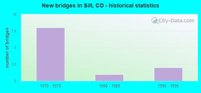
- New bridges - historical statistics
- 81970-1979
- 11980-1989
- 21990-1999


- Bridge Condition - Deck
- 12.5%Good
- 62.5%Satisfactory
- 25.0%Fair

- Bridge Condition - Superstructure
- 25.0%Very good
- 25.0%Good
- 37.5%Satisfactory
- 12.5%Fair

- Bridge Condition - Substructure
- 62.5%Good
- 37.5%Satisfactory

- Bridge Condition - Channel
- 20.0%Very good
- 40.0%Good
- 40.0%Satisfactory
Find on map >> Show street view
Structure Number: F-06-S, Location: 4.5 mil. W. of New Castle (Lat: 39.551706, Lng: -107.593867), Route carried "on" structure: County highway , Year Built: 1972, Status: Open, Structure Length: 6.06m (19.88ft), Average Daily Traffic: 1,000 (year 2013), Truck Traffic: 1%, Average Future Daily Traffic: 2,000 (year 2033), Design Load: HS 20+Mod, Features Intersected: I 70 ML, Facility Carried by Structure: COUNTY ROAD 262
Minimum Vertical Clearance: 5.11m (16.77ft), Kilometerpoint: 0.084, Lanes on structure: 2, Lanes under structure: 4, Owner: State Highway Agency, Approaching Roadway Width: 7.6m (24.9ft), Material/Design: Steel continuous, Design/Construction: Stringer/Multi-beam, Number Of Spans In Main Unit: 2, Length of Maximum Span: 29.6m (97.1ft), Curb-To-Curb Width: 7.6m (24.9ft), Out-to-Out Width: 8.4m (27.6ft)
Condition: Deck: Fair, Superstructure: Good, Substructure: Satisfactory, Operating Rating: 49.1 metric tons, Method Used To Determine Operating Rating: Load Factor (LF), Inventory Rating: 29.4 metric tons, Method Used To Determine Inventory Rating: Load Factor (LF), Structural Evaluation: Equal to present minimum criteria, Deck Geometry: Meets minimum limits, Underclear: Superior to present desirable criteria, Approach Roadway Alignment: Equal to present desirable criteria, Designated Inspection Frequency: Every 24 months, Inspection Date: July 2020, Deck Structure Type: Concrete Cast-file-Place, Wearing Surface/Protective System: Wearing Surface: Bituminous
Find on map >> Show street view
Structure Number: F-06-T, Location: IN SILT (Lat: 39.545997, Lng: -107.653683), Route carried "on" structure: Spur State highway 70E, Year Built: 1972, Status: Open, Structure Length: 4.54m (14.90ft), Average Daily Traffic: 9,800 (year 2020), Truck Traffic: 5%, Average Future Daily Traffic: 11,662 (year 2040), Design Load: HS 20+Mod, Features Intersected: UP RR, Facility Carried by Structure: I 70 SILT SPUR
Minimum Vertical Clearance: 30+ m (98+ ft), Kilometerpoint: 0.232, Lanes on structure: 2, Owner: State Highway Agency, Approaching Roadway Width: 7.9m (25.9ft), Material/Design: Steel continuous, Design/Construction: Stringer/Multi-beam, Number Of Spans In Main Unit: 3, Length of Maximum Span: 20.4m (66.9ft), Curb-To-Curb Width: 8.5m (27.9ft), Out-to-Out Width: 9.3m (30.5ft)
Condition: Deck: Fair, Superstructure: Satisfactory, Substructure: Good, Operating Rating: 48.8 metric tons, Method Used To Determine Operating Rating: Load Factor (LF), Inventory Rating: 29.2 metric tons, Method Used To Determine Inventory Rating: Load Factor (LF), Structural Evaluation: Equal to present minimum criteria, Deck Geometry: High priority of replacement, Underclear: Equal to present minimum criteria, Approach Roadway Alignment: Equal to present desirable criteria, Length Of Structure Improvement: 4.54m (14.90ft), Designated Inspection Frequency: Every 24 months, Inspection Date: July 2020, Bridge Improvement Cost: $327,000, Roadway Improvement Cost: $33,000, Total Project Cost: $491,000, Deck Structure Type: Concrete Cast-file-Place, Wearing Surface/Protective System: Wearing Surface: Bituminous
Find on map >> Show street view
Structure Number: F-06-U, Location: NEAR SILT (Lat: 39.545097, Lng: -107.653836), Route carried "on" structure: Spur State highway 70E, Year Built: 1972, Status: Open, Structure Length: 6.67m (21.88ft), Average Daily Traffic: 9,800 (year 2020), Truck Traffic: 5%, Average Future Daily Traffic: 11,662 (year 2040), Design Load: HS 20+Mod, Features Intersected: I 70 ML, Facility Carried by Structure: I 70 SILT SPUR
Minimum Vertical Clearance: 30+ m (98+ ft), Kilometerpoint: 0.132, Lanes on structure: 2, Lanes under structure: 4, Owner: State Highway Agency, Approaching Roadway Width: 8.5m (27.9ft), Material/Design: Steel continuous, Design/Construction: Stringer/Multi-beam, Number Of Spans In Main Unit: 2, Length of Maximum Span: 32.8m (107.6ft), Curb-To-Curb Width: 8.5m (27.9ft), Out-to-Out Width: 9.3m (30.5ft)
Condition: Deck: Satisfactory, Superstructure: Satisfactory, Substructure: Good, Operating Rating: 50.9 metric tons, Method Used To Determine Operating Rating: Load Factor (LF), Inventory Rating: 30.5 metric tons, Method Used To Determine Inventory Rating: Load Factor (LF), Structural Evaluation: Equal to present minimum criteria, Deck Geometry: Meets minimum limits, Underclear: Somewhat better than minimum adequacy, Approach Roadway Alignment: Equal to present desirable criteria, Designated Inspection Frequency: Every 24 months, Inspection Date: July 2020, Deck Structure Type: Concrete Cast-file-Place, Wearing Surface/Protective System: Wearing Surface: Bituminous
Find on map >> Show street view
Structure Number: F-06-Y, Location: 1 MI W OF SILT (Lat: 39.542636, Lng: -107.673211), Route carried "on" structure: Interstate 70A, Year Built: 1975, Status: Open, Structure Length: 13.54m (44.42ft), Average Daily Traffic: 10,500 (year 2020), Truck Traffic: 11%, Average Future Daily Traffic: 13,965 (year 2040), Design Load: HS 20+Mod, Features Intersected: COLORADO RIVER, Facility Carried by Structure: I 70 ML EBND
Minimum Vertical Clearance: 30+ m (98+ ft), Kilometerpoint: 155.228, Lanes on structure: 2, Base Highway Network: Yes, Owner: State Highway Agency, Approaching Roadway Width: 11.6m (38.1ft), Skew: 12 degrees, Material/Design: Steel continuous, Design/Construction: Stringer/Multi-beam, Number Of Spans In Main Unit: 5, Length of Maximum Span: 30.0m (98.4ft), Curb-To-Curb Width: 12.8m (42.0ft), Out-to-Out Width: 13.6m (44.6ft)
Condition: Deck: Satisfactory, Superstructure: Satisfactory, Substructure: Good, Channel: Satisfactory, Operating Rating: 56.5 metric tons, Method Used To Determine Operating Rating: Load Factor (LF), Inventory Rating: 33.8 metric tons, Method Used To Determine Inventory Rating: Load Factor (LF), Structural Evaluation: Equal to present minimum criteria, Deck Geometry: Equal to present desirable criteria, Waterway Adequacy: Equal to present desirable criteria, Approach Roadway Alignment: Equal to present desirable criteria, Designated Inspection Frequency: Every 24 months, Underwater Inspection Frequency: Every 60 months, Inspection Date: October 2020, Underwater Inspection Date: August 2020, Deck Structure Type: Concrete Cast-file-Place, Wearing Surface/Protective System: Wearing Surface: Epoxy Overlay
Find on map >> Show street view
Structure Number: F-06-Z, Location: 1.1 MI W OF SILT SPUR (Lat: 39.542856, Lng: -107.673606), Route carried "on" structure: Interstate 70A, Year Built: 1975, Status: Open, Structure Length: 13.54m (44.42ft), Average Daily Traffic: 10,500 (year 2020), Truck Traffic: 11%, Average Future Daily Traffic: 13,965 (year 2040), Design Load: HS 20+Mod, Features Intersected: COLORADO RIVER, Facility Carried by Structure: I 70 ML WBND
Minimum Vertical Clearance: 30+ m (98+ ft), Kilometerpoint: 155.213, Lanes on structure: 2, Base Highway Network: Yes, Owner: State Highway Agency, Approaching Roadway Width: 11.6m (38.1ft), Skew: 12 degrees, Material/Design: Steel continuous, Design/Construction: Stringer/Multi-beam, Number Of Spans In Main Unit: 5, Length of Maximum Span: 30.5m (100.1ft), Curb-To-Curb Width: 12.8m (42.0ft), Out-to-Out Width: 13.6m (44.6ft)
Condition: Deck: Satisfactory, Superstructure: Fair, Substructure: Satisfactory, Channel: Very good, Operating Rating: 56.7 metric tons, Method Used To Determine Operating Rating: Load Factor (LF), Inventory Rating: 34.0 metric tons, Method Used To Determine Inventory Rating: Load Factor (LF), Structural Evaluation: Somewhat better than minimum adequacy, Deck Geometry: Equal to present desirable criteria, Waterway Adequacy: Equal to present desirable criteria, Approach Roadway Alignment: Equal to present desirable criteria, Designated Inspection Frequency: Every 24 months, Underwater Inspection Frequency: Every 60 months, Inspection Date: October 2020, Underwater Inspection Date: August 2020, Deck Structure Type: Concrete Cast-file-Place, Wearing Surface/Protective System: Wearing Surface: Epoxy Overlay
Find on map >> Show street view
Structure Number: GAR311-10.95-A, Location: 1.8 Mi SE of I-70 (Lat: 39.540417, Lng: -107.622944), Route carried "on" structure: County highway , Year Built: 1990, Status: Open, Structure Length: 1.27m (4.17ft), Average Daily Traffic: 1,278 (year 2020), Truck Traffic: 32%, Average Future Daily Traffic: 1,623 (year 2040), Design Load: HS 20, Features Intersected: Divide Creek, Facility Carried by Structure: Divide Creek Road
Minimum Vertical Clearance: 30+ m (98+ ft), Kilometerpoint: 2.052, Lanes on structure: 2, Owner: County Highway Agency, Approaching Roadway Width: 7.3m (24.0ft), Material/Design: Steel, Design/Construction: Stringer/Multi-beam, Number Of Spans In Main Unit: 1, Length of Maximum Span: 11.6m (38.1ft), Curb-To-Curb Width: 8.5m (27.9ft), Out-to-Out Width: 9.3m (30.5ft)
Condition: Deck: Good, Superstructure: Very good, Substructure: Good, Channel: Good, Operating Rating: 59.2 metric tons, Method Used To Determine Operating Rating: Load Factor (LF), Inventory Rating: 35.5 metric tons, Method Used To Determine Inventory Rating: Load Factor (LF), Structural Evaluation: Better than present minimum criteria, Deck Geometry: Somewhat better than minimum adequacy, Waterway Adequacy: Equal to present desirable criteria, Approach Roadway Alignment: Equal to present minimum criteria, Designated Inspection Frequency: Every 24 months, Inspection Date: September 2021, Deck Structure Type: Concrete Cast-file-Place, Wearing Surface/Protective System: Wearing Surface: Bituminous, Membrane: Built-up, Deck Protection: Epoxy Coated Reinforcing
Find on map >> Show street view
Structure Number: GAR311-12.54-A, Location: 0.7 Mi S of I-70 Fr. Rd. (Lat: 39.539056, Lng: -107.645833), Route carried "on" structure: County highway , Year Built: 1993, Status: Open, Structure Length: 3.66m (12.01ft), Average Daily Traffic: 3,601 (year 2020), Truck Traffic: 44%, Average Future Daily Traffic: 4,573 (year 2040), Design Load: HS 20, Features Intersected: Colorado River, Facility Carried by Structure: County Road 311
Minimum Vertical Clearance: 30+ m (98+ ft), Kilometerpoint: 0.369, Lanes on structure: 2, Owner: County Highway Agency, Approaching Roadway Width: 8.5m (27.9ft), Material/Design: Prestressed concrete, Design/Construction: Stringer/Multi-beam, Number Of Spans In Main Unit: 1, Length of Maximum Span: 35.1m (115.2ft), Curb or Sidewalk Widths: Left: 1.2m (3.9ft), Right: 0.0m, Curb-To-Curb Width: 8.8m (28.9ft), Out-to-Out Width: 10.8m (35.4ft)
Condition: Deck: Satisfactory, Superstructure: Very good, Substructure: Good, Channel: Satisfactory, Operating Rating: 53.9 metric tons, Method Used To Determine Operating Rating: Load Factor (LF), Inventory Rating: 30.7 metric tons, Method Used To Determine Inventory Rating: Load Factor (LF), Structural Evaluation: Better than present minimum criteria, Deck Geometry: Meets minimum limits, Waterway Adequacy: Equal to present desirable criteria, Approach Roadway Alignment: Equal to present desirable criteria, Designated Inspection Frequency: Every 24 months, Underwater Inspection Frequency: Every 60 months, Inspection Date: September 2021, Underwater Inspection Date: August 2020, Deck Structure Type: Concrete Cast-file-Place, Wearing Surface/Protective System: Wearing Surface: Monolithic Concrete, Deck Protection: Epoxy Coated Reinforcing
Find on map >> Show street view
Structure Number: GAR311-12.69, Location: 0.2 Miles South of I-70 (Lat: 39.542056, Lng: -107.646083), Route carried "on" structure: County highway , Year Built: 1983, Status: Open, Structure Length: 7.98m (26.18ft), Average Daily Traffic: 3,926 (year 2020), Truck Traffic: 42%, Average Future Daily Traffic: 4,986 (year 2040), Design Load: HS 20, Features Intersected: Colorado River, Facility Carried by Structure: County Road 311
Minimum Vertical Clearance: 30+ m (98+ ft), Kilometerpoint: 0.002, Lanes on structure: 2, Owner: County Highway Agency, Approaching Roadway Width: 8.5m (27.9ft), Material/Design: Prestressed concrete continuous, Design/Construction: Stringer/Multi-beam, Number Of Spans In Main Unit: 2, Length of Maximum Span: 38.6m (126.6ft), Curb or Sidewalk Widths: Left: 0.8m (2.6ft), Right: 0.0m, Curb-To-Curb Width: 8.6m (28.2ft), Out-to-Out Width: 10.2m (33.5ft)
Condition: Deck: Satisfactory, Superstructure: Good, Substructure: Satisfactory, Channel: Good, Operating Rating: 63.6 metric tons, Method Used To Determine Operating Rating: Load Factor (LF), Inventory Rating: 16.3 metric tons, Method Used To Determine Inventory Rating: Load Factor (LF), Structural Evaluation: Meets minimum limits, Deck Geometry: Meets minimum limits, Waterway Adequacy: Equal to present desirable criteria, Approach Roadway Alignment: Equal to present desirable criteria, Designated Inspection Frequency: Every 24 months, Underwater Inspection Frequency: Every 60 months, Inspection Date: September 2021, Underwater Inspection Date: August 2020, Deck Structure Type: Concrete Cast-file-Place, Wearing Surface/Protective System: Wearing Surface: Monolithic Concrete
Find on map >> Show street view
Structure Number: F-06-S, Location: 4.5 mil. W. of New Castle (Lat: 39.551706, Lng: -107.593867), Route carried "under" structure: Interstate 70A, Year Built: 1972, Structure Length: 0. m, Average Daily Traffic: 25,000 (year 2018), Truck Traffic: 13%, Features Intersected: I 70 ML, Facility Carried by Structure: COUNTY ROAD 262
Minimum Vertical Clearance: 5.39m (17.68ft), Kilometerpoint: 0.084, Lanes on structure: 2, Lanes under structure: 4, Material/Design: Steel continuous, Design/Construction: Stringer/Multi-beam, Length of Maximum Span: 29.6m (97.1ft)
Find on map >> Show street view
Structure Number: F-06-T, Location: IN SILT (Lat: 39.545997, Lng: -107.653683), Route carried "under" structure: Other road , Year Built: 1972, Structure Length: 0. m, Features Intersected: UP RR, Facility Carried by Structure: I 70 SILT SPUR
Minimum Vertical Clearance: 6.96m (22.83ft), Kilometerpoint: 0.000, Lanes on structure: 2, Material/Design: Steel continuous, Design/Construction: Stringer/Multi-beam, Length of Maximum Span: 20.4m (66.9ft)
Find on map >> Show street view
Structure Number: F-06-U, Location: NEAR SILT (Lat: 39.545097, Lng: -107.653836), Route carried "under" structure: Interstate 70A, Year Built: 1972, Structure Length: 0. m, Average Daily Traffic: 18,000 (year 2011), Truck Traffic: 13%, Features Intersected: I 70 ML, Facility Carried by Structure: I 70 SILT SPUR
Minimum Vertical Clearance: 5.33m (17.49ft), Kilometerpoint: 156.760, Lanes on structure: 2, Lanes under structure: 4, Material/Design: Steel continuous, Design/Construction: Stringer/Multi-beam, Length of Maximum Span: 32.8m (107.6ft)