Bridge Statistics for Somers, New York (NY)
Condition, Traffic, Stress, Structural Evaluation, Project Costs
- National Bridge Inventory (NBI) Statistics
- 15Number of bridges
- 174ft / 53.3mTotal length
- $56,045,000Total costs
- 115,735Total average daily traffic
- 6,167Total average daily truck traffic
- 131,817Total future (year 2035) average daily traffic
- National Bridge Inventory (NBI) Registered Bridges for Somers
- No street view available for this location
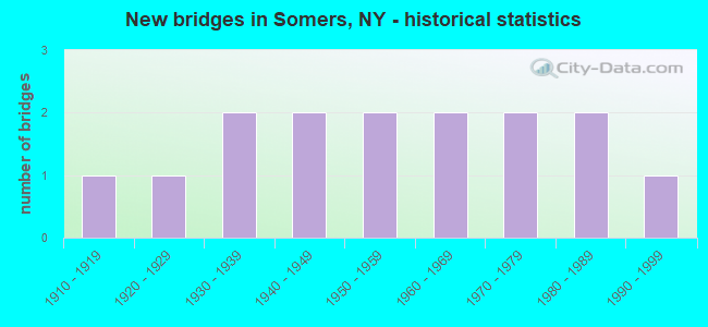
- New bridges - historical statistics
- 11910-1919
- 11920-1929
- 21930-1939
- 21940-1949
- 21950-1959
- 21960-1969
- 21970-1979
- 21980-1989
- 11990-1999

- Reconstructed bridges - Historical Statistics
- 11970-1979
- 21980-1989
- 11990-1999
- 12000-2009


- Bridge Condition - Deck
- 54.5%Good
- 27.3%Satisfactory
- 18.2%Fair

- Bridge Condition - Superstructure
- 7.7%Very good
- 7.7%Good
- 61.5%Satisfactory
- 23.1%Fair

- Bridge Condition - Substructure
- 15.4%Good
- 38.5%Satisfactory
- 46.2%Fair

- Bridge Condition - Channel
- 28.6%Very good
- 21.4%Good
- 35.7%Satisfactory
- 14.3%Fair
Find on map >> Show street view
Structure Number: 100345, Location: 2.8 MI E JCT RTE 6+TSP (Lat: 41.338164, Lng: -73.768983), Route carried "on" structure: US 6, Year Built: 1932, Status: Open, Structure Length: 0.88m (2.89ft), Average Daily Traffic: 18,404 (year 2018), Truck Traffic: 6%, Average Future Daily Traffic: 18,490 (year 2040), Design Load: HS 20, Features Intersected: MUSCOOT RIVER
Minimum Vertical Clearance: 30+ m (98+ ft), Kilometerpoint: 22.960, Lanes on structure: 2, Base Highway Network: Yes, Owner: State Highway Agency, Approaching Roadway Width: 11.6m (38.1ft), Skew: 2 degrees, Material/Design: Concrete, Design/Construction: Slab, Number Of Spans In Main Unit: 1, Length of Maximum Span: 7.6m (24.9ft), Curb-To-Curb Width: 10.7m (35.1ft), Out-to-Out Width: 11.5m (37.7ft)
Condition: Deck: Satisfactory, Superstructure: Satisfactory, Substructure: Satisfactory, Channel: Satisfactory, Operating Rating: 68.9 metric tons, Method Used To Determine Operating Rating: Load Factor (LF), Inventory Rating: 40.8 metric tons, Method Used To Determine Inventory Rating: Load Factor (LF), Structural Evaluation: Equal to present minimum criteria, Deck Geometry: Meets minimum limits, Waterway Adequacy: Meets minimum limits, Approach Roadway Alignment: Equal to present desirable criteria, Length Of Structure Improvement: 0.88m (2.89ft), Designated Inspection Frequency: Every 24 months, Inspection Date: September 2020, Bridge Improvement Cost: $519,000, Roadway Improvement Cost: $304,000, Total Project Cost: $823,000 ( Estimate for 2021), Wearing Surface/Protective System: Wearing Surface: Bituminous
Find on map >> Show street view
Structure Number: 102341, Location: 0.6 MI E JCT RTES 35+100 (Lat: 41.268939, Lng: -73.699628), Route carried "on" structure: State highway 35, Year Built: 1989, Status: Open, Structure Length: 8.60m (28.22ft), Average Daily Traffic: 21,345 (year 2017), Truck Traffic: 5%, Average Future Daily Traffic: 21,445 (year 2040), Design Load: HS 20, Features Intersected: MUSCOOT RESERVOIR
Minimum Vertical Clearance: 30+ m (98+ ft), Kilometerpoint: 23.186, Lanes on structure: 4, Base Highway Network: Yes, Owner: State Highway Agency, Approaching Roadway Width: 18.6m (61.0ft), Skew: 20 degrees, Material/Design: Steel continuous, Design/Construction: Stringer/Multi-beam, Number Of Spans In Main Unit: 3, Length of Maximum Span: 32.9m (107.9ft), Curb-To-Curb Width: 19.9m (65.3ft), Out-to-Out Width: 20.5m (67.3ft)
Condition: Deck: Satisfactory, Superstructure: Fair, Substructure: Fair, Channel: Very good, Inventory Rating: 79.8 metric tons, Method Used To Determine Inventory Rating: Load Factor (LF), Structural Evaluation: Somewhat better than minimum adequacy, Deck Geometry: Better than present minimum criteria, Waterway Adequacy: Equal to present minimum criteria, Approach Roadway Alignment: Equal to present desirable criteria, Length Of Structure Improvement: 8.59m (28.18ft), Designated Inspection Frequency: Every 24 months, Inspection Date: June 2021, Bridge Improvement Cost: $7,157,000, Roadway Improvement Cost: $4,191,000, Total Project Cost: $11,349,000 ( Estimate for 2021), Deck Structure Type: Concrete Cast-file-Place, Wearing Surface/Protective System: Wearing Surface: Monolithic Concrete, Deck Protection: Epoxy Coated Reinforcing
Find on map >> Show street view
Structure Number: 103615, Location: 1.2 MI N JCT RTS 100+35 (Lat: 41.271631, Lng: -73.712750), Route carried "on" structure: State highway 100, Year Built: 1966, Year Reconstructed: 1993, Status: Open, Structure Length: 3.99m (13.09ft), Average Daily Traffic: 9,150 (year 2016), Truck Traffic: 8%, Average Future Daily Traffic: 11,115 (year 2040), Design Load: H 20, Features Intersected: MUSCOOT RESERVOIR
Minimum Vertical Clearance: 30+ m (98+ ft), Kilometerpoint: 46.822, Lanes on structure: 2, Base Highway Network: Yes, Owner: State Highway Agency, Approaching Roadway Width: 13.4m (44.0ft), Material/Design: Steel, Design/Construction: Stringer/Multi-beam, Number Of Spans In Main Unit: 1, Length of Maximum Span: 38.7m (127.0ft), Curb-To-Curb Width: 11.6m (38.1ft), Out-to-Out Width: 12.2m (40.0ft)
Condition: Deck: Good, Superstructure: Good, Substructure: Good, Channel: Very good, Inventory Rating: 75.3 metric tons, Method Used To Determine Inventory Rating: Load Factor (LF), Structural Evaluation: Better than present minimum criteria, Deck Geometry: Somewhat better than minimum adequacy, Waterway Adequacy: Equal to present minimum criteria, Approach Roadway Alignment: Equal to present desirable criteria, Length Of Structure Improvement: 3.99m (13.09ft), Designated Inspection Frequency: Every 24 months, Inspection Date: July 2021, Bridge Improvement Cost: $2,181,000, Roadway Improvement Cost: $1,277,000, Total Project Cost: $3,459,000 ( Estimate for 2021), Deck Structure Type: Concrete Cast-file-Place, Wearing Surface/Protective System: Wearing Surface: Integral Concrete, Deck Protection: Epoxy Coated Reinforcing
Find on map >> Show street view
Structure Number: 103616, Location: 1 MI S JCT SH 100 & US202 (Lat: 41.304356, Lng: -73.698047), Route carried "on" structure: State highway 100, Year Built: 1949, Status: Open, Structure Length: 2.80m (9.19ft), Average Daily Traffic: 7,042 (year 2017), Truck Traffic: 7%, Average Future Daily Traffic: 8,554 (year 2040), Features Intersected: PLUM BROOK
Minimum Vertical Clearance: 30+ m (98+ ft), Kilometerpoint: 50.780, Lanes on structure: 3, Base Highway Network: Yes, Owner: State Highway Agency, Approaching Roadway Width: 14.6m (47.9ft), Material/Design: Steel, Design/Construction: Stringer/Multi-beam, Number Of Spans In Main Unit: 1, Length of Maximum Span: 27.4m (89.9ft), Curb-To-Curb Width: 14.6m (47.9ft), Out-to-Out Width: 17.0m (55.8ft)
Condition: Deck: Fair, Superstructure: Satisfactory, Substructure: Satisfactory, Channel: Very good, Operating Rating: 41.1 metric tons, Method Used To Determine Operating Rating: Load and Resistance Factor Rating (LRFR) rating reported by rating factor(RF) method using HL-93 loadings, Inventory Rating: 31.8 metric tons, Method Used To Determine Inventory Rating: Load and Resistance Factor Rating (LRFR) rating reported by rating factor(RF) method using HL-93 loadings, Structural Evaluation: Equal to present minimum criteria, Deck Geometry: Somewhat better than minimum adequacy, Waterway Adequacy: Equal to present minimum criteria, Approach Roadway Alignment: Meets minimum limits, Length Of Structure Improvement: 2.80m (9.19ft), Designated Inspection Frequency: Every 24 months, Critical Feature Inspection Frequency: Every 24 months, Inspection Date: August 2020, Critical Feature Inspection Date: August 2020, Bridge Improvement Cost: $1,708,000, Roadway Improvement Cost: $1,000,000, Total Project Cost: $2,709,000 ( Estimate for 2021), Deck Structure Type: Concrete Cast-file-Place, Wearing Surface/Protective System: Wearing Surface: Monolithic Concrete
Find on map >> Show street view
Structure Number: 103617, Location: 1.7 MI S JCT SH100 &US202 (Lat: 41.305700, Lng: -73.697075), Route carried "on" structure: State highway 100, Year Built: 1951, Status: Open, Structure Length: 4.75m (15.58ft), Average Daily Traffic: 7,042 (year 2017), Truck Traffic: 7%, Average Future Daily Traffic: 8,554 (year 2040), Design Load: H 20, Features Intersected: EX-NYCRR (PUTNAM)
Minimum Vertical Clearance: 30+ m (98+ ft), Kilometerpoint: 50.941, Lanes on structure: 3, Base Highway Network: Yes, Owner: State Highway Agency, Approaching Roadway Width: 14.6m (47.9ft), Skew: 3 degrees, Material/Design: Concrete continuous, Design/Construction: Tee Beam, Number Of Spans In Main Unit: 3, Length of Maximum Span: 18.2m (59.7ft), Curb or Sidewalk Widths: Left: 0.9m (3.0ft), Right: 0.9m (3.0ft), Curb-To-Curb Width: 14.6m (47.9ft), Out-to-Out Width: 17.1m (56.1ft)
Condition: Deck: Fair, Superstructure: Satisfactory, Substructure: Satisfactory, Operating Rating: 54.0 metric tons, Method Used To Determine Operating Rating: Field evaluation and documented engineering judgment, Inventory Rating: 22.6 metric tons, Method Used To Determine Inventory Rating: Field evaluation and documented engineering judgment, Structural Evaluation: Somewhat better than minimum adequacy, Deck Geometry: Somewhat better than minimum adequacy, Approach Roadway Alignment: Equal to present desirable criteria, Length Of Structure Improvement: 4.75m (15.58ft), Designated Inspection Frequency: Every 24 months, Inspection Date: June 2020, Bridge Improvement Cost: $3,388,000, Roadway Improvement Cost: $1,984,000, Total Project Cost: $5,373,000 ( Estimate for 2021), Deck Structure Type: Concrete Cast-file-Place, Wearing Surface/Protective System: Wearing Surface: Bituminous
Find on map >> Show street view
Structure Number: 103618, Location: .3 MI S JCT US 202 & SH22 (Lat: 41.348681, Lng: -73.667292), Route carried "on" structure: US 202, Year Built: 1937, Year Reconstructed: 1995, Status: Open, Structure Length: 2.01m (6.59ft), Average Daily Traffic: 8,886 (year 2019), Truck Traffic: 4%, Average Future Daily Traffic: 10,794 (year 2040), Design Load: HS 20, Features Intersected: W BR CROTON RIVER
Minimum Vertical Clearance: 30+ m (98+ ft), Kilometerpoint: 38.294, Lanes on structure: 2, Base Highway Network: Yes, Owner: State Highway Agency, Approaching Roadway Width: 14.3m (46.9ft), Skew: 2 degrees, Material/Design: Steel, Design/Construction: Stringer/Multi-beam, Number Of Spans In Main Unit: 1, Length of Maximum Span: 18.9m (62.0ft), Curb-To-Curb Width: 13.4m (44.0ft), Out-to-Out Width: 14.0m (45.9ft)
Condition: Deck: Good, Superstructure: Satisfactory, Substructure: Good, Channel: Satisfactory, Operating Rating: 62.5 metric tons, Method Used To Determine Operating Rating: Load and Resistance Factor Rating (LRFR) rating reported by rating factor(RF) method using HL-93 loadings, Inventory Rating: 48.3 metric tons, Method Used To Determine Inventory Rating: Load and Resistance Factor Rating (LRFR) rating reported by rating factor(RF) method using HL-93 loadings, Structural Evaluation: Equal to present minimum criteria, Deck Geometry: Equal to present minimum criteria, Waterway Adequacy: Somewhat better than minimum adequacy, Approach Roadway Alignment: Meets minimum limits, Length Of Structure Improvement: 2.01m (6.59ft), Designated Inspection Frequency: Every 24 months, Inspection Date: March 2021, Bridge Improvement Cost: $1,949,000, Roadway Improvement Cost: $1,141,000, Total Project Cost: $3,090,000 ( Estimate for 2021), Deck Structure Type: Concrete Cast-file-Place, Wearing Surface/Protective System: Wearing Surface: Integral Concrete, Deck Protection: Epoxy Coated Reinforcing
Find on map >> Show street view
Structure Number: 103619, Location: JCT RTS 100+202+22 (Lat: 41.352283, Lng: -73.663558), Route carried "on" structure: US 202, Year Built: 1928, Year Reconstructed: 1989, Status: Open, Structure Length: 2.74m (8.99ft), Average Daily Traffic: 8,886 (year 2019), Truck Traffic: 4%, Average Future Daily Traffic: 10,794 (year 2040), Design Load: HS 20, Features Intersected: EAST BRANCH CROTON RIVER
Minimum Vertical Clearance: 30+ m (98+ ft), Kilometerpoint: 38.793, Lanes on structure: 2, Base Highway Network: Yes, Owner: State Highway Agency, Approaching Roadway Width: 10.4m (34.1ft), Skew: 5 degrees, Material/Design: Steel, Design/Construction: Stringer/Multi-beam, Number Of Spans In Main Unit: 1, Length of Maximum Span: 25.9m (85.0ft), Curb-To-Curb Width: 10.7m (35.1ft), Out-to-Out Width: 11.0m (36.1ft)
Condition: Deck: Good, Superstructure: Fair, Substructure: Fair, Channel: Satisfactory, Operating Rating: 82.6 metric tons, Method Used To Determine Operating Rating: Load Factor (LF), Inventory Rating: 49.0 metric tons, Method Used To Determine Inventory Rating: Load Factor (LF), Structural Evaluation: Somewhat better than minimum adequacy, Deck Geometry: Meets minimum limits, Waterway Adequacy: Meets minimum limits, Approach Roadway Alignment: Equal to present desirable criteria, Length Of Structure Improvement: 2.74m (8.99ft), Designated Inspection Frequency: Every 24 months, Inspection Date: June 2021, Bridge Improvement Cost: $1,962,000, Roadway Improvement Cost: $1,149,000, Total Project Cost: $3,111,000 ( Estimate for 2021), Deck Structure Type: Concrete Cast-file-Place, Wearing Surface/Protective System: Wearing Surface: Integral Concrete
Find on map >> Show street view
Structure Number: 103709, Location: 0.2 MI W JCT RTS 116+I684 (Lat: 41.326619, Lng: -73.662472), Route carried "on" structure: State highway 116, Year Built: 1973, Status: Open, Structure Length: 8.69m (28.51ft), Average Daily Traffic: 4,823 (year 2014), Truck Traffic: 3%, Average Future Daily Traffic: 5,858 (year 2040), Design Load: HS 20, Features Intersected: CROTON RIVER
Minimum Vertical Clearance: 30+ m (98+ ft), Kilometerpoint: 1.738, Lanes on structure: 2, Base Highway Network: Yes, Owner: State Highway Agency, Approaching Roadway Width: 14.6m (47.9ft), Material/Design: Steel, Design/Construction: Stringer/Multi-beam, Number Of Spans In Main Unit: 2, Length of Maximum Span: 42.6m (139.8ft), Curb-To-Curb Width: 14.3m (46.9ft), Out-to-Out Width: 15.2m (49.9ft)
Condition: Deck: Good, Superstructure: Satisfactory, Substructure: Fair, Channel: Good, Operating Rating: 61.2 metric tons, Method Used To Determine Operating Rating: Load and Resistance Factor Rating (LRFR) rating reported by rating factor(RF) method using HL-93 loadings, Inventory Rating: 47.3 metric tons, Method Used To Determine Inventory Rating: Load and Resistance Factor Rating (LRFR) rating reported by rating factor(RF) method using HL-93 loadings, Structural Evaluation: Somewhat better than minimum adequacy, Deck Geometry: Superior to present desirable criteria, Waterway Adequacy: Equal to present minimum criteria, Approach Roadway Alignment: Equal to present desirable criteria, Length Of Structure Improvement: 8.68m (28.48ft), Designated Inspection Frequency: Every 24 months, Underwater Inspection Frequency: Every 60 months, Inspection Date: August 2020, Underwater Inspection Date: August 2018, Bridge Improvement Cost: $5,182,000, Roadway Improvement Cost: $3,035,000, Total Project Cost: $8,217,000 ( Estimate for 2021), Deck Structure Type: Concrete Cast-file-Place, Wearing Surface/Protective System: Wearing Surface: Integral Concrete
Find on map >> Show street view
Structure Number: 103797, Location: 0.3MI.W.JCT.RTES.138+684I (Lat: 41.297608, Lng: -73.681564), Route carried "on" structure: State highway 138, Year Built: 1986, Status: Open, Structure Length: 8.87m (29.10ft), Average Daily Traffic: 7,800 (year 2015), Truck Traffic: 4%, Average Future Daily Traffic: 9,650 (year 2040), Design Load: HS 20, Features Intersected: MUSCOOT RESERVOIR
Minimum Vertical Clearance: 30+ m (98+ ft), Kilometerpoint: 2.204, Lanes on structure: 4, Base Highway Network: Yes, Owner: State Highway Agency, Approaching Roadway Width: 15.8m (51.8ft), Material/Design: Steel continuous, Design/Construction: Stringer/Multi-beam, Number Of Spans In Main Unit: 3, Length of Maximum Span: 36.5m (119.8ft), Curb or Sidewalk Widths: Left: 0.0m, Right: 1.8m (5.9ft), Curb-To-Curb Width: 15.8m (51.8ft), Out-to-Out Width: 18.1m (59.4ft)
Condition: Deck: Satisfactory, Superstructure: Very good, Substructure: Fair, Channel: Very good, Operating Rating: 38.6 metric tons, Method Used To Determine Operating Rating: Load and Resistance Factor Rating (LRFR) rating reported by rating factor(RF) method using HL-93 loadings, Inventory Rating: 29.5 metric tons, Method Used To Determine Inventory Rating: Load and Resistance Factor Rating (LRFR) rating reported by rating factor(RF) method using HL-93 loadings, Structural Evaluation: Somewhat better than minimum adequacy, Deck Geometry: Meets minimum limits, Waterway Adequacy: Equal to present minimum criteria, Approach Roadway Alignment: Equal to present desirable criteria, Length Of Structure Improvement: 8.86m (29.07ft), Designated Inspection Frequency: Every 24 months, Underwater Inspection Frequency: Every 60 months, Inspection Date: July 2020, Underwater Inspection Date: July 2020, Bridge Improvement Cost: $6,204,000, Roadway Improvement Cost: $3,633,000, Total Project Cost: $9,838,000 ( Estimate for 2021), Deck Structure Type: Concrete Cast-file-Place, Wearing Surface/Protective System: Wearing Surface: Integral Concrete, Deck Protection: Epoxy Coated Reinforcing
Find on map >> Show street view
Structure Number: 334853, Location: AT AMAWALK (Lat: 41.285858, Lng: -73.765892), Route carried "on" structure: Other road , Year Built: 1955, Year Reconstructed: 2006, Status: Open, Structure Length: 1.52m (4.99ft), Average Daily Traffic: 1,692 (year 2018), Truck Traffic: 5%, Average Future Daily Traffic: 2,093 (year 2040), Features Intersected: MILL BROOK, Facility Carried by Structure: PINES BRIDGE ROAD
Minimum Vertical Clearance: 30+ m (98+ ft), Kilometerpoint: 4.473, Lanes on structure: 2, Owner: County Highway Agency, Approaching Roadway Width: 6.7m (22.0ft), Material/Design: Steel, Design/Construction: Culvert, Number Of Spans In Main Unit: 3, Length of Maximum Span: 3.9m (12.8ft)
Condition: Channel: Good, Culverts: Good, Operating Rating: 71.7 metric tons, Method Used To Determine Operating Rating: Field evaluation and documented engineering judgment, Inventory Rating: 19.6 metric tons, Method Used To Determine Inventory Rating: Field evaluation and documented engineering judgment, Structural Evaluation: Somewhat better than minimum adequacy, Waterway Adequacy: Somewhat better than minimum adequacy, Approach Roadway Alignment: Better than present minimum criteria, Length Of Structure Improvement: 1.52m (4.99ft), Designated Inspection Frequency: Every 24 months, Inspection Date: March 2021, Bridge Improvement Cost: $351,000, Roadway Improvement Cost: $205,000, Total Project Cost: $556,000 ( Estimate for 2021)
Find on map >> Show street view
Structure Number: 334854, Location: 1.5 MI SE OF AMAWALK (Lat: 41.272603, Lng: -73.745728), Route carried "on" structure: Other road , Year Built: 1940, Year Reconstructed: 1983, Status: Open, Structure Length: 0.91m (2.99ft), Average Daily Traffic: 560 (year 2017), Truck Traffic: 5%, Average Future Daily Traffic: 784 (year 2037), Design Load: HS 20, Features Intersected: MUSCOOT RIVER, Facility Carried by Structure: WOOD STREET
Minimum Vertical Clearance: 30+ m (98+ ft), Kilometerpoint: 1.689, Lanes on structure: 2, Owner: County Highway Agency, Approaching Roadway Width: 5.8m (19.0ft), Skew: 2 degrees, Material/Design: Prestressed concrete, Design/Construction: Box Beam or Girders - Multiple, Number Of Spans In Main Unit: 1, Length of Maximum Span: 8.2m (26.9ft), Curb-To-Curb Width: 5.8m (19.0ft), Out-to-Out Width: 6.4m (21.0ft)
Condition: Deck: Good, Superstructure: Satisfactory, Substructure: Fair, Channel: Satisfactory, Operating Rating: 50.2 metric tons, Method Used To Determine Operating Rating: Load and Resistance Factor Rating (LRFR) rating reported by rating factor(RF) method using HL-93 loadings, Inventory Rating: 36.6 metric tons, Method Used To Determine Inventory Rating: Load and Resistance Factor Rating (LRFR) rating reported by rating factor(RF) method using HL-93 loadings, Structural Evaluation: Somewhat better than minimum adequacy, Deck Geometry: High priority of replacement, Waterway Adequacy: Meets minimum limits, Approach Roadway Alignment: High priority of corrective action, Length Of Structure Improvement: 0.91m (2.99ft), Designated Inspection Frequency: Every 24 months, Inspection Date: July 2021, Bridge Improvement Cost: $296,000, Roadway Improvement Cost: $173,000, Total Project Cost: $469,000 ( Estimate for 2021), Wearing Surface/Protective System: Wearing Surface: Bituminous
Find on map >> Show street view
Structure Number: 334859, Location: 0.8 MI NW OF CROTON FALLS (Lat: 41.352219, Lng: -73.670958), Route carried "on" structure: Other road , Year Built: 1916, Status: Open, Structure Length: 2.13m (6.99ft), Average Daily Traffic: 398 (year 2017), Truck Traffic: 4%, Average Future Daily Traffic: 557 (year 2037), Features Intersected: CROTON RIVER, Facility Carried by Structure: BUTLERVILLE ROAD
Minimum Vertical Clearance: 30+ m (98+ ft), Kilometerpoint: 0.772, Lanes on structure: 2, Owner: County Highway Agency, Approaching Roadway Width: 6.1m (20.0ft), Material/Design: Concrete, Design/Construction: Arch - Deck, Number Of Spans In Main Unit: 1, Length of Maximum Span: 18.2m (59.7ft), Curb-To-Curb Width: 7.6m (24.9ft), Out-to-Out Width: 8.3m (27.2ft)
Condition: Superstructure: Satisfactory, Substructure: Satisfactory, Channel: Fair, Operating Rating: 38.4 metric tons, Method Used To Determine Operating Rating: Field evaluation and documented engineering judgment, Inventory Rating: 10.2 metric tons, Method Used To Determine Inventory Rating: Field evaluation and documented engineering judgment, Structural Evaluation: High priority of corrective action, Deck Geometry: Somewhat better than minimum adequacy, Waterway Adequacy: Somewhat better than minimum adequacy, Approach Roadway Alignment: High priority of corrective action, Length Of Structure Improvement: 2.13m (6.99ft), Designated Inspection Frequency: Every 24 months, Inspection Date: March 2021, Bridge Improvement Cost: $1,235,000, Roadway Improvement Cost: $723,000, Total Project Cost: $1,958,000 ( Estimate for 2021), Wearing Surface/Protective System: Wearing Surface: Bituminous
Find on map >> Show street view
Structure Number: 336486, Location: 3 MILES NORTH OF AMAWALK (Lat: 41.332753, Lng: -73.764886), Route carried "on" structure: Other road , Year Built: 1960, Status: Open, Structure Length: 0.76m (2.49ft), Average Daily Traffic: 2,769 (year 2018), Truck Traffic: 4%, Average Future Daily Traffic: 3,363 (year 2040), Features Intersected: MUSCOOT RIVER, Facility Carried by Structure: MAHOPAC AVENUE
Minimum Vertical Clearance: 30+ m (98+ ft), Kilometerpoint: 5.358, Lanes on structure: 2, Owner: Town or Township Highway Agency, Approaching Roadway Width: 6.1m (20.0ft), Material/Design: Concrete, Design/Construction: Slab, Number Of Spans In Main Unit: 1, Length of Maximum Span: 7.3m (24.0ft), Curb-To-Curb Width: 8.0m (26.2ft), Out-to-Out Width: 9.1m (29.9ft)
Condition: Superstructure: Fair, Substructure: Fair, Channel: Fair, Operating Rating: 77.7 metric tons, Method Used To Determine Operating Rating: Field evaluation and documented engineering judgment, Inventory Rating: 32.7 metric tons, Method Used To Determine Inventory Rating: Field evaluation and documented engineering judgment, Structural Evaluation: Somewhat better than minimum adequacy, Deck Geometry: High priority of corrective action, Waterway Adequacy: Meets minimum limits, Approach Roadway Alignment: Equal to present desirable criteria, Length Of Structure Improvement: 0.76m (2.49ft), Designated Inspection Frequency: Every 24 months, Inspection Date: April 2021, Bridge Improvement Cost: $318,000, Roadway Improvement Cost: $186,000, Total Project Cost: $505,000 ( Estimate for 2021), Wearing Surface/Protective System: Wearing Surface: Bituminous
Find on map >> Show street view
Structure Number: 336504, Location: 3.3 MI SW OF CROTON FALLS (Lat: 41.322622, Lng: -73.710325), Route carried "on" structure: Other road , Year Built: 1970, Status: Open, Structure Length: 1.22m (4.00ft), Average Daily Traffic: 6,954 (year 2015), Truck Traffic: 4%, Average Future Daily Traffic: 9,736 (year 2035), Features Intersected: PLUM BROOK, Facility Carried by Structure: BRICK HILL ROAD
Minimum Vertical Clearance: 30+ m (98+ ft), Kilometerpoint: 0.048, Lanes on structure: 2, Owner: County Highway Agency, Approaching Roadway Width: 7.3m (24.0ft), Material/Design: Steel, Design/Construction: Culvert, Number Of Spans In Main Unit: 3, Length of Maximum Span: 3.3m (10.8ft)
Condition: Channel: Satisfactory, Culverts: Good, Operating Rating: 74.9 metric tons, Method Used To Determine Operating Rating: Field evaluation and documented engineering judgment, Inventory Rating: 32.7 metric tons, Method Used To Determine Inventory Rating: Field evaluation and documented engineering judgment, Structural Evaluation: Better than present minimum criteria, Waterway Adequacy: Meets minimum limits, Approach Roadway Alignment: Equal to present desirable criteria, Length Of Structure Improvement: 1.21m (3.97ft), Designated Inspection Frequency: Every 24 months, Inspection Date: March 2021, Bridge Improvement Cost: $251,000, Roadway Improvement Cost: $147,000, Total Project Cost: $399,000 ( Estimate for 2021)
Find on map >> Show street view
Structure Number: 552437, Location: 5 MI EA JCTS TSP & RT 35 (Lat: 41.286639, Lng: -73.762864), Route carried "on" structure: State highway 35, Year Built: 1997, Status: Open, Structure Length: 3.47m (11.38ft), Average Daily Traffic: 9,984 (year 2019), Truck Traffic: 6%, Average Future Daily Traffic: 10,030 (year 2040), Design Load: HS 25 or greater, Features Intersected: AMAWALK DAM SPILL
Minimum Vertical Clearance: 30+ m (98+ ft), Kilometerpoint: 16.669, Lanes on structure: 2, Base Highway Network: Yes, Owner: Local Agency, Maintenance Responsibility: State Highway Agency, Approaching Roadway Width: 12.5m (41.0ft), Skew: 1 degrees, Material/Design: Steel, Design/Construction: Stringer/Multi-beam, Number Of Spans In Main Unit: 1, Length of Maximum Span: 34.1m (111.9ft), Curb-To-Curb Width: 12.5m (41.0ft), Out-to-Out Width: 13.1m (43.0ft)
Condition: Deck: Good, Superstructure: Satisfactory, Substructure: Satisfactory, Channel: Good, Inventory Rating: 82.6 metric tons, Method Used To Determine Inventory Rating: Load Factor (LF), Structural Evaluation: Equal to present minimum criteria, Deck Geometry: Somewhat better than minimum adequacy, Waterway Adequacy: Equal to present minimum criteria, Approach Roadway Alignment: Equal to present minimum criteria, Length Of Structure Improvement: 3.47m (11.38ft), Designated Inspection Frequency: Every 24 months, Inspection Date: August 2020, Bridge Improvement Cost: $2,642,000, Roadway Improvement Cost: $1,547,000, Total Project Cost: $4,189,000 ( Estimate for 2021), Deck Structure Type: Concrete Cast-file-Place, Wearing Surface/Protective System: Wearing Surface: Integral Concrete