Bridge Statistics for South Jordan, Utah (UT)
Condition, Traffic, Stress, Structural Evaluation, Project Costs
- National Bridge Inventory (NBI) Statistics
- 35Number of bridges
- 203ft / 62.4mTotal length
- 1,024,095Total average daily traffic
- 206,560Total average daily truck traffic
- National Bridge Inventory (NBI) Registered Bridges for South Jordan
- No street view available for this location
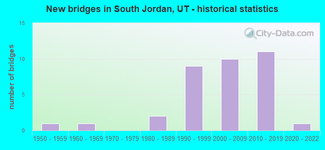
- New bridges - historical statistics
- 11950-1959
- 11960-1969
- 21980-1989
- 91990-1999
- 102000-2009
- 112010-2019
- 12020-2022
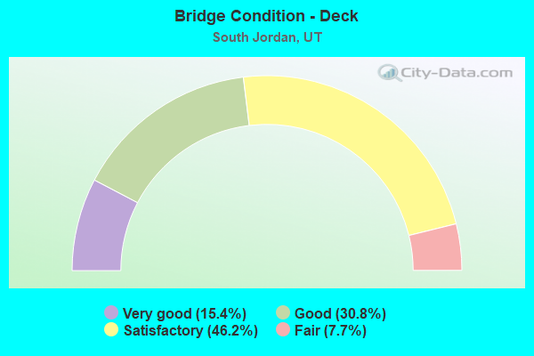
- Bridge Condition - Deck
- 15.4%Very good
- 30.8%Good
- 46.2%Satisfactory
- 7.7%Fair
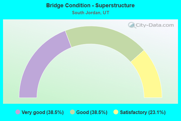
- Bridge Condition - Superstructure
- 38.5%Very good
- 38.5%Good
- 23.1%Satisfactory
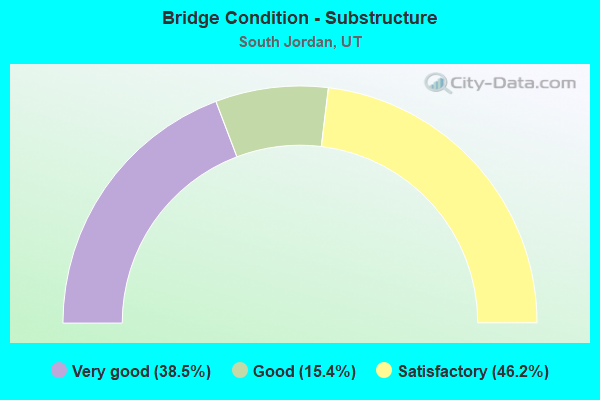
- Bridge Condition - Substructure
- 38.5%Very good
- 15.4%Good
- 46.2%Satisfactory
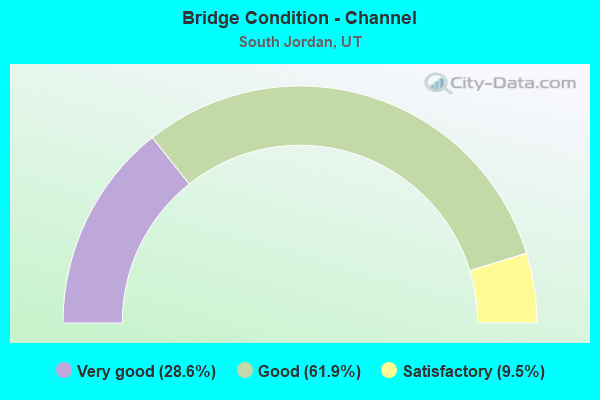
- Bridge Condition - Channel
- 28.6%Very good
- 61.9%Good
- 9.5%Satisfactory
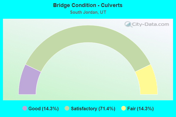
- Bridge Condition - Culverts
- 14.3%Good
- 71.4%Satisfactory
- 14.3%Fair
Find on map >> Show street view
Structure Number: 35016D, Location: 10500 S. 1300 W.,S.JORDAN (Lat: 40.560308, Lng: -111.929119), Route carried "on" structure: City street 2066, Year Built: 1950, Status: Open, Structure Length: 0.75m (2.46ft), Average Daily Traffic: 12,556 (year 2020), Average Future Daily Traffic: 15,695 (year 2040), Design Load: HL 93, Features Intersected: SOUTH JORDAN CANAL, Facility Carried by Structure: 1300 WEST STREET
Minimum Vertical Clearance: 30+ m (98+ ft), Kilometerpoint: 8.525, Lanes on structure: 3, Owner: City or Municipal Highway Agency, Approaching Roadway Width: 16.7m (54.8ft), Skew: 4 degrees, Material/Design: Concrete, Design/Construction: Frame, Number Of Spans In Main Unit: 1, Length of Maximum Span: 6.3m (20.7ft), Curb or Sidewalk Widths: Left: 3.5m (11.5ft), Right: 3.0m (9.8ft), Curb-To-Curb Width: 16.7m (54.8ft), Out-to-Out Width: 32.6m (107.0ft)
Condition: Deck: Satisfactory, Superstructure: Satisfactory, Substructure: Satisfactory, Channel: Good, Operating Rating: 32.4 metric tons, Method Used To Determine Operating Rating: Load and Resistance Factor Rating (LRFR) rating reported by rating factor(RF) method using HL-93 loadings, Inventory Rating: 19.4 metric tons, Method Used To Determine Inventory Rating: Load Factor (LF) rating reported by rating factor (RF) method using MS18 loading, Structural Evaluation: Meets minimum limits, Deck Geometry: Superior to present desirable criteria, Waterway Adequacy: Better than present minimum criteria, Approach Roadway Alignment: Equal to present desirable criteria, Designated Inspection Frequency: Every 24 months, Inspection Date: Febuary 2020, Deck Structure Type: Concrete Cast-file-Place, Wearing Surface/Protective System: Wearing Surface: Bituminous
Find on map >> Show street view
Structure Number: 35042E, Location: 9500 S. 3200 W.,S. JORDAN (Lat: 40.578436, Lng: -111.967297), Route carried "on" structure: City street 2094, Year Built: 1995, Status: Open, Structure Length: 1.25m (4.10ft), Average Daily Traffic: 11,337 (year 2020), Average Future Daily Traffic: 14,171 (year 2040), Design Load: HS 20+Mod, Features Intersected: UTAH LAKE DIST. CANAL, Facility Carried by Structure: 3200 WEST STREET
Minimum Vertical Clearance: 30+ m (98+ ft), Kilometerpoint: 4.641, Lanes on structure: 2, Owner: City or Municipal Highway Agency, Approaching Roadway Width: 12.2m (40.0ft), Skew: 6 degrees, Material/Design: Concrete, Design/Construction: Culvert, Number Of Spans In Main Unit: 1, Length of Maximum Span: 11.2m (36.7ft), Curb or Sidewalk Widths: Left: 1.5m (4.9ft), Right: 1.5m (4.9ft), Curb-To-Curb Width: 12.2m (40.0ft), Out-to-Out Width: 17.7m (58.1ft)
Condition: Channel: Good, Culverts: Satisfactory, Operating Rating: 38.6 metric tons, Method Used To Determine Operating Rating: Load Factor (LF) rating reported by rating factor (RF) method using MS18 loading, Inventory Rating: 24.6 metric tons, Method Used To Determine Inventory Rating: Load Factor (LF) rating reported by rating factor (RF) method using MS18 loading, Structural Evaluation: Equal to present minimum criteria, Deck Geometry: Somewhat better than minimum adequacy, Waterway Adequacy: Somewhat better than minimum adequacy, Approach Roadway Alignment: Equal to present desirable criteria, Designated Inspection Frequency: Every 24 months, Inspection Date: Febuary 2020
Find on map >> Show street view
Structure Number: 35112D, Location: 2220 W. 11170 S. (Lat: 40.548331, Lng: -111.948600), Route carried "on" structure: City street , Year Built: 2003, Status: Open, Structure Length: 0.66m (2.17ft), Average Daily Traffic: 378 (year 2020), Truck Traffic: 1%, Average Future Daily Traffic: 459 (year 2040), Design Load: HS 20+Mod, Features Intersected: UTAH AND SALT LAKE CAN, Facility Carried by Structure: OLD ROSEBUD LANE
Minimum Vertical Clearance: 30+ m (98+ ft), Kilometerpoint: 0.056, Lanes on structure: 2, Owner: City or Municipal Highway Agency, Approaching Roadway Width: 9.1m (29.9ft), Material/Design: Concrete, Design/Construction: Frame, Number Of Spans In Main Unit: 1, Length of Maximum Span: 6.1m (20.0ft), Curb or Sidewalk Widths: Left: 1.5m (4.9ft), Right: 1.5m (4.9ft), Curb-To-Curb Width: 9.1m (29.9ft), Out-to-Out Width: 14.7m (48.2ft)
Condition: Deck: Very good, Superstructure: Very good, Substructure: Very good, Channel: Good, Operating Rating: 32.4 metric tons, Method Used To Determine Operating Rating: Load and Resistance Factor Rating (LRFR) rating reported by rating factor(RF) method using HL-93 loadings, Inventory Rating: 19.4 metric tons, Method Used To Determine Inventory Rating: Load Factor (LF) rating reported by rating factor (RF) method using MS18 loading, Structural Evaluation: Somewhat better than minimum adequacy, Deck Geometry: Equal to present minimum criteria, Waterway Adequacy: Equal to present desirable criteria, Approach Roadway Alignment: Somewhat better than minimum adequacy, Designated Inspection Frequency: Every 24 months, Inspection Date: Febuary 2020, Deck Structure Type: Concrete Cast-file-Place, Wearing Surface/Protective System: Wearing Surface: Integral Concrete
Find on map >> Show street view
Structure Number: 35121V, Location: 10830 S. 2200 WEST ST. (Lat: 40.554394, Lng: -111.948189), Route carried "on" structure: City street 2085, Year Built: 1980, Status: Open, Structure Length: 1.16m (3.81ft), Average Daily Traffic: 1,000 (year 2020), Average Future Daily Traffic: 1,250 (year 2040), Design Load: HS 20+Mod, Features Intersected: UTAH AND SALT LAKE CANAL, Facility Carried by Structure: 2200 WEST STREET
Minimum Vertical Clearance: 30+ m (98+ ft), Kilometerpoint: 1.137, Lanes on structure: 2, Owner: City or Municipal Highway Agency, Approaching Roadway Width: 14.1m (46.3ft), Skew: 6 degrees, Material/Design: Steel, Design/Construction: Culvert, Number Of Spans In Main Unit: 1, Length of Maximum Span: 11.0m (36.1ft), Curb or Sidewalk Widths: Left: 1.2m (3.9ft), Right: 0.0m
Condition: Channel: Good, Culverts: Fair, Operating Rating: 32.4 metric tons, Method Used To Determine Operating Rating: Load and Resistance Factor Rating (LRFR) rating reported by rating factor(RF) method using HL-93 loadings, Inventory Rating: 24.9 metric tons, Method Used To Determine Inventory Rating: Load and Resistance Factor Rating (LRFR) rating reported by rating factor(RF) method using HL-93 loadings, Structural Evaluation: Somewhat better than minimum adequacy, Waterway Adequacy: Equal to present desirable criteria, Approach Roadway Alignment: Equal to present desirable criteria, Designated Inspection Frequency: Every 24 months, Inspection Date: Febuary 2020
Find on map >> Show street view
Structure Number: 35139V, Location: 9500 S. 2200 WEST STREET (Lat: 40.577825, Lng: -111.948219), Route carried "on" structure: City street 2085, Year Built: 1980, Status: Posted for load, Structure Length: 1.17m (3.84ft), Average Daily Traffic: 1,000 (year 2020), Average Future Daily Traffic: 1,250 (year 2040), Design Load: HS 20+Mod, Features Intersected: UTAH AND SALT LAKE CAN, Facility Carried by Structure: 2200 WEST STREET
Minimum Vertical Clearance: 30+ m (98+ ft), Kilometerpoint: 3.738, Lanes on structure: 2, Owner: City or Municipal Highway Agency, Approaching Roadway Width: 11.1m (36.4ft), Skew: 5 degrees, Material/Design: Steel, Design/Construction: Culvert, Number Of Spans In Main Unit: 1, Length of Maximum Span: 10.6m (34.8ft)
Condition: Channel: Good, Culverts: Satisfactory, Operating Rating: 23.3 metric tons, Method Used To Determine Operating Rating: Load and Resistance Factor Rating (LRFR) rating reported by rating factor(RF) method using HL-93 loadings, Inventory Rating: 17.5 metric tons, Method Used To Determine Inventory Rating: Load and Resistance Factor Rating (LRFR) rating reported by rating factor(RF) method using HL-93 loadings, Structural Evaluation: Meets minimum limits, Waterway Adequacy: Equal to present desirable criteria, Approach Roadway Alignment: Equal to present desirable criteria, Bridge Posting: Required (Relationship of Operating Rating to Maximum Legal Load: 20.0 - 29.9% below), Designated Inspection Frequency: Every 24 months, Inspection Date: Febuary 2020
Find on map >> Show street view
Structure Number: 35181F, Location: 900 WEST 9840 SOUTH (Lat: 40.572097, Lng: -111.916086), Route carried "on" structure: City street 2080, Year Built: 2003, Status: Open, Structure Length: 3.75m (12.30ft), Average Daily Traffic: 9,024 (year 2020), Average Future Daily Traffic: 11,280 (year 2040), Design Load: HS 20+Mod, Features Intersected: JORDAN RIVER, Facility Carried by Structure: SHIELDS LANE
Minimum Vertical Clearance: 30+ m (98+ ft), Kilometerpoint: 5.201, Lanes on structure: 2, Owner: City or Municipal Highway Agency, Approaching Roadway Width: 13.7m (44.9ft), Skew: 2 degrees, Material/Design: Prestressed concrete, Design/Construction: Stringer/Multi-beam, Number Of Spans In Main Unit: 1, Length of Maximum Span: 36.6m (120.1ft), Curb or Sidewalk Widths: Left: 2.6m (8.5ft), Right: 2.6m (8.5ft), Curb-To-Curb Width: 13.7m (44.9ft), Out-to-Out Width: 19.4m (63.6ft)
Condition: Deck: Fair, Superstructure: Good, Substructure: Good, Channel: Good, Operating Rating: 50.5 metric tons, Method Used To Determine Operating Rating: Load and Resistance Factor Rating (LRFR) rating reported by rating factor(RF) method using HL-93 loadings, Inventory Rating: 41.8 metric tons, Method Used To Determine Inventory Rating: Load Factor (LF) rating reported by rating factor (RF) method using MS18 loading, Structural Evaluation: Better than present minimum criteria, Deck Geometry: Superior to present desirable criteria, Waterway Adequacy: Equal to present desirable criteria, Approach Roadway Alignment: Equal to present desirable criteria, Designated Inspection Frequency: Every 24 months, Inspection Date: Febuary 2020, Deck Structure Type: Concrete Cast-file-Place, Wearing Surface/Protective System: Wearing Surface: Integral Concrete, Deck Protection: Epoxy Coated Reinforcing
Find on map >> Show street view
Structure Number: 35182V, Location: 9840 SOUTH 900 WEST (Lat: 40.572039, Lng: -111.916761), Route carried "on" structure: City street 2080, Year Built: 2003, Status: Open, Structure Length: 0.62m (2.03ft), Average Daily Traffic: 9,024 (year 2020), Average Future Daily Traffic: 11,280 (year 2040), Design Load: HS 20, Features Intersected: JORDAN PATHWAY, Facility Carried by Structure: SHIELDS LANE
Minimum Vertical Clearance: 30+ m (98+ ft), Kilometerpoint: 5.143, Lanes on structure: 2, Owner: City or Municipal Highway Agency, Approaching Roadway Width: 13.7m (44.9ft), Skew: 3 degrees, Material/Design: Steel, Design/Construction: Culvert, Number Of Spans In Main Unit: 1, Length of Maximum Span: 6.2m (20.3ft), Curb or Sidewalk Widths: Left: 1.5m (4.9ft), Right: 1.5m (4.9ft)
Condition: Culverts: Satisfactory, Operating Rating: 75.8 metric tons, Method Used To Determine Operating Rating: Load and Resistance Factor Rating (LRFR) rating reported by rating factor(RF) method using HL-93 loadings, Inventory Rating: 33.7 metric tons, Method Used To Determine Inventory Rating: Load and Resistance Factor Rating (LRFR) rating reported by rating factor(RF) method using HL-93 loadings, Structural Evaluation: Equal to present minimum criteria, Approach Roadway Alignment: Equal to present desirable criteria, Designated Inspection Frequency: Every 24 months, Inspection Date: Febuary 2020
Find on map >> Show street view
Structure Number: 35196E, Location: 111380 S.3200 W.,S.JORDAN (Lat: 40.544133, Lng: -111.966422), Route carried "on" structure: City street 175, Year Built: 2006, Status: Open, Structure Length: 0.81m (2.66ft), Average Daily Traffic: 29,173 (year 2020), Truck Traffic: 29%, Average Future Daily Traffic: 36,466 (year 2040), Design Load: HS 20+Mod, Features Intersected: UT.LAKE DIST.CANAL, Facility Carried by Structure: 3200 WEST STREET
Minimum Vertical Clearance: 30+ m (98+ ft), Kilometerpoint: 1.514, Lanes on structure: 2, Owner: City or Municipal Highway Agency, Approaching Roadway Width: 16.0m (52.5ft), Skew: 5 degrees, Material/Design: Concrete, Design/Construction: Culvert, Number Of Spans In Main Unit: 1, Length of Maximum Span: 6.1m (20.0ft), Curb or Sidewalk Widths: Left: 3.2m (10.5ft), Right: 3.2m (10.5ft), Curb-To-Curb Width: 16.0m (52.5ft), Out-to-Out Width: 21.0m (68.9ft)
Condition: Channel: Good, Culverts: Satisfactory, Operating Rating: 32.4 metric tons, Method Used To Determine Operating Rating: Load and Resistance Factor Rating (LRFR) rating reported by rating factor(RF) method using HL-93 loadings, Inventory Rating: 19.4 metric tons, Method Used To Determine Inventory Rating: Load Factor (LF) rating reported by rating factor (RF) method using MS18 loading, Structural Evaluation: Meets minimum limits, Deck Geometry: Superior to present desirable criteria, Approach Roadway Alignment: Equal to present desirable criteria, Designated Inspection Frequency: Every 24 months, Inspection Date: Febuary 2020, Deck Structure Type: Concrete Cast-file-Place, Wearing Surface/Protective System: Wearing Surface: Monolithic Concrete, Deck Protection: Epoxy Coated Reinforcing
Find on map >> Show street view
Structure Number: 35197D, Location: 1230 W. 11460 S. (Lat: 40.543100, Lng: -111.927328), Route carried "on" structure: Alternate City street , Year Built: 2006, Status: Open, Structure Length: 0.72m (2.36ft), Average Daily Traffic: 378 (year 2020), Truck Traffic: 1%, Average Future Daily Traffic: 459 (year 2040), Design Load: HS 20+Mod, Features Intersected: MIDAS CREEK, Facility Carried by Structure: CHAPEL RIDGE DRIVE
Minimum Vertical Clearance: 30+ m (98+ ft), Kilometerpoint: 0.157, Lanes on structure: 2, Owner: City or Municipal Highway Agency, Approaching Roadway Width: 9.7m (31.8ft), Material/Design: Concrete, Design/Construction: Frame, Number Of Spans In Main Unit: 1, Length of Maximum Span: 6.6m (21.7ft), Curb or Sidewalk Widths: Left: 2.1m (6.9ft), Right: 2.1m (6.9ft), Curb-To-Curb Width: 9.7m (31.8ft), Out-to-Out Width: 13.9m (45.6ft)
Condition: Deck: Very good, Superstructure: Very good, Substructure: Good, Channel: Very good, Operating Rating: 32.4 metric tons, Method Used To Determine Operating Rating: Load and Resistance Factor Rating (LRFR) rating reported by rating factor(RF) method using HL-93 loadings, Inventory Rating: 19.4 metric tons, Method Used To Determine Inventory Rating: Load Factor (LF) rating reported by rating factor (RF) method using MS18 loading, Structural Evaluation: Somewhat better than minimum adequacy, Deck Geometry: Equal to present minimum criteria, Waterway Adequacy: Better than present minimum criteria, Approach Roadway Alignment: Equal to present minimum criteria, Designated Inspection Frequency: Every 24 months, Inspection Date: Febuary 2020, Deck Structure Type: Concrete Cast-file-Place, Wearing Surface/Protective System: Wearing Surface: Bituminous, Deck Protection: Epoxy Coated Reinforcing
Find on map >> Show street view
Structure Number: 35198E, Location: 11200 SOUTH 920 WEST (Lat: 40.548467, Lng: -111.917275), Route carried "on" structure: City street 2179, Year Built: 2006, Status: Open, Structure Length: 0.87m (2.85ft), Average Daily Traffic: 500 (year 2020), Average Future Daily Traffic: 625 (year 2040), Design Load: HS 20+Mod, Features Intersected: MIDAS CREEK, Facility Carried by Structure: RIVER FRONT PKWAY.
Minimum Vertical Clearance: 30+ m (98+ ft), Kilometerpoint: 0.472, Lanes on structure: 2, Owner: City or Municipal Highway Agency, Approaching Roadway Width: 13.6m (44.6ft), Material/Design: Concrete, Design/Construction: Culvert, Number Of Spans In Main Unit: 2, Length of Maximum Span: 4.0m (13.1ft), Curb or Sidewalk Widths: Left: 2.9m (9.5ft), Right: 3.1m (10.2ft), Curb-To-Curb Width: 13.6m (44.6ft), Out-to-Out Width: 20.1m (65.9ft)
Condition: Channel: Satisfactory, Culverts: Satisfactory, Operating Rating: 32.4 metric tons, Method Used To Determine Operating Rating: Load and Resistance Factor Rating (LRFR) rating reported by rating factor(RF) method using HL-93 loadings, Inventory Rating: 17.8 metric tons, Method Used To Determine Inventory Rating: Load Factor (LF) rating reported by rating factor (RF) method using MS18 loading, Structural Evaluation: Somewhat better than minimum adequacy, Deck Geometry: Superior to present desirable criteria, Waterway Adequacy: Equal to present minimum criteria, Approach Roadway Alignment: Equal to present desirable criteria, Designated Inspection Frequency: Every 24 months, Inspection Date: Febuary 2020
Find on map >> Show street view
Structure Number: 35199E, Location: 1985 WEST 10530 SOUTH (Lat: 40.559664, Lng: -111.944217), Route carried "on" structure: City street , Year Built: 2000, Status: Open, Structure Length: 0.68m (2.23ft), Average Daily Traffic: 1,000 (year 2020), Truck Traffic: 1%, Average Future Daily Traffic: 1,250 (year 2040), Design Load: HS 20+Mod, Features Intersected: UTAH-SALT LAKE CANAL, Facility Carried by Structure: HAVEN HEIGHTS ROAD
Minimum Vertical Clearance: 30+ m (98+ ft), Kilometerpoint: 0.042, Lanes on structure: 2, Owner: City or Municipal Highway Agency, Approaching Roadway Width: 10.3m (33.8ft), Material/Design: Concrete, Design/Construction: Culvert, Number Of Spans In Main Unit: 1, Length of Maximum Span: 6.1m (20.0ft), Curb or Sidewalk Widths: Left: 2.0m (6.6ft), Right: 2.0m (6.6ft), Curb-To-Curb Width: 10.3m (33.8ft), Out-to-Out Width: 13.0m (42.7ft)
Condition: Channel: Good, Culverts: Satisfactory, Operating Rating: 32.4 metric tons, Method Used To Determine Operating Rating: Load and Resistance Factor Rating (LRFR) rating reported by rating factor(RF) method using HL-93 loadings, Inventory Rating: 19.4 metric tons, Method Used To Determine Inventory Rating: Load Factor (LF) rating reported by rating factor (RF) method using MS18 loading, Structural Evaluation: Somewhat better than minimum adequacy, Deck Geometry: Equal to present minimum criteria, Waterway Adequacy: Equal to present desirable criteria, Approach Roadway Alignment: Equal to present desirable criteria, Designated Inspection Frequency: Every 24 months, Inspection Date: Febuary 2020
Find on map >> Show street view
Structure Number: 35200E, Location: 1900 W. 9800 S. (Lat: 40.573208, Lng: -111.944753), Route carried "on" structure: Alternate City street 2080, Year Built: 2006, Status: Open, Structure Length: 0.82m (2.69ft), Average Daily Traffic: 4,350 (year 2020), Average Future Daily Traffic: 5,438 (year 2040), Design Load: HS 20+Mod, Features Intersected: UTAH AND SALT LAKE CAN, Facility Carried by Structure: SHIELDS LANE
Minimum Vertical Clearance: 30+ m (98+ ft), Kilometerpoint: 2.743, Lanes on structure: 2, Owner: City or Municipal Highway Agency, Approaching Roadway Width: 13.7m (44.9ft), Skew: 3 degrees, Material/Design: Concrete, Design/Construction: Culvert, Number Of Spans In Main Unit: 1, Length of Maximum Span: 7.4m (24.3ft), Curb or Sidewalk Widths: Left: 2.0m (6.6ft), Right: 2.0m (6.6ft), Curb-To-Curb Width: 13.7m (44.9ft), Out-to-Out Width: 26.7m (87.6ft)
Condition: Channel: Good, Culverts: Good, Operating Rating: 43.7 metric tons, Method Used To Determine Operating Rating: Load and Resistance Factor Rating (LRFR) rating reported by rating factor(RF) method using HL-93 loadings, Inventory Rating: 28.5 metric tons, Method Used To Determine Inventory Rating: Load Factor (LF) rating reported by rating factor (RF) method using MS18 loading, Structural Evaluation: Better than present minimum criteria, Deck Geometry: Superior to present desirable criteria, Waterway Adequacy: Better than present minimum criteria, Approach Roadway Alignment: Equal to present desirable criteria, Designated Inspection Frequency: Every 24 months, Inspection Date: Febuary 2020
Find on map >> Show street view
Structure Number: 35208E, Location: 11725 S. 3200 W.,S.JORDAN (Lat: 40.538214, Lng: -111.966817), Route carried "on" structure: ServiceCity street 2094, Year Built: 2010, Status: Open, Structure Length: 0.76m (2.49ft), Average Daily Traffic: 2,001 (year 2020), Average Future Daily Traffic: 2,501 (year 2040), Design Load: HS 20+Mod, Features Intersected: MIDAS CREEK CHANNEL, Facility Carried by Structure: 3200 WEST STREET
Minimum Vertical Clearance: 30+ m (98+ ft), Kilometerpoint: 0.153, Lanes on structure: 2, Owner: City or Municipal Highway Agency, Approaching Roadway Width: 8.9m (29.2ft), Skew: 1 degrees, Material/Design: Concrete, Design/Construction: Culvert, Number Of Spans In Main Unit: 1, Length of Maximum Span: 7.6m (24.9ft), Curb or Sidewalk Widths: Left: 0.2m (0.7ft), Right: 0.2m (0.7ft), Curb-To-Curb Width: 8.9m (29.2ft), Out-to-Out Width: 12.4m (40.7ft)
Condition: Channel: Very good, Culverts: Fair, Operating Rating: 32.4 metric tons, Method Used To Determine Operating Rating: Load and Resistance Factor Rating (LRFR) rating reported by rating factor(RF) method using HL-93 loadings, Inventory Rating: 19.8 metric tons, Method Used To Determine Inventory Rating: Load Factor (LF) rating reported by rating factor (RF) method using MS18 loading, Structural Evaluation: Somewhat better than minimum adequacy, Deck Geometry: Meets minimum limits, Waterway Adequacy: Equal to present desirable criteria, Approach Roadway Alignment: Equal to present desirable criteria, Designated Inspection Frequency: Every 24 months, Inspection Date: January 2022, Deck Structure Type: Concrete Cast-file-Place, Wearing Surface/Protective System: Deck Protection: Epoxy Coated Reinforcing
Find on map >> Show street view
Structure Number: C 98, Location: 11400 So. & Jordan Ri (Lat: 40.544253, Lng: -111.917511), Route carried "on" structure: State highway 175, Year Built: 2010, Status: Open, Structure Length: 12.48m (40.94ft), Average Daily Traffic: 19,836 (year 2020), Truck Traffic: 29%, Average Future Daily Traffic: 24,795 (year 2040), Design Load: HL 93, Features Intersected: JORDAN RIVER
Minimum Vertical Clearance: 30+ m (98+ ft), Kilometerpoint: 5.656, Lanes on structure: 4, Owner: State Highway Agency, Approaching Roadway Width: 26.8m (87.9ft), Skew: 2 degrees, Material/Design: Steel continuous, Design/Construction: Stringer/Multi-beam, Number Of Spans In Main Unit: 3, Length of Maximum Span: 56.4m (185.0ft), Curb or Sidewalk Widths: Left: 2.0m (6.6ft), Right: 2.0m (6.6ft), Curb-To-Curb Width: 26.8m (87.9ft), Out-to-Out Width: 31.6m (103.7ft)
Condition: Deck: Satisfactory, Superstructure: Good, Substructure: Satisfactory, Channel: Very good, Operating Rating: 48.3 metric tons, Method Used To Determine Operating Rating: Load and Resistance Factor Rating (LRFR) rating reported by rating factor(RF) method using HL-93 loadings, Inventory Rating: 30.8 metric tons, Method Used To Determine Inventory Rating: Load and Resistance Factor Rating (LRFR) rating reported by rating factor(RF) method using HL-93 loadings, Structural Evaluation: Equal to present minimum criteria, Deck Geometry: Superior to present desirable criteria, Waterway Adequacy: Better than present minimum criteria, Approach Roadway Alignment: Equal to present desirable criteria, Designated Inspection Frequency: Every 24 months, Inspection Date: November 2020, Deck Structure Type: Concrete Cast-file-Place, Wearing Surface/Protective System: Wearing Surface: Epoxy Overlay, Membrane: Epoxy, Deck Protection: Epoxy Coated Reinforcing
Find on map >> Show street view
Structure Number: E1445, Location: At 10100 SO.& I-15,SANDY (Lat: 40.565767, Lng: -111.899339), Route carried "on" structure: Interstate 15, Year Built: 1964, Year Reconstructed: 1998, Status: Open, Structure Length: 0.61m (2.00ft), Average Daily Traffic: 166,420 (year 2020), Truck Traffic: 21%, Average Future Daily Traffic: 208,025 (year 2040), Design Load: HS 20+Mod, Features Intersected: DRY CREEK
Minimum Vertical Clearance: 30+ m (98+ ft), Kilometerpoint: 473.839, Lanes on structure: 10, Base Highway Network: Yes, Owner: State Highway Agency, Approaching Roadway Width: 47.5m (155.8ft), Skew: 33 degrees, Material/Design: Concrete, Design/Construction: Culvert, Number Of Spans In Main Unit: 2, Length of Maximum Span: 5.5m (18.0ft), Curb-To-Curb Width: 47.5m (155.8ft), Out-to-Out Width: 47.5m (155.8ft)
Condition: Channel: Satisfactory, Culverts: Satisfactory, Operating Rating: 44.7 metric tons, Method Used To Determine Operating Rating: Load and Resistance Factor Rating (LRFR) rating reported by rating factor(RF) method using HL-93 loadings, Inventory Rating: 29.8 metric tons, Method Used To Determine Inventory Rating: Load and Resistance Factor Rating (LRFR) rating reported by rating factor(RF) method using HL-93 loadings, Structural Evaluation: Equal to present minimum criteria, Deck Geometry: Superior to present desirable criteria, Waterway Adequacy: Equal to present minimum criteria, Approach Roadway Alignment: Equal to present desirable criteria, Designated Inspection Frequency: Every 24 months, Inspection Date: November 2020
Find on map >> Show street view
Structure Number: E2568, Location: Just W. of Redwood Road (Lat: 40.562303, Lng: -111.940028), Route carried "on" structure: State highway 151, Year Built: 2010, Status: Open, Structure Length: 0.73m (2.40ft), Average Daily Traffic: 13,422 (year 2020), Truck Traffic: 21%, Average Future Daily Traffic: 16,778 (year 2040), Design Load: HL 93, Features Intersected: UTAH and SALT LAKE CANAL
Minimum Vertical Clearance: 30+ m (98+ ft), Kilometerpoint: 3.138, Lanes on structure: 6, Owner: State Highway Agency, Approaching Roadway Width: 27.4m (89.9ft), Skew: 30 degrees, Material/Design: Concrete, Design/Construction: Culvert, Number Of Spans In Main Unit: 1, Length of Maximum Span: 6.7m (22.0ft), Curb or Sidewalk Widths: Left: 3.0m (9.8ft), Right: 3.0m (9.8ft)
Condition: Channel: Good, Culverts: Satisfactory, Operating Rating: 46.0 metric tons, Method Used To Determine Operating Rating: Load Factor (LF) rating reported by rating factor (RF) method using MS18 loading, Inventory Rating: 32.4 metric tons, Method Used To Determine Inventory Rating: Load Factor (LF) rating reported by rating factor (RF) method using MS18 loading, Structural Evaluation: Equal to present minimum criteria, Waterway Adequacy: Equal to present desirable criteria, Approach Roadway Alignment: Equal to present desirable criteria, Designated Inspection Frequency: Every 24 months, Inspection Date: December 2020
Find on map >> Show street view
Structure Number: E2613, Location: 2250 W.11400 SO.SO.JORDAN (Lat: 40.544136, Lng: -111.948903), Route carried "on" structure: State highway 175, Year Built: 2009, Status: Open, Structure Length: 0.80m (2.62ft), Average Daily Traffic: 29,173 (year 2020), Truck Traffic: 29%, Average Future Daily Traffic: 36,466 (year 2040), Design Load: HL 93, Features Intersected: UTAH & SALT LAKE CANAL
Minimum Vertical Clearance: 30+ m (98+ ft), Kilometerpoint: 2.997, Lanes on structure: 5, Base Highway Network: Yes, Owner: State Highway Agency, Approaching Roadway Width: 22.6m (74.1ft), Skew: 21 degrees, Material/Design: Concrete, Design/Construction: Culvert, Number Of Spans In Main Unit: 1, Length of Maximum Span: 7.4m (24.3ft), Curb or Sidewalk Widths: Left: 1.5m (4.9ft), Right: 1.5m (4.9ft)
Condition: Channel: Good, Culverts: Satisfactory, Operating Rating: 32.4 metric tons, Method Used To Determine Operating Rating: Load and Resistance Factor Rating (LRFR) rating reported by rating factor(RF) method using HL-93 loadings, Inventory Rating: 32.1 metric tons, Method Used To Determine Inventory Rating: Load and Resistance Factor Rating (LRFR) rating reported by rating factor(RF) method using HL-93 loadings, Structural Evaluation: Equal to present minimum criteria, Waterway Adequacy: Better than present minimum criteria, Approach Roadway Alignment: Equal to present desirable criteria, Designated Inspection Frequency: Every 24 months, Inspection Date: December 2020, Deck Structure Type: Concrete Cast-file-Place
Find on map >> Show street view
Structure Number: F 596, Location: 3800 West 11800 South (Lat: 40.536658, Lng: -111.984192), Route carried "on" structure: State highway 154, Year Built: 1997, Status: Open, Structure Length: 4.28m (14.04ft), Average Daily Traffic: 39,249 (year 2020), Truck Traffic: 22%, Average Future Daily Traffic: 49,061 (year 2040), Design Load: HS 20+Mod, Features Intersected: 11800 S. STREET
Minimum Vertical Clearance: 30+ m (98+ ft), Kilometerpoint: 12.492, Lanes on structure: 6, Lanes under structure: 4, Base Highway Network: Yes, Owner: State Highway Agency, Approaching Roadway Width: 30.0m (98.4ft), Skew: 30 degrees, Material/Design: Prestressed concrete, Design/Construction: Stringer/Multi-beam, Number Of Spans In Main Unit: 1, Length of Maximum Span: 42.0m (137.8ft), Curb-To-Curb Width: 30.0m (98.4ft), Out-to-Out Width: 31.9m (104.7ft)
Condition: Deck: Satisfactory, Superstructure: Satisfactory, Substructure: Satisfactory, Operating Rating: 41.8 metric tons, Method Used To Determine Operating Rating: Load and Resistance Factor Rating (LRFR) rating reported by rating factor(RF) method using HL-93 loadings, Inventory Rating: 37.6 metric tons, Method Used To Determine Inventory Rating: Load and Resistance Factor Rating (LRFR) rating reported by rating factor(RF) method using HL-93 loadings, Structural Evaluation: Equal to present minimum criteria, Deck Geometry: Superior to present desirable criteria, Underclear: Better than present minimum criteria, Approach Roadway Alignment: Equal to present desirable criteria, Designated Inspection Frequency: Every 24 months, Inspection Date: December 2020, Deck Structure Type: Concrete Cast-file-Place, Wearing Surface/Protective System: Wearing Surface: Epoxy Overlay, Deck Protection: Epoxy Coated Reinforcing
Find on map >> Show street view
Structure Number: F 663, Location: 106th SOUTH INTERCHANGE (Lat: 40.558958, Lng: -111.898803), Route carried "on" structure: State highway 151, Year Built: 1999, Status: Open, Structure Length: 5.69m (18.67ft), Average Daily Traffic: 41,373 (year 2020), Truck Traffic: 25%, Average Future Daily Traffic: 51,716 (year 2040), Design Load: HS 25 or greater, Features Intersected: I-15 (SR-15) NBL & SBL
Minimum Vertical Clearance: 5.44m (17.85ft), Kilometerpoint: 6.677, Lanes on structure: 8, Lanes under structure: 10, Owner: State Highway Agency, Approaching Roadway Width: 33.2m (108.9ft), Skew: 1 degrees, Material/Design: Prestressed concrete continuous, Design/Construction: Stringer/Multi-beam, Number Of Spans In Main Unit: 2, Length of Maximum Span: 28.0m (91.9ft), Curb or Sidewalk Widths: Left: 1.2m (3.9ft), Right: 1.2m (3.9ft), Curb-To-Curb Width: 34.7m (113.8ft), Out-to-Out Width: 53.7m (176.2ft)
Condition: Deck: Satisfactory, Superstructure: Satisfactory, Substructure: Satisfactory, Operating Rating: 36.9 metric tons, Method Used To Determine Operating Rating: Load and Resistance Factor Rating (LRFR) rating reported by rating factor(RF) method using HL-93 loadings, Inventory Rating: 35.3 metric tons, Method Used To Determine Inventory Rating: Load Factor (LF) rating reported by rating factor (RF) method using MS18 loading, Structural Evaluation: Equal to present minimum criteria, Deck Geometry: Better than present minimum criteria, Underclear: Somewhat better than minimum adequacy, Approach Roadway Alignment: Equal to present desirable criteria, Designated Inspection Frequency: Every 24 months, Inspection Date: November 2020, Deck Structure Type: Concrete Cast-file-Place, Wearing Surface/Protective System: Wearing Surface: Latex Concrete, Deck Protection: Epoxy Coated Reinforcing
Find on map >> Show street view
Structure Number: F 683, Location: 600 W.10600 S.So.,Jordan (Lat: 40.558900, Lng: -111.908300), Route carried "on" structure: State highway 151, Year Built: 2002, Status: Open, Structure Length: 3.36m (11.02ft), Average Daily Traffic: 41,373 (year 2020), Truck Traffic: 25%, Average Future Daily Traffic: 51,716 (year 2040), Design Load: HS 20, Features Intersected: JORDAN RIVER
Minimum Vertical Clearance: 30+ m (98+ ft), Kilometerpoint: 5.873, Lanes on structure: 4, Owner: State Highway Agency, Approaching Roadway Width: 26.5m (86.9ft), Skew: 20 degrees, Material/Design: Prestressed concrete, Design/Construction: Stringer/Multi-beam, Number Of Spans In Main Unit: 1, Length of Maximum Span: 32.8m (107.6ft), Curb or Sidewalk Widths: Left: 1.9m (6.2ft), Right: 1.9m (6.2ft), Curb-To-Curb Width: 27.6m (90.6ft), Out-to-Out Width: 33.3m (109.3ft)
Condition: Deck: Satisfactory, Superstructure: Good, Substructure: Satisfactory, Channel: Good, Operating Rating: 42.1 metric tons, Method Used To Determine Operating Rating: Load and Resistance Factor Rating (LRFR) rating reported by rating factor(RF) method using HL-93 loadings, Inventory Rating: 40.5 metric tons, Method Used To Determine Inventory Rating: Load and Resistance Factor Rating (LRFR) rating reported by rating factor(RF) method using HL-93 loadings, Structural Evaluation: Equal to present minimum criteria, Deck Geometry: Superior to present desirable criteria, Waterway Adequacy: Equal to present desirable criteria, Approach Roadway Alignment: Equal to present desirable criteria, Designated Inspection Frequency: Every 24 months, Inspection Date: November 2020, Deck Structure Type: Concrete Cast-file-Place, Wearing Surface/Protective System: Wearing Surface: Epoxy Overlay, Deck Protection: Epoxy Coated Reinforcing
Find on map >> Show street view
Structure Number: V2101, Location: Just east of 1300 W. St. (Lat: 40.544175, Lng: -111.927350), Route carried "on" structure: State highway 175, Year Built: 2010, Status: Open, Structure Length: 0.78m (2.56ft), Average Daily Traffic: 19,836 (year 2020), Truck Traffic: 29%, Average Future Daily Traffic: 24,795 (year 2040), Design Load: HS 25 or greater, Features Intersected: MIDAS CREEK
Minimum Vertical Clearance: 30+ m (98+ ft), Kilometerpoint: 4.823, Lanes on structure: 4, Base Highway Network: Yes, Owner: State Highway Agency, Approaching Roadway Width: 18.3m (60.0ft), Skew: 30 degrees, Material/Design: Steel, Design/Construction: Culvert, Number Of Spans In Main Unit: 1, Number Of Approach Spans: 1, Length of Maximum Span: 7.3m (24.0ft), Curb or Sidewalk Widths: Left: 1.5m (4.9ft), Right: 1.5m (4.9ft), Curb-To-Curb Width: 18.3m (60.0ft), Out-to-Out Width: 43.6m (143.0ft)
Condition: Channel: Very good, Culverts: Satisfactory, Operating Rating: 63.2 metric tons, Method Used To Determine Operating Rating: Load and Resistance Factor Rating (LRFR) rating reported by rating factor(RF) method using HL-93 loadings, Inventory Rating: 32.4 metric tons, Method Used To Determine Inventory Rating: Load and Resistance Factor Rating (LRFR) rating reported by rating factor(RF) method using HL-93 loadings, Structural Evaluation: Equal to present minimum criteria, Deck Geometry: Somewhat better than minimum adequacy, Waterway Adequacy: Equal to present desirable criteria, Approach Roadway Alignment: Equal to present desirable criteria, Designated Inspection Frequency: Every 24 months, Inspection Date: November 2020
Find on map >> Show street view
Structure Number: 1F 646N, Location: 400 W.10000 So.in Sandy (Lat: 40.569444, Lng: -111.899794), Route carried "on" structure: Interstate 15, Year Built: 1999, Status: Open, Structure Length: 4.14m (13.58ft), Average Daily Traffic: 166,420 (year 2020), Truck Traffic: 21%, Average Future Daily Traffic: 208,025 (year 2040), Design Load: HS 25 or greater, Features Intersected: 10000 SOUTH STREET
Minimum Vertical Clearance: 30+ m (98+ ft), Kilometerpoint: 474.249, Lanes on structure: 5, Lanes under structure: 5, Base Highway Network: Yes, Owner: State Highway Agency, Approaching Roadway Width: 24.9m (81.7ft), Skew: 30 degrees, Material/Design: Prestressed concrete, Design/Construction: Stringer/Multi-beam, Number Of Spans In Main Unit: 1, Length of Maximum Span: 40.5m (132.9ft), Curb-To-Curb Width: 25.1m (82.3ft), Out-to-Out Width: 29.8m (97.8ft)
Condition: Deck: Satisfactory, Superstructure: Good, Substructure: Satisfactory, Operating Rating: 35.0 metric tons, Method Used To Determine Operating Rating: Load and Resistance Factor Rating (LRFR) rating reported by rating factor(RF) method using HL-93 loadings, Inventory Rating: 31.8 metric tons, Method Used To Determine Inventory Rating: Load and Resistance Factor Rating (LRFR) rating reported by rating factor(RF) method using HL-93 loadings, Structural Evaluation: Equal to present minimum criteria, Deck Geometry: Better than present minimum criteria, Underclear: Somewhat better than minimum adequacy, Approach Roadway Alignment: Equal to present desirable criteria, Designated Inspection Frequency: Every 24 months, Inspection Date: November 2020, Deck Structure Type: Concrete Cast-file-Place, Wearing Surface/Protective System: Wearing Surface: Epoxy Overlay, Deck Protection: Epoxy Coated Reinforcing
Find on map >> Show street view
Structure Number: 1F 8, Location: At 9280 So. Mt. View Cor. (Lat: 40.582672, Lng: -112.030069), Route carried "on" structure: State highway 85, Year Built: 2012, Status: Open, Structure Length: 3.94m (12.93ft), Average Daily Traffic: 11,111 (year 2020), Truck Traffic: 18%, Average Future Daily Traffic: 13,889 (year 2040), Design Load: HL 93, Features Intersected: 9280 South (Danon Way)
Minimum Vertical Clearance: 30+ m (98+ ft), Kilometerpoint: 21.127, Lanes on structure: 2, Lanes under structure: 2, Owner: State Highway Agency, Approaching Roadway Width: 14.6m (47.9ft), Skew: 13 degrees, Material/Design: Prestressed concrete, Design/Construction: Stringer/Multi-beam, Number Of Spans In Main Unit: 1, Length of Maximum Span: 38.0m (124.7ft), Curb-To-Curb Width: 14.6m (47.9ft), Out-to-Out Width: 15.5m (50.9ft)
Condition: Deck: Good, Superstructure: Very good, Substructure: Very good, Operating Rating: 44.4 metric tons, Method Used To Determine Operating Rating: Load and Resistance Factor Rating (LRFR) rating reported by rating factor(RF) method using HL-93 loadings, Inventory Rating: 33.7 metric tons, Method Used To Determine Inventory Rating: Load and Resistance Factor Rating (LRFR) rating reported by rating factor(RF) method using HL-93 loadings, Structural Evaluation: Equal to present desirable criteria, Deck Geometry: Superior to present desirable criteria, Underclear: Somewhat better than minimum adequacy, Approach Roadway Alignment: Equal to present desirable criteria, Designated Inspection Frequency: Every 24 months, Inspection Date: December 2020, Deck Structure Type: Concrete Cast-file-Place, Wearing Surface/Protective System: Wearing Surface: Epoxy Overlay, Deck Protection: Epoxy Coated Reinforcing
Find on map >> Show street view
Structure Number: 1F 804, Location: SR-85 OVER BINGHAM CR (Lat: 40.562050, Lng: -112.031314), Route carried "on" structure: State highway 85, Year Built: 2012, Status: Open, Structure Length: 3.19m (10.47ft), Average Daily Traffic: 28,839 (year 2020), Truck Traffic: 19%, Average Future Daily Traffic: 36,049 (year 2040), Design Load: HL 93, Features Intersected: BINGHAM CREEK
Minimum Vertical Clearance: 30+ m (98+ ft), Kilometerpoint: 18.742, Lanes on structure: 2, Owner: State Highway Agency, Approaching Roadway Width: 12.2m (40.0ft), Skew: 5 degrees, Material/Design: Prestressed concrete, Design/Construction: Stringer/Multi-beam, Number Of Spans In Main Unit: 1, Length of Maximum Span: 30.5m (100.1ft), Curb-To-Curb Width: 12.2m (40.0ft), Out-to-Out Width: 13.1m (43.0ft)
Condition: Deck: Good, Superstructure: Good, Substructure: Very good, Channel: Very good, Operating Rating: 61.6 metric tons, Method Used To Determine Operating Rating: Load and Resistance Factor Rating (LRFR) rating reported by rating factor(RF) method using HL-93 loadings, Inventory Rating: 36.6 metric tons, Method Used To Determine Inventory Rating: Load and Resistance Factor Rating (LRFR) rating reported by rating factor(RF) method using HL-93 loadings, Structural Evaluation: Better than present minimum criteria, Deck Geometry: Better than present minimum criteria, Approach Roadway Alignment: Equal to present desirable criteria, Designated Inspection Frequency: Every 24 months, Inspection Date: December 2020, Deck Structure Type: Concrete Cast-file-Place, Wearing Surface/Protective System: Wearing Surface: Epoxy Overlay, Deck Protection: Epoxy Coated Reinforcing
Find on map >> Show street view
Structure Number: 3F 8, Location: At 9280 South (Danon Way) (Lat: 40.583094, Lng: -112.030353), Route carried "on" structure: State highway 85, Year Built: 2012, Status: Open, Structure Length: 3.94m (12.93ft), Average Daily Traffic: 28,839 (year 2020), Truck Traffic: 19%, Average Future Daily Traffic: 36,049 (year 2040), Design Load: HL 93, Features Intersected: 9280 So (Danon Way)
Minimum Vertical Clearance: 30+ m (98+ ft), Kilometerpoint: 16.378, Lanes on structure: 2, Lanes under structure: 2, Owner: State Highway Agency, Approaching Roadway Width: 14.6m (47.9ft), Skew: 13 degrees, Material/Design: Prestressed concrete, Design/Construction: Stringer/Multi-beam, Number Of Spans In Main Unit: 1, Length of Maximum Span: 38.0m (124.7ft), Curb-To-Curb Width: 14.6m (47.9ft), Out-to-Out Width: 15.5m (50.9ft)
Condition: Deck: Good, Superstructure: Very good, Substructure: Very good, Operating Rating: 44.4 metric tons, Method Used To Determine Operating Rating: Load and Resistance Factor Rating (LRFR) rating reported by rating factor(RF) method using HL-93 loadings, Inventory Rating: 33.7 metric tons, Method Used To Determine Inventory Rating: Load and Resistance Factor Rating (LRFR) rating reported by rating factor(RF) method using HL-93 loadings, Structural Evaluation: Equal to present desirable criteria, Deck Geometry: Superior to present desirable criteria, Underclear: Somewhat better than minimum adequacy, Approach Roadway Alignment: Equal to present desirable criteria, Designated Inspection Frequency: Every 24 months, Inspection Date: December 2020, Deck Structure Type: Concrete Cast-file-Place, Wearing Surface/Protective System: Wearing Surface: Epoxy Overlay, Deck Protection: Epoxy Coated Reinforcing
Find on map >> Show street view
Structure Number: 3F 803, Location: Approx. 10200 South (Lat: 40.560986, Lng: -112.032347), Route carried "on" structure: State highway 85, Year Built: 2012, Status: Open, Structure Length: 3.26m (10.70ft), Average Daily Traffic: 25,188 (year 2020), Truck Traffic: 20%, Average Future Daily Traffic: 31,485 (year 2040), Design Load: HL 93, Features Intersected: BINGHAM CREEK
Minimum Vertical Clearance: 30+ m (98+ ft), Kilometerpoint: 13.830, Lanes on structure: 2, Owner: State Highway Agency, Approaching Roadway Width: 14.6m (47.9ft), Skew: 13 degrees, Material/Design: Prestressed concrete, Design/Construction: Stringer/Multi-beam, Number Of Spans In Main Unit: 1, Length of Maximum Span: 31.2m (102.4ft), Curb-To-Curb Width: 18.6m (61.0ft), Out-to-Out Width: 19.5m (64.0ft)
Condition: Deck: Good, Superstructure: Very good, Substructure: Very good, Channel: Very good, Operating Rating: 66.4 metric tons, Method Used To Determine Operating Rating: Load and Resistance Factor Rating (LRFR) rating reported by rating factor(RF) method using HL-93 loadings, Inventory Rating: 40.8 metric tons, Method Used To Determine Inventory Rating: Load and Resistance Factor Rating (LRFR) rating reported by rating factor(RF) method using HL-93 loadings, Structural Evaluation: Equal to present desirable criteria, Deck Geometry: Superior to present desirable criteria, Waterway Adequacy: Equal to present desirable criteria, Approach Roadway Alignment: Equal to present desirable criteria, Designated Inspection Frequency: Every 24 months, Inspection Date: December 2020, Deck Structure Type: Concrete Cast-file-Place, Wearing Surface/Protective System: Wearing Surface: Epoxy Overlay, Deck Protection: Epoxy Coated Reinforcing
Find on map >> Show street view
Structure Number: 35248E, Location: 9500 S. 2200 WEST STREET (Lat: 40.577806, Lng: -111.948194), Route carried "on" structure: City street 2085, Year Built: 2022, Status: Open, Structure Length: 1.17m (3.84ft), Average Daily Traffic: 1,000 (year 2020), Average Future Daily Traffic: 1,250 (year 2040), Design Load: HL 93, Features Intersected: UTAH AND SALT LAKE CAN, Facility Carried by Structure: 2200 WEST STREET
Minimum Vertical Clearance: 30+ m (98+ ft), Kilometerpoint: 3.729, Lanes on structure: 2, Owner: City or Municipal Highway Agency, Approaching Roadway Width: 11.1m (36.4ft), Skew: 5 degrees, Material/Design: Concrete, Design/Construction: Culvert, Number Of Spans In Main Unit: 1, Length of Maximum Span: 10.6m (34.8ft)
Condition: Channel: Good, Culverts: Good, Waterway Adequacy: Equal to present desirable criteria, Approach Roadway Alignment: Equal to present desirable criteria, Designated Inspection Frequency: Every 24 months, Inspection Date: Febuary 2022
Find on map >> Show street view
Structure Number: C 8, Location: 9800 SOUTH 3800 WEST (Lat: 40.573028, Lng: -111.977158), Route carried "under" structure: State highway 154, Year Built: 1997, Structure Length: 0. m, Average Daily Traffic: 47,616 (year 2020), Truck Traffic: 21%, Features Intersected: SR-154, (BANGERTER HWY.), Facility Carried by Structure: Ped. Overpass
Minimum Vertical Clearance: 5.49m (18.01ft), Kilometerpoint: 16.701, Lanes under structure: 9, Material/Design: Steel, Design/Construction: Box Beam or Girders - Single/Spread, Length of Maximum Span: 37.3m (122.4ft)
Find on map >> Show street view
Structure Number: C 809, Location: WEST OF 106TH SO.INTCHG. (Lat: 40.558983, Lng: -111.901083), Route carried "under" structure: State highway 151, Year Built: 1999, Structure Length: 0. m, Average Daily Traffic: 41,373 (year 2020), Truck Traffic: 25%, Features Intersected: SR-151, & FRTG. ROAD, Facility Carried by Structure: UNION PACIFIC RR.
Minimum Vertical Clearance: 4.98m (16.34ft), Kilometerpoint: 6.484, Lanes under structure: 6, Material/Design: Steel, Design/Construction: Stringer/Multi-beam, Length of Maximum Span: 19.8m (65.0ft)
Find on map >> Show street view
Structure Number: F 596, Location: 3800 West 11800 South (Lat: 40.536658, Lng: -111.984192), Route carried "under" structure: City street 2067, Year Built: 1997, Structure Length: 0. m, Average Daily Traffic: 3,713 (year 2020), Features Intersected: 11800 S. STREET, Facility Carried by Structure: SR-154,-BNGTR.HWY.
Minimum Vertical Clearance: 4.92m (16.14ft), Kilometerpoint: 0.000, Lanes on structure: 6, Lanes under structure: 4, Material/Design: Prestressed concrete, Design/Construction: Stringer/Multi-beam, Length of Maximum Span: 42.0m (137.8ft)
Find on map >> Show street view
Structure Number: F 663, Location: 106th SOUTH INTERCHANGE (Lat: 40.558958, Lng: -111.898803), Route carried "under" structure: Interstate 15, Year Built: 1999, Structure Length: 0. m, Average Daily Traffic: 161,220 (year 2020), Truck Traffic: 17%, Features Intersected: I-15 (SR-15) NBL & SBL
Minimum Vertical Clearance: 5.26m (17.26ft), Kilometerpoint: 472.558, Lanes on structure: 8, Lanes under structure: 10, Material/Design: Prestressed concrete continuous, Design/Construction: Stringer/Multi-beam, Length of Maximum Span: 28.0m (91.9ft)
Find on map >> Show street view
Structure Number: F 782, Location: WEST of I-15 (Lat: 40.558978, Lng: -111.901236), Route carried "under" structure: State highway 151, Year Built: 2012, Structure Length: 0. m, Average Daily Traffic: 41,373 (year 2020), Truck Traffic: 25%, Features Intersected: SR-151 (10600 South), Facility Carried by Structure: UTA, FRONT RUNNER
Minimum Vertical Clearance: 5.76m (18.90ft), Kilometerpoint: 6.471, Material/Design: Prestressed concrete, Design/Construction: Box Beam or Girders - Multiple, Length of Maximum Span: 24.2m (79.4ft)
Find on map >> Show street view
Structure Number: 1F 646N, Location: 400 W.10000 So.in Sandy (Lat: 40.569444, Lng: -111.899794), Route carried "under" structure: City street , Year Built: 1999, Structure Length: 0. m, Average Daily Traffic: 15,000 (year 2020), Features Intersected: 10000 SOUTH STREET, Facility Carried by Structure: I-15 (SR-15) NBL
Minimum Vertical Clearance: 4.97m (16.31ft), Kilometerpoint: 0.000, Lanes on structure: 5, Lanes under structure: 5, Material/Design: Prestressed concrete, Design/Construction: Stringer/Multi-beam, Length of Maximum Span: 40.5m (132.9ft)
Find on map >> Show street view
Structure Number: 1F 8, Location: At 9280 So. Mt. View Cor. (Lat: 40.582672, Lng: -112.030069), Route carried "under" structure: County highway , Year Built: 2012, Structure Length: 0. m, Features Intersected: 9280 South (Danon Way), Facility Carried by Structure: SR-85 NB, (MVC)
Minimum Vertical Clearance: 6.88m (22.57ft), Kilometerpoint: 21.786, Lanes on structure: 2, Lanes under structure: 2, Material/Design: Prestressed concrete, Design/Construction: Stringer/Multi-beam, Length of Maximum Span: 38.0m (124.7ft)
Find on map >> Show street view
Structure Number: 3F 8, Location: At 9280 South (Danon Way) (Lat: 40.583094, Lng: -112.030353), Route carried "under" structure: County highway , Year Built: 2012, Structure Length: 0. m, Features Intersected: 9280 So (Danon Way), Facility Carried by Structure: SR-85SB,(MVC)
Minimum Vertical Clearance: 5.33m (17.49ft), Kilometerpoint: 0.000, Lanes on structure: 2, Lanes under structure: 2, Material/Design: Prestressed concrete, Design/Construction: Stringer/Multi-beam, Length of Maximum Span: 38.0m (124.7ft)