Bridge Statistics for South Valley, New Mexico (NM)
Condition, Traffic, Stress, Structural Evaluation, Project Costs
- National Bridge Inventory (NBI) Statistics
- 37Number of bridges
- 1,171ft / 357mTotal length
- $5,501,000Total costs
- 869,771Total average daily traffic
- 99,304Total average daily truck traffic
- National Bridge Inventory (NBI) Registered Bridges for South Valley
- No street view available for this location
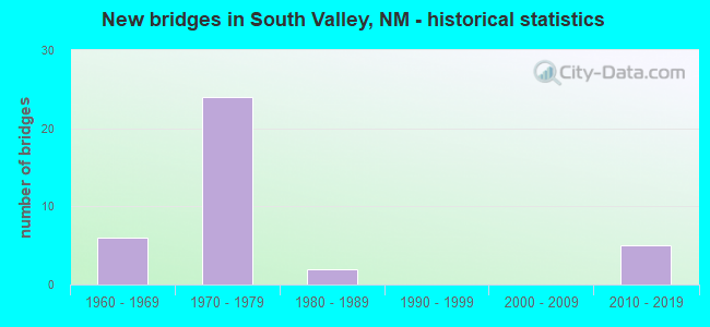
- New bridges - historical statistics
- 61960-1969
- 241970-1979
- 21980-1989
- 52010-2019

- Reconstructed bridges - Historical Statistics
- 61980-1989
- 51990-1999


- Bridge Condition - Deck
- 53.6%Good
- 32.1%Satisfactory
- 14.3%Fair

- Bridge Condition - Superstructure
- 57.1%Good
- 25.0%Satisfactory
- 17.9%Fair

- Bridge Condition - Substructure
- 39.3%Good
- 21.4%Satisfactory
- 39.3%Fair

- Bridge Condition - Channel
- 5.3%Very good
- 57.9%Good
- 26.3%Satisfactory
- 10.5%Fair
Find on map >> Show street view
Structure Number: 6224, Location: 1.9 M W JCT I-25/NM-500 (Lat: 35.027156, Lng: -106.671744), Route carried "on" structure: State highway 500, Year Built: 1961, Year Reconstructed: 1985, Status: Open, Structure Length: 43.13m (141.50ft), Average Daily Traffic: 25,221 (year 2020), Truck Traffic: 7%, Average Future Daily Traffic: 35,492 (year 2040), Design Load: H 15, Features Intersected: RIO GRANDE
Minimum Vertical Clearance: 30+ m (98+ ft), Kilometerpoint: 3.879, Lanes on structure: 2, Base Highway Network: Yes, Owner: State Highway Agency, Approaching Roadway Width: 10.7m (35.1ft), Skew: 20 degrees, Material/Design: Prestressed concrete, Design/Construction: Stringer/Multi-beam, Number Of Spans In Main Unit: 25, Length of Maximum Span: 16.8m (55.1ft), Curb or Sidewalk Widths: Left: 0.0m, Right: 1.3m (4.3ft), Curb-To-Curb Width: 10.7m (35.1ft), Out-to-Out Width: 13.1m (43.0ft)
Condition: Deck: Fair, Superstructure: Satisfactory, Substructure: Fair, Channel: Good, Operating Rating: 51.8 metric tons, Method Used To Determine Operating Rating: Load Factor (LF), Inventory Rating: 32.4 metric tons, Method Used To Determine Inventory Rating: Load Factor (LF), Structural Evaluation: Somewhat better than minimum adequacy, Deck Geometry: Somewhat better than minimum adequacy, Waterway Adequacy: Superior to present desirable criteria, Approach Roadway Alignment: Equal to present desirable criteria, Length Of Structure Improvement: 43.13m (141.50ft), Designated Inspection Frequency: Every 24 months, Inspection Date: May 2020, Bridge Improvement Cost: $1,570,000, Roadway Improvement Cost: $400,000, Total Project Cost: $2,140,000 ( Estimate for 2020), Deck Structure Type: Concrete Cast-file-Place, Wearing Surface/Protective System: Wearing Surface: Epoxy Overlay
Find on map >> Show street view
Structure Number: 6225, Location: 1.29 MW Jct NM-500/NM-47 (Lat: 35.027142, Lng: -106.669025), Route carried "on" structure: State highway 500, Year Built: 1961, Year Reconstructed: 1985, Status: Open, Structure Length: 2.99m (9.81ft), Average Daily Traffic: 25,221 (year 2020), Truck Traffic: 7%, Average Future Daily Traffic: 35,492 (year 2040), Design Load: HS 20, Features Intersected: RIVERSIDE DRAIN/LEVEE RD
Minimum Vertical Clearance: 3.02m (9.91ft), Kilometerpoint: 4.104, Lanes on structure: 2, Base Highway Network: Yes, Owner: State Highway Agency, Approaching Roadway Width: 10.5m (34.4ft), Skew: 20 degrees, Material/Design: Concrete continuous, Design/Construction: Slab, Number Of Spans In Main Unit: 3, Length of Maximum Span: 11.0m (36.1ft), Curb or Sidewalk Widths: Left: 0.0m, Right: 1.3m (4.3ft), Curb-To-Curb Width: 10.8m (35.4ft), Out-to-Out Width: 13.4m (44.0ft)
Condition: Deck: Fair, Superstructure: Fair, Substructure: Fair, Channel: Satisfactory, Operating Rating: 40.3 metric tons, Method Used To Determine Operating Rating: Load Factor (LF), Inventory Rating: 24.1 metric tons, Method Used To Determine Inventory Rating: Load Factor (LF), Structural Evaluation: Somewhat better than minimum adequacy, Deck Geometry: Somewhat better than minimum adequacy, Waterway Adequacy: Equal to present desirable criteria, Approach Roadway Alignment: Equal to present desirable criteria, Length Of Structure Improvement: 2.99m (9.81ft), Designated Inspection Frequency: Every 24 months, Inspection Date: May 2020, Bridge Improvement Cost: $207,000, Roadway Improvement Cost: $20,000, Total Project Cost: $311,000 ( Estimate for 2020), Deck Structure Type: Concrete Cast-file-Place, Wearing Surface/Protective System: Wearing Surface: Epoxy Overlay, Deck Protection: Epoxy Coated Reinforcing
Find on map >> Show street view
Structure Number: 7107, Location: 1.7 MI S JCT NM-47/NM-500 (Lat: 35.001467, Lng: -106.651600), Route carried "on" structure: State highway 47, Year Built: 1969, Status: Open, Structure Length: 3.26m (10.70ft), Average Daily Traffic: 11,429 (year 2020), Truck Traffic: 7%, Average Future Daily Traffic: 16,083 (year 2040), Design Load: HS 20, Features Intersected: TIJERAS ARROYO
Minimum Vertical Clearance: 30+ m (98+ ft), Kilometerpoint: 71.294, Lanes on structure: 4, Base Highway Network: Yes, Owner: State Highway Agency, Approaching Roadway Width: 15.1m (49.5ft), Skew: 4 degrees, Material/Design: Prestressed concrete, Design/Construction: Stringer/Multi-beam, Number Of Spans In Main Unit: 1, Length of Maximum Span: 31.7m (104.0ft), Curb-To-Curb Width: 14.9m (48.9ft), Out-to-Out Width: 15.9m (52.2ft)
Condition: Deck: Satisfactory, Superstructure: Fair, Substructure: Fair, Channel: Good, Operating Rating: 62.9 metric tons, Method Used To Determine Operating Rating: Load Factor (LF), Inventory Rating: 34.6 metric tons, Method Used To Determine Inventory Rating: Load Factor (LF), Structural Evaluation: Somewhat better than minimum adequacy, Deck Geometry: High priority of replacement, Waterway Adequacy: Superior to present desirable criteria, Approach Roadway Alignment: Equal to present desirable criteria, Length Of Structure Improvement: 3.26m (10.70ft), Designated Inspection Frequency: Every 24 months, Inspection Date: March 2021, Bridge Improvement Cost: $460,000, Roadway Improvement Cost: $96,000, Total Project Cost: $740,000 ( Estimate for 2030), Deck Structure Type: Concrete Cast-file-Place, Wearing Surface/Protective System: Wearing Surface: Epoxy Overlay
Find on map >> Show street view
Structure Number: 7109, Location: 0.2 MI N JCT NM-47/NM-500 (Lat: 35.028383, Lng: -106.646242), Route carried "on" structure: State highway 47, Year Built: 1969, Status: Open, Structure Length: 4.33m (14.21ft), Average Daily Traffic: 7,400 (year 2020), Truck Traffic: 7%, Average Future Daily Traffic: 10,414 (year 2040), Design Load: HS 20, Features Intersected: SOUTH DIVERSION CHANNEL
Minimum Vertical Clearance: 30+ m (98+ ft), Kilometerpoint: 68.558, Lanes on structure: 4, Base Highway Network: Yes, Owner: State Highway Agency, Approaching Roadway Width: 14.9m (48.9ft), Skew: 3 degrees, Material/Design: Prestressed concrete, Design/Construction: Stringer/Multi-beam, Number Of Spans In Main Unit: 2, Length of Maximum Span: 20.4m (66.9ft), Curb-To-Curb Width: 15.1m (49.5ft), Out-to-Out Width: 15.8m (51.8ft)
Condition: Deck: Fair, Superstructure: Fair, Substructure: Fair, Channel: Good, Operating Rating: 53.5 metric tons, Method Used To Determine Operating Rating: Load Factor (LF), Inventory Rating: 32.4 metric tons, Method Used To Determine Inventory Rating: Load Factor (LF), Structural Evaluation: Somewhat better than minimum adequacy, Deck Geometry: High priority of corrective action, Waterway Adequacy: Equal to present desirable criteria, Approach Roadway Alignment: Equal to present desirable criteria, Length Of Structure Improvement: 4.33m (14.21ft), Designated Inspection Frequency: Every 24 months, Inspection Date: April 2021, Bridge Improvement Cost: $610,000, Roadway Improvement Cost: $76,000, Total Project Cost: $930,000 ( Estimate for 2030), Deck Structure Type: Concrete Cast-file-Place
Find on map >> Show street view
Structure Number: 7319, Location: 9.3 M N Jct NM-6/I-25 (Lat: 34.940033, Lng: -106.706400), Route carried "on" structure: Interstate 25, Year Built: 1973, Status: Open, Structure Length: 8.38m (27.49ft), Average Daily Traffic: 32,715 (year 2020), Truck Traffic: 13%, Average Future Daily Traffic: 60,288 (year 2040), Design Load: HS 20, Features Intersected: NM-45/S Coors Road
Minimum Vertical Clearance: 30+ m (98+ ft), Kilometerpoint: 342.130, Lanes on structure: 2, Lanes under structure: 2, Base Highway Network: Yes, Owner: State Highway Agency, Approaching Roadway Width: 13.1m (43.0ft), Skew: 2 degrees, Material/Design: Prestressed concrete, Design/Construction: Stringer/Multi-beam, Number Of Spans In Main Unit: 3, Length of Maximum Span: 28.0m (91.9ft), Curb-To-Curb Width: 13.2m (43.3ft), Out-to-Out Width: 13.7m (44.9ft)
Condition: Deck: Satisfactory, Superstructure: Good, Substructure: Fair, Operating Rating: 53.9 metric tons, Method Used To Determine Operating Rating: Load Factor (LF), Inventory Rating: 32.7 metric tons, Method Used To Determine Inventory Rating: Load Factor (LF), Structural Evaluation: Somewhat better than minimum adequacy, Deck Geometry: Superior to present desirable criteria, Underclear: Better than present minimum criteria, Approach Roadway Alignment: Equal to present desirable criteria, Designated Inspection Frequency: Every 24 months, Inspection Date: Febuary 2022, Deck Structure Type: Concrete Cast-file-Place, Wearing Surface/Protective System: Wearing Surface: Epoxy Overlay
Find on map >> Show street view
Structure Number: 732, Location: 9.3 M N Jct I-25/NM-6 (Lat: 34.940258, Lng: -106.706542), Route carried "on" structure: Interstate 25, Year Built: 1973, Status: Open, Structure Length: 8.23m (27.00ft), Average Daily Traffic: 32,715 (year 2020), Truck Traffic: 13%, Average Future Daily Traffic: 60,288 (year 2040), Design Load: HS 20, Features Intersected: NM-45/S Coors Road
Minimum Vertical Clearance: 30+ m (98+ ft), Kilometerpoint: 342.147, Lanes on structure: 2, Lanes under structure: 2, Base Highway Network: Yes, Owner: State Highway Agency, Approaching Roadway Width: 12.9m (42.3ft), Skew: 12 degrees, Material/Design: Prestressed concrete, Design/Construction: Stringer/Multi-beam, Number Of Spans In Main Unit: 3, Length of Maximum Span: 26.2m (86.0ft), Curb-To-Curb Width: 13.2m (43.3ft), Out-to-Out Width: 13.7m (44.9ft)
Condition: Deck: Good, Superstructure: Satisfactory, Substructure: Satisfactory, Operating Rating: 53.9 metric tons, Method Used To Determine Operating Rating: Load Factor (LF), Inventory Rating: 32.7 metric tons, Method Used To Determine Inventory Rating: Load Factor (LF), Structural Evaluation: Equal to present minimum criteria, Deck Geometry: Superior to present desirable criteria, Underclear: Equal to present desirable criteria, Approach Roadway Alignment: Equal to present desirable criteria, Designated Inspection Frequency: Every 24 months, Inspection Date: Febuary 2022, Deck Structure Type: Concrete Cast-file-Place, Wearing Surface/Protective System: Wearing Surface: Latex Concrete, Deck Protection: Epoxy Coated Reinforcing
Find on map >> Show street view
Structure Number: 7321, Location: 9.9 Mi N Jct I-25 / NM-6 (Lat: 34.946653, Lng: -106.699253), Route carried "on" structure: Interstate 25, Year Built: 1973, Year Reconstructed: 1996, Status: Open, Structure Length: 3.84m (12.60ft), Average Daily Traffic: 32,715 (year 2020), Truck Traffic: 13%, Average Future Daily Traffic: 60,288 (year 2040), Design Load: HS 20, Features Intersected: Arenal Canal
Minimum Vertical Clearance: 30+ m (98+ ft), Kilometerpoint: 343.112, Lanes on structure: 2, Base Highway Network: Yes, Owner: State Highway Agency, Approaching Roadway Width: 18.0m (59.1ft), Skew: 12 degrees, Material/Design: Prestressed concrete continuous, Design/Construction: Stringer/Multi-beam, Number Of Spans In Main Unit: 3, Length of Maximum Span: 17.4m (57.1ft), Curb-To-Curb Width: 12.9m (42.3ft), Out-to-Out Width: 13.7m (44.9ft)
Condition: Deck: Good, Superstructure: Good, Substructure: Good, Channel: Fair, Operating Rating: 53.9 metric tons, Method Used To Determine Operating Rating: Load Factor (LF), Inventory Rating: 32.7 metric tons, Method Used To Determine Inventory Rating: Load Factor (LF), Structural Evaluation: Better than present minimum criteria, Deck Geometry: Superior to present desirable criteria, Waterway Adequacy: Equal to present desirable criteria, Approach Roadway Alignment: Equal to present desirable criteria, Length Of Structure Improvement: 3.84m (12.60ft), Designated Inspection Frequency: Every 24 months, Inspection Date: September 2020, Bridge Improvement Cost: $140,000, Roadway Improvement Cost: $104,000, Total Project Cost: $300,000 ( Estimate for 2020), Deck Structure Type: Concrete Cast-file-Place, Wearing Surface/Protective System: Wearing Surface: Epoxy Overlay, Membrane: Epoxy, Deck Protection: Epoxy Coated Reinforcing
Find on map >> Show street view
Structure Number: 7322, Location: 9.9 Mi N Jct I-25/NM-6 (Lat: 34.946925, Lng: -106.699331), Route carried "on" structure: Interstate 25, Year Built: 1973, Year Reconstructed: 1990, Status: Open, Structure Length: 3.90m (12.80ft), Average Daily Traffic: 32,715 (year 2020), Truck Traffic: 13%, Average Future Daily Traffic: 60,288 (year 2040), Design Load: HS 20, Features Intersected: Arenal Canal
Minimum Vertical Clearance: 30+ m (98+ ft), Kilometerpoint: 343.112, Lanes on structure: 2, Base Highway Network: Yes, Owner: State Highway Agency, Approaching Roadway Width: 12.9m (42.3ft), Skew: 12 degrees, Material/Design: Prestressed concrete, Design/Construction: Stringer/Multi-beam, Number Of Spans In Main Unit: 3, Length of Maximum Span: 17.1m (56.1ft), Curb-To-Curb Width: 13.0m (42.7ft), Out-to-Out Width: 13.7m (44.9ft)
Condition: Deck: Good, Superstructure: Good, Substructure: Satisfactory, Channel: Good, Operating Rating: 53.9 metric tons, Method Used To Determine Operating Rating: Load Factor (LF), Inventory Rating: 28.6 metric tons, Method Used To Determine Inventory Rating: Load Factor (LF), Structural Evaluation: Equal to present minimum criteria, Deck Geometry: Superior to present desirable criteria, Waterway Adequacy: Equal to present desirable criteria, Approach Roadway Alignment: Equal to present desirable criteria, Designated Inspection Frequency: Every 24 months, Inspection Date: September 2020, Deck Structure Type: Concrete Cast-file-Place, Wearing Surface/Protective System: Wearing Surface: Epoxy Overlay, Membrane: Epoxy, Deck Protection: Epoxy Coated Reinforcing
Find on map >> Show street view
Structure Number: 7323, Location: 2 M. S. of Jct I-25/NM-47 (Lat: 34.948272, Lng: -106.693722), Route carried "on" structure: Interstate 25, Year Built: 1972, Status: Open, Structure Length: 5.67m (18.60ft), Average Daily Traffic: 27,583 (year 2020), Truck Traffic: 13%, Average Future Daily Traffic: 50,831 (year 2040), Design Load: HS 20, Features Intersected: NM-314 Isleta Blvd.
Minimum Vertical Clearance: 30+ m (98+ ft), Kilometerpoint: 343.595, Lanes on structure: 2, Lanes under structure: 4, Base Highway Network: Yes, Owner: State Highway Agency, Approaching Roadway Width: 13.2m (43.3ft), Skew: 10 degrees, Material/Design: Steel, Design/Construction: Stringer/Multi-beam, Number Of Spans In Main Unit: 3, Length of Maximum Span: 31.3m (102.7ft), Curb-To-Curb Width: 12.5m (41.0ft), Out-to-Out Width: 13.7m (44.9ft)
Condition: Deck: Good, Superstructure: Good, Substructure: Good, Operating Rating: 50.2 metric tons, Method Used To Determine Operating Rating: Load Factor (LF), Inventory Rating: 32.4 metric tons, Method Used To Determine Inventory Rating: Load Factor (LF), Structural Evaluation: Better than present minimum criteria, Deck Geometry: Better than present minimum criteria, Underclear: Equal to present minimum criteria, Approach Roadway Alignment: Equal to present desirable criteria, Length Of Structure Improvement: 5.67m (18.60ft), Designated Inspection Frequency: Every 24 months, Other Special Inspection Frequency: Every 60 months, Inspection Date: October 2020, Other Special Inspection Date: October 2020, Bridge Improvement Cost: $320,000, Roadway Improvement Cost: $200,000, Total Project Cost: $550,000 ( Estimate for 2030), Deck Structure Type: Concrete Cast-file-Place, Wearing Surface/Protective System: Wearing Surface: Latex Concrete, Deck Protection: Epoxy Coated Reinforcing
Find on map >> Show street view
Structure Number: 7324, Location: 2 M S Jct I-25/NM-47 (Lat: 34.948517, Lng: -106.693797), Route carried "on" structure: Interstate 25, Year Built: 1972, Year Reconstructed: 1996, Status: Open, Structure Length: 5.67m (18.60ft), Average Daily Traffic: 27,583 (year 2020), Truck Traffic: 13%, Average Future Daily Traffic: 50,831 (year 2040), Design Load: HS 20, Features Intersected: NM-314 (Isleta Blvd)
Minimum Vertical Clearance: 30+ m (98+ ft), Kilometerpoint: 343.595, Lanes on structure: 2, Lanes under structure: 5, Base Highway Network: Yes, Owner: State Highway Agency, Approaching Roadway Width: 12.8m (42.0ft), Skew: 10 degrees, Material/Design: Steel, Design/Construction: Stringer/Multi-beam, Number Of Spans In Main Unit: 3, Length of Maximum Span: 31.4m (103.0ft), Curb-To-Curb Width: 12.8m (42.0ft), Out-to-Out Width: 13.7m (44.9ft)
Condition: Deck: Good, Superstructure: Good, Substructure: Good, Operating Rating: 50.2 metric tons, Method Used To Determine Operating Rating: Load Factor (LF), Inventory Rating: 32.4 metric tons, Method Used To Determine Inventory Rating: Load Factor (LF), Structural Evaluation: Better than present minimum criteria, Deck Geometry: Equal to present desirable criteria, Underclear: Somewhat better than minimum adequacy, Approach Roadway Alignment: Equal to present desirable criteria, Length Of Structure Improvement: 5.67m (18.60ft), Designated Inspection Frequency: Every 24 months, Other Special Inspection Frequency: Every 60 months, Inspection Date: October 2020, Other Special Inspection Date: October 2020, Bridge Improvement Cost: $310,000, Roadway Improvement Cost: $96,000, Total Project Cost: $530,000 ( Estimate for 2030), Deck Structure Type: Concrete Cast-file-Place, Wearing Surface/Protective System: Deck Protection: Epoxy Coated Reinforcing
Find on map >> Show street view
Structure Number: 7325, Location: 10.4 M N Jct I-25/NM-6 (Lat: 34.948808, Lng: -106.689694), Route carried "on" structure: Interstate 25, Year Built: 1972, Status: Open, Structure Length: 3.69m (12.11ft), Average Daily Traffic: 27,583 (year 2020), Truck Traffic: 13%, Average Future Daily Traffic: 50,831 (year 2040), Design Load: HS 20, Features Intersected: Isleta Indian Lateral.
Minimum Vertical Clearance: 30+ m (98+ ft), Kilometerpoint: 344.029, Lanes on structure: 2, Base Highway Network: Yes, Owner: State Highway Agency, Approaching Roadway Width: 16.5m (54.1ft), Skew: 10 degrees, Material/Design: Prestressed concrete continuous, Design/Construction: Stringer/Multi-beam, Number Of Spans In Main Unit: 3, Length of Maximum Span: 17.4m (57.1ft), Curb-To-Curb Width: 15.7m (51.5ft), Out-to-Out Width: 15.9m (52.2ft)
Condition: Deck: Satisfactory, Superstructure: Good, Substructure: Satisfactory, Channel: Satisfactory, Operating Rating: 53.5 metric tons, Method Used To Determine Operating Rating: Load Factor (LF), Inventory Rating: 32.4 metric tons, Method Used To Determine Inventory Rating: Load Factor (LF), Structural Evaluation: Equal to present minimum criteria, Deck Geometry: Superior to present desirable criteria, Waterway Adequacy: Equal to present desirable criteria, Approach Roadway Alignment: Equal to present desirable criteria, Designated Inspection Frequency: Every 24 months, Inspection Date: Febuary 2022, Deck Structure Type: Concrete Cast-file-Place, Wearing Surface/Protective System: Deck Protection: Epoxy Coated Reinforcing
Find on map >> Show street view
Structure Number: 7326, Location: 10.4 M N Jct NM-6/I-25 (Lat: 34.949053, Lng: -106.689714), Route carried "on" structure: Interstate 25, Year Built: 1972, Year Reconstructed: 1996, Status: Open, Structure Length: 3.69m (12.11ft), Average Daily Traffic: 27,583 (year 2020), Truck Traffic: 13%, Average Future Daily Traffic: 50,831 (year 2040), Design Load: HS 20, Features Intersected: Isleta Indian Lateral
Minimum Vertical Clearance: 30+ m (98+ ft), Kilometerpoint: 344.029, Lanes on structure: 2, Base Highway Network: Yes, Owner: State Highway Agency, Approaching Roadway Width: 13.9m (45.6ft), Skew: 10 degrees, Material/Design: Prestressed concrete, Design/Construction: Stringer/Multi-beam, Number Of Spans In Main Unit: 3, Length of Maximum Span: 17.4m (57.1ft), Curb-To-Curb Width: 15.8m (51.8ft), Out-to-Out Width: 15.8m (51.8ft)
Condition: Deck: Satisfactory, Superstructure: Satisfactory, Substructure: Good, Channel: Satisfactory, Operating Rating: 53.5 metric tons, Method Used To Determine Operating Rating: Load Factor (LF), Inventory Rating: 32.4 metric tons, Method Used To Determine Inventory Rating: Load Factor (LF), Structural Evaluation: Equal to present minimum criteria, Deck Geometry: Superior to present desirable criteria, Waterway Adequacy: Equal to present desirable criteria, Approach Roadway Alignment: Equal to present desirable criteria, Designated Inspection Frequency: Every 24 months, Inspection Date: Febuary 2022, Deck Structure Type: Concrete Cast-file-Place, Wearing Surface/Protective System: Wearing Surface: Epoxy Overlay, Deck Protection: Epoxy Coated Reinforcing
Find on map >> Show street view
Structure Number: 7354, Location: 11.0 M N Jct NM-6/I-25 (Lat: 34.949867, Lng: -106.681653), Route carried "on" structure: Interstate 25, Year Built: 1973, Year Reconstructed: 1991, Status: Open, Structure Length: 70.53m (231.40ft), Average Daily Traffic: 28,491 (year 2020), Truck Traffic: 13%, Average Future Daily Traffic: 55,174 (year 2040), Design Load: HS 20, Features Intersected: Rio Grande,IrriI. Canal
Minimum Vertical Clearance: 30+ m (98+ ft), Kilometerpoint: 344.786, Lanes on structure: 2, Base Highway Network: Yes, Owner: State Highway Agency, Approaching Roadway Width: 12.8m (42.0ft), Skew: 10 degrees, Material/Design: Prestressed concrete, Design/Construction: Stringer/Multi-beam, Number Of Spans In Main Unit: 32, Length of Maximum Span: 25.6m (84.0ft), Curb-To-Curb Width: 12.8m (42.0ft), Out-to-Out Width: 13.7m (44.9ft)
Condition: Deck: Good, Superstructure: Good, Substructure: Fair, Channel: Good, Operating Rating: 53.9 metric tons, Method Used To Determine Operating Rating: Load Factor (LF), Inventory Rating: 25.5 metric tons, Method Used To Determine Inventory Rating: Load Factor (LF), Structural Evaluation: Somewhat better than minimum adequacy, Deck Geometry: Equal to present desirable criteria, Waterway Adequacy: Equal to present desirable criteria, Approach Roadway Alignment: Equal to present desirable criteria, Designated Inspection Frequency: Every 6 months, Inspection Date: November 2021, Deck Structure Type: Concrete Cast-file-Place, Wearing Surface/Protective System: Wearing Surface: Latex Concrete, Deck Protection: Epoxy Coated Reinforcing
Find on map >> Show street view
Structure Number: 7355, Location: 11.0 M N Jct NM-6/I-25 (Lat: 34.950100, Lng: -106.681700), Route carried "on" structure: Interstate 25, Year Built: 1973, Year Reconstructed: 1991, Status: Open, Structure Length: 70.13m (230.09ft), Average Daily Traffic: 28,491 (year 2020), Truck Traffic: 13%, Average Future Daily Traffic: 55,174 (year 2040), Design Load: HS 20, Features Intersected: Rio Grande,Irri. Canal
Minimum Vertical Clearance: 30+ m (98+ ft), Kilometerpoint: 344.786, Lanes on structure: 2, Base Highway Network: Yes, Owner: State Highway Agency, Approaching Roadway Width: 12.7m (41.7ft), Skew: 10 degrees, Material/Design: Prestressed concrete, Design/Construction: Stringer/Multi-beam, Number Of Spans In Main Unit: 32, Length of Maximum Span: 26.8m (87.9ft), Curb-To-Curb Width: 12.9m (42.3ft), Out-to-Out Width: 13.7m (44.9ft)
Condition: Deck: Satisfactory, Superstructure: Good, Substructure: Fair, Channel: Good, Operating Rating: 53.9 metric tons, Method Used To Determine Operating Rating: Load Factor (LF), Inventory Rating: 25.9 metric tons, Method Used To Determine Inventory Rating: Load Factor (LF), Structural Evaluation: Somewhat better than minimum adequacy, Deck Geometry: Superior to present desirable criteria, Waterway Adequacy: Equal to present desirable criteria, Approach Roadway Alignment: Equal to present desirable criteria, Designated Inspection Frequency: Every 6 months, Inspection Date: November 2021, Deck Structure Type: Concrete Cast-file-Place, Wearing Surface/Protective System: Wearing Surface: Latex Concrete, Deck Protection: Epoxy Coated Reinforcing
Find on map >> Show street view
Structure Number: 7356, Location: 11.5 M N Jct NM-6/I-25 (Lat: 34.951081, Lng: -106.672386), Route carried "on" structure: Interstate 25, Year Built: 1973, Year Reconstructed: 1993, Status: Open, Structure Length: 5.06m (16.60ft), Average Daily Traffic: 28,491 (year 2020), Truck Traffic: 13%, Average Future Daily Traffic: 55,174 (year 2040), Design Load: HS 20, Features Intersected: BNSF Railroad
Minimum Vertical Clearance: 30+ m (98+ ft), Kilometerpoint: 345.623, Lanes on structure: 2, Base Highway Network: Yes, Owner: State Highway Agency, Approaching Roadway Width: 12.8m (42.0ft), Skew: 11 degrees, Material/Design: Prestressed concrete, Design/Construction: Stringer/Multi-beam, Number Of Spans In Main Unit: 3, Length of Maximum Span: 18.3m (60.0ft), Curb-To-Curb Width: 12.8m (42.0ft), Out-to-Out Width: 13.7m (44.9ft)
Condition: Deck: Good, Superstructure: Good, Substructure: Fair, Operating Rating: 48.8 metric tons, Method Used To Determine Operating Rating: Load Factor (LF), Inventory Rating: 22.9 metric tons, Method Used To Determine Inventory Rating: Load Factor (LF), Structural Evaluation: Somewhat better than minimum adequacy, Deck Geometry: Equal to present desirable criteria, Underclear: Equal to present minimum criteria, Approach Roadway Alignment: Equal to present desirable criteria, Designated Inspection Frequency: Every 24 months, Inspection Date: May 2020, Deck Structure Type: Concrete Cast-file-Place, Wearing Surface/Protective System: Wearing Surface: Latex Concrete, Deck Protection: Epoxy Coated Reinforcing
Find on map >> Show street view
Structure Number: 7357, Location: 11.5 M N Jct NM-6/I-25 (Lat: 34.951328, Lng: -106.672358), Route carried "on" structure: Interstate 25, Year Built: 1973, Year Reconstructed: 1993, Status: Open, Structure Length: 5.06m (16.60ft), Average Daily Traffic: 28,491 (year 2020), Truck Traffic: 13%, Average Future Daily Traffic: 55,174 (year 2040), Design Load: HS 20, Features Intersected: BNSF Railroad
Minimum Vertical Clearance: 30+ m (98+ ft), Kilometerpoint: 345.623, Lanes on structure: 2, Base Highway Network: Yes, Owner: State Highway Agency, Approaching Roadway Width: 13.1m (43.0ft), Skew: 11 degrees, Material/Design: Prestressed concrete, Design/Construction: Stringer/Multi-beam, Number Of Spans In Main Unit: 3, Length of Maximum Span: 18.3m (60.0ft), Curb-To-Curb Width: 12.8m (42.0ft), Out-to-Out Width: 13.7m (44.9ft)
Condition: Deck: Good, Superstructure: Satisfactory, Substructure: Fair, Operating Rating: 48.8 metric tons, Method Used To Determine Operating Rating: Load Factor (LF), Inventory Rating: 22.9 metric tons, Method Used To Determine Inventory Rating: Load Factor (LF), Structural Evaluation: Somewhat better than minimum adequacy, Deck Geometry: Equal to present desirable criteria, Underclear: Better than present minimum criteria, Approach Roadway Alignment: Equal to present desirable criteria, Designated Inspection Frequency: Every 24 months, Inspection Date: May 2020, Deck Structure Type: Concrete Cast-file-Place, Wearing Surface/Protective System: Wearing Surface: Latex Concrete, Deck Protection: Epoxy Coated Reinforcing
Find on map >> Show street view
Structure Number: 7361, Location: South Broadway Interchang (Lat: 34.953900, Lng: -106.662000), Route carried "on" structure: Interstate 25, Year Built: 1973, Year Reconstructed: 1990, Status: Open, Structure Length: 9.20m (30.18ft), Average Daily Traffic: 48,628 (year 2020), Truck Traffic: 13%, Average Future Daily Traffic: 89,613 (year 2040), Design Load: HS 20, Features Intersected: NM-47 NBL
Minimum Vertical Clearance: 30+ m (98+ ft), Kilometerpoint: 346.604, Lanes on structure: 2, Lanes under structure: 2, Base Highway Network: Yes, Owner: State Highway Agency, Approaching Roadway Width: 13.0m (42.7ft), Skew: 5 degrees, Material/Design: Steel, Design/Construction: Stringer/Multi-beam, Number Of Spans In Main Unit: 3, Length of Maximum Span: 42.1m (138.1ft), Curb-To-Curb Width: 13.0m (42.7ft), Out-to-Out Width: 14.0m (45.9ft)
Condition: Deck: Good, Superstructure: Good, Substructure: Good, Operating Rating: 53.5 metric tons, Method Used To Determine Operating Rating: Load Factor (LF), Inventory Rating: 31.8 metric tons, Method Used To Determine Inventory Rating: Load Factor (LF), Structural Evaluation: Better than present minimum criteria, Deck Geometry: Superior to present desirable criteria, Underclear: Superior to present desirable criteria, Approach Roadway Alignment: Better than present minimum criteria, Designated Inspection Frequency: Every 24 months, Inspection Date: April 2021, Deck Structure Type: Concrete Cast-file-Place, Wearing Surface/Protective System: Wearing Surface: Latex Concrete, Deck Protection: Epoxy Coated Reinforcing
Find on map >> Show street view
Structure Number: 7362, Location: NM-47 NB Over I-25 Ramp (Lat: 34.955408, Lng: -106.661744), Route carried "on" structure: State highway 47, Year Built: 1973, Status: Open, Structure Length: 4.91m (16.11ft), Average Daily Traffic: 6,669 (year 2020), Truck Traffic: 7%, Average Future Daily Traffic: 9,385 (year 2040), Design Load: HS 20, Features Intersected: I-25 Exit Ramp to NM47 S
Minimum Vertical Clearance: 30+ m (98+ ft), Kilometerpoint: 66.949, Lanes on structure: 3, Lanes under structure: 1, Base Highway Network: Yes, Owner: State Highway Agency, Approaching Roadway Width: 16.7m (54.8ft), Skew: 3 degrees, Material/Design: Prestressed concrete, Design/Construction: Stringer/Multi-beam, Number Of Spans In Main Unit: 3, Length of Maximum Span: 18.9m (62.0ft), Curb-To-Curb Width: 16.6m (54.5ft), Out-to-Out Width: 17.4m (57.1ft)
Condition: Deck: Satisfactory, Superstructure: Fair, Substructure: Satisfactory, Operating Rating: 53.5 metric tons, Method Used To Determine Operating Rating: Load Factor (LF), Inventory Rating: 32.4 metric tons, Method Used To Determine Inventory Rating: Load Factor (LF), Structural Evaluation: Somewhat better than minimum adequacy, Deck Geometry: Equal to present desirable criteria, Underclear: Somewhat better than minimum adequacy, Approach Roadway Alignment: Equal to present desirable criteria, Designated Inspection Frequency: Every 12 months, Inspection Date: September 2021, Deck Structure Type: Concrete Cast-file-Place, Wearing Surface/Protective System: Wearing Surface: Epoxy Overlay, Deck Protection: Epoxy Coated Reinforcing
Find on map >> Show street view
Structure Number: 7376, Location: 3.5 MI N OF JCT NM-47 (Lat: 34.998928, Lng: -106.645825), Route carried "on" structure: City street 5042, Year Built: 1973, Status: Open, Structure Length: 9.45m (31.00ft), Average Daily Traffic: 441 (year 2020), Truck Traffic: 6%, Average Future Daily Traffic: 718 (year 2040), Design Load: HS 20, Features Intersected: I-25 NBLS/SBLS
Minimum Vertical Clearance: 30+ m (98+ ft), Kilometerpoint: 0.575, Lanes on structure: 3, Lanes under structure: 4, Owner: State Highway Agency, Approaching Roadway Width: 12.2m (40.0ft), Material/Design: Prestressed concrete, Design/Construction: Stringer/Multi-beam, Number Of Spans In Main Unit: 5, Length of Maximum Span: 26.2m (86.0ft), Curb-To-Curb Width: 12.2m (40.0ft), Out-to-Out Width: 13.1m (43.0ft)
Condition: Deck: Good, Superstructure: Satisfactory, Substructure: Satisfactory, Operating Rating: 53.5 metric tons, Method Used To Determine Operating Rating: Load Factor (LF), Inventory Rating: 32.4 metric tons, Method Used To Determine Inventory Rating: Load Factor (LF), Structural Evaluation: Equal to present minimum criteria, Deck Geometry: Meets minimum limits, Underclear: Somewhat better than minimum adequacy, Approach Roadway Alignment: Equal to present desirable criteria, Designated Inspection Frequency: Every 24 months, Inspection Date: March 2022, Deck Structure Type: Concrete Cast-file-Place, Wearing Surface/Protective System: Wearing Surface: Epoxy Overlay, Deck Protection: Epoxy Coated Reinforcing
Find on map >> Show street view
Structure Number: 743, Location: 0.6 MI N OF JCT NM-47 (Lat: 34.960586, Lng: -106.657808), Route carried "on" structure: Interstate 25, Year Built: 1973, Status: Open, Structure Length: 1.01m (3.31ft), Average Daily Traffic: 42,047 (year 2020), Truck Traffic: 13%, Average Future Daily Traffic: 77,485 (year 2040), Design Load: HS 20, Features Intersected: UNNAMED WATERWAY
Minimum Vertical Clearance: 30+ m (98+ ft), Kilometerpoint: 347.522, Lanes on structure: 5, Base Highway Network: Yes, Owner: State Highway Agency, Approaching Roadway Width: 26.8m (87.9ft), Skew: 11 degrees, Material/Design: Concrete continuous, Design/Construction: Culvert, Number Of Spans In Main Unit: 3, Length of Maximum Span: 3.0m (9.8ft)
Condition: Channel: Good, Culverts: Satisfactory, Operating Rating: 37.3 metric tons, Method Used To Determine Operating Rating: Load Factor (LF), Inventory Rating: 32.4 metric tons, Method Used To Determine Inventory Rating: Load Factor (LF), Structural Evaluation: Equal to present minimum criteria, Waterway Adequacy: Equal to present minimum criteria, Approach Roadway Alignment: Equal to present desirable criteria, Designated Inspection Frequency: Every 24 months, Inspection Date: August 2020
Find on map >> Show street view
Structure Number: 8568, Location: 1.9 MI W OF JCT I-25 (Lat: 35.027156, Lng: -106.671775), Route carried "on" structure: State highway 500, Year Built: 1985, Status: Open, Structure Length: 43.13m (141.50ft), Average Daily Traffic: 25,221 (year 2020), Truck Traffic: 7%, Average Future Daily Traffic: 35,492 (year 2040), Design Load: HS 20, Features Intersected: RIO GRANDE
Minimum Vertical Clearance: 30+ m (98+ ft), Kilometerpoint: 3.879, Lanes on structure: 2, Base Highway Network: Yes, Owner: State Highway Agency, Approaching Roadway Width: 10.7m (35.1ft), Skew: 20 degrees, Material/Design: Prestressed concrete continuous, Design/Construction: Stringer/Multi-beam, Number Of Spans In Main Unit: 25, Length of Maximum Span: 16.8m (55.1ft), Curb-To-Curb Width: 10.5m (34.4ft), Out-to-Out Width: 11.6m (38.1ft)
Condition: Deck: Satisfactory, Superstructure: Satisfactory, Substructure: Good, Channel: Good, Operating Rating: 53.5 metric tons, Method Used To Determine Operating Rating: Load Factor (LF), Inventory Rating: 32.7 metric tons, Method Used To Determine Inventory Rating: Load Factor (LF), Structural Evaluation: Equal to present minimum criteria, Deck Geometry: Somewhat better than minimum adequacy, Waterway Adequacy: Superior to present desirable criteria, Approach Roadway Alignment: Equal to present desirable criteria, Designated Inspection Frequency: Every 24 months, Inspection Date: May 2020, Deck Structure Type: Concrete Cast-file-Place, Wearing Surface/Protective System: Deck Protection: Epoxy Coated Reinforcing
Find on map >> Show street view
Structure Number: 8569, Location: 1.29 M W Jct NM-500/NM-47 (Lat: 35.027233, Lng: -106.669019), Route carried "on" structure: State highway 500, Year Built: 1985, Status: Open, Structure Length: 2.99m (9.81ft), Average Daily Traffic: 25,221 (year 2020), Truck Traffic: 7%, Average Future Daily Traffic: 35,492 (year 2040), Design Load: HS 20, Features Intersected: RIVERSIDE DRAIN
Minimum Vertical Clearance: 30+ m (98+ ft), Kilometerpoint: 4.104, Lanes on structure: 2, Base Highway Network: Yes, Owner: State Highway Agency, Approaching Roadway Width: 10.5m (34.4ft), Skew: 20 degrees, Material/Design: Concrete continuous, Design/Construction: Slab, Number Of Spans In Main Unit: 3, Length of Maximum Span: 11.0m (36.1ft), Curb-To-Curb Width: 10.5m (34.4ft), Out-to-Out Width: 11.6m (38.1ft)
Condition: Deck: Fair, Superstructure: Fair, Substructure: Fair, Channel: Fair, Operating Rating: 55.8 metric tons, Method Used To Determine Operating Rating: Load Factor (LF), Inventory Rating: 33.4 metric tons, Method Used To Determine Inventory Rating: Load Factor (LF), Structural Evaluation: Somewhat better than minimum adequacy, Deck Geometry: Somewhat better than minimum adequacy, Waterway Adequacy: Equal to present desirable criteria, Approach Roadway Alignment: Equal to present desirable criteria, Designated Inspection Frequency: Every 24 months, Inspection Date: May 2020, Deck Structure Type: Concrete Cast-file-Place, Wearing Surface/Protective System: Deck Protection: Epoxy Coated Reinforcing
Find on map >> Show street view
Structure Number: 8663, Location: 0.22 Mi W of NM-47 (Lat: 35.005978, Lng: -106.654397), Route carried "on" structure: City street 6614, Year Built: 1968, Status: Open, Structure Length: 4.42m (14.50ft), Average Daily Traffic: 267 (year 2020), Average Future Daily Traffic: 487 (year 2040), Design Load: HS 20, Features Intersected: South Diversion Channel, Facility Carried by Structure: Murry Road
Minimum Vertical Clearance: 30+ m (98+ ft), Kilometerpoint: 0.248, Lanes on structure: 2, Owner: City or Municipal Highway Agency, Approaching Roadway Width: 9.6m (31.5ft), Skew: 2 degrees, Material/Design: Prestressed concrete, Design/Construction: Stringer/Multi-beam, Number Of Spans In Main Unit: 2, Length of Maximum Span: 21.0m (68.9ft), Curb-To-Curb Width: 9.6m (31.5ft), Out-to-Out Width: 10.1m (33.1ft)
Condition: Deck: Satisfactory, Superstructure: Satisfactory, Substructure: Satisfactory, Channel: Good, Operating Rating: 53.5 metric tons, Method Used To Determine Operating Rating: Load Factor (LF), Inventory Rating: 32.4 metric tons, Method Used To Determine Inventory Rating: Load Factor (LF), Structural Evaluation: Equal to present minimum criteria, Deck Geometry: Equal to present minimum criteria, Waterway Adequacy: Superior to present desirable criteria, Approach Roadway Alignment: Equal to present desirable criteria, Designated Inspection Frequency: Every 24 months, Inspection Date: September 2020, Deck Structure Type: Concrete Cast-file-Place, Wearing Surface/Protective System: Deck Protection: Epoxy Coated Reinforcing
Find on map >> Show street view
Structure Number: 8664, Location: 0.1 Mi W of NM-47/Brdway (Lat: 35.014797, Lng: -106.649583), Route carried "on" structure: City street 5313, Year Built: 1968, Status: Open, Structure Length: 2.59m (8.50ft), Average Daily Traffic: 3,051 (year 2020), Truck Traffic: 6%, Average Future Daily Traffic: 4,971 (year 2040), Design Load: HS 20, Features Intersected: South Diversion Channel, Facility Carried by Structure: Prosperity Avenue
Minimum Vertical Clearance: 30+ m (98+ ft), Kilometerpoint: 0.000, Lanes on structure: 2, Owner: City or Municipal Highway Agency, Approaching Roadway Width: 9.6m (31.5ft), Material/Design: Prestressed concrete, Design/Construction: Stringer/Multi-beam, Number Of Spans In Main Unit: 1, Length of Maximum Span: 24.7m (81.0ft), Curb or Sidewalk Widths: Left: 1.5m (4.9ft), Right: 0.0m, Curb-To-Curb Width: 9.4m (30.8ft), Out-to-Out Width: 11.3m (37.1ft)
Condition: Deck: Satisfactory, Superstructure: Good, Substructure: Fair, Channel: Satisfactory, Operating Rating: 53.5 metric tons, Method Used To Determine Operating Rating: Load Factor (LF), Inventory Rating: 32.4 metric tons, Method Used To Determine Inventory Rating: Load Factor (LF), Structural Evaluation: Somewhat better than minimum adequacy, Deck Geometry: Meets minimum limits, Waterway Adequacy: Superior to present desirable criteria, Approach Roadway Alignment: Equal to present desirable criteria, Designated Inspection Frequency: Every 24 months, Inspection Date: July 2020, Deck Structure Type: Concrete Cast-file-Place
Find on map >> Show street view
Structure Number: 9673, Location: 1.0 M S Rio Bravo (Lat: 35.009889, Lng: -106.642306), Route carried "on" structure: Interstate 25, Year Built: 2016, Status: Open, Structure Length: 4.02m (13.19ft), Average Daily Traffic: 42,047 (year 2020), Truck Traffic: 13%, Average Future Daily Traffic: 77,485 (year 2040), Design Load: HS 20, Features Intersected: Sandia Railroad Spur.
Minimum Vertical Clearance: 30+ m (98+ ft), Kilometerpoint: 353.090, Lanes on structure: 2, Base Highway Network: Yes, Owner: State Highway Agency, Approaching Roadway Width: 18.6m (61.0ft), Skew: 21 degrees, Material/Design: Prestressed concrete continuous, Design/Construction: Stringer/Multi-beam, Number Of Spans In Main Unit: 2, Length of Maximum Span: 19.4m (63.6ft), Curb-To-Curb Width: 18.4m (60.4ft), Out-to-Out Width: 19.2m (63.0ft)
Condition: Deck: Good, Superstructure: Good, Substructure: Good, Operating Rating: 68.7 metric tons, Method Used To Determine Operating Rating: Load Factor (LF), Inventory Rating: 42.1 metric tons, Method Used To Determine Inventory Rating: Load Factor (LF), Structural Evaluation: Better than present minimum criteria, Deck Geometry: Superior to present desirable criteria, Underclear: Equal to present minimum criteria, Approach Roadway Alignment: Equal to present desirable criteria, Designated Inspection Frequency: Every 24 months, Inspection Date: January 2021, Deck Structure Type: Concrete Cast-file-Place, Wearing Surface/Protective System: Wearing Surface: Epoxy Overlay, Deck Protection: Epoxy Coated Reinforcing
Find on map >> Show street view
Structure Number: 9674, Location: 1.0 M S Jct Rio Bravo (Lat: 35.009694, Lng: -106.641750), Route carried "on" structure: Interstate 25, Year Built: 2016, Status: Open, Structure Length: 4.02m (13.19ft), Average Daily Traffic: 42,047 (year 2020), Truck Traffic: 13%, Average Future Daily Traffic: 77,485 (year 2040), Design Load: HS 20, Features Intersected: Sandia Railroad Spur
Minimum Vertical Clearance: 30+ m (98+ ft), Kilometerpoint: 353.090, Lanes on structure: 2, Base Highway Network: Yes, Owner: State Highway Agency, Approaching Roadway Width: 18.6m (61.0ft), Skew: 21 degrees, Material/Design: Prestressed concrete continuous, Design/Construction: Stringer/Multi-beam, Number Of Spans In Main Unit: 2, Length of Maximum Span: 19.4m (63.6ft), Curb-To-Curb Width: 18.5m (60.7ft), Out-to-Out Width: 19.2m (63.0ft)
Condition: Deck: Good, Superstructure: Good, Substructure: Good, Operating Rating: 68.7 metric tons, Method Used To Determine Operating Rating: Load Factor (LF), Inventory Rating: 42.1 metric tons, Method Used To Determine Inventory Rating: Load Factor (LF), Structural Evaluation: Better than present minimum criteria, Deck Geometry: Superior to present desirable criteria, Underclear: Equal to present minimum criteria, Approach Roadway Alignment: Equal to present desirable criteria, Designated Inspection Frequency: Every 24 months, Inspection Date: January 2021, Deck Structure Type: Concrete Cast-file-Place, Wearing Surface/Protective System: Wearing Surface: Epoxy Overlay, Deck Protection: Epoxy Coated Reinforcing
Find on map >> Show street view
Structure Number: 9676, Location: 1.35 M S Jct Rio Bravo (Lat: 35.004122, Lng: -106.643792), Route carried "on" structure: Interstate 25, Year Built: 2016, Status: Open, Structure Length: 9.24m (30.31ft), Average Daily Traffic: 42,047 (year 2020), Truck Traffic: 13%, Average Future Daily Traffic: 77,485 (year 2040), Design Load: HS 20, Features Intersected: Tijeras Arroyo
Minimum Vertical Clearance: 30+ m (98+ ft), Kilometerpoint: 352.527, Lanes on structure: 2, Base Highway Network: Yes, Owner: State Highway Agency, Approaching Roadway Width: 18.7m (61.4ft), Skew: 24 degrees, Material/Design: Prestressed concrete continuous, Design/Construction: Stringer/Multi-beam, Number Of Spans In Main Unit: 3, Length of Maximum Span: 29.9m (98.1ft), Curb-To-Curb Width: 18.5m (60.7ft), Out-to-Out Width: 19.5m (64.0ft)
Condition: Deck: Good, Superstructure: Good, Substructure: Good, Channel: Good, Operating Rating: 94.9 metric tons, Method Used To Determine Operating Rating: Load Factor (LF), Inventory Rating: 47.7 metric tons, Method Used To Determine Inventory Rating: Load Factor (LF), Structural Evaluation: Better than present minimum criteria, Deck Geometry: Superior to present desirable criteria, Waterway Adequacy: Equal to present desirable criteria, Approach Roadway Alignment: Equal to present desirable criteria, Designated Inspection Frequency: Every 24 months, Inspection Date: Febuary 2021, Deck Structure Type: Concrete Cast-file-Place, Wearing Surface/Protective System: Wearing Surface: Epoxy Overlay, Deck Protection: Epoxy Coated Reinforcing
Find on map >> Show street view
Structure Number: 9677, Location: 1.35 M S Jct Rio Bravo (Lat: 35.003911, Lng: -106.644308), Route carried "on" structure: Interstate 25, Year Built: 2016, Status: Open, Structure Length: 9.24m (30.31ft), Average Daily Traffic: 42,047 (year 2020), Truck Traffic: 13%, Average Future Daily Traffic: 77,485 (year 2040), Design Load: HS 20, Features Intersected: Tijeras Arroyo
Minimum Vertical Clearance: 30+ m (98+ ft), Kilometerpoint: 352.527, Lanes on structure: 2, Base Highway Network: Yes, Owner: State Highway Agency, Approaching Roadway Width: 18.6m (61.0ft), Skew: 24 degrees, Material/Design: Prestressed concrete continuous, Design/Construction: Stringer/Multi-beam, Number Of Spans In Main Unit: 3, Length of Maximum Span: 29.9m (98.1ft), Curb-To-Curb Width: 18.4m (60.4ft), Out-to-Out Width: 19.5m (64.0ft)
Condition: Deck: Good, Superstructure: Good, Substructure: Good, Channel: Good, Operating Rating: 94.9 metric tons, Method Used To Determine Operating Rating: Load Factor (LF), Inventory Rating: 47.7 metric tons, Method Used To Determine Inventory Rating: Load Factor (LF), Structural Evaluation: Better than present minimum criteria, Deck Geometry: Superior to present desirable criteria, Waterway Adequacy: Equal to present desirable criteria, Approach Roadway Alignment: Equal to present desirable criteria, Designated Inspection Frequency: Every 24 months, Inspection Date: Febuary 2021, Deck Structure Type: Concrete Cast-file-Place, Wearing Surface/Protective System: Wearing Surface: Epoxy Overlay, Deck Protection: Epoxy Coated Reinforcing
Find on map >> Show street view
Structure Number: 9742, Location: 0.11 Mile west of NM-47 (Lat: 35.025222, Lng: -106.648250), Route carried "on" structure: State highway 500, Year Built: 2018, Status: Open, Structure Length: 3.05m (10.01ft), Average Daily Traffic: 30,600 (year 2019), Average Future Daily Traffic: 31,100 (year 2039), Design Load: HS 20, Features Intersected: South Diversion Channel
Minimum Vertical Clearance: 30+ m (98+ ft), Kilometerpoint: 0.177, Lanes on structure: 6, Base Highway Network: Yes, Owner: State Highway Agency, Approaching Roadway Width: 13.6m (44.6ft), Skew: 20 degrees, Material/Design: Prestressed concrete, Design/Construction: Box Beam or Girders - Single/Spread, Number Of Spans In Main Unit: 1, Length of Maximum Span: 30.5m (100.1ft), Curb or Sidewalk Widths: Left: 0.0m, Right: 1.5m (4.9ft), Curb-To-Curb Width: 13.6m (44.6ft), Out-to-Out Width: 38.7m (127.0ft)
Condition: Deck: Good, Superstructure: Good, Substructure: Good, Channel: Very good, Operating Rating: 79.7 metric tons, Method Used To Determine Operating Rating: Load Factor (LF), Inventory Rating: 33.7 metric tons, Method Used To Determine Inventory Rating: Load Factor (LF), Structural Evaluation: Better than present minimum criteria, Deck Geometry: High priority of replacement, Waterway Adequacy: Equal to present desirable criteria, Approach Roadway Alignment: Equal to present desirable criteria, Designated Inspection Frequency: Every 24 months, Inspection Date: June 2020, Deck Structure Type: Concrete Cast-file-Place, Wearing Surface/Protective System: Wearing Surface: Epoxy Overlay, Deck Protection: Epoxy Coated Reinforcing
Find on map >> Show street view
Structure Number: 10099, Location: 0.3 Mi E of NM-47 (Lat: 35.048775, Lng: -106.641067), Route carried "on" structure: City street 5085, Year Built: 1976, Status: Open, Structure Length: 1.83m (6.00ft), Average Daily Traffic: 4,588 (year 2020), Truck Traffic: 7%, Average Future Daily Traffic: 7,476 (year 2040), Design Load: HS 20, Features Intersected: South Diversion Channel
Minimum Vertical Clearance: 30+ m (98+ ft), Kilometerpoint: 0.451, Lanes on structure: 2, Owner: County Highway Agency, Approaching Roadway Width: 12.8m (42.0ft), Skew: 2 degrees, Material/Design: Concrete continuous, Design/Construction: Culvert, Number Of Spans In Main Unit: 3, Length of Maximum Span: 4.3m (14.1ft)
Condition: Channel: Satisfactory, Culverts: Satisfactory, Operating Rating: 53.5 metric tons, Method Used To Determine Operating Rating: Load Factor (LF), Inventory Rating: 32.4 metric tons, Method Used To Determine Inventory Rating: Load Factor (LF), Structural Evaluation: Equal to present minimum criteria, Waterway Adequacy: Superior to present desirable criteria, Approach Roadway Alignment: Meets minimum limits, Designated Inspection Frequency: Every 24 months, Inspection Date: August 2021
Find on map >> Show street view
Structure Number: 7319, Location: 9.3 M N Jct NM-6/I-25 (Lat: 34.940033, Lng: -106.706400), Route carried "under" structure: State highway 45, Year Built: 1973, Structure Length: 0. m, Average Daily Traffic: 5,668 (year 2020), Truck Traffic: 13%, Features Intersected: NM-45/S Coors Road, Facility Carried by Structure: I-25 NBL
Minimum Vertical Clearance: 7.62m (25.00ft), Kilometerpoint: 4.313, Lanes on structure: 2, Lanes under structure: 2, Material/Design: Prestressed concrete, Design/Construction: Stringer/Multi-beam, Length of Maximum Span: 28.0m (91.9ft)
Find on map >> Show street view
Structure Number: 732, Location: 9.3 M N Jct I-25/NM-6 (Lat: 34.940258, Lng: -106.706542), Route carried "under" structure: State highway 45, Year Built: 1973, Structure Length: 0. m, Average Daily Traffic: 5,668 (year 2020), Truck Traffic: 13%, Features Intersected: NM-45/S Coors Road, Facility Carried by Structure: I-25 SBL
Minimum Vertical Clearance: 7.62m (25.00ft), Kilometerpoint: 4.313, Lanes on structure: 2, Lanes under structure: 2, Material/Design: Prestressed concrete, Design/Construction: Stringer/Multi-beam, Length of Maximum Span: 26.2m (86.0ft)
Find on map >> Show street view
Structure Number: 7323, Location: 2 M. S. of Jct I-25/NM-47 (Lat: 34.948272, Lng: -106.693722), Route carried "under" structure: State highway 314, Year Built: 1972, Structure Length: 0. m, Average Daily Traffic: 5,427 (year 2020), Truck Traffic: 7%, Features Intersected: NM-314 Isleta Blvd., Facility Carried by Structure: I-25 NBL
Minimum Vertical Clearance: 4.91m (16.11ft), Kilometerpoint: 13.599, Lanes on structure: 2, Lanes under structure: 4, Material/Design: Steel, Design/Construction: Stringer/Multi-beam, Length of Maximum Span: 31.3m (102.7ft)
Find on map >> Show street view
Structure Number: 7324, Location: 2 M S Jct I-25/NM-47 (Lat: 34.948517, Lng: -106.693797), Route carried "under" structure: State highway 314, Year Built: 1972, Structure Length: 0. m, Average Daily Traffic: 5,427 (year 2020), Truck Traffic: 7%, Features Intersected: NM-314 (Isleta Blvd), Facility Carried by Structure: I-25 SBL
Minimum Vertical Clearance: 4.88m (16.01ft), Kilometerpoint: 29.354, Lanes on structure: 2, Lanes under structure: 5, Material/Design: Steel, Design/Construction: Stringer/Multi-beam, Length of Maximum Span: 31.4m (103.0ft)
Find on map >> Show street view
Structure Number: 7361, Location: South Broadway Interchang (Lat: 34.953900, Lng: -106.662000), Route carried "under" structure: State highway 47, Year Built: 1973, Structure Length: 0. m, Average Daily Traffic: 16,337 (year 2020), Truck Traffic: 7%, Features Intersected: NM-47 NBL, Facility Carried by Structure: I-25 SBL
Minimum Vertical Clearance: 5.09m (16.70ft), Kilometerpoint: 66.176, Lanes on structure: 2, Lanes under structure: 2, Material/Design: Steel, Design/Construction: Stringer/Multi-beam, Length of Maximum Span: 42.1m (138.1ft)
Find on map >> Show street view
Structure Number: 7362, Location: NM-47 NB Over I-25 Ramp (Lat: 34.955408, Lng: -106.661744), Route carried "under" structure: Ramp Interstate 2255, Year Built: 1973, Structure Length: 0. m, Average Daily Traffic: 9,849 (year 2020), Truck Traffic: 13%, Features Intersected: I-25 Exit Ramp to NM47 S, Facility Carried by Structure: NM-47 NBL
Minimum Vertical Clearance: 5.00m (16.40ft), Kilometerpoint: 0.137, Lanes on structure: 3, Lanes under structure: 1, Material/Design: Prestressed concrete, Design/Construction: Stringer/Multi-beam, Length of Maximum Span: 18.9m (62.0ft)
Find on map >> Show street view
Structure Number: 7376, Location: 3.5 MI N OF JCT NM-47 (Lat: 34.998928, Lng: -106.645825), Route carried "under" structure: Interstate 25, Year Built: 1973, Structure Length: 0. m, Average Daily Traffic: 42,047 (year 2020), Truck Traffic: 13%, Features Intersected: I-25 NBLS/SBLS, Facility Carried by Structure: FL-5042
Minimum Vertical Clearance: 4.00m (13.12ft), Kilometerpoint: 351.964, Lanes on structure: 3, Lanes under structure: 4, Material/Design: Prestressed concrete, Design/Construction: Stringer/Multi-beam, Length of Maximum Span: 26.2m (86.0ft)