Bridge Statistics for Spencer, North Carolina (NC)
Condition, Traffic, Stress, Structural Evaluation, Project Costs
- National Bridge Inventory (NBI) Statistics
- 21Number of bridges
- 768ft / 234mTotal length
- 359,300Total average daily traffic
- 54,219Total average daily truck traffic
- National Bridge Inventory (NBI) Registered Bridges for Spencer
- No street view available for this location
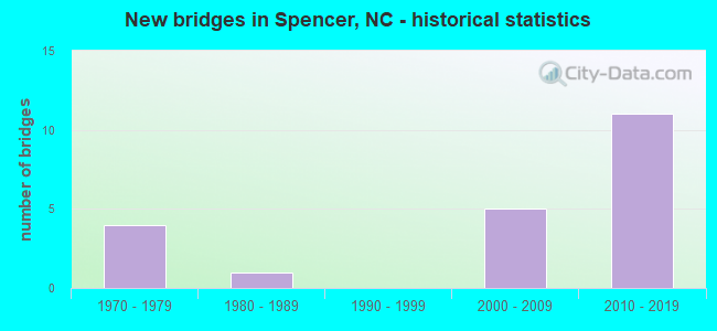
- New bridges - historical statistics
- 41970-1979
- 11980-1989
- 52000-2009
- 112010-2019


- Bridge Condition - Deck
- 8.3%Very good
- 66.7%Good
- 8.3%Satisfactory
- 16.7%Fair

- Bridge Condition - Superstructure
- 16.7%Very good
- 58.3%Good
- 16.7%Satisfactory
- 8.3%Fair

- Bridge Condition - Substructure
- 8.3%Very good
- 58.3%Good
- 8.3%Satisfactory
- 25.0%Fair

- Bridge Condition - Channel
- 66.7%Good
- 33.3%Fair
Find on map >> Show street view
Structure Number: 570013, Location: 0.1 MI. S. JCT. SR1140 (Lat: 35.730556, Lng: -80.407039), Route carried "on" structure: State highway 1139, Year Built: 1978, Status: Open, Structure Length: 0.85m (2.79ft), Average Daily Traffic: 520 (year 2017), Truck Traffic: 6%, Average Future Daily Traffic: 1,040 (year 2040), Design Load: HS 20+Mod, Features Intersected: ELLIS CREEK
Minimum Vertical Clearance: 30+ m (98+ ft), Kilometerpoint: 0.000, Lanes on structure: 2, Owner: State Highway Agency, Approaching Roadway Width: 4.8m (15.7ft), Material/Design: Steel, Design/Construction: Culvert, Number Of Spans In Main Unit: 3, Length of Maximum Span: 2.1m (6.9ft)
Condition: Channel: Good, Culverts: Satisfactory, Operating Rating: 89.8 metric tons, Method Used To Determine Operating Rating: Load and Resistance Factor (LRFR), Inventory Rating: 80.7 metric tons, Method Used To Determine Inventory Rating: Load and Resistance Factor (LRFR), Structural Evaluation: Equal to present minimum criteria, Waterway Adequacy: Better than present minimum criteria, Approach Roadway Alignment: Equal to present desirable criteria, Designated Inspection Frequency: Every 24 months, Underwater Inspection Frequency: Every 60 months, Inspection Date: January 2021, Underwater Inspection Date: January 2021
Find on map >> Show street view
Structure Number: 57002, Location: 0.3 MI. S. JCT. SR1147 (Lat: 35.731969, Lng: -80.375872), Route carried "on" structure: State highway 150, Year Built: 2013, Status: Open, Structure Length: 7.68m (25.20ft), Average Daily Traffic: 5,300 (year 2018), Truck Traffic: 6%, Average Future Daily Traffic: 10,600 (year 2040), Design Load: HL 93, Features Intersected: I85&US29,US52,US70
Minimum Vertical Clearance: 30+ m (98+ ft), Kilometerpoint: 0.000, Lanes on structure: 4, Lanes under structure: 10, Owner: State Highway Agency, Approaching Roadway Width: 23.4m (76.8ft), Skew: 21 degrees, Material/Design: Prestressed concrete continuous, Design/Construction: Stringer/Multi-beam, Number Of Spans In Main Unit: 2, Number Of Approach Spans: 2, Length of Maximum Span: 38.1m (125.0ft), Curb-To-Curb Width: 23.1m (75.8ft), Out-to-Out Width: 24.1m (79.1ft)
Condition: Deck: Good, Superstructure: Good, Substructure: Good, Operating Rating: 83.4 metric tons, Method Used To Determine Operating Rating: Load and Resistance Factor (LRFR), Inventory Rating: 48.0 metric tons, Method Used To Determine Inventory Rating: Load and Resistance Factor (LRFR), Structural Evaluation: Better than present minimum criteria, Deck Geometry: Superior to present desirable criteria, Underclear: Equal to present minimum criteria, Approach Roadway Alignment: Equal to present desirable criteria, Designated Inspection Frequency: Every 24 months, Inspection Date: July 2021, Deck Structure Type: Concrete Cast-file-Place, Wearing Surface/Protective System: Wearing Surface: Monolithic Concrete, Deck Protection: Epoxy Coated Reinforcing
Find on map >> Show street view
Structure Number: 159003, Location: 0.1 MI. E. JCT. SR1975 (Lat: 35.746739, Lng: -80.721961), Route carried "on" structure: State highway 1973, Year Built: 2000, Status: Open, Structure Length: 4.87m (15.98ft), Average Daily Traffic: 1,100 (year 2018), Truck Traffic: 6%, Average Future Daily Traffic: 2,200 (year 2040), Design Load: HS 20+Mod, Features Intersected: SOUTHERN RR
Minimum Vertical Clearance: 30+ m (98+ ft), Kilometerpoint: 0.000, Lanes on structure: 2, Owner: State Highway Agency, Approaching Roadway Width: 8.5m (27.9ft), Material/Design: Prestressed concrete continuous, Design/Construction: Stringer/Multi-beam, Number Of Spans In Main Unit: 3, Length of Maximum Span: 19.5m (64.0ft), Curb-To-Curb Width: 8.5m (27.9ft), Out-to-Out Width: 9.4m (30.8ft)
Condition: Deck: Good, Superstructure: Good, Substructure: Good, Operating Rating: 62.5 metric tons, Method Used To Determine Operating Rating: Load Factor (LF), Inventory Rating: 35.3 metric tons, Method Used To Determine Inventory Rating: Load Factor (LF), Structural Evaluation: Better than present minimum criteria, Deck Geometry: Somewhat better than minimum adequacy, Approach Roadway Alignment: Equal to present desirable criteria, Designated Inspection Frequency: Every 24 months, Inspection Date: Febuary 2022, Deck Structure Type: Concrete Cast-file-Place, Wearing Surface/Protective System: Wearing Surface: Monolithic Concrete, Deck Protection: Epoxy Coated Reinforcing
Find on map >> Show street view
Structure Number: 1590034, Location: 0.2MI.S. SR2740(N MA.ST.) (Lat: 35.566781, Lng: -80.550244), Route carried "on" structure: US 29, Year Built: 2018, Status: Open, Structure Length: 4.35m (14.27ft), Average Daily Traffic: 13,000 (year 2016), Truck Traffic: 12%, Average Future Daily Traffic: 26,000 (year 2040), Design Load: HS 15, Features Intersected: US29 LOOP/US29 RAMP
Minimum Vertical Clearance: 30+ m (98+ ft), Kilometerpoint: 0.000, Lanes on structure: 4, Lanes under structure: 4, Base Highway Network: Yes (Inventory Route: 2, Subroute: 29), Owner: State Highway Agency, Approaching Roadway Width: 21.6m (70.9ft), Material/Design: Prestressed concrete, Design/Construction: Stringer/Multi-beam, Number Of Spans In Main Unit: 1, Length of Maximum Span: 42.3m (138.8ft), Curb-To-Curb Width: 24.8m (81.4ft), Out-to-Out Width: 25.8m (84.6ft)
Condition: Deck: Very good, Superstructure: Very good, Substructure: Very good, Operating Rating: 78.9 metric tons, Method Used To Determine Operating Rating: Load Factor (LF), Inventory Rating: 49.8 metric tons, Method Used To Determine Inventory Rating: Load and Resistance Factor (LRFR), Structural Evaluation: Equal to present desirable criteria, Deck Geometry: Superior to present desirable criteria, Underclear: High priority of corrective action, Approach Roadway Alignment: Equal to present desirable criteria, Designated Inspection Frequency: Every 24 months, Inspection Date: January 2021, Deck Structure Type: Concrete Cast-file-Place, Wearing Surface/Protective System: Wearing Surface: Monolithic Concrete, Deck Protection: Epoxy Coated Reinforcing
Find on map >> Show street view
Structure Number: 1590086, Location: 0.9 MI. W. JCT. US29,70 (Lat: 35.697750, Lng: -80.446433), Route carried "on" structure: State highway 1912, Year Built: 1978, Status: Open, Structure Length: 3.65m (11.98ft), Average Daily Traffic: 830 (year 2016), Truck Traffic: 7%, Average Future Daily Traffic: 1,660 (year 2040), Design Load: HS 15, Features Intersected: GRANT'S CREEK
Minimum Vertical Clearance: 30+ m (98+ ft), Kilometerpoint: 0.000, Lanes on structure: 2, Owner: State Highway Agency, Approaching Roadway Width: 7.6m (24.9ft), Material/Design: Prestressed concrete, Design/Construction: Slab, Number Of Spans In Main Unit: 3, Length of Maximum Span: 11.8m (38.7ft), Curb-To-Curb Width: 8.7m (28.5ft), Out-to-Out Width: 9.2m (30.2ft)
Condition: Deck: Good, Superstructure: Good, Substructure: Fair, Channel: Fair, Operating Rating: 47.1 metric tons, Method Used To Determine Operating Rating: Load Factor (LF), Inventory Rating: 28.1 metric tons, Method Used To Determine Inventory Rating: Load Factor (LF), Structural Evaluation: Somewhat better than minimum adequacy, Deck Geometry: Somewhat better than minimum adequacy, Waterway Adequacy: Better than present minimum criteria, Approach Roadway Alignment: Equal to present desirable criteria, Designated Inspection Frequency: Every 24 months, Inspection Date: March 2021, Deck Structure Type: Concrete Precast Panels, Wearing Surface/Protective System: Wearing Surface: Bituminous
Find on map >> Show street view
Structure Number: 1590088, Location: 0.1 MI. S. JCT. SR1920 (Lat: 35.707250, Lng: -80.436275), Route carried "on" structure: State highway 1915, Year Built: 1974, Status: Open, Structure Length: 3.65m (11.98ft), Average Daily Traffic: 2,200 (year 2016), Truck Traffic: 7%, Average Future Daily Traffic: 4,400 (year 2040), Design Load: HS 15, Features Intersected: GRANTS CREEK
Minimum Vertical Clearance: 30+ m (98+ ft), Kilometerpoint: 0.000, Lanes on structure: 2, Owner: State Highway Agency, Approaching Roadway Width: 7.9m (25.9ft), Skew: 3 degrees, Material/Design: Prestressed concrete, Design/Construction: Slab, Number Of Spans In Main Unit: 3, Length of Maximum Span: 11.8m (38.7ft), Curb-To-Curb Width: 8.9m (29.2ft), Out-to-Out Width: 9.2m (30.2ft)
Condition: Deck: Fair, Superstructure: Fair, Substructure: Fair, Channel: Good, Operating Rating: 45.3 metric tons, Method Used To Determine Operating Rating: Load Factor (LF), Inventory Rating: 27.2 metric tons, Method Used To Determine Inventory Rating: Load Factor (LF), Structural Evaluation: Somewhat better than minimum adequacy, Deck Geometry: Meets minimum limits, Waterway Adequacy: Somewhat better than minimum adequacy, Approach Roadway Alignment: Equal to present desirable criteria, Designated Inspection Frequency: Every 24 months, Underwater Inspection Frequency: Every 60 months, Inspection Date: Febuary 2022, Underwater Inspection Date: Febuary 2019, Deck Structure Type: Concrete Precast Panels, Wearing Surface/Protective System: Wearing Surface: Bituminous
Find on map >> Show street view
Structure Number: 159013, Location: 0.3 MI. W. JCT. SR2337 (Lat: 35.519531, Lng: -80.408211), Route carried "on" structure: State highway 1221, Year Built: 2001, Status: Open, Structure Length: 0.88m (2.89ft), Average Daily Traffic: 2,000 (year 2012), Truck Traffic: 6%, Average Future Daily Traffic: 4,000 (year 2040), Design Load: HS 20+Mod, Features Intersected: KLUNS CREEK
Minimum Vertical Clearance: 30+ m (98+ ft), Kilometerpoint: 0.000, Lanes on structure: 2, Owner: State Highway Agency, Approaching Roadway Width: 6.4m (21.0ft), Material/Design: Steel, Design/Construction: Culvert, Number Of Spans In Main Unit: 2, Length of Maximum Span: 3.6m (11.8ft)
Condition: Channel: Fair, Culverts: Satisfactory, Operating Rating: 89.8 metric tons, Method Used To Determine Operating Rating: Load and Resistance Factor (LRFR), Inventory Rating: 89.8 metric tons, Method Used To Determine Inventory Rating: Load and Resistance Factor (LRFR), Structural Evaluation: Equal to present minimum criteria, Waterway Adequacy: Better than present minimum criteria, Approach Roadway Alignment: Equal to present desirable criteria, Designated Inspection Frequency: Every 24 months, Inspection Date: November 2020
Find on map >> Show street view
Structure Number: 1590134, Location: 0.45 MI. E. JCT. SR1915 (Lat: 35.695453, Lng: -80.400900), Route carried "on" structure: State highway 2120, Year Built: 2006, Status: Open, Structure Length: 6.15m (20.18ft), Average Daily Traffic: 6,400 (year 2019), Truck Traffic: 7%, Average Future Daily Traffic: 12,800 (year 2040), Design Load: HS 20+Mod, Features Intersected: I85
Minimum Vertical Clearance: 30+ m (98+ ft), Kilometerpoint: 0.000, Lanes on structure: 2, Lanes under structure: 8, Owner: State Highway Agency, Approaching Roadway Width: 15.8m (51.8ft), Material/Design: Prestressed concrete, Design/Construction: Stringer/Multi-beam, Number Of Spans In Main Unit: 2, Length of Maximum Span: 29.8m (97.8ft), Curb-To-Curb Width: 14.7m (48.2ft), Out-to-Out Width: 15.6m (51.2ft)
Condition: Deck: Good, Superstructure: Very good, Substructure: Good, Operating Rating: 89.8 metric tons, Method Used To Determine Operating Rating: Load Factor (LF), Inventory Rating: 27.2 metric tons, Method Used To Determine Inventory Rating: Load Factor (LF), Structural Evaluation: Equal to present minimum criteria, Deck Geometry: Superior to present desirable criteria, Underclear: Equal to present minimum criteria, Approach Roadway Alignment: Equal to present desirable criteria, Designated Inspection Frequency: Every 24 months, Inspection Date: March 2021, Deck Structure Type: Concrete Cast-file-Place, Wearing Surface/Protective System: Wearing Surface: Monolithic Concrete
Find on map >> Show street view
Structure Number: 1590135, Location: 1.0 MI. N. JCT. SR2120 (Lat: 35.709086, Lng: -80.396233), Route carried "on" structure: Interstate 85, Year Built: 2012, Status: Open, Structure Length: 4.41m (14.47ft), Average Daily Traffic: 36,000 (year 2015), Truck Traffic: 16%, Average Future Daily Traffic: 72,000 (year 2040), Design Load: HL 93, Features Intersected: DUKE POWER RR
Minimum Vertical Clearance: 30+ m (98+ ft), Kilometerpoint: 24.811, Lanes on structure: 4, Base Highway Network: Yes (Inventory Route: 1, Subroute: 85), Owner: State Highway Agency, Approaching Roadway Width: 21.6m (70.9ft), Skew: 13 degrees, Material/Design: Prestressed concrete, Design/Construction: Stringer/Multi-beam, Number Of Spans In Main Unit: 1, Length of Maximum Span: 42.6m (139.8ft), Curb-To-Curb Width: 22.1m (72.5ft), Out-to-Out Width: 23.1m (75.8ft)
Condition: Deck: Good, Superstructure: Good, Substructure: Good, Operating Rating: 80.7 metric tons, Method Used To Determine Operating Rating: Load and Resistance Factor (LRFR), Inventory Rating: 54.4 metric tons, Method Used To Determine Inventory Rating: Load and Resistance Factor (LRFR), Structural Evaluation: Better than present minimum criteria, Deck Geometry: Equal to present desirable criteria, Underclear: Better than present minimum criteria, Approach Roadway Alignment: Equal to present desirable criteria, Designated Inspection Frequency: Every 24 months, Inspection Date: April 2021, Deck Structure Type: Concrete Cast-file-Place, Wearing Surface/Protective System: Wearing Surface: Monolithic Concrete
Find on map >> Show street view
Structure Number: 1590136, Location: 1.0 MI. N. JCT. SR2120 (Lat: 35.709022, Lng: -80.396497), Route carried "on" structure: Interstate 85, Year Built: 2013, Status: Open, Structure Length: 4.38m (14.37ft), Average Daily Traffic: 36,000 (year 2015), Truck Traffic: 16%, Average Future Daily Traffic: 72,000 (year 2040), Design Load: HL 93, Features Intersected: DUKE POWER RR
Minimum Vertical Clearance: 30+ m (98+ ft), Kilometerpoint: 24.811, Lanes on structure: 4, Base Highway Network: Yes (Inventory Route: 1, Subroute: 85), Owner: State Highway Agency, Approaching Roadway Width: 22.2m (72.8ft), Skew: 13 degrees, Material/Design: Prestressed concrete, Design/Construction: Stringer/Multi-beam, Number Of Spans In Main Unit: 1, Length of Maximum Span: 42.3m (138.8ft), Curb-To-Curb Width: 22.1m (72.5ft), Out-to-Out Width: 23.1m (75.8ft)
Condition: Deck: Good, Superstructure: Good, Substructure: Good, Operating Rating: 80.7 metric tons, Method Used To Determine Operating Rating: Load and Resistance Factor (LRFR), Inventory Rating: 54.4 metric tons, Method Used To Determine Inventory Rating: Load and Resistance Factor (LRFR), Structural Evaluation: Better than present minimum criteria, Deck Geometry: Equal to present desirable criteria, Underclear: Better than present minimum criteria, Approach Roadway Alignment: Equal to present desirable criteria, Designated Inspection Frequency: Every 24 months, Inspection Date: April 2021, Deck Structure Type: Concrete Cast-file-Place, Wearing Surface/Protective System: Wearing Surface: Monolithic Concrete
Find on map >> Show street view
Structure Number: 1590137, Location: 1.0 MI. S. JCT. NC150 (Lat: 35.720653, Lng: -80.390658), Route carried "on" structure: Interstate 85, Year Built: 2013, Status: Open, Structure Length: 87.26m (286.29ft), Average Daily Traffic: 41,750 (year 2019), Truck Traffic: 16%, Average Future Daily Traffic: 83,500 (year 2040), Design Load: HL 93, Features Intersected: YADKIN RIVER & NSRR
Minimum Vertical Clearance: 30+ m (98+ ft), Kilometerpoint: 25.054, Lanes on structure: 4, Base Highway Network: Yes (Inventory Route: 1, Subroute: 85), Owner: State Highway Agency, Approaching Roadway Width: 21.3m (69.9ft), Skew: 19 degrees, Material/Design: Prestressed concrete continuous, Design/Construction: Stringer/Multi-beam, Number Of Spans In Main Unit: 20, Number Of Approach Spans: 1, Length of Maximum Span: 73.1m (239.8ft), Curb-To-Curb Width: 21.8m (71.5ft), Out-to-Out Width: 22.9m (75.1ft)
Condition: Deck: Good, Superstructure: Good, Substructure: Good, Channel: Good, Operating Rating: 70.7 metric tons, Method Used To Determine Operating Rating: Load and Resistance Factor (LRFR), Inventory Rating: 49.8 metric tons, Method Used To Determine Inventory Rating: Load and Resistance Factor (LRFR), Structural Evaluation: Better than present minimum criteria, Deck Geometry: Better than present minimum criteria, Underclear: Superior to present desirable criteria, Waterway Adequacy: Better than present minimum criteria, Approach Roadway Alignment: Equal to present desirable criteria, Designated Inspection Frequency: Every 24 months, Underwater Inspection Frequency: Every 60 months, Inspection Date: June 2020, Underwater Inspection Date: September 2021, Deck Structure Type: Concrete Cast-file-Place, Wearing Surface/Protective System: Wearing Surface: Monolithic Concrete, Deck Protection: Epoxy Coated Reinforcing
Find on map >> Show street view
Structure Number: 1590361, Location: 0.6 MI. N. JCT. US70 (Lat: 35.732006, Lng: -80.681158), Route carried "on" structure: State highway 1847, Year Built: 1989, Status: Open, Structure Length: 4.63m (15.19ft), Average Daily Traffic: 3,000 (year 2019), Truck Traffic: 7%, Average Future Daily Traffic: 6,000 (year 2040), Design Load: HS 20+Mod, Features Intersected: SOUTHERN RR
Minimum Vertical Clearance: 30+ m (98+ ft), Kilometerpoint: 0.000, Lanes on structure: 2, Owner: State Highway Agency, Approaching Roadway Width: 9.4m (30.8ft), Skew: 3 degrees, Material/Design: Steel, Design/Construction: Stringer/Multi-beam, Number Of Spans In Main Unit: 3, Length of Maximum Span: 19.5m (64.0ft), Curb or Sidewalk Widths: Left: 0.0m, Right: 1.2m (3.9ft), Curb-To-Curb Width: 8.5m (27.9ft), Out-to-Out Width: 10.6m (34.8ft)
Condition: Deck: Satisfactory, Superstructure: Satisfactory, Substructure: Satisfactory, Operating Rating: 89.8 metric tons, Method Used To Determine Operating Rating: Load Factor (LF), Inventory Rating: 53.5 metric tons, Method Used To Determine Inventory Rating: Load Factor (LF), Structural Evaluation: Equal to present minimum criteria, Deck Geometry: Meets minimum limits, Underclear: Somewhat better than minimum adequacy, Approach Roadway Alignment: Equal to present desirable criteria, Designated Inspection Frequency: Every 24 months, Inspection Date: May 2021, Deck Structure Type: Concrete Cast-file-Place, Wearing Surface/Protective System: Wearing Surface: Monolithic Concrete, Deck Protection: Epoxy Coated Reinforcing
Find on map >> Show street view
Structure Number: 1590363, Location: 0.1 MI. N. JCT. SR2100 (Lat: 35.691103, Lng: -80.423892), Route carried "on" structure: State highway 1915, Year Built: 1973, Status: Open, Structure Length: 12.92m (42.39ft), Average Daily Traffic: 2,600 (year 2015), Truck Traffic: 7%, Average Future Daily Traffic: 5,200 (year 2040), Design Load: HS 20+Mod, Features Intersected: SOUTHERN RAILWAY
Minimum Vertical Clearance: 30+ m (98+ ft), Kilometerpoint: 0.000, Lanes on structure: 4, Owner: State Highway Agency, Approaching Roadway Width: 15.8m (51.8ft), Skew: 1 degrees, Material/Design: Steel continuous, Design/Construction: Stringer/Multi-beam, Number Of Spans In Main Unit: 2, Number Of Approach Spans: 3, Length of Maximum Span: 35.6m (116.8ft), Curb or Sidewalk Widths: Left: 1.5m (4.9ft), Right: 1.5m (4.9ft), Curb-To-Curb Width: 15.7m (51.5ft), Out-to-Out Width: 19.6m (64.3ft)
Condition: Deck: Fair, Superstructure: Satisfactory, Substructure: Fair, Operating Rating: 64.4 metric tons, Method Used To Determine Operating Rating: Load Factor (LF), Inventory Rating: 39.0 metric tons, Method Used To Determine Inventory Rating: Load Factor (LF), Structural Evaluation: Somewhat better than minimum adequacy, Deck Geometry: Meets minimum limits, Underclear: Somewhat better than minimum adequacy, Approach Roadway Alignment: Equal to present desirable criteria, Designated Inspection Frequency: Every 24 months, Inspection Date: July 2020, Deck Structure Type: Concrete Cast-file-Place, Wearing Surface/Protective System: Wearing Surface: Monolithic Concrete
Find on map >> Show street view
Structure Number: 1590465, Location: 1.0 MI. S. JCT. NC150 (Lat: 35.720083, Lng: -80.390131), Route carried "on" structure: Interstate 85, Year Built: 2012, Status: Open, Structure Length: 88.51m (290.39ft), Average Daily Traffic: 36,000 (year 2015), Truck Traffic: 16%, Average Future Daily Traffic: 72,000 (year 2040), Design Load: HL 93, Features Intersected: YADKIN RIVER, N.S.R.R.
Minimum Vertical Clearance: 30+ m (98+ ft), Kilometerpoint: 25.054, Lanes on structure: 4, Base Highway Network: Yes (Inventory Route: 1, Subroute: 85), Owner: State Highway Agency, Approaching Roadway Width: 21.3m (69.9ft), Skew: 29 degrees, Material/Design: Prestressed concrete continuous, Design/Construction: Stringer/Multi-beam, Number Of Spans In Main Unit: 20, Number Of Approach Spans: 1, Length of Maximum Span: 73.1m (239.8ft), Curb-To-Curb Width: 21.8m (71.5ft), Out-to-Out Width: 22.9m (75.1ft)
Condition: Deck: Good, Superstructure: Good, Substructure: Good, Channel: Good, Operating Rating: 70.7 metric tons, Method Used To Determine Operating Rating: Load and Resistance Factor (LRFR), Inventory Rating: 48.9 metric tons, Method Used To Determine Inventory Rating: Load and Resistance Factor (LRFR), Structural Evaluation: Better than present minimum criteria, Deck Geometry: Better than present minimum criteria, Underclear: Superior to present desirable criteria, Waterway Adequacy: Better than present minimum criteria, Approach Roadway Alignment: Equal to present desirable criteria, Designated Inspection Frequency: Every 24 months, Underwater Inspection Frequency: Every 60 months, Inspection Date: June 2020, Underwater Inspection Date: June 2021, Deck Structure Type: Concrete Cast-file-Place, Wearing Surface/Protective System: Wearing Surface: Monolithic Concrete, Deck Protection: Epoxy Coated Reinforcing
Find on map >> Show street view
Structure Number: 57002, Location: 0.3 MI. S. JCT. SR1147 (Lat: 35.731969, Lng: -80.375872), Route carried "under" structure: Interstate 85, Year Built: 2013, Structure Length: 0. m, Average Daily Traffic: 39,500 (year 2018), Truck Traffic: 16%, Features Intersected: NC150
Minimum Vertical Clearance: 5.39m (17.68ft), Kilometerpoint: 25.542, Lanes on structure: 4, Lanes under structure: 5, Material/Design: Prestressed concrete continuous, Design/Construction: Stringer/Multi-beam, Length of Maximum Span: 38.1m (125.0ft)
Find on map >> Show street view
Structure Number: 57002, Location: 0.3 MI. S. JCT. SR1147 (Lat: 35.731969, Lng: -80.375872), Route carried "under" structure: Interstate 85, Year Built: 2013, Structure Length: 0. m, Average Daily Traffic: 39,500 (year 2018), Truck Traffic: 16%, Features Intersected: NC150
Minimum Vertical Clearance: 5.85m (19.19ft), Kilometerpoint: 25.542, Lanes on structure: 4, Lanes under structure: 5, Material/Design: Prestressed concrete continuous, Design/Construction: Stringer/Multi-beam, Length of Maximum Span: 38.1m (125.0ft)
Find on map >> Show street view
Structure Number: 1590034, Location: 0.2MI.S. SR2740(N MA.ST.) (Lat: 35.566781, Lng: -80.550244), Route carried "under" structure: US 29, Year Built: 2018, Structure Length: 0. m, Average Daily Traffic: 600 (year 2016), Truck Traffic: 12%, Features Intersected: US29/NC152
Minimum Vertical Clearance: 5.46m (17.91ft), Kilometerpoint: 0.000, Lanes on structure: 4, Lanes under structure: 1, Material/Design: Prestressed concrete, Design/Construction: Stringer/Multi-beam, Length of Maximum Span: 42.3m (138.8ft)
Find on map >> Show street view
Structure Number: 1590034, Location: 0.2MI.S. SR2740(N MA.ST.) (Lat: 35.566781, Lng: -80.550244), Route carried "under" structure: US 29, Year Built: 2018, Structure Length: 0. m, Average Daily Traffic: 6,000 (year 2016), Truck Traffic: 12%, Features Intersected: US29/NC152
Minimum Vertical Clearance: 4.90m (16.08ft), Kilometerpoint: 0.000, Lanes on structure: 4, Lanes under structure: 1, Material/Design: Prestressed concrete, Design/Construction: Stringer/Multi-beam, Length of Maximum Span: 42.3m (138.8ft)
Find on map >> Show street view
Structure Number: 1590034, Location: 0.2MI.S. SR2740(N MA.ST.) (Lat: 35.566781, Lng: -80.550244), Route carried "under" structure: US 29, Year Built: 2018, Structure Length: 0. m, Average Daily Traffic: 6,000 (year 2016), Truck Traffic: 12%, Features Intersected: US29/NC152
Minimum Vertical Clearance: 5.91m (19.39ft), Kilometerpoint: 0.000, Lanes on structure: 4, Lanes under structure: 2, Material/Design: Prestressed concrete, Design/Construction: Stringer/Multi-beam, Length of Maximum Span: 42.3m (138.8ft)
Find on map >> Show street view
Structure Number: 1590134, Location: 0.45 MI. E. JCT. SR1915 (Lat: 35.695453, Lng: -80.400900), Route carried "under" structure: Interstate 85, Year Built: 2006, Structure Length: 0. m, Average Daily Traffic: 40,500 (year 2017), Truck Traffic: 16%, Features Intersected: SR2120
Minimum Vertical Clearance: 5.82m (19.09ft), Kilometerpoint: 24.871, Lanes on structure: 2, Lanes under structure: 4, Material/Design: Prestressed concrete, Design/Construction: Stringer/Multi-beam, Length of Maximum Span: 29.8m (97.8ft)
Find on map >> Show street view
Structure Number: 1590134, Location: 0.45 MI. E. JCT. SR1915 (Lat: 35.695453, Lng: -80.400900), Route carried "under" structure: Interstate 85, Year Built: 2006, Structure Length: 0. m, Average Daily Traffic: 40,500 (year 2017), Truck Traffic: 16%, Features Intersected: SR2120
Minimum Vertical Clearance: 5.54m (18.18ft), Kilometerpoint: 24.871, Lanes on structure: 2, Lanes under structure: 4, Material/Design: Prestressed concrete, Design/Construction: Stringer/Multi-beam, Length of Maximum Span: 29.8m (97.8ft)