Bridge Statistics for Spokane Valley, Washington (WA)
Condition, Traffic, Stress, Structural Evaluation, Project Costs
- National Bridge Inventory (NBI) Statistics
- 32Number of bridges
- 394ft / 120mTotal length
- $94,056,000Total costs
- 927,927Total average daily traffic
- 65,514Total average daily truck traffic
- National Bridge Inventory (NBI) Registered Bridges for Spokane Valley
- No street view available for this location
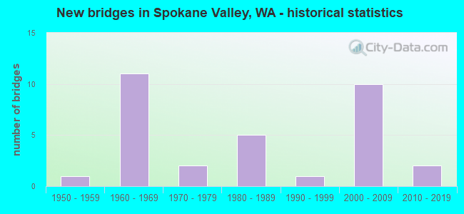
- New bridges - historical statistics
- 11950-1959
- 111960-1969
- 21970-1979
- 51980-1989
- 11990-1999
- 102000-2009
- 22010-2019
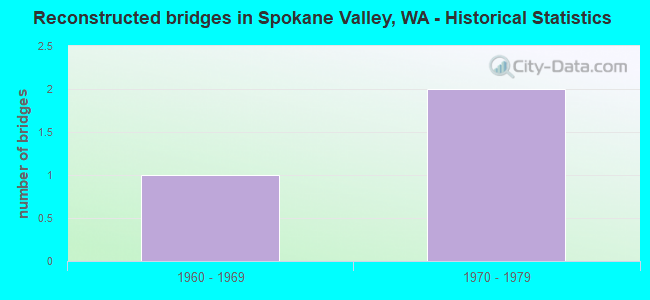
- Reconstructed bridges - Historical Statistics
- 11960-1969
- 21970-1979

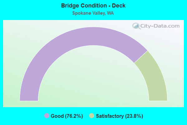
- Bridge Condition - Deck
- 76.2%Good
- 23.8%Satisfactory
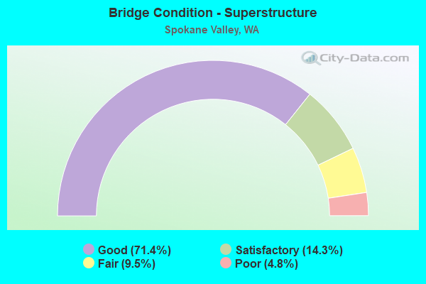
- Bridge Condition - Superstructure
- 71.4%Good
- 14.3%Satisfactory
- 9.5%Fair
- 4.8%Poor
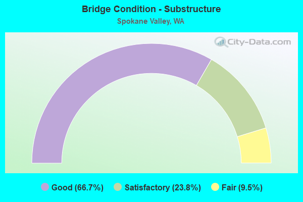
- Bridge Condition - Substructure
- 66.7%Good
- 23.8%Satisfactory
- 9.5%Fair
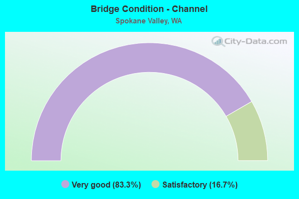
- Bridge Condition - Channel
- 83.3%Very good
- 16.7%Satisfactory
Find on map >> Show street view
Structure Number: NQ, Location: 10.5 E JCT US 2 (Lat: 47.695569, Lng: -117.196900), Route carried "on" structure: City street 8017, Year Built: 1960, Year Reconstructed: 1972, Status: Open, Structure Length: 2.44m (8.01ft), Average Daily Traffic: 21,200 (year 2018), Truck Traffic: 5%, Average Future Daily Traffic: 25,900 (year 2038), Design Load: HS 20, Features Intersected: SR 290 (TRENT AVE), Facility Carried by Structure: SULLIVAN RD
Minimum Vertical Clearance: 30+ m (98+ ft), Kilometerpoint: 7.162, Lanes on structure: 4, Lanes under structure: 4, Base Highway Network: Yes, Owner: City or Municipal Highway Agency, Approaching Roadway Width: 15.2m (49.9ft), Material/Design: Prestressed concrete, Design/Construction: Stringer/Multi-beam, Number Of Spans In Main Unit: 2, Length of Maximum Span: 12.2m (40.0ft), Curb or Sidewalk Widths: Left: 1.5m (4.9ft), Right: 1.5m (4.9ft), Curb-To-Curb Width: 15.2m (49.9ft), Out-to-Out Width: 18.9m (62.0ft)
Condition: Deck: Good, Superstructure: Poor, Substructure: Fair, Operating Rating: 43.5 metric tons, Method Used To Determine Operating Rating: Load Factor (LF), Inventory Rating: 26.3 metric tons, Method Used To Determine Inventory Rating: Load Factor (LF), Structural Evaluation: Meets minimum limits, Deck Geometry: High priority of corrective action, Underclear: Meets minimum limits, Approach Roadway Alignment: Equal to present desirable criteria, Length Of Structure Improvement: 2.74m (8.99ft), Designated Inspection Frequency: Every 24 months, Inspection Date: October 2021, Bridge Improvement Cost: $2,650,000, Roadway Improvement Cost: $530,000, Total Project Cost: $5,301,000 ( Estimate for 2022), Deck Structure Type: Concrete Cast-file-Place, Wearing Surface/Protective System: Wearing Surface: Bituminous
Find on map >> Show street view
Structure Number: 7107A, Location: 12.1 E JCT OLD SR 290 SPU (Lat: 47.701250, Lng: -117.148000), Route carried "on" structure: County highway , Year Built: 1963, Year Reconstructed: 1977, Status: Open, Structure Length: 1.49m (4.89ft), Average Daily Traffic: 5,807 (year 2001), Truck Traffic: 12%, Average Future Daily Traffic: 8,856 (year 2036), Design Load: HS 20, Features Intersected: SR 290 WB, Facility Carried by Structure: E WELLESLEY AVE
Minimum Vertical Clearance: 30+ m (98+ ft), Kilometerpoint: 0.579, Lanes on structure: 2, Lanes under structure: 1, Owner: State Highway Agency, Approaching Roadway Width: 15.2m (49.9ft), Skew: 4 degrees, Material/Design: Concrete, Design/Construction: Slab, Number Of Spans In Main Unit: 1, Length of Maximum Span: 14.6m (47.9ft), Curb-To-Curb Width: 11.0m (36.1ft), Out-to-Out Width: 11.9m (39.0ft)
Condition: Deck: Good, Superstructure: Good, Substructure: Good, Operating Rating: 72.3 metric tons, Method Used To Determine Operating Rating: Load and Resistance Factor Rating (LRFR) rating reported by rating factor(RF) method using HL-93 loadings, Inventory Rating: 55.7 metric tons, Method Used To Determine Inventory Rating: Load and Resistance Factor Rating (LRFR) rating reported by rating factor(RF) method using HL-93 loadings, Structural Evaluation: Better than present minimum criteria, Deck Geometry: Meets minimum limits, Underclear: Meets minimum limits, Approach Roadway Alignment: Equal to present minimum criteria, Length Of Structure Improvement: 1.49m (4.89ft), Designated Inspection Frequency: Every 48 months, Inspection Date: June 2018, Bridge Improvement Cost: $510,000, Roadway Improvement Cost: $102,000, Total Project Cost: $1,019,000 ( Estimate for 2014), Deck Structure Type: Concrete Cast-file-Place, Wearing Surface/Protective System: Wearing Surface: Bituminous, Membrane: Preformed Fabric
Find on map >> Show street view
Structure Number: 7107B, Location: 0.1 E JCT SR 290 EB (Lat: 47.700917, Lng: -117.147028), Route carried "on" structure: County highway 290, Year Built: 1963, Status: Open, Structure Length: 2.71m (8.89ft), Average Daily Traffic: 5,807 (year 2001), Truck Traffic: 12%, Average Future Daily Traffic: 8,856 (year 2036), Design Load: HS 20+Mod, Features Intersected: RAILROAD, Facility Carried by Structure: E WELLESLEY AVE
Minimum Vertical Clearance: 30+ m (98+ ft), Kilometerpoint: 0.644, Lanes on structure: 2, Owner: State Highway Agency, Approaching Roadway Width: 11.0m (36.1ft), Skew: 4 degrees, Material/Design: Concrete, Design/Construction: Tee Beam, Number Of Spans In Main Unit: 1, Length of Maximum Span: 12.2m (40.0ft), Curb-To-Curb Width: 11.0m (36.1ft), Out-to-Out Width: 12.1m (39.7ft)
Condition: Deck: Good, Superstructure: Good, Substructure: Good, Operating Rating: 41.7 metric tons, Method Used To Determine Operating Rating: Load Factor (LF), Inventory Rating: 24.5 metric tons, Method Used To Determine Inventory Rating: Load Factor (LF), Structural Evaluation: Equal to present minimum criteria, Deck Geometry: Meets minimum limits, Underclear: Better than present minimum criteria, Approach Roadway Alignment: Equal to present desirable criteria, Length Of Structure Improvement: 2.71m (8.89ft), Designated Inspection Frequency: Every 24 months, Inspection Date: April 2021, Bridge Improvement Cost: $676,000, Roadway Improvement Cost: $135,000, Total Project Cost: $1,353,000 ( Estimate for 2014), Deck Structure Type: Concrete Cast-file-Place, Wearing Surface/Protective System: Wearing Surface: Bituminous
Find on map >> Show street view
Structure Number: 7438A, Location: 6.1 E JCT OLD SR 290 SP (Lat: 47.683083, Lng: -117.272361), Route carried "on" structure: State highway 290, Year Built: 1964, Status: Open, Structure Length: 5.33m (17.49ft), Average Daily Traffic: 10,266 (year 2019), Truck Traffic: 7%, Average Future Daily Traffic: 13,222 (year 2039), Design Load: HS 20, Features Intersected: RAILROAD
Minimum Vertical Clearance: 30+ m (98+ ft), Kilometerpoint: 11.008, Lanes on structure: 2, Base Highway Network: Yes, Owner: State Highway Agency, Approaching Roadway Width: 9.1m (29.9ft), Skew: 1 degrees, Material/Design: Concrete continuous, Design/Construction: Slab, Number Of Spans In Main Unit: 4, Length of Maximum Span: 14.9m (48.9ft), Curb-To-Curb Width: 8.5m (27.9ft), Out-to-Out Width: 9.9m (32.5ft)
Condition: Deck: Satisfactory, Superstructure: Satisfactory, Substructure: Satisfactory, Operating Rating: 38.2 metric tons, Method Used To Determine Operating Rating: Load and Resistance Factor Rating (LRFR) rating reported by rating factor(RF) method using HL-93 loadings, Inventory Rating: 29.5 metric tons, Method Used To Determine Inventory Rating: Load and Resistance Factor Rating (LRFR) rating reported by rating factor(RF) method using HL-93 loadings, Structural Evaluation: Equal to present minimum criteria, Deck Geometry: High priority of corrective action, Underclear: Meets minimum limits, Approach Roadway Alignment: Equal to present desirable criteria, Length Of Structure Improvement: 5.33m (17.49ft), Designated Inspection Frequency: Every 48 months, Inspection Date: April 2018, Bridge Improvement Cost: $1,120,000, Roadway Improvement Cost: $224,000, Total Project Cost: $2,240,000 ( Estimate for 2014), Deck Structure Type: Concrete Cast-file-Place, Wearing Surface/Protective System: Wearing Surface: Bituminous, Membrane: Preformed Fabric
Find on map >> Show street view
Structure Number: 7924A, Location: 10.6 N JCT SR 278 (Lat: 47.576528, Lng: -117.224806), Route carried "on" structure: State highway 27, Year Built: 1966, Status: Open, Structure Length: 4.57m (14.99ft), Average Daily Traffic: 4,882 (year 2019), Truck Traffic: 6%, Average Future Daily Traffic: 6,288 (year 2039), Design Load: HS 20, Features Intersected: UP RR
Minimum Vertical Clearance: 30+ m (98+ ft), Kilometerpoint: 128.056, Lanes on structure: 2, Owner: State Highway Agency, Approaching Roadway Width: 11.6m (38.1ft), Skew: 2 degrees, Material/Design: Prestressed concrete continuous, Design/Construction: Stringer/Multi-beam, Number Of Spans In Main Unit: 3, Length of Maximum Span: 15.2m (49.9ft), Curb or Sidewalk Widths: Left: 0.5m (1.6ft), Right: 0.5m (1.6ft), Curb-To-Curb Width: 8.5m (27.9ft), Out-to-Out Width: 10.0m (32.8ft)
Condition: Deck: Good, Superstructure: Good, Substructure: Good, Operating Rating: 68.0 metric tons, Method Used To Determine Operating Rating: Load Factor (LF), Inventory Rating: 39.9 metric tons, Method Used To Determine Inventory Rating: Load Factor (LF), Structural Evaluation: Better than present minimum criteria, Deck Geometry: Meets minimum limits, Underclear: Better than present minimum criteria, Approach Roadway Alignment: Equal to present desirable criteria, Length Of Structure Improvement: 4.57m (14.99ft), Designated Inspection Frequency: Every 48 months, Inspection Date: May 2019, Bridge Improvement Cost: $1,200,000, Roadway Improvement Cost: $240,000, Total Project Cost: $2,400,000 ( Estimate for 2014), Deck Structure Type: Concrete Cast-file-Place, Wearing Surface/Protective System: Wearing Surface: Bituminous, Membrane: Preformed Fabric
Find on map >> Show street view
Structure Number: 8135A, Location: 7.9 E JCT OLD SR 290 SP (Lat: 47.691222, Lng: -117.235583), Route carried "on" structure: State highway 290, Year Built: 1967, Status: Open, Structure Length: 14.33m (47.01ft), Average Daily Traffic: 11,044 (year 2019), Truck Traffic: 7%, Average Future Daily Traffic: 14,224 (year 2039), Design Load: HS 20+Mod, Features Intersected: SPOKANE RIVER
Minimum Vertical Clearance: 30+ m (98+ ft), Kilometerpoint: 13.921, Lanes on structure: 2, Base Highway Network: Yes, Owner: State Highway Agency, Approaching Roadway Width: 11.0m (36.1ft), Material/Design: Concrete continuous, Design/Construction: Box Beam or Girders - Multiple, Number Of Spans In Main Unit: 3, Number Of Approach Spans: 2, Length of Maximum Span: 48.8m (160.1ft), Curb or Sidewalk Widths: Left: 0.5m (1.6ft), Right: 0.5m (1.6ft), Curb-To-Curb Width: 9.1m (29.9ft), Out-to-Out Width: 11.0m (36.1ft)
Condition: Deck: Good, Superstructure: Good, Substructure: Good, Channel: Very good, Operating Rating: 46.3 metric tons, Method Used To Determine Operating Rating: Load Factor (LF), Inventory Rating: 28.1 metric tons, Method Used To Determine Inventory Rating: Load Factor (LF), Structural Evaluation: Better than present minimum criteria, Deck Geometry: Meets minimum limits, Waterway Adequacy: Equal to present desirable criteria, Approach Roadway Alignment: Equal to present desirable criteria, Length Of Structure Improvement: 14.33m (47.01ft), Designated Inspection Frequency: Every 24 months, Inspection Date: August 2021, Bridge Improvement Cost: $3,572,000, Roadway Improvement Cost: $714,000, Total Project Cost: $7,144,000 ( Estimate for 2014), Deck Structure Type: Concrete Cast-file-Place, Wearing Surface/Protective System: Wearing Surface: Bituminous, Membrane: Preformed Fabric
Find on map >> Show street view
Structure Number: 12818A, Location: 2.0 E JCT SR 27 (Lat: 47.668917, Lng: -117.196639), Route carried "on" structure: County highway , Year Built: 1985, Status: Open, Structure Length: 5.76m (18.90ft), Average Daily Traffic: 34,662 (year 2016), Truck Traffic: 5%, Average Future Daily Traffic: 47,474 (year 2038), Design Load: HS 20+Mod, Features Intersected: I-90, Facility Carried by Structure: SULLIVAN RD
Minimum Vertical Clearance: 30+ m (98+ ft), Kilometerpoint: 0.418, Lanes on structure: 6, Lanes under structure: 7, Base Highway Network: Yes, Owner: State Highway Agency, Approaching Roadway Width: 29.6m (97.1ft), Skew: 21 degrees, Material/Design: Prestressed concrete continuous, Design/Construction: Stringer/Multi-beam, Number Of Spans In Main Unit: 2, Length of Maximum Span: 30.8m (101.0ft), Curb or Sidewalk Widths: Left: 1.8m (5.9ft), Right: 1.8m (5.9ft), Curb-To-Curb Width: 29.6m (97.1ft), Out-to-Out Width: 34.6m (113.5ft)
Condition: Deck: Satisfactory, Superstructure: Satisfactory, Substructure: Good, Operating Rating: 64.4 metric tons, Method Used To Determine Operating Rating: Load Factor (LF), Inventory Rating: 38.1 metric tons, Method Used To Determine Inventory Rating: Load Factor (LF), Structural Evaluation: Equal to present minimum criteria, Deck Geometry: Superior to present desirable criteria, Underclear: Equal to present minimum criteria, Approach Roadway Alignment: Equal to present desirable criteria, Length Of Structure Improvement: 5.76m (18.90ft), Designated Inspection Frequency: Every 24 months, Inspection Date: October 2020, Bridge Improvement Cost: $3,742,000, Roadway Improvement Cost: $748,000, Total Project Cost: $7,484,000 ( Estimate for 2014), Deck Structure Type: Concrete Cast-file-Place, Wearing Surface/Protective System: Wearing Surface: Monolithic Concrete, Deck Protection: Epoxy Coated Reinforcing
Find on map >> Show street view
Structure Number: 13050A, Location: 4.9 E JCT US 2 (Lat: 47.663761, Lng: -117.313058), Route carried "on" structure: County highway , Year Built: 1986, Status: Open, Structure Length: 10.12m (33.20ft), Average Daily Traffic: 14,098 (year 2010), Truck Traffic: 5%, Average Future Daily Traffic: 20,696 (year 2036), Design Load: HS 20+Mod, Features Intersected: I-90, Facility Carried by Structure: E BROADWAY AVE
Minimum Vertical Clearance: 30+ m (98+ ft), Kilometerpoint: 0.080, Lanes on structure: 6, Lanes under structure: 5, Base Highway Network: Yes, Owner: State Highway Agency, Approaching Roadway Width: 24.7m (81.0ft), Skew: 5 degrees, Material/Design: Steel continuous, Design/Construction: Stringer/Multi-beam, Number Of Spans In Main Unit: 2, Length of Maximum Span: 52.7m (172.9ft), Curb or Sidewalk Widths: Left: 0.0m, Right: 1.5m (4.9ft), Curb-To-Curb Width: 24.7m (81.0ft), Out-to-Out Width: 27.1m (88.9ft)
Condition: Deck: Good, Superstructure: Good, Substructure: Satisfactory, Operating Rating: 44.4 metric tons, Method Used To Determine Operating Rating: Load Factor (LF), Inventory Rating: 27.2 metric tons, Method Used To Determine Inventory Rating: Load Factor (LF), Structural Evaluation: Equal to present minimum criteria, Deck Geometry: Somewhat better than minimum adequacy, Underclear: High priority of corrective action, Approach Roadway Alignment: Equal to present desirable criteria, Length Of Structure Improvement: 10.12m (33.20ft), Designated Inspection Frequency: Every 24 months, Inspection Date: October 2020, Bridge Improvement Cost: $5,511,000, Roadway Improvement Cost: $1,102,000, Total Project Cost: $11,022,000 ( Estimate for 2014), Deck Structure Type: Concrete Cast-file-Place, Wearing Surface/Protective System: Wearing Surface: Monolithic Concrete, Deck Protection: Epoxy Coated Reinforcing
Find on map >> Show street view
Structure Number: 13145A, Location: 7.9 E JCT OLD SR 290 SP (Lat: 47.691364, Lng: -117.235753), Route carried "on" structure: State highway 290, Year Built: 1987, Status: Open, Structure Length: 14.33m (47.01ft), Average Daily Traffic: 11,044 (year 2019), Truck Traffic: 7%, Average Future Daily Traffic: 14,224 (year 2039), Design Load: HS 20+Mod, Features Intersected: SPOKANE RIVER
Minimum Vertical Clearance: 30+ m (98+ ft), Kilometerpoint: 13.921, Lanes on structure: 2, Base Highway Network: Yes, Owner: State Highway Agency, Approaching Roadway Width: 9.8m (32.2ft), Material/Design: Prestressed concrete continuous, Design/Construction: Box Beam or Girders - Multiple, Number Of Spans In Main Unit: 3, Length of Maximum Span: 48.8m (160.1ft), Curb or Sidewalk Widths: Left: 2.4m (7.9ft), Right: 0.0m, Curb-To-Curb Width: 9.8m (32.2ft), Out-to-Out Width: 13.4m (44.0ft)
Condition: Deck: Good, Superstructure: Good, Substructure: Good, Channel: Very good, Operating Rating: 88.9 metric tons, Method Used To Determine Operating Rating: Load Factor (LF), Inventory Rating: 52.6 metric tons, Method Used To Determine Inventory Rating: Load Factor (LF), Structural Evaluation: Better than present minimum criteria, Deck Geometry: Meets minimum limits, Waterway Adequacy: Equal to present desirable criteria, Approach Roadway Alignment: Equal to present desirable criteria, Length Of Structure Improvement: 14.33m (47.01ft), Designated Inspection Frequency: Every 24 months, Inspection Date: August 2021, Bridge Improvement Cost: $3,196,000, Roadway Improvement Cost: $639,000, Total Project Cost: $6,392,000 ( Estimate for 2014), Deck Structure Type: Concrete Cast-file-Place, Wearing Surface/Protective System: Wearing Surface: Monolithic Concrete, Deck Protection: Epoxy Coated Reinforcing
Find on map >> Show street view
Structure Number: 15438A, Location: 4.3 E JCT US 2 (Lat: 47.656722, Lng: -117.321917), Route carried "on" structure: Interstate 90, Year Built: 2000, Status: Open, Structure Length: 6.71m (22.01ft), Average Daily Traffic: 52,765 (year 2019), Truck Traffic: 7%, Average Future Daily Traffic: 67,961 (year 2039), Design Load: HS 25 or greater, Features Intersected: SPRAGUE AVE
Minimum Vertical Clearance: 30+ m (98+ ft), Kilometerpoint: 459.645, Lanes on structure: 4, Lanes under structure: 6, Base Highway Network: Yes, Owner: State Highway Agency, Approaching Roadway Width: 20.7m (67.9ft), Skew: 3 degrees, Material/Design: Prestressed concrete continuous, Design/Construction: Stringer/Multi-beam, Number Of Spans In Main Unit: 2, Length of Maximum Span: 40.2m (131.9ft), Curb-To-Curb Width: 20.7m (67.9ft), Out-to-Out Width: 21.6m (70.9ft)
Condition: Deck: Good, Superstructure: Good, Substructure: Good, Operating Rating: 73.5 metric tons, Method Used To Determine Operating Rating: Load Factor (LF), Inventory Rating: 44.4 metric tons, Method Used To Determine Inventory Rating: Load Factor (LF), Structural Evaluation: Better than present minimum criteria, Deck Geometry: Equal to present minimum criteria, Underclear: Equal to present minimum criteria, Approach Roadway Alignment: Equal to present desirable criteria, Length Of Structure Improvement: 6.71m (22.01ft), Designated Inspection Frequency: Every 48 months, Inspection Date: October 2018, Bridge Improvement Cost: $3,080,000, Roadway Improvement Cost: $616,000, Total Project Cost: $6,160,000 ( Estimate for 2014), Deck Structure Type: Concrete Cast-file-Place, Wearing Surface/Protective System: Wearing Surface: Monolithic Concrete, Deck Protection: Epoxy Coated Reinforcing
Find on map >> Show street view
Structure Number: 15438B, Location: 4.4 E JCT US 2 (Lat: 47.658333, Lng: -117.320000), Route carried "on" structure: Interstate 90, Year Built: 2000, Status: Open, Structure Length: 1.80m (5.91ft), Average Daily Traffic: 52,765 (year 2019), Truck Traffic: 7%, Average Future Daily Traffic: 67,961 (year 2039), Design Load: HS 25 or greater, Features Intersected: UPRR
Minimum Vertical Clearance: 30+ m (98+ ft), Kilometerpoint: 459.886, Lanes on structure: 4, Base Highway Network: Yes, Owner: State Highway Agency, Approaching Roadway Width: 20.7m (67.9ft), Material/Design: Concrete, Design/Construction: Frame, Number Of Spans In Main Unit: 1, Length of Maximum Span: 17.1m (56.1ft), Curb-To-Curb Width: 20.7m (67.9ft), Out-to-Out Width: 21.3m (69.9ft)
Condition: Deck: Good, Superstructure: Good, Substructure: Good, Operating Rating: 86.2 metric tons, Method Used To Determine Operating Rating: Load Factor (LF), Inventory Rating: 51.7 metric tons, Method Used To Determine Inventory Rating: Load Factor (LF), Structural Evaluation: Better than present minimum criteria, Deck Geometry: Equal to present minimum criteria, Underclear: Superior to present desirable criteria, Approach Roadway Alignment: Equal to present desirable criteria, Length Of Structure Improvement: 1.80m (5.91ft), Designated Inspection Frequency: Every 48 months, Inspection Date: October 2018, Bridge Improvement Cost: $826,000, Roadway Improvement Cost: $165,000, Total Project Cost: $1,652,000 ( Estimate for 2014), Deck Structure Type: Concrete Cast-file-Place, Wearing Surface/Protective System: Wearing Surface: Monolithic Concrete, Deck Protection: Epoxy Coated Reinforcing
Find on map >> Show street view
Structure Number: 15637A, Location: 5.4 E JCT US 2 (Lat: 47.667206, Lng: -117.304069), Route carried "on" structure: City street , Year Built: 2000, Status: Open, Structure Length: 6.95m (22.80ft), Average Daily Traffic: 6,503 (year 2002), Truck Traffic: 5%, Average Future Daily Traffic: 9,820 (year 2036), Design Load: HS 25 or greater, Features Intersected: I-90, Facility Carried by Structure: PARK ROAD
Minimum Vertical Clearance: 30+ m (98+ ft), Kilometerpoint: 2.945, Lanes on structure: 5, Lanes under structure: 8, Owner: State Highway Agency, Approaching Roadway Width: 21.9m (71.9ft), Skew: 3 degrees, Material/Design: Prestressed concrete continuous, Design/Construction: Stringer/Multi-beam, Number Of Spans In Main Unit: 2, Length of Maximum Span: 33.8m (110.9ft), Curb or Sidewalk Widths: Left: 2.0m (6.6ft), Right: 2.0m (6.6ft), Curb-To-Curb Width: 21.9m (71.9ft), Out-to-Out Width: 26.5m (86.9ft)
Condition: Deck: Good, Superstructure: Good, Substructure: Good, Operating Rating: 72.6 metric tons, Method Used To Determine Operating Rating: Load Factor (LF), Inventory Rating: 43.5 metric tons, Method Used To Determine Inventory Rating: Load Factor (LF), Structural Evaluation: Better than present minimum criteria, Deck Geometry: Somewhat better than minimum adequacy, Underclear: Equal to present minimum criteria, Approach Roadway Alignment: Equal to present desirable criteria, Length Of Structure Improvement: 6.95m (22.80ft), Designated Inspection Frequency: Every 48 months, Inspection Date: October 2018, Bridge Improvement Cost: $3,374,000, Roadway Improvement Cost: $675,000, Total Project Cost: $6,749,000 ( Estimate for 2014), Deck Structure Type: Concrete Cast-file-Place, Wearing Surface/Protective System: Wearing Surface: Monolithic Concrete, Deck Protection: Epoxy Coated Reinforcing
Find on map >> Show street view
Structure Number: 15947A, Location: 4.3 E JCT US 2 (Lat: 47.656983, Lng: -117.322000), Route carried "on" structure: Interstate 90, Year Built: 2001, Status: Open, Structure Length: 6.74m (22.11ft), Average Daily Traffic: 52,765 (year 2019), Truck Traffic: 7%, Average Future Daily Traffic: 67,961 (year 2039), Design Load: HS 25 or greater, Features Intersected: SPRAGUE AVE
Minimum Vertical Clearance: 30+ m (98+ ft), Kilometerpoint: 459.613, Lanes on structure: 4, Lanes under structure: 7, Base Highway Network: Yes, Owner: State Highway Agency, Approaching Roadway Width: 20.7m (67.9ft), Skew: 3 degrees, Material/Design: Prestressed concrete continuous, Design/Construction: Stringer/Multi-beam, Number Of Spans In Main Unit: 2, Length of Maximum Span: 40.2m (131.9ft), Curb-To-Curb Width: 20.7m (67.9ft), Out-to-Out Width: 21.3m (69.9ft)
Condition: Deck: Good, Superstructure: Good, Substructure: Good, Operating Rating: 85.3 metric tons, Method Used To Determine Operating Rating: Load Factor (LF), Inventory Rating: 50.8 metric tons, Method Used To Determine Inventory Rating: Load Factor (LF), Structural Evaluation: Better than present minimum criteria, Deck Geometry: Equal to present minimum criteria, Underclear: Equal to present minimum criteria, Approach Roadway Alignment: Equal to present desirable criteria, Length Of Structure Improvement: 6.74m (22.11ft), Designated Inspection Frequency: Every 48 months, Inspection Date: October 2018, Bridge Improvement Cost: $3,094,000, Roadway Improvement Cost: $619,000, Total Project Cost: $6,188,000 ( Estimate for 2014), Deck Structure Type: Concrete Cast-file-Place, Wearing Surface/Protective System: Wearing Surface: Monolithic Concrete, Deck Protection: Epoxy Coated Reinforcing
Find on map >> Show street view
Structure Number: 15947B, Location: 4.4 E JCT US 2 (Lat: 47.658833, Lng: -117.320033), Route carried "on" structure: Interstate 90, Year Built: 2001, Status: Open, Structure Length: 1.80m (5.91ft), Average Daily Traffic: 52,765 (year 2019), Truck Traffic: 7%, Average Future Daily Traffic: 67,961 (year 2039), Design Load: HS 25 or greater, Features Intersected: UPRR
Minimum Vertical Clearance: 30+ m (98+ ft), Kilometerpoint: 459.886, Lanes on structure: 4, Base Highway Network: Yes, Owner: State Highway Agency, Approaching Roadway Width: 20.7m (67.9ft), Material/Design: Concrete, Design/Construction: Frame, Number Of Spans In Main Unit: 1, Length of Maximum Span: 17.1m (56.1ft), Curb-To-Curb Width: 20.7m (67.9ft), Out-to-Out Width: 21.3m (69.9ft)
Condition: Deck: Good, Superstructure: Good, Substructure: Good, Operating Rating: 89.8 metric tons, Method Used To Determine Operating Rating: Load Factor (LF), Inventory Rating: 80.7 metric tons, Method Used To Determine Inventory Rating: Load Factor (LF), Structural Evaluation: Better than present minimum criteria, Deck Geometry: Equal to present minimum criteria, Underclear: Superior to present desirable criteria, Approach Roadway Alignment: Equal to present desirable criteria, Length Of Structure Improvement: 1.80m (5.91ft), Designated Inspection Frequency: Every 48 months, Inspection Date: October 2018, Bridge Improvement Cost: $826,000, Roadway Improvement Cost: $165,000, Total Project Cost: $1,652,000 ( Estimate for 2014), Deck Structure Type: Concrete Cast-file-Place, Wearing Surface/Protective System: Wearing Surface: Monolithic Concrete, Deck Protection: Epoxy Coated Reinforcing
Find on map >> Show street view
Structure Number: 15947C, Location: 4.3 E JCT US 2 (Lat: 47.655714, Lng: -117.325022), Route carried "on" structure: Ramp Interstate 90, Year Built: 2001, Status: Open, Structure Length: 2.16m (7.09ft), Average Daily Traffic: 9,213 (year 2019), Truck Traffic: 5%, Average Future Daily Traffic: 11,866 (year 2039), Design Load: HS 25 or greater, Features Intersected: W-N RAMP, Facility Carried by Structure: W-W RAMP
Minimum Vertical Clearance: 30+ m (98+ ft), Kilometerpoint: 0.435, Lanes on structure: 2, Lanes under structure: 1, Owner: State Highway Agency, Approaching Roadway Width: 14.9m (48.9ft), Material/Design: Prestressed concrete, Design/Construction: Stringer/Multi-beam, Number Of Spans In Main Unit: 1, Length of Maximum Span: 20.1m (65.9ft), Curb-To-Curb Width: 14.9m (48.9ft), Out-to-Out Width: 15.8m (51.8ft)
Condition: Deck: Good, Superstructure: Good, Substructure: Good, Operating Rating: 89.8 metric tons, Method Used To Determine Operating Rating: Load Factor (LF), Inventory Rating: 64.4 metric tons, Method Used To Determine Inventory Rating: Load Factor (LF), Structural Evaluation: Better than present minimum criteria, Deck Geometry: Superior to present desirable criteria, Underclear: Superior to present desirable criteria, Approach Roadway Alignment: Equal to present desirable criteria, Length Of Structure Improvement: 2.16m (7.09ft), Designated Inspection Frequency: Every 48 months, Inspection Date: October 2021, Bridge Improvement Cost: $724,000, Roadway Improvement Cost: $145,000, Total Project Cost: $1,448,000 ( Estimate for 2014), Deck Structure Type: Concrete Cast-file-Place, Wearing Surface/Protective System: Wearing Surface: Monolithic Concrete, Deck Protection: Epoxy Coated Reinforcing
Find on map >> Show street view
Structure Number: 79723, Location: 0.05 S TRENT RD (Lat: 47.695139, Lng: -117.196889), Route carried "on" structure: City street 8017, Year Built: 1960, Year Reconstructed: 1976, Status: Open, Structure Length: 1.43m (4.69ft), Average Daily Traffic: 21,200 (year 2018), Truck Traffic: 5%, Average Future Daily Traffic: 25,900 (year 2038), Design Load: HS 20, Features Intersected: BNSF RAILROAD, Facility Carried by Structure: SULLIVAN ROAD
Minimum Vertical Clearance: 30+ m (98+ ft), Kilometerpoint: 7.097, Lanes on structure: 4, Base Highway Network: Yes, Owner: City or Municipal Highway Agency, Approaching Roadway Width: 15.8m (51.8ft), Material/Design: Prestressed concrete, Design/Construction: Stringer/Multi-beam, Number Of Spans In Main Unit: 1, Length of Maximum Span: 14.0m (45.9ft), Curb or Sidewalk Widths: Left: 1.5m (4.9ft), Right: 1.5m (4.9ft), Curb-To-Curb Width: 15.2m (49.9ft), Out-to-Out Width: 19.0m (62.3ft)
Condition: Deck: Satisfactory, Superstructure: Fair, Substructure: Fair, Operating Rating: 51.7 metric tons, Method Used To Determine Operating Rating: Load Factor (LF), Inventory Rating: 27.2 metric tons, Method Used To Determine Inventory Rating: Load Factor (LF), Structural Evaluation: Somewhat better than minimum adequacy, Deck Geometry: High priority of corrective action, Underclear: Superior to present desirable criteria, Approach Roadway Alignment: Equal to present minimum criteria, Length Of Structure Improvement: 1.74m (5.71ft), Designated Inspection Frequency: Every 24 months, Inspection Date: October 2021, Bridge Improvement Cost: $1,414,000, Roadway Improvement Cost: $283,000, Total Project Cost: $2,827,000 ( Estimate for 2014), Deck Structure Type: Other, Wearing Surface/Protective System: Wearing Surface: Bituminous
Find on map >> Show street view
Structure Number: 81398, Location: 0.25 N I-90 (Lat: 47.672500, Lng: -117.196472), Route carried "on" structure: City street 4597, Year Built: 1973, Status: Open, Structure Length: 13.32m (43.70ft), Average Daily Traffic: 24,700 (year 2018), Truck Traffic: 13%, Average Future Daily Traffic: 30,100 (year 2038), Design Load: HS 20, Features Intersected: SPOKANE RIVER, Facility Carried by Structure: SULLIVAN ROAD (NB)
Minimum Vertical Clearance: 30+ m (98+ ft), Kilometerpoint: 6.486, Lanes on structure: 2, Base Highway Network: Yes, Owner: City or Municipal Highway Agency, Approaching Roadway Width: 11.0m (36.1ft), Skew: 3 degrees, Material/Design: Prestressed concrete continuous, Design/Construction: Stringer/Multi-beam, Number Of Spans In Main Unit: 4, Length of Maximum Span: 34.7m (113.8ft), Curb or Sidewalk Widths: Left: 0.0m, Right: 1.7m (5.6ft), Curb-To-Curb Width: 8.5m (27.9ft), Out-to-Out Width: 11.1m (36.4ft)
Condition: Deck: Satisfactory, Superstructure: Satisfactory, Substructure: Satisfactory, Channel: Very good, Operating Rating: 30.8 metric tons, Method Used To Determine Operating Rating: Load and Resistance Factor (LRFR), Inventory Rating: 24.5 metric tons, Method Used To Determine Inventory Rating: Load and Resistance Factor (LRFR), Structural Evaluation: Equal to present minimum criteria, Deck Geometry: High priority of corrective action, Waterway Adequacy: Equal to present desirable criteria, Approach Roadway Alignment: Equal to present desirable criteria, Length Of Structure Improvement: 13.62m (44.69ft), Designated Inspection Frequency: Every 24 months, Underwater Inspection Frequency: Every 60 months, Inspection Date: October 2021, Underwater Inspection Date: August 2020, Bridge Improvement Cost: $6,794,000, Roadway Improvement Cost: $1,359,000, Total Project Cost: $13,589,000 ( Estimate for 2014), Deck Structure Type: Concrete Cast-file-Place, Wearing Surface/Protective System: Wearing Surface: Latex Concrete
Find on map >> Show street view
Structure Number: 84441, Location: 0.2 S.CHESTER (Lat: 47.616717, Lng: -117.250547), Route carried "on" structure: City street 4418, Year Built: 1977, Status: Open, Structure Length: 0.76m (2.49ft), Average Daily Traffic: 2,200 (year 2018), Truck Traffic: 7%, Average Future Daily Traffic: 3,225 (year 2038), Design Load: HS 20, Features Intersected: CHESTER CREEK, Facility Carried by Structure: SANDS ROAD
Minimum Vertical Clearance: 30+ m (98+ ft), Kilometerpoint: 0.001, Lanes on structure: 2, Owner: City or Municipal Highway Agency, Approaching Roadway Width: 6.7m (22.0ft), Skew: 2 degrees, Material/Design: Prestressed concrete, Design/Construction: Stringer/Multi-beam, Number Of Spans In Main Unit: 1, Length of Maximum Span: 7.3m (24.0ft), Curb-To-Curb Width: 11.9m (39.0ft), Out-to-Out Width: 12.2m (40.0ft)
Condition: Deck: Satisfactory, Superstructure: Fair, Substructure: Satisfactory, Channel: Very good, Operating Rating: 42.6 metric tons, Method Used To Determine Operating Rating: Load Factor (LF), Inventory Rating: 25.4 metric tons, Method Used To Determine Inventory Rating: Load Factor (LF), Structural Evaluation: Somewhat better than minimum adequacy, Deck Geometry: Somewhat better than minimum adequacy, Waterway Adequacy: Equal to present minimum criteria, Approach Roadway Alignment: Equal to present minimum criteria, Length Of Structure Improvement: 0.76m (2.49ft), Designated Inspection Frequency: Every 24 months, Inspection Date: October 2021, Bridge Improvement Cost: $120,000, Roadway Improvement Cost: $24,000, Total Project Cost: $240,000 ( Estimate for 2014), Deck Structure Type: Other, Wearing Surface/Protective System: Wearing Surface: Epoxy Overlay
Find on map >> Show street view
Structure Number: 86465, Location: 0.1 S CHESTER (Lat: 47.614517, Lng: -117.244881), Route carried "on" structure: County highway 8007, Year Built: 1999, Status: Open, Structure Length: 1.01m (3.31ft), Average Daily Traffic: 5,300 (year 2018), Truck Traffic: 15%, Average Future Daily Traffic: 6,500 (year 2038), Design Load: HS 25 or greater, Features Intersected: CHESTER CREEK, Facility Carried by Structure: DISHMAN-MICA RD
Minimum Vertical Clearance: 30+ m (98+ ft), Kilometerpoint: 0.001, Lanes on structure: 2, Owner: City or Municipal Highway Agency, Approaching Roadway Width: 9.8m (32.2ft), Skew: 4 degrees, Material/Design: Prestressed concrete, Design/Construction: Stringer/Multi-beam, Number Of Spans In Main Unit: 2, Length of Maximum Span: 5.2m (17.1ft), Curb-To-Curb Width: 11.6m (38.1ft), Out-to-Out Width: 14.6m (47.9ft)
Condition: Deck: Good, Superstructure: Good, Substructure: Satisfactory, Channel: Satisfactory, Operating Rating: 89.8 metric tons, Method Used To Determine Operating Rating: Load Factor (LF), Inventory Rating: 59.9 metric tons, Method Used To Determine Inventory Rating: Load Factor (LF), Structural Evaluation: Equal to present minimum criteria, Deck Geometry: Somewhat better than minimum adequacy, Waterway Adequacy: Better than present minimum criteria, Approach Roadway Alignment: Equal to present desirable criteria, Length Of Structure Improvement: 1.01m (3.31ft), Designated Inspection Frequency: Every 24 months, Inspection Date: May 2020, Bridge Improvement Cost: $224,000, Roadway Improvement Cost: $45,000, Total Project Cost: $449,000 ( Estimate for 2014), Deck Structure Type: Concrete Precast Panels, Wearing Surface/Protective System: Wearing Surface: Bituminous, Deck Protection: Epoxy Coated Reinforcing
Find on map >> Show street view
Structure Number: 88004, Location: 0.5 S EUCLID ROAD (Lat: 47.678167, Lng: -117.154000), Route carried "on" structure: City street 8003, Year Built: 2010, Status: Open, Structure Length: 13.84m (45.41ft), Average Daily Traffic: 12,800 (year 2018), Truck Traffic: 17%, Average Future Daily Traffic: 15,600 (year 2038), Design Load: HL 93, Features Intersected: SPOKANE RIVER, Facility Carried by Structure: Barker Road
Minimum Vertical Clearance: 30+ m (98+ ft), Kilometerpoint: 0.001, Lanes on structure: 3, Owner: City or Municipal Highway Agency, Approaching Roadway Width: 10.7m (35.1ft), Skew: 2 degrees, Material/Design: Prestressed concrete continuous, Design/Construction: Stringer/Multi-beam, Number Of Spans In Main Unit: 3, Length of Maximum Span: 46.6m (152.9ft), Curb or Sidewalk Widths: Left: 1.8m (5.9ft), Right: 1.8m (5.9ft), Curb-To-Curb Width: 17.7m (58.1ft), Out-to-Out Width: 21.9m (71.9ft)
Condition: Deck: Good, Superstructure: Good, Substructure: Good, Channel: Very good, Operating Rating: 40.8 metric tons, Method Used To Determine Operating Rating: Load Factor (LF), Inventory Rating: 37.2 metric tons, Method Used To Determine Inventory Rating: Load Factor (LF), Structural Evaluation: Better than present minimum criteria, Deck Geometry: Superior to present desirable criteria, Waterway Adequacy: Equal to present desirable criteria, Approach Roadway Alignment: Equal to present desirable criteria, Length Of Structure Improvement: 13.84m (45.41ft), Designated Inspection Frequency: Every 24 months, Underwater Inspection Frequency: Every 60 months, Inspection Date: May 2020, Underwater Inspection Date: August 2020, Bridge Improvement Cost: $3,360,000, Roadway Improvement Cost: $672,000, Total Project Cost: $6,719,000 ( Estimate for 2014), Deck Structure Type: Concrete Cast-file-Place, Wearing Surface/Protective System: Wearing Surface: Latex Concrete, Membrane: Epoxy, Deck Protection: Epoxy Coated Reinforcing
Find on map >> Show street view
Structure Number: 89023, Location: 3.2 MI E OF ARGONNE RD (Lat: 47.721708, Lng: -117.214558), Route carried "on" structure: County highway 263, Year Built: 2018, Status: Open, Structure Length: 1.98m (6.50ft), Average Daily Traffic: 7,019 (year 2017), Truck Traffic: 13%, Average Future Daily Traffic: 10,107 (year 2039), Design Load: HL 93, Features Intersected: FORKER ROAD, Facility Carried by Structure: BIGELOW GULCH ROAD
Minimum Vertical Clearance: 30+ m (98+ ft), Kilometerpoint: 0.001, Lanes on structure: 4, Lanes under structure: 2, Base Highway Network: Yes, Owner: County Highway Agency, Approaching Roadway Width: 23.2m (76.1ft), Skew: 2 degrees, Material/Design: Prestressed concrete, Design/Construction: Stringer/Multi-beam, Number Of Spans In Main Unit: 1, Length of Maximum Span: 18.3m (60.0ft), Curb-To-Curb Width: 23.7m (77.8ft), Out-to-Out Width: 24.5m (80.4ft)
Condition: Deck: Good, Superstructure: Good, Substructure: Good, Operating Rating: 68.4 metric tons, Method Used To Determine Operating Rating: Load and Resistance Factor Rating (LRFR) rating reported by rating factor(RF) method using HL-93 loadings, Inventory Rating: 52.8 metric tons, Method Used To Determine Inventory Rating: Load and Resistance Factor Rating (LRFR) rating reported by rating factor(RF) method using HL-93 loadings, Structural Evaluation: Better than present minimum criteria, Deck Geometry: Superior to present desirable criteria, Underclear: Meets minimum limits, Approach Roadway Alignment: Equal to present desirable criteria, Length Of Structure Improvement: 1.98m (6.50ft), Designated Inspection Frequency: Every 24 months, Inspection Date: September 2021, Bridge Improvement Cost: $1,014,000, Roadway Improvement Cost: $203,000, Total Project Cost: $2,028,000 ( Estimate for 2014), Deck Structure Type: Concrete Cast-file-Place, Wearing Surface/Protective System: Wearing Surface: Monolithic Concrete, Deck Protection: Epoxy Coated Reinforcing
Find on map >> Show street view
Structure Number: NQ, Location: 10.5 E JCT US 2 (Lat: 47.695569, Lng: -117.196900), Route carried "under" structure: State highway 290, Year Built: 1960, Structure Length: 0. m, Average Daily Traffic: 13,000 (year 2016), Truck Traffic: 8%, Features Intersected: SR 290 (TRENT AVE), Facility Carried by Structure: SULLIVAN RD
Minimum Vertical Clearance: 4.88m (16.01ft), Kilometerpoint: 16.946, Lanes on structure: 4, Lanes under structure: 4, Material/Design: Prestressed concrete, Design/Construction: Stringer/Multi-beam, Length of Maximum Span: 12.2m (40.0ft)
Find on map >> Show street view
Structure Number: 5321A, Location: 3.3 E JCT US 2 (Lat: 47.653833, Lng: -117.341833), Route carried "under" structure: Interstate 90, Year Built: 1956, Structure Length: 0. m, Average Daily Traffic: 127,505 (year 2019), Truck Traffic: 7%, Features Intersected: I-90, Facility Carried by Structure: PEDESTRIANS
Minimum Vertical Clearance: 5.41m (17.75ft), Kilometerpoint: 458.003, Lanes under structure: 8, Material/Design: Concrete continuous, Design/Construction: Slab, Length of Maximum Span: 22.3m (73.2ft)
Find on map >> Show street view
Structure Number: 7107A, Location: 12.1 E JCT OLD SR 290 SP (Lat: 47.701250, Lng: -117.148000), Route carried "under" structure: State highway 290, Year Built: 1963, Structure Length: 0. m, Average Daily Traffic: 7,384 (year 2019), Truck Traffic: 10%, Features Intersected: SR 290 WB, Facility Carried by Structure: E WELLESLEY AVE
Minimum Vertical Clearance: 7.32m (24.02ft), Kilometerpoint: 20.680, Lanes on structure: 2, Lanes under structure: 1, Material/Design: Concrete, Design/Construction: Slab, Length of Maximum Span: 14.6m (47.9ft)
Find on map >> Show street view
Structure Number: 12818A, Location: 2.0 E JCT SR 27 (Lat: 47.668917, Lng: -117.196639), Route carried "under" structure: Interstate 90, Year Built: 1985, Structure Length: 0. m, Average Daily Traffic: 95,001 (year 2019), Truck Traffic: 7%, Features Intersected: I-90, Facility Carried by Structure: SULLIVAN RD
Minimum Vertical Clearance: 6.07m (19.91ft), Kilometerpoint: 469.800, Lanes on structure: 6, Lanes under structure: 7, Material/Design: Prestressed concrete continuous, Design/Construction: Stringer/Multi-beam, Length of Maximum Span: 30.8m (101.0ft)
Find on map >> Show street view
Structure Number: 13050A, Location: 4.9 E JCT US 2 (Lat: 47.663761, Lng: -117.313058), Route carried "under" structure: Interstate 90, Year Built: 1986, Structure Length: 0. m, Average Daily Traffic: 105,529 (year 2019), Truck Traffic: 7%, Features Intersected: I-90, Facility Carried by Structure: E BROADWAY AVE
Minimum Vertical Clearance: 5.08m (16.67ft), Kilometerpoint: 460.659, Lanes on structure: 6, Lanes under structure: 5, Material/Design: Steel continuous, Design/Construction: Stringer/Multi-beam, Length of Maximum Span: 52.7m (172.9ft)
Find on map >> Show street view
Structure Number: 15438A, Location: 4.3 E JCT US 2 (Lat: 47.656722, Lng: -117.321917), Route carried "under" structure: City street 90, Year Built: 2000, Structure Length: 0. m, Average Daily Traffic: 19,042 (year 2010), Features Intersected: SPRAGUE AVE
Minimum Vertical Clearance: 7.47m (24.51ft), Kilometerpoint: 0.322, Lanes on structure: 4, Lanes under structure: 5, Material/Design: Prestressed concrete continuous, Design/Construction: Stringer/Multi-beam, Length of Maximum Span: 40.2m (131.9ft)
Find on map >> Show street view
Structure Number: 15637A, Location: 5.4 E JCT US 2 (Lat: 47.667206, Lng: -117.304069), Route carried "under" structure: Interstate 90, Year Built: 2000, Structure Length: 0. m, Average Daily Traffic: 110,640 (year 2019), Truck Traffic: 7%, Features Intersected: I-90, Facility Carried by Structure: PARK ROAD
Minimum Vertical Clearance: 5.26m (17.26ft), Kilometerpoint: 461.447, Lanes on structure: 5, Lanes under structure: 8, Material/Design: Prestressed concrete continuous, Design/Construction: Stringer/Multi-beam, Length of Maximum Span: 33.8m (110.9ft)
Find on map >> Show street view
Structure Number: 15947A, Location: 4.3 E JCT US 2 (Lat: 47.656983, Lng: -117.322000), Route carried "under" structure: City street 90, Year Built: 2001, Structure Length: 0. m, Average Daily Traffic: 19,042 (year 2010), Features Intersected: SPRAGUE AVE
Minimum Vertical Clearance: 6.88m (22.57ft), Kilometerpoint: 0.290, Lanes on structure: 4, Lanes under structure: 5, Material/Design: Prestressed concrete continuous, Design/Construction: Stringer/Multi-beam, Length of Maximum Span: 40.2m (131.9ft)
Find on map >> Show street view
Structure Number: 15947C, Location: 4.3 E JCT US 2 (Lat: 47.655714, Lng: -117.325022), Route carried "under" structure: Ramp Interstate 90, Year Built: 2001, Structure Length: 0. m, Average Daily Traffic: 3,156 (year 2019), Truck Traffic: 8%, Features Intersected: W-N RAMP, Facility Carried by Structure: W-W RAMP
Minimum Vertical Clearance: 5.33m (17.49ft), Kilometerpoint: 0.209, Lanes on structure: 2, Lanes under structure: 1, Material/Design: Prestressed concrete, Design/Construction: Stringer/Multi-beam, Length of Maximum Span: 20.1m (65.9ft)
Find on map >> Show street view
Structure Number: 81849, Location: 0.4 E SSH NO 27 (Lat: 47.573244, Lng: -117.230822), Route carried "under" structure: County highway 880, Year Built: 1966, Structure Length: 0. m, Average Daily Traffic: 2,923 (year 2020), Truck Traffic: 24%, Features Intersected: DISHMAN-MICA ROAD, Facility Carried by Structure: UP RR TRACKS
Minimum Vertical Clearance: 4.57m (14.99ft), Kilometerpoint: 0.001, Lanes under structure: 2, Material/Design: Steel, Design/Construction: Girder and Floorbeam System, Length of Maximum Span: 13.7m (44.9ft)
Find on map >> Show street view
Structure Number: 82293, Location: 0.1 N SPRAGUE AVE (Lat: 47.657689, Lng: -117.304131), Route carried "under" structure: County highway 8013, Year Built: 1962, Structure Length: 0. m, Average Daily Traffic: 5,900 (year 2018), Truck Traffic: 13%, Features Intersected: PARK ROAD, Facility Carried by Structure: UNION PACIFIC RR
Minimum Vertical Clearance: 4.72m (15.49ft), Kilometerpoint: 0.001, Lanes under structure: 2, Material/Design: Steel, Design/Construction: Stringer/Multi-beam, Length of Maximum Span: 11.6m (38.1ft)