Bridge Statistics for Spring City, Tennessee (TN)
Condition, Traffic, Stress, Structural Evaluation, Project Costs
- National Bridge Inventory (NBI) Statistics
- 30Number of bridges
- 217ft / 66.0mTotal length
- $4,509,000Total costs
- 98,270Total average daily traffic
- 9,372Total average daily truck traffic
- National Bridge Inventory (NBI) Registered Bridges for Spring City
- No street view available for this location
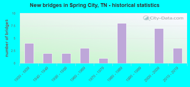
- New bridges - historical statistics
- 41930-1939
- 21940-1949
- 21950-1959
- 31960-1969
- 11970-1979
- 81980-1989
- 72000-2009
- 32010-2019

- Reconstructed bridges - Historical Statistics
- 21960-1969
- 01970-1979
- 01980-1989
- 21990-1999


- Bridge Condition - Deck
- 70.0%Good
- 20.0%Satisfactory
- 10.0%Fair

- Bridge Condition - Superstructure
- 40.0%Good
- 50.0%Satisfactory
- 10.0%Fair

- Bridge Condition - Substructure
- 50.0%Good
- 30.0%Satisfactory
- 10.0%Fair
- 10.0%Poor

- Bridge Condition - Channel
- 41.7%Good
- 33.3%Satisfactory
- 25.0%Fair

- Bridge Condition - Culverts
- 60.0%Good
- 40.0%Satisfactory
Find on map >> Show street view
Structure Number: 72021800001, Location: 3 MI WEST OF US 29 (Lat: 35.714794, Lng: -84.879989), Route carried "on" structure: County highway 2180, Year Built: 1982, Status: Open, Structure Length: 1.04m (3.41ft), Average Daily Traffic: 526 (year 2020), Truck Traffic: 4%, Average Future Daily Traffic: 832 (year 2040), Design Load: HS 20, Features Intersected: OVERFLOW
Minimum Vertical Clearance: 30+ m (98+ ft), Kilometerpoint: 9.592, Lanes on structure: 2, Owner: County Highway Agency, Approaching Roadway Width: 9.8m (32.2ft), Material/Design: Concrete continuous, Design/Construction: Culvert, Number Of Spans In Main Unit: 2, Length of Maximum Span: 4.6m (15.1ft), Curb-To-Curb Width: 9.8m (32.2ft), Out-to-Out Width: 13.4m (44.0ft)
Condition: Channel: Satisfactory, Culverts: Satisfactory, Operating Rating: 40.5 metric tons, Method Used To Determine Operating Rating: Load Factor (LF), Inventory Rating: 24.3 metric tons, Method Used To Determine Inventory Rating: Load Factor (LF), Structural Evaluation: Equal to present minimum criteria, Deck Geometry: Equal to present minimum criteria, Waterway Adequacy: Better than present minimum criteria, Approach Roadway Alignment: Equal to present desirable criteria, Designated Inspection Frequency: Every 24 months, Inspection Date: October 2020, Deck Structure Type: Concrete Cast-file-Place, Wearing Surface/Protective System: Wearing Surface: Bituminous
Find on map >> Show street view
Structure Number: 72021800003, Location: 5 MI WEST OF US 27 (Lat: 35.715067, Lng: -84.879650), Route carried "on" structure: County highway 2180, Year Built: 1982, Status: Open, Structure Length: 3.75m (12.30ft), Average Daily Traffic: 526 (year 2020), Truck Traffic: 4%, Average Future Daily Traffic: 832 (year 2040), Design Load: H 15, Features Intersected: PINEY RIVER
Minimum Vertical Clearance: 30+ m (98+ ft), Kilometerpoint: 9.527, Lanes on structure: 2, Owner: County Highway Agency, Approaching Roadway Width: 9.8m (32.2ft), Skew: 1 degrees, Material/Design: Prestressed concrete, Design/Construction: Stringer/Multi-beam, Number Of Spans In Main Unit: 3, Length of Maximum Span: 14.6m (47.9ft), Curb-To-Curb Width: 9.8m (32.2ft), Out-to-Out Width: 10.4m (34.1ft)
Condition: Deck: Good, Superstructure: Good, Substructure: Satisfactory, Channel: Fair, Operating Rating: 63.3 metric tons, Method Used To Determine Operating Rating: Load Factor (LF), Inventory Rating: 32.4 metric tons, Method Used To Determine Inventory Rating: Load Factor (LF), Structural Evaluation: Equal to present minimum criteria, Deck Geometry: Equal to present minimum criteria, Waterway Adequacy: Better than present minimum criteria, Approach Roadway Alignment: High priority of corrective action, Designated Inspection Frequency: Every 24 months, Inspection Date: October 2020, Deck Structure Type: Concrete Precast Panels, Wearing Surface/Protective System: Wearing Surface: Monolithic Concrete, Deck Protection: Epoxy Coated Reinforcing
Find on map >> Show street view
Structure Number: 720A1930001, Location: .6 MI FROM US 27 (Lat: 35.703767, Lng: -84.849117), Route carried "on" structure: City street 193, Year Built: 1984, Status: Open, Structure Length: 1.01m (3.31ft), Average Daily Traffic: 510 (year 2022), Average Future Daily Traffic: 816 (year 2040), Design Load: HS 20, Features Intersected: VANS CREEK
Minimum Vertical Clearance: 30+ m (98+ ft), Kilometerpoint: 0.966, Lanes on structure: 2, Owner: City or Municipal Highway Agency, Approaching Roadway Width: 4.6m (15.1ft), Skew: 4 degrees, Material/Design: Concrete continuous, Design/Construction: Culvert, Number Of Spans In Main Unit: 2, Length of Maximum Span: 4.6m (15.1ft), Curb-To-Curb Width: 6.7m (22.0ft), Out-to-Out Width: 7.7m (25.3ft)
Condition: Channel: Good, Culverts: Satisfactory, Operating Rating: 89.1 metric tons, Method Used To Determine Operating Rating: Load Factor (LF), Inventory Rating: 32.4 metric tons, Method Used To Determine Inventory Rating: Load Factor (LF), Structural Evaluation: Equal to present minimum criteria, Deck Geometry: Meets minimum limits, Waterway Adequacy: Equal to present minimum criteria, Approach Roadway Alignment: Equal to present desirable criteria, Designated Inspection Frequency: Every 24 months, Inspection Date: October 2020, Deck Structure Type: Concrete Cast-file-Place, Wearing Surface/Protective System: Wearing Surface: Monolithic Concrete, Deck Protection: Epoxy Coated Reinforcing
Find on map >> Show street view
Structure Number: 720A2070001, Location: 4 MI NE OF SPRING CITY (Lat: 35.719750, Lng: -84.797017), Route carried "on" structure: County highway 207, Year Built: 2003, Status: Open, Structure Length: 0.78m (2.56ft), Average Daily Traffic: 10 (year 2022), Truck Traffic: 1%, Average Future Daily Traffic: 16 (year 2040), Design Load: H 20, Features Intersected: MUDDY CREEK
Minimum Vertical Clearance: 30+ m (98+ ft), Kilometerpoint: 1.044, Lanes on structure: 2, Owner: County Highway Agency, Approaching Roadway Width: 3.7m (12.1ft), Skew: 3 degrees, Material/Design: Concrete, Design/Construction: Culvert, Number Of Spans In Main Unit: 2, Length of Maximum Span: 4.5m (14.8ft), Curb-To-Curb Width: 6.7m (22.0ft), Out-to-Out Width: 8.7m (28.5ft)
Condition: Channel: Fair, Culverts: Good, Operating Rating: 68.4 metric tons, Method Used To Determine Operating Rating: Load Factor (LF), Inventory Rating: 32.4 metric tons, Method Used To Determine Inventory Rating: Load Factor (LF), Structural Evaluation: Better than present minimum criteria, Waterway Adequacy: Equal to present minimum criteria, Approach Roadway Alignment: Equal to present minimum criteria, Designated Inspection Frequency: Every 24 months, Inspection Date: October 2020, Deck Structure Type: Corrugated Steel, Wearing Surface/Protective System: Wearing Surface: Bituminous
Find on map >> Show street view
Structure Number: 720A2980001, Location: 2MI EAST OF US 27 (Lat: 35.707092, Lng: -84.809483), Route carried "on" structure: County highway 298, Year Built: 1950, Status: Posted for load, Structure Length: 1.55m (5.09ft), Average Daily Traffic: 40 (year 2022), Truck Traffic: 2%, Average Future Daily Traffic: 64 (year 2040), Features Intersected: MUDDY CREEK
Minimum Vertical Clearance: 30+ m (98+ ft), Kilometerpoint: 2.438, Lanes on structure: 1, Owner: County Highway Agency, Approaching Roadway Width: 4.9m (16.1ft), Material/Design: Steel continuous, Design/Construction: Stringer/Multi-beam, Number Of Spans In Main Unit: 2, Length of Maximum Span: 7.6m (24.9ft), Curb-To-Curb Width: 4.7m (15.4ft), Out-to-Out Width: 4.9m (16.1ft)
Condition: Deck: Fair, Superstructure: Fair, Substructure: Fair, Channel: Fair, Operating Rating: 23.4 metric tons, Method Used To Determine Operating Rating: Load Factor (LF), Inventory Rating: 16.2 metric tons, Method Used To Determine Inventory Rating: Load Factor (LF), Structural Evaluation: Somewhat better than minimum adequacy, Deck Geometry: Better than present minimum criteria, Waterway Adequacy: Somewhat better than minimum adequacy, Approach Roadway Alignment: Equal to present minimum criteria, Bridge Posting: Required (Relationship of Operating Rating to Maximum Legal Load: 0.1 - 9.9% below), Length Of Structure Improvement: 2.23m (7.32ft), Designated Inspection Frequency: Every 24 months, Inspection Date: October 2020, Bridge Improvement Cost: $387,000, Roadway Improvement Cost: $39,000, Total Project Cost: $581,000 ( Estimate for 2020), Deck Structure Type: Corrugated Steel, Wearing Surface/Protective System: Wearing Surface: Bituminous
Find on map >> Show street view
Structure Number: 720A3020001, Location: .01 MI EAST OF US 27 (Lat: 35.675617, Lng: -84.872400), Route carried "on" structure: County highway 302, Year Built: 2010, Status: Open, Structure Length: 1.00m (3.28ft), Average Daily Traffic: 220 (year 2022), Truck Traffic: 4%, Average Future Daily Traffic: 352 (year 2040), Design Load: HS 20, Features Intersected: TOWN CREEK
Minimum Vertical Clearance: 30+ m (98+ ft), Kilometerpoint: 0.027, Lanes on structure: 2, Owner: County Highway Agency, Approaching Roadway Width: 11.1m (36.4ft), Material/Design: Concrete continuous, Design/Construction: Culvert, Number Of Spans In Main Unit: 2, Length of Maximum Span: 4.9m (16.1ft), Curb-To-Curb Width: 10.6m (34.8ft), Out-to-Out Width: 12.0m (39.4ft)
Condition: Channel: Good, Culverts: Good, Operating Rating: 58.5 metric tons, Method Used To Determine Operating Rating: Load Factor (LF), Inventory Rating: 32.4 metric tons, Method Used To Determine Inventory Rating: Load Factor (LF), Structural Evaluation: Better than present minimum criteria, Deck Geometry: Better than present minimum criteria, Waterway Adequacy: Better than present minimum criteria, Approach Roadway Alignment: Equal to present desirable criteria, Designated Inspection Frequency: Every 24 months, Inspection Date: October 2020, Deck Structure Type: Concrete Cast-file-Place, Wearing Surface/Protective System: Wearing Surface: Monolithic Concrete, Deck Protection: Epoxy Coated Reinforcing
Find on map >> Show street view
Structure Number: 720A3020003, Location: .3MI EAST OF US 27 (Lat: 35.688114, Lng: -84.861131), Route carried "on" structure: City street 302, Year Built: 1984, Status: Open, Structure Length: 1.37m (4.49ft), Average Daily Traffic: 410 (year 2022), Truck Traffic: 4%, Average Future Daily Traffic: 656 (year 2040), Design Load: HS 20, Features Intersected: TOWN CREEK
Minimum Vertical Clearance: 30+ m (98+ ft), Kilometerpoint: 1.877, Lanes on structure: 2, Owner: City or Municipal Highway Agency, Approaching Roadway Width: 7.0m (23.0ft), Skew: 3 degrees, Material/Design: Concrete continuous, Design/Construction: Culvert, Number Of Spans In Main Unit: 3, Length of Maximum Span: 3.7m (12.1ft), Curb-To-Curb Width: 6.7m (22.0ft), Out-to-Out Width: 8.1m (26.6ft)
Condition: Channel: Good, Culverts: Good, Operating Rating: 58.5 metric tons, Method Used To Determine Operating Rating: Load Factor (LF), Inventory Rating: 32.4 metric tons, Method Used To Determine Inventory Rating: Load Factor (LF), Structural Evaluation: Better than present minimum criteria, Deck Geometry: Meets minimum limits, Waterway Adequacy: Better than present minimum criteria, Approach Roadway Alignment: Equal to present minimum criteria, Designated Inspection Frequency: Every 24 months, Inspection Date: October 2020, Deck Structure Type: Concrete Cast-file-Place, Wearing Surface/Protective System: Wearing Surface: Bituminous, Deck Protection: Epoxy Coated Reinforcing
Find on map >> Show street view
Structure Number: 720A3070001, Location: .5 MI NORTH OF SR 68 (Lat: 35.651000, Lng: -84.849517), Route carried "on" structure: County highway 307, Year Built: 1960, Status: Open, Structure Length: 0.67m (2.20ft), Average Daily Traffic: 1,090 (year 2022), Truck Traffic: 10%, Average Future Daily Traffic: 1,744 (year 2040), Design Load: H 20, Features Intersected: CRACKER CREEK
Minimum Vertical Clearance: 30+ m (98+ ft), Kilometerpoint: 0.822, Lanes on structure: 2, Owner: County Highway Agency, Approaching Roadway Width: 6.4m (21.0ft), Material/Design: Concrete continuous, Design/Construction: Culvert, Number Of Spans In Main Unit: 2, Length of Maximum Span: 3.0m (9.8ft)
Condition: Channel: Satisfactory, Culverts: Good, Operating Rating: 36.0 metric tons, Method Used To Determine Operating Rating: Load Factor (LF), Inventory Rating: 20.7 metric tons, Method Used To Determine Inventory Rating: Load Factor (LF), Structural Evaluation: Somewhat better than minimum adequacy, Waterway Adequacy: Equal to present minimum criteria, Approach Roadway Alignment: Equal to present desirable criteria, Designated Inspection Frequency: Every 24 months, Inspection Date: October 2020
Find on map >> Show street view
Structure Number: 720A3370001, Location: .01 MI FROM US 27 (Lat: 35.682622, Lng: -84.868056), Route carried "on" structure: City street 337, Year Built: 1955, Status: Open, Structure Length: 1.46m (4.79ft), Average Daily Traffic: 860 (year 2022), Truck Traffic: 4%, Average Future Daily Traffic: 1,376 (year 2040), Design Load: H 15, Features Intersected: TOWN CREEK
Minimum Vertical Clearance: 30+ m (98+ ft), Kilometerpoint: 0.032, Lanes on structure: 2, Owner: City or Municipal Highway Agency, Approaching Roadway Width: 9.1m (29.9ft), Material/Design: Concrete continuous, Design/Construction: Culvert, Number Of Spans In Main Unit: 3, Length of Maximum Span: 4.6m (15.1ft), Curb-To-Curb Width: 7.3m (24.0ft), Out-to-Out Width: 8.9m (29.2ft)
Condition: Channel: Good, Culverts: Good, Operating Rating: 54.9 metric tons, Method Used To Determine Operating Rating: Load Factor (LF), Inventory Rating: 32.4 metric tons, Method Used To Determine Inventory Rating: Load Factor (LF), Structural Evaluation: Better than present minimum criteria, Deck Geometry: Meets minimum limits, Waterway Adequacy: Better than present minimum criteria, Approach Roadway Alignment: Equal to present desirable criteria, Designated Inspection Frequency: Every 24 months, Inspection Date: October 2020, Deck Structure Type: Concrete Cast-file-Place, Wearing Surface/Protective System: Wearing Surface: Bituminous
Find on map >> Show street view
Structure Number: 72F00170001, Location: SPRING CITY LIMITS (Lat: 35.690017, Lng: -84.856650), Route carried "on" structure: State highway 302, Year Built: 1942, Status: Open, Structure Length: 1.52m (4.99ft), Average Daily Traffic: 1,599 (year 2020), Truck Traffic: 5%, Average Future Daily Traffic: 2,768 (year 2040), Design Load: H 15, Features Intersected: TOWN CREEK
Minimum Vertical Clearance: 30+ m (98+ ft), Kilometerpoint: 19.296, Lanes on structure: 2, Owner: State Highway Agency, Approaching Roadway Width: 9.8m (32.2ft), Skew: 3 degrees, Material/Design: Concrete continuous, Design/Construction: Culvert, Number Of Spans In Main Unit: 3, Length of Maximum Span: 4.3m (14.1ft), Curb-To-Curb Width: 8.9m (29.2ft), Out-to-Out Width: 11.0m (36.1ft)
Condition: Channel: Satisfactory, Culverts: Satisfactory, Operating Rating: 32.4 metric tons, Method Used To Determine Operating Rating: Field evaluation and documented engineering judgment, Inventory Rating: 24.3 metric tons, Method Used To Determine Inventory Rating: Field evaluation and documented engineering judgment, Structural Evaluation: Equal to present minimum criteria, Deck Geometry: Somewhat better than minimum adequacy, Waterway Adequacy: Equal to present minimum criteria, Approach Roadway Alignment: Equal to present desirable criteria, Designated Inspection Frequency: Every 24 months, Inspection Date: September 2020
Find on map >> Show street view
Structure Number: 72F00180003, Location: 2MI EAST OF US 27 (Lat: 35.700956, Lng: -84.818714), Route carried "on" structure: County highway 1162, Year Built: 2014, Status: Open, Structure Length: 2.55m (8.37ft), Average Daily Traffic: 392 (year 2020), Truck Traffic: 3%, Average Future Daily Traffic: 528 (year 2040), Design Load: HL 93, Features Intersected: MUDDY CREEK
Minimum Vertical Clearance: 30+ m (98+ ft), Kilometerpoint: 4.394, Lanes on structure: 2, Owner: County Highway Agency, Approaching Roadway Width: 8.2m (26.9ft), Material/Design: Prestressed concrete, Design/Construction: Box Beam or Girders - Single/Spread, Number Of Spans In Main Unit: 1, Length of Maximum Span: 24.6m (80.7ft), Curb-To-Curb Width: 8.2m (26.9ft), Out-to-Out Width: 9.2m (30.2ft)
Condition: Deck: Good, Superstructure: Satisfactory, Substructure: Good, Channel: Good, Operating Rating: 44.1 metric tons, Method Used To Determine Operating Rating: Assigned ratings based on Load and Resistance Factor Design (LRFD) reported by rating factor (RF) using HL93 loadings, Inventory Rating: 32.4 metric tons, Method Used To Determine Inventory Rating: Assigned ratings based on Load and Resistance Factor Design (LRFD) reported by rating factor (RF) using HL93 loadings, Structural Evaluation: Equal to present minimum criteria, Deck Geometry: Somewhat better than minimum adequacy, Waterway Adequacy: Better than present minimum criteria, Approach Roadway Alignment: Equal to present desirable criteria, Designated Inspection Frequency: Every 24 months, Inspection Date: October 2020, Deck Structure Type: Concrete Cast-file-Place, Wearing Surface/Protective System: Wearing Surface: Monolithic Concrete, Deck Protection: Epoxy Coated Reinforcing
Find on map >> Show street view
Structure Number: 72S43800001, Location: 1 MI WEST OF US 27 (Lat: 35.690794, Lng: -84.851778), Route carried "on" structure: City street 1162, Year Built: 1970, Status: Open, Structure Length: 8.05m (26.41ft), Average Daily Traffic: 1,149 (year 2020), Truck Traffic: 3%, Average Future Daily Traffic: 1,920 (year 2040), Design Load: HS 20, Features Intersected: PINEY RIVER
Minimum Vertical Clearance: 30+ m (98+ ft), Kilometerpoint: 0.740, Lanes on structure: 2, Owner: City or Municipal Highway Agency, Approaching Roadway Width: 9.8m (32.2ft), Material/Design: Prestressed concrete, Design/Construction: Stringer/Multi-beam, Number Of Spans In Main Unit: 4, Length of Maximum Span: 20.1m (65.9ft), Curb-To-Curb Width: 9.9m (32.5ft), Out-to-Out Width: 11.0m (36.1ft)
Condition: Deck: Satisfactory, Superstructure: Good, Substructure: Satisfactory, Channel: Fair, Operating Rating: 43.2 metric tons, Method Used To Determine Operating Rating: Load Factor (LF), Inventory Rating: 26.1 metric tons, Method Used To Determine Inventory Rating: Load Factor (LF), Structural Evaluation: Equal to present minimum criteria, Deck Geometry: Somewhat better than minimum adequacy, Waterway Adequacy: Equal to present minimum criteria, Approach Roadway Alignment: Equal to present desirable criteria, Designated Inspection Frequency: Every 24 months, Inspection Date: October 2020, Deck Structure Type: Concrete Cast-file-Place, Wearing Surface/Protective System: Wearing Surface: Monolithic Concrete
Find on map >> Show street view
Structure Number: 72SR0290001, Location: IN DAYTON CITY LIMITS (Lat: 35.473883, Lng: -85.031150), Route carried "on" structure: US 27, Year Built: 1960, Status: Open, Structure Length: 0.64m (2.10ft), Average Daily Traffic: 19,016 (year 2020), Truck Traffic: 9%, Average Future Daily Traffic: 32,576 (year 2040), Design Load: HS 20, Features Intersected: BRANCH, Facility Carried by Structure: FAP 29
Minimum Vertical Clearance: 30+ m (98+ ft), Kilometerpoint: 6.775, Lanes on structure: 3, Base Highway Network: Yes, Owner: State Highway Agency, Approaching Roadway Width: 21.9m (71.9ft), Skew: 10 degrees, Material/Design: Concrete continuous, Design/Construction: Culvert, Number Of Spans In Main Unit: 2, Length of Maximum Span: 3.0m (9.8ft)
Condition: Channel: Satisfactory, Culverts: Satisfactory, Operating Rating: 28.8 metric tons, Method Used To Determine Operating Rating: Load Factor (LF), Inventory Rating: 19.8 metric tons, Method Used To Determine Inventory Rating: Load Factor (LF), Structural Evaluation: Somewhat better than minimum adequacy, Waterway Adequacy: Equal to present desirable criteria, Approach Roadway Alignment: Equal to present desirable criteria, Length Of Structure Improvement: 0.64m (2.10ft), Designated Inspection Frequency: Every 24 months, Inspection Date: September 2020, Bridge Improvement Cost: $184,000, Roadway Improvement Cost: $19,000, Total Project Cost: $277,000 ( Estimate for 2020)
Find on map >> Show street view
Structure Number: 72SR0290011, Location: .7 MI.S.W. OF SPRING CITY (Lat: 35.668333, Lng: -84.875000), Route carried "on" structure: US 27, Year Built: 2011, Status: Open, Structure Length: 3.80m (12.47ft), Average Daily Traffic: 9,314 (year 2020), Truck Traffic: 11%, Average Future Daily Traffic: 14,544 (year 2040), Design Load: HL 93, Features Intersected: TOWN CREEK, Facility Carried by Structure: FAP 29
Minimum Vertical Clearance: 30+ m (98+ ft), Kilometerpoint: 33.281, Lanes on structure: 4, Base Highway Network: Yes, Owner: State Highway Agency, Approaching Roadway Width: 19.2m (63.0ft), Material/Design: Prestressed concrete continuous, Design/Construction: Stringer/Multi-beam, Number Of Spans In Main Unit: 2, Length of Maximum Span: 19.0m (62.3ft), Curb or Sidewalk Widths: Left: 1.5m (4.9ft), Right: 1.5m (4.9ft), Curb-To-Curb Width: 19.2m (63.0ft), Out-to-Out Width: 22.8m (74.8ft)
Condition: Deck: Good, Superstructure: Good, Substructure: Good, Channel: Good, Operating Rating: 54.8 metric tons, Method Used To Determine Operating Rating: Load Factor (LF), Inventory Rating: 32.4 metric tons, Method Used To Determine Inventory Rating: Load Factor (LF), Structural Evaluation: Better than present minimum criteria, Deck Geometry: Equal to present minimum criteria, Waterway Adequacy: Equal to present minimum criteria, Approach Roadway Alignment: Equal to present desirable criteria, Designated Inspection Frequency: Every 24 months, Inspection Date: September 2020, Deck Structure Type: Concrete Cast-file-Place, Wearing Surface/Protective System: Wearing Surface: Monolithic Concrete, Deck Protection: Epoxy Coated Reinforcing
Find on map >> Show street view
Structure Number: 72SR0290013, Location: IN SPRING CITY CITY LIMIT (Lat: 35.694319, Lng: -84.859158), Route carried "on" structure: US 27, Year Built: 2008, Status: Open, Structure Length: 4.04m (13.25ft), Average Daily Traffic: 6,251 (year 2020), Truck Traffic: 11%, Average Future Daily Traffic: 9,872 (year 2041), Design Load: HL 93, Features Intersected: OVERFLOW PINEY RIVER, Facility Carried by Structure: FAP 29
Minimum Vertical Clearance: 30+ m (98+ ft), Kilometerpoint: 36.403, Lanes on structure: 2, Base Highway Network: Yes, Owner: State Highway Agency, Approaching Roadway Width: 19.6m (64.3ft), Material/Design: Prestressed concrete continuous, Design/Construction: Box Beam or Girders - Single/Spread, Number Of Spans In Main Unit: 3, Length of Maximum Span: 13.5m (44.3ft), Curb-To-Curb Width: 19.2m (63.0ft), Out-to-Out Width: 22.9m (75.1ft)
Condition: Deck: Good, Superstructure: Satisfactory, Substructure: Good, Channel: Good, Operating Rating: 63.0 metric tons, Method Used To Determine Operating Rating: Load Factor (LF), Inventory Rating: 32.4 metric tons, Method Used To Determine Inventory Rating: Load Factor (LF), Structural Evaluation: Equal to present minimum criteria, Deck Geometry: Superior to present desirable criteria, Waterway Adequacy: Equal to present desirable criteria, Approach Roadway Alignment: Equal to present desirable criteria, Designated Inspection Frequency: Every 24 months, Inspection Date: September 2020, Deck Structure Type: Concrete Precast Panels, Wearing Surface/Protective System: Wearing Surface: Integral Concrete, Membrane: Epoxy
Find on map >> Show street view
Structure Number: 72SR0290015, Location: CITY LIMITS - SPRING CITY (Lat: 35.697572, Lng: -84.856172), Route carried "on" structure: US 27, Year Built: 2008, Status: Open, Structure Length: 0.77m (2.53ft), Average Daily Traffic: 6,251 (year 2020), Truck Traffic: 11%, Average Future Daily Traffic: 9,872 (year 2040), Design Load: HS 20, Features Intersected: RAVINE, Facility Carried by Structure: FAP 29
Minimum Vertical Clearance: 30+ m (98+ ft), Kilometerpoint: 36.806, Lanes on structure: 5, Base Highway Network: Yes, Owner: State Highway Agency, Approaching Roadway Width: 19.6m (64.3ft), Material/Design: Concrete, Design/Construction: Culvert, Number Of Spans In Main Unit: 2, Length of Maximum Span: 3.7m (12.1ft), Curb-To-Curb Width: 19.2m (63.0ft), Out-to-Out Width: 29.5m (96.8ft)
Condition: Channel: Satisfactory, Culverts: Good, Operating Rating: 84.6 metric tons, Method Used To Determine Operating Rating: Load Factor (LF), Inventory Rating: 32.4 metric tons, Method Used To Determine Inventory Rating: Load Factor (LF), Structural Evaluation: Better than present minimum criteria, Deck Geometry: Meets minimum limits, Waterway Adequacy: Equal to present desirable criteria, Approach Roadway Alignment: Superior to present desirable criteria, Length Of Structure Improvement: 0.77m (2.53ft), Designated Inspection Frequency: Every 24 months, Inspection Date: September 2020, Bridge Improvement Cost: $1,000, Roadway Improvement Cost: $1,000, Total Project Cost: $2,000 ( Estimate for 2020), Deck Structure Type: Concrete Cast-file-Place, Wearing Surface/Protective System: Wearing Surface: Bituminous
Find on map >> Show street view
Structure Number: 72SR0290017, Location: 2.MI.E. OF SPRING CITY (Lat: 35.699750, Lng: -84.854783), Route carried "on" structure: US 27, Year Built: 2008, Status: Open, Structure Length: 10.39m (34.09ft), Average Daily Traffic: 6,251 (year 2020), Truck Traffic: 11%, Average Future Daily Traffic: 9,872 (year 2040), Design Load: HL 93, Features Intersected: PINEY RIVER, Facility Carried by Structure: FAP 29
Minimum Vertical Clearance: 30+ m (98+ ft), Kilometerpoint: 37.015, Lanes on structure: 5, Base Highway Network: Yes, Owner: State Highway Agency, Approaching Roadway Width: 19.2m (63.0ft), Skew: 2 degrees, Material/Design: Prestressed concrete continuous, Design/Construction: Stringer/Multi-beam, Number Of Spans In Main Unit: 4, Length of Maximum Span: 27.4m (89.9ft), Curb or Sidewalk Widths: Left: 1.5m (4.9ft), Right: 1.5m (4.9ft), Curb-To-Curb Width: 19.2m (63.0ft), Out-to-Out Width: 22.9m (75.1ft)
Condition: Deck: Good, Superstructure: Satisfactory, Substructure: Good, Channel: Good, Operating Rating: 59.4 metric tons, Method Used To Determine Operating Rating: Load Factor (LF), Inventory Rating: 32.4 metric tons, Method Used To Determine Inventory Rating: Load Factor (LF), Structural Evaluation: Equal to present minimum criteria, Deck Geometry: Meets minimum limits, Waterway Adequacy: Equal to present desirable criteria, Approach Roadway Alignment: Equal to present desirable criteria, Designated Inspection Frequency: Every 24 months, Inspection Date: September 2020, Deck Structure Type: Concrete Cast-file-Place, Wearing Surface/Protective System: Wearing Surface: Monolithic Concrete, Deck Protection: Epoxy Coated Reinforcing
Find on map >> Show street view
Structure Number: 72SR0290019, Location: .5 MILE N.OF SPRING CITY (Lat: 35.704817, Lng: -84.849800), Route carried "on" structure: US 27, Year Built: 1931, Year Reconstructed: 1998, Status: Open, Structure Length: 0.70m (2.30ft), Average Daily Traffic: 6,251 (year 2020), Truck Traffic: 11%, Average Future Daily Traffic: 9,872 (year 2040), Design Load: H 15, Features Intersected: BRANCH, Facility Carried by Structure: FAP 29
Minimum Vertical Clearance: 30+ m (98+ ft), Kilometerpoint: 37.788, Lanes on structure: 2, Base Highway Network: Yes, Owner: State Highway Agency, Approaching Roadway Width: 24.0m (78.7ft), Material/Design: Concrete continuous, Design/Construction: Culvert, Number Of Spans In Main Unit: 2, Length of Maximum Span: 3.1m (10.2ft)
Condition: Channel: Fair, Culverts: Satisfactory, Operating Rating: 76.5 metric tons, Method Used To Determine Operating Rating: Load Factor (LF), Inventory Rating: 32.4 metric tons, Method Used To Determine Inventory Rating: Load Factor (LF), Structural Evaluation: Equal to present minimum criteria, Waterway Adequacy: Equal to present minimum criteria, Approach Roadway Alignment: Equal to present desirable criteria, Designated Inspection Frequency: Every 24 months, Inspection Date: September 2020
Find on map >> Show street view
Structure Number: 72SR0290021, Location: .7 MILE N.OF SPRING CITY (Lat: 35.705000, Lng: -84.848333), Route carried "on" structure: US 27, Year Built: 1931, Year Reconstructed: 1998, Status: Open, Structure Length: 1.37m (4.49ft), Average Daily Traffic: 6,251 (year 2020), Truck Traffic: 11%, Average Future Daily Traffic: 9,872 (year 2041), Design Load: H 15, Features Intersected: BRANCH, Facility Carried by Structure: FAP 29
Minimum Vertical Clearance: 30+ m (98+ ft), Kilometerpoint: 37.916, Lanes on structure: 2, Base Highway Network: Yes, Owner: State Highway Agency, Approaching Roadway Width: 24.0m (78.7ft), Skew: 1 degrees, Material/Design: Concrete continuous, Design/Construction: Culvert, Number Of Spans In Main Unit: 4, Length of Maximum Span: 3.1m (10.2ft)
Condition: Channel: Fair, Culverts: Satisfactory, Operating Rating: 32.4 metric tons, Method Used To Determine Operating Rating: Field evaluation and documented engineering judgment, Inventory Rating: 24.3 metric tons, Method Used To Determine Inventory Rating: Field evaluation and documented engineering judgment, Structural Evaluation: Equal to present minimum criteria, Waterway Adequacy: Equal to present minimum criteria, Approach Roadway Alignment: Equal to present desirable criteria, Designated Inspection Frequency: Every 24 months, Inspection Date: September 2020
Find on map >> Show street view
Structure Number: 72SR0290029, Location: IN SPRING CITY (Lat: 35.686667, Lng: -84.866667), Route carried "on" structure: State highway 68, Year Built: 1989, Status: Open, Structure Length: 9.42m (30.91ft), Average Daily Traffic: 3,439 (year 2020), Truck Traffic: 7%, Average Future Daily Traffic: 5,184 (year 2041), Design Load: HS 20, Features Intersected: SR 68 / SR 29 & SOU RR
Minimum Vertical Clearance: 30+ m (98+ ft), Kilometerpoint: 13.358, Lanes on structure: 2, Lanes under structure: 2, Base Highway Network: Yes, Owner: State Highway Agency, Approaching Roadway Width: 14.6m (47.9ft), Material/Design: Steel continuous, Design/Construction: Stringer/Multi-beam, Number Of Spans In Main Unit: 3, Length of Maximum Span: 37.5m (123.0ft), Curb-To-Curb Width: 14.6m (47.9ft), Out-to-Out Width: 15.2m (49.9ft)
Condition: Deck: Good, Superstructure: Good, Substructure: Poor, Operating Rating: 49.5 metric tons, Method Used To Determine Operating Rating: Load Factor (LF), Inventory Rating: 24.3 metric tons, Method Used To Determine Inventory Rating: Load Factor (LF), Structural Evaluation: Meets minimum limits, Deck Geometry: Superior to present desirable criteria, Underclear: Superior to present desirable criteria, Approach Roadway Alignment: Equal to present minimum criteria, Length Of Structure Improvement: 9.42m (30.91ft), Designated Inspection Frequency: Every 24 months, Inspection Date: September 2020, Bridge Improvement Cost: $2,432,000, Roadway Improvement Cost: $244,000, Total Project Cost: $3,649,000 ( Estimate for 2021), Deck Structure Type: Concrete Cast-file-Place, Wearing Surface/Protective System: Wearing Surface: Monolithic Concrete, Deck Protection: Epoxy Coated Reinforcing
Find on map >> Show street view
Structure Number: 72SR0600001, Location: 2.12 MI.N.OF TENN.RIVER (Lat: 35.440761, Lng: -85.013097), Route carried "on" structure: County highway 2279, Year Built: 2002, Status: Open, Structure Length: 1.12m (3.67ft), Average Daily Traffic: 695 (year 2020), Truck Traffic: 3%, Average Future Daily Traffic: 1,088 (year 2040), Design Load: HS 20, Features Intersected: BRANCH
Minimum Vertical Clearance: 30+ m (98+ ft), Kilometerpoint: 0.885, Lanes on structure: 2, Owner: County Highway Agency, Approaching Roadway Width: 11.0m (36.1ft), Skew: 4 degrees, Material/Design: Concrete continuous, Design/Construction: Culvert, Number Of Spans In Main Unit: 2, Length of Maximum Span: 3.7m (12.1ft), Curb-To-Curb Width: 8.5m (27.9ft), Out-to-Out Width: 11.1m (36.4ft)
Condition: Channel: Good, Culverts: Good, Operating Rating: 87.3 metric tons, Method Used To Determine Operating Rating: Load Factor (LF), Inventory Rating: 32.4 metric tons, Method Used To Determine Inventory Rating: Load Factor (LF), Structural Evaluation: Better than present minimum criteria, Deck Geometry: Somewhat better than minimum adequacy, Waterway Adequacy: Equal to present desirable criteria, Approach Roadway Alignment: Equal to present minimum criteria, Designated Inspection Frequency: Every 24 months, Inspection Date: October 2020, Deck Structure Type: Concrete Cast-file-Place, Wearing Surface/Protective System: Wearing Surface: Bituminous
Find on map >> Show street view
Structure Number: 72SR0680001, Location: 3.4 MI.NE.OF SPRING CITY (Lat: 35.745128, Lng: -84.840567), Route carried "on" structure: State highway 68, Year Built: 1962, Status: Open, Structure Length: 0.70m (2.30ft), Average Daily Traffic: 2,310 (year 2020), Truck Traffic: 18%, Average Future Daily Traffic: 3,536 (year 2040), Design Load: H 15, Features Intersected: LITTLE PINEY RIVER
Minimum Vertical Clearance: 30+ m (98+ ft), Kilometerpoint: 5.488, Lanes on structure: 2, Base Highway Network: Yes, Owner: State Highway Agency, Approaching Roadway Width: 10.7m (35.1ft), Material/Design: Concrete continuous, Design/Construction: Culvert, Number Of Spans In Main Unit: 2, Length of Maximum Span: 3.0m (9.8ft)
Condition: Channel: Satisfactory, Culverts: Good, Operating Rating: 36.0 metric tons, Method Used To Determine Operating Rating: Load Factor (LF), Inventory Rating: 19.8 metric tons, Method Used To Determine Inventory Rating: Load Factor (LF), Structural Evaluation: Somewhat better than minimum adequacy, Waterway Adequacy: Equal to present minimum criteria, Approach Roadway Alignment: Equal to present desirable criteria, Designated Inspection Frequency: Every 24 months, Inspection Date: September 2020
Find on map >> Show street view
Structure Number: 72SR0680003, Location: CITY LIMITS - SPRING CITY (Lat: 35.703556, Lng: -84.870486), Route carried "on" structure: State highway 68, Year Built: 1930, Year Reconstructed: 1972, Status: Open, Structure Length: 5.64m (18.50ft), Average Daily Traffic: 3,791 (year 2020), Truck Traffic: 7%, Average Future Daily Traffic: 5,456 (year 2041), Design Load: HS 20+Mod, Features Intersected: PINEY RIVER
Minimum Vertical Clearance: 30+ m (98+ ft), Kilometerpoint: 11.298, Lanes on structure: 2, Base Highway Network: Yes, Owner: State Highway Agency, Approaching Roadway Width: 13.7m (44.9ft), Material/Design: Prestressed concrete continuous, Design/Construction: Box Beam or Girders - Single/Spread, Number Of Spans In Main Unit: 4, Length of Maximum Span: 14.0m (45.9ft), Curb-To-Curb Width: 14.2m (46.6ft), Out-to-Out Width: 15.3m (50.2ft)
Condition: Deck: Satisfactory, Superstructure: Satisfactory, Substructure: Satisfactory, Channel: Satisfactory, Operating Rating: 78.3 metric tons, Method Used To Determine Operating Rating: Load Factor (LF), Inventory Rating: 32.4 metric tons, Method Used To Determine Inventory Rating: Load Factor (LF), Structural Evaluation: Equal to present minimum criteria, Deck Geometry: Superior to present desirable criteria, Waterway Adequacy: Equal to present desirable criteria, Approach Roadway Alignment: Equal to present desirable criteria, Designated Inspection Frequency: Every 24 months, Inspection Date: September 2020, Deck Structure Type: Concrete Cast-file-Place, Wearing Surface/Protective System: Wearing Surface: Bituminous, Membrane: Preformed Fabric
Find on map >> Show street view
Structure Number: 72SR0680005, Location: CITY LIMITS - SPRING CITY (Lat: 35.701833, Lng: -84.870983), Route carried "on" structure: State highway 68, Year Built: 1930, Year Reconstructed: 1972, Status: Open, Structure Length: 1.95m (6.40ft), Average Daily Traffic: 3,791 (year 2020), Truck Traffic: 7%, Average Future Daily Traffic: 5,456 (year 2040), Design Load: HS 20+Mod, Features Intersected: FORK OF PINEY RIVER
Minimum Vertical Clearance: 30+ m (98+ ft), Kilometerpoint: 11.523, Lanes on structure: 2, Base Highway Network: Yes, Owner: State Highway Agency, Approaching Roadway Width: 13.4m (44.0ft), Material/Design: Prestressed concrete, Design/Construction: Box Beam or Girders - Single/Spread, Number Of Spans In Main Unit: 1, Length of Maximum Span: 18.9m (62.0ft), Curb-To-Curb Width: 14.2m (46.6ft), Out-to-Out Width: 15.3m (50.2ft)
Condition: Deck: Good, Superstructure: Satisfactory, Substructure: Good, Channel: Satisfactory, Operating Rating: 71.1 metric tons, Method Used To Determine Operating Rating: Load Factor (LF), Inventory Rating: 32.4 metric tons, Method Used To Determine Inventory Rating: Load Factor (LF), Structural Evaluation: Equal to present minimum criteria, Deck Geometry: Superior to present desirable criteria, Waterway Adequacy: Equal to present minimum criteria, Approach Roadway Alignment: Equal to present desirable criteria, Designated Inspection Frequency: Every 24 months, Inspection Date: September 2020, Deck Structure Type: Concrete Cast-file-Place, Wearing Surface/Protective System: Wearing Surface: Bituminous, Membrane: Preformed Fabric
Find on map >> Show street view
Structure Number: 72SR0680007, Location: 3 MI.EAST OF SPRING CITY (Lat: 35.646667, Lng: -84.861667), Route carried "on" structure: State highway 68, Year Built: 1941, Status: Open, Structure Length: 0.70m (2.30ft), Average Daily Traffic: 5,021 (year 2020), Truck Traffic: 11%, Average Future Daily Traffic: 8,034 (year 2041), Design Load: H 15, Features Intersected: WOLF CREEK
Minimum Vertical Clearance: 30+ m (98+ ft), Kilometerpoint: 15.820, Lanes on structure: 2, Base Highway Network: Yes, Owner: State Highway Agency, Approaching Roadway Width: 9.1m (29.9ft), Material/Design: Concrete continuous, Design/Construction: Culvert, Number Of Spans In Main Unit: 2, Length of Maximum Span: 3.0m (9.8ft)
Condition: Channel: Good, Culverts: Good, Operating Rating: 32.4 metric tons, Method Used To Determine Operating Rating: Field evaluation and documented engineering judgment, Inventory Rating: 24.3 metric tons, Method Used To Determine Inventory Rating: Field evaluation and documented engineering judgment, Structural Evaluation: Equal to present minimum criteria, Waterway Adequacy: Superior to present desirable criteria, Approach Roadway Alignment: Equal to present desirable criteria, Designated Inspection Frequency: Every 24 months, Inspection Date: September 2020
Find on map >> Show street view
Structure Number: 72SR0290029, Location: IN SPRING CITY (Lat: 35.685000, Lng: -84.865000), Route carried "under" structure: US 27, Year Built: 1989, Structure Length: 0. m, Average Daily Traffic: 9,314 (year 2020), Truck Traffic: 11%, Features Intersected: SR68 / SR 29 & SOU RR, Facility Carried by Structure: FAP 68
Minimum Vertical Clearance: 9.80m (32.15ft), Kilometerpoint: 35.374, Lanes on structure: 2, Lanes under structure: 2, Material/Design: Steel continuous, Design/Construction: Stringer/Multi-beam, Length of Maximum Span: 37.5m (123.0ft)
Find on map >> Show street view
Structure Number: 72SR0290031, Location: IN SPRING CITY (Lat: 35.557767, Lng: -84.956633), Route carried "under" structure: State highway 5720, Year Built: 2002, Structure Length: 0. m, Average Daily Traffic: 492 (year 2020), Truck Traffic: 3%, Features Intersected: SR 29, Facility Carried by Structure: FAP 68
Minimum Vertical Clearance: 9.30m (30.51ft), Kilometerpoint: 0.322, Lanes on structure: 2, Lanes under structure: 2, Material/Design: Prestressed concrete continuous, Design/Construction: Stringer/Multi-beam, Length of Maximum Span: 20.1m (65.9ft)
Find on map >> Show street view
Structure Number: 72SR0290032, Location: IN SPRING CITY (Lat: 35.558100, Lng: -84.956883), Route carried "under" structure: State highway 5720, Year Built: 2002, Structure Length: 0. m, Average Daily Traffic: 492 (year 2020), Truck Traffic: 3%, Features Intersected: SR 29, Facility Carried by Structure: FAP 68
Minimum Vertical Clearance: 9.27m (30.41ft), Kilometerpoint: 0.290, Lanes on structure: 2, Lanes under structure: 2, Material/Design: Prestressed concrete continuous, Design/Construction: Stringer/Multi-beam, Length of Maximum Span: 20.3m (66.6ft)
Find on map >> Show street view
Structure Number: 72SR0290033, Location: IN SPRING CITY (Lat: 35.685000, Lng: -84.865000), Route carried "under" structure: State highway 2290, Year Built: 1989, Structure Length: 0. m, Average Daily Traffic: 1,004 (year 2020), Truck Traffic: 3%, Features Intersected: SR 29, Facility Carried by Structure: FAP 68
Minimum Vertical Clearance: 6.76m (22.18ft), Kilometerpoint: 4.828, Lanes on structure: 2, Lanes under structure: 2, Material/Design: Prestressed concrete continuous, Design/Construction: Stringer/Multi-beam, Length of Maximum Span: 37.5m (123.0ft)
Find on map >> Show street view
Structure Number: 72SR0290034, Location: IN SPRING CITY (Lat: 35.685000, Lng: -84.865000), Route carried "under" structure: State highway 2290, Year Built: 1989, Structure Length: 0. m, Average Daily Traffic: 1,004 (year 2020), Truck Traffic: 3%, Features Intersected: SR 29, Facility Carried by Structure: FAP 68
Minimum Vertical Clearance: 6.88m (22.57ft), Kilometerpoint: 4.860, Lanes on structure: 2, Lanes under structure: 2, Material/Design: Prestressed concrete continuous, Design/Construction: Stringer/Multi-beam, Length of Maximum Span: 37.5m (123.0ft)