Bridge Statistics for St. Matthews, Kentucky (KY)
Condition, Traffic, Stress, Structural Evaluation, Project Costs
- National Bridge Inventory (NBI) Statistics
- 25Number of bridges
- 285ft / 86.7mTotal length
- $1,527,000Total costs
- 709,867Total average daily traffic
- 44,580Total average daily truck traffic
- National Bridge Inventory (NBI) Registered Bridges for St. Matthews
- No street view available for this location
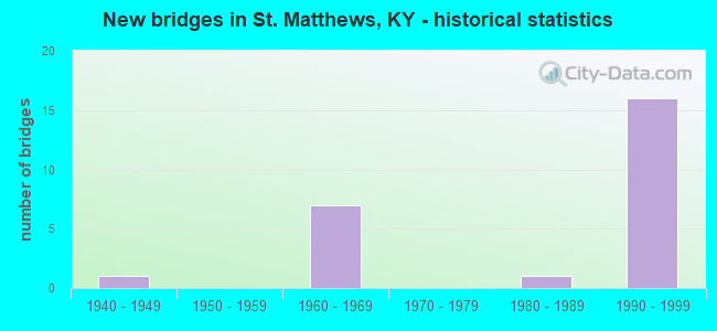
- New bridges - historical statistics
- 11940-1949
- 71960-1969
- 11980-1989
- 161990-1999

- Reconstructed bridges - Historical Statistics
- 12000-2009
- 12010-2019


- Bridge Condition - Deck
- 41.7%Good
- 8.3%Satisfactory
- 41.7%Fair
- 8.3%Poor

- Bridge Condition - Superstructure
- 25.0%Good
- 41.7%Satisfactory
- 16.7%Fair
- 16.7%Poor

- Bridge Condition - Substructure
- 25.0%Good
- 33.3%Satisfactory
- 41.7%Fair

- Bridge Condition - Channel
- 9.1%Very good
- 63.6%Good
- 27.3%Satisfactory
Find on map >> Show street view
Structure Number: 56B00052L, Location: 0.8 MI W OF I-264 NTRCH (Lat: 38.236111, Lng: -85.635556), Route carried "on" structure: Interstate 64, Year Built: 1966, Status: Open, Structure Length: 3.56m (11.68ft), Average Daily Traffic: 23,876 (year 2020), Truck Traffic: 8%, Average Future Daily Traffic: 25,547 (year 2040), Design Load: HS 20, Features Intersected: MID FK BEARGRASS CREEK
Minimum Vertical Clearance: 30+ m (98+ ft), Kilometerpoint: 18.610, Lanes on structure: 2, Base Highway Network: Yes, Owner: State Highway Agency, Approaching Roadway Width: 11.6m (38.1ft), Skew: 1 degrees, Material/Design: Steel, Design/Construction: Stringer/Multi-beam, Number Of Spans In Main Unit: 3, Length of Maximum Span: 19.8m (65.0ft), Curb-To-Curb Width: 11.6m (38.1ft), Out-to-Out Width: 12.8m (42.0ft)
Condition: Deck: Fair, Superstructure: Poor, Substructure: Fair, Channel: Good, Operating Rating: 52.3 metric tons, Method Used To Determine Operating Rating: Load Factor (LF), Inventory Rating: 31.4 metric tons, Method Used To Determine Inventory Rating: Load Factor (LF), Structural Evaluation: Meets minimum limits, Deck Geometry: Equal to present minimum criteria, Waterway Adequacy: Superior to present desirable criteria, Approach Roadway Alignment: Equal to present desirable criteria, Designated Inspection Frequency: Every 24 months, Inspection Date: April 2021, Deck Structure Type: Concrete Cast-file-Place, Wearing Surface/Protective System: Wearing Surface: Latex Concrete
Find on map >> Show street view
Structure Number: 56B00052R, Location: 0.8 MI W OF I-264 NTRCH (Lat: 38.235833, Lng: -85.635556), Route carried "on" structure: Interstate 64, Year Built: 1966, Status: Open, Structure Length: 3.52m (11.55ft), Average Daily Traffic: 23,876 (year 2020), Truck Traffic: 8%, Average Future Daily Traffic: 25,547 (year 2040), Design Load: HS 20, Features Intersected: MID FK BEARGRASS CREEK
Minimum Vertical Clearance: 30+ m (98+ ft), Kilometerpoint: 18.960, Lanes on structure: 2, Base Highway Network: Yes, Owner: State Highway Agency, Approaching Roadway Width: 11.6m (38.1ft), Skew: 1 degrees, Material/Design: Steel, Design/Construction: Stringer/Multi-beam, Number Of Spans In Main Unit: 3, Length of Maximum Span: 19.8m (65.0ft), Curb-To-Curb Width: 11.6m (38.1ft), Out-to-Out Width: 12.8m (42.0ft)
Condition: Deck: Poor, Superstructure: Poor, Substructure: Fair, Channel: Good, Operating Rating: 52.3 metric tons, Method Used To Determine Operating Rating: Load Factor (LF), Inventory Rating: 31.4 metric tons, Method Used To Determine Inventory Rating: Load Factor (LF), Structural Evaluation: Meets minimum limits, Deck Geometry: Equal to present minimum criteria, Waterway Adequacy: Superior to present desirable criteria, Approach Roadway Alignment: Equal to present desirable criteria, Designated Inspection Frequency: Every 24 months, Inspection Date: April 2021, Deck Structure Type: Concrete Cast-file-Place, Wearing Surface/Protective System: Wearing Surface: Latex Concrete
Find on map >> Show street view
Structure Number: 56B00118N, Location: 0.6 MI N OF I-264 NTRCH (Lat: 38.235833, Lng: -85.641667), Route carried "on" structure: State highway 1932, Year Built: 1966, Status: Posted for load, Structure Length: 7.59m (24.90ft), Average Daily Traffic: 18,652 (year 2020), Truck Traffic: 5%, Average Future Daily Traffic: 17,346 (year 2040), Design Load: HS 20, Features Intersected: I-64
Minimum Vertical Clearance: 30+ m (98+ ft), Kilometerpoint: 6.645, Lanes on structure: 4, Lanes under structure: 4, Owner: State Highway Agency, Approaching Roadway Width: 16.5m (54.1ft), Skew: 23 degrees, Material/Design: Steel continuous, Design/Construction: Stringer/Multi-beam, Number Of Spans In Main Unit: 4, Length of Maximum Span: 21.0m (68.9ft), Curb or Sidewalk Widths: Left: 1.5m (4.9ft), Right: 1.5m (4.9ft), Curb-To-Curb Width: 16.5m (54.1ft), Out-to-Out Width: 21.3m (69.9ft)
Condition: Deck: Fair, Superstructure: Satisfactory, Substructure: Fair, Operating Rating: 49.0 metric tons, Method Used To Determine Operating Rating: Load Factor (LF), Inventory Rating: 29.4 metric tons, Method Used To Determine Inventory Rating: Load Factor (LF), Structural Evaluation: Somewhat better than minimum adequacy, Deck Geometry: Meets minimum limits, Underclear: Meets minimum limits, Approach Roadway Alignment: Equal to present desirable criteria, Bridge Posting: Required (Relationship of Operating Rating to Maximum Legal Load: 10.0 - 19.9% below), Designated Inspection Frequency: Every 24 months, Inspection Date: August 2021, Deck Structure Type: Concrete Cast-file-Place, Wearing Surface/Protective System: Wearing Surface: Latex Concrete
Find on map >> Show street view
Structure Number: 56B00120N, Location: 0.45 MI N OF I-264 NTRCH (Lat: 38.233889, Lng: -85.640000), Route carried "on" structure: State highway 1932, Year Built: 1966, Status: Open, Structure Length: 3.79m (12.43ft), Average Daily Traffic: 18,652 (year 2020), Truck Traffic: 5%, Average Future Daily Traffic: 17,346 (year 2040), Design Load: HS 20, Features Intersected: MID FK BEARGRASS CREEK
Minimum Vertical Clearance: 30+ m (98+ ft), Kilometerpoint: 6.391, Lanes on structure: 4, Owner: State Highway Agency, Approaching Roadway Width: 19.5m (64.0ft), Skew: 20 degrees, Material/Design: Steel, Design/Construction: Stringer/Multi-beam, Number Of Spans In Main Unit: 3, Length of Maximum Span: 18.7m (61.4ft), Curb or Sidewalk Widths: Left: 1.5m (4.9ft), Right: 1.5m (4.9ft), Curb-To-Curb Width: 17.7m (58.1ft), Out-to-Out Width: 21.3m (69.9ft)
Condition: Deck: Fair, Superstructure: Satisfactory, Substructure: Fair, Channel: Good, Operating Rating: 53.5 metric tons, Method Used To Determine Operating Rating: Load Factor (LF), Inventory Rating: 32.1 metric tons, Method Used To Determine Inventory Rating: Load Factor (LF), Structural Evaluation: Somewhat better than minimum adequacy, Deck Geometry: Somewhat better than minimum adequacy, Waterway Adequacy: Superior to present desirable criteria, Approach Roadway Alignment: Equal to present desirable criteria, Designated Inspection Frequency: Every 24 months, Inspection Date: August 2021, Deck Structure Type: Concrete Cast-file-Place, Wearing Surface/Protective System: Wearing Surface: Latex Concrete
Find on map >> Show street view
Structure Number: 56B00440N, Location: 0.4 MI S OF BOWLING BLVD (Lat: 38.236944, Lng: -85.631389), Route carried "on" structure: County highway 1003, Year Built: 1993, Status: Open, Structure Length: 10.23m (33.56ft), Average Daily Traffic: 22,386 (year 2018), Average Future Daily Traffic: 20,818 (year 2038), Design Load: HS 25 or greater, Features Intersected: I-64, Facility Carried by Structure: BROWNS LN
Minimum Vertical Clearance: 30+ m (98+ ft), Kilometerpoint: 2.250, Lanes on structure: 4, Lanes under structure: 8, Owner: State Highway Agency, Approaching Roadway Width: 20.7m (67.9ft), Skew: 3 degrees, Material/Design: Prestressed concrete continuous, Design/Construction: Stringer/Multi-beam, Number Of Spans In Main Unit: 5, Length of Maximum Span: 28.0m (91.9ft), Curb-To-Curb Width: 20.7m (67.9ft), Out-to-Out Width: 21.7m (71.2ft)
Condition: Deck: Satisfactory, Superstructure: Satisfactory, Substructure: Good, Operating Rating: 79.2 metric tons, Method Used To Determine Operating Rating: Load Factor (LF), Inventory Rating: 47.5 metric tons, Method Used To Determine Inventory Rating: Load Factor (LF), Structural Evaluation: Equal to present minimum criteria, Deck Geometry: Superior to present desirable criteria, Underclear: Equal to present minimum criteria, Approach Roadway Alignment: Equal to present desirable criteria, Designated Inspection Frequency: Every 24 months, Inspection Date: April 2021, Deck Structure Type: Concrete Cast-file-Place, Wearing Surface/Protective System: Wearing Surface: Monolithic Concrete, Deck Protection: Epoxy Coated Reinforcing
Find on map >> Show street view
Structure Number: 56B00443N, Location: 0.9 MI E OF KY 1932 NTRCH (Lat: 38.238056, Lng: -85.625833), Route carried "on" structure: Ramp Interstate 64, Year Built: 1994, Year Reconstructed: 2019, Status: Open, Structure Length: 9.49m (31.14ft), Average Daily Traffic: 91,516 (year 2020), Truck Traffic: 8%, Average Future Daily Traffic: 97,922 (year 2040), Design Load: HS 25 or greater, Features Intersected: I-64 & RAMP
Minimum Vertical Clearance: 30+ m (98+ ft), Kilometerpoint: 19.840, Lanes on structure: 2, Lanes under structure: 8, Owner: State Highway Agency, Approaching Roadway Width: 10.4m (34.1ft), Skew: 1 degrees, Material/Design: Prestressed concrete continuous, Design/Construction: Stringer/Multi-beam, Number Of Spans In Main Unit: 4, Length of Maximum Span: 30.8m (101.0ft), Curb-To-Curb Width: 10.4m (34.1ft), Out-to-Out Width: 11.3m (37.1ft)
Condition: Deck: Good, Superstructure: Good, Substructure: Good, Operating Rating: 74.3 metric tons, Method Used To Determine Operating Rating: Load Factor (LF), Inventory Rating: 44.6 metric tons, Method Used To Determine Inventory Rating: Load Factor (LF), Structural Evaluation: Better than present minimum criteria, Deck Geometry: Better than present minimum criteria, Underclear: Equal to present minimum criteria, Approach Roadway Alignment: Equal to present desirable criteria, Length Of Structure Improvement: 0.93m (3.05ft), Designated Inspection Frequency: Every 24 months, Inspection Date: April 2021, Bridge Improvement Cost: $1,082,000, Total Project Cost: $1,082,000, Deck Structure Type: Concrete Cast-file-Place, Wearing Surface/Protective System: Wearing Surface: Epoxy Overlay, Deck Protection: Epoxy Coated Reinforcing
Find on map >> Show street view
Structure Number: 56B00445N, Location: 0.95 MI E OF I-64 (Lat: 38.250833, Lng: -85.620278), Route carried "on" structure: Ramp Interstate 264, Year Built: 1994, Status: Open, Structure Length: 31.83m (104.43ft), Average Daily Traffic: 48,500 (year 2009), Truck Traffic: 7%, Average Future Daily Traffic: 51,895 (year 2029), Design Load: HS 25 or greater, Features Intersected: I-264, RAMPS & US 60
Minimum Vertical Clearance: 30+ m (98+ ft), Kilometerpoint: 0.332, Lanes on structure: 2, Lanes under structure: 19, Owner: State Highway Agency, Approaching Roadway Width: 10.4m (34.1ft), Skew: 9 degrees, Material/Design: Prestressed concrete continuous, Design/Construction: Stringer/Multi-beam, Number Of Spans In Main Unit: 12, Length of Maximum Span: 29.8m (97.8ft), Curb-To-Curb Width: 10.4m (34.1ft), Out-to-Out Width: 11.4m (37.4ft)
Condition: Deck: Good, Superstructure: Good, Substructure: Satisfactory, Operating Rating: 84.8 metric tons, Method Used To Determine Operating Rating: Load Factor (LF), Inventory Rating: 50.9 metric tons, Method Used To Determine Inventory Rating: Load Factor (LF), Structural Evaluation: Equal to present minimum criteria, Deck Geometry: Better than present minimum criteria, Underclear: High priority of corrective action, Approach Roadway Alignment: Equal to present desirable criteria, Designated Inspection Frequency: Every 24 months, Inspection Date: April 2021, Deck Structure Type: Concrete Cast-file-Place, Wearing Surface/Protective System: Wearing Surface: Epoxy Overlay, Deck Protection: Epoxy Coated Reinforcing
Find on map >> Show street view
Structure Number: 56C00045N, Location: 0.3 MI N OF DUTCHMANS LN (Lat: 38.235000, Lng: -85.636667), Route carried "on" structure: City street 1436, Year Built: 1960, Status: Posted for load, Structure Length: 1.89m (6.20ft), Average Daily Traffic: 7,378 (year 2009), Average Future Daily Traffic: 6,935 (year 2029), Features Intersected: MID FORK BEARGRASS CREEK, Facility Carried by Structure: DUPONT RD
Minimum Vertical Clearance: 30+ m (98+ ft), Kilometerpoint: 0.404, Lanes on structure: 2, Owner: City or Municipal Highway Agency, Approaching Roadway Width: 7.4m (24.3ft), Material/Design: Prestressed concrete, Design/Construction: Stringer/Multi-beam, Number Of Spans In Main Unit: 1, Length of Maximum Span: 18.0m (59.1ft), Curb or Sidewalk Widths: Left: 1.2m (3.9ft), Right: 1.2m (3.9ft), Curb-To-Curb Width: 7.4m (24.3ft), Out-to-Out Width: 10.5m (34.4ft)
Condition: Deck: Good, Superstructure: Good, Substructure: Good, Channel: Good, Operating Rating: 16.4 metric tons, Method Used To Determine Operating Rating: Field evaluation and documented engineering judgment, Inventory Rating: 16.4 metric tons, Method Used To Determine Inventory Rating: Field evaluation and documented engineering judgment, Structural Evaluation: Meets minimum limits, Deck Geometry: High priority of replacement, Waterway Adequacy: Equal to present desirable criteria, Approach Roadway Alignment: Equal to present desirable criteria, Bridge Posting: Required (Relationship of Operating Rating to Maximum Legal Load: > 39.9% below), Length Of Structure Improvement: 0.19m (0.62ft), Designated Inspection Frequency: Every 24 months, Inspection Date: December 2021, Bridge Improvement Cost: $266,000, Total Project Cost: $265,000, Deck Structure Type: Concrete Cast-file-Place, Wearing Surface/Protective System: Wearing Surface: Monolithic Concrete
Find on map >> Show street view
Structure Number: 56C00046N, Location: 0.15 MI E OF KY 1932 (Lat: 38.233056, Lng: -85.636389), Route carried "on" structure: County highway 1027, Year Built: 1940, Year Reconstructed: 2005, Status: Posted for load, Structure Length: 0.73m (2.40ft), Average Daily Traffic: 14,859 (year 2020), Average Future Daily Traffic: 13,818 (year 2040), Features Intersected: WEICHER CREEK, Facility Carried by Structure: DUTCHMANS LN
Minimum Vertical Clearance: 30+ m (98+ ft), Kilometerpoint: 0.391, Lanes on structure: 4, Owner: County Highway Agency, Approaching Roadway Width: 16.8m (55.1ft), Material/Design: Concrete, Design/Construction: Slab, Number Of Spans In Main Unit: 2, Length of Maximum Span: 3.4m (11.2ft), Curb or Sidewalk Widths: Left: 1.6m (5.2ft), Right: 2.2m (7.2ft), Curb-To-Curb Width: 16.8m (55.1ft), Out-to-Out Width: 21.1m (69.2ft)
Condition: Deck: Fair, Superstructure: Fair, Substructure: Fair, Channel: Satisfactory, Operating Rating: 16.3 metric tons, Method Used To Determine Operating Rating: Field evaluation and documented engineering judgment, Inventory Rating: 16.3 metric tons, Method Used To Determine Inventory Rating: Field evaluation and documented engineering judgment, Structural Evaluation: Meets minimum limits, Deck Geometry: Somewhat better than minimum adequacy, Waterway Adequacy: Equal to present desirable criteria, Approach Roadway Alignment: Equal to present desirable criteria, Bridge Posting: Required (Relationship of Operating Rating to Maximum Legal Load: > 39.9% below), Length Of Structure Improvement: 0.07m (0.23ft), Designated Inspection Frequency: Every 24 months, Inspection Date: December 2021, Bridge Improvement Cost: $181,000, Total Project Cost: $180,000, Deck Structure Type: Concrete Cast-file-Place, Wearing Surface/Protective System: Wearing Surface: Bituminous
Find on map >> Show street view
Structure Number: 56C00101N, Location: 0.25 MI S OF RIVER RD (Lat: 38.276389, Lng: -85.693611), Route carried "on" structure: Bypass County highway 1004, Year Built: 1966, Status: Open, Structure Length: 0.76m (2.49ft), Average Daily Traffic: 1,248 (year 2018), Average Future Daily Traffic: 1,160 (year 2038), Features Intersected: MUDDY FORK, Facility Carried by Structure: MOCKINGBIRD VALLEY
Minimum Vertical Clearance: 30+ m (98+ ft), Kilometerpoint: 2.309, Lanes on structure: 2, Owner: County Highway Agency, Approaching Roadway Width: 6.4m (21.0ft), Material/Design: Concrete, Design/Construction: Culvert, Number Of Spans In Main Unit: 2, Length of Maximum Span: 3.7m (12.1ft)
Condition: Channel: Satisfactory, Culverts: Satisfactory, Operating Rating: 54.4 metric tons, Method Used To Determine Operating Rating: Field evaluation and documented engineering judgment, Inventory Rating: 39.9 metric tons, Method Used To Determine Inventory Rating: Field evaluation and documented engineering judgment, Structural Evaluation: Equal to present minimum criteria, Waterway Adequacy: Meets minimum limits, Approach Roadway Alignment: Equal to present desirable criteria, Designated Inspection Frequency: Every 24 months, Inspection Date: January 2020
Find on map >> Show street view
Structure Number: 56C00170N, Location: 0.1 MI N OF SHERBURN LN (Lat: 38.240278, Lng: -85.634722), Route carried "on" structure: County highway 1003, Year Built: 1982, Status: Open, Structure Length: 2.38m (7.81ft), Average Daily Traffic: 22,386 (year 2018), Average Future Daily Traffic: 20,818 (year 2038), Design Load: HS 20, Features Intersected: MID FORK BEARGRASS CREEK, Facility Carried by Structure: BROWNS LN
Minimum Vertical Clearance: 30+ m (98+ ft), Kilometerpoint: 1.765, Lanes on structure: 2, Owner: County Highway Agency, Approaching Roadway Width: 12.2m (40.0ft), Material/Design: Prestressed concrete, Design/Construction: Box Beam or Girders - Multiple, Number Of Spans In Main Unit: 3, Length of Maximum Span: 7.9m (25.9ft), Curb-To-Curb Width: 12.8m (42.0ft), Out-to-Out Width: 13.8m (45.3ft)
Condition: Deck: Good, Superstructure: Satisfactory, Substructure: Satisfactory, Channel: Good, Operating Rating: 83.2 metric tons, Method Used To Determine Operating Rating: Load Factor (LF), Inventory Rating: 49.9 metric tons, Method Used To Determine Inventory Rating: Load Factor (LF), Structural Evaluation: Equal to present minimum criteria, Deck Geometry: Somewhat better than minimum adequacy, Waterway Adequacy: Superior to present desirable criteria, Approach Roadway Alignment: Equal to present desirable criteria, Designated Inspection Frequency: Every 24 months, Inspection Date: December 2021, Deck Structure Type: Concrete Precast Panels, Wearing Surface/Protective System: Wearing Surface: Bituminous, Membrane: Preformed Fabric, Deck Protection: Epoxy Coated Reinforcing
Find on map >> Show street view
Structure Number: 56C00197N, Location: 0.9 MI N OF BROWNS LN (Lat: 38.243889, Lng: -85.624444), Route carried "on" structure: City street 1007, Year Built: 1995, Status: Posted for load, Structure Length: 3.17m (10.40ft), Average Daily Traffic: 6,653 (year 2009), Average Future Daily Traffic: 6,253 (year 2029), Design Load: HS 25 or greater, Features Intersected: MID FORK BEARGRASS CREEK, Facility Carried by Structure: SHERBURN LN
Minimum Vertical Clearance: 30+ m (98+ ft), Kilometerpoint: 1.041, Lanes on structure: 2, Owner: City or Municipal Highway Agency, Approaching Roadway Width: 7.0m (23.0ft), Skew: 3 degrees, Material/Design: Prestressed concrete, Design/Construction: Box Beam or Girders - Multiple, Number Of Spans In Main Unit: 2, Length of Maximum Span: 15.6m (51.2ft), Curb-To-Curb Width: 10.5m (34.4ft), Out-to-Out Width: 11.0m (36.1ft)
Condition: Deck: Good, Superstructure: Fair, Substructure: Satisfactory, Channel: Good, Operating Rating: 42.1 metric tons, Method Used To Determine Operating Rating: Load Factor (LF), Inventory Rating: 25.2 metric tons, Method Used To Determine Inventory Rating: Load Factor (LF), Structural Evaluation: Somewhat better than minimum adequacy, Deck Geometry: Meets minimum limits, Waterway Adequacy: Equal to present desirable criteria, Approach Roadway Alignment: Equal to present desirable criteria, Bridge Posting: Required (Relationship of Operating Rating to Maximum Legal Load: 10.0 - 19.9% below), Designated Inspection Frequency: Every 24 months, Inspection Date: December 2021, Deck Structure Type: Concrete Precast Panels, Wearing Surface/Protective System: Wearing Surface: Bituminous, Deck Protection: Epoxy Coated Reinforcing
Find on map >> Show street view
Structure Number: 56C00198N, Location: 0.45 MI S OF US 60 (Lat: 38.244167, Lng: -85.628889), Route carried "on" structure: County highway 1017, Year Built: 1995, Status: Open, Structure Length: 0.98m (3.22ft), Average Daily Traffic: 16,317 (year 2018), Average Future Daily Traffic: 15,174 (year 2038), Features Intersected: MID FORK BEARGRASS CREEK, Facility Carried by Structure: BOWLING BLVD
Minimum Vertical Clearance: 30+ m (98+ ft), Kilometerpoint: 0.695, Lanes on structure: 4, Owner: County Highway Agency, Approaching Roadway Width: 15.2m (49.9ft), Skew: 10 degrees, Material/Design: Concrete, Design/Construction: Culvert, Number Of Spans In Main Unit: 1, Length of Maximum Span: 9.8m (32.2ft)
Condition: Channel: Satisfactory, Culverts: Satisfactory, Operating Rating: 54.4 metric tons, Method Used To Determine Operating Rating: Field evaluation and documented engineering judgment, Inventory Rating: 39.9 metric tons, Method Used To Determine Inventory Rating: Field evaluation and documented engineering judgment, Structural Evaluation: Equal to present minimum criteria, Waterway Adequacy: Equal to present desirable criteria, Approach Roadway Alignment: Equal to present desirable criteria, Designated Inspection Frequency: Every 24 months, Inspection Date: December 2021
Find on map >> Show street view
Structure Number: 56C00199N, Location: 0.40 MI S OF US 60 (Lat: 38.244444, Lng: -85.628889), Route carried "on" structure: County highway 1017, Year Built: 1995, Status: Open, Structure Length: 4.18m (13.71ft), Average Daily Traffic: 16,317 (year 2018), Average Future Daily Traffic: 15,174 (year 2038), Features Intersected: MID FORK BEARGRASS CREEK, Facility Carried by Structure: BOWLING BLVD
Minimum Vertical Clearance: 30+ m (98+ ft), Kilometerpoint: 0.658, Lanes on structure: 4, Owner: County Highway Agency, Approaching Roadway Width: 15.2m (49.9ft), Skew: 30 degrees, Material/Design: Concrete, Design/Construction: Culvert, Number Of Spans In Main Unit: 4, Length of Maximum Span: 9.8m (32.2ft)
Condition: Channel: Good, Culverts: Satisfactory, Operating Rating: 54.4 metric tons, Method Used To Determine Operating Rating: Field evaluation and documented engineering judgment, Inventory Rating: 39.9 metric tons, Method Used To Determine Inventory Rating: Field evaluation and documented engineering judgment, Structural Evaluation: Equal to present minimum criteria, Waterway Adequacy: Equal to present desirable criteria, Approach Roadway Alignment: Equal to present desirable criteria, Designated Inspection Frequency: Every 24 months, Inspection Date: December 2021
Find on map >> Show street view
Structure Number: 56C00207N, Location: 0.9 MI S OF US 60 (Lat: 38.241389, Lng: -85.633333), Route carried "on" structure: County highway 1017, Year Built: 1990, Status: Open, Structure Length: 2.62m (8.60ft), Average Daily Traffic: 16,317 (year 2018), Average Future Daily Traffic: 15,174 (year 2038), Design Load: HS 25 or greater, Features Intersected: MID FORK BEARGRASS CREEK, Facility Carried by Structure: BOWLING BLVD
Minimum Vertical Clearance: 30+ m (98+ ft), Kilometerpoint: 1.431, Lanes on structure: 4, Owner: County Highway Agency, Approaching Roadway Width: 17.4m (57.1ft), Skew: 30 degrees, Material/Design: Prestressed concrete, Design/Construction: Box Beam or Girders - Multiple, Number Of Spans In Main Unit: 1, Length of Maximum Span: 25.3m (83.0ft), Curb or Sidewalk Widths: Left: 0.9m (3.0ft), Right: 0.7m (2.3ft), Curb-To-Curb Width: 17.4m (57.1ft), Out-to-Out Width: 27.0m (88.6ft)
Condition: Deck: Fair, Superstructure: Satisfactory, Substructure: Satisfactory, Channel: Very good, Operating Rating: 46.6 metric tons, Method Used To Determine Operating Rating: Load Factor (LF), Inventory Rating: 28.0 metric tons, Method Used To Determine Inventory Rating: Load Factor (LF), Structural Evaluation: Equal to present minimum criteria, Deck Geometry: Somewhat better than minimum adequacy, Waterway Adequacy: Equal to present desirable criteria, Approach Roadway Alignment: Equal to present desirable criteria, Designated Inspection Frequency: Every 24 months, Inspection Date: December 2021, Deck Structure Type: Concrete Cast-file-Place, Wearing Surface/Protective System: Wearing Surface: Monolithic Concrete, Deck Protection: Epoxy Coated Reinforcing
Find on map >> Show street view
Structure Number: 56B00118N, Location: 0.6 MI N OF I-264 NTRCH (Lat: 38.235833, Lng: -85.641667), Route carried "under" structure: Interstate 64, Year Built: 1966, Structure Length: 0. m, Average Daily Traffic: 47,752 (year 2020), Truck Traffic: 8%, Features Intersected: I-64, Facility Carried by Structure: KY 1932
Minimum Vertical Clearance: 4.62m (15.16ft), Kilometerpoint: 18.421, Lanes on structure: 4, Lanes under structure: 4, Material/Design: Steel continuous, Design/Construction: Stringer/Multi-beam, Length of Maximum Span: 21.0m (68.9ft)
Find on map >> Show street view
Structure Number: 56B00440N, Location: 0.4 MI S OF BOWLING BLVD (Lat: 38.236944, Lng: -85.631389), Route carried "under" structure: ServiceInterstate 64, Year Built: 1993, Structure Length: 0. m, Average Daily Traffic: 47,752 (year 2020), Truck Traffic: 8%, Features Intersected: I-64, Facility Carried by Structure: BROWNS LN
Minimum Vertical Clearance: 5.61m (18.41ft), Kilometerpoint: 19.344, Lanes on structure: 4, Lanes under structure: 4, Material/Design: Prestressed concrete continuous, Design/Construction: Stringer/Multi-beam, Length of Maximum Span: 28.0m (91.9ft)
Find on map >> Show street view
Structure Number: 56B00440N, Location: 0.4 MI S OF BOWLING BLVD (Lat: 38.236944, Lng: -85.631389), Route carried "under" structure: Interstate 64, Year Built: 1993, Structure Length: 0. m, Average Daily Traffic: 47,752 (year 2020), Truck Traffic: 8%, Features Intersected: I-64, Facility Carried by Structure: BROWNS LN
Minimum Vertical Clearance: 6.05m (19.85ft), Kilometerpoint: 19.343, Lanes on structure: 4, Lanes under structure: 4, Material/Design: Prestressed concrete continuous, Design/Construction: Stringer/Multi-beam, Length of Maximum Span: 28.0m (91.9ft)
Find on map >> Show street view
Structure Number: 56B00443N, Location: 0.9 MI E OF KY 1932 NTRCH (Lat: 38.238056, Lng: -85.625833), Route carried "under" structure: Interstate 64, Year Built: 1994, Structure Length: 0. m, Average Daily Traffic: 91,516 (year 2020), Truck Traffic: 8%, Features Intersected: I-64 & RAMP
Minimum Vertical Clearance: 6.78m (22.24ft), Kilometerpoint: 19.837, Lanes on structure: 2, Lanes under structure: 4, Material/Design: Prestressed concrete continuous, Design/Construction: Stringer/Multi-beam, Length of Maximum Span: 30.8m (101.0ft)
Find on map >> Show street view
Structure Number: 56B00443N, Location: 0.9 MI E OF KY 1932 NTRCH (Lat: 38.238056, Lng: -85.625833), Route carried "under" structure: ServiceInterstate 64, Year Built: 1994, Structure Length: 0. m, Average Daily Traffic: 91,516 (year 2020), Truck Traffic: 8%, Features Intersected: I-64 & RAMP
Minimum Vertical Clearance: 6.12m (20.08ft), Kilometerpoint: 19.842, Lanes on structure: 2, Lanes under structure: 4, Material/Design: Prestressed concrete continuous, Design/Construction: Stringer/Multi-beam, Length of Maximum Span: 30.8m (101.0ft)
Find on map >> Show street view
Structure Number: 56B00445N, Location: 0.95 MI E OF I-64 (Lat: 38.250833, Lng: -85.620278), Route carried "under" structure: ServiceInterstate 264, Year Built: 1994, Structure Length: 0. m, Features Intersected: I-264, RAMPS & US 60
Minimum Vertical Clearance: 6.02m (19.75ft), Kilometerpoint: 31.971, Lanes on structure: 2, Lanes under structure: 4, Material/Design: Prestressed concrete continuous, Design/Construction: Stringer/Multi-beam, Length of Maximum Span: 29.8m (97.8ft)
Find on map >> Show street view
Structure Number: 56B00445N, Location: 0.95 MI E OF I-64 (Lat: 38.250833, Lng: -85.620278), Route carried "under" structure: ServiceInterstate 264, Year Built: 1994, Structure Length: 0. m, Features Intersected: I-264, RAMPS & US 60
Minimum Vertical Clearance: 9.27m (30.41ft), Kilometerpoint: 31.971, Lanes on structure: 2, Lanes under structure: 4, Material/Design: Prestressed concrete continuous, Design/Construction: Stringer/Multi-beam, Length of Maximum Span: 29.8m (97.8ft)
Find on map >> Show street view
Structure Number: 56B00445N, Location: 0.95 MI E OF I-64 (Lat: 38.250833, Lng: -85.620278), Route carried "under" structure: US 60, Year Built: 1994, Structure Length: 0. m, Average Daily Traffic: 34,646 (year 2015), Truck Traffic: 6%, Features Intersected: I-264, RAMPS & US 60, Facility Carried by Structure: I-264 WB ON RAMP
Minimum Vertical Clearance: 5.89m (19.32ft), Kilometerpoint: 8.750, Lanes on structure: 2, Lanes under structure: 6, Material/Design: Prestressed concrete continuous, Design/Construction: Stringer/Multi-beam, Length of Maximum Span: 29.8m (97.8ft)
Find on map >> Show street view
Structure Number: 56B00445N, Location: 0.95 MI E OF I-64 (Lat: 38.250833, Lng: -85.620278), Route carried "under" structure: Ramp Interstate 264, Year Built: 1994, Structure Length: 0. m, Features Intersected: I-264, RAMPS & US 60
Minimum Vertical Clearance: 12.98m (42.59ft), Kilometerpoint: 31.971, Lanes on structure: 2, Lanes under structure: 1, Material/Design: Prestressed concrete continuous, Design/Construction: Stringer/Multi-beam, Length of Maximum Span: 29.8m (97.8ft)
Find on map >> Show street view
Structure Number: 56B00445N, Location: 0.95 MI E OF I-64 (Lat: 38.250833, Lng: -85.620278), Route carried "under" structure: Interstate 264, Year Built: 1994, Structure Length: 0. m, Features Intersected: I-264, RAMPS & US 60
Minimum Vertical Clearance: 7.04m (23.10ft), Kilometerpoint: 31.963, Lanes on structure: 2, Lanes under structure: 4, Material/Design: Prestressed concrete continuous, Design/Construction: Stringer/Multi-beam, Length of Maximum Span: 29.8m (97.8ft)