Bridge Statistics for Sterling, Virginia (VA)
Condition, Traffic, Stress, Structural Evaluation, Project Costs
- National Bridge Inventory (NBI) Statistics
- 14Number of bridges
- 157ft / 47.7mTotal length
- $793,000Total costs
- 301,821Total average daily traffic
- 12,392Total average daily truck traffic
- National Bridge Inventory (NBI) Registered Bridges for Sterling
- No street view available for this location
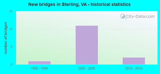
- New bridges - historical statistics
- 11990-1999
- 112000-2009
- 22010-2019


- Bridge Condition - Deck
- 80.0%Good
- 20.0%Satisfactory

- Bridge Condition - Channel
- 33.3%Very good
- 33.3%Good
- 33.3%Satisfactory

- Bridge Condition - Culverts
- 50.0%Good
- 50.0%Satisfactory
Find on map >> Show street view
Structure Number: 26507, Location: 00.45FR775/00.50PAC.Blv (Lat: 39.003244, Lng: -77.435014), Route carried "on" structure: Ramp State highway 28, Year Built: 2005, Status: Open, Structure Length: 30.02m (98.49ft), Average Daily Traffic: 44,269 (year 2018), Truck Traffic: 3%, Average Future Daily Traffic: 9,000 (year 2034), Design Load: HS 20, Features Intersected: RTE. 28 SBL & RTE. 625, Facility Carried by Structure: RAMP H-NB SULLY RD
Minimum Vertical Clearance: 30+ m (98+ ft), Kilometerpoint: 67.996, Lanes on structure: 1, Lanes under structure: 10, Base Highway Network: Yes, Owner: State Highway Agency, Approaching Roadway Width: 9.1m (29.9ft), Material/Design: Concrete continuous, Design/Construction: Stringer/Multi-beam, Number Of Spans In Main Unit: 6, Length of Maximum Span: 59.1m (193.9ft), Curb or Sidewalk Widths: Left: 1.8m (5.9ft), Right: 0.0m, Curb-To-Curb Width: 9.1m (29.9ft), Out-to-Out Width: 10.1m (33.1ft)
Condition: Deck: Satisfactory, Superstructure: Good, Substructure: Good, Operating Rating: 65.0 metric tons, Method Used To Determine Operating Rating: Load and Resistance Factor (LRFR), Inventory Rating: 50.2 metric tons, Method Used To Determine Inventory Rating: Load and Resistance Factor (LRFR), Structural Evaluation: Better than present minimum criteria, Deck Geometry: Superior to present desirable criteria, Underclear: Meets minimum limits, Approach Roadway Alignment: Better than present minimum criteria, Length Of Structure Improvement: 30.02m (98.49ft), Designated Inspection Frequency: Every 24 months, Critical Feature Inspection Frequency: Every 24 months, Inspection Date: August 2021, Critical Feature Inspection Date: August 2021, Bridge Improvement Cost: $55,000, Roadway Improvement Cost: $78,000, Total Project Cost: $150,000, Deck Structure Type: Concrete Cast-file-Place, Wearing Surface/Protective System: Wearing Surface: Monolithic Concrete, Deck Protection: Epoxy Coated Reinforcing
Find on map >> Show street view
Structure Number: 26509, Location: 00.39FR28/00.54TO637 (Lat: 39.005217, Lng: -77.427889), Route carried "on" structure: County highway 625, Year Built: 2006, Status: Open, Structure Length: 1.92m (6.30ft), Average Daily Traffic: 18,866 (year 2020), Truck Traffic: 2%, Average Future Daily Traffic: 26,412 (year 2040), Design Load: HS 20+Mod, Features Intersected: W&OD HIKE & BIKE TRAIL, Facility Carried by Structure: CHURCH ROAD
Minimum Vertical Clearance: 30+ m (98+ ft), Kilometerpoint: 0.000, Lanes on structure: 5, Owner: State Highway Agency, Approaching Roadway Width: 8.5m (27.9ft), Skew: 10 degrees, Material/Design: Prestressed concrete, Design/Construction: Stringer/Multi-beam, Number Of Spans In Main Unit: 1, Length of Maximum Span: 18.6m (61.0ft), Curb or Sidewalk Widths: Left: 3.0m (9.8ft), Right: 3.0m (9.8ft), Curb-To-Curb Width: 21.3m (69.9ft), Out-to-Out Width: 29.0m (95.1ft)
Condition: Deck: Good, Superstructure: Good, Substructure: Good, Operating Rating: 51.0 metric tons, Method Used To Determine Operating Rating: Load and Resistance Factor (LRFR), Inventory Rating: 39.4 metric tons, Method Used To Determine Inventory Rating: Load and Resistance Factor (LRFR), Structural Evaluation: Better than present minimum criteria, Deck Geometry: Somewhat better than minimum adequacy, Approach Roadway Alignment: Better than present minimum criteria, Length Of Structure Improvement: 0.30m (0.98ft), Designated Inspection Frequency: Every 24 months, Inspection Date: Febuary 2022, Bridge Improvement Cost: $1,000, Roadway Improvement Cost: $1,000, Total Project Cost: $3,000, Deck Structure Type: Concrete Cast-file-Place, Wearing Surface/Protective System: Deck Protection: Epoxy Coated Reinforcing
Find on map >> Show street view
Structure Number: 28416, Location: 00.20FR PAC/00.15TO 636 (Lat: 38.989219, Lng: -77.431886), Route carried "on" structure: Alternate County highway 846, Year Built: 2006, Status: Open, Structure Length: 6.71m (22.01ft), Average Daily Traffic: 21,018 (year 2020), Truck Traffic: 5%, Average Future Daily Traffic: 25,543 (year 2040), Design Load: HS 20, Features Intersected: RTE.28 SULLY RD., Facility Carried by Structure: STERLING BLVD.
Minimum Vertical Clearance: 30+ m (98+ ft), Kilometerpoint: 0.016, Lanes on structure: 6, Lanes under structure: 8, Owner: State Highway Agency, Approaching Roadway Width: 11.9m (39.0ft), Skew: 20 degrees, Material/Design: Steel continuous, Design/Construction: Stringer/Multi-beam, Number Of Spans In Main Unit: 2, Length of Maximum Span: 33.2m (108.9ft), Curb or Sidewalk Widths: Left: 3.0m (9.8ft), Right: 3.0m (9.8ft), Curb-To-Curb Width: 29.3m (96.1ft), Out-to-Out Width: 35.8m (117.5ft)
Condition: Deck: Good, Superstructure: Good, Substructure: Good, Operating Rating: 77.0 metric tons, Method Used To Determine Operating Rating: Load and Resistance Factor (LRFR), Inventory Rating: 59.4 metric tons, Method Used To Determine Inventory Rating: Load and Resistance Factor (LRFR), Structural Evaluation: Better than present minimum criteria, Deck Geometry: Superior to present desirable criteria, Underclear: Equal to present minimum criteria, Approach Roadway Alignment: Equal to present desirable criteria, Length Of Structure Improvement: 6.71m (22.01ft), Designated Inspection Frequency: Every 24 months, Inspection Date: November 2020, Bridge Improvement Cost: $99,000, Roadway Improvement Cost: $199,000, Total Project Cost: $400,000 ( Estimate for 2014), Deck Structure Type: Concrete Cast-file-Place, Wearing Surface/Protective System: Wearing Surface: Monolithic Concrete, Deck Protection: Epoxy Coated Reinforcing
Find on map >> Show street view
Structure Number: 28451, Location: 00.25FR PAC/00.08TO636 (Lat: 38.989458, Lng: -77.429819), Route carried "on" structure: County highway 846, Year Built: 2006, Status: Open, Structure Length: 1.22m (4.00ft), Average Daily Traffic: 21,018 (year 2020), Truck Traffic: 5%, Average Future Daily Traffic: 25,543 (year 2040), Design Load: HS 20, Features Intersected: INDIAN CREEK, Facility Carried by Structure: STERLING BLVD.
Minimum Vertical Clearance: 30+ m (98+ ft), Kilometerpoint: 0.161, Lanes on structure: 6, Owner: State Highway Agency, Approaching Roadway Width: 11.0m (36.1ft), Skew: 1 degrees, Material/Design: Concrete, Design/Construction: Culvert, Number Of Spans In Main Unit: 3, Length of Maximum Span: 3.7m (12.1ft)
Condition: Channel: Satisfactory, Culverts: Satisfactory, Operating Rating: 89.8 metric tons, Method Used To Determine Operating Rating: Load Factor (LF), Inventory Rating: 89.8 metric tons, Method Used To Determine Inventory Rating: Load Factor (LF), Structural Evaluation: Equal to present minimum criteria, Waterway Adequacy: Equal to present desirable criteria, Approach Roadway Alignment: Equal to present desirable criteria, Length Of Structure Improvement: 19.66m (64.50ft), Designated Inspection Frequency: Every 24 months, Inspection Date: January 2021, Bridge Improvement Cost: $44,000, Roadway Improvement Cost: $65,000, Total Project Cost: $125,000 ( Estimate for 2015)
Find on map >> Show street view
Structure Number: 28453, Location: 00.02FR 28/00.02TO 846 (Lat: 38.989122, Lng: -77.430597), Route carried "on" structure: Ramp State highway 28, Year Built: 2006, Status: Open, Structure Length: 1.22m (4.00ft), Average Daily Traffic: 2,000 (year 2006), Truck Traffic: 2%, Average Future Daily Traffic: 5,000 (year 2035), Design Load: HS 20, Features Intersected: INDIAN CREEK
Minimum Vertical Clearance: 30+ m (98+ ft), Kilometerpoint: 0.000, Lanes on structure: 1, Base Highway Network: Yes, Owner: State Highway Agency, Approaching Roadway Width: 8.2m (26.9ft), Skew: 2 degrees, Material/Design: Concrete, Design/Construction: Culvert, Number Of Spans In Main Unit: 3, Length of Maximum Span: 4.0m (13.1ft)
Condition: Channel: Good, Culverts: Good, Operating Rating: 89.8 metric tons, Method Used To Determine Operating Rating: Load Factor (LF), Inventory Rating: 89.8 metric tons, Method Used To Determine Inventory Rating: Load Factor (LF), Structural Evaluation: Better than present minimum criteria, Waterway Adequacy: Equal to present desirable criteria, Approach Roadway Alignment: Better than present minimum criteria, Length Of Structure Improvement: 0.61m (2.00ft), Designated Inspection Frequency: Every 24 months, Inspection Date: January 2021, Bridge Improvement Cost: $50,000, Roadway Improvement Cost: $50,000, Total Project Cost: $110,000 ( Estimate for 2015)
Find on map >> Show street view
Structure Number: 29308, Location: 00.29FR0625/00.98TO0847 (Lat: 39.008683, Lng: -77.430506), Route carried "on" structure: County highway 1902, Year Built: 2011, Status: Open, Structure Length: 5.34m (17.52ft), Average Daily Traffic: 1,000 (year 2011), Truck Traffic: 2%, Average Future Daily Traffic: 5,000 (year 2031), Design Load: HS 20, Features Intersected: W&OD Trail & Ruritan Rd, Facility Carried by Structure: Atlantic Blvd
Minimum Vertical Clearance: 30.45m (99.90ft), Kilometerpoint: 0.000, Lanes on structure: 4, Lanes under structure: 2, Owner: State Highway Agency, Approaching Roadway Width: 8.5m (27.9ft), Skew: 13 degrees, Material/Design: Steel, Design/Construction: Stringer/Multi-beam, Number Of Spans In Main Unit: 1, Length of Maximum Span: 52.0m (170.6ft), Curb or Sidewalk Widths: Left: 5.2m (17.1ft), Right: 3.0m (9.8ft), Curb-To-Curb Width: 7.3m (24.0ft), Out-to-Out Width: 30.1m (98.8ft)
Condition: Deck: Good, Superstructure: Good, Substructure: Good, Operating Rating: 89.8 metric tons, Method Used To Determine Operating Rating: Load and Resistance Factor (LRFR), Inventory Rating: 70.6 metric tons, Method Used To Determine Inventory Rating: Load and Resistance Factor (LRFR), Structural Evaluation: Better than present minimum criteria, Deck Geometry: High priority of replacement, Underclear: High priority of corrective action, Approach Roadway Alignment: Better than present minimum criteria, Length Of Structure Improvement: 0.30m (0.98ft), Designated Inspection Frequency: Every 24 months, Inspection Date: March 2020, Total Project Cost: $5,000, Deck Structure Type: Concrete Cast-file-Place, Wearing Surface/Protective System: Wearing Surface: Monolithic Concrete, Deck Protection: Epoxy Coated Reinforcing
Find on map >> Show street view
Structure Number: 30769, Location: 0.22frWarp 0.32to847 (Lat: 39.016850, Lng: -77.428150), Route carried "on" structure: Alternate County highway 1902, Year Built: 1990, Status: Open, Structure Length: 1.28m (4.20ft), Average Daily Traffic: 1,900 (year 2010), Average Future Daily Traffic: 3,116 (year 2042), Design Load: HS 20, Features Intersected: CABIN BRANCH, Facility Carried by Structure: ATLANTIC BLVD.
Minimum Vertical Clearance: 30.18m (99.02ft), Kilometerpoint: 0.000, Lanes on structure: 4, Owner: State Highway Agency, Approaching Roadway Width: 8.2m (26.9ft), Skew: 20 degrees, Material/Design: Concrete, Design/Construction: Arch - Deck, Number Of Spans In Main Unit: 1, Length of Maximum Span: 12.2m (40.0ft), Curb-To-Curb Width: 7.3m (24.0ft), Out-to-Out Width: 31.7m (104.0ft)
Condition: Deck: Good, Superstructure: Good, Substructure: Good, Channel: Very good, Operating Rating: 44.5 metric tons, Method Used To Determine Operating Rating: Field evaluation and documented engineering judgment, Inventory Rating: 32.7 metric tons, Method Used To Determine Inventory Rating: Field evaluation and documented engineering judgment, Structural Evaluation: Better than present minimum criteria, Deck Geometry: High priority of replacement, Waterway Adequacy: Better than present minimum criteria, Approach Roadway Alignment: Equal to present minimum criteria, Designated Inspection Frequency: Every 24 months, Inspection Date: December 2020, Deck Structure Type: Concrete Precast Panels, Wearing Surface/Protective System: Wearing Surface: Bituminous, Deck Protection: Epoxy Coated Reinforcing
Find on map >> Show street view
Structure Number: 26507, Location: 00.45FR775/00.50PAC.Blv (Lat: 39.003244, Lng: -77.435014), Route carried "under" structure: Alternate County highway 625, Year Built: 2005, Structure Length: 0. m, Average Daily Traffic: 12,000 (year 2008), Truck Traffic: 2%, Features Intersected: RTE. 28 SBL & RTE. 625, Facility Carried by Structure: RAMP H-NB SULLY RD
Minimum Vertical Clearance: 5.21m (17.09ft), Kilometerpoint: 0.000, Lanes on structure: 1, Lanes under structure: 3, Material/Design: Concrete continuous, Design/Construction: Stringer/Multi-beam, Length of Maximum Span: 59.1m (193.9ft)
Find on map >> Show street view
Structure Number: 26507, Location: 00.45FR775/00.50PAC.Blv (Lat: 39.003244, Lng: -77.435014), Route carried "under" structure: Alternate County highway 625, Year Built: 2005, Structure Length: 0. m, Average Daily Traffic: 8,000 (year 2008), Truck Traffic: 2%, Features Intersected: RTE. 28 SBL & RTE. 625, Facility Carried by Structure: RAMP H-NB SULLY RD
Minimum Vertical Clearance: 5.49m (18.01ft), Kilometerpoint: 0.000, Lanes on structure: 1, Lanes under structure: 2, Material/Design: Concrete continuous, Design/Construction: Stringer/Multi-beam, Length of Maximum Span: 59.1m (193.9ft)
Find on map >> Show street view
Structure Number: 26507, Location: 00.45FR775/00.50PAC.Blv (Lat: 39.003244, Lng: -77.435014), Route carried "under" structure: State highway 28, Year Built: 2005, Structure Length: 0. m, Average Daily Traffic: 56,550 (year 2008), Truck Traffic: 5%, Features Intersected: RTE. 28 SBL & RTE. 625, Facility Carried by Structure: RAMP H-NB SULLY RD
Minimum Vertical Clearance: 6.78m (22.24ft), Kilometerpoint: 0.000, Lanes on structure: 1, Lanes under structure: 3, Material/Design: Concrete continuous, Design/Construction: Stringer/Multi-beam, Length of Maximum Span: 59.1m (193.9ft)
Find on map >> Show street view
Structure Number: 26507, Location: 00.45FR775/00.50PAC.Blv (Lat: 39.003244, Lng: -77.435014), Route carried "under" structure: Ramp State highway 28, Year Built: 2005, Structure Length: 0. m, Average Daily Traffic: 15,000 (year 2008), Truck Traffic: 2%, Features Intersected: RTE. 28 SBL & RTE. 625, Facility Carried by Structure: RAMP H-NB SULLY RD
Minimum Vertical Clearance: 9.22m (30.25ft), Kilometerpoint: 0.000, Lanes on structure: 1, Lanes under structure: 2, Material/Design: Concrete continuous, Design/Construction: Stringer/Multi-beam, Length of Maximum Span: 59.1m (193.9ft)
Find on map >> Show street view
Structure Number: 28416, Location: 00.20FR PAC/00.15TO 636 (Lat: 38.989219, Lng: -77.431886), Route carried "under" structure: State highway 28, Year Built: 2006, Structure Length: 0. m, Average Daily Traffic: 50,000 (year 2009), Truck Traffic: 5%, Features Intersected: RTE.28 SULLY RD., Facility Carried by Structure: STERLING BLVD.
Minimum Vertical Clearance: 5.46m (17.91ft), Kilometerpoint: 0.000, Lanes on structure: 6, Lanes under structure: 4, Material/Design: Steel continuous, Design/Construction: Stringer/Multi-beam, Length of Maximum Span: 33.2m (108.9ft)
Find on map >> Show street view
Structure Number: 28416, Location: 00.20FR PAC/00.15TO 636 (Lat: 38.989219, Lng: -77.431886), Route carried "under" structure: State highway 28, Year Built: 2006, Structure Length: 0. m, Average Daily Traffic: 50,000 (year 2009), Truck Traffic: 5%, Features Intersected: RTE.28 SULLY RD., Facility Carried by Structure: STERLING BLVD.
Minimum Vertical Clearance: 5.74m (18.83ft), Kilometerpoint: 0.000, Lanes on structure: 6, Lanes under structure: 4, Material/Design: Steel continuous, Design/Construction: Stringer/Multi-beam, Length of Maximum Span: 33.2m (108.9ft)
Find on map >> Show street view
Structure Number: 29308, Location: 00.29FR0625/00.98TO0847 (Lat: 39.008683, Lng: -77.430506), Route carried "under" structure: County highway 610, Year Built: 2011, Structure Length: 0. m, Average Daily Traffic: 200 (year 2011), Features Intersected: W&OD Trail & Ruritan Rd, Facility Carried by Structure: Atlantic Blvd
Minimum Vertical Clearance: 5.03m (16.50ft), Kilometerpoint: 0.000, Lanes on structure: 4, Lanes under structure: 2, Material/Design: Steel, Design/Construction: Stringer/Multi-beam, Length of Maximum Span: 52.0m (170.6ft)