Bridge Statistics for Sugar Land, Texas (TX)
Condition, Traffic, Stress, Structural Evaluation, Project Costs
- National Bridge Inventory (NBI) Statistics
- 155Number of bridges
- 4,055ft / 1,236mTotal length
- $1,135,000Total costs
- 2,765,982Total average daily traffic
- 180,152Total average daily truck traffic
- National Bridge Inventory (NBI) Registered Bridges for Sugar Land
- No street view available for this location
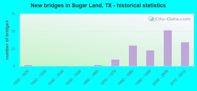
- New bridges - historical statistics
- 21920-1929
- 11940-1949
- 21960-1969
- 101970-1979
- 301980-1989
- 231990-1999
- 522000-2009
- 352010-2019
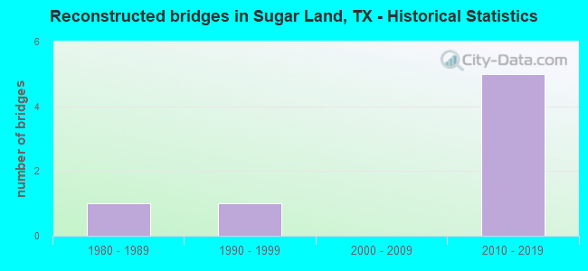
- Reconstructed bridges - Historical Statistics
- 11980-1989
- 11990-1999
- 02000-2009
- 52010-2019
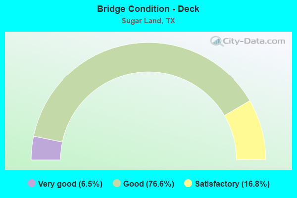
- Bridge Condition - Deck
- 6.5%Very good
- 76.6%Good
- 16.8%Satisfactory
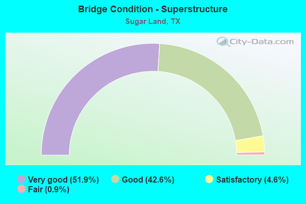
- Bridge Condition - Superstructure
- 51.9%Very good
- 42.6%Good
- 4.6%Satisfactory
- 0.9%Fair
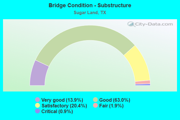
- Bridge Condition - Substructure
- 13.9%Very good
- 63.0%Good
- 20.4%Satisfactory
- 1.9%Fair
- 0.9%Critical
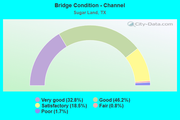
- Bridge Condition - Channel
- 32.8%Very good
- 46.2%Good
- 18.5%Satisfactory
- 0.8%Fair
- 1.7%Poor
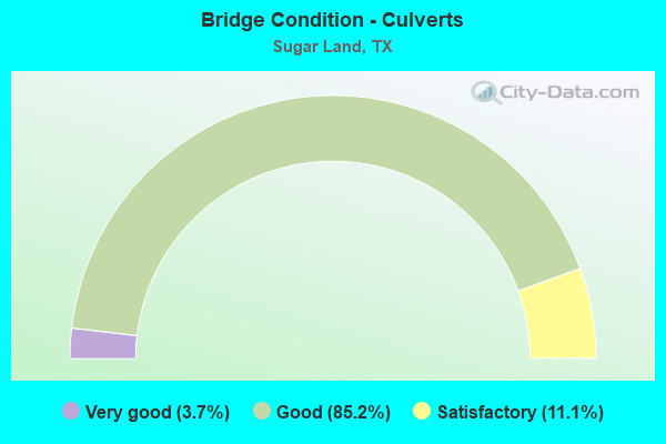
- Bridge Condition - Culverts
- 3.7%Very good
- 85.2%Good
- 11.1%Satisfactory
Find on map >> Show street view
Structure Number: 120800002708017, Location: 0.25 MI E OF SH 6 (Lat: 29.615303, Lng: -95.645147), Route carried "on" structure: Alternate US 90, Year Built: 2007, Status: Open, Structure Length: 2.99m (9.81ft), Average Daily Traffic: 21,340 (year 2013), Truck Traffic: 3%, Average Future Daily Traffic: 29,880 (year 2033), Design Load: HS 20, Features Intersected: Ditch H
Minimum Vertical Clearance: 30+ m (98+ ft), Kilometerpoint: 41.476, Lanes on structure: 9, Owner: State Highway Agency, Approaching Roadway Width: 34.7m (113.8ft), Skew: 24 degrees, Material/Design: Concrete, Design/Construction: Culvert, Number Of Spans In Main Unit: 6, Length of Maximum Span: 3.0m (9.8ft)
Condition: Channel: Very good, Culverts: Good, Operating Rating: 54.4 metric tons, Method Used To Determine Operating Rating: Assigned rating based on Load Factor Design (LFD) reported in metric tons, Inventory Rating: 32.7 metric tons, Method Used To Determine Inventory Rating: Assigned rating based on Load Factor Design (LFD) reported in metric tons, Structural Evaluation: Better than present minimum criteria, Waterway Adequacy: Equal to present minimum criteria, Approach Roadway Alignment: Equal to present desirable criteria, Designated Inspection Frequency: Every 48 months, Inspection Date: December 2020
Find on map >> Show street view
Structure Number: 120800002708018, Location: 0.15 MI E OF SH 6 (Lat: 29.614625, Lng: -95.646442), Route carried "on" structure: Alternate US 90, Year Built: 2007, Status: Open, Structure Length: 1.22m (4.00ft), Average Daily Traffic: 21,340 (year 2013), Truck Traffic: 3%, Average Future Daily Traffic: 29,880 (year 2033), Design Load: HS 20, Features Intersected: Drainage Ditch
Minimum Vertical Clearance: 30+ m (98+ ft), Kilometerpoint: 41.610, Lanes on structure: 9, Owner: State Highway Agency, Approaching Roadway Width: 34.7m (113.8ft), Skew: 20 degrees, Material/Design: Concrete, Design/Construction: Culvert, Number Of Spans In Main Unit: 6, Length of Maximum Span: 1.5m (4.9ft)
Condition: Channel: Very good, Culverts: Good, Operating Rating: 54.4 metric tons, Method Used To Determine Operating Rating: Assigned rating based on Load Factor Design (LFD) reported in metric tons, Inventory Rating: 32.7 metric tons, Method Used To Determine Inventory Rating: Assigned rating based on Load Factor Design (LFD) reported in metric tons, Structural Evaluation: Better than present minimum criteria, Waterway Adequacy: Equal to present minimum criteria, Approach Roadway Alignment: Equal to present desirable criteria, Designated Inspection Frequency: Every 48 months, Inspection Date: December 2020
Find on map >> Show street view
Structure Number: 12080000270802, Location: 1.05 MI E OF SH 6 (Lat: 29.620322, Lng: -95.633939), Route carried "on" structure: Alternate State highway 90, Year Built: 2008, Status: Open, Structure Length: 6.40m (21.00ft), Average Daily Traffic: 14,000 (year 2012), Truck Traffic: 4%, Average Future Daily Traffic: 31,580 (year 2032), Design Load: HS 20, Features Intersected: OYSTER CREEK
Minimum Vertical Clearance: 30+ m (98+ ft), Kilometerpoint: 43.296, Lanes on structure: 9, Owner: State Highway Agency, Approaching Roadway Width: 31.1m (102.0ft), Skew: 20 degrees, Material/Design: Prestressed concrete, Design/Construction: Box Beam or Girders - Multiple, Number Of Spans In Main Unit: 7, Length of Maximum Span: 9.1m (29.9ft), Curb or Sidewalk Widths: Left: 1.8m (5.9ft), Right: 1.8m (5.9ft), Curb-To-Curb Width: 37.2m (122.0ft), Out-to-Out Width: 48.2m (158.1ft)
Condition: Deck: Good, Superstructure: Very good, Substructure: Good, Channel: Good, Operating Rating: 54.4 metric tons, Method Used To Determine Operating Rating: Assigned rating based on Load Factor Design (LFD) reported in metric tons, Inventory Rating: 32.7 metric tons, Method Used To Determine Inventory Rating: Assigned rating based on Load Factor Design (LFD) reported in metric tons, Structural Evaluation: Better than present minimum criteria, Deck Geometry: Equal to present minimum criteria, Waterway Adequacy: Superior to present desirable criteria, Approach Roadway Alignment: Equal to present desirable criteria, Designated Inspection Frequency: Every 24 months, Inspection Date: December 2020, Deck Structure Type: Concrete Cast-file-Place, Wearing Surface/Protective System: Wearing Surface: Monolithic Concrete
Find on map >> Show street view
Structure Number: 120800002708027, Location: 0.95 MI W OF SH 6 (Lat: 29.607164, Lng: -95.663847), Route carried "on" structure: Alternate US 90, Year Built: 1925, Year Reconstructed: 2016, Status: Open, Structure Length: 3.08m (10.10ft), Average Daily Traffic: 27,544 (year 2019), Truck Traffic: 2%, Average Future Daily Traffic: 33,053 (year 2039), Design Load: H 15, Features Intersected: BULLHEAD BAYOU
Minimum Vertical Clearance: 30+ m (98+ ft), Kilometerpoint: 40.063, Lanes on structure: 4, Owner: State Highway Agency, Approaching Roadway Width: 18.3m (60.0ft), Material/Design: Concrete, Design/Construction: Slab, Number Of Spans In Main Unit: 5, Length of Maximum Span: 6.1m (20.0ft), Curb-To-Curb Width: 18.1m (59.4ft), Out-to-Out Width: 18.8m (61.7ft)
Condition: Deck: Good, Superstructure: Good, Substructure: Good, Channel: Very good, Operating Rating: 42.6 metric tons, Method Used To Determine Operating Rating: Load Factor (LF), Inventory Rating: 25.4 metric tons, Method Used To Determine Inventory Rating: Load Factor (LF), Structural Evaluation: Equal to present minimum criteria, Deck Geometry: Meets minimum limits, Waterway Adequacy: Equal to present minimum criteria, Approach Roadway Alignment: Equal to present desirable criteria, Length Of Structure Improvement: 3.05m (10.01ft), Designated Inspection Frequency: Every 24 months, Inspection Date: October 2020, Bridge Improvement Cost: $6,000, Roadway Improvement Cost: $2,000, Total Project Cost: $8,000, Deck Structure Type: Concrete Cast-file-Place, Wearing Surface/Protective System: Wearing Surface: Bituminous
Find on map >> Show street view
Structure Number: 120800002708028, Location: 0.20 MI SW OF SH 6 (Lat: 29.612322, Lng: -95.652192), Route carried "on" structure: Alternate US 90, Year Built: 1925, Year Reconstructed: 2017, Status: Open, Structure Length: 1.86m (6.10ft), Average Daily Traffic: 10,670 (year 2013), Truck Traffic: 3%, Average Future Daily Traffic: 14,940 (year 2033), Design Load: H 15, Features Intersected: PRISON FARM RD (RELIEF)
Minimum Vertical Clearance: 30+ m (98+ ft), Kilometerpoint: 41.289, Lanes on structure: 3, Owner: State Highway Agency, Approaching Roadway Width: 15.2m (49.9ft), Material/Design: Concrete, Design/Construction: Slab, Number Of Spans In Main Unit: 3, Length of Maximum Span: 6.1m (20.0ft), Curb-To-Curb Width: 14.4m (47.2ft), Out-to-Out Width: 15.5m (50.9ft)
Condition: Deck: Good, Superstructure: Good, Substructure: Satisfactory, Channel: Good, Operating Rating: 43.5 metric tons, Method Used To Determine Operating Rating: Load Factor (LF), Inventory Rating: 25.4 metric tons, Method Used To Determine Inventory Rating: Load Factor (LF), Structural Evaluation: Equal to present minimum criteria, Deck Geometry: Meets minimum limits, Waterway Adequacy: Superior to present desirable criteria, Approach Roadway Alignment: Equal to present desirable criteria, Length Of Structure Improvement: 1.86m (6.10ft), Designated Inspection Frequency: Every 24 months, Inspection Date: December 2020, Bridge Improvement Cost: $4,000, Roadway Improvement Cost: $1,000, Total Project Cost: $5,000, Deck Structure Type: Concrete Cast-file-Place, Wearing Surface/Protective System: Wearing Surface: Bituminous
Find on map >> Show street view
Structure Number: 120800002708058, Location: 0.20 MI SW OF SH 6 (Lat: 29.612147, Lng: -95.652047), Route carried "on" structure: Alternate US 90, Year Built: 1942, Year Reconstructed: 2017, Status: Open, Structure Length: 1.83m (6.00ft), Average Daily Traffic: 10,670 (year 2013), Truck Traffic: 3%, Average Future Daily Traffic: 14,940 (year 2033), Design Load: H 20, Features Intersected: PRISON FARM RD (RELIEF)
Minimum Vertical Clearance: 30+ m (98+ ft), Kilometerpoint: 41.289, Lanes on structure: 3, Owner: State Highway Agency, Approaching Roadway Width: 15.2m (49.9ft), Material/Design: Concrete, Design/Construction: Slab, Number Of Spans In Main Unit: 3, Length of Maximum Span: 6.1m (20.0ft), Curb-To-Curb Width: 14.4m (47.2ft), Out-to-Out Width: 15.4m (50.5ft)
Condition: Deck: Good, Superstructure: Satisfactory, Substructure: Good, Channel: Very good, Operating Rating: 42.6 metric tons, Method Used To Determine Operating Rating: Load Factor (LF), Inventory Rating: 25.4 metric tons, Method Used To Determine Inventory Rating: Load Factor (LF), Structural Evaluation: Equal to present minimum criteria, Deck Geometry: Meets minimum limits, Waterway Adequacy: Superior to present desirable criteria, Approach Roadway Alignment: Equal to present desirable criteria, Length Of Structure Improvement: 1.74m (5.71ft), Designated Inspection Frequency: Every 24 months, Inspection Date: December 2020, Bridge Improvement Cost: $3,000, Roadway Improvement Cost: $1,000, Total Project Cost: $4,000, Deck Structure Type: Concrete Cast-file-Place, Wearing Surface/Protective System: Wearing Surface: Bituminous
Find on map >> Show street view
Structure Number: 12080000271205, Location: 1.3 Mi SW of Brazos River (Lat: 29.560939, Lng: -95.691253), Route carried "on" structure: US 59, Year Built: 2007, Status: Open, Structure Length: 23.62m (77.49ft), Average Daily Traffic: 15,336 (year 2019), Truck Traffic: 9%, Average Future Daily Traffic: 94,650 (year 2031), Design Load: HS 25 or greater, Features Intersected: SH 99 & Drain
Minimum Vertical Clearance: 30+ m (98+ ft), Kilometerpoint: 15.226, Lanes on structure: 6, Lanes under structure: 12, Owner: State Highway Agency, Approaching Roadway Width: 31.1m (102.0ft), Skew: 4 degrees, Material/Design: Steel, Design/Construction: Box Beam or Girders - Multiple, Number Of Spans In Main Unit: 2, Number Of Approach Spans: 4, Length of Maximum Span: 44.2m (145.0ft), Curb-To-Curb Width: 31.1m (102.0ft), Out-to-Out Width: 31.7m (104.0ft)
Condition: Deck: Good, Superstructure: Good, Substructure: Good, Channel: Very good, Operating Rating: 54.4 metric tons, Method Used To Determine Operating Rating: Assigned rating based on Load Factor Design (LFD) reported in metric tons, Inventory Rating: 32.7 metric tons, Method Used To Determine Inventory Rating: Assigned rating based on Load Factor Design (LFD) reported in metric tons, Structural Evaluation: Better than present minimum criteria, Deck Geometry: Superior to present desirable criteria, Underclear: Meets minimum limits, Waterway Adequacy: Superior to present desirable criteria, Approach Roadway Alignment: Equal to present desirable criteria, Designated Inspection Frequency: Every 24 months, Inspection Date: December 2020, Deck Structure Type: Concrete Cast-file-Place
Find on map >> Show street view
Structure Number: 120800002712061, Location: 1.3 Mi SW of Brazos River (Lat: 29.562017, Lng: -95.688600), Route carried "on" structure: US 59, Year Built: 2007, Status: Open, Structure Length: 23.50m (77.10ft), Average Daily Traffic: 16,033 (year 2019), Truck Traffic: 9%, Average Future Daily Traffic: 94,650 (year 2031), Design Load: HS 25 or greater, Features Intersected: SH 99 & Drain
Minimum Vertical Clearance: 30+ m (98+ ft), Kilometerpoint: 15.208, Lanes on structure: 5, Lanes under structure: 12, Owner: State Highway Agency, Approaching Roadway Width: 31.1m (102.0ft), Skew: 4 degrees, Material/Design: Steel, Design/Construction: Box Beam or Girders - Multiple, Number Of Spans In Main Unit: 2, Number Of Approach Spans: 4, Length of Maximum Span: 44.2m (145.0ft), Curb-To-Curb Width: 21.9m (71.9ft), Out-to-Out Width: 31.7m (104.0ft)
Condition: Deck: Good, Superstructure: Good, Substructure: Good, Channel: Very good, Operating Rating: 54.4 metric tons, Method Used To Determine Operating Rating: Assigned rating based on Load Factor Design (LFD) reported in metric tons, Inventory Rating: 32.7 metric tons, Method Used To Determine Inventory Rating: Assigned rating based on Load Factor Design (LFD) reported in metric tons, Structural Evaluation: Better than present minimum criteria, Deck Geometry: Meets minimum limits, Underclear: Meets minimum limits, Waterway Adequacy: Superior to present desirable criteria, Approach Roadway Alignment: Equal to present desirable criteria, Designated Inspection Frequency: Every 24 months, Inspection Date: December 2020, Deck Structure Type: Concrete Cast-file-Place
Find on map >> Show street view
Structure Number: 120800002712127, Location: 0.60 MI SW OF US 90A (Lat: 29.621661, Lng: -95.600478), Route carried "on" structure: Interstate 69, Year Built: 1970, Status: Open, Structure Length: 0.85m (2.79ft), Average Daily Traffic: 183,561 (year 2020), Truck Traffic: 7%, Average Future Daily Traffic: 240,240 (year 2031), Design Load: HS 20, Features Intersected: Storm Sewer Lateral
Minimum Vertical Clearance: 30+ m (98+ ft), Kilometerpoint: 4.080, Lanes on structure: 18, Base Highway Network: Yes, Owner: State Highway Agency, Approaching Roadway Width: 74.4m (244.1ft), Skew: 24 degrees, Material/Design: Concrete, Design/Construction: Culvert, Number Of Spans In Main Unit: 2, Length of Maximum Span: 3.0m (9.8ft)
Condition: Channel: Good, Culverts: Satisfactory, Operating Rating: 39.9 metric tons, Method Used To Determine Operating Rating: Load Factor (LF), Inventory Rating: 23.6 metric tons, Method Used To Determine Inventory Rating: Load Factor (LF), Structural Evaluation: Somewhat better than minimum adequacy, Waterway Adequacy: Equal to present minimum criteria, Approach Roadway Alignment: Equal to present desirable criteria, Designated Inspection Frequency: Every 24 months, Inspection Date: December 2020
Find on map >> Show street view
Structure Number: 120800002712131, Location: 0.95 MI E OF FM 2759 (Lat: 29.564286, Lng: -95.676047), Route carried "on" structure: US 59, Year Built: 1971, Status: Open, Structure Length: 0.79m (2.59ft), Average Daily Traffic: 94,650 (year 2011), Truck Traffic: 9%, Average Future Daily Traffic: 189,300 (year 2031), Design Load: HS 20, Features Intersected: Middle Bayou Tributary
Minimum Vertical Clearance: 30+ m (98+ ft), Kilometerpoint: 13.893, Lanes on structure: 16, Owner: State Highway Agency, Approaching Roadway Width: 71.3m (233.9ft), Skew: 30 degrees, Material/Design: Concrete, Design/Construction: Culvert, Number Of Spans In Main Unit: 3, Length of Maximum Span: 2.4m (7.9ft)
Condition: Channel: Very good, Culverts: Good, Operating Rating: 39.9 metric tons, Method Used To Determine Operating Rating: Load Factor (LF), Inventory Rating: 23.6 metric tons, Method Used To Determine Inventory Rating: Load Factor (LF), Structural Evaluation: Somewhat better than minimum adequacy, Waterway Adequacy: Equal to present minimum criteria, Approach Roadway Alignment: Equal to present desirable criteria, Designated Inspection Frequency: Every 24 months, Inspection Date: December 2020
Find on map >> Show street view
Structure Number: 120800002712135, Location: 2.00 MI SW OF SH 6 (Lat: 29.580231, Lng: -95.649069), Route carried "on" structure: US 59, Year Built: 1971, Status: Open, Structure Length: 0.67m (2.20ft), Average Daily Traffic: 27,291 (year 2020), Truck Traffic: 9%, Average Future Daily Traffic: 94,650 (year 2031), Design Load: HS 20, Features Intersected: Alcorn Bayou
Minimum Vertical Clearance: 30+ m (98+ ft), Kilometerpoint: 10.783, Lanes on structure: 4, Owner: State Highway Agency, Approaching Roadway Width: 24.4m (80.1ft), Skew: 20 degrees, Material/Design: Concrete, Design/Construction: Culvert, Number Of Spans In Main Unit: 2, Length of Maximum Span: 3.0m (9.8ft)
Condition: Channel: Satisfactory, Culverts: Good, Operating Rating: 39.9 metric tons, Method Used To Determine Operating Rating: Load Factor (LF), Inventory Rating: 23.6 metric tons, Method Used To Determine Inventory Rating: Load Factor (LF), Structural Evaluation: Somewhat better than minimum adequacy, Waterway Adequacy: Equal to present minimum criteria, Approach Roadway Alignment: Equal to present desirable criteria, Designated Inspection Frequency: Every 24 months, Inspection Date: September 2020
Find on map >> Show street view
Structure Number: 120800002712145, Location: 0.30 MI NE OF SH 6 (Lat: 29.601517, Lng: -95.618983), Route carried "on" structure: Interstate 69, Year Built: 1971, Year Reconstructed: 2002, Status: Open, Structure Length: 7.32m (24.02ft), Average Daily Traffic: 180,252 (year 2019), Truck Traffic: 8%, Average Future Daily Traffic: 252,353 (year 2039), Design Load: HS 20, Features Intersected: OYSTER CREEK
Minimum Vertical Clearance: 30+ m (98+ ft), Kilometerpoint: 6.954, Lanes on structure: 10, Owner: State Highway Agency, Approaching Roadway Width: 49.4m (162.1ft), Material/Design: Concrete, Design/Construction: Stringer/Multi-beam, Number Of Spans In Main Unit: 6, Length of Maximum Span: 12.2m (40.0ft), Curb-To-Curb Width: 49.3m (161.7ft), Out-to-Out Width: 50.8m (166.7ft)
Condition: Deck: Good, Superstructure: Good, Substructure: Fair, Channel: Very good, Operating Rating: 54.4 metric tons, Method Used To Determine Operating Rating: Load Factor (LF), Inventory Rating: 32.7 metric tons, Method Used To Determine Inventory Rating: Load Factor (LF), Structural Evaluation: Somewhat better than minimum adequacy, Deck Geometry: Superior to present desirable criteria, Waterway Adequacy: Superior to present desirable criteria, Approach Roadway Alignment: Equal to present desirable criteria, Designated Inspection Frequency: Every 24 months, Inspection Date: November 2020, Deck Structure Type: Concrete Cast-file-Place
Find on map >> Show street view
Structure Number: 120800002712299, Location: 4.95 MI NE OF SH 99 (Lat: 29.597933, Lng: -95.622422), Route carried "on" structure: Interstate 69, Year Built: 2002, Status: Open, Structure Length: 9.97m (32.71ft), Average Daily Traffic: 156,030 (year 2011), Truck Traffic: 7%, Average Future Daily Traffic: 240,320 (year 2031), Design Load: HS 20, Features Intersected: SH 6
Minimum Vertical Clearance: 30+ m (98+ ft), Kilometerpoint: 7.474, Lanes on structure: 12, Lanes under structure: 12, Owner: State Highway Agency, Approaching Roadway Width: 56.1m (184.1ft), Skew: 31 degrees, Material/Design: Prestressed concrete, Design/Construction: Stringer/Multi-beam, Number Of Spans In Main Unit: 4, Length of Maximum Span: 25.0m (82.0ft), Curb-To-Curb Width: 56.1m (184.1ft), Out-to-Out Width: 57.4m (188.3ft)
Condition: Deck: Good, Superstructure: Good, Substructure: Good, Operating Rating: 54.4 metric tons, Method Used To Determine Operating Rating: Assigned rating based on Load Factor Design (LFD) reported in metric tons, Inventory Rating: 32.7 metric tons, Method Used To Determine Inventory Rating: Assigned rating based on Load Factor Design (LFD) reported in metric tons, Structural Evaluation: Better than present minimum criteria, Deck Geometry: Superior to present desirable criteria, Underclear: High priority of corrective action, Approach Roadway Alignment: Equal to present desirable criteria, Designated Inspection Frequency: Every 24 months, Inspection Date: September 2020, Deck Structure Type: Concrete Precast Panels
Find on map >> Show street view
Structure Number: 1208000027123, Location: 0.30 MI NE OF SH 6 (Lat: 29.601881, Lng: -95.619353), Route carried "on" structure: ServiceInterstate 69, Year Built: 2001, Status: Open, Structure Length: 7.92m (25.98ft), Average Daily Traffic: 11,900 (year 2012), Truck Traffic: 10%, Average Future Daily Traffic: 20,150 (year 2032), Design Load: HS 20, Features Intersected: OYSTER CREEK
Minimum Vertical Clearance: 30+ m (98+ ft), Kilometerpoint: 6.954, Lanes on structure: 3, Owner: State Highway Agency, Approaching Roadway Width: 15.2m (49.9ft), Skew: 1 degrees, Material/Design: Prestressed concrete, Design/Construction: Box Beam or Girders - Multiple, Number Of Spans In Main Unit: 6, Length of Maximum Span: 15.2m (49.9ft), Curb or Sidewalk Widths: Left: 1.8m (5.9ft), Right: 0.0m, Curb-To-Curb Width: 15.1m (49.5ft), Out-to-Out Width: 18.0m (59.1ft)
Condition: Deck: Good, Superstructure: Good, Substructure: Good, Channel: Satisfactory, Operating Rating: 54.4 metric tons, Method Used To Determine Operating Rating: Assigned rating based on Load Factor Design (LFD) reported in metric tons, Inventory Rating: 32.7 metric tons, Method Used To Determine Inventory Rating: Assigned rating based on Load Factor Design (LFD) reported in metric tons, Structural Evaluation: Better than present minimum criteria, Deck Geometry: Meets minimum limits, Waterway Adequacy: Superior to present desirable criteria, Approach Roadway Alignment: Equal to present desirable criteria, Designated Inspection Frequency: Every 24 months, Inspection Date: November 2020, Deck Structure Type: Concrete Cast-file-Place
Find on map >> Show street view
Structure Number: 120800002712301, Location: 0.30 MI NE OF SH 6 (Lat: 29.601397, Lng: -95.618725), Route carried "on" structure: ServiceInterstate 69, Year Built: 2001, Status: Open, Structure Length: 7.62m (25.00ft), Average Daily Traffic: 11,900 (year 2012), Truck Traffic: 10%, Average Future Daily Traffic: 20,150 (year 2032), Design Load: HS 20, Features Intersected: OYSTER CREEK
Minimum Vertical Clearance: 30+ m (98+ ft), Kilometerpoint: 6.954, Lanes on structure: 4, Owner: State Highway Agency, Approaching Roadway Width: 15.2m (49.9ft), Material/Design: Prestressed concrete, Design/Construction: Box Beam or Girders - Multiple, Number Of Spans In Main Unit: 6, Length of Maximum Span: 15.2m (49.9ft), Curb or Sidewalk Widths: Left: 0.0m, Right: 1.8m (5.9ft), Curb-To-Curb Width: 15.0m (49.2ft), Out-to-Out Width: 18.0m (59.1ft)
Condition: Deck: Good, Superstructure: Very good, Substructure: Good, Channel: Very good, Operating Rating: 54.4 metric tons, Method Used To Determine Operating Rating: Assigned rating based on Load Factor Design (LFD) reported in metric tons, Inventory Rating: 32.7 metric tons, Method Used To Determine Inventory Rating: Assigned rating based on Load Factor Design (LFD) reported in metric tons, Structural Evaluation: Better than present minimum criteria, Deck Geometry: High priority of replacement, Waterway Adequacy: Superior to present desirable criteria, Approach Roadway Alignment: Equal to present desirable criteria, Length Of Structure Improvement: 7.62m (25.00ft), Designated Inspection Frequency: Every 24 months, Inspection Date: November 2020, Bridge Improvement Cost: $25,000, Roadway Improvement Cost: $6,000, Total Project Cost: $31,000, Deck Structure Type: Concrete Cast-file-Place
Find on map >> Show street view
Structure Number: 120800002712302, Location: 0.80 MI NE OF SH 6 (Lat: 29.607497, Lng: -95.613547), Route carried "on" structure: Interstate 69, Year Built: 2002, Status: Open, Structure Length: 9.45m (31.00ft), Average Daily Traffic: 156,030 (year 2011), Truck Traffic: 7%, Average Future Daily Traffic: 240,320 (year 2031), Design Load: HS 20, Features Intersected: Williams Trace Blvd
Minimum Vertical Clearance: 30+ m (98+ ft), Kilometerpoint: 6.188, Lanes on structure: 12, Lanes under structure: 8, Owner: State Highway Agency, Approaching Roadway Width: 56.1m (184.1ft), Skew: 30 degrees, Material/Design: Prestressed concrete, Design/Construction: Stringer/Multi-beam, Number Of Spans In Main Unit: 3, Length of Maximum Span: 36.6m (120.1ft), Curb-To-Curb Width: 56.1m (184.1ft), Out-to-Out Width: 57.4m (188.3ft)
Condition: Deck: Good, Superstructure: Good, Substructure: Good, Operating Rating: 54.4 metric tons, Method Used To Determine Operating Rating: Assigned rating based on Load Factor Design (LFD) reported in metric tons, Inventory Rating: 32.7 metric tons, Method Used To Determine Inventory Rating: Assigned rating based on Load Factor Design (LFD) reported in metric tons, Structural Evaluation: Better than present minimum criteria, Deck Geometry: Superior to present desirable criteria, Underclear: Superior to present desirable criteria, Approach Roadway Alignment: Equal to present desirable criteria, Designated Inspection Frequency: Every 24 months, Inspection Date: September 2020, Deck Structure Type: Concrete Precast Panels
Find on map >> Show street view
Structure Number: 120800002712309, Location: 2.0 Mi NE of SH 6 (Lat: 29.621317, Lng: -95.601503), Route carried "on" structure: Interstate 69, Year Built: 2004, Status: Open, Structure Length: 10.00m (32.81ft), Average Daily Traffic: 183,561 (year 2020), Truck Traffic: 7%, Average Future Daily Traffic: 240,240 (year 2031), Design Load: HS 20, Features Intersected: SP 41 (Sugar Creek Blvd)
Minimum Vertical Clearance: 30+ m (98+ ft), Kilometerpoint: 4.186, Lanes on structure: 10, Lanes under structure: 8, Base Highway Network: Yes, Owner: State Highway Agency, Approaching Roadway Width: 50.6m (166.0ft), Material/Design: Prestressed concrete, Design/Construction: Stringer/Multi-beam, Number Of Spans In Main Unit: 3, Length of Maximum Span: 37.8m (124.0ft), Curb-To-Curb Width: 50.7m (166.3ft), Out-to-Out Width: 51.9m (170.3ft)
Condition: Deck: Good, Superstructure: Good, Substructure: Good, Operating Rating: 54.4 metric tons, Method Used To Determine Operating Rating: Assigned rating based on Load Factor Design (LFD) reported in metric tons, Inventory Rating: 32.7 metric tons, Method Used To Determine Inventory Rating: Assigned rating based on Load Factor Design (LFD) reported in metric tons, Structural Evaluation: Better than present minimum criteria, Deck Geometry: Superior to present desirable criteria, Underclear: Equal to present minimum criteria, Approach Roadway Alignment: Equal to present desirable criteria, Designated Inspection Frequency: Every 24 months, Inspection Date: December 2020, Deck Structure Type: Concrete Precast Panels
Find on map >> Show street view
Structure Number: 12080000271231, Location: 2.0 Mi NE of SH 6 (Lat: 29.621475, Lng: -95.602203), Route carried "on" structure: Ramp Interstate 69, Year Built: 2008, Status: Open, Structure Length: 62.45m (204.89ft), Average Daily Traffic: 5,001 (year 2010), Truck Traffic: 10%, Average Future Daily Traffic: 5,900 (year 2030), Design Load: HS 20, Features Intersected: SP 41 & IH 69 SB Exit
Minimum Vertical Clearance: 30+ m (98+ ft), Kilometerpoint: 0.002, Lanes on structure: 1, Lanes under structure: 9, Base Highway Network: Yes, Owner: State Highway Agency, Approaching Roadway Width: 7.6m (24.9ft), Material/Design: Prestressed concrete, Design/Construction: Stringer/Multi-beam, Number Of Spans In Main Unit: 19, Length of Maximum Span: 37.8m (124.0ft), Curb-To-Curb Width: 7.7m (25.3ft), Out-to-Out Width: 8.4m (27.6ft)
Condition: Deck: Good, Superstructure: Good, Substructure: Fair, Operating Rating: 54.4 metric tons, Method Used To Determine Operating Rating: Assigned rating based on Load Factor Design (LFD) reported in metric tons, Inventory Rating: 32.7 metric tons, Method Used To Determine Inventory Rating: Assigned rating based on Load Factor Design (LFD) reported in metric tons, Structural Evaluation: Somewhat better than minimum adequacy, Deck Geometry: Better than present minimum criteria, Underclear: Somewhat better than minimum adequacy, Approach Roadway Alignment: Equal to present desirable criteria, Designated Inspection Frequency: Every 24 months, Inspection Date: December 2020, Deck Structure Type: Concrete Precast Panels
Find on map >> Show street view
Structure Number: 120800002712311, Location: 2.0 Mi NE of SH 6 (Lat: 29.624381, Lng: -95.596772), Route carried "on" structure: Ramp Interstate 69, Year Built: 2008, Status: Open, Structure Length: 60.38m (198.10ft), Average Daily Traffic: 5,001 (year 2010), Truck Traffic: 10%, Average Future Daily Traffic: 5,900 (year 2030), Design Load: HS 20, Features Intersected: SP 41 & IH 69 NB On Rp
Minimum Vertical Clearance: 30+ m (98+ ft), Kilometerpoint: 0.002, Lanes on structure: 1, Lanes under structure: 9, Base Highway Network: Yes, Owner: State Highway Agency, Approaching Roadway Width: 7.6m (24.9ft), Material/Design: Prestressed concrete, Design/Construction: Stringer/Multi-beam, Number Of Spans In Main Unit: 18, Length of Maximum Span: 37.8m (124.0ft), Curb-To-Curb Width: 7.8m (25.6ft), Out-to-Out Width: 8.4m (27.6ft)
Condition: Deck: Good, Superstructure: Good, Substructure: Satisfactory, Operating Rating: 54.4 metric tons, Method Used To Determine Operating Rating: Assigned rating based on Load Factor Design (LFD) reported in metric tons, Inventory Rating: 32.7 metric tons, Method Used To Determine Inventory Rating: Assigned rating based on Load Factor Design (LFD) reported in metric tons, Structural Evaluation: Equal to present minimum criteria, Deck Geometry: Better than present minimum criteria, Underclear: Somewhat better than minimum adequacy, Approach Roadway Alignment: Equal to present desirable criteria, Designated Inspection Frequency: Every 24 months, Inspection Date: December 2020, Deck Structure Type: Concrete Precast Panels
Find on map >> Show street view
Structure Number: 120800002712323, Location: 2.65 MI NE OF SH 6 (Lat: 29.627881, Lng: -95.593119), Route carried "on" structure: Interstate 69, Year Built: 2002, Status: Open, Structure Length: 73.12m (239.90ft), Average Daily Traffic: 183,561 (year 2020), Truck Traffic: 7%, Average Future Daily Traffic: 216,620 (year 2031), Design Load: HS 20, Features Intersected: US 90A & UP RR
Minimum Vertical Clearance: 30+ m (98+ ft), Kilometerpoint: 2.054, Lanes on structure: 12, Lanes under structure: 14, Base Highway Network: Yes, Owner: State Highway Agency, Approaching Roadway Width: 56.4m (185.0ft), Skew: 35 degrees, Material/Design: Steel, Design/Construction: Stringer/Multi-beam, Number Of Spans In Main Unit: 1, Number Of Approach Spans: 21, Length of Maximum Span: 61.0m (200.1ft), Curb-To-Curb Width: 56.4m (185.0ft), Out-to-Out Width: 57.7m (189.3ft)
Condition: Deck: Satisfactory, Superstructure: Satisfactory, Substructure: Satisfactory, Operating Rating: 54.4 metric tons, Method Used To Determine Operating Rating: Assigned rating based on Load Factor Design (LFD) reported in metric tons, Inventory Rating: 32.7 metric tons, Method Used To Determine Inventory Rating: Assigned rating based on Load Factor Design (LFD) reported in metric tons, Structural Evaluation: Equal to present minimum criteria, Deck Geometry: Superior to present desirable criteria, Underclear: High priority of corrective action, Approach Roadway Alignment: Equal to present desirable criteria, Designated Inspection Frequency: Every 24 months, Inspection Date: December 2020, Deck Structure Type: Concrete Cast-file-Place
Find on map >> Show street view
Structure Number: 120800002712325, Location: 3.5 MI NE OF SH 6 (Lat: 29.627969, Lng: -95.594928), Route carried "on" structure: Alternate US 90, Year Built: 2007, Status: Open, Structure Length: 36.12m (118.50ft), Average Daily Traffic: 12,600 (year 2014), Truck Traffic: 10%, Average Future Daily Traffic: 15,750 (year 2034), Design Load: HS 20, Features Intersected: IH 69 / US 59 FR
Minimum Vertical Clearance: 5.08m (16.67ft), Kilometerpoint: 0.002, Lanes on structure: 3, Lanes under structure: 9, Owner: State Highway Agency, Approaching Roadway Width: 11.9m (39.0ft), Material/Design: Prestressed concrete, Design/Construction: Stringer/Multi-beam, Number Of Spans In Main Unit: 11, Length of Maximum Span: 36.3m (119.1ft), Curb-To-Curb Width: 11.9m (39.0ft), Out-to-Out Width: 12.6m (41.3ft)
Condition: Deck: Good, Superstructure: Good, Substructure: Good, Operating Rating: 54.4 metric tons, Method Used To Determine Operating Rating: Assigned rating based on Load Factor Design (LFD) reported in metric tons, Inventory Rating: 32.7 metric tons, Method Used To Determine Inventory Rating: Assigned rating based on Load Factor Design (LFD) reported in metric tons, Structural Evaluation: Better than present minimum criteria, Deck Geometry: High priority of replacement, Underclear: Meets minimum limits, Approach Roadway Alignment: Equal to present desirable criteria, Length Of Structure Improvement: 36.12m (118.50ft), Designated Inspection Frequency: Every 24 months, Inspection Date: December 2020, Bridge Improvement Cost: $92,000, Roadway Improvement Cost: $23,000, Total Project Cost: $115,000, Deck Structure Type: Concrete Precast Panels, Wearing Surface/Protective System: Wearing Surface: Monolithic Concrete
Find on map >> Show street view
Structure Number: 120800002712326, Location: 3.5 MI NE OF SH 6 (Lat: 29.627769, Lng: -95.594892), Route carried "on" structure: Alternate US 90, Year Built: 2007, Status: Open, Structure Length: 31.36m (102.89ft), Average Daily Traffic: 12,600 (year 2014), Truck Traffic: 10%, Average Future Daily Traffic: 15,750 (year 2034), Design Load: HS 20, Features Intersected: IH 69 / US 59 FR
Minimum Vertical Clearance: 5.11m (16.77ft), Kilometerpoint: 0.002, Lanes on structure: 3, Lanes under structure: 9, Owner: State Highway Agency, Approaching Roadway Width: 11.9m (39.0ft), Material/Design: Prestressed concrete, Design/Construction: Stringer/Multi-beam, Number Of Spans In Main Unit: 9, Length of Maximum Span: 36.6m (120.1ft), Curb-To-Curb Width: 11.9m (39.0ft), Out-to-Out Width: 12.6m (41.3ft)
Condition: Deck: Good, Superstructure: Good, Substructure: Good, Operating Rating: 54.4 metric tons, Method Used To Determine Operating Rating: Assigned rating based on Load Factor Design (LFD) reported in metric tons, Inventory Rating: 32.7 metric tons, Method Used To Determine Inventory Rating: Assigned rating based on Load Factor Design (LFD) reported in metric tons, Structural Evaluation: Better than present minimum criteria, Deck Geometry: High priority of replacement, Underclear: Meets minimum limits, Approach Roadway Alignment: Equal to present desirable criteria, Length Of Structure Improvement: 31.36m (102.89ft), Designated Inspection Frequency: Every 24 months, Inspection Date: December 2020, Bridge Improvement Cost: $80,000, Roadway Improvement Cost: $20,000, Total Project Cost: $100,000, Deck Structure Type: Concrete Precast Panels, Wearing Surface/Protective System: Wearing Surface: Monolithic Concrete
Find on map >> Show street view
Structure Number: 120800002712333, Location: 1.50 MI NE OF BRAZOS RIV (Lat: 29.581386, Lng: -95.647842), Route carried "on" structure: Interstate 69, Year Built: 2006, Status: Open, Structure Length: 11.16m (36.61ft), Average Daily Traffic: 94,650 (year 2011), Truck Traffic: 9%, Average Future Daily Traffic: 189,300 (year 2031), Design Load: HS 25 or greater, Features Intersected: University Blvd
Minimum Vertical Clearance: 30+ m (98+ ft), Kilometerpoint: 10.612, Lanes on structure: 12, Lanes under structure: 10, Owner: State Highway Agency, Approaching Roadway Width: 62.2m (204.1ft), Skew: 33 degrees, Material/Design: Prestressed concrete, Design/Construction: Stringer/Multi-beam, Number Of Spans In Main Unit: 4, Length of Maximum Span: 31.4m (103.0ft), Curb-To-Curb Width: 62.1m (203.7ft), Out-to-Out Width: 63.4m (208.0ft)
Condition: Deck: Good, Superstructure: Good, Substructure: Good, Operating Rating: 68.0 metric tons, Method Used To Determine Operating Rating: Assigned rating based on Load Factor Design (LFD) reported in metric tons, Inventory Rating: 40.8 metric tons, Method Used To Determine Inventory Rating: Assigned rating based on Load Factor Design (LFD) reported in metric tons, Structural Evaluation: Better than present minimum criteria, Deck Geometry: Superior to present desirable criteria, Underclear: Better than present minimum criteria, Approach Roadway Alignment: Equal to present desirable criteria, Designated Inspection Frequency: Every 24 months, Inspection Date: September 2020, Deck Structure Type: Concrete Precast Panels
Find on map >> Show street view
Structure Number: 120800002712334, Location: 1.0 MI SW OF SH 6 (Lat: 29.588983, Lng: -95.634442), Route carried "on" structure: Interstate 69, Year Built: 2007, Status: Open, Structure Length: 10.00m (32.81ft), Average Daily Traffic: 94,650 (year 2011), Truck Traffic: 9%, Average Future Daily Traffic: 189,300 (year 2031), Design Load: HS 25 or greater, Features Intersected: Sweetwater Blvd
Minimum Vertical Clearance: 30+ m (98+ ft), Kilometerpoint: 9.017, Lanes on structure: 12, Lanes under structure: 10, Owner: State Highway Agency, Approaching Roadway Width: 62.2m (204.1ft), Material/Design: Prestressed concrete, Design/Construction: Stringer/Multi-beam, Number Of Spans In Main Unit: 3, Length of Maximum Span: 39.0m (128.0ft), Curb-To-Curb Width: 62.2m (204.1ft), Out-to-Out Width: 63.4m (208.0ft)
Condition: Deck: Good, Superstructure: Good, Substructure: Good, Operating Rating: 68.0 metric tons, Method Used To Determine Operating Rating: Assigned rating based on Load Factor Design (LFD) reported in metric tons, Inventory Rating: 40.8 metric tons, Method Used To Determine Inventory Rating: Assigned rating based on Load Factor Design (LFD) reported in metric tons, Structural Evaluation: Better than present minimum criteria, Deck Geometry: Superior to present desirable criteria, Underclear: Meets minimum limits, Approach Roadway Alignment: Equal to present desirable criteria, Designated Inspection Frequency: Every 24 months, Inspection Date: September 2020, Deck Structure Type: Concrete Precast Panels
Find on map >> Show street view
Structure Number: 120800002712335, Location: 1.35 MI SW OF SH 6 (Lat: 29.586525, Lng: -95.639603), Route carried "on" structure: Interstate 69, Year Built: 2006, Status: Open, Structure Length: 9.45m (31.00ft), Average Daily Traffic: 94,650 (year 2011), Truck Traffic: 9%, Average Future Daily Traffic: 189,300 (year 2031), Design Load: HS 25 or greater, Features Intersected: Ditch H
Minimum Vertical Clearance: 30+ m (98+ ft), Kilometerpoint: 9.653, Lanes on structure: 10, Owner: State Highway Agency, Approaching Roadway Width: 54.9m (180.1ft), Skew: 3 degrees, Material/Design: Prestressed concrete, Design/Construction: Stringer/Multi-beam, Number Of Spans In Main Unit: 3, Length of Maximum Span: 33.5m (109.9ft), Curb-To-Curb Width: 54.8m (179.8ft), Out-to-Out Width: 56.1m (184.1ft)
Condition: Deck: Good, Superstructure: Very good, Substructure: Good, Channel: Satisfactory, Operating Rating: 68.0 metric tons, Method Used To Determine Operating Rating: Assigned rating based on Load Factor Design (LFD) reported in metric tons, Inventory Rating: 40.8 metric tons, Method Used To Determine Inventory Rating: Assigned rating based on Load Factor Design (LFD) reported in metric tons, Structural Evaluation: Better than present minimum criteria, Deck Geometry: Superior to present desirable criteria, Waterway Adequacy: Superior to present desirable criteria, Approach Roadway Alignment: Equal to present desirable criteria, Designated Inspection Frequency: Every 24 months, Inspection Date: September 2020, Deck Structure Type: Concrete Precast Panels
Find on map >> Show street view
Structure Number: 120800002712336, Location: 1.35 MI SW OF SH 6 (Lat: 29.586869, Lng: -95.639628), Route carried "on" structure: ServiceInterstate 69, Year Built: 2007, Status: Open, Structure Length: 9.45m (31.00ft), Average Daily Traffic: 24,200 (year 2011), Truck Traffic: 3%, Average Future Daily Traffic: 33,880 (year 2031), Design Load: HS 25 or greater, Features Intersected: Ditch H
Minimum Vertical Clearance: 30+ m (98+ ft), Kilometerpoint: 9.634, Lanes on structure: 4, Owner: State Highway Agency, Approaching Roadway Width: 15.5m (50.9ft), Skew: 3 degrees, Material/Design: Prestressed concrete, Design/Construction: Stringer/Multi-beam, Number Of Spans In Main Unit: 3, Length of Maximum Span: 33.5m (109.9ft), Curb or Sidewalk Widths: Left: 0.0m, Right: 1.8m (5.9ft), Curb-To-Curb Width: 15.5m (50.9ft), Out-to-Out Width: 18.3m (60.0ft)
Condition: Deck: Good, Superstructure: Very good, Substructure: Good, Channel: Very good, Operating Rating: 68.0 metric tons, Method Used To Determine Operating Rating: Assigned rating based on Load Factor Design (LFD) reported in metric tons, Inventory Rating: 40.8 metric tons, Method Used To Determine Inventory Rating: Assigned rating based on Load Factor Design (LFD) reported in metric tons, Structural Evaluation: Better than present minimum criteria, Deck Geometry: High priority of corrective action, Waterway Adequacy: Superior to present desirable criteria, Approach Roadway Alignment: Equal to present desirable criteria, Designated Inspection Frequency: Every 24 months, Inspection Date: September 2020, Deck Structure Type: Concrete Cast-file-Place
Find on map >> Show street view
Structure Number: 120800002712337, Location: 1.35 MI SW OF SH 6 (Lat: 29.585147, Lng: -95.640256), Route carried "on" structure: ServiceInterstate 69, Year Built: 2007, Status: Open, Structure Length: 9.45m (31.00ft), Average Daily Traffic: 24,280 (year 2010), Truck Traffic: 3%, Average Future Daily Traffic: 30,350 (year 2030), Design Load: HS 25 or greater, Features Intersected: Ditch H
Minimum Vertical Clearance: 30+ m (98+ ft), Kilometerpoint: 9.669, Lanes on structure: 4, Owner: State Highway Agency, Approaching Roadway Width: 15.5m (50.9ft), Skew: 3 degrees, Material/Design: Prestressed concrete, Design/Construction: Stringer/Multi-beam, Number Of Spans In Main Unit: 3, Length of Maximum Span: 33.5m (109.9ft), Curb or Sidewalk Widths: Left: 0.0m, Right: 1.8m (5.9ft), Curb-To-Curb Width: 15.5m (50.9ft), Out-to-Out Width: 18.3m (60.0ft)
Condition: Deck: Good, Superstructure: Very good, Substructure: Good, Channel: Satisfactory, Operating Rating: 68.0 metric tons, Method Used To Determine Operating Rating: Assigned rating based on Load Factor Design (LFD) reported in metric tons, Inventory Rating: 40.8 metric tons, Method Used To Determine Inventory Rating: Assigned rating based on Load Factor Design (LFD) reported in metric tons, Structural Evaluation: Better than present minimum criteria, Deck Geometry: High priority of corrective action, Waterway Adequacy: Superior to present desirable criteria, Approach Roadway Alignment: Equal to present desirable criteria, Designated Inspection Frequency: Every 24 months, Inspection Date: September 2020, Deck Structure Type: Concrete Cast-file-Place
Find on map >> Show street view
Structure Number: 120800002712342, Location: 3.5 MI SW OF SH 6 (Lat: 29.568311, Lng: -95.668133), Route carried "on" structure: Interstate 69, Year Built: 2008, Status: Open, Structure Length: 43.43m (142.49ft), Average Daily Traffic: 27,291 (year 2020), Truck Traffic: 12%, Average Future Daily Traffic: 76,500 (year 2034), Design Load: HS 25 or greater, Features Intersected: Brazos River
Minimum Vertical Clearance: 30+ m (98+ ft), Kilometerpoint: 12.876, Lanes on structure: 12, Owner: State Highway Agency, Approaching Roadway Width: 62.2m (204.1ft), Skew: 30 degrees, Material/Design: Steel continuous, Design/Construction: Stringer/Multi-beam, Number Of Spans In Main Unit: 3, Number Of Approach Spans: 6, Length of Maximum Span: 85.3m (279.9ft), Curb-To-Curb Width: 62.2m (204.1ft), Out-to-Out Width: 63.4m (208.0ft)
Condition: Deck: Good, Superstructure: Good, Substructure: Good, Channel: Satisfactory, Operating Rating: 68.0 metric tons, Method Used To Determine Operating Rating: Assigned rating based on Load Factor Design (LFD) reported in metric tons, Inventory Rating: 40.8 metric tons, Method Used To Determine Inventory Rating: Assigned rating based on Load Factor Design (LFD) reported in metric tons, Structural Evaluation: Better than present minimum criteria, Deck Geometry: Superior to present desirable criteria, Waterway Adequacy: Superior to present desirable criteria, Approach Roadway Alignment: Equal to present desirable criteria, Designated Inspection Frequency: Every 24 months, Underwater Inspection Frequency: Every 60 months, Inspection Date: December 2020, Underwater Inspection Date: October 2019, Deck Structure Type: Concrete Cast-file-Place
Find on map >> Show street view
Structure Number: 120800002712343, Location: 4.103 MI S OF US 90A (Lat: 29.576911, Lng: -95.654072), Route carried "on" structure: US 59, Year Built: 2007, Status: Open, Structure Length: 6.10m (20.01ft), Average Daily Traffic: 27,291 (year 2020), Truck Traffic: 12%, Average Future Daily Traffic: 134,300 (year 2033), Design Load: HS 25 or greater, Features Intersected: Channel A
Minimum Vertical Clearance: 30+ m (98+ ft), Kilometerpoint: 9.555, Lanes on structure: 10, Owner: State Highway Agency, Approaching Roadway Width: 54.9m (180.1ft), Skew: 33 degrees, Material/Design: Prestressed concrete, Design/Construction: Stringer/Multi-beam, Number Of Spans In Main Unit: 3, Length of Maximum Span: 21.3m (69.9ft), Curb-To-Curb Width: 54.9m (180.1ft), Out-to-Out Width: 56.1m (184.1ft)
Condition: Deck: Good, Superstructure: Good, Substructure: Good, Channel: Very good, Operating Rating: 68.0 metric tons, Method Used To Determine Operating Rating: Assigned rating based on Load Factor Design (LFD) reported in metric tons, Inventory Rating: 40.8 metric tons, Method Used To Determine Inventory Rating: Assigned rating based on Load Factor Design (LFD) reported in metric tons, Structural Evaluation: Better than present minimum criteria, Deck Geometry: Superior to present desirable criteria, Waterway Adequacy: Superior to present desirable criteria, Approach Roadway Alignment: Equal to present desirable criteria, Length Of Structure Improvement: 6.10m (20.01ft), Designated Inspection Frequency: Every 24 months, Inspection Date: December 2020, Bridge Improvement Cost: $36,000, Roadway Improvement Cost: $9,000, Total Project Cost: $45,000, Deck Structure Type: Concrete Cast-file-Place
Find on map >> Show street view
Structure Number: 120800002712344, Location: 3.50 MI SW OF SH 6 (Lat: 29.566889, Lng: -95.669319), Route carried "on" structure: ServiceInterstate 69, Year Built: 2007, Status: Open, Structure Length: 43.43m (142.49ft), Average Daily Traffic: 7,000 (year 2013), Truck Traffic: 12%, Average Future Daily Traffic: 14,000 (year 2033), Design Load: HS 25 or greater, Features Intersected: Brazos River
Minimum Vertical Clearance: 30+ m (98+ ft), Kilometerpoint: 12.876, Lanes on structure: 2, Owner: State Highway Agency, Approaching Roadway Width: 8.5m (27.9ft), Material/Design: Steel continuous, Design/Construction: Stringer/Multi-beam, Number Of Spans In Main Unit: 3, Number Of Approach Spans: 6, Length of Maximum Span: 91.4m (299.9ft), Curb-To-Curb Width: 11.0m (36.1ft), Out-to-Out Width: 11.6m (38.1ft)
Condition: Deck: Good, Superstructure: Good, Substructure: Good, Channel: Satisfactory, Operating Rating: 68.0 metric tons, Method Used To Determine Operating Rating: Assigned rating based on Load Factor Design (LFD) reported in metric tons, Inventory Rating: 40.8 metric tons, Method Used To Determine Inventory Rating: Assigned rating based on Load Factor Design (LFD) reported in metric tons, Structural Evaluation: Better than present minimum criteria, Deck Geometry: Somewhat better than minimum adequacy, Waterway Adequacy: Superior to present desirable criteria, Approach Roadway Alignment: Equal to present desirable criteria, Designated Inspection Frequency: Every 24 months, Underwater Inspection Frequency: Every 60 months, Inspection Date: December 2020, Underwater Inspection Date: October 2019, Deck Structure Type: Concrete Cast-file-Place
Find on map >> Show street view
Structure Number: 120800002712345, Location: 4.103 MI S OF US 90A (Lat: 29.576714, Lng: -95.653769), Route carried "on" structure: ServiceUS 59, Year Built: 2007, Status: Open, Structure Length: 6.10m (20.01ft), Average Daily Traffic: 15,100 (year 2013), Truck Traffic: 12%, Average Future Daily Traffic: 40,000 (year 2033), Design Load: HS 25 or greater, Features Intersected: Channel A
Minimum Vertical Clearance: 30+ m (98+ ft), Kilometerpoint: 9.547, Lanes on structure: 3, Owner: State Highway Agency, Approaching Roadway Width: 11.9m (39.0ft), Skew: 3 degrees, Material/Design: Prestressed concrete, Design/Construction: Stringer/Multi-beam, Number Of Spans In Main Unit: 3, Length of Maximum Span: 21.3m (69.9ft), Curb or Sidewalk Widths: Left: 0.0m, Right: 2.0m (6.6ft), Curb-To-Curb Width: 11.9m (39.0ft), Out-to-Out Width: 14.8m (48.6ft)
Condition: Deck: Good, Superstructure: Very good, Substructure: Good, Channel: Very good, Operating Rating: 68.0 metric tons, Method Used To Determine Operating Rating: Assigned rating based on Load Factor Design (LFD) reported in metric tons, Inventory Rating: 40.8 metric tons, Method Used To Determine Inventory Rating: Assigned rating based on Load Factor Design (LFD) reported in metric tons, Structural Evaluation: Better than present minimum criteria, Deck Geometry: High priority of replacement, Waterway Adequacy: Superior to present desirable criteria, Approach Roadway Alignment: Equal to present desirable criteria, Designated Inspection Frequency: Every 24 months, Inspection Date: December 2020, Deck Structure Type: Concrete Cast-file-Place
Find on map >> Show street view
Structure Number: 120800002712346, Location: 3.3 MI SW OF SH 6 (Lat: 29.569622, Lng: -95.666706), Route carried "on" structure: ServiceInterstate 69, Year Built: 2008, Status: Open, Structure Length: 43.43m (142.49ft), Average Daily Traffic: 5,001 (year 2016), Truck Traffic: 10%, Average Future Daily Traffic: 6,000 (year 2036), Design Load: HS 25 or greater, Features Intersected: Brazos River
Minimum Vertical Clearance: 30+ m (98+ ft), Kilometerpoint: 12.876, Lanes on structure: 2, Owner: State Highway Agency, Approaching Roadway Width: 8.5m (27.9ft), Material/Design: Steel continuous, Design/Construction: Stringer/Multi-beam, Number Of Spans In Main Unit: 3, Number Of Approach Spans: 6, Length of Maximum Span: 85.3m (279.9ft), Curb-To-Curb Width: 11.0m (36.1ft), Out-to-Out Width: 11.6m (38.1ft)
Condition: Deck: Good, Superstructure: Good, Substructure: Good, Channel: Poor, Operating Rating: 68.0 metric tons, Method Used To Determine Operating Rating: Assigned rating based on Load Factor Design (LFD) reported in metric tons, Inventory Rating: 40.8 metric tons, Method Used To Determine Inventory Rating: Assigned rating based on Load Factor Design (LFD) reported in metric tons, Structural Evaluation: Better than present minimum criteria, Deck Geometry: Equal to present minimum criteria, Waterway Adequacy: Superior to present desirable criteria, Approach Roadway Alignment: Equal to present desirable criteria, Length Of Structure Improvement: 44.65m (146.49ft), Designated Inspection Frequency: Every 24 months, Underwater Inspection Frequency: Every 60 months, Inspection Date: December 2020, Underwater Inspection Date: January 2018, Bridge Improvement Cost: $105,000, Roadway Improvement Cost: $26,000, Total Project Cost: $131,000, Deck Structure Type: Concrete Cast-file-Place
Find on map >> Show street view
Structure Number: 120800002712347, Location: 4.103 MI S OF US 90A (Lat: 29.578203, Lng: -95.653269), Route carried "on" structure: ServiceUS 59, Year Built: 2007, Status: Open, Structure Length: 6.10m (20.01ft), Average Daily Traffic: 15,100 (year 2013), Truck Traffic: 12%, Average Future Daily Traffic: 40,000 (year 2033), Design Load: HS 25 or greater, Features Intersected: Channel A
Minimum Vertical Clearance: 30+ m (98+ ft), Kilometerpoint: 9.555, Lanes on structure: 3, Owner: State Highway Agency, Approaching Roadway Width: 11.9m (39.0ft), Skew: 3 degrees, Material/Design: Prestressed concrete, Design/Construction: Stringer/Multi-beam, Number Of Spans In Main Unit: 3, Length of Maximum Span: 21.3m (69.9ft), Curb or Sidewalk Widths: Left: 1.9m (6.2ft), Right: 0.0m, Curb-To-Curb Width: 11.9m (39.0ft), Out-to-Out Width: 14.8m (48.6ft)
Condition: Deck: Very good, Superstructure: Good, Substructure: Good, Channel: Very good, Operating Rating: 68.0 metric tons, Method Used To Determine Operating Rating: Assigned rating based on Load Factor Design (LFD) reported in metric tons, Inventory Rating: 40.8 metric tons, Method Used To Determine Inventory Rating: Assigned rating based on Load Factor Design (LFD) reported in metric tons, Structural Evaluation: Better than present minimum criteria, Deck Geometry: High priority of replacement, Waterway Adequacy: Superior to present desirable criteria, Approach Roadway Alignment: Equal to present desirable criteria, Length Of Structure Improvement: 6.10m (20.01ft), Designated Inspection Frequency: Every 24 months, Inspection Date: December 2020, Bridge Improvement Cost: $16,000, Roadway Improvement Cost: $4,000, Total Project Cost: $20,000, Deck Structure Type: Concrete Cast-file-Place
Find on map >> Show street view
Structure Number: 120800002712536, Location: 2.0 Mi SW of SH 6 (Lat: 29.580561, Lng: -95.649472), Route carried "on" structure: ServiceUS 59, Year Built: 2010, Status: Open, Structure Length: 0.64m (2.10ft), Average Daily Traffic: 52,000 (year 2012), Truck Traffic: 10%, Average Future Daily Traffic: 104,000 (year 2032), Design Load: HS 20, Features Intersected: Alcorn Bayou
Minimum Vertical Clearance: 30+ m (98+ ft), Kilometerpoint: 0.000, Lanes on structure: 2, Owner: State Highway Agency, Approaching Roadway Width: 7.9m (25.9ft), Skew: 3 degrees, Material/Design: Concrete, Design/Construction: Culvert, Number Of Spans In Main Unit: 2, Length of Maximum Span: 2.4m (7.9ft), Curb-To-Curb Width: 8.2m (26.9ft), Out-to-Out Width: 11.1m (36.4ft)
Condition: Channel: Very good, Culverts: Good, Operating Rating: 54.4 metric tons, Method Used To Determine Operating Rating: Assigned rating based on Load Factor Design (LFD) reported in metric tons, Inventory Rating: 32.7 metric tons, Method Used To Determine Inventory Rating: Assigned rating based on Load Factor Design (LFD) reported in metric tons, Structural Evaluation: Better than present minimum criteria, Deck Geometry: High priority of replacement, Waterway Adequacy: Equal to present minimum criteria, Approach Roadway Alignment: Equal to present desirable criteria, Designated Inspection Frequency: Every 48 months, Inspection Date: September 2020, Deck Structure Type: Concrete Cast-file-Place, Wearing Surface/Protective System: Wearing Surface: Monolithic Concrete
Find on map >> Show street view
Structure Number: 120800019201034, Location: 0.50 MI SE OF US 59 (Lat: 29.595586, Lng: -95.614833), Route carried "on" structure: State highway 6, Year Built: 1978, Status: Open, Structure Length: 0.64m (2.10ft), Average Daily Traffic: 54,061 (year 2020), Truck Traffic: 5%, Average Future Daily Traffic: 78,750 (year 2033), Design Load: HS 20, Features Intersected: Drainage Ditch
Minimum Vertical Clearance: 30+ m (98+ ft), Kilometerpoint: 3.951, Lanes on structure: 6, Owner: State Highway Agency, Approaching Roadway Width: 23.2m (76.1ft), Material/Design: Concrete, Design/Construction: Culvert, Number Of Spans In Main Unit: 2, Length of Maximum Span: 3.0m (9.8ft), Curb or Sidewalk Widths: Left: 0.0m, Right: 2.7m (8.9ft)
Condition: Channel: Good, Culverts: Good, Operating Rating: 39.9 metric tons, Method Used To Determine Operating Rating: Load Factor (LF), Inventory Rating: 23.6 metric tons, Method Used To Determine Inventory Rating: Load Factor (LF), Structural Evaluation: Somewhat better than minimum adequacy, Waterway Adequacy: Equal to present minimum criteria, Approach Roadway Alignment: Equal to present desirable criteria, Designated Inspection Frequency: Every 48 months, Inspection Date: December 2020
Find on map >> Show street view
Structure Number: 120800019201052, Location: 0.9 MI SE OF US 90A (Lat: 29.606250, Lng: -95.638797), Route carried "on" structure: State highway 6, Year Built: 1986, Status: Open, Structure Length: 5.00m (16.40ft), Average Daily Traffic: 48,424 (year 2020), Truck Traffic: 4%, Average Future Daily Traffic: 71,310 (year 2033), Features Intersected: Drainage Ditch
Minimum Vertical Clearance: 30+ m (98+ ft), Kilometerpoint: 3.953, Lanes on structure: 7, Owner: State Highway Agency, Approaching Roadway Width: 31.4m (103.0ft), Material/Design: Concrete, Design/Construction: Culvert, Number Of Spans In Main Unit: 13, Length of Maximum Span: 2.7m (8.9ft)
Condition: Channel: Good, Culverts: Good, Operating Rating: 39.9 metric tons, Method Used To Determine Operating Rating: Load Factor (LF), Inventory Rating: 23.6 metric tons, Method Used To Determine Inventory Rating: Load Factor (LF), Structural Evaluation: Somewhat better than minimum adequacy, Waterway Adequacy: Superior to present desirable criteria, Approach Roadway Alignment: Equal to present desirable criteria, Designated Inspection Frequency: Every 24 months, Inspection Date: October 2020
Find on map >> Show street view
Structure Number: 120800019201058, Location: 1.75 MI NW OF US 59 (Lat: 29.611561, Lng: -95.646678), Route carried "on" structure: Ramp State highway 6, Year Built: 2007, Status: Open, Structure Length: 35.39m (116.11ft), Average Daily Traffic: 5,001 (year 2010), Truck Traffic: 10%, Average Future Daily Traffic: 6,000 (year 2030), Design Load: HS 20, Features Intersected: SH 6 NB Off-Ramp
Minimum Vertical Clearance: 30+ m (98+ ft), Kilometerpoint: 0.002, Lanes on structure: 1, Lanes under structure: 2, Owner: State Highway Agency, Approaching Roadway Width: 6.7m (22.0ft), Material/Design: Prestressed concrete, Design/Construction: Stringer/Multi-beam, Number Of Spans In Main Unit: 11, Length of Maximum Span: 35.4m (116.1ft), Curb-To-Curb Width: 7.3m (24.0ft), Out-to-Out Width: 7.9m (25.9ft)
Condition: Deck: Good, Superstructure: Good, Substructure: Good, Operating Rating: 54.4 metric tons, Method Used To Determine Operating Rating: Assigned rating based on Load Factor Design (LFD) reported in metric tons, Inventory Rating: 32.7 metric tons, Method Used To Determine Inventory Rating: Assigned rating based on Load Factor Design (LFD) reported in metric tons, Structural Evaluation: Better than present minimum criteria, Deck Geometry: Better than present minimum criteria, Underclear: Somewhat better than minimum adequacy, Approach Roadway Alignment: Equal to present desirable criteria, Designated Inspection Frequency: Every 24 months, Inspection Date: December 2020, Deck Structure Type: Concrete Precast Panels, Wearing Surface/Protective System: Wearing Surface: Monolithic Concrete
Find on map >> Show street view
Structure Number: 120800019201059, Location: 0.1 MI SE OF US 90A (Lat: 29.611636, Lng: -95.647944), Route carried "on" structure: Ramp State highway 6, Year Built: 2007, Status: Open, Structure Length: 29.26m (96.00ft), Average Daily Traffic: 5,001 (year 2010), Truck Traffic: 10%, Average Future Daily Traffic: 6,000 (year 2030), Design Load: HS 20, Features Intersected: SH 6 SB On-Ramp
Minimum Vertical Clearance: 30+ m (98+ ft), Kilometerpoint: 0.002, Lanes on structure: 1, Lanes under structure: 2, Owner: State Highway Agency, Approaching Roadway Width: 7.3m (24.0ft), Material/Design: Prestressed concrete, Design/Construction: Stringer/Multi-beam, Number Of Spans In Main Unit: 9, Length of Maximum Span: 34.7m (113.8ft), Curb-To-Curb Width: 7.3m (24.0ft), Out-to-Out Width: 7.9m (25.9ft)
Condition: Deck: Good, Superstructure: Very good, Substructure: Good, Operating Rating: 54.4 metric tons, Method Used To Determine Operating Rating: Assigned rating based on Load Factor Design (LFD) reported in metric tons, Inventory Rating: 32.7 metric tons, Method Used To Determine Inventory Rating: Assigned rating based on Load Factor Design (LFD) reported in metric tons, Structural Evaluation: Better than present minimum criteria, Deck Geometry: Better than present minimum criteria, Underclear: Somewhat better than minimum adequacy, Approach Roadway Alignment: Equal to present desirable criteria, Designated Inspection Frequency: Every 24 months, Inspection Date: December 2020, Deck Structure Type: Concrete Precast Panels, Wearing Surface/Protective System: Wearing Surface: Monolithic Concrete
Find on map >> Show street view
Structure Number: 12080001920106, Location: 0.5 MI SE OF US 90A (Lat: 29.608964, Lng: -95.643086), Route carried "on" structure: State highway 6, Year Built: 2008, Status: Open, Structure Length: 9.14m (29.99ft), Average Daily Traffic: 48,424 (year 2020), Truck Traffic: 4%, Average Future Daily Traffic: 71,310 (year 2033), Design Load: HS 20, Features Intersected: University Blvd
Minimum Vertical Clearance: 30+ m (98+ ft), Kilometerpoint: 0.747, Lanes on structure: 7, Lanes under structure: 8, Owner: State Highway Agency, Approaching Roadway Width: 32.3m (106.0ft), Skew: 20 degrees, Material/Design: Prestressed concrete, Design/Construction: Stringer/Multi-beam, Number Of Spans In Main Unit: 3, Length of Maximum Span: 30.5m (100.1ft), Curb-To-Curb Width: 32.3m (106.0ft), Out-to-Out Width: 37.2m (122.0ft)
Condition: Deck: Good, Superstructure: Very good, Substructure: Good, Operating Rating: 54.4 metric tons, Method Used To Determine Operating Rating: Assigned rating based on Load Factor Design (LFD) reported in metric tons, Inventory Rating: 32.7 metric tons, Method Used To Determine Inventory Rating: Assigned rating based on Load Factor Design (LFD) reported in metric tons, Structural Evaluation: Better than present minimum criteria, Deck Geometry: Superior to present desirable criteria, Underclear: Meets minimum limits, Approach Roadway Alignment: Equal to present desirable criteria, Designated Inspection Frequency: Every 24 months, Inspection Date: December 2020, Deck Structure Type: Concrete Precast Panels, Wearing Surface/Protective System: Wearing Surface: Monolithic Concrete
Find on map >> Show street view
Structure Number: 120800019201061, Location: 0.75 MI SE OF US 90A (Lat: 29.606856, Lng: -95.640161), Route carried "on" structure: State highway 6, Year Built: 2006, Status: Open, Structure Length: 7.62m (25.00ft), Average Daily Traffic: 48,424 (year 2020), Truck Traffic: 4%, Average Future Daily Traffic: 71,310 (year 2033), Design Load: HS 20, Features Intersected: Ditch H
Minimum Vertical Clearance: 30+ m (98+ ft), Kilometerpoint: 1.164, Lanes on structure: 7, Owner: State Highway Agency, Approaching Roadway Width: 31.1m (102.0ft), Skew: 24 degrees, Material/Design: Prestressed concrete, Design/Construction: Stringer/Multi-beam, Number Of Spans In Main Unit: 3, Length of Maximum Span: 27.4m (89.9ft), Curb-To-Curb Width: 31.1m (102.0ft), Out-to-Out Width: 36.0m (118.1ft)
Condition: Deck: Good, Superstructure: Good, Substructure: Good, Channel: Good, Operating Rating: 54.4 metric tons, Method Used To Determine Operating Rating: Assigned rating based on Load Factor Design (LFD) reported in metric tons, Inventory Rating: 32.7 metric tons, Method Used To Determine Inventory Rating: Assigned rating based on Load Factor Design (LFD) reported in metric tons, Structural Evaluation: Better than present minimum criteria, Deck Geometry: Better than present minimum criteria, Waterway Adequacy: Superior to present desirable criteria, Approach Roadway Alignment: Equal to present desirable criteria, Designated Inspection Frequency: Every 24 months, Inspection Date: October 2020, Deck Structure Type: Concrete Cast-file-Place
Find on map >> Show street view
Structure Number: 120800141502194, Location: 1.10 Mi N of SH 99 (Lat: 29.619100, Lng: -95.683900), Route carried "on" structure: State highway 1464, Year Built: 2012, Status: Open, Structure Length: 4.57m (14.99ft), Average Daily Traffic: 6,684 (year 2020), Truck Traffic: 12%, Average Future Daily Traffic: 10,830 (year 2033), Design Load: HL 93, Features Intersected: Oyster Creek
Minimum Vertical Clearance: 30+ m (98+ ft), Kilometerpoint: 26.567, Lanes on structure: 2, Owner: State Highway Agency, Approaching Roadway Width: 8.5m (27.9ft), Skew: 1 degrees, Material/Design: Prestressed concrete, Design/Construction: Stringer/Multi-beam, Number Of Spans In Main Unit: 1, Number Of Approach Spans: 2, Length of Maximum Span: 21.3m (69.9ft), Curb or Sidewalk Widths: Left: 0.0m, Right: 1.8m (5.9ft), Curb-To-Curb Width: 8.5m (27.9ft), Out-to-Out Width: 11.1m (36.4ft)
Condition: Deck: Very good, Superstructure: Very good, Substructure: Very good, Channel: Very good, Operating Rating: 54.4 metric tons, Method Used To Determine Operating Rating: Assigned ratings based on Load and Resistance Factor Design (LRFD) reported in metric tons, Inventory Rating: 32.7 metric tons, Method Used To Determine Inventory Rating: Assigned ratings based on Load and Resistance Factor Design (LRFD) reported in metric tons, Structural Evaluation: Equal to present desirable criteria, Deck Geometry: High priority of corrective action, Waterway Adequacy: Superior to present desirable criteria, Approach Roadway Alignment: Equal to present desirable criteria, Designated Inspection Frequency: Every 24 months, Inspection Date: September 2020, Deck Structure Type: Concrete Precast Panels