Bridge Statistics for Tinton Falls, New Jersey (NJ)
Condition, Traffic, Stress, Structural Evaluation, Project Costs
- National Bridge Inventory (NBI) Statistics
- 129Number of bridges
- 1,476ft / 450mTotal length
- $32,451,000Total costs
- 3,885,267Total average daily traffic
- 122,352Total average daily truck traffic
- National Bridge Inventory (NBI) Registered Bridges for Tinton Falls
- No street view available for this location
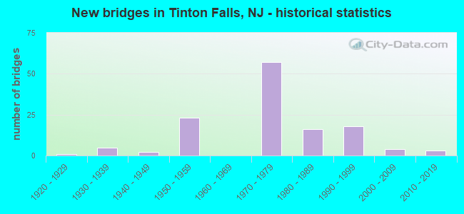
- New bridges - historical statistics
- 11920-1929
- 51930-1939
- 21940-1949
- 231950-1959
- 571970-1979
- 161980-1989
- 181990-1999
- 42000-2009
- 32010-2019

- Reconstructed bridges - Historical Statistics
- 11940-1949
- 11950-1959
- 11960-1969
- 01970-1979
- 61980-1989
- 01990-1999
- 02000-2009
- 12010-2019


- Bridge Condition - Deck
- 5.6%Very good
- 64.8%Good
- 26.8%Satisfactory
- 1.4%Fair
- 1.4%Poor

- Bridge Condition - Superstructure
- 12.7%Very good
- 46.5%Good
- 26.8%Satisfactory
- 11.3%Fair
- 2.8%Poor

- Bridge Condition - Substructure
- 2.8%Very good
- 69.0%Good
- 26.8%Satisfactory
- 1.4%Fair

- Bridge Condition - Channel
- 5.3%Very good
- 36.8%Good
- 42.1%Satisfactory
- 15.8%Fair

- Bridge Condition - Culverts
- 66.7%Good
- 33.3%Fair
Find on map >> Show street view
Structure Number: 13000N1, Location: 0.55 MI N NJ 66 (Lat: 40.228200, Lng: -74.081400), Route carried "on" structure: City street , Year Built: 2000, Status: Open, Structure Length: 1.71m (5.61ft), Average Daily Traffic: 4,277 (year 2021), Truck Traffic: 3%, Average Future Daily Traffic: 5,219 (year 2041), Design Load: HS 20, Features Intersected: JUMPING BROOK, Facility Carried by Structure: JUMPING BROOK ROAD
Minimum Vertical Clearance: 30+ m (98+ ft), Kilometerpoint: 2.446, Lanes on structure: 2, Owner: County Highway Agency, Approaching Roadway Width: 14.8m (48.6ft), Material/Design: Prestressed concrete, Design/Construction: Slab, Number Of Spans In Main Unit: 2, Length of Maximum Span: 7.9m (25.9ft), Curb or Sidewalk Widths: Left: 1.5m (4.9ft), Right: 0.9m (3.0ft), Curb-To-Curb Width: 14.8m (48.6ft), Out-to-Out Width: 17.9m (58.7ft)
Condition: Deck: Good, Superstructure: Good, Substructure: Satisfactory, Channel: Good, Inventory Rating: 80.7 metric tons, Method Used To Determine Inventory Rating: Load Factor (LF), Structural Evaluation: Equal to present minimum criteria, Deck Geometry: Superior to present desirable criteria, Waterway Adequacy: Equal to present desirable criteria, Approach Roadway Alignment: Equal to present desirable criteria, Designated Inspection Frequency: Every 24 months, Inspection Date: May 2021, Deck Structure Type: Concrete Cast-file-Place, Wearing Surface/Protective System: Wearing Surface: Monolithic Concrete, Deck Protection: Galvanized Reinforcing
Find on map >> Show street view
Structure Number: 1300A51, Location: 0.89 miles S. of CR 537 (Lat: 40.289839, Lng: -74.121369), Route carried "on" structure: City street , Year Built: 1940, Status: Posted for load, Structure Length: 0.73m (2.40ft), Average Daily Traffic: 3,030 (year 2021), Truck Traffic: 1%, Average Future Daily Traffic: 3,698 (year 2041), Features Intersected: HOCKHOCKSON BROOK, Facility Carried by Structure: HOCKOCKSON ROAD
Minimum Vertical Clearance: 30+ m (98+ ft), Kilometerpoint: 0.000, Lanes on structure: 2, Owner: County Highway Agency, Approaching Roadway Width: 6.1m (20.0ft), Material/Design: Steel, Design/Construction: Stringer/Multi-beam, Number Of Spans In Main Unit: 1, Length of Maximum Span: 6.7m (22.0ft), Curb-To-Curb Width: 5.9m (19.4ft), Out-to-Out Width: 6.2m (20.3ft)
Condition: Deck: Satisfactory, Superstructure: Fair, Substructure: Satisfactory, Channel: Satisfactory, Operating Rating: 48.1 metric tons, Method Used To Determine Operating Rating: Load Factor (LF), Inventory Rating: 29.0 metric tons, Method Used To Determine Inventory Rating: Load Factor (LF), Structural Evaluation: Somewhat better than minimum adequacy, Deck Geometry: High priority of replacement, Waterway Adequacy: Better than present minimum criteria, Approach Roadway Alignment: Equal to present desirable criteria, Length Of Structure Improvement: 0.73m (2.40ft), Designated Inspection Frequency: Every 24 months, Inspection Date: April 2021, Bridge Improvement Cost: $405,000, Roadway Improvement Cost: $40,000, Total Project Cost: $582,000 ( Estimate for 2021), Deck Structure Type: Wood or Timber, Wearing Surface/Protective System: Wearing Surface: Bituminous
Find on map >> Show street view
Structure Number: 1300S13, Location: APPR. 2.4M west of NJ 35 (Lat: 40.304289, Lng: -74.100819), Route carried "on" structure: County highway 537, Year Built: 1997, Status: Open, Structure Length: 1.71m (5.61ft), Average Daily Traffic: 16,506 (year 2021), Truck Traffic: 4%, Average Future Daily Traffic: 20,140 (year 2041), Design Load: HS 25 or greater, Features Intersected: PINE BROOK
Minimum Vertical Clearance: 30+ m (98+ ft), Kilometerpoint: 100.021, Lanes on structure: 4, Owner: County Highway Agency, Approaching Roadway Width: 14.0m (45.9ft), Material/Design: Prestressed concrete, Design/Construction: Stringer/Multi-beam, Number Of Spans In Main Unit: 1, Length of Maximum Span: 15.8m (51.8ft), Curb-To-Curb Width: 13.9m (45.6ft), Out-to-Out Width: 15.5m (50.9ft)
Condition: Deck: Satisfactory, Superstructure: Good, Substructure: Good, Channel: Satisfactory, Operating Rating: 61.7 metric tons, Method Used To Determine Operating Rating: Load Factor (LF), Inventory Rating: 37.2 metric tons, Method Used To Determine Inventory Rating: Load Factor (LF), Structural Evaluation: Better than present minimum criteria, Deck Geometry: High priority of replacement, Waterway Adequacy: Superior to present desirable criteria, Approach Roadway Alignment: Equal to present desirable criteria, Designated Inspection Frequency: Every 24 months, Inspection Date: May 2021, Deck Structure Type: Concrete Cast-file-Place, Wearing Surface/Protective System: Wearing Surface: Other, Deck Protection: Galvanized Reinforcing
Find on map >> Show street view
Structure Number: 1300S15, Location: 0.6 MI. WEST HANCE AV. (Lat: 40.321761, Lng: -74.093411), Route carried "on" structure: City street , Year Built: 1931, Year Reconstructed: 1940, Status: Posted for load, Structure Length: 1.28m (4.20ft), Average Daily Traffic: 95 (year 2021), Truck Traffic: 3%, Average Future Daily Traffic: 116 (year 2041), Design Load: H 20, Features Intersected: PINE BROOK, Facility Carried by Structure: RIVERDALE AVE.
Minimum Vertical Clearance: 30+ m (98+ ft), Kilometerpoint: 0.000, Lanes on structure: 2, Owner: County Highway Agency, Approaching Roadway Width: 7.0m (23.0ft), Material/Design: Steel, Design/Construction: Stringer/Multi-beam, Number Of Spans In Main Unit: 1, Length of Maximum Span: 11.9m (39.0ft), Curb-To-Curb Width: 6.2m (20.3ft), Out-to-Out Width: 6.9m (22.6ft)
Condition: Deck: Poor, Superstructure: Poor, Substructure: Fair, Channel: Good, Operating Rating: 28.1 metric tons, Method Used To Determine Operating Rating: Load Factor (LF), Inventory Rating: 16.3 metric tons, Method Used To Determine Inventory Rating: Load Factor (LF), Structural Evaluation: Meets minimum limits, Deck Geometry: Somewhat better than minimum adequacy, Waterway Adequacy: Superior to present desirable criteria, Approach Roadway Alignment: Equal to present minimum criteria, Length Of Structure Improvement: 1.95m (6.40ft), Designated Inspection Frequency: Every 24 months, Other Special Inspection Frequency: Every 12 months, Inspection Date: May 2021, Other Special Inspection Date: May 2021, Bridge Improvement Cost: $1,776,000, Roadway Improvement Cost: $178,000, Total Project Cost: $3,000,000 ( Estimate for 2021), Deck Structure Type: Wood or Timber, Wearing Surface/Protective System: Wearing Surface: Bituminous
Find on map >> Show street view
Structure Number: 1300S16, Location: 0.75 MI E OF GSP 109 (Lat: 40.336250, Lng: -74.087611), Route carried "on" structure: County highway 520, Year Built: 1971, Status: Open, Structure Length: 5.33m (17.49ft), Average Daily Traffic: 33,612 (year 2021), Truck Traffic: 4%, Average Future Daily Traffic: 41,013 (year 2041), Design Load: HS 20+Mod, Features Intersected: SWIMMING RIVER
Minimum Vertical Clearance: 30+ m (98+ ft), Kilometerpoint: 25.025, Lanes on structure: 4, Base Highway Network: Yes, Owner: County Highway Agency, Approaching Roadway Width: 15.8m (51.8ft), Skew: 10 degrees, Navigation Control: Yes ( Vertical Clearance: 3.0m (9.8ft), Horizontal Clearance: 24.1m (79.1ft)), Material/Design: Prestressed concrete, Design/Construction: Stringer/Multi-beam, Number Of Spans In Main Unit: 2, Length of Maximum Span: 25.9m (85.0ft), Curb or Sidewalk Widths: Left: 1.5m (4.9ft), Right: 1.5m (4.9ft), Curb-To-Curb Width: 15.8m (51.8ft), Out-to-Out Width: 26.2m (86.0ft)
Condition: Deck: Good, Superstructure: Good, Substructure: Satisfactory, Channel: Good, Operating Rating: 58.1 metric tons, Method Used To Determine Operating Rating: Load Factor (LF), Inventory Rating: 27.2 metric tons, Method Used To Determine Inventory Rating: Load Factor (LF), Structural Evaluation: Equal to present minimum criteria, Deck Geometry: Meets minimum limits, Waterway Adequacy: Equal to present desirable criteria, Approach Roadway Alignment: Equal to present desirable criteria, Designated Inspection Frequency: Every 24 months, Underwater Inspection Frequency: Every 48 months, Inspection Date: May 2021, Underwater Inspection Date: July 2019, Deck Structure Type: Concrete Cast-file-Place, Wearing Surface/Protective System: Wearing Surface: Monolithic Concrete, Deck Protection: Galvanized Reinforcing
Find on map >> Show street view
Structure Number: 1300W37, Location: 1/2MILE SOUTH OF NJ 33 (Lat: 40.202781, Lng: -74.080919), Route carried "on" structure: City street , Year Built: 2002, Status: Open, Structure Length: 1.52m (4.99ft), Average Daily Traffic: 4,548 (year 2021), Truck Traffic: 3%, Average Future Daily Traffic: 5,549 (year 2041), Design Load: HS 25 or greater, Features Intersected: SHARK RIVER, Facility Carried by Structure: GULLY ROAD
Minimum Vertical Clearance: 30+ m (98+ ft), Kilometerpoint: 1.963, Lanes on structure: 2, Owner: County Highway Agency, Approaching Roadway Width: 11.0m (36.1ft), Skew: 2 degrees, Material/Design: Prestressed concrete continuous, Design/Construction: Slab, Number Of Spans In Main Unit: 2, Length of Maximum Span: 7.0m (23.0ft), Curb or Sidewalk Widths: Left: 1.5m (4.9ft), Right: 1.5m (4.9ft), Curb-To-Curb Width: 11.0m (36.1ft), Out-to-Out Width: 14.6m (47.9ft)
Condition: Deck: Good, Superstructure: Very good, Substructure: Good, Channel: Good, Inventory Rating: 66.2 metric tons, Method Used To Determine Inventory Rating: Load Factor (LF), Structural Evaluation: Better than present minimum criteria, Deck Geometry: Somewhat better than minimum adequacy, Waterway Adequacy: Equal to present desirable criteria, Approach Roadway Alignment: Equal to present desirable criteria, Designated Inspection Frequency: Every 24 months, Inspection Date: May 2021, Deck Structure Type: Concrete Cast-file-Place, Wearing Surface/Protective System: Wearing Surface: Monolithic Concrete, Deck Protection: Galvanized Reinforcing
Find on map >> Show street view
Structure Number: 1300W38, Location: 0.2 MI. EAST G.S. PARKWAY (Lat: 40.205561, Lng: -74.092169), Route carried "on" structure: City street , Year Built: 2018, Status: Open, Structure Length: 1.07m (3.51ft), Average Daily Traffic: 673 (year 2021), Truck Traffic: 1%, Average Future Daily Traffic: 807 (year 2041), Design Load: HL 93, Features Intersected: SHARK RIVER, Facility Carried by Structure: SCHOOLHOUSE ROAD
Minimum Vertical Clearance: 30+ m (98+ ft), Kilometerpoint: 0.000, Lanes on structure: 2, Owner: County Highway Agency, Maintenance Responsibility: City or Municipal Highway Agency, Approaching Roadway Width: 11.0m (36.1ft), Material/Design: Prestressed concrete, Design/Construction: Box Beam or Girders - Multiple, Number Of Spans In Main Unit: 1, Length of Maximum Span: 9.1m (29.9ft), Curb or Sidewalk Widths: Left: 1.8m (5.9ft), Right: 1.8m (5.9ft), Curb-To-Curb Width: 11.0m (36.1ft), Out-to-Out Width: 15.3m (50.2ft)
Condition: Deck: Good, Superstructure: Very good, Substructure: Very good, Channel: Satisfactory, Operating Rating: 54.4 metric tons, Method Used To Determine Operating Rating: Field evaluation and documented engineering judgment, Inventory Rating: 32.7 metric tons, Method Used To Determine Inventory Rating: Field evaluation and documented engineering judgment, Structural Evaluation: Equal to present desirable criteria, Deck Geometry: Better than present minimum criteria, Waterway Adequacy: Superior to present desirable criteria, Approach Roadway Alignment: Equal to present minimum criteria, Length Of Structure Improvement: 1.71m (5.61ft), Designated Inspection Frequency: Every 24 months, Inspection Date: April 2021, Bridge Improvement Cost: $959,000, Roadway Improvement Cost: $144,000, Total Project Cost: $1,716,000 ( Estimate for 2015), Deck Structure Type: Concrete Cast-file-Place, Wearing Surface/Protective System: Wearing Surface: Monolithic Concrete, Deck Protection: Epoxy Coated Reinforcing
Find on map >> Show street view
Structure Number: 130815, Location: NJ 34 & 33 JCT (Lat: 40.227081, Lng: -74.145431), Route carried "on" structure: State highway 34, Year Built: 1936, Status: Open, Structure Length: 1.04m (3.41ft), Average Daily Traffic: 11,224 (year 2020), Truck Traffic: 4%, Average Future Daily Traffic: 13,696 (year 2040), Design Load: H 20, Features Intersected: NJ 33 WB
Minimum Vertical Clearance: 30+ m (98+ ft), Kilometerpoint: 14.098, Lanes on structure: 1, Lanes under structure: 1, Owner: State Highway Agency, Approaching Roadway Width: 7.3m (24.0ft), Skew: 1 degrees, Material/Design: Steel, Design/Construction: Stringer/Multi-beam, Number Of Spans In Main Unit: 1, Length of Maximum Span: 9.8m (32.2ft), Curb or Sidewalk Widths: Left: 0.2m (0.7ft), Right: 0.2m (0.7ft), Curb-To-Curb Width: 7.3m (24.0ft), Out-to-Out Width: 8.5m (27.9ft)
Condition: Deck: Good, Superstructure: Good, Substructure: Satisfactory, Operating Rating: 55.3 metric tons, Method Used To Determine Operating Rating: Load Factor (LF), Inventory Rating: 33.6 metric tons, Method Used To Determine Inventory Rating: Load Factor (LF), Structural Evaluation: Equal to present minimum criteria, Deck Geometry: High priority of replacement, Underclear: High priority of corrective action, Approach Roadway Alignment: Somewhat better than minimum adequacy, Length Of Structure Improvement: 1.04m (3.41ft), Designated Inspection Frequency: Every 24 months, Inspection Date: June 2020, Bridge Improvement Cost: $233,000, Roadway Improvement Cost: $24,000, Total Project Cost: $343,000 ( Estimate for 2020), Deck Structure Type: Concrete Cast-file-Place, Wearing Surface/Protective System: Wearing Surface: Bituminous, Membrane: Other
Find on map >> Show street view
Structure Number: 1308156, Location: 0.94 MI S OF RTE 537 JCT (Lat: 40.274289, Lng: -74.167839), Route carried "on" structure: State highway 34, Year Built: 1973, Status: Open, Structure Length: 6.16m (20.21ft), Average Daily Traffic: 7,961 (year 2020), Truck Traffic: 4%, Average Future Daily Traffic: 9,554 (year 2040), Design Load: HL 93, Features Intersected: NJ 18
Minimum Vertical Clearance: 30+ m (98+ ft), Kilometerpoint: 19.747, Lanes on structure: 3, Lanes under structure: 6, Base Highway Network: Yes, Owner: State Highway Agency, Approaching Roadway Width: 12.8m (42.0ft), Skew: 1 degrees, Material/Design: Steel, Design/Construction: Stringer/Multi-beam, Number Of Spans In Main Unit: 2, Length of Maximum Span: 29.9m (98.1ft), Curb or Sidewalk Widths: Left: 0.2m (0.7ft), Right: 1.1m (3.6ft), Curb-To-Curb Width: 12.8m (42.0ft), Out-to-Out Width: 15.5m (50.9ft)
Condition: Deck: Satisfactory, Superstructure: Very good, Substructure: Good, Operating Rating: 50.2 metric tons, Method Used To Determine Operating Rating: Load and Resistance Factor Rating (LRFR) rating reported by rating factor(RF) method using HL-93 loadings, Inventory Rating: 38.6 metric tons, Method Used To Determine Inventory Rating: Load and Resistance Factor Rating (LRFR) rating reported by rating factor(RF) method using HL-93 loadings, Structural Evaluation: Better than present minimum criteria, Deck Geometry: Meets minimum limits, Underclear: Meets minimum limits, Approach Roadway Alignment: Equal to present desirable criteria, Designated Inspection Frequency: Every 24 months, Inspection Date: August 2020, Deck Structure Type: Concrete Cast-file-Place, Wearing Surface/Protective System: Wearing Surface: Monolithic Concrete
Find on map >> Show street view
Structure Number: 1308157, Location: 3.3 MI.S.OF 18-537 INTER. (Lat: 40.274181, Lng: -74.168061), Route carried "on" structure: State highway 34, Year Built: 1973, Status: Open, Structure Length: 6.16m (20.21ft), Average Daily Traffic: 7,961 (year 2020), Truck Traffic: 4%, Average Future Daily Traffic: 9,521 (year 2040), Design Load: HS 20, Features Intersected: NJ 18
Minimum Vertical Clearance: 30+ m (98+ ft), Kilometerpoint: 19.747, Lanes on structure: 3, Lanes under structure: 6, Base Highway Network: Yes, Owner: State Highway Agency, Approaching Roadway Width: 12.8m (42.0ft), Skew: 1 degrees, Material/Design: Steel, Design/Construction: Stringer/Multi-beam, Number Of Spans In Main Unit: 2, Length of Maximum Span: 29.9m (98.1ft), Curb or Sidewalk Widths: Left: 1.1m (3.6ft), Right: 0.2m (0.7ft), Curb-To-Curb Width: 12.9m (42.3ft), Out-to-Out Width: 15.5m (50.9ft)
Condition: Deck: Good, Superstructure: Very good, Substructure: Good, Operating Rating: 72.6 metric tons, Method Used To Determine Operating Rating: Load Factor (LF), Inventory Rating: 43.5 metric tons, Method Used To Determine Inventory Rating: Load Factor (LF), Structural Evaluation: Better than present minimum criteria, Deck Geometry: Meets minimum limits, Underclear: High priority of corrective action, Approach Roadway Alignment: Equal to present desirable criteria, Length Of Structure Improvement: 6.16m (20.21ft), Designated Inspection Frequency: Every 24 months, Inspection Date: August 2020, Bridge Improvement Cost: $960,000, Roadway Improvement Cost: $196,000, Total Project Cost: $1,494,000 ( Estimate for 2020), Deck Structure Type: Concrete Cast-file-Place, Wearing Surface/Protective System: Wearing Surface: Monolithic Concrete
Find on map >> Show street view
Structure Number: 1318153, Location: 0.34 N of GSP (Lat: 40.220800, Lng: -74.092439), Route carried "on" structure: City street , Year Built: 2008, Status: Open, Structure Length: 5.82m (19.09ft), Average Daily Traffic: 6,210 (year 2020), Truck Traffic: 3%, Average Future Daily Traffic: 7,452 (year 2040), Design Load: HS 20, Features Intersected: ROUTE 66, Facility Carried by Structure: VICTORIA BOULEVARD
Minimum Vertical Clearance: 30+ m (98+ ft), Kilometerpoint: 0.966, Lanes on structure: 2, Lanes under structure: 6, Owner: State Highway Agency, Approaching Roadway Width: 15.8m (51.8ft), Skew: 3 degrees, Material/Design: Steel, Design/Construction: Stringer/Multi-beam, Number Of Spans In Main Unit: 2, Length of Maximum Span: 28.0m (91.9ft), Curb or Sidewalk Widths: Left: 0.0m, Right: 2.1m (6.9ft), Curb-To-Curb Width: 15.8m (51.8ft), Out-to-Out Width: 18.8m (61.7ft)
Condition: Deck: Very good, Superstructure: Very good, Substructure: Very good, Operating Rating: 74.4 metric tons, Method Used To Determine Operating Rating: Load Factor (LF), Inventory Rating: 44.5 metric tons, Method Used To Determine Inventory Rating: Load Factor (LF), Structural Evaluation: Equal to present desirable criteria, Deck Geometry: Superior to present desirable criteria, Underclear: Equal to present desirable criteria, Approach Roadway Alignment: Equal to present desirable criteria, Designated Inspection Frequency: Every 24 months, Inspection Date: March 2020, Deck Structure Type: Concrete Cast-file-Place, Wearing Surface/Protective System: Deck Protection: Galvanized Reinforcing
Find on map >> Show street view
Structure Number: 132315, Location: 0.2 MILES NORTH OF GSP (Lat: 40.280711, Lng: -74.088469), Route carried "on" structure: State highway 18, Year Built: 1979, Status: Open, Structure Length: 3.78m (12.40ft), Average Daily Traffic: 20,634 (year 2021), Truck Traffic: 5%, Average Future Daily Traffic: 30,996 (year 2041), Design Load: HS 20+Mod, Features Intersected: WAYSIDE ROAD
Minimum Vertical Clearance: 30+ m (98+ ft), Kilometerpoint: 23.352, Lanes on structure: 3, Lanes under structure: 3, Base Highway Network: Yes, Owner: State Highway Agency, Approaching Roadway Width: 15.5m (50.9ft), Skew: 2 degrees, Material/Design: Steel, Design/Construction: Stringer/Multi-beam, Number Of Spans In Main Unit: 1, Length of Maximum Span: 36.6m (120.1ft), Curb-To-Curb Width: 15.8m (51.8ft), Out-to-Out Width: 17.6m (57.7ft)
Condition: Deck: Satisfactory, Superstructure: Poor, Substructure: Good, Operating Rating: 82.6 metric tons, Method Used To Determine Operating Rating: Load Factor (LF), Inventory Rating: 49.9 metric tons, Method Used To Determine Inventory Rating: Load Factor (LF), Structural Evaluation: Meets minimum limits, Deck Geometry: Somewhat better than minimum adequacy, Underclear: Equal to present minimum criteria, Approach Roadway Alignment: Equal to present desirable criteria, Length Of Structure Improvement: 3.78m (12.40ft), Designated Inspection Frequency: Every 24 months, Inspection Date: April 2021, Bridge Improvement Cost: $3,956,000, Total Project Cost: $5,500,000 ( Estimate for 2021), Deck Structure Type: Concrete Cast-file-Place, Wearing Surface/Protective System: Wearing Surface: Monolithic Concrete
Find on map >> Show street view
Structure Number: 1323151, Location: .26 MILES NORTH OF GS PKY (Lat: 40.281061, Lng: -74.088339), Route carried "on" structure: State highway 18, Year Built: 1979, Status: Open, Structure Length: 3.96m (12.99ft), Average Daily Traffic: 19,665 (year 2020), Truck Traffic: 5%, Average Future Daily Traffic: 30,665 (year 2040), Design Load: HS 20, Features Intersected: WAYSIDE ROAD
Minimum Vertical Clearance: 30+ m (98+ ft), Kilometerpoint: 23.352, Lanes on structure: 2, Lanes under structure: 3, Base Highway Network: Yes, Owner: State Highway Agency, Approaching Roadway Width: 12.8m (42.0ft), Skew: 2 degrees, Material/Design: Steel, Design/Construction: Stringer/Multi-beam, Number Of Spans In Main Unit: 1, Length of Maximum Span: 38.4m (126.0ft), Curb-To-Curb Width: 13.0m (42.7ft), Out-to-Out Width: 14.8m (48.6ft)
Condition: Deck: Good, Superstructure: Fair, Substructure: Good, Inventory Rating: 69.9 metric tons, Method Used To Determine Inventory Rating: Load Factor (LF), Structural Evaluation: Somewhat better than minimum adequacy, Deck Geometry: Superior to present desirable criteria, Underclear: Equal to present minimum criteria, Approach Roadway Alignment: Equal to present desirable criteria, Designated Inspection Frequency: Every 24 months, Inspection Date: August 2020, Deck Structure Type: Concrete Cast-file-Place, Wearing Surface/Protective System: Wearing Surface: Monolithic Concrete, Deck Protection: Epoxy Coated Reinforcing
Find on map >> Show street view
Structure Number: 1323152, Location: 0.5 MI NORTH OF GSP JCT (Lat: 40.282939, Lng: -74.097681), Route carried "on" structure: State highway 18, Year Built: 1979, Status: Open, Structure Length: 3.41m (11.19ft), Average Daily Traffic: 20,582 (year 2021), Truck Traffic: 5%, Average Future Daily Traffic: 25,110 (year 2041), Design Load: HS 20, Features Intersected: HAMILTON ROAD
Minimum Vertical Clearance: 30+ m (98+ ft), Kilometerpoint: 24.156, Lanes on structure: 2, Lanes under structure: 2, Base Highway Network: Yes, Owner: State Highway Agency, Approaching Roadway Width: 13.0m (42.7ft), Skew: 2 degrees, Material/Design: Steel, Design/Construction: Stringer/Multi-beam, Number Of Spans In Main Unit: 1, Length of Maximum Span: 32.9m (107.9ft), Curb-To-Curb Width: 13.0m (42.7ft), Out-to-Out Width: 14.7m (48.2ft)
Condition: Deck: Good, Superstructure: Good, Substructure: Good, Inventory Rating: 59.9 metric tons, Method Used To Determine Inventory Rating: Load Factor (LF), Structural Evaluation: Better than present minimum criteria, Deck Geometry: Superior to present desirable criteria, Underclear: Equal to present minimum criteria, Approach Roadway Alignment: Equal to present desirable criteria, Designated Inspection Frequency: Every 24 months, Inspection Date: June 2021, Deck Structure Type: Concrete Cast-file-Place, Wearing Surface/Protective System: Wearing Surface: Monolithic Concrete, Deck Protection: Epoxy Coated Reinforcing
Find on map >> Show street view
Structure Number: 1323153, Location: .55 MILES SOUTH OF GS PKY (Lat: 40.283211, Lng: -74.097331), Route carried "on" structure: State highway 18, Year Built: 1979, Status: Open, Structure Length: 3.41m (11.19ft), Average Daily Traffic: 20,582 (year 2021), Truck Traffic: 5%, Average Future Daily Traffic: 25,110 (year 2041), Design Load: HS 20, Features Intersected: HAMILTON ROAD
Minimum Vertical Clearance: 30+ m (98+ ft), Kilometerpoint: 24.156, Lanes on structure: 2, Lanes under structure: 2, Base Highway Network: Yes, Owner: State Highway Agency, Approaching Roadway Width: 12.8m (42.0ft), Skew: 2 degrees, Material/Design: Steel, Design/Construction: Stringer/Multi-beam, Number Of Spans In Main Unit: 1, Length of Maximum Span: 32.9m (107.9ft), Curb-To-Curb Width: 13.0m (42.7ft), Out-to-Out Width: 14.7m (48.2ft)
Condition: Deck: Good, Superstructure: Good, Substructure: Good, Inventory Rating: 59.9 metric tons, Method Used To Determine Inventory Rating: Load Factor (LF), Structural Evaluation: Better than present minimum criteria, Deck Geometry: Superior to present desirable criteria, Underclear: Superior to present desirable criteria, Approach Roadway Alignment: Equal to present desirable criteria, Designated Inspection Frequency: Every 24 months, Inspection Date: June 2021, Deck Structure Type: Concrete Cast-file-Place, Wearing Surface/Protective System: Wearing Surface: Monolithic Concrete, Deck Protection: Epoxy Coated Reinforcing
Find on map >> Show street view
Structure Number: 1323154, Location: 4 MILES S OF RT 34 JCT (Lat: 40.283281, Lng: -74.099000), Route carried "on" structure: State highway 18, Year Built: 1979, Status: Open, Structure Length: 4.66m (15.29ft), Average Daily Traffic: 20,717 (year 2021), Truck Traffic: 5%, Average Future Daily Traffic: 24,861 (year 2041), Design Load: HS 20, Features Intersected: CONRAIL
Minimum Vertical Clearance: 7.62m (25.00ft), Kilometerpoint: 24.237, Lanes on structure: 2, Base Highway Network: Yes, Owner: State Highway Agency, Approaching Roadway Width: 12.8m (42.0ft), Skew: 3 degrees, Material/Design: Steel, Design/Construction: Stringer/Multi-beam, Number Of Spans In Main Unit: 1, Length of Maximum Span: 45.1m (148.0ft), Curb-To-Curb Width: 13.0m (42.7ft), Out-to-Out Width: 14.7m (48.2ft)
Condition: Deck: Good, Superstructure: Good, Substructure: Satisfactory, Inventory Rating: 56.2 metric tons, Method Used To Determine Inventory Rating: Load Factor (LF), Structural Evaluation: Equal to present minimum criteria, Deck Geometry: Superior to present desirable criteria, Underclear: Superior to present desirable criteria, Approach Roadway Alignment: Equal to present desirable criteria, Designated Inspection Frequency: Every 24 months, Inspection Date: April 2021, Deck Structure Type: Concrete Cast-file-Place, Wearing Surface/Protective System: Wearing Surface: Monolithic Concrete, Deck Protection: Epoxy Coated Reinforcing
Find on map >> Show street view
Structure Number: 1323155, Location: 0.7 MI NORTH OF GSP JCT (Lat: 40.283319, Lng: -74.098181), Route carried "on" structure: State highway 18, Year Built: 1979, Status: Open, Structure Length: 4.57m (14.99ft), Average Daily Traffic: 41,633 (year 2021), Truck Traffic: 5%, Average Future Daily Traffic: 50,800 (year 2041), Design Load: HS 20, Features Intersected: NEW JERSEY TRANSIT
Minimum Vertical Clearance: 30+ m (98+ ft), Kilometerpoint: 24.237, Lanes on structure: 2, Base Highway Network: Yes, Owner: State Highway Agency, Approaching Roadway Width: 12.8m (42.0ft), Skew: 3 degrees, Material/Design: Steel, Design/Construction: Stringer/Multi-beam, Number Of Spans In Main Unit: 1, Length of Maximum Span: 45.1m (148.0ft), Curb-To-Curb Width: 13.0m (42.7ft), Out-to-Out Width: 14.7m (48.2ft)
Condition: Deck: Good, Superstructure: Good, Substructure: Good, Operating Rating: 78.0 metric tons, Method Used To Determine Operating Rating: Load Factor (LF), Inventory Rating: 47.2 metric tons, Method Used To Determine Inventory Rating: Load Factor (LF), Structural Evaluation: Better than present minimum criteria, Deck Geometry: Superior to present desirable criteria, Underclear: Superior to present desirable criteria, Approach Roadway Alignment: Equal to present desirable criteria, Designated Inspection Frequency: Every 24 months, Inspection Date: June 2021, Deck Structure Type: Concrete Cast-file-Place, Wearing Surface/Protective System: Wearing Surface: Monolithic Concrete, Deck Protection: Epoxy Coated Reinforcing
Find on map >> Show street view
Structure Number: 1323156, Location: 1.0 MILES NORTH OF GS PKY (Lat: 40.283950, Lng: -74.102361), Route carried "on" structure: State highway 18, Year Built: 1979, Status: Open, Structure Length: 5.64m (18.50ft), Average Daily Traffic: 41,164 (year 2021), Truck Traffic: 5%, Average Future Daily Traffic: 50,228 (year 2041), Design Load: HS 20, Features Intersected: SQUANKUM ROAD
Minimum Vertical Clearance: 30+ m (98+ ft), Kilometerpoint: 24.510, Lanes on structure: 2, Lanes under structure: 2, Base Highway Network: Yes, Owner: State Highway Agency, Approaching Roadway Width: 12.8m (42.0ft), Skew: 5 degrees, Material/Design: Steel, Design/Construction: Stringer/Multi-beam, Number Of Spans In Main Unit: 3, Length of Maximum Span: 29.6m (97.1ft), Curb-To-Curb Width: 13.0m (42.7ft), Out-to-Out Width: 14.7m (48.2ft)
Condition: Deck: Good, Superstructure: Satisfactory, Substructure: Good, Inventory Rating: 59.9 metric tons, Method Used To Determine Inventory Rating: Load Factor (LF), Structural Evaluation: Equal to present minimum criteria, Deck Geometry: Superior to present desirable criteria, Underclear: Equal to present minimum criteria, Approach Roadway Alignment: Better than present minimum criteria, Designated Inspection Frequency: Every 24 months, Inspection Date: June 2021, Deck Structure Type: Concrete Cast-file-Place, Wearing Surface/Protective System: Wearing Surface: Monolithic Concrete, Deck Protection: Epoxy Coated Reinforcing
Find on map >> Show street view
Structure Number: 1323157, Location: 1.45 MI NORTH OF GSP (Lat: 40.283231, Lng: -74.111169), Route carried "on" structure: State highway 18, Year Built: 1977, Status: Open, Structure Length: 0.61m (2.00ft), Average Daily Traffic: 40,208 (year 2021), Truck Traffic: 5%, Average Future Daily Traffic: 49,062 (year 2041), Design Load: HS 20, Features Intersected: PINE BROOK
Minimum Vertical Clearance: 30+ m (98+ ft), Kilometerpoint: 25.331, Lanes on structure: 4, Base Highway Network: Yes, Owner: State Highway Agency, Approaching Roadway Width: 40.2m (131.9ft), Skew: 21 degrees, Material/Design: Concrete, Design/Construction: Culvert, Number Of Spans In Main Unit: 1, Length of Maximum Span: 6.1m (20.0ft)
Condition: Channel: Fair, Culverts: Good, Operating Rating: 54.4 metric tons, Method Used To Determine Operating Rating: Load Factor (LF), Inventory Rating: 32.7 metric tons, Method Used To Determine Inventory Rating: Load Factor (LF), Structural Evaluation: Better than present minimum criteria, Waterway Adequacy: Equal to present minimum criteria, Approach Roadway Alignment: Equal to present desirable criteria, Designated Inspection Frequency: Every 24 months, Inspection Date: June 2021
Find on map >> Show street view
Structure Number: 1323158, Location: 1.7 MILES NORTH OF GS PKY (Lat: 40.283331, Lng: -74.116669), Route carried "on" structure: City street , Year Built: 1979, Status: Open, Structure Length: 6.04m (19.82ft), Average Daily Traffic: 2,195 (year 2021), Truck Traffic: 3%, Average Future Daily Traffic: 2,678 (year 2041), Design Load: HS 20, Features Intersected: NJ 18 Freeway, Facility Carried by Structure: OBRE ROAD
Minimum Vertical Clearance: 30+ m (98+ ft), Kilometerpoint: 0.000, Lanes on structure: 2, Lanes under structure: 4, Owner: State Highway Agency, Approaching Roadway Width: 12.2m (40.0ft), Material/Design: Steel, Design/Construction: Stringer/Multi-beam, Number Of Spans In Main Unit: 2, Length of Maximum Span: 29.3m (96.1ft), Curb or Sidewalk Widths: Left: 1.8m (5.9ft), Right: 0.2m (0.7ft), Curb-To-Curb Width: 9.4m (30.8ft), Out-to-Out Width: 12.7m (41.7ft)
Condition: Deck: Satisfactory, Superstructure: Good, Substructure: Good, Operating Rating: 88.0 metric tons, Method Used To Determine Operating Rating: Load Factor (LF), Inventory Rating: 52.6 metric tons, Method Used To Determine Inventory Rating: Load Factor (LF), Structural Evaluation: Better than present minimum criteria, Deck Geometry: Meets minimum limits, Underclear: Meets minimum limits, Approach Roadway Alignment: Better than present minimum criteria, Length Of Structure Improvement: 6.04m (19.82ft), Designated Inspection Frequency: Every 24 months, Inspection Date: March 2021, Roadway Improvement Cost: $110,000, Total Project Cost: $121,000 ( Estimate for 2019), Deck Structure Type: Concrete Cast-file-Place, Wearing Surface/Protective System: Wearing Surface: Monolithic Concrete
Find on map >> Show street view
Structure Number: 132316, Location: 1.75 MI S OF RT 34 (Lat: 40.282289, Lng: -74.138831), Route carried "on" structure: State highway 18, Year Built: 1972, Status: Open, Structure Length: 1.07m (3.51ft), Average Daily Traffic: 43,065 (year 2021), Truck Traffic: 5%, Average Future Daily Traffic: 52,198 (year 2041), Design Load: HS 25 or greater, Features Intersected: HOCKHOCKSON BROOK
Minimum Vertical Clearance: 30+ m (98+ ft), Kilometerpoint: 27.793, Lanes on structure: 4, Base Highway Network: Yes, Owner: State Highway Agency, Approaching Roadway Width: 40.2m (131.9ft), Material/Design: Concrete, Design/Construction: Culvert, Number Of Spans In Main Unit: 2, Length of Maximum Span: 4.9m (16.1ft)
Condition: Channel: Fair, Culverts: Fair, Structural Evaluation: Somewhat better than minimum adequacy, Waterway Adequacy: Superior to present desirable criteria, Approach Roadway Alignment: Equal to present desirable criteria, Designated Inspection Frequency: Every 24 months, Inspection Date: July 2021
Find on map >> Show street view
Structure Number: 1323161, Location: 1.7 MI N. of GSP (Lat: 40.282181, Lng: -74.140619), Route carried "on" structure: State highway 18, Year Built: 1973, Status: Open, Structure Length: 5.30m (17.39ft), Average Daily Traffic: 20,310 (year 2020), Truck Traffic: 5%, Average Future Daily Traffic: 24,782 (year 2040), Design Load: HS 20, Features Intersected: NORMANDY RD & US GOVT RR
Minimum Vertical Clearance: 30+ m (98+ ft), Kilometerpoint: 27.906, Lanes on structure: 2, Lanes under structure: 2, Base Highway Network: Yes, Owner: State Highway Agency, Approaching Roadway Width: 13.0m (42.7ft), Skew: 1 degrees, Material/Design: Steel, Design/Construction: Stringer/Multi-beam, Number Of Spans In Main Unit: 2, Length of Maximum Span: 25.9m (85.0ft), Curb or Sidewalk Widths: Left: 0.2m (0.7ft), Right: 0.2m (0.7ft), Curb-To-Curb Width: 13.0m (42.7ft), Out-to-Out Width: 14.7m (48.2ft)
Condition: Deck: Good, Superstructure: Good, Substructure: Satisfactory, Operating Rating: 64.4 metric tons, Method Used To Determine Operating Rating: Load Factor (LF), Inventory Rating: 38.1 metric tons, Method Used To Determine Inventory Rating: Load Factor (LF), Structural Evaluation: Equal to present minimum criteria, Deck Geometry: Superior to present desirable criteria, Underclear: Somewhat better than minimum adequacy, Approach Roadway Alignment: Equal to present desirable criteria, Designated Inspection Frequency: Every 24 months, Inspection Date: August 2020, Deck Structure Type: Concrete Cast-file-Place, Wearing Surface/Protective System: Wearing Surface: Monolithic Concrete
Find on map >> Show street view
Structure Number: 1323162, Location: 2.7 Mi. N. OF GSP (Lat: 40.282461, Lng: -74.140019), Route carried "on" structure: State highway 18, Year Built: 1973, Status: Open, Structure Length: 5.30m (17.39ft), Average Daily Traffic: 20,308 (year 2020), Truck Traffic: 5%, Average Future Daily Traffic: 23,893 (year 2040), Design Load: HS 20, Features Intersected: Normandy Rd & US Govt RR
Minimum Vertical Clearance: 30+ m (98+ ft), Kilometerpoint: 27.906, Lanes on structure: 2, Lanes under structure: 2, Base Highway Network: Yes, Owner: State Highway Agency, Approaching Roadway Width: 12.8m (42.0ft), Skew: 1 degrees, Material/Design: Steel, Design/Construction: Stringer/Multi-beam, Number Of Spans In Main Unit: 2, Length of Maximum Span: 25.9m (85.0ft), Curb or Sidewalk Widths: Left: 0.2m (0.7ft), Right: 0.2m (0.7ft), Curb-To-Curb Width: 13.0m (42.7ft), Out-to-Out Width: 14.7m (48.2ft)
Condition: Deck: Satisfactory, Superstructure: Satisfactory, Substructure: Satisfactory, Operating Rating: 64.4 metric tons, Method Used To Determine Operating Rating: Load Factor (LF), Inventory Rating: 38.1 metric tons, Method Used To Determine Inventory Rating: Load Factor (LF), Structural Evaluation: Equal to present minimum criteria, Deck Geometry: Superior to present desirable criteria, Underclear: Somewhat better than minimum adequacy, Approach Roadway Alignment: Equal to present desirable criteria, Designated Inspection Frequency: Every 24 months, Inspection Date: August 2020, Deck Structure Type: Concrete Cast-file-Place, Wearing Surface/Protective System: Wearing Surface: Monolithic Concrete
Find on map >> Show street view
Structure Number: 1323166, Location: 0.9 MI NORTH OF GSP JCT (Lat: 40.284119, Lng: -74.101039), Route carried "on" structure: State highway 18, Year Built: 1979, Status: Open, Structure Length: 5.55m (18.21ft), Average Daily Traffic: 20,176 (year 2021), Truck Traffic: 5%, Average Future Daily Traffic: 24,211 (year 2041), Design Load: HS 20, Features Intersected: SQUANKUM ROAD
Minimum Vertical Clearance: 30+ m (98+ ft), Kilometerpoint: 24.510, Lanes on structure: 2, Lanes under structure: 2, Base Highway Network: Yes, Owner: State Highway Agency, Approaching Roadway Width: 12.8m (42.0ft), Skew: 5 degrees, Material/Design: Steel, Design/Construction: Stringer/Multi-beam, Number Of Spans In Main Unit: 3, Length of Maximum Span: 28.3m (92.8ft), Curb-To-Curb Width: 13.0m (42.7ft), Out-to-Out Width: 14.7m (48.2ft)
Condition: Deck: Satisfactory, Superstructure: Good, Substructure: Good, Operating Rating: 77.1 metric tons, Method Used To Determine Operating Rating: Load Factor (LF), Inventory Rating: 46.3 metric tons, Method Used To Determine Inventory Rating: Load Factor (LF), Structural Evaluation: Better than present minimum criteria, Deck Geometry: Superior to present desirable criteria, Underclear: Better than present minimum criteria, Approach Roadway Alignment: Equal to present desirable criteria, Designated Inspection Frequency: Every 24 months, Inspection Date: July 2021, Deck Structure Type: Concrete Cast-file-Place, Wearing Surface/Protective System: Wearing Surface: Monolithic Concrete, Deck Protection: Epoxy Coated Reinforcing
Find on map >> Show street view
Structure Number: 1329163, Location: 0.34 MI. SOUTH OF GSP. (Lat: 40.280350, Lng: -74.077750), Route carried "on" structure: State highway 18, Year Built: 1991, Status: Open, Structure Length: 6.25m (20.51ft), Average Daily Traffic: 21,023 (year 2020), Truck Traffic: 5%, Average Future Daily Traffic: 25,652 (year 2040), Design Load: HS 20+Mod, Features Intersected: HOPE RD.
Minimum Vertical Clearance: 30+ m (98+ ft), Kilometerpoint: 22.402, Lanes on structure: 3, Lanes under structure: 2, Base Highway Network: Yes, Owner: State Highway Agency, Approaching Roadway Width: 15.5m (50.9ft), Skew: 2 degrees, Material/Design: Steel, Design/Construction: Stringer/Multi-beam, Number Of Spans In Main Unit: 3, Length of Maximum Span: 32.9m (107.9ft), Curb-To-Curb Width: 15.5m (50.9ft), Out-to-Out Width: 16.6m (54.5ft)
Condition: Deck: Good, Superstructure: Very good, Substructure: Good, Inventory Rating: 61.7 metric tons, Method Used To Determine Inventory Rating: Load Factor (LF), Structural Evaluation: Better than present minimum criteria, Deck Geometry: Somewhat better than minimum adequacy, Underclear: Better than present minimum criteria, Approach Roadway Alignment: Equal to present desirable criteria, Designated Inspection Frequency: Every 24 months, Inspection Date: April 2020, Deck Structure Type: Concrete Cast-file-Place, Wearing Surface/Protective System: Wearing Surface: Latex Concrete, Deck Protection: Epoxy Coated Reinforcing
Find on map >> Show street view
Structure Number: 1329165, Location: 0.6 MI SOUTH OF G.S.PKWAY (Lat: 40.280869, Lng: -74.078150), Route carried "on" structure: Ramp State highway 18, Year Built: 1991, Status: Open, Structure Length: 32.22m (105.71ft), Average Daily Traffic: 1,575 (year 2018), Truck Traffic: 4%, Average Future Daily Traffic: 2,042 (year 2038), Design Load: HS 20+Mod, Features Intersected: 18 NB,HOPE RD,NS&SN
Minimum Vertical Clearance: 30+ m (98+ ft), Kilometerpoint: 22.386, Lanes on structure: 1, Lanes under structure: 6, Owner: State Highway Agency, Approaching Roadway Width: 9.4m (30.8ft), Material/Design: Steel continuous, Design/Construction: Stringer/Multi-beam, Number Of Spans In Main Unit: 8, Length of Maximum Span: 64.0m (210.0ft), Curb-To-Curb Width: 9.4m (30.8ft), Out-to-Out Width: 10.5m (34.4ft)
Condition: Deck: Satisfactory, Superstructure: Good, Substructure: Good, Operating Rating: 68.0 metric tons, Method Used To Determine Operating Rating: Load Factor (LF), Inventory Rating: 39.9 metric tons, Method Used To Determine Inventory Rating: Load Factor (LF), Structural Evaluation: Better than present minimum criteria, Deck Geometry: Superior to present desirable criteria, Underclear: Better than present minimum criteria, Approach Roadway Alignment: Equal to present minimum criteria, Designated Inspection Frequency: Every 24 months, Inspection Date: August 2020, Deck Structure Type: Concrete Cast-file-Place, Wearing Surface/Protective System: Wearing Surface: Latex Concrete, Deck Protection: Epoxy Coated Reinforcing
Find on map >> Show street view
Structure Number: 1329168, Location: 0.1 MI. W. OF WAYSIDE RD. (Lat: 40.280531, Lng: -74.086350), Route carried "on" structure: State highway 18, Year Built: 1991, Status: Open, Structure Length: 32.98m (108.20ft), Average Daily Traffic: 20,570 (year 2021), Truck Traffic: 5%, Average Future Daily Traffic: 24,684 (year 2041), Design Load: HS 20+Mod, Features Intersected: GSP, RAMP F & RAMP
Minimum Vertical Clearance: 30+ m (98+ ft), Kilometerpoint: 22.933, Lanes on structure: 4, Lanes under structure: 13, Base Highway Network: Yes, Owner: State Highway Agency, Approaching Roadway Width: 16.8m (55.1ft), Skew: 3 degrees, Material/Design: Steel continuous, Design/Construction: Stringer/Multi-beam, Number Of Spans In Main Unit: 7, Length of Maximum Span: 53.0m (173.9ft), Curb-To-Curb Width: 16.8m (55.1ft), Out-to-Out Width: 17.8m (58.4ft)
Condition: Deck: Very good, Superstructure: Good, Substructure: Good, Operating Rating: 83.5 metric tons, Method Used To Determine Operating Rating: Load Factor (LF), Inventory Rating: 49.9 metric tons, Method Used To Determine Inventory Rating: Load Factor (LF), Structural Evaluation: Better than present minimum criteria, Deck Geometry: Meets minimum limits, Underclear: Equal to present minimum criteria, Approach Roadway Alignment: Equal to present desirable criteria, Designated Inspection Frequency: Every 24 months, Inspection Date: May 2021, Deck Structure Type: Concrete Cast-file-Place, Wearing Surface/Protective System: Wearing Surface: Latex Concrete, Deck Protection: Epoxy Coated Reinforcing
Find on map >> Show street view
Structure Number: 132917, Location: AT NJ 36 JUNCTION (Lat: 40.288331, Lng: -74.076669), Route carried "on" structure: Ramp State highway 18, Year Built: 1991, Status: Open, Structure Length: 20.97m (68.80ft), Average Daily Traffic: 4,625 (year 2020), Truck Traffic: 5%, Average Future Daily Traffic: 5,550 (year 2040), Design Load: HS 20+Mod, Features Intersected: ROUTE NJ 36 AND BROOK
Minimum Vertical Clearance: 30+ m (98+ ft), Kilometerpoint: 22.241, Lanes on structure: 1, Lanes under structure: 4, Owner: State Highway Agency, Approaching Roadway Width: 7.6m (24.9ft), Skew: 9 degrees, Material/Design: Steel continuous, Design/Construction: Stringer/Multi-beam, Number Of Spans In Main Unit: 3, Number Of Approach Spans: 1, Length of Maximum Span: 67.7m (222.1ft), Curb-To-Curb Width: 8.2m (26.9ft), Out-to-Out Width: 9.7m (31.8ft)
Condition: Deck: Good, Superstructure: Very good, Substructure: Good, Channel: Very good, Operating Rating: 64.4 metric tons, Method Used To Determine Operating Rating: Load Factor (LF), Inventory Rating: 38.1 metric tons, Method Used To Determine Inventory Rating: Load Factor (LF), Structural Evaluation: Better than present minimum criteria, Deck Geometry: Superior to present desirable criteria, Underclear: Somewhat better than minimum adequacy, Waterway Adequacy: Equal to present desirable criteria, Approach Roadway Alignment: Somewhat better than minimum adequacy, Designated Inspection Frequency: Every 24 months, Inspection Date: March 2020, Deck Structure Type: Concrete Cast-file-Place, Wearing Surface/Protective System: Wearing Surface: Latex Concrete, Deck Protection: Epoxy Coated Reinforcing
Find on map >> Show street view
Structure Number: 1329172, Location: 0.1 MI. W. OF WAYSIDE RD. (Lat: 40.280789, Lng: -74.086581), Route carried "on" structure: State highway 18, Year Built: 1991, Status: Open, Structure Length: 30.91m (101.41ft), Average Daily Traffic: 20,570 (year 2021), Truck Traffic: 5%, Average Future Daily Traffic: 24,684 (year 2041), Design Load: HS 20+Mod, Features Intersected: GARDEN ST. PKWY & RAMP F
Minimum Vertical Clearance: 30+ m (98+ ft), Kilometerpoint: 22.933, Lanes on structure: 3, Lanes under structure: 13, Base Highway Network: Yes, Owner: State Highway Agency, Approaching Roadway Width: 16.2m (53.1ft), Skew: 2 degrees, Material/Design: Steel continuous, Design/Construction: Stringer/Multi-beam, Number Of Spans In Main Unit: 8, Length of Maximum Span: 49.4m (162.1ft), Curb-To-Curb Width: 16.2m (53.1ft), Out-to-Out Width: 17.2m (56.4ft)
Condition: Deck: Good, Superstructure: Good, Substructure: Satisfactory, Operating Rating: 81.6 metric tons, Method Used To Determine Operating Rating: Load Factor (LF), Inventory Rating: 49.0 metric tons, Method Used To Determine Inventory Rating: Load Factor (LF), Structural Evaluation: Equal to present minimum criteria, Deck Geometry: Equal to present minimum criteria, Underclear: Equal to present minimum criteria, Approach Roadway Alignment: Equal to present desirable criteria, Designated Inspection Frequency: Every 24 months, Inspection Date: May 2021, Deck Structure Type: Concrete Cast-file-Place, Wearing Surface/Protective System: Wearing Surface: Latex Concrete, Deck Protection: Epoxy Coated Reinforcing
Find on map >> Show street view
Structure Number: 133715, Location: 0.30 MI E OF 33-34 JCT (Lat: 40.225281, Lng: -74.140869), Route carried "on" structure: State highway 33, Year Built: 1927, Year Reconstructed: 2016, Status: Open, Structure Length: 1.31m (4.30ft), Average Daily Traffic: 41,966 (year 2020), Truck Traffic: 4%, Average Future Daily Traffic: 50,359 (year 2040), Design Load: HL 93, Features Intersected: SOUTHERN DIVISION
Minimum Vertical Clearance: 30+ m (98+ ft), Kilometerpoint: 56.327, Lanes on structure: 2, Base Highway Network: Yes, Owner: State Highway Agency, Approaching Roadway Width: 12.6m (41.3ft), Material/Design: Steel, Design/Construction: Stringer/Multi-beam, Number Of Spans In Main Unit: 1, Length of Maximum Span: 11.6m (38.1ft), Curb or Sidewalk Widths: Left: 0.0m, Right: 2.5m (8.2ft), Curb-To-Curb Width: 12.6m (41.3ft), Out-to-Out Width: 15.7m (51.5ft)
Condition: Deck: Very good, Superstructure: Very good, Substructure: Satisfactory, Operating Rating: 51.2 metric tons, Method Used To Determine Operating Rating: Load and Resistance Factor Rating (LRFR) rating reported by rating factor(RF) method using HL-93 loadings, Inventory Rating: 43.4 metric tons, Method Used To Determine Inventory Rating: Load and Resistance Factor Rating (LRFR) rating reported by rating factor(RF) method using HL-93 loadings, Structural Evaluation: Equal to present minimum criteria, Deck Geometry: Better than present minimum criteria, Underclear: Meets minimum limits, Approach Roadway Alignment: Better than present minimum criteria, Designated Inspection Frequency: Every 24 months, Inspection Date: March 2020, Deck Structure Type: Concrete Precast Panels, Wearing Surface/Protective System: Wearing Surface: Monolithic Concrete, Deck Protection: Epoxy Coated Reinforcing
Find on map >> Show street view
Structure Number: 1337151, Location: 0.26 MI E OF 33-34 JCT. (Lat: 40.225000, Lng: -74.141669), Route carried "on" structure: State highway 33, Year Built: 1936, Status: Open, Structure Length: 1.25m (4.10ft), Average Daily Traffic: 12,496 (year 2020), Truck Traffic: 4%, Average Future Daily Traffic: 14,995 (year 2040), Design Load: H 20, Features Intersected: SOUTHERN DIVISION
Minimum Vertical Clearance: 30+ m (98+ ft), Kilometerpoint: 56.375, Lanes on structure: 2, Base Highway Network: Yes, Owner: State Highway Agency, Approaching Roadway Width: 9.8m (32.2ft), Material/Design: Steel, Design/Construction: Stringer/Multi-beam, Number Of Spans In Main Unit: 1, Length of Maximum Span: 11.3m (37.1ft), Curb or Sidewalk Widths: Left: 0.5m (1.6ft), Right: 1.7m (5.6ft), Curb-To-Curb Width: 9.8m (32.2ft), Out-to-Out Width: 13.2m (43.3ft)
Condition: Deck: Fair, Superstructure: Satisfactory, Substructure: Satisfactory, Operating Rating: 51.7 metric tons, Method Used To Determine Operating Rating: Load Factor (LF), Inventory Rating: 30.8 metric tons, Method Used To Determine Inventory Rating: Load Factor (LF), Structural Evaluation: Equal to present minimum criteria, Deck Geometry: Meets minimum limits, Underclear: Meets minimum limits, Approach Roadway Alignment: Better than present minimum criteria, Designated Inspection Frequency: Every 24 months, Inspection Date: March 2020, Deck Structure Type: Concrete Cast-file-Place, Wearing Surface/Protective System: Wearing Surface: Bituminous, Membrane: Other
Find on map >> Show street view
Structure Number: 1NJ0HB1, Location: 2 MI S OF RTS 18-34 JCT. (Lat: 40.247889, Lng: -74.154917), Route carried "on" structure: Other road , Year Built: 1943, Year Reconstructed: 1993, Status: Open, Structure Length: 3.44m (11.29ft), Average Daily Traffic: 110 (year 2007), Truck Traffic: 12%, Average Future Daily Traffic: 130 (year 2035), Features Intersected: SR-34, Facility Carried by Structure: MIDWAY RD,EARLE RR
Minimum Vertical Clearance: 30+ m (98+ ft), Kilometerpoint: 0.000, Lanes on structure: 1, Lanes under structure: 2, Owner: Navy/Marines, Approaching Roadway Width: 6.1m (20.0ft), Material/Design: Concrete continuous, Design/Construction: Stringer/Multi-beam, Number Of Spans In Main Unit: 2, Length of Maximum Span: 17.2m (56.4ft), Curb or Sidewalk Widths: Left: 0.2m (0.7ft), Right: 0.2m (0.7ft), Curb-To-Curb Width: 5.6m (18.4ft), Out-to-Out Width: 12.8m (42.0ft)
Condition: Deck: Good, Superstructure: Satisfactory, Substructure: Good, Operating Rating: 22.9 metric tons, Method Used To Determine Operating Rating: Load Factor (LF), Inventory Rating: 13.7 metric tons, Method Used To Determine Inventory Rating: Load Factor (LF), Structural Evaluation: Meets minimum limits, Deck Geometry: High priority of corrective action, Underclear: Somewhat better than minimum adequacy, Approach Roadway Alignment: Equal to present desirable criteria, Length Of Structure Improvement: 3.44m (11.29ft), Designated Inspection Frequency: Every 24 months, Inspection Date: July 2021, Bridge Improvement Cost: $15,000, Roadway Improvement Cost: $10,000, Total Project Cost: $35,000 ( Estimate for 2021), Deck Structure Type: Concrete Cast-file-Place, Wearing Surface/Protective System: Wearing Surface: Bituminous, Membrane: Preformed Fabric
Find on map >> Show street view
Structure Number: 1NJ0HB4, Location: 0.8MI S OF JCT CR-520 (Lat: 40.323917, Lng: -74.108833), Route carried "on" structure: Other road , Year Built: 1996, Status: Open, Structure Length: 13.17m (43.21ft), Average Daily Traffic: 120 (year 2007), Truck Traffic: 10%, Average Future Daily Traffic: 130 (year 2035), Design Load: HS 20+Mod, Features Intersected: SWIMMING RIVER, Facility Carried by Structure: NORMANY ROAD
Minimum Vertical Clearance: 30+ m (98+ ft), Kilometerpoint: 0.000, Lanes on structure: 2, Owner: Navy/Marines, Approaching Roadway Width: 7.9m (25.9ft), Material/Design: Steel, Design/Construction: Stringer/Multi-beam, Number Of Spans In Main Unit: 5, Length of Maximum Span: 33.4m (109.6ft), Curb-To-Curb Width: 8.1m (26.6ft), Out-to-Out Width: 9.1m (29.9ft)
Condition: Deck: Good, Superstructure: Satisfactory, Substructure: Good, Operating Rating: 50.0 metric tons, Method Used To Determine Operating Rating: Load Factor (LF), Inventory Rating: 30.0 metric tons, Method Used To Determine Inventory Rating: Load Factor (LF), Structural Evaluation: Equal to present minimum criteria, Deck Geometry: Somewhat better than minimum adequacy, Approach Roadway Alignment: Equal to present desirable criteria, Length Of Structure Improvement: 13.17m (43.21ft), Designated Inspection Frequency: Every 24 months, Inspection Date: July 2021, Bridge Improvement Cost: $29,000, Roadway Improvement Cost: $21,000, Total Project Cost: $50,000 ( Estimate for 2021), Deck Structure Type: Concrete Cast-file-Place, Wearing Surface/Protective System: Wearing Surface: Latex Concrete, Deck Protection: Epoxy Coated Reinforcing
Find on map >> Show street view
Structure Number: 1NJHB11, Location: 3KM S. OF CR537 (Lat: 40.281522, Lng: -74.140300), Route carried "on" structure: ServiceOther road , Year Built: 1972, Status: Open, Structure Length: 0.78m (2.56ft), Average Daily Traffic: 120 (year 2007), Truck Traffic: 10%, Average Future Daily Traffic: 130 (year 2035), Design Load: HS 20, Features Intersected: HOCKHOCKSON BROOK, Facility Carried by Structure: NORMANDY RD
Minimum Vertical Clearance: 30+ m (98+ ft), Kilometerpoint: 0.000, Lanes on structure: 2, Owner: Navy/Marines, Approaching Roadway Width: 6.7m (22.0ft), Skew: 1 degrees, Material/Design: Concrete, Design/Construction: Culvert, Number Of Spans In Main Unit: 2, Length of Maximum Span: 3.7m (12.1ft)
Condition: Channel: Fair, Culverts: Good, Operating Rating: 51.1 metric tons, Method Used To Determine Operating Rating: Load Factor (LF), Inventory Rating: 30.7 metric tons, Method Used To Determine Inventory Rating: Load Factor (LF), Structural Evaluation: Better than present minimum criteria, Waterway Adequacy: Equal to present desirable criteria, Approach Roadway Alignment: Equal to present desirable criteria, Length Of Structure Improvement: 2.93m (9.61ft), Designated Inspection Frequency: Every 24 months, Inspection Date: July 2021, Bridge Improvement Cost: $1,000, Roadway Improvement Cost: $5,000, Total Project Cost: $6,000 ( Estimate for 2021)
Find on map >> Show street view
Structure Number: 1NJHB2A, Location: 2.1 MI SE JCT. NJ 18 & 34 (Lat: 40.257178, Lng: -74.119175), Route carried "on" structure: Federal lands road , Year Built: 1936, Year Reconstructed: 1994, Status: Open, Structure Length: 1.26m (4.13ft), Average Daily Traffic: 50 (year 2007), Truck Traffic: 10%, Average Future Daily Traffic: 65 (year 2035), Design Load: HS 20, Features Intersected: CONRAIL RR, Facility Carried by Structure: ESPERANCE ROAD
Minimum Vertical Clearance: 30+ m (98+ ft), Kilometerpoint: 0.000, Lanes on structure: 2, Owner: Navy/Marines, Approaching Roadway Width: 14.2m (46.6ft), Material/Design: Concrete, Design/Construction: Stringer/Multi-beam, Number Of Spans In Main Unit: 1, Length of Maximum Span: 10.1m (33.1ft), Curb or Sidewalk Widths: Left: 0.0m, Right: 1.8m (5.9ft), Curb-To-Curb Width: 13.4m (44.0ft), Out-to-Out Width: 16.1m (52.8ft)
Condition: Deck: Good, Superstructure: Good, Substructure: Satisfactory, Inventory Rating: 56.6 metric tons, Method Used To Determine Inventory Rating: Load Factor (LF), Structural Evaluation: Equal to present minimum criteria, Deck Geometry: Superior to present desirable criteria, Underclear: Meets minimum limits, Approach Roadway Alignment: Equal to present minimum criteria, Length Of Structure Improvement: 1.26m (4.13ft), Designated Inspection Frequency: Every 24 months, Inspection Date: July 2021, Bridge Improvement Cost: $29,000, Roadway Improvement Cost: $16,000, Total Project Cost: $46,000 ( Estimate for 2021), Deck Structure Type: Concrete Cast-file-Place, Wearing Surface/Protective System: Wearing Surface: Integral Concrete
Find on map >> Show street view
Structure Number: 360999N, Location: 1.6 MI N OF NJ 138&GSP JC (Lat: 40.193961, Lng: -74.099189), Route carried "on" structure: Other road GSP, Year Built: 1953, Year Reconstructed: 1985, Status: Open, Structure Length: 3.75m (12.30ft), Average Daily Traffic: 66,096 (year 2020), Truck Traffic: 3%, Average Future Daily Traffic: 79,315 (year 2040), Design Load: HS 20+Mod, Features Intersected: BELMAR BLVD (CR 18)
Minimum Vertical Clearance: 30+ m (98+ ft), Kilometerpoint: 160.741, Lanes on structure: 5, Lanes under structure: 2, Base Highway Network: Yes, Toll: On toll road, Owner: State Toll Authority, Approaching Roadway Width: 29.3m (96.1ft), Skew: 2 degrees, Material/Design: Steel continuous, Design/Construction: Stringer/Multi-beam, Number Of Spans In Main Unit: 3, Length of Maximum Span: 17.4m (57.1ft), Curb-To-Curb Width: 29.3m (96.1ft), Out-to-Out Width: 30.3m (99.4ft)
Condition: Deck: Good, Superstructure: Good, Substructure: Good, Operating Rating: 46.0 metric tons, Method Used To Determine Operating Rating: Load and Resistance Factor Rating (LRFR) rating reported by rating factor(RF) method using HL-93 loadings, Inventory Rating: 35.6 metric tons, Method Used To Determine Inventory Rating: Load and Resistance Factor Rating (LRFR) rating reported by rating factor(RF) method using HL-93 loadings, Structural Evaluation: Better than present minimum criteria, Deck Geometry: Superior to present desirable criteria, Underclear: Equal to present minimum criteria, Approach Roadway Alignment: Better than present minimum criteria, Designated Inspection Frequency: Every 24 months, Inspection Date: May 2020, Deck Structure Type: Concrete Cast-file-Place, Wearing Surface/Protective System: Wearing Surface: Monolithic Concrete, Deck Protection: Epoxy Coated Reinforcing
Find on map >> Show street view
Structure Number: 360999S, Location: 1.65 N OF NJ 138 & GSP JC (Lat: 40.194689, Lng: -74.100481), Route carried "on" structure: Other road GSP, Year Built: 1953, Year Reconstructed: 1985, Status: Open, Structure Length: 4.30m (14.11ft), Average Daily Traffic: 66,096 (year 2020), Truck Traffic: 3%, Average Future Daily Traffic: 79,315 (year 2040), Design Load: HS 20+Mod, Features Intersected: BELAMR BLVD (CR 18)
Minimum Vertical Clearance: 30+ m (98+ ft), Kilometerpoint: 160.741, Lanes on structure: 5, Lanes under structure: 2, Base Highway Network: Yes, Toll: On toll road, Owner: State Toll Authority, Approaching Roadway Width: 29.3m (96.1ft), Skew: 3 degrees, Material/Design: Steel continuous, Design/Construction: Stringer/Multi-beam, Number Of Spans In Main Unit: 3, Length of Maximum Span: 20.1m (65.9ft), Curb-To-Curb Width: 29.3m (96.1ft), Out-to-Out Width: 30.3m (99.4ft)
Condition: Deck: Good, Superstructure: Satisfactory, Substructure: Good, Operating Rating: 46.0 metric tons, Method Used To Determine Operating Rating: Load and Resistance Factor Rating (LRFR) rating reported by rating factor(RF) method using HL-93 loadings, Inventory Rating: 35.3 metric tons, Method Used To Determine Inventory Rating: Load and Resistance Factor Rating (LRFR) rating reported by rating factor(RF) method using HL-93 loadings, Structural Evaluation: Equal to present minimum criteria, Deck Geometry: Superior to present desirable criteria, Underclear: Equal to present minimum criteria, Approach Roadway Alignment: Better than present minimum criteria, Designated Inspection Frequency: Every 24 months, Inspection Date: May 2020, Deck Structure Type: Concrete Cast-file-Place, Wearing Surface/Protective System: Wearing Surface: Monolithic Concrete, Deck Protection: Epoxy Coated Reinforcing
Find on map >> Show street view
Structure Number: 361005S, Location: 0.69 MI S OF GSP&NJ33 JCT (Lat: 40.203178, Lng: -74.098781), Route carried "on" structure: City street , Year Built: 1985, Status: Open, Structure Length: 5.09m (16.70ft), Average Daily Traffic: 7,365 (year 2020), Truck Traffic: 10%, Average Future Daily Traffic: 9,537 (year 2040), Design Load: HS 20+Mod, Features Intersected: GSP SB, Facility Carried by Structure: SCHOOLHOUSE ROAD
Minimum Vertical Clearance: 30+ m (98+ ft), Kilometerpoint: 0.000, Lanes on structure: 2, Lanes under structure: 5, Owner: State Toll Authority, Approaching Roadway Width: 9.1m (29.9ft), Skew: 3 degrees, Material/Design: Steel, Design/Construction: Stringer/Multi-beam, Number Of Spans In Main Unit: 1, Length of Maximum Span: 48.8m (160.1ft), Curb or Sidewalk Widths: Left: 1.5m (4.9ft), Right: 1.5m (4.9ft), Curb-To-Curb Width: 9.2m (30.2ft), Out-to-Out Width: 12.8m (42.0ft)
Condition: Deck: Good, Superstructure: Good, Substructure: Good, Operating Rating: 96.9 metric tons, Method Used To Determine Operating Rating: Load and Resistance Factor Rating (LRFR) rating reported by rating factor(RF) method using HL-93 loadings, Inventory Rating: 81.3 metric tons, Method Used To Determine Inventory Rating: Load and Resistance Factor Rating (LRFR) rating reported by rating factor(RF) method using HL-93 loadings, Structural Evaluation: Better than present minimum criteria, Deck Geometry: High priority of corrective action, Underclear: Meets minimum limits, Approach Roadway Alignment: Better than present minimum criteria, Length Of Structure Improvement: 5.09m (16.70ft), Designated Inspection Frequency: Every 24 months, Inspection Date: May 2020, Bridge Improvement Cost: $1,000,000, Roadway Improvement Cost: $250,000, Total Project Cost: $2,000,000 ( Estimate for 2016), Deck Structure Type: Concrete Cast-file-Place, Wearing Surface/Protective System: Wearing Surface: Monolithic Concrete, Deck Protection: Epoxy Coated Reinforcing
Find on map >> Show street view
Structure Number: 361006N, Location: 0.69 MI S OF GSP&NJ 33JCT (Lat: 40.203628, Lng: -74.097467), Route carried "on" structure: City street , Year Built: 1985, Status: Open, Structure Length: 5.09m (16.70ft), Average Daily Traffic: 7,942 (year 2020), Truck Traffic: 10%, Average Future Daily Traffic: 8,736 (year 2040), Design Load: HS 20+Mod, Features Intersected: GSP NB, Facility Carried by Structure: SCHOOLHOUSE ROAD
Minimum Vertical Clearance: 30+ m (98+ ft), Kilometerpoint: 0.000, Lanes on structure: 2, Lanes under structure: 5, Owner: State Toll Authority, Approaching Roadway Width: 9.1m (29.9ft), Skew: 2 degrees, Material/Design: Steel, Design/Construction: Stringer/Multi-beam, Number Of Spans In Main Unit: 1, Length of Maximum Span: 48.8m (160.1ft), Curb or Sidewalk Widths: Left: 1.5m (4.9ft), Right: 1.5m (4.9ft), Curb-To-Curb Width: 9.2m (30.2ft), Out-to-Out Width: 12.8m (42.0ft)
Condition: Deck: Very good, Superstructure: Good, Substructure: Good, Operating Rating: 96.9 metric tons, Method Used To Determine Operating Rating: Load and Resistance Factor Rating (LRFR) rating reported by rating factor(RF) method using HL-93 loadings, Inventory Rating: 78.1 metric tons, Method Used To Determine Inventory Rating: Load and Resistance Factor Rating (LRFR) rating reported by rating factor(RF) method using HL-93 loadings, Structural Evaluation: Better than present minimum criteria, Deck Geometry: High priority of corrective action, Underclear: Somewhat better than minimum adequacy, Approach Roadway Alignment: Equal to present minimum criteria, Length Of Structure Improvement: 5.09m (16.70ft), Designated Inspection Frequency: Every 24 months, Inspection Date: May 2020, Bridge Improvement Cost: $1,000,000, Roadway Improvement Cost: $250,000, Total Project Cost: $2,000,000 ( Estimate for 2016), Deck Structure Type: Concrete Cast-file-Place, Wearing Surface/Protective System: Wearing Surface: Monolithic Concrete, Deck Protection: Epoxy Coated Reinforcing
Find on map >> Show street view
Structure Number: 361008N, Location: 0.36 mi. S. of GSP/33 Jnc (Lat: 40.208081, Lng: -74.097250), Route carried "on" structure: Other road GSP, Year Built: 1954, Year Reconstructed: 1985, Status: Open, Structure Length: 4.51m (14.80ft), Average Daily Traffic: 73,556 (year 2020), Truck Traffic: 3%, Average Future Daily Traffic: 88,266 (year 2040), Design Load: HS 20+Mod, Features Intersected: SHARK RIVER
Minimum Vertical Clearance: 30+ m (98+ ft), Kilometerpoint: 162.286, Lanes on structure: 5, Base Highway Network: Yes, Toll: On toll road, Owner: State Toll Authority, Approaching Roadway Width: 25.6m (84.0ft), Skew: 4 degrees, Material/Design: Steel continuous, Design/Construction: Stringer/Multi-beam, Number Of Spans In Main Unit: 3, Length of Maximum Span: 18.6m (61.0ft), Curb-To-Curb Width: 25.6m (84.0ft), Out-to-Out Width: 26.7m (87.6ft)
Condition: Deck: Good, Superstructure: Good, Substructure: Good, Channel: Satisfactory, Operating Rating: 50.2 metric tons, Method Used To Determine Operating Rating: Load and Resistance Factor Rating (LRFR) rating reported by rating factor(RF) method using HL-93 loadings, Inventory Rating: 38.6 metric tons, Method Used To Determine Inventory Rating: Load and Resistance Factor Rating (LRFR) rating reported by rating factor(RF) method using HL-93 loadings, Structural Evaluation: Better than present minimum criteria, Deck Geometry: Better than present minimum criteria, Waterway Adequacy: Equal to present desirable criteria, Approach Roadway Alignment: Better than present minimum criteria, Designated Inspection Frequency: Every 24 months, Inspection Date: May 2020, Deck Structure Type: Concrete Cast-file-Place, Wearing Surface/Protective System: Wearing Surface: Monolithic Concrete, Deck Protection: Epoxy Coated Reinforcing