Bridge Statistics for Toledo, Ohio (OH)
Condition, Traffic, Stress, Structural Evaluation, Project Costs
- National Bridge Inventory (NBI) Statistics
- 309Number of bridges
- 7,083ft / 2,159mTotal length
- $659,445,000Total costs
- 7,287,020Total average daily traffic
- 979,698Total average daily truck traffic
- National Bridge Inventory (NBI) Registered Bridges for Toledo
- No street view available for this location
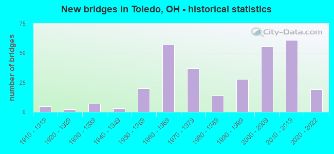
- New bridges - historical statistics
- 51910-1919
- 21920-1929
- 71930-1939
- 31940-1949
- 201950-1959
- 571960-1969
- 371970-1979
- 141980-1989
- 281990-1999
- 562000-2009
- 612010-2019
- 192020-2022

- Reconstructed bridges - Historical Statistics
- 11950-1959
- 01960-1969
- 11970-1979
- 31980-1989
- 111990-1999
- 192000-2009
- 192010-2019
- 52020-2022


- Bridge Condition - Deck
- 32.0%Excellent
- 32.6%Very good
- 23.3%Good
- 7.0%Satisfactory
- 3.5%Fair
- 1.2%Poor
- 0.6%Serious

- Bridge Condition - Superstructure
- 28.2%Excellent
- 26.4%Very good
- 31.6%Good
- 10.9%Satisfactory
- 1.7%Fair
- 1.1%Poor

- Bridge Condition - Substructure
- 25.9%Excellent
- 29.3%Very good
- 33.3%Good
- 10.9%Satisfactory
- 0.6%Poor

- Bridge Condition - Channel
- 24.7%Excellent
- 34.4%Very good
- 24.7%Good
- 12.9%Satisfactory
- 2.2%Fair
- 1.1%Poor

- Bridge Condition - Culverts
- 16.7%Very good
- 55.6%Good
- 27.8%Satisfactory
Find on map >> Show street view
Structure Number: 4861701, Location: E. OF NORTH HAVEN (Lat: 41.704739, Lng: -83.567639), Route carried "on" structure: City street M0344, Year Built: 1976, Status: Open, Structure Length: 0.85m (2.79ft), Average Daily Traffic: 1,007 (year 1994), Truck Traffic: 5%, Average Future Daily Traffic: 1,398 (year 2014), Design Load: HS 20, Features Intersected: SHANTEE CREEK, Facility Carried by Structure: CRIBB STREET
Minimum Vertical Clearance: 30+ m (98+ ft), Kilometerpoint: 9.012, Lanes on structure: 2, Owner: City or Municipal Highway Agency, Approaching Roadway Width: 7.3m (24.0ft), Skew: 6 degrees, Material/Design: Concrete, Design/Construction: Culvert, Number Of Spans In Main Unit: 2, Length of Maximum Span: 3.4m (11.2ft)
Condition: Channel: Good, Culverts: Good, Operating Rating: 42.1 metric tons, Method Used To Determine Operating Rating: Load Factor (LF) rating reported by rating factor (RF) method using MS18 loading, Inventory Rating: 32.4 metric tons, Method Used To Determine Inventory Rating: Load Factor (LF) rating reported by rating factor (RF) method using MS18 loading, Structural Evaluation: Better than present minimum criteria, Waterway Adequacy: Superior to present desirable criteria, Approach Roadway Alignment: Equal to present desirable criteria, Designated Inspection Frequency: Every 24 months, Inspection Date: November 2021
Find on map >> Show street view
Structure Number: 4861728, Location: W. OF NORTH HAVEN (Lat: 41.703800, Lng: -83.569539), Route carried "on" structure: City street M0630, Year Built: 1976, Status: Open, Structure Length: 0.85m (2.79ft), Average Daily Traffic: 798 (year 1995), Truck Traffic: 5%, Average Future Daily Traffic: 1,108 (year 2015), Design Load: HS 20, Features Intersected: SHANTEE CREEK, Facility Carried by Structure: HAWK STREET
Minimum Vertical Clearance: 30+ m (98+ ft), Kilometerpoint: 9.028, Lanes on structure: 2, Owner: City or Municipal Highway Agency, Approaching Roadway Width: 7.3m (24.0ft), Skew: 4 degrees, Material/Design: Concrete, Design/Construction: Culvert, Number Of Spans In Main Unit: 2, Length of Maximum Span: 3.4m (11.2ft)
Condition: Channel: Very good, Culverts: Good, Operating Rating: 42.1 metric tons, Method Used To Determine Operating Rating: Load Factor (LF) rating reported by rating factor (RF) method using MS18 loading, Inventory Rating: 32.4 metric tons, Method Used To Determine Inventory Rating: Load Factor (LF) rating reported by rating factor (RF) method using MS18 loading, Structural Evaluation: Better than present minimum criteria, Waterway Adequacy: Superior to present desirable criteria, Approach Roadway Alignment: Equal to present desirable criteria, Designated Inspection Frequency: Every 24 months, Inspection Date: November 2021
Find on map >> Show street view
Structure Number: 4861761, Location: 165' W OF OTTAWA PARKWAY (Lat: 41.666911, Lng: -83.594261), Route carried "on" structure: City street M2460, Year Built: 2016, Status: Open, Structure Length: 3.05m (10.01ft), Average Daily Traffic: 500 (year 2015), Truck Traffic: 1%, Average Future Daily Traffic: 2,796 (year 2035), Design Load: HL 93, Features Intersected: OTTAWA RIVER, Facility Carried by Structure: EAST CIRCLE LANE
Minimum Vertical Clearance: 30+ m (98+ ft), Kilometerpoint: 9.849, Lanes on structure: 2, Owner: City or Municipal Highway Agency, Approaching Roadway Width: 7.6m (24.9ft), Skew: 1 degrees, Material/Design: Concrete continuous, Design/Construction: Slab, Number Of Spans In Main Unit: 3, Length of Maximum Span: 11.4m (37.4ft), Curb or Sidewalk Widths: Left: 1.8m (5.9ft), Right: 3.3m (10.8ft), Curb-To-Curb Width: 7.3m (24.0ft), Out-to-Out Width: 13.1m (43.0ft)
Condition: Deck: Very good, Superstructure: Very good, Substructure: Excellent, Channel: Excellent, Operating Rating: 58.3 metric tons, Method Used To Determine Operating Rating: Load and Resistance Factor Rating (LRFR) rating reported by rating factor(RF) method using HL-93 loadings, Inventory Rating: 45.4 metric tons, Method Used To Determine Inventory Rating: Load and Resistance Factor Rating (LRFR) rating reported by rating factor(RF) method using HL-93 loadings, Structural Evaluation: Equal to present desirable criteria, Deck Geometry: Meets minimum limits, Waterway Adequacy: Equal to present minimum criteria, Approach Roadway Alignment: Equal to present desirable criteria, Designated Inspection Frequency: Every 24 months, Inspection Date: September 2021, Deck Structure Type: Concrete Cast-file-Place, Wearing Surface/Protective System: Wearing Surface: Monolithic Concrete, Deck Protection: Epoxy Coated Reinforcing
Find on map >> Show street view
Structure Number: 4861949, Location: S. OF LUDDINGTON (Lat: 41.664339, Lng: -83.690450), Route carried "on" structure: City street M2110, Year Built: 1950, Status: Open, Structure Length: 0.67m (2.20ft), Average Daily Traffic: 1,382 (year 1997), Truck Traffic: 2%, Average Future Daily Traffic: 1,918 (year 2017), Design Load: HS 20, Features Intersected: HILL DITCH, Facility Carried by Structure: ORCHARD HILLS BLVD
Minimum Vertical Clearance: 30+ m (98+ ft), Kilometerpoint: 15.595, Lanes on structure: 2, Owner: City or Municipal Highway Agency, Approaching Roadway Width: 7.6m (24.9ft), Skew: 3 degrees, Material/Design: Concrete, Design/Construction: Culvert, Number Of Spans In Main Unit: 3, Length of Maximum Span: 1.8m (5.9ft)
Condition: Channel: Satisfactory, Culverts: Satisfactory, Operating Rating: 42.1 metric tons, Method Used To Determine Operating Rating: Assigned rating based on Load Factor Design (LFD) reported by rating factor (RF) using MS18 loading, Inventory Rating: 32.4 metric tons, Method Used To Determine Inventory Rating: Assigned rating based on Load Factor Design (LFD) reported by rating factor (RF) using MS18 loading, Structural Evaluation: Equal to present minimum criteria, Waterway Adequacy: Equal to present desirable criteria, Approach Roadway Alignment: Equal to present desirable criteria, Designated Inspection Frequency: Every 12 months, Inspection Date: October 2021
Find on map >> Show street view
Structure Number: 8729085, Location: 3.7MI EAST OF EXIT 59 (Lat: 41.577431, Lng: -83.601461), Route carried "on" structure: Interstate 80K, Year Built: 1954, Year Reconstructed: 1987, Status: Open, Structure Length: 5.00m (16.40ft), Average Daily Traffic: 15,824 (year 2015), Truck Traffic: 37%, Average Future Daily Traffic: 21,964 (year 2035), Design Load: HS 20, Features Intersected: SR65, Facility Carried by Structure: I80 OH TPK
Minimum Vertical Clearance: 30+ m (98+ ft), Kilometerpoint: 0.531, Lanes on structure: 2, Lanes under structure: 2, Base Highway Network: Yes, Toll: On toll road, Owner: State Toll Authority, Approaching Roadway Width: 13.4m (44.0ft), Skew: 2 degrees, Material/Design: Steel continuous, Design/Construction: Stringer/Multi-beam, Number Of Spans In Main Unit: 3, Length of Maximum Span: 24.4m (80.1ft), Curb-To-Curb Width: 11.4m (37.4ft), Out-to-Out Width: 12.3m (40.4ft)
Condition: Deck: Good, Superstructure: Very good, Substructure: Very good, Operating Rating: 68.0 metric tons, Method Used To Determine Operating Rating: Load Factor (LF) rating reported by rating factor (RF) method using MS18 loading, Inventory Rating: 42.1 metric tons, Method Used To Determine Inventory Rating: Load Factor (LF) rating reported by rating factor (RF) method using MS18 loading, Structural Evaluation: Equal to present desirable criteria, Deck Geometry: Meets minimum limits, Underclear: Meets minimum limits, Approach Roadway Alignment: Equal to present desirable criteria, Designated Inspection Frequency: Every 24 months, Inspection Date: June 2021, Deck Structure Type: Concrete Cast-file-Place, Wearing Surface/Protective System: Wearing Surface: Monolithic Concrete, Deck Protection: Epoxy Coated Reinforcing
Find on map >> Show street view
Structure Number: 4800249, Location: JCT. SR 2 & IR 75 (Lat: 41.637650, Lng: -83.546769), Route carried "under" structure: City street M1086, Year Built: 1964, Structure Length: 0. m, Average Daily Traffic: 565 (year 0209), Truck Traffic: 23%, Features Intersected: SR 2
Minimum Vertical Clearance: 4.85m (15.91ft), Kilometerpoint: 11.346, Lanes on structure: 4, Lanes under structure: 2, Material/Design: Steel continuous, Design/Construction: Stringer/Multi-beam, Length of Maximum Span: 29.3m (96.1ft)
Find on map >> Show street view
Structure Number: 4800303, Location: 0.2 mile East of Summit (Lat: 41.641889, Lng: -83.539981), Route carried "under" structure: City street M1645, Year Built: 1931, Structure Length: 0. m, Average Daily Traffic: 500 (year 2019), Truck Traffic: 5%, Features Intersected: SR 2
Minimum Vertical Clearance: 4.40m (14.44ft), Kilometerpoint: 0.208, Lanes on structure: 4, Lanes under structure: 13, Material/Design: Steel, Design/Construction: Suspension, Length of Maximum Span: 239.3m (785.1ft)
Find on map >> Show street view
Structure Number: 4800303, Location: 0.2 mile East of Summit (Lat: 41.641889, Lng: -83.539981), Route carried "under" structure: County highway C0557, Year Built: 1931, Structure Length: 0. m, Average Daily Traffic: 7,311 (year 2019), Truck Traffic: 11%, Features Intersected: SR 2
Minimum Vertical Clearance: 15.26m (50.07ft), Kilometerpoint: 1.341, Lanes on structure: 4, Lanes under structure: 13, Material/Design: Steel, Design/Construction: Suspension, Length of Maximum Span: 239.3m (785.1ft)
Find on map >> Show street view
Structure Number: 4800303, Location: 0.2 mile East of Summit (Lat: 41.641889, Lng: -83.539981), Route carried "under" structure: City street M1731, Year Built: 1931, Structure Length: 0. m, Average Daily Traffic: 500 (year 2019), Truck Traffic: 5%, Features Intersected: SR 2
Minimum Vertical Clearance: 11.63m (38.16ft), Kilometerpoint: 0.182, Lanes on structure: 4, Lanes under structure: 13, Material/Design: Steel, Design/Construction: Suspension, Length of Maximum Span: 239.3m (785.1ft)
Find on map >> Show street view
Structure Number: 4800303, Location: 0.2 mile East of Summit (Lat: 41.641889, Lng: -83.539981), Route carried "under" structure: City street M2102, Year Built: 1931, Structure Length: 0. m, Average Daily Traffic: 500 (year 2019), Features Intersected: SR 2
Minimum Vertical Clearance: 4.04m (13.25ft), Kilometerpoint: 1.907, Lanes on structure: 4, Lanes under structure: 13, Material/Design: Steel, Design/Construction: Suspension, Length of Maximum Span: 239.3m (785.1ft)
Find on map >> Show street view
Structure Number: 4800303, Location: 0.2 mile East of Summit (Lat: 41.641889, Lng: -83.539981), Route carried "under" structure: City street M2255, Year Built: 1931, Structure Length: 0. m, Average Daily Traffic: 750 (year 2019), Features Intersected: SR 2
Minimum Vertical Clearance: 3.91m (12.83ft), Kilometerpoint: 1.345, Lanes on structure: 4, Lanes under structure: 13, Material/Design: Steel, Design/Construction: Suspension, Length of Maximum Span: 239.3m (785.1ft)
Find on map >> Show street view
Structure Number: 4800613, Location: JCT. USR 20 AND IR 475 (Lat: 41.674689, Lng: -83.694369), Route carried "under" structure: Interstate 475, Year Built: 2016, Structure Length: 0. m, Average Daily Traffic: 92,002 (year 2019), Truck Traffic: 9%, Features Intersected: USR 20
Minimum Vertical Clearance: 5.03m (16.50ft), Kilometerpoint: 24.591, Lanes on structure: 6, Lanes under structure: 7, Material/Design: Prestressed concrete continuous, Design/Construction: Stringer/Multi-beam, Length of Maximum Span: 27.5m (90.2ft)
Find on map >> Show street view
Structure Number: 4801563, Location: WB SR 25 over Collingwood (Lat: 41.641881, Lng: -83.551581), Route carried "under" structure: City street C0514, Year Built: 1963, Structure Length: 0. m, Average Daily Traffic: 6,499 (year 2019), Truck Traffic: 5%, Features Intersected: SR 25, Facility Carried by Structure: CR 514 Collingwood
Minimum Vertical Clearance: 4.42m (14.50ft), Kilometerpoint: 12.167, Lanes on structure: 2, Lanes under structure: 4, Material/Design: Steel continuous, Design/Construction: Stringer/Multi-beam, Length of Maximum Span: 23.5m (77.1ft)
Find on map >> Show street view
Structure Number: 4801598, Location: EB SR-25 over Collingwood (Lat: 41.641861, Lng: -83.551400), Route carried "under" structure: City street C0514, Year Built: 1963, Structure Length: 0. m, Average Daily Traffic: 6,499 (year 2019), Truck Traffic: 5%, Features Intersected: SR 25
Minimum Vertical Clearance: 4.42m (14.50ft), Kilometerpoint: 11.282, Lanes on structure: 2, Lanes under structure: 2, Material/Design: Steel continuous, Design/Construction: Stringer/Multi-beam, Length of Maximum Span: 23.5m (77.1ft)
Find on map >> Show street view
Structure Number: 480216, Location: .09 MI S OF HILL AVE-US24 (Lat: 41.637500, Lng: -83.591111), Route carried "under" structure: US 24, Year Built: 1912, Structure Length: 0. m, Average Daily Traffic: 19,283 (year 2017), Truck Traffic: 6%, Features Intersected: NS RR PRIVATE RD
Minimum Vertical Clearance: 5.08m (16.67ft), Kilometerpoint: 36.210, Lanes on structure: 4, Lanes under structure: 4, Material/Design: Prestressed concrete, Design/Construction: Box Beam or Girders - Multiple, Length of Maximum Span: 19.7m (64.6ft)
Find on map >> Show street view
Structure Number: 4802373, Location: JCT IR 75 & USR 24 (Lat: 41.666869, Lng: -83.568869), Route carried "under" structure: Interstate 75, Year Built: 1967, Structure Length: 0. m, Average Daily Traffic: 87,560 (year 2010), Truck Traffic: 15%, Features Intersected: USR 24
Minimum Vertical Clearance: 4.65m (15.26ft), Kilometerpoint: 6.421, Lanes on structure: 6, Lanes under structure: 9, Material/Design: Steel continuous, Design/Construction: Stringer/Multi-beam, Length of Maximum Span: 29.0m (95.1ft)
Find on map >> Show street view
Structure Number: 4802706, Location: 750 Ft. S. of Maumee Riv. (Lat: 41.620261, Lng: -83.541189), Route carried "under" structure: State highway 65, Year Built: 2021, Structure Length: 0. m, Average Daily Traffic: 21,504 (year 2019), Truck Traffic: 7%, Features Intersected: IR 75
Minimum Vertical Clearance: 5.11m (16.77ft), Kilometerpoint: 0.602, Lanes on structure: 6, Lanes under structure: 4, Material/Design: Prestressed concrete, Design/Construction: Stringer/Multi-beam, Length of Maximum Span: 26.0m (85.3ft)
Find on map >> Show street view
Structure Number: 4802775, Location: 0.84 MI. N. OF COUNTY LIN (Lat: 41.629711, Lng: -83.542181), Route carried "under" structure: City street C0533, Year Built: 2021, Structure Length: 0. m, Average Daily Traffic: 8,264 (year 2019), Truck Traffic: 7%, Features Intersected: IR 75
Minimum Vertical Clearance: 4.85m (15.91ft), Kilometerpoint: 4.720, Lanes on structure: 3, Lanes under structure: 2, Material/Design: Prestressed concrete, Design/Construction: Stringer/Multi-beam, Length of Maximum Span: 40.2m (131.9ft)
Find on map >> Show street view
Structure Number: 4802854, Location: IR 75 over Segur Ave (Lat: 41.636669, Lng: -83.543889), Route carried "under" structure: City street M1933, Year Built: 2019, Structure Length: 0. m, Average Daily Traffic: 300 (year 2019), Features Intersected: IR 75
Minimum Vertical Clearance: 4.57m (14.99ft), Kilometerpoint: 11.394, Lanes on structure: 8, Lanes under structure: 2, Material/Design: Prestressed concrete, Design/Construction: Stringer/Multi-beam, Length of Maximum Span: 28.6m (93.8ft)
Find on map >> Show street view
Structure Number: 4802889, Location: JCT. SR 2 (Lat: 41.637481, Lng: -83.544719), Route carried "under" structure: State highway 2, Year Built: 2019, Structure Length: 0. m, Average Daily Traffic: 15,000 (year 2019), Truck Traffic: 5%, Features Intersected: IR 75
Minimum Vertical Clearance: 5.17m (16.96ft), Kilometerpoint: 29.290, Lanes on structure: 8, Lanes under structure: 4, Material/Design: Steel continuous, Design/Construction: Stringer/Multi-beam, Length of Maximum Span: 69.9m (229.3ft)
Find on map >> Show street view
Structure Number: 4802889, Location: JCT. SR 2 (Lat: 41.637481, Lng: -83.544719), Route carried "under" structure: City street M1086, Year Built: 2019, Structure Length: 0. m, Average Daily Traffic: 822 (year 2019), Truck Traffic: 17%, Features Intersected: IR 75, Facility Carried by Structure: Emerald Ave.
Minimum Vertical Clearance: 9.45m (31.00ft), Kilometerpoint: 0.819, Lanes on structure: 8, Lanes under structure: 4, Material/Design: Steel continuous, Design/Construction: Stringer/Multi-beam, Length of Maximum Span: 69.9m (229.3ft)
Find on map >> Show street view
Structure Number: 4802943, Location: 1.52 MI. NORTH of SR 65 (Lat: 41.640561, Lng: -83.548061), Route carried "under" structure: City street C0514, Year Built: 2021, Structure Length: 0. m, Average Daily Traffic: 6,499 (year 2019), Truck Traffic: 5%, Features Intersected: IR 75, Facility Carried by Structure: CR 514 COLLINGWOOD
Minimum Vertical Clearance: 8.78m (28.81ft), Kilometerpoint: 0.451, Lanes on structure: 3, Lanes under structure: 14, Material/Design: Steel continuous, Design/Construction: Stringer/Multi-beam, Length of Maximum Span: 61.0m (200.1ft)
Find on map >> Show street view
Structure Number: 4802943, Location: 1.52 MI. NORTH of SR 65 (Lat: 41.640561, Lng: -83.548061), Route carried "under" structure: Ramp State highway 25, Year Built: 2021, Structure Length: 0. m, Average Daily Traffic: 1,505 (year 2019), Truck Traffic: 4%, Features Intersected: IR 75
Minimum Vertical Clearance: 6.49m (21.29ft), Kilometerpoint: 13.657, Lanes on structure: 3, Lanes under structure: 14, Material/Design: Steel continuous, Design/Construction: Stringer/Multi-beam, Length of Maximum Span: 61.0m (200.1ft)
Find on map >> Show street view
Structure Number: 4802943, Location: 1.52 MI. NORTH of SR 65 (Lat: 41.640561, Lng: -83.548061), Route carried "under" structure: Ramp State highway 25, Year Built: 2021, Structure Length: 0. m, Average Daily Traffic: 7,555 (year 2019), Truck Traffic: 7%, Features Intersected: IR 75
Minimum Vertical Clearance: 5.27m (17.29ft), Kilometerpoint: 13.657, Lanes on structure: 3, Lanes under structure: 14, Material/Design: Steel continuous, Design/Construction: Stringer/Multi-beam, Length of Maximum Span: 61.0m (200.1ft)
Find on map >> Show street view
Structure Number: 4802943, Location: 1.52 MI. NORTH of SR 65 (Lat: 41.640561, Lng: -83.548061), Route carried "under" structure: City street C0518, Year Built: 2021, Structure Length: 0. m, Average Daily Traffic: 1,505 (year 2019), Truck Traffic: 4%, Features Intersected: IR 75, Facility Carried by Structure: CR 518 ERIE ST.
Minimum Vertical Clearance: 6.01m (19.72ft), Kilometerpoint: 0.026, Lanes on structure: 3, Lanes under structure: 14, Material/Design: Steel continuous, Design/Construction: Stringer/Multi-beam, Length of Maximum Span: 61.0m (200.1ft)
Find on map >> Show street view
Structure Number: 4802943, Location: 1.52 MI. NORTH of SR 65 (Lat: 41.640561, Lng: -83.548061), Route carried "under" structure: State highway 25, Year Built: 2021, Structure Length: 0. m, Average Daily Traffic: 24,316 (year 2019), Truck Traffic: 4%, Features Intersected: IR 75
Minimum Vertical Clearance: 7.50m (24.61ft), Kilometerpoint: 13.657, Lanes on structure: 3, Lanes under structure: 14, Material/Design: Steel continuous, Design/Construction: Stringer/Multi-beam, Length of Maximum Span: 61.0m (200.1ft)
Find on map >> Show street view
Structure Number: 4802944, Location: 1.52 MILES NORTH SR 65 (Lat: 41.640719, Lng: -83.548150), Route carried "under" structure: Ramp State highway 25, Year Built: 2021, Structure Length: 0. m, Average Daily Traffic: 7,555 (year 2019), Truck Traffic: 7%, Features Intersected: IR 75
Minimum Vertical Clearance: 6.19m (20.31ft), Kilometerpoint: 13.691, Lanes on structure: 3, Lanes under structure: 14, Material/Design: Steel continuous, Design/Construction: Stringer/Multi-beam, Length of Maximum Span: 60.8m (199.5ft)
Find on map >> Show street view
Structure Number: 4802944, Location: 1.52 MILES NORTH SR 65 (Lat: 41.640719, Lng: -83.548150), Route carried "under" structure: Ramp State highway 25, Year Built: 2021, Structure Length: 0. m, Average Daily Traffic: 1,505 (year 2019), Truck Traffic: 4%, Features Intersected: IR 75
Minimum Vertical Clearance: 4.72m (15.49ft), Kilometerpoint: 13.691, Lanes on structure: 3, Lanes under structure: 14, Material/Design: Steel continuous, Design/Construction: Stringer/Multi-beam, Length of Maximum Span: 60.8m (199.5ft)
Find on map >> Show street view
Structure Number: 4802944, Location: 1.52 MILES NORTH SR 65 (Lat: 41.640719, Lng: -83.548150), Route carried "under" structure: State highway 25, Year Built: 2021, Structure Length: 0. m, Average Daily Traffic: 24,316 (year 2019), Truck Traffic: 4%, Features Intersected: IR 75
Minimum Vertical Clearance: 6.93m (22.74ft), Kilometerpoint: 13.691, Lanes on structure: 3, Lanes under structure: 14, Material/Design: Steel continuous, Design/Construction: Stringer/Multi-beam, Length of Maximum Span: 60.8m (199.5ft)
Find on map >> Show street view
Structure Number: 4802944, Location: 1.52 MILES NORTH SR 65 (Lat: 41.640719, Lng: -83.548150), Route carried "under" structure: City street C0518, Year Built: 2021, Structure Length: 0. m, Average Daily Traffic: 1,505 (year 2019), Truck Traffic: 4%, Features Intersected: IR 75, Facility Carried by Structure: CR 518 ERIE ST.
Minimum Vertical Clearance: 5.30m (17.39ft), Kilometerpoint: 0.051, Lanes on structure: 3, Lanes under structure: 14, Material/Design: Steel continuous, Design/Construction: Stringer/Multi-beam, Length of Maximum Span: 60.8m (199.5ft)
Find on map >> Show street view
Structure Number: 4802944, Location: 1.52 MILES NORTH SR 65 (Lat: 41.640719, Lng: -83.548150), Route carried "under" structure: City street C0514, Year Built: 2021, Structure Length: 0. m, Average Daily Traffic: 6,499 (year 2019), Truck Traffic: 5%, Features Intersected: IR 75, Facility Carried by Structure: CR 514 COLLINGWOOD
Minimum Vertical Clearance: 8.08m (26.51ft), Kilometerpoint: 0.443, Lanes on structure: 3, Lanes under structure: 14, Material/Design: Steel continuous, Design/Construction: Stringer/Multi-beam, Length of Maximum Span: 60.8m (199.5ft)
Find on map >> Show street view
Structure Number: 4803095, Location: IR 75 UNDER INDIANA AVE. (Lat: 41.650361, Lng: -83.549050), Route carried "under" structure: Interstate 75, Year Built: 2018, Structure Length: 0. m, Average Daily Traffic: 112,610 (year 2018), Truck Traffic: 23%, Features Intersected: INDIANA AVE
Minimum Vertical Clearance: 4.92m (16.14ft), Kilometerpoint: 3.766, Lanes on structure: 2, Lanes under structure: 5, Material/Design: Prestressed concrete continuous, Design/Construction: Stringer/Multi-beam, Length of Maximum Span: 30.5m (100.1ft)
Find on map >> Show street view
Structure Number: 4803159, Location: I-75 under Collingwood (Lat: 41.654711, Lng: -83.554861), Route carried "under" structure: Interstate 75, Year Built: 1968, Structure Length: 0. m, Average Daily Traffic: 84,445 (year 2018), Truck Traffic: 22%, Features Intersected: COLLINGWOOD AVE
Minimum Vertical Clearance: 4.80m (15.75ft), Kilometerpoint: 4.506, Lanes on structure: 4, Lanes under structure: 8, Material/Design: Steel continuous, Design/Construction: Stringer/Multi-beam, Length of Maximum Span: 27.4m (89.9ft)
Find on map >> Show street view
Structure Number: 4803183, Location: I-75 under Oakwood Ave. (Lat: 41.656619, Lng: -83.559350), Route carried "under" structure: Interstate 75, Year Built: 1968, Structure Length: 0. m, Average Daily Traffic: 90,000 (year 2018), Truck Traffic: 22%, Features Intersected: OAKWOOD AVE
Minimum Vertical Clearance: 4.60m (15.09ft), Kilometerpoint: 4.844, Lanes on structure: 2, Lanes under structure: 8, Material/Design: Steel continuous, Design/Construction: Stringer/Multi-beam, Length of Maximum Span: 58.2m (190.9ft)
Find on map >> Show street view
Structure Number: 4803213, Location: I-75 under Lincoln Ave. (Lat: 41.657500, Lng: -83.561561), Route carried "under" structure: Interstate 75, Year Built: 1969, Structure Length: 0. m, Average Daily Traffic: 90,000 (year 2018), Truck Traffic: 22%, Features Intersected: LINCOLN AVE
Minimum Vertical Clearance: 4.72m (15.49ft), Kilometerpoint: 5.053, Lanes on structure: 2, Lanes under structure: 9, Material/Design: Steel continuous, Design/Construction: Stringer/Multi-beam, Length of Maximum Span: 47.5m (155.8ft)
Find on map >> Show street view
Structure Number: 4803272, Location: I-75 under Bancroft St. (Lat: 41.663750, Lng: -83.564339), Route carried "under" structure: Interstate 75, Year Built: 1969, Structure Length: 0. m, Average Daily Traffic: 85,337 (year 2018), Truck Traffic: 22%, Features Intersected: BANCROFT ST
Minimum Vertical Clearance: 5.41m (17.75ft), Kilometerpoint: 5.858, Lanes on structure: 3, Lanes under structure: 8, Material/Design: Steel continuous, Design/Construction: Stringer/Multi-beam, Length of Maximum Span: 23.8m (78.1ft)
Find on map >> Show street view
Structure Number: 4803361, Location: I-75 under Delaware Ave. (Lat: 41.670831, Lng: -83.573031), Route carried "under" structure: Interstate 75, Year Built: 1969, Structure Length: 0. m, Average Daily Traffic: 85,958 (year 2018), Truck Traffic: 22%, Features Intersected: DELAWARE AVE
Minimum Vertical Clearance: 4.95m (16.24ft), Kilometerpoint: 6.985, Lanes on structure: 2, Lanes under structure: 8, Material/Design: Steel continuous, Design/Construction: Stringer/Multi-beam, Length of Maximum Span: 32.3m (106.0ft)
Find on map >> Show street view
Structure Number: 4803418, Location: JCT. IR 475/IR 75 (Lat: 41.674550, Lng: -83.573919), Route carried "under" structure: Ramp Interstate 475, Year Built: 2016, Structure Length: 0. m, Average Daily Traffic: 26,060 (year 2010), Truck Traffic: 17%, Features Intersected: IR 75 SB
Minimum Vertical Clearance: 5.20m (17.06ft), Kilometerpoint: 7.419, Lanes on structure: 2, Lanes under structure: 2, Material/Design: Steel continuous, Design/Construction: Stringer/Multi-beam, Length of Maximum Span: 37.1m (121.7ft)
Find on map >> Show street view
Structure Number: 4803671, Location: I-75 over Willys Parkway (Lat: 41.681981, Lng: -83.571469), Route carried "under" structure: Ramp Interstate 75, Year Built: 2018, Structure Length: 0. m, Average Daily Traffic: 8,632 (year 2014), Truck Traffic: 4%, Features Intersected: IR 75 SB RAMP, Facility Carried by Structure: WILLYS RAMP TO SB
Minimum Vertical Clearance: 5.34m (17.52ft), Kilometerpoint: 8.240, Lanes on structure: 2, Lanes under structure: 1, Material/Design: Prestressed concrete, Design/Construction: Stringer/Multi-beam, Length of Maximum Span: 24.8m (81.4ft)
Find on map >> Show street view
Structure Number: 4803701, Location: JCT. IR 75/WILLYS PKWY (Lat: 41.683331, Lng: -83.570281), Route carried "under" structure: City street C2230, Year Built: 2017, Structure Length: 0. m, Average Daily Traffic: 9,370 (year 2014), Truck Traffic: 2%, Features Intersected: IR 75, Facility Carried by Structure: WILLYS PKWY
Minimum Vertical Clearance: 5.37m (17.62ft), Kilometerpoint: 0.085, Lanes on structure: 2, Lanes under structure: 2, Material/Design: Prestressed concrete, Design/Construction: Stringer/Multi-beam, Length of Maximum Span: 32.9m (107.9ft)
Find on map >> Show street view
Structure Number: 4803744, Location: JCT. IR 75/WILLYS PKWY (Lat: 41.682781, Lng: -83.569719), Route carried "under" structure: City street C2230, Year Built: 2017, Structure Length: 0. m, Average Daily Traffic: 9,370 (year 2014), Truck Traffic: 2%, Features Intersected: IR 75, Facility Carried by Structure: WILLYS PARKWAY
Minimum Vertical Clearance: 5.37m (17.62ft), Kilometerpoint: 8.369, Lanes on structure: 4, Lanes under structure: 2, Material/Design: Prestressed concrete, Design/Construction: Stringer/Multi-beam, Length of Maximum Span: 33.0m (108.3ft)
Find on map >> Show street view
Structure Number: 480376, Location: JCT I-75 and WILLYS PKWY (Lat: 41.683331, Lng: -83.570831), Route carried "under" structure: City street C2230, Year Built: 2018, Structure Length: 0. m, Average Daily Traffic: 9,370 (year 2014), Truck Traffic: 2%, Features Intersected: IR 75 Ramp, Facility Carried by Structure: WILLYS PARKWAY
Minimum Vertical Clearance: 5.31m (17.42ft), Kilometerpoint: 8.369, Lanes on structure: 2, Lanes under structure: 2, Material/Design: Prestressed concrete, Design/Construction: Stringer/Multi-beam, Length of Maximum Span: 32.9m (107.9ft)
Find on map >> Show street view
Structure Number: 4803787, Location: 0.2 MI E INT USR24 & IR75 (Lat: 41.686931, Lng: -83.552139), Route carried "under" structure: City street C0510, Year Built: 1970, Structure Length: 0. m, Average Daily Traffic: 11,296 (year 2015), Truck Traffic: 7%, Features Intersected: IR 75, Facility Carried by Structure: Phillips Ave.
Minimum Vertical Clearance: 5.08m (16.67ft), Kilometerpoint: 6.550, Lanes on structure: 4, Lanes under structure: 4, Material/Design: Steel continuous, Design/Construction: Stringer/Multi-beam, Length of Maximum Span: 24.4m (80.1ft)
Find on map >> Show street view
Structure Number: 4803795, Location: 1.05 Mi. N. of I-475 (Lat: 41.688461, Lng: -83.562381), Route carried "under" structure: US 24, Year Built: 2018, Structure Length: 0. m, Average Daily Traffic: 16,400 (year 2014), Truck Traffic: 8%, Features Intersected: IR 75
Minimum Vertical Clearance: 7.41m (24.31ft), Kilometerpoint: 42.678, Lanes on structure: 4, Lanes under structure: 6, Material/Design: Prestressed concrete continuous, Design/Construction: Stringer/Multi-beam, Length of Maximum Span: 48.9m (160.4ft)
Find on map >> Show street view
Structure Number: 4803795, Location: 1.05 Mi. N. of I-475 (Lat: 41.688461, Lng: -83.562381), Route carried "under" structure: County highway C0500, Year Built: 2018, Structure Length: 0. m, Average Daily Traffic: 20,840 (year 2014), Truck Traffic: 2%, Features Intersected: IR 75, Facility Carried by Structure: CR 500 BERDAN AVE.
Minimum Vertical Clearance: 5.83m (19.13ft), Kilometerpoint: 9.447, Lanes on structure: 4, Lanes under structure: 6, Material/Design: Prestressed concrete continuous, Design/Construction: Stringer/Multi-beam, Length of Maximum Span: 48.9m (160.4ft)
Find on map >> Show street view
Structure Number: 4803809, Location: 1.05 MI. N of I-475 (Lat: 41.688369, Lng: -83.562219), Route carried "under" structure: County highway C0500, Year Built: 2016, Structure Length: 0. m, Average Daily Traffic: 20,840 (year 2014), Truck Traffic: 2%, Features Intersected: IR 75, Facility Carried by Structure: CR 500 BERDAN AVE.
Minimum Vertical Clearance: 5.83m (19.13ft), Kilometerpoint: 9.415, Lanes on structure: 4, Lanes under structure: 8, Material/Design: Prestressed concrete continuous, Design/Construction: Stringer/Multi-beam, Length of Maximum Span: 48.9m (160.4ft)
Find on map >> Show street view
Structure Number: 4803809, Location: 1.05 MI. N of I-475 (Lat: 41.688369, Lng: -83.562219), Route carried "under" structure: US 24, Year Built: 2016, Structure Length: 0. m, Average Daily Traffic: 16,400 (year 2014), Truck Traffic: 8%, Features Intersected: IR 75
Minimum Vertical Clearance: 7.41m (24.31ft), Kilometerpoint: 42.644, Lanes on structure: 4, Lanes under structure: 8, Material/Design: Prestressed concrete continuous, Design/Construction: Stringer/Multi-beam, Length of Maximum Span: 48.9m (160.4ft)
Find on map >> Show street view
Structure Number: 4803876, Location: I-75 over Lagrange St. (Lat: 41.688669, Lng: -83.544931), Route carried "under" structure: City street C0506, Year Built: 1970, Structure Length: 0. m, Average Daily Traffic: 7,616 (year 2015), Truck Traffic: 7%, Features Intersected: IR 75, Facility Carried by Structure: LAGRANGE ST.
Minimum Vertical Clearance: 5.14m (16.86ft), Kilometerpoint: 6.582, Lanes on structure: 6, Lanes under structure: 5, Material/Design: Steel continuous, Design/Construction: Stringer/Multi-beam, Length of Maximum Span: 21.3m (69.9ft)
Find on map >> Show street view
Structure Number: 4803973, Location: 0.5 Mi. E. of LaGrange St (Lat: 41.689269, Lng: -83.534469), Route carried "under" structure: Interstate 75, Year Built: 2017, Structure Length: 0. m, Average Daily Traffic: 79,462 (year 2019), Truck Traffic: 23%, Features Intersected: Polish Village Overpass
Minimum Vertical Clearance: 5.18m (16.99ft), Kilometerpoint: 11.652, Lanes on structure: 2, Lanes under structure: 6, Material/Design: Steel continuous, Design/Construction: Stringer/Multi-beam, Length of Maximum Span: 21.3m (69.9ft)
Find on map >> Show street view
Structure Number: 4804058, Location: IR 75 over Stickney Ave. (Lat: 41.689850, Lng: -83.527239), Route carried "under" structure: City street M0169, Year Built: 1967, Structure Length: 0. m, Average Daily Traffic: 11,003 (year 2019), Truck Traffic: 3%, Features Intersected: IR 75, Facility Carried by Structure: Stickey Ave.
Minimum Vertical Clearance: 4.47m (14.67ft), Kilometerpoint: 6.630, Lanes on structure: 8, Lanes under structure: 5, Material/Design: Steel continuous, Design/Construction: Stringer/Multi-beam, Length of Maximum Span: 25.0m (82.0ft)
Find on map >> Show street view
Structure Number: 4804279, Location: JCT. IR 75 & IR 280 (Lat: 41.690131, Lng: -83.518519), Route carried "under" structure: Interstate 280, Year Built: 2016, Structure Length: 0. m, Average Daily Traffic: 14,040 (year 2018), Truck Traffic: 14%, Features Intersected: IR 75
Minimum Vertical Clearance: 5.03m (16.50ft), Kilometerpoint: 12.987, Lanes on structure: 4, Lanes under structure: 1, Material/Design: Steel, Design/Construction: Stringer/Multi-beam, Length of Maximum Span: 45.7m (149.9ft)
Find on map >> Show street view
Structure Number: 4804333, Location: JCT. IR 75 & IR 280 (Lat: 41.690231, Lng: -83.516731), Route carried "under" structure: Interstate 280, Year Built: 2016, Structure Length: 0. m, Average Daily Traffic: 14,347 (year 2017), Truck Traffic: 29%, Features Intersected: IR 75
Minimum Vertical Clearance: 5.33m (17.49ft), Kilometerpoint: 13.148, Lanes on structure: 4, Lanes under structure: 1, Material/Design: Steel, Design/Construction: Stringer/Multi-beam, Length of Maximum Span: 36.6m (120.1ft)
Find on map >> Show street view
Structure Number: 4804414, Location: 1/4 MI N OF JCT IR 280 (Lat: 41.691411, Lng: -83.510669), Route carried "under" structure: County highway C2240, Year Built: 1957, Structure Length: 0. m, Average Daily Traffic: 4,735 (year 2018), Truck Traffic: 7%, Features Intersected: IR 75, Facility Carried by Structure: CR 2240 CHRYSLER
Minimum Vertical Clearance: 6.76m (22.18ft), Kilometerpoint: 0.409, Lanes on structure: 7, Lanes under structure: 5, Material/Design: Steel continuous, Design/Construction: Stringer/Multi-beam, Length of Maximum Span: 28.7m (94.2ft)
Find on map >> Show street view
Structure Number: 4804473, Location: 1/2 MI W. OF JCT IR 280 (Lat: 41.691789, Lng: -83.508481), Route carried "under" structure: City street M1336, Year Built: 1957, Structure Length: 0. m, Average Daily Traffic: 300 (year 1974), Features Intersected: IR 75
Minimum Vertical Clearance: 6.65m (21.82ft), Kilometerpoint: 0.441, Lanes on structure: 7, Lanes under structure: 2, Material/Design: Steel continuous, Design/Construction: Stringer/Multi-beam, Length of Maximum Span: 27.4m (89.9ft)
Find on map >> Show street view
Structure Number: 4804678, Location: 150 YDS W JCT SUDER AVE (Lat: 41.706461, Lng: -83.501939), Route carried "under" structure: Interstate 75, Year Built: 1997, Structure Length: 0. m, Average Daily Traffic: 64,045 (year 2019), Truck Traffic: 23%, Features Intersected: OTTAWA RIVER ROAD RAMP
Minimum Vertical Clearance: 5.05m (16.57ft), Kilometerpoint: 15.804, Lanes on structure: 1, Lanes under structure: 6, Material/Design: Steel continuous, Design/Construction: Stringer/Multi-beam, Length of Maximum Span: 43.3m (142.1ft)
Find on map >> Show street view
Structure Number: 4804724, Location: 100 YDS. WEST OF SUDER (Lat: 41.712661, Lng: -83.501611), Route carried "under" structure: Interstate 75, Year Built: 1997, Structure Length: 0. m, Average Daily Traffic: 60,874 (year 2010), Truck Traffic: 31%, Features Intersected: BENORE ROAD
Minimum Vertical Clearance: 5.79m (19.00ft), Kilometerpoint: 16.447, Lanes on structure: 4, Lanes under structure: 6, Material/Design: Steel continuous, Design/Construction: Stringer/Multi-beam, Length of Maximum Span: 36.0m (118.1ft)
Find on map >> Show street view
Structure Number: 4804759, Location: 1/4 MI N ALEXIS RD INTER (Lat: 41.725639, Lng: -83.495331), Route carried "under" structure: Interstate 75, Year Built: 1998, Structure Length: 0. m, Average Daily Traffic: 54,240 (year 2010), Truck Traffic: 32%, Features Intersected: SUDER AVENUE
Minimum Vertical Clearance: 5.01m (16.44ft), Kilometerpoint: 18.153, Lanes on structure: 4, Lanes under structure: 6, Material/Design: Steel continuous, Design/Construction: Stringer/Multi-beam, Length of Maximum Span: 37.8m (124.0ft)
Find on map >> Show street view
Structure Number: 4805038, Location: JCT IR 75 (Lat: 41.678000, Lng: -83.573750), Route carried "under" structure: Interstate 75, Year Built: 2009, Structure Length: 0. m, Average Daily Traffic: 92,832 (year 2015), Truck Traffic: 15%, Features Intersected: SR 120
Minimum Vertical Clearance: 5.47m (17.95ft), Kilometerpoint: 7.805, Lanes on structure: 5, Lanes under structure: 8, Material/Design: Steel continuous, Design/Construction: Stringer/Multi-beam, Length of Maximum Span: 49.1m (161.1ft)
Find on map >> Show street view
Structure Number: 4805127, Location: JCT. SR 184/STICKNEY AVE (Lat: 41.722539, Lng: -83.529269), Route carried "under" structure: City street C0169, Year Built: 1975, Structure Length: 0. m, Average Daily Traffic: 2,414 (year 2019), Truck Traffic: 3%, Features Intersected: SR 184
Minimum Vertical Clearance: 7.75m (25.43ft), Kilometerpoint: 7.451, Lanes on structure: 4, Lanes under structure: 2, Material/Design: Steel continuous, Design/Construction: Stringer/Multi-beam, Length of Maximum Span: 24.4m (80.1ft)
Find on map >> Show street view
Structure Number: 4805178, Location: 0.5 MI S SUDER AVE & IR75 (Lat: 41.721431, Lng: -83.501300), Route carried "under" structure: Interstate 75, Year Built: 1975, Structure Length: 0. m, Average Daily Traffic: 64,045 (year 2019), Truck Traffic: 23%, Features Intersected: SR 184
Minimum Vertical Clearance: 4.98m (16.34ft), Kilometerpoint: 17.429, Lanes on structure: 4, Lanes under structure: 4, Material/Design: Steel continuous, Design/Construction: Stringer/Multi-beam, Length of Maximum Span: 18.9m (62.0ft)
Find on map >> Show street view
Structure Number: 4805259, Location: Monroe SR 51 over IR 475 (Lat: 41.685281, Lng: -83.614039), Route carried "under" structure: Interstate 475, Year Built: 1970, Structure Length: 0. m, Average Daily Traffic: 75,286 (year 2019), Truck Traffic: 9%, Features Intersected: SR 51 MONROE ST.
Minimum Vertical Clearance: 5.21m (17.09ft), Kilometerpoint: 22.499, Lanes on structure: 4, Lanes under structure: 4, Material/Design: Steel continuous, Design/Construction: Stringer/Multi-beam, Length of Maximum Span: 25.3m (83.0ft)
Find on map >> Show street view
Structure Number: 4805372, Location: Monroe St SR-51 over I-75 (Lat: 41.661419, Lng: -83.563661), Route carried "under" structure: Interstate 75, Year Built: 1967, Structure Length: 0. m, Average Daily Traffic: 96,886 (year 2015), Truck Traffic: 14%, Features Intersected: SR 51
Minimum Vertical Clearance: 4.65m (15.26ft), Kilometerpoint: 5.617, Lanes on structure: 4, Lanes under structure: 8, Material/Design: Steel continuous, Design/Construction: Stringer/Multi-beam, Length of Maximum Span: 27.4m (89.9ft)
Find on map >> Show street view
Structure Number: 4805497, Location: DORR ST. OVER IR 75 (Lat: 41.652969, Lng: -83.552100), Route carried "under" structure: Interstate 75, Year Built: 2019, Structure Length: 0. m, Average Daily Traffic: 112,610 (year 2018), Truck Traffic: 12%, Features Intersected: SR 246 Dorr St.
Minimum Vertical Clearance: 4.72m (15.49ft), Kilometerpoint: 4.104, Lanes on structure: 3, Lanes under structure: 8, Material/Design: Steel continuous, Design/Construction: Stringer/Multi-beam, Length of Maximum Span: 51.1m (167.7ft)
Find on map >> Show street view
Structure Number: 4805739, Location: 1.1 MI SE OF SR 65 (Lat: 41.643561, Lng: -83.497750), Route carried "under" structure: County highway C0555, Year Built: 1957, Structure Length: 0. m, Average Daily Traffic: 9,226 (year 2019), Truck Traffic: 3%, Features Intersected: IR 280, Facility Carried by Structure: CR 555 Starr Ave.
Minimum Vertical Clearance: 4.44m (14.57ft), Kilometerpoint: 1.754, Lanes on structure: 6, Lanes under structure: 2, Material/Design: Steel, Design/Construction: Stringer/Multi-beam, Length of Maximum Span: 25.0m (82.0ft)
Find on map >> Show street view
Structure Number: 4805763, Location: 0.60 MI SE OF SR 65 (Lat: 41.650111, Lng: -83.501850), Route carried "under" structure: County highway 525, Year Built: 1957, Structure Length: 0. m, Average Daily Traffic: 2,758 (year 2019), Truck Traffic: 2%, Features Intersected: IR 280
Minimum Vertical Clearance: 4.65m (15.26ft), Kilometerpoint: 2.414, Lanes on structure: 8, Lanes under structure: 2, Material/Design: Steel, Design/Construction: Stringer/Multi-beam, Length of Maximum Span: 17.4m (57.1ft)
Find on map >> Show street view
Structure Number: 4805836, Location: S. SB APPR SPAN TO VGCS (Lat: 41.652269, Lng: -83.503689), Route carried "under" structure: Ramp Interstate 280, Year Built: 2007, Structure Length: 0. m, Average Daily Traffic: 4,070 (year 2019), Truck Traffic: 11%, Features Intersected: IR 280 SB
Minimum Vertical Clearance: 6.99m (22.93ft), Kilometerpoint: 9.093, Lanes on structure: 3, Lanes under structure: 2, Material/Design: Concrete continuous, Design/Construction: Box Beam or Girders - Multiple, Length of Maximum Span: 45.7m (149.9ft)
Find on map >> Show street view
Structure Number: 4805844, Location: S. NB APPR SPAN TO VGCS (Lat: 41.651589, Lng: -83.503211), Route carried "under" structure: State highway 65, Year Built: 2007, Structure Length: 0. m, Average Daily Traffic: 13,189 (year 2019), Truck Traffic: 10%, Features Intersected: IR 280 NB
Minimum Vertical Clearance: 12.19m (39.99ft), Kilometerpoint: 9.344, Lanes on structure: 3, Lanes under structure: 2, Material/Design: Concrete continuous, Design/Construction: Box Beam or Girders - Multiple, Length of Maximum Span: 45.7m (149.9ft)
Find on map >> Show street view
Structure Number: 4805844, Location: S. NB APPR SPAN TO VGCS (Lat: 41.651589, Lng: -83.503211), Route carried "under" structure: Ramp Interstate 280, Year Built: 2007, Structure Length: 0. m, Average Daily Traffic: 4,070 (year 2019), Truck Traffic: 11%, Features Intersected: IR 280 NB
Minimum Vertical Clearance: 6.40m (21.00ft), Kilometerpoint: 9.093, Lanes on structure: 3, Lanes under structure: 2, Material/Design: Concrete continuous, Design/Construction: Box Beam or Girders - Multiple, Length of Maximum Span: 45.7m (149.9ft)
Find on map >> Show street view
Structure Number: 480586, Location: RAMP A,SB,FROM GREENBELT (Lat: 41.669761, Lng: -83.515261), Route carried "under" structure: City street C7008, Year Built: 2007, Structure Length: 0. m, Average Daily Traffic: 565 (year 2019), Truck Traffic: 55%, Features Intersected: IR 280 RAMP A
Minimum Vertical Clearance: 7.32m (24.02ft), Kilometerpoint: 2.583, Lanes on structure: 1, Lanes under structure: 2, Material/Design: Concrete continuous, Design/Construction: Box Beam or Girders - Multiple, Length of Maximum Span: 45.7m (149.9ft)
Find on map >> Show street view
Structure Number: 480586, Location: RAMP A,SB,FROM GREENBELT (Lat: 41.669761, Lng: -83.515261), Route carried "under" structure: City street C0577, Year Built: 2007, Structure Length: 0. m, Average Daily Traffic: 920 (year 2019), Truck Traffic: 14%, Features Intersected: IR 280 RAMP A
Minimum Vertical Clearance: 7.19m (23.59ft), Kilometerpoint: 1.819, Lanes on structure: 1, Lanes under structure: 2, Material/Design: Concrete continuous, Design/Construction: Box Beam or Girders - Multiple, Length of Maximum Span: 45.7m (149.9ft)
Find on map >> Show street view
Structure Number: 4805879, Location: RAMP D TO GALENA ST. (Lat: 41.670889, Lng: -83.514681), Route carried "under" structure: City street C0577, Year Built: 2007, Structure Length: 0. m, Average Daily Traffic: 920 (year 2019), Truck Traffic: 14%, Features Intersected: IR 280 RAMP D, Facility Carried by Structure: CHAMPLAIN ST.
Minimum Vertical Clearance: 7.22m (23.69ft), Kilometerpoint: 1.917, Lanes on structure: 1, Lanes under structure: 2, Material/Design: Concrete continuous, Design/Construction: Box Beam or Girders - Multiple, Length of Maximum Span: 45.1m (148.0ft)
Find on map >> Show street view
Structure Number: 4805992, Location: NB RAMP Y FROM FRONT ST (Lat: 41.655000, Lng: -83.502789), Route carried "under" structure: Ramp Interstate 280, Year Built: 2007, Structure Length: 0. m, Average Daily Traffic: 3,869 (year 2019), Truck Traffic: 9%, Features Intersected: IR 280 RAMP Y
Minimum Vertical Clearance: 7.52m (24.67ft), Kilometerpoint: 0.517, Lanes on structure: 1, Lanes under structure: 1, Material/Design: Concrete continuous, Design/Construction: Box Beam or Girders - Multiple, Length of Maximum Span: 34.1m (111.9ft)
Find on map >> Show street view
Structure Number: 4806018, Location: SB RMP Z TO SR 65/FRNT ST (Lat: 41.656919, Lng: -83.509150), Route carried "under" structure: Ramp Interstate 280, Year Built: 2007, Structure Length: 0. m, Average Daily Traffic: 3,869 (year 2019), Truck Traffic: 9%, Features Intersected: IR 280 RAMP Z
Minimum Vertical Clearance: 7.52m (24.67ft), Kilometerpoint: 5.118, Lanes on structure: 1, Lanes under structure: 2, Material/Design: Concrete continuous, Design/Construction: Box Beam or Girders - Multiple, Length of Maximum Span: 44.8m (147.0ft)
Find on map >> Show street view
Structure Number: 4806018, Location: SB RMP Z TO SR 65/FRNT ST (Lat: 41.656919, Lng: -83.509150), Route carried "under" structure: Ramp Interstate 280, Year Built: 2007, Structure Length: 0. m, Average Daily Traffic: 4,087 (year 2019), Truck Traffic: 9%, Features Intersected: IR 280 RAMP Z
Minimum Vertical Clearance: 7.52m (24.67ft), Kilometerpoint: 5.134, Lanes on structure: 1, Lanes under structure: 2, Material/Design: Concrete continuous, Design/Construction: Box Beam or Girders - Multiple, Length of Maximum Span: 44.8m (147.0ft)
Find on map >> Show street view
Structure Number: 4806107, Location: N.NB.APPR.SPAN TO VGCS. (Lat: 41.663050, Lng: -83.513150), Route carried "under" structure: City street C7008, Year Built: 2007, Structure Length: 0. m, Average Daily Traffic: 565 (year 2019), Truck Traffic: 55%, Features Intersected: IR 280 NB
Minimum Vertical Clearance: 10.21m (33.50ft), Kilometerpoint: 2.092, Lanes on structure: 3, Lanes under structure: 2, Material/Design: Concrete continuous, Design/Construction: Box Beam or Girders - Multiple, Length of Maximum Span: 46.0m (150.9ft)
Find on map >> Show street view
Structure Number: 4806107, Location: N.NB.APPR.SPAN TO VGCS. (Lat: 41.663050, Lng: -83.513150), Route carried "under" structure: City street M3685, Year Built: 2007, Structure Length: 0. m, Average Daily Traffic: 750 (year 2019), Truck Traffic: 4%, Features Intersected: IR 280 NB
Minimum Vertical Clearance: 11.81m (38.75ft), Kilometerpoint: 1.320, Lanes on structure: 3, Lanes under structure: 2, Material/Design: Concrete continuous, Design/Construction: Box Beam or Girders - Multiple, Length of Maximum Span: 46.0m (150.9ft)
Find on map >> Show street view
Structure Number: 4806107, Location: N.NB.APPR.SPAN TO VGCS. (Lat: 41.663050, Lng: -83.513150), Route carried "under" structure: City street C7007, Year Built: 2007, Structure Length: 0. m, Average Daily Traffic: 553 (year 2019), Truck Traffic: 9%, Features Intersected: IR 280 NB
Minimum Vertical Clearance: 11.74m (38.52ft), Kilometerpoint: 0.328, Lanes on structure: 3, Lanes under structure: 2, Material/Design: Concrete continuous, Design/Construction: Box Beam or Girders - Multiple, Length of Maximum Span: 46.0m (150.9ft)
Find on map >> Show street view
Structure Number: 4806107, Location: N.NB.APPR.SPAN TO VGCS. (Lat: 41.663050, Lng: -83.513150), Route carried "under" structure: City street M1720, Year Built: 2007, Structure Length: 0. m, Average Daily Traffic: 1,789 (year 2019), Truck Traffic: 2%, Features Intersected: IR 280 NB
Minimum Vertical Clearance: 11.13m (36.52ft), Kilometerpoint: 2.623, Lanes on structure: 3, Lanes under structure: 2, Material/Design: Concrete continuous, Design/Construction: Box Beam or Girders - Multiple, Length of Maximum Span: 46.0m (150.9ft)
Find on map >> Show street view
Structure Number: 4806107, Location: N.NB.APPR.SPAN TO VGCS. (Lat: 41.663050, Lng: -83.513150), Route carried "under" structure: City street C1980, Year Built: 2007, Structure Length: 0. m, Average Daily Traffic: 7,231 (year 2019), Truck Traffic: 5%, Features Intersected: IR 280 NB
Minimum Vertical Clearance: 13.87m (45.51ft), Kilometerpoint: 12.826, Lanes on structure: 3, Lanes under structure: 2, Material/Design: Concrete continuous, Design/Construction: Box Beam or Girders - Multiple, Length of Maximum Span: 46.0m (150.9ft)
Find on map >> Show street view
Structure Number: 4806107, Location: N.NB.APPR.SPAN TO VGCS. (Lat: 41.663050, Lng: -83.513150), Route carried "under" structure: City street C0577, Year Built: 2007, Structure Length: 0. m, Average Daily Traffic: 920 (year 2019), Truck Traffic: 14%, Features Intersected: IR 280 NB
Minimum Vertical Clearance: 8.69m (28.51ft), Kilometerpoint: 1.867, Lanes on structure: 3, Lanes under structure: 2, Material/Design: Concrete continuous, Design/Construction: Box Beam or Girders - Multiple, Length of Maximum Span: 46.0m (150.9ft)
Find on map >> Show street view
Structure Number: 4806107, Location: N.NB.APPR.SPAN TO VGCS. (Lat: 41.663050, Lng: -83.513150), Route carried "under" structure: City street C7005, Year Built: 2007, Structure Length: 0. m, Average Daily Traffic: 593 (year 2019), Truck Traffic: 16%, Features Intersected: IR 280 NB
Minimum Vertical Clearance: 12.19m (39.99ft), Kilometerpoint: 1.304, Lanes on structure: 3, Lanes under structure: 2, Material/Design: Concrete continuous, Design/Construction: Box Beam or Girders - Multiple, Length of Maximum Span: 46.0m (150.9ft)
Find on map >> Show street view
Structure Number: 4806115, Location: N.SB.APPR.SPAN TO VGCS (Lat: 41.663081, Lng: -83.513461), Route carried "under" structure: City street C0577, Year Built: 2007, Structure Length: 0. m, Average Daily Traffic: 920 (year 2019), Truck Traffic: 14%, Features Intersected: IR 280 SB
Minimum Vertical Clearance: 8.28m (27.17ft), Kilometerpoint: 1.819, Lanes on structure: 3, Lanes under structure: 2, Material/Design: Concrete continuous, Design/Construction: Box Beam or Girders - Multiple, Length of Maximum Span: 45.7m (149.9ft)
Find on map >> Show street view
Structure Number: 4806115, Location: N.SB.APPR.SPAN TO VGCS (Lat: 41.663081, Lng: -83.513461), Route carried "under" structure: City street C1980, Year Built: 2007, Structure Length: 0. m, Average Daily Traffic: 7,231 (year 2019), Truck Traffic: 5%, Features Intersected: IR 280 SB
Minimum Vertical Clearance: 13.84m (45.41ft), Kilometerpoint: 12.810, Lanes on structure: 3, Lanes under structure: 2, Material/Design: Concrete continuous, Design/Construction: Box Beam or Girders - Multiple, Length of Maximum Span: 45.7m (149.9ft)
Find on map >> Show street view
Structure Number: 4806115, Location: N.SB.APPR.SPAN TO VGCS (Lat: 41.663081, Lng: -83.513461), Route carried "under" structure: City street M1720, Year Built: 2007, Structure Length: 0. m, Average Daily Traffic: 1,789 (year 2019), Truck Traffic: 2%, Features Intersected: IR 280 SB
Minimum Vertical Clearance: 11.13m (36.52ft), Kilometerpoint: 2.575, Lanes on structure: 3, Lanes under structure: 2, Material/Design: Concrete continuous, Design/Construction: Box Beam or Girders - Multiple, Length of Maximum Span: 45.7m (149.9ft)
Find on map >> Show street view
Structure Number: 4806115, Location: N.SB.APPR.SPAN TO VGCS (Lat: 41.663081, Lng: -83.513461), Route carried "under" structure: City street C7008, Year Built: 2007, Structure Length: 0. m, Average Daily Traffic: 565 (year 2019), Truck Traffic: 55%, Features Intersected: IR 280 SB
Minimum Vertical Clearance: 10.21m (33.50ft), Kilometerpoint: 2.044, Lanes on structure: 3, Lanes under structure: 2, Material/Design: Concrete continuous, Design/Construction: Box Beam or Girders - Multiple, Length of Maximum Span: 45.7m (149.9ft)
Find on map >> Show street view
Structure Number: 4806115, Location: N.SB.APPR.SPAN TO VGCS (Lat: 41.663081, Lng: -83.513461), Route carried "under" structure: City street C7005, Year Built: 2007, Structure Length: 0. m, Average Daily Traffic: 593 (year 2019), Truck Traffic: 16%, Features Intersected: IR 280 SB
Minimum Vertical Clearance: 12.19m (39.99ft), Kilometerpoint: 1.287, Lanes on structure: 3, Lanes under structure: 2, Material/Design: Concrete continuous, Design/Construction: Box Beam or Girders - Multiple, Length of Maximum Span: 45.7m (149.9ft)
Find on map >> Show street view
Structure Number: 4806115, Location: N.SB.APPR.SPAN TO VGCS (Lat: 41.663081, Lng: -83.513461), Route carried "under" structure: City street M3685, Year Built: 2007, Structure Length: 0. m, Average Daily Traffic: 750 (year 2019), Truck Traffic: 4%, Features Intersected: IR 280 SB
Minimum Vertical Clearance: 11.81m (38.75ft), Kilometerpoint: 1.304, Lanes on structure: 3, Lanes under structure: 2, Material/Design: Concrete continuous, Design/Construction: Box Beam or Girders - Multiple, Length of Maximum Span: 45.7m (149.9ft)
Find on map >> Show street view
Structure Number: 4806115, Location: N.SB.APPR.SPAN TO VGCS (Lat: 41.663081, Lng: -83.513461), Route carried "under" structure: City street C7007, Year Built: 2007, Structure Length: 0. m, Average Daily Traffic: 553 (year 2019), Truck Traffic: 9%, Features Intersected: IR 280 SB
Minimum Vertical Clearance: 11.74m (38.52ft), Kilometerpoint: 0.370, Lanes on structure: 3, Lanes under structure: 2, Material/Design: Concrete continuous, Design/Construction: Box Beam or Girders - Multiple, Length of Maximum Span: 45.7m (149.9ft)