Bridge Statistics for Torrance, California (CA)
Condition, Traffic, Stress, Structural Evaluation, Project Costs
- National Bridge Inventory (NBI) Statistics
- 39Number of bridges
- 318ft / 97.1mTotal length
- 2,909,305Total average daily traffic
- 137,952Total average daily truck traffic
- National Bridge Inventory (NBI) Registered Bridges for Torrance
- No street view available for this location
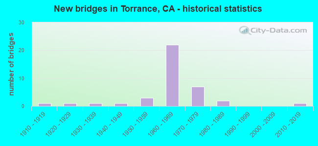
- New bridges - historical statistics
- 11910-1919
- 11920-1929
- 11930-1939
- 11940-1949
- 31950-1959
- 221960-1969
- 71970-1979
- 21980-1989
- 12010-2019

- Reconstructed bridges - Historical Statistics
- 11980-1989
- 01990-1999
- 02000-2009
- 12010-2019


- Bridge Condition - Deck
- 64.3%Good
- 7.1%Satisfactory
- 28.6%Fair

- Bridge Condition - Superstructure
- 87.5%Good
- 6.3%Satisfactory
- 6.3%Fair

- Bridge Condition - Substructure
- 93.8%Good
- 6.3%Fair

- Bridge Condition - Channel
- 91.7%Excellent
- 8.3%Good

- Bridge Condition - Culverts
- 11.1%Very good
- 66.7%Good
- 11.1%Satisfactory
- 11.1%Fair
Find on map >> Show street view
Structure Number: 53 1174, Location: 07-LA-405-14.92-TOR (Lat: 33.862103, Lng: -118.317603), Route carried "on" structure: Interstate 405, Year Built: 1962, Status: Open, Structure Length: 4.33m (14.21ft), Average Daily Traffic: 269,000 (year 2019), Truck Traffic: 5%, Average Future Daily Traffic: 304,690 (year 2038), Design Load: HS 20, Features Intersected: VAN NESS AVENUE
Minimum Vertical Clearance: 30+ m (98+ ft), Kilometerpoint: 14.920, Lanes on structure: 10, Lanes under structure: 4, Base Highway Network: Yes (Inventory Route: 4, Subroute: 1), Owner: State Highway Agency, Approaching Roadway Width: 42.0m (137.8ft), Skew: 32 degrees, Material/Design: Concrete continuous, Design/Construction: Box Beam or Girders - Multiple, Number Of Spans In Main Unit: 3, Length of Maximum Span: 26.8m (87.9ft), Curb-To-Curb Width: 41.5m (136.2ft), Out-to-Out Width: 42.9m (140.7ft)
Condition: Deck: Good, Superstructure: Good, Substructure: Good, Operating Rating: 54.1 metric tons, Method Used To Determine Operating Rating: Assigned rating based on Load Factor Design (LFD) reported in metric tons, Inventory Rating: 32.4 metric tons, Method Used To Determine Inventory Rating: Assigned rating based on Load Factor Design (LFD) reported in metric tons, Structural Evaluation: Better than present minimum criteria, Deck Geometry: Somewhat better than minimum adequacy, Underclear: Equal to present minimum criteria, Approach Roadway Alignment: Superior to present desirable criteria, Designated Inspection Frequency: Every 24 months, Inspection Date: November 2020, Deck Structure Type: Concrete Cast-file-Place
Find on map >> Show street view
Structure Number: 53 1175, Location: 07-LA-405-15.45-TOR (Lat: 33.864700, Lng: -118.326208), Route carried "on" structure: Interstate 405, Year Built: 1962, Status: Open, Structure Length: 5.50m (18.04ft), Average Daily Traffic: 269,000 (year 2019), Truck Traffic: 5%, Average Future Daily Traffic: 304,690 (year 2038), Design Load: HS 20, Features Intersected: CRENSHAW BLVD
Minimum Vertical Clearance: 30+ m (98+ ft), Kilometerpoint: 15.450, Lanes on structure: 12, Lanes under structure: 6, Base Highway Network: Yes (Inventory Route: 4, Subroute: 1), Owner: State Highway Agency, Approaching Roadway Width: 22.3m (73.2ft), Skew: 32 degrees, Material/Design: Concrete continuous, Design/Construction: Box Beam or Girders - Multiple, Number Of Spans In Main Unit: 3, Length of Maximum Span: 32.9m (107.9ft), Curb-To-Curb Width: 38.6m (126.6ft), Out-to-Out Width: 45.4m (149.0ft)
Condition: Deck: Good, Superstructure: Good, Substructure: Good, Operating Rating: 53.1 metric tons, Method Used To Determine Operating Rating: Load and Resistance Factor Rating (LRFR) rating reported by rating factor(RF) method using HL-93 loadings, Inventory Rating: 38.2 metric tons, Method Used To Determine Inventory Rating: Load and Resistance Factor Rating (LRFR) rating reported by rating factor(RF) method using HL-93 loadings, Structural Evaluation: Better than present minimum criteria, Deck Geometry: High priority of replacement, Underclear: Somewhat better than minimum adequacy, Approach Roadway Alignment: Superior to present desirable criteria, Designated Inspection Frequency: Every 24 months, Inspection Date: November 2020, Deck Structure Type: Concrete Cast-file-Place
Find on map >> Show street view
Structure Number: 53 1176, Location: 07-LA-405-15.73-TOR (Lat: 33.865997, Lng: -118.330558), Route carried "on" structure: Interstate 405, Year Built: 1962, Status: Open, Structure Length: 5.18m (16.99ft), Average Daily Traffic: 269,000 (year 2019), Truck Traffic: 5%, Average Future Daily Traffic: 304,690 (year 2038), Design Load: HS 20, Features Intersected: 182ND STREET
Minimum Vertical Clearance: 30+ m (98+ ft), Kilometerpoint: 15.730, Lanes on structure: 10, Lanes under structure: 4, Base Highway Network: Yes (Inventory Route: 4, Subroute: 1), Owner: State Highway Agency, Approaching Roadway Width: 42.0m (137.8ft), Skew: 33 degrees, Material/Design: Concrete continuous, Design/Construction: Box Beam or Girders - Multiple, Number Of Spans In Main Unit: 3, Length of Maximum Span: 30.8m (101.0ft), Curb-To-Curb Width: 41.4m (135.8ft), Out-to-Out Width: 42.6m (139.8ft)
Condition: Deck: Good, Superstructure: Good, Substructure: Good, Operating Rating: 54.1 metric tons, Method Used To Determine Operating Rating: Assigned rating based on Load Factor Design (LFD) reported in metric tons, Inventory Rating: 32.4 metric tons, Method Used To Determine Inventory Rating: Assigned rating based on Load Factor Design (LFD) reported in metric tons, Structural Evaluation: Better than present minimum criteria, Deck Geometry: Somewhat better than minimum adequacy, Underclear: Meets minimum limits, Approach Roadway Alignment: Superior to present desirable criteria, Length Of Structure Improvement: 5.18m (16.99ft), Designated Inspection Frequency: Every 24 months, Inspection Date: November 2020, Deck Structure Type: Concrete Cast-file-Place
Find on map >> Show street view
Structure Number: 53 1177, Location: 07-LA-405-15.98-TOR (Lat: 33.867303, Lng: -118.334781), Route carried "on" structure: Interstate 405, Year Built: 1962, Year Reconstructed: 1992, Status: Open, Structure Length: 1.98m (6.50ft), Average Daily Traffic: 269,000 (year 2019), Truck Traffic: 5%, Average Future Daily Traffic: 304,690 (year 2038), Design Load: HS 20, Features Intersected: YUKON AVENUE
Minimum Vertical Clearance: 30+ m (98+ ft), Kilometerpoint: 15.980, Lanes on structure: 10, Lanes under structure: 2, Base Highway Network: Yes (Inventory Route: 4, Subroute: 1), Owner: State Highway Agency, Approaching Roadway Width: 45.7m (149.9ft), Skew: 31 degrees, Material/Design: Concrete, Design/Construction: Box Beam or Girders - Multiple, Number Of Spans In Main Unit: 1, Number Of Approach Spans: 2, Length of Maximum Span: 19.8m (65.0ft), Curb-To-Curb Width: 45.7m (149.9ft), Out-to-Out Width: 47.4m (155.5ft)
Condition: Deck: Good, Superstructure: Good, Substructure: Good, Operating Rating: 54.1 metric tons, Method Used To Determine Operating Rating: Assigned rating based on Load Factor Design (LFD) reported in metric tons, Inventory Rating: 32.4 metric tons, Method Used To Determine Inventory Rating: Assigned rating based on Load Factor Design (LFD) reported in metric tons, Structural Evaluation: Better than present minimum criteria, Deck Geometry: Superior to present desirable criteria, Underclear: High priority of corrective action, Approach Roadway Alignment: Superior to present desirable criteria, Designated Inspection Frequency: Every 24 months, Inspection Date: November 2020, Deck Structure Type: Concrete Cast-file-Place
Find on map >> Show street view
Structure Number: 53 122, Location: 07-LA-005-39.92-LA (Lat: 34.273169, Lng: -118.449194), Route carried "on" structure: Interstate 5, Year Built: 1963, Year Reconstructed: 2010, Status: Open, Structure Length: 5.06m (16.60ft), Average Daily Traffic: 156,373 (year 2011), Truck Traffic: 10%, Average Future Daily Traffic: 210,335 (year 2043), Design Load: HS 20, Features Intersected: CHATSWORTH DR
Minimum Vertical Clearance: 30+ m (98+ ft), Kilometerpoint: 39.920, Lanes on structure: 11, Lanes under structure: 4, Base Highway Network: Yes (, Subroute: 1), Owner: State Highway Agency, Approaching Roadway Width: 48.7m (159.8ft), Skew: 31 degrees, Material/Design: Concrete continuous, Design/Construction: Box Beam or Girders - Multiple, Number Of Spans In Main Unit: 3, Length of Maximum Span: 26.5m (86.9ft), Curb-To-Curb Width: 48.7m (159.8ft), Out-to-Out Width: 50.4m (165.4ft)
Condition: Deck: Good, Superstructure: Good, Substructure: Good, Operating Rating: 92.0 metric tons, Method Used To Determine Operating Rating: Load Factor (LF), Inventory Rating: 55.4 metric tons, Method Used To Determine Inventory Rating: Load Factor (LF), Structural Evaluation: Better than present minimum criteria, Deck Geometry: Superior to present desirable criteria, Underclear: Superior to present desirable criteria, Approach Roadway Alignment: Equal to present desirable criteria, Designated Inspection Frequency: Every 24 months, Inspection Date: January 2021, Deck Structure Type: Concrete Cast-file-Place
Find on map >> Show street view
Structure Number: 53 1227, Location: 07-LA-405-16.56-TOR (Lat: 33.872619, Lng: -118.341778), Route carried "on" structure: Interstate 405, Year Built: 1962, Status: Open, Structure Length: 5.73m (18.80ft), Average Daily Traffic: 269,000 (year 2012), Truck Traffic: 5%, Average Future Daily Traffic: 304,690 (year 2037), Design Load: HS 20, Features Intersected: ARTESIA BLVD
Minimum Vertical Clearance: 30+ m (98+ ft), Kilometerpoint: 16.560, Lanes on structure: 12, Lanes under structure: 5, Base Highway Network: Yes (Inventory Route: 4, Subroute: 1), Owner: State Highway Agency, Approaching Roadway Width: 49.7m (163.1ft), Skew: 33 degrees, Material/Design: Concrete continuous, Design/Construction: Box Beam or Girders - Multiple, Number Of Spans In Main Unit: 4, Length of Maximum Span: 18.3m (60.0ft), Curb-To-Curb Width: 49.7m (163.1ft), Out-to-Out Width: 51.1m (167.7ft)
Condition: Deck: Good, Superstructure: Good, Substructure: Good, Operating Rating: 54.1 metric tons, Method Used To Determine Operating Rating: Assigned rating based on Load Factor Design (LFD) reported in metric tons, Inventory Rating: 32.4 metric tons, Method Used To Determine Inventory Rating: Assigned rating based on Load Factor Design (LFD) reported in metric tons, Structural Evaluation: Better than present minimum criteria, Deck Geometry: Equal to present minimum criteria, Underclear: Somewhat better than minimum adequacy, Approach Roadway Alignment: Superior to present desirable criteria, Designated Inspection Frequency: Every 24 months, Inspection Date: November 2020, Deck Structure Type: Concrete Cast-file-Place
Find on map >> Show street view
Structure Number: 53 1228, Location: 07-LA-405-16.78-TOR (Lat: 33.875675, Lng: -118.343956), Route carried "on" structure: Interstate 405, Year Built: 1962, Status: Open, Structure Length: 7.10m (23.29ft), Average Daily Traffic: 264,000 (year 2012), Truck Traffic: 5%, Average Future Daily Traffic: 304,690 (year 2037), Design Load: HS 20, Features Intersected: PRAIRIE AVENUE
Minimum Vertical Clearance: 30+ m (98+ ft), Kilometerpoint: 16.780, Lanes on structure: 10, Lanes under structure: 5, Base Highway Network: Yes (Inventory Route: 4, Subroute: 1), Owner: State Highway Agency, Approaching Roadway Width: 21.0m (68.9ft), Skew: 39 degrees, Material/Design: Concrete continuous, Design/Construction: Box Beam or Girders - Multiple, Number Of Spans In Main Unit: 4, Length of Maximum Span: 21.0m (68.9ft), Curb-To-Curb Width: 41.5m (136.2ft), Out-to-Out Width: 42.9m (140.7ft)
Condition: Deck: Good, Superstructure: Good, Substructure: Good, Operating Rating: 54.1 metric tons, Method Used To Determine Operating Rating: Assigned rating based on Load Factor Design (LFD) reported in metric tons, Inventory Rating: 32.4 metric tons, Method Used To Determine Inventory Rating: Assigned rating based on Load Factor Design (LFD) reported in metric tons, Structural Evaluation: Better than present minimum criteria, Deck Geometry: Somewhat better than minimum adequacy, Underclear: Somewhat better than minimum adequacy, Approach Roadway Alignment: Superior to present desirable criteria, Designated Inspection Frequency: Every 24 months, Inspection Date: November 2020, Deck Structure Type: Concrete Cast-file-Place
Find on map >> Show street view
Structure Number: 53 1229, Location: 07-LA-405-16.88-TOR (Lat: 33.876783, Lng: -118.344758), Route carried "on" structure: Interstate 405, Year Built: 1962, Status: Open, Structure Length: 4.94m (16.21ft), Average Daily Traffic: 264,000 (year 2019), Truck Traffic: 5%, Average Future Daily Traffic: 304,690 (year 2038), Design Load: HS 20, Features Intersected: REDONDO BEACH BLVD
Minimum Vertical Clearance: 30+ m (98+ ft), Kilometerpoint: 16.880, Lanes on structure: 10, Lanes under structure: 5, Base Highway Network: Yes (Inventory Route: 4, Subroute: 1), Owner: State Highway Agency, Approaching Roadway Width: 41.5m (136.2ft), Skew: 31 degrees, Material/Design: Concrete continuous, Design/Construction: Box Beam or Girders - Multiple, Number Of Spans In Main Unit: 3, Length of Maximum Span: 31.1m (102.0ft), Curb-To-Curb Width: 41.5m (136.2ft), Out-to-Out Width: 42.9m (140.7ft)
Condition: Deck: Fair, Superstructure: Good, Substructure: Good, Operating Rating: 38.6 metric tons, Method Used To Determine Operating Rating: Load and Resistance Factor Rating (LRFR) rating reported by rating factor(RF) method using HL-93 loadings, Inventory Rating: 27.9 metric tons, Method Used To Determine Inventory Rating: Load and Resistance Factor Rating (LRFR) rating reported by rating factor(RF) method using HL-93 loadings, Structural Evaluation: Better than present minimum criteria, Deck Geometry: Somewhat better than minimum adequacy, Underclear: Somewhat better than minimum adequacy, Approach Roadway Alignment: Superior to present desirable criteria, Designated Inspection Frequency: Every 24 months, Inspection Date: November 2020, Deck Structure Type: Concrete Cast-file-Place
Find on map >> Show street view
Structure Number: 53C0565, Location: 0.1MI W/O CRENSHAW BLVD (Lat: 33.882061, Lng: -118.328492), Route carried "on" structure: Other road , Year Built: 1978, Status: Open, Structure Length: 3.11m (10.20ft), Average Daily Traffic: 500 (year 2013), Average Future Daily Traffic: 600 (year 2041), Design Load: HS 20, Features Intersected: REDONDO BEACH BLVD, Facility Carried by Structure: EL CAMINO COLEGE M
Minimum Vertical Clearance: 30.47m (99.97ft), Kilometerpoint: 0.000, Lanes on structure: 4, Lanes under structure: 4, Owner: County Highway Agency, Approaching Roadway Width: 16.9m (55.4ft), Skew: 30 degrees, Material/Design: Prestressed concrete, Design/Construction: Box Beam or Girders - Multiple, Number Of Spans In Main Unit: 1, Length of Maximum Span: 30.5m (100.1ft), Curb or Sidewalk Widths: Left: 0.0m, Right: 9.1m (29.9ft), Curb-To-Curb Width: 20.5m (67.3ft), Out-to-Out Width: 32.6m (107.0ft)
Condition: Deck: Fair, Superstructure: Satisfactory, Substructure: Fair, Operating Rating: 74.5 metric tons, Method Used To Determine Operating Rating: Load Factor (LF), Inventory Rating: 44.7 metric tons, Method Used To Determine Inventory Rating: Load Factor (LF), Structural Evaluation: Somewhat better than minimum adequacy, Deck Geometry: Superior to present desirable criteria, Underclear: Equal to present minimum criteria, Approach Roadway Alignment: Equal to present minimum criteria, Designated Inspection Frequency: Every 24 months, Inspection Date: September 2021, Deck Structure Type: Concrete Cast-file-Place
Find on map >> Show street view
Structure Number: 53C0714, Location: 0.1 MI S/O ARTESIA BLVD (Lat: 33.871122, Lng: -118.309053), Route carried "on" structure: City street L005, Year Built: 1960, Status: Open, Structure Length: 2.38m (7.81ft), Average Daily Traffic: 33,280 (year 2012), Truck Traffic: 4%, Average Future Daily Traffic: 39,936 (year 2041), Design Load: HS 20, Features Intersected: DOMINGUEZ CHAN, Facility Carried by Structure: WESTERN AVE
Minimum Vertical Clearance: 30.47m (99.97ft), Kilometerpoint: 0.000, Lanes on structure: 4, Owner: City or Municipal Highway Agency, Approaching Roadway Width: 20.5m (67.3ft), Material/Design: Concrete, Design/Construction: Culvert, Number Of Spans In Main Unit: 3, Length of Maximum Span: 7.9m (25.9ft), Curb or Sidewalk Widths: Left: 1.6m (5.2ft), Right: 1.7m (5.6ft), Curb-To-Curb Width: 20.5m (67.3ft), Out-to-Out Width: 24.6m (80.7ft)
Condition: Channel: Excellent, Culverts: Fair, Operating Rating: 52.5 metric tons, Method Used To Determine Operating Rating: Load Factor (LF), Inventory Rating: 31.4 metric tons, Method Used To Determine Inventory Rating: Load Factor (LF), Structural Evaluation: Somewhat better than minimum adequacy, Deck Geometry: Superior to present desirable criteria, Waterway Adequacy: Superior to present desirable criteria, Approach Roadway Alignment: Equal to present desirable criteria, Designated Inspection Frequency: Every 24 months, Inspection Date: August 2021
Find on map >> Show street view
Structure Number: 53C0715, Location: 0.3MI S/O REDONDO BEACH (Lat: 33.879611, Lng: -118.326364), Route carried "on" structure: City street L036, Year Built: 1960, Status: Open, Structure Length: 2.37m (7.78ft), Average Daily Traffic: 32,240 (year 2012), Truck Traffic: 4%, Average Future Daily Traffic: 38,688 (year 2041), Features Intersected: DOMINGUEZ CHAN, Facility Carried by Structure: CRENSHAW BLVD
Minimum Vertical Clearance: 30+ m (98+ ft), Kilometerpoint: 0.000, Lanes on structure: 5, Owner: City or Municipal Highway Agency, Approaching Roadway Width: 23.5m (77.1ft), Skew: 1 degrees, Material/Design: Concrete, Design/Construction: Culvert, Number Of Spans In Main Unit: 3, Length of Maximum Span: 7.6m (24.9ft), Curb or Sidewalk Widths: Left: 1.6m (5.2ft), Right: 1.6m (5.2ft), Curb-To-Curb Width: 23.4m (76.8ft), Out-to-Out Width: 25.0m (82.0ft)
Condition: Channel: Excellent, Culverts: Good, Operating Rating: 40.5 metric tons, Method Used To Determine Operating Rating: Field evaluation and documented engineering judgment, Inventory Rating: 24.3 metric tons, Method Used To Determine Inventory Rating: Field evaluation and documented engineering judgment, Structural Evaluation: Equal to present minimum criteria, Deck Geometry: Better than present minimum criteria, Waterway Adequacy: Superior to present desirable criteria, Approach Roadway Alignment: Equal to present desirable criteria, Designated Inspection Frequency: Every 48 months, Inspection Date: August 2021
Find on map >> Show street view
Structure Number: 53C0852, Location: 0.5MI S/O 190TH ST (Lat: 33.852114, Lng: -118.344567), Route carried "on" structure: City street L665, Year Built: 1975, Status: Open, Structure Length: 11.22m (36.81ft), Average Daily Traffic: 52,000 (year 2012), Truck Traffic: 4%, Average Future Daily Traffic: 62,400 (year 2041), Design Load: HS 20, Features Intersected: BNSF, Facility Carried by Structure: PRAIRIE AVE
Minimum Vertical Clearance: 30.47m (99.97ft), Kilometerpoint: 0.000, Lanes on structure: 6, Owner: City or Municipal Highway Agency, Approaching Roadway Width: 21.3m (69.9ft), Skew: 21 degrees, Material/Design: Prestressed concrete, Design/Construction: Stringer/Multi-beam, Number Of Spans In Main Unit: 1, Number Of Approach Spans: 5, Length of Maximum Span: 29.3m (96.1ft), Curb or Sidewalk Widths: Left: 1.6m (5.2ft), Right: 3.0m (9.8ft), Curb-To-Curb Width: 21.3m (69.9ft), Out-to-Out Width: 30.9m (101.4ft)
Condition: Deck: Fair, Superstructure: Good, Substructure: Good, Operating Rating: 76.1 metric tons, Method Used To Determine Operating Rating: Load Factor (LF), Inventory Rating: 45.7 metric tons, Method Used To Determine Inventory Rating: Load Factor (LF), Structural Evaluation: Better than present minimum criteria, Deck Geometry: High priority of replacement, Underclear: Meets minimum limits, Approach Roadway Alignment: Equal to present minimum criteria, Designated Inspection Frequency: Every 24 months, Inspection Date: August 2021, Deck Structure Type: Concrete Cast-file-Place
Find on map >> Show street view
Structure Number: 53C146, Location: 0.4MI E/O ROSEMONT AVE (Lat: 34.216456, Lng: -118.233483), Route carried "on" structure: County highway , Year Built: 1936, Status: Open, Structure Length: 0.76m (2.49ft), Average Daily Traffic: 580 (year 2012), Truck Traffic: 1%, Average Future Daily Traffic: 638 (year 2041), Design Load: H 20, Features Intersected: PICKENS CYN CHAN, Facility Carried by Structure: EVELYN ST
Minimum Vertical Clearance: 30+ m (98+ ft), Kilometerpoint: 0.000, Lanes on structure: 2, Owner: County Highway Agency, Approaching Roadway Width: 7.0m (23.0ft), Material/Design: Concrete, Design/Construction: Slab, Number Of Spans In Main Unit: 1, Length of Maximum Span: 7.0m (23.0ft), Curb-To-Curb Width: 7.0m (23.0ft), Out-to-Out Width: 11.5m (37.7ft)
Condition: Deck: Good, Superstructure: Good, Substructure: Good, Channel: Excellent, Operating Rating: 59.0 metric tons, Method Used To Determine Operating Rating: Load Factor (LF), Inventory Rating: 35.3 metric tons, Method Used To Determine Inventory Rating: Load Factor (LF), Structural Evaluation: Better than present minimum criteria, Deck Geometry: Meets minimum limits, Waterway Adequacy: Superior to present desirable criteria, Approach Roadway Alignment: Equal to present desirable criteria, Designated Inspection Frequency: Every 48 months, Inspection Date: August 2021, Deck Structure Type: Concrete Cast-file-Place, Wearing Surface/Protective System: Wearing Surface: Bituminous
Find on map >> Show street view
Structure Number: 53C1469, Location: 0.3MI N/O ARTESIA BLVD (Lat: 33.876789, Lng: -118.313436), Route carried "on" structure: City street , Year Built: 1959, Status: Open, Structure Length: 2.79m (9.15ft), Average Daily Traffic: 4,646 (year 2012), Truck Traffic: 1%, Average Future Daily Traffic: 5,111 (year 2041), Features Intersected: DOMINGUEZ CHAN, Facility Carried by Structure: GRAMERCY PL
Minimum Vertical Clearance: 30+ m (98+ ft), Kilometerpoint: 0.000, Lanes on structure: 2, Owner: City or Municipal Highway Agency, Approaching Roadway Width: 10.7m (35.1ft), Skew: 3 degrees, Material/Design: Concrete, Design/Construction: Culvert, Number Of Spans In Main Unit: 3, Length of Maximum Span: 9.1m (29.9ft), Curb or Sidewalk Widths: Left: 1.6m (5.2ft), Right: 1.6m (5.2ft), Curb-To-Curb Width: 9.3m (30.5ft), Out-to-Out Width: 13.1m (43.0ft)
Condition: Channel: Excellent, Culverts: Satisfactory, Operating Rating: 40.5 metric tons, Method Used To Determine Operating Rating: Field evaluation and documented engineering judgment, Inventory Rating: 24.3 metric tons, Method Used To Determine Inventory Rating: Field evaluation and documented engineering judgment, Structural Evaluation: Equal to present minimum criteria, Deck Geometry: Meets minimum limits, Waterway Adequacy: Superior to present desirable criteria, Approach Roadway Alignment: Equal to present desirable criteria, Designated Inspection Frequency: Every 48 months, Inspection Date: August 2021
Find on map >> Show street view
Structure Number: 53C1561, Location: 200FT W/O CRENSHAW BLVD (Lat: 33.879753, Lng: -118.326936), Route carried "on" structure: City street , Year Built: 1960, Status: Open, Structure Length: 2.62m (8.60ft), Average Daily Traffic: 4,141 (year 2012), Truck Traffic: 2%, Average Future Daily Traffic: 4,555 (year 2041), Features Intersected: DOMINGUEZ CHAN, Facility Carried by Structure: CHERRY AVE
Minimum Vertical Clearance: 30+ m (98+ ft), Kilometerpoint: 0.000, Lanes on structure: 2, Owner: City or Municipal Highway Agency, Approaching Roadway Width: 10.4m (34.1ft), Skew: 2 degrees, Material/Design: Concrete, Design/Construction: Culvert, Number Of Spans In Main Unit: 3, Length of Maximum Span: 7.6m (24.9ft), Curb or Sidewalk Widths: Left: 1.6m (5.2ft), Right: 1.6m (5.2ft), Curb-To-Curb Width: 10.5m (34.4ft), Out-to-Out Width: 13.1m (43.0ft)
Condition: Channel: Excellent, Culverts: Good, Operating Rating: 40.5 metric tons, Method Used To Determine Operating Rating: Field evaluation and documented engineering judgment, Inventory Rating: 24.3 metric tons, Method Used To Determine Inventory Rating: Field evaluation and documented engineering judgment, Structural Evaluation: Equal to present minimum criteria, Deck Geometry: Somewhat better than minimum adequacy, Waterway Adequacy: Superior to present desirable criteria, Approach Roadway Alignment: Equal to present desirable criteria, Designated Inspection Frequency: Every 48 months, Inspection Date: August 2021
Find on map >> Show street view
Structure Number: 53C1562, Location: 0.3MI N/O ARTESIA BLVD (Lat: 33.877847, Lng: -118.317717), Route carried "on" structure: City street L134, Year Built: 1960, Status: Open, Structure Length: 2.32m (7.61ft), Average Daily Traffic: 14,280 (year 2012), Truck Traffic: 4%, Average Future Daily Traffic: 16,422 (year 2041), Features Intersected: DOMINGUEZ CHAN, Facility Carried by Structure: VAN NESS AVE
Minimum Vertical Clearance: 30+ m (98+ ft), Kilometerpoint: 0.000, Lanes on structure: 4, Owner: City or Municipal Highway Agency, Approaching Roadway Width: 17.0m (55.8ft), Skew: 1 degrees, Material/Design: Concrete, Design/Construction: Culvert, Number Of Spans In Main Unit: 3, Length of Maximum Span: 7.6m (24.9ft), Curb or Sidewalk Widths: Left: 1.6m (5.2ft), Right: 1.6m (5.2ft), Curb-To-Curb Width: 17.1m (56.1ft), Out-to-Out Width: 21.0m (68.9ft)
Condition: Channel: Excellent, Culverts: Good, Operating Rating: 40.5 metric tons, Method Used To Determine Operating Rating: Field evaluation and documented engineering judgment, Inventory Rating: 24.3 metric tons, Method Used To Determine Inventory Rating: Field evaluation and documented engineering judgment, Structural Evaluation: Equal to present minimum criteria, Deck Geometry: Somewhat better than minimum adequacy, Waterway Adequacy: Superior to present desirable criteria, Approach Roadway Alignment: Equal to present desirable criteria, Designated Inspection Frequency: Every 48 months, Inspection Date: August 2021
Find on map >> Show street view
Structure Number: 53C1652, Location: 100FT W/O WESTERN AVE (Lat: 33.838144, Lng: -118.309819), Route carried "on" structure: City street L071, Year Built: 1965, Status: Open, Structure Length: 0.82m (2.69ft), Average Daily Traffic: 31,200 (year 2012), Truck Traffic: 4%, Average Future Daily Traffic: 37,440 (year 2041), Design Load: HS 20, Features Intersected: STORM DRN #587, Facility Carried by Structure: TORRANCE BLVD
Minimum Vertical Clearance: 30+ m (98+ ft), Kilometerpoint: 0.000, Lanes on structure: 7, Owner: City or Municipal Highway Agency, Approaching Roadway Width: 17.9m (58.7ft), Skew: 20 degrees, Material/Design: Concrete, Design/Construction: Culvert, Number Of Spans In Main Unit: 2, Length of Maximum Span: 4.1m (13.5ft), Curb or Sidewalk Widths: Left: 7.4m (24.3ft), Right: 2.5m (8.2ft), Curb-To-Curb Width: 25.0m (82.0ft), Out-to-Out Width: 156.0m (511.8ft)
Condition: Channel: Excellent, Culverts: Good, Operating Rating: 54.1 metric tons, Method Used To Determine Operating Rating: Field evaluation and documented engineering judgment, Inventory Rating: 32.4 metric tons, Method Used To Determine Inventory Rating: Field evaluation and documented engineering judgment, Structural Evaluation: Better than present minimum criteria, Deck Geometry: High priority of replacement, Waterway Adequacy: Equal to present desirable criteria, Approach Roadway Alignment: Equal to present desirable criteria, Designated Inspection Frequency: Every 48 months, Inspection Date: August 2021
Find on map >> Show street view
Structure Number: 53C1653, Location: 0.5MI W/O WESTERN AVE (Lat: 33.849589, Lng: -118.317647), Route carried "on" structure: City street L134, Year Built: 1965, Status: Open, Structure Length: 0.98m (3.22ft), Average Daily Traffic: 18,720 (year 2012), Truck Traffic: 2%, Average Future Daily Traffic: 22,464 (year 2041), Design Load: HS 20, Features Intersected: STORM DRN #587, Facility Carried by Structure: VAN NESS AVE
Minimum Vertical Clearance: 30+ m (98+ ft), Kilometerpoint: 0.000, Lanes on structure: 4, Owner: City or Municipal Highway Agency, Approaching Roadway Width: 19.2m (63.0ft), Skew: 6 degrees, Material/Design: Concrete, Design/Construction: Culvert, Number Of Spans In Main Unit: 2, Length of Maximum Span: 3.0m (9.8ft), Curb or Sidewalk Widths: Left: 0.2m (0.7ft), Right: 2.5m (8.2ft), Curb-To-Curb Width: 19.2m (63.0ft), Out-to-Out Width: 21.8m (71.5ft)
Condition: Channel: Excellent, Culverts: Good, Operating Rating: 54.1 metric tons, Method Used To Determine Operating Rating: Field evaluation and documented engineering judgment, Inventory Rating: 32.4 metric tons, Method Used To Determine Inventory Rating: Field evaluation and documented engineering judgment, Structural Evaluation: Better than present minimum criteria, Deck Geometry: Equal to present minimum criteria, Waterway Adequacy: Superior to present desirable criteria, Approach Roadway Alignment: Equal to present desirable criteria, Designated Inspection Frequency: Every 48 months, Inspection Date: August 2021
Find on map >> Show street view
Structure Number: 53C1654, Location: 0.5MI N/O TORRANCE BLVD (Lat: 33.843686, Lng: -118.314319), Route carried "on" structure: City street , Year Built: 1980, Status: Open, Structure Length: 1.83m (6.00ft), Average Daily Traffic: 3,333 (year 2012), Truck Traffic: 4%, Average Future Daily Traffic: 3,666 (year 2041), Features Intersected: STORM DRN #587, Facility Carried by Structure: HARPERS WAY
Minimum Vertical Clearance: 30+ m (98+ ft), Kilometerpoint: 0.000, Lanes on structure: 2, Owner: City or Municipal Highway Agency, Approaching Roadway Width: 15.3m (50.2ft), Material/Design: Prestressed concrete, Design/Construction: Tee Beam, Number Of Spans In Main Unit: 1, Length of Maximum Span: 17.4m (57.1ft), Curb or Sidewalk Widths: Left: 1.6m (5.2ft), Right: 1.6m (5.2ft), Curb-To-Curb Width: 15.2m (49.9ft), Out-to-Out Width: 18.9m (62.0ft)
Condition: Deck: Satisfactory, Superstructure: Good, Substructure: Good, Channel: Excellent, Operating Rating: 54.1 metric tons, Method Used To Determine Operating Rating: Field evaluation and documented engineering judgment, Inventory Rating: 32.4 metric tons, Method Used To Determine Inventory Rating: Field evaluation and documented engineering judgment, Structural Evaluation: Better than present minimum criteria, Deck Geometry: Superior to present desirable criteria, Waterway Adequacy: Superior to present desirable criteria, Approach Roadway Alignment: Equal to present desirable criteria, Designated Inspection Frequency: Every 48 months, Inspection Date: August 2021, Deck Structure Type: Concrete Cast-file-Place, Wearing Surface/Protective System: Wearing Surface: Monolithic Concrete
Find on map >> Show street view
Structure Number: 53C1655, Location: 0.3MI S/O 190TH ST (Lat: 33.854644, Lng: -118.343514), Route carried "on" structure: City street L665, Year Built: 1975, Status: Open, Structure Length: 0.70m (2.30ft), Average Daily Traffic: 52,000 (year 2012), Truck Traffic: 4%, Average Future Daily Traffic: 62,400 (year 2041), Features Intersected: MOBIL OIL CO PIPELINES, Facility Carried by Structure: PRAIRIE AVE
Minimum Vertical Clearance: 30.47m (99.97ft), Kilometerpoint: 0.000, Lanes on structure: 6, Owner: City or Municipal Highway Agency, Approaching Roadway Width: 21.2m (69.6ft), Skew: 20 degrees, Material/Design: Steel, Design/Construction: Arch - Deck, Number Of Spans In Main Unit: 1, Length of Maximum Span: 7.0m (23.0ft), Curb or Sidewalk Widths: Left: 2.5m (8.2ft), Right: 3.7m (12.1ft), Curb-To-Curb Width: 21.2m (69.6ft), Out-to-Out Width: 32.1m (105.3ft)
Condition: Superstructure: Good, Substructure: Good, Operating Rating: 54.1 metric tons, Method Used To Determine Operating Rating: Field evaluation and documented engineering judgment, Inventory Rating: 32.4 metric tons, Method Used To Determine Inventory Rating: Field evaluation and documented engineering judgment, Structural Evaluation: Better than present minimum criteria, Deck Geometry: High priority of replacement, Approach Roadway Alignment: Equal to present minimum criteria, Designated Inspection Frequency: Every 24 months, Inspection Date: August 2021
Find on map >> Show street view
Structure Number: 53C1656, Location: 0.2MI S/O 190TH ST (Lat: 33.854558, Lng: -118.343522), Route carried "on" structure: City street L665, Year Built: 1975, Status: Open, Structure Length: 0.94m (3.08ft), Average Daily Traffic: 52,000 (year 2012), Truck Traffic: 4%, Average Future Daily Traffic: 62,400 (year 2041), Features Intersected: MOBIL OIL CO ACCESS RD, Facility Carried by Structure: PRAIRIE AVE
Minimum Vertical Clearance: 30.47m (99.97ft), Kilometerpoint: 0.000, Lanes on structure: 6, Lanes under structure: 1, Owner: City or Municipal Highway Agency, Approaching Roadway Width: 21.2m (69.6ft), Skew: 20 degrees, Material/Design: Steel, Design/Construction: Arch - Deck, Number Of Spans In Main Unit: 1, Length of Maximum Span: 9.4m (30.8ft), Curb or Sidewalk Widths: Left: 2.5m (8.2ft), Right: 3.7m (12.1ft), Curb-To-Curb Width: 21.2m (69.6ft), Out-to-Out Width: 32.1m (105.3ft)
Condition: Superstructure: Fair, Substructure: Good, Operating Rating: 26.9 metric tons, Method Used To Determine Operating Rating: Load Factor (LF), Inventory Rating: 16.2 metric tons, Method Used To Determine Inventory Rating: Load Factor (LF), Structural Evaluation: Meets minimum limits, Deck Geometry: High priority of replacement, Underclear: High priority of corrective action, Approach Roadway Alignment: Equal to present minimum criteria, Designated Inspection Frequency: Every 24 months, Inspection Date: August 2021
Find on map >> Show street view
Structure Number: 53C1702, Location: 0.4MI W/O STUDEBAKER RD (Lat: 33.872786, Lng: -118.102233), Route carried "on" structure: City street L090, Year Built: 1941, Status: Open, Structure Length: 0.70m (2.30ft), Average Daily Traffic: 31,091 (year 2018), Truck Traffic: 2%, Average Future Daily Traffic: 35,262 (year 2040), Features Intersected: DRN CHAN, Facility Carried by Structure: ARTESIA BLVD
Minimum Vertical Clearance: 30.47m (99.97ft), Kilometerpoint: 0.000, Lanes on structure: 4, Owner: City or Municipal Highway Agency, Approaching Roadway Width: 20.0m (65.6ft), Skew: 23 degrees, Material/Design: Concrete, Design/Construction: Culvert, Number Of Spans In Main Unit: 3, Length of Maximum Span: 1.8m (5.9ft), Curb or Sidewalk Widths: Left: 2.2m (7.2ft), Right: 2.2m (7.2ft), Curb-To-Curb Width: 21.2m (69.6ft), Out-to-Out Width: 38.0m (124.7ft)
Condition: Channel: Excellent, Culverts: Very good, Operating Rating: 40.5 metric tons, Method Used To Determine Operating Rating: Field evaluation and documented engineering judgment, Inventory Rating: 24.3 metric tons, Method Used To Determine Inventory Rating: Field evaluation and documented engineering judgment, Structural Evaluation: Equal to present minimum criteria, Deck Geometry: Superior to present desirable criteria, Waterway Adequacy: Superior to present desirable criteria, Approach Roadway Alignment: Superior to present desirable criteria, Designated Inspection Frequency: Every 24 months, Inspection Date: June 2020
Find on map >> Show street view
Structure Number: 53C2039, Location: 0.1MI W/O WESTERN AVE (Lat: 33.872733, Lng: -118.311572), Route carried "on" structure: City street L090, Year Built: 1958, Status: Open, Structure Length: 2.41m (7.91ft), Average Daily Traffic: 37,440 (year 2012), Truck Traffic: 6%, Average Future Daily Traffic: 46,758 (year 2043), Design Load: HS 20, Features Intersected: DOMINGUEZ CHAN, Facility Carried by Structure: ARTESIA BLVD
Minimum Vertical Clearance: 30+ m (98+ ft), Kilometerpoint: 0.000, Lanes on structure: 4, Owner: City or Municipal Highway Agency, Approaching Roadway Width: 24.0m (78.7ft), Skew: 21 degrees, Material/Design: Concrete continuous, Design/Construction: Tee Beam, Number Of Spans In Main Unit: 2, Length of Maximum Span: 11.9m (39.0ft), Curb or Sidewalk Widths: Left: 1.8m (5.9ft), Right: 1.8m (5.9ft), Curb-To-Curb Width: 23.7m (77.8ft), Out-to-Out Width: 31.7m (104.0ft)
Condition: Deck: Good, Superstructure: Good, Substructure: Good, Channel: Excellent, Operating Rating: 49.2 metric tons, Method Used To Determine Operating Rating: Load Factor (LF), Inventory Rating: 29.5 metric tons, Method Used To Determine Inventory Rating: Load Factor (LF), Structural Evaluation: Better than present minimum criteria, Deck Geometry: Superior to present desirable criteria, Waterway Adequacy: Equal to present desirable criteria, Approach Roadway Alignment: Equal to present desirable criteria, Designated Inspection Frequency: Every 48 months, Inspection Date: August 2021, Deck Structure Type: Concrete Cast-file-Place, Wearing Surface/Protective System: Wearing Surface: Epoxy Overlay
Find on map >> Show street view
Structure Number: 53C232, Location: 125FEET S/O SIERRA HWY (Lat: 34.365419, Lng: -118.505272), Route carried "on" structure: Alternate City street , Year Built: 1969, Status: Open, Structure Length: 17.10m (56.10ft), Average Daily Traffic: 37,000 (year 2012), Truck Traffic: 2%, Average Future Daily Traffic: 65,097 (year 2040), Features Intersected: ELSMERE CREEK, Facility Carried by Structure: NEWHALL AVE
Minimum Vertical Clearance: 30.47m (99.97ft), Kilometerpoint: 1.999, Lanes on structure: 7, Owner: City or Municipal Highway Agency, Approaching Roadway Width: 30.0m (98.4ft), Skew: 29 degrees, Material/Design: Concrete, Design/Construction: Culvert, Number Of Spans In Main Unit: 2, Length of Maximum Span: 3.0m (9.8ft), Curb-To-Curb Width: 30.0m (98.4ft), Out-to-Out Width: 30.0m (98.4ft)
Condition: Channel: Good, Culverts: Good, Operating Rating: 54.1 metric tons, Method Used To Determine Operating Rating: Field evaluation and documented engineering judgment, Inventory Rating: 32.4 metric tons, Method Used To Determine Inventory Rating: Field evaluation and documented engineering judgment, Structural Evaluation: Better than present minimum criteria, Deck Geometry: Equal to present minimum criteria, Waterway Adequacy: Equal to present desirable criteria, Approach Roadway Alignment: Equal to present desirable criteria, Designated Inspection Frequency: Every 48 months, Inspection Date: Febuary 2020
Find on map >> Show street view
Structure Number: 53C2328, Location: 0.4 ML E/O PRAIRIE AVE (Lat: 33.847333, Lng: -118.338111), Route carried "on" structure: City street , Year Built: 2013, Status: Open, Structure Length: 4.22m (13.85ft), Average Daily Traffic: 10,000 (year 2015), Truck Traffic: 1%, Average Future Daily Traffic: 12,000 (year 2041), Design Load: HS 20+Mod, Features Intersected: RAILROAD, Facility Carried by Structure: DEL AMO
Minimum Vertical Clearance: 30.47m (99.97ft), Kilometerpoint: 0.000, Lanes on structure: 4, Owner: City or Municipal Highway Agency, Approaching Roadway Width: 21.5m (70.5ft), Skew: 33 degrees, Material/Design: Prestressed concrete, Design/Construction: Stringer/Multi-beam, Number Of Spans In Main Unit: 1, Length of Maximum Span: 38.2m (125.3ft), Curb-To-Curb Width: 21.5m (70.5ft), Out-to-Out Width: 23.1m (75.8ft)
Condition: Deck: Fair, Superstructure: Good, Substructure: Good, Operating Rating: 85.5 metric tons, Method Used To Determine Operating Rating: Load Factor (LF), Inventory Rating: 41.8 metric tons, Method Used To Determine Inventory Rating: Load Factor (LF), Structural Evaluation: Better than present minimum criteria, Deck Geometry: Superior to present desirable criteria, Underclear: Equal to present minimum criteria, Approach Roadway Alignment: Better than present minimum criteria, Designated Inspection Frequency: Every 24 months, Inspection Date: March 2021, Deck Structure Type: Concrete Cast-file-Place
Find on map >> Show street view
Structure Number: 53 004, Location: 07-LA-001-16.81-TOR (Lat: 33.809878, Lng: -118.363758), Route carried "under" structure: State highway 1, Year Built: 1959, Structure Length: 0. m, Average Daily Traffic: 38,100 (year 2011), Truck Traffic: 4%, Features Intersected: STATE ROUTE 1, Facility Carried by Structure: PEDESTRIAN WALKWAY
Minimum Vertical Clearance: 4.57m (14.99ft), Kilometerpoint: 16.810, Lanes under structure: 4, Material/Design: Concrete continuous, Design/Construction: Slab, Length of Maximum Span: 30.8m (101.0ft)
Find on map >> Show street view
Structure Number: 53 0183, Location: 07-LA-107-3.73-TOR (Lat: 33.858944, Lng: -118.353361), Route carried "under" structure: State highway 107, Year Built: 1926, Structure Length: 0. m, Average Daily Traffic: 67,000 (year 2009), Truck Traffic: 3%, Features Intersected: SR 107 (HAWTHORNE), Facility Carried by Structure: BNSF RY
Minimum Vertical Clearance: 4.65m (15.26ft), Kilometerpoint: 3.730, Lanes under structure: 8, Material/Design: Steel, Design/Construction: Girder and Floorbeam System, Length of Maximum Span: 19.1m (62.7ft)
Find on map >> Show street view
Structure Number: 53 1174, Location: 07-LA-405-14.92-TOR (Lat: 33.862103, Lng: -118.317603), Route carried "under" structure: City street L134, Year Built: 1962, Structure Length: 0. m, Average Daily Traffic: 11,700 (year 2015), Truck Traffic: 1%, Features Intersected: VAN NESS AVENUE, Facility Carried by Structure: INTERSTATE 405
Minimum Vertical Clearance: 4.62m (15.16ft), Kilometerpoint: 0.000, Lanes on structure: 10, Lanes under structure: 4, Material/Design: Concrete continuous, Design/Construction: Box Beam or Girders - Multiple, Length of Maximum Span: 26.8m (87.9ft)
Find on map >> Show street view
Structure Number: 53 1175, Location: 07-LA-405-15.45-TOR (Lat: 33.864700, Lng: -118.326208), Route carried "under" structure: City street L036, Year Built: 1962, Structure Length: 0. m, Average Daily Traffic: 25,000 (year 2015), Truck Traffic: 2%, Features Intersected: CRENSHAW BLVD, Facility Carried by Structure: INTERSTATE 405
Minimum Vertical Clearance: 4.64m (15.22ft), Kilometerpoint: 0.000, Lanes on structure: 12, Lanes under structure: 6, Material/Design: Concrete continuous, Design/Construction: Box Beam or Girders - Multiple, Length of Maximum Span: 32.9m (107.9ft)
Find on map >> Show street view
Structure Number: 53 1176, Location: 07-LA-405-15.73-TOR (Lat: 33.865997, Lng: -118.330558), Route carried "under" structure: City street , Year Built: 1962, Structure Length: 0. m, Average Daily Traffic: 18,500 (year 2015), Truck Traffic: 1%, Features Intersected: 182ND STREET, Facility Carried by Structure: INTERSTATE 405
Minimum Vertical Clearance: 4.57m (14.99ft), Kilometerpoint: 0.000, Lanes on structure: 10, Lanes under structure: 4, Material/Design: Concrete continuous, Design/Construction: Box Beam or Girders - Multiple, Length of Maximum Span: 30.8m (101.0ft)
Find on map >> Show street view
Structure Number: 53 1177, Location: 07-LA-405-15.98-TOR (Lat: 33.867303, Lng: -118.334781), Route carried "under" structure: City street , Year Built: 1962, Structure Length: 0. m, Average Daily Traffic: 5,000 (year 2015), Truck Traffic: 2%, Features Intersected: YUKON AVENUE, Facility Carried by Structure: INTERSTATE 405
Minimum Vertical Clearance: 4.57m (14.99ft), Kilometerpoint: 0.000, Lanes on structure: 10, Lanes under structure: 2, Material/Design: Concrete, Design/Construction: Box Beam or Girders - Multiple, Length of Maximum Span: 19.8m (65.0ft)
Find on map >> Show street view
Structure Number: 53 1227, Location: 07-LA-405-16.56-TOR (Lat: 33.872619, Lng: -118.341778), Route carried "under" structure: City street , Year Built: 1962, Structure Length: 0. m, Average Daily Traffic: 40,000 (year 2015), Truck Traffic: 2%, Features Intersected: ARTESIA BLVD, Facility Carried by Structure: INTERSTATE 405
Minimum Vertical Clearance: 4.69m (15.39ft), Kilometerpoint: 0.000, Lanes on structure: 12, Lanes under structure: 5, Material/Design: Concrete continuous, Design/Construction: Box Beam or Girders - Multiple, Length of Maximum Span: 18.3m (60.0ft)
Find on map >> Show street view
Structure Number: 53 1228, Location: 07-LA-405-16.78-TOR (Lat: 33.875675, Lng: -118.343956), Route carried "under" structure: City street L665, Year Built: 1962, Structure Length: 0. m, Average Daily Traffic: 37,294 (year 2015), Truck Traffic: 2%, Features Intersected: PRAIRIE AVENUE, Facility Carried by Structure: INTERSTATE 405
Minimum Vertical Clearance: 6.98m (22.90ft), Kilometerpoint: 0.000, Lanes on structure: 10, Lanes under structure: 5, Material/Design: Concrete continuous, Design/Construction: Box Beam or Girders - Multiple, Length of Maximum Span: 21.0m (68.9ft)
Find on map >> Show street view
Structure Number: 53 1229, Location: 07-LA-405-16.88-TOR (Lat: 33.876783, Lng: -118.344758), Route carried "under" structure: City street L077, Year Built: 1962, Structure Length: 0. m, Average Daily Traffic: 36,103 (year 2015), Truck Traffic: 2%, Features Intersected: REDONDO BEACH BLVD, Facility Carried by Structure: INTERSTATE 405
Minimum Vertical Clearance: 4.95m (16.24ft), Kilometerpoint: 0.000, Lanes on structure: 10, Lanes under structure: 5, Material/Design: Concrete continuous, Design/Construction: Box Beam or Girders - Multiple, Length of Maximum Span: 31.1m (102.0ft)
Find on map >> Show street view
Structure Number: 53C0565, Location: 0.1MI W/O CRENSHAW BLVD (Lat: 33.882061, Lng: -118.328492), Route carried "under" structure: County highway , Year Built: 1978, Structure Length: 0. m, Average Daily Traffic: 26,624 (year 2013), Truck Traffic: 2%, Features Intersected: REDONDO BEACH BLVD, Facility Carried by Structure: EL CAMINO COLEGE M
Minimum Vertical Clearance: 4.71m (15.45ft), Kilometerpoint: 0.000, Lanes on structure: 4, Lanes under structure: 4, Material/Design: Prestressed concrete, Design/Construction: Box Beam or Girders - Multiple, Length of Maximum Span: 30.5m (100.1ft)
Find on map >> Show street view
Structure Number: 53C0566, Location: 200FT E/O HAWTHORNE BLVD (Lat: 33.858019, Lng: -118.352028), Route carried "under" structure: City street L074, Year Built: 1979, Structure Length: 0. m, Average Daily Traffic: 39,520 (year 2012), Truck Traffic: 4%, Features Intersected: 190 TH ST UP, Facility Carried by Structure: ATSF RR
Minimum Vertical Clearance: 4.57m (14.99ft), Kilometerpoint: 0.000, Lanes under structure: 5, Material/Design: Prestressed concrete, Design/Construction: Box Beam or Girders - Multiple, Length of Maximum Span: 22.9m (75.1ft)
Find on map >> Show street view
Structure Number: 53C1563, Location: 0.3MI N/O 190TH ST (Lat: 33.861719, Lng: -118.343950), Route carried "under" structure: City street L665, Year Built: 1976, Structure Length: 0. m, Average Daily Traffic: 39,520 (year 2012), Truck Traffic: 4%, Features Intersected: PRAIRIE AVE, Facility Carried by Structure: 186TH ST POC
Minimum Vertical Clearance: 5.02m (16.47ft), Kilometerpoint: 0.000, Lanes under structure: 5, Material/Design: Steel, Design/Construction: Truss - Thru, Length of Maximum Span: 24.4m (80.1ft)
Find on map >> Show street view
Structure Number: 53C1564, Location: 0.1MI W/O WESTERN AVE (Lat: 33.837394, Lng: -118.311572), Route carried "under" structure: City street L071, Year Built: 1913, Structure Length: 0. m, Average Daily Traffic: 31,200 (year 2012), Truck Traffic: 4%, Features Intersected: TORRANCE BLVD ; UPRR, Facility Carried by Structure: UPRR
Minimum Vertical Clearance: 4.00m (13.12ft), Kilometerpoint: 0.000, Lanes under structure: 4, Material/Design: Concrete, Design/Construction: Tee Beam, Length of Maximum Span: 10.4m (34.1ft)
Find on map >> Show street view
Structure Number: 53C1701, Location: 0.3MI N/O TORRANCE BLVD (Lat: 33.840308, Lng: -118.328497), Route carried "under" structure: City street L036, Year Built: 1980, Structure Length: 0. m, Average Daily Traffic: 49,920 (year 2012), Truck Traffic: 4%, Features Intersected: CRENSHAW BLVD UP, Facility Carried by Structure: ATSF RR
Minimum Vertical Clearance: 4.60m (15.09ft), Kilometerpoint: 0.000, Lanes under structure: 6, Material/Design: Prestressed concrete, Design/Construction: Box Beam or Girders - Multiple, Length of Maximum Span: 17.1m (56.1ft)