Bridge Statistics for Washington, Louisiana (LA)
Condition, Traffic, Stress, Structural Evaluation, Project Costs
- National Bridge Inventory (NBI) Statistics
- 40Number of bridges
- 896ft / 273mTotal length
- $4,304,000Total costs
- 303,007Total average daily traffic
- 46,256Total average daily truck traffic
- National Bridge Inventory (NBI) Registered Bridges for Washington
- No street view available for this location
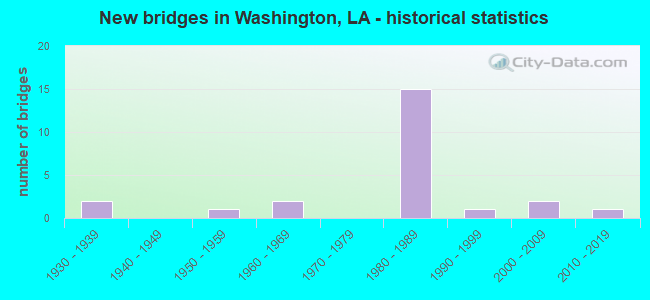
- New bridges - historical statistics
- 21930-1939
- 11950-1959
- 21960-1969
- 151980-1989
- 11990-1999
- 22000-2009
- 12010-2019


- Bridge Condition - Deck
- 9.5%Very good
- 61.9%Good
- 23.8%Satisfactory
- 4.8%Fair

- Bridge Condition - Superstructure
- 9.5%Very good
- 57.1%Good
- 23.8%Satisfactory
- 9.5%Fair

- Bridge Condition - Substructure
- 9.5%Very good
- 57.1%Good
- 19.0%Satisfactory
- 4.8%Fair
- 9.5%Poor

- Bridge Condition - Channel
- 36.8%Very good
- 47.4%Good
- 15.8%Satisfactory

- Bridge Condition - Culverts
- 66.7%Good
- 33.3%Satisfactory
Find on map >> Show street view
Structure Number: 34900000030378, Location: 1.0 MI E of LA 743 (Lat: 30.620689, Lng: -92.019600), Route carried "on" structure: State highway 103, Year Built: 2009, Status: Open, Structure Length: 7.32m (24.02ft), Average Daily Traffic: 2,500 (year 2016), Truck Traffic: 15%, Average Future Daily Traffic: 3,380 (year 2036), Design Load: HS 20, Features Intersected: BAYOU COURTBLEAU
Minimum Vertical Clearance: 30+ m (98+ ft), Kilometerpoint: 4.048, Lanes on structure: 2, Owner: State Highway Agency, Approaching Roadway Width: 11.6m (38.1ft), Skew: 30 degrees, Material/Design: Prestressed concrete, Design/Construction: Box Beam or Girders - Multiple, Number Of Spans In Main Unit: 6, Length of Maximum Span: 12.2m (40.0ft), Curb-To-Curb Width: 12.2m (40.0ft), Out-to-Out Width: 13.1m (43.0ft)
Condition: Deck: Very good, Superstructure: Very good, Substructure: Very good, Channel: Satisfactory, Operating Rating: 53.1 metric tons, Method Used To Determine Operating Rating: Load and Resistance Factor Rating (LRFR) rating reported by rating factor(RF) method using HL-93 loadings, Inventory Rating: 35.6 metric tons, Method Used To Determine Inventory Rating: Load and Resistance Factor Rating (LRFR) rating reported by rating factor(RF) method using HL-93 loadings, Structural Evaluation: Equal to present desirable criteria, Deck Geometry: Equal to present minimum criteria, Waterway Adequacy: Equal to present desirable criteria, Approach Roadway Alignment: Equal to present desirable criteria, Designated Inspection Frequency: Every 24 months, Underwater Inspection Frequency: Every 60 months, Inspection Date: Febuary 2020, Underwater Inspection Date: June 2020, Deck Structure Type: Concrete Cast-file-Place, Wearing Surface/Protective System: Wearing Surface: Monolithic Concrete
Find on map >> Show street view
Structure Number: 34900000800255, Location: 2.56 Mi NW of US 167 (Lat: 30.620681, Lng: -92.092219), Route carried "on" structure: County highway , Year Built: 2013, Status: Open, Structure Length: 1.83m (6.00ft), Average Daily Traffic: 325 (year 2020), Average Future Daily Traffic: 357 (year 2040), Design Load: HS 20, Features Intersected: BELLEVIEW BAYOU, Facility Carried by Structure: Prayer House Rd
Minimum Vertical Clearance: 30+ m (98+ ft), Kilometerpoint: 0.000, Lanes on structure: 2, Owner: County Highway Agency, Approaching Roadway Width: 5.8m (19.0ft), Skew: 30 degrees, Material/Design: Concrete, Design/Construction: Slab, Number Of Spans In Main Unit: 3, Length of Maximum Span: 6.1m (20.0ft), Curb-To-Curb Width: 7.3m (24.0ft), Out-to-Out Width: 8.0m (26.2ft)
Condition: Deck: Very good, Superstructure: Very good, Substructure: Very good, Channel: Good, Operating Rating: 51.5 metric tons, Method Used To Determine Operating Rating: Load and Resistance Factor Rating (LRFR) rating reported by rating factor(RF) method using HL-93 loadings, Inventory Rating: 39.9 metric tons, Method Used To Determine Inventory Rating: Load and Resistance Factor Rating (LRFR) rating reported by rating factor(RF) method using HL-93 loadings, Structural Evaluation: Equal to present desirable criteria, Deck Geometry: Somewhat better than minimum adequacy, Waterway Adequacy: Equal to present desirable criteria, Approach Roadway Alignment: Equal to present desirable criteria, Designated Inspection Frequency: Every 24 months, Inspection Date: January 2021, Deck Structure Type: Concrete Precast Panels, Wearing Surface/Protective System: Wearing Surface: Monolithic Concrete
Find on map >> Show street view
Structure Number: 34900320305681, Location: 1.6 MI NORTH OF LA 10 (Lat: 30.610161, Lng: -92.064100), Route carried "on" structure: State highway 10, Year Built: 1936, Status: Open, Structure Length: 5.55m (18.21ft), Average Daily Traffic: 2,900 (year 2016), Truck Traffic: 9%, Average Future Daily Traffic: 3,900 (year 2036), Design Load: H 15, Features Intersected: BAYOU CARRON
Minimum Vertical Clearance: 30+ m (98+ ft), Kilometerpoint: 9.204, Lanes on structure: 2, Owner: State Highway Agency, Approaching Roadway Width: 12.2m (40.0ft), Skew: 2 degrees, Material/Design: Concrete, Design/Construction: Tee Beam, Number Of Spans In Main Unit: 6, Length of Maximum Span: 9.1m (29.9ft), Curb-To-Curb Width: 9.1m (29.9ft), Out-to-Out Width: 10.8m (35.4ft)
Condition: Deck: Satisfactory, Superstructure: Satisfactory, Substructure: Fair, Channel: Good, Operating Rating: 37.9 metric tons, Method Used To Determine Operating Rating: Load and Resistance Factor Rating (LRFR) rating reported by rating factor(RF) method using HL-93 loadings, Inventory Rating: 29.5 metric tons, Method Used To Determine Inventory Rating: Load and Resistance Factor Rating (LRFR) rating reported by rating factor(RF) method using HL-93 loadings, Structural Evaluation: Somewhat better than minimum adequacy, Deck Geometry: Meets minimum limits, Waterway Adequacy: Better than present minimum criteria, Approach Roadway Alignment: Equal to present desirable criteria, Designated Inspection Frequency: Every 24 months, Inspection Date: August 2021, Deck Structure Type: Concrete Cast-file-Place
Find on map >> Show street view
Structure Number: 34900320400001, Location: 0.02 MI EAST OF LA 103 (Lat: 30.617331, Lng: -92.055850), Route carried "on" structure: State highway 10, Year Built: 1936, Status: Posted for load, Structure Length: 8.99m (29.49ft), Average Daily Traffic: 3,500 (year 2016), Truck Traffic: 13%, Average Future Daily Traffic: 4,550 (year 2036), Design Load: H 15, Features Intersected: BAYOU COURTABLEAU
Minimum Vertical Clearance: 30+ m (98+ ft), Kilometerpoint: 0.000, Lanes on structure: 2, Owner: State Highway Agency, Approaching Roadway Width: 12.2m (40.0ft), Material/Design: Steel, Design/Construction: Stringer/Multi-beam, Number Of Spans In Main Unit: 1, Number Of Approach Spans: 6, Length of Maximum Span: 13.7m (44.9ft), Curb or Sidewalk Widths: Left: 0.0m, Right: 0.7m (2.3ft), Curb-To-Curb Width: 7.3m (24.0ft), Out-to-Out Width: 10.0m (32.8ft)
Condition: Deck: Fair, Superstructure: Fair, Substructure: Satisfactory, Channel: Satisfactory, Operating Rating: 20.4 metric tons, Method Used To Determine Operating Rating: Load and Resistance Factor Rating (LRFR) rating reported by rating factor(RF) method using HL-93 loadings, Inventory Rating: 15.9 metric tons, Method Used To Determine Inventory Rating: Load and Resistance Factor Rating (LRFR) rating reported by rating factor(RF) method using HL-93 loadings, Structural Evaluation: Meets minimum limits, Deck Geometry: High priority of replacement, Waterway Adequacy: Equal to present desirable criteria, Approach Roadway Alignment: Equal to present desirable criteria, Bridge Posting: Required (Relationship of Operating Rating to Maximum Legal Load: 20.0 - 29.9% below), Length Of Structure Improvement: 9.91m (32.51ft), Designated Inspection Frequency: Every 24 months, Critical Feature Inspection Frequency: Every 24 months, Underwater Inspection Frequency: Every 60 months, Inspection Date: March 2021, Critical Feature Inspection Date: March 2021, Underwater Inspection Date: May 2018, Bridge Improvement Cost: $845,000, Total Project Cost: $1,267,000 ( Estimate for 2016), Deck Structure Type: Concrete Cast-file-Place
Find on map >> Show street view
Structure Number: 34900660808991, Location: 1.4 MI SOUTH OF LA 749 (Lat: 30.587489, Lng: -92.074300), Route carried "on" structure: US 167, Year Built: 1955, Status: Open, Structure Length: 0.73m (2.40ft), Average Daily Traffic: 6,900 (year 2016), Truck Traffic: 9%, Average Future Daily Traffic: 8,970 (year 2036), Design Load: H 15, Features Intersected: B BELLEVIEW
Minimum Vertical Clearance: 30+ m (98+ ft), Kilometerpoint: 14.396, Lanes on structure: 2, Owner: State Highway Agency, Approaching Roadway Width: 12.2m (40.0ft), Skew: 3 degrees, Material/Design: Concrete, Design/Construction: Culvert, Number Of Spans In Main Unit: 3, Length of Maximum Span: 2.1m (6.9ft), Curb-To-Curb Width: 12.0m (39.4ft), Out-to-Out Width: 13.7m (44.9ft)
Condition: Channel: Good, Culverts: Good, Operating Rating: 42.1 metric tons, Method Used To Determine Operating Rating: Load and Resistance Factor Rating (LRFR) rating reported by rating factor(RF) method using HL-93 loadings, Inventory Rating: 32.4 metric tons, Method Used To Determine Inventory Rating: Load and Resistance Factor Rating (LRFR) rating reported by rating factor(RF) method using HL-93 loadings, Structural Evaluation: Better than present minimum criteria, Deck Geometry: Somewhat better than minimum adequacy, Waterway Adequacy: Better than present minimum criteria, Approach Roadway Alignment: Equal to present desirable criteria, Designated Inspection Frequency: Every 24 months, Inspection Date: December 2020, Deck Structure Type: Concrete Cast-file-Place
Find on map >> Show street view
Structure Number: 34904550200001, Location: 1.0 MI NORTH OF LA 182 (Lat: 30.378881, Lng: -92.052969), Route carried "on" structure: Interstate 49, Year Built: 1963, Status: Open, Structure Length: 4.88m (16.01ft), Average Daily Traffic: 19,200 (year 2016), Truck Traffic: 28%, Average Future Daily Traffic: 29,406 (year 2036), Design Load: HS 20, Features Intersected: BAYOU CARENCRO
Minimum Vertical Clearance: 30+ m (98+ ft), Kilometerpoint: 0.003, Lanes on structure: 2, Base Highway Network: Yes (Inventory Route: 455-02-1, Subroute: 10), Owner: State Highway Agency, Approaching Roadway Width: 11.6m (38.1ft), Skew: 10 degrees, Material/Design: Concrete, Design/Construction: Slab, Number Of Spans In Main Unit: 8, Length of Maximum Span: 6.1m (20.0ft), Curb-To-Curb Width: 12.2m (40.0ft), Out-to-Out Width: 13.0m (42.7ft)
Condition: Deck: Satisfactory, Superstructure: Satisfactory, Substructure: Satisfactory, Channel: Very good, Operating Rating: 24.3 metric tons, Method Used To Determine Operating Rating: Load and Resistance Factor Rating (LRFR) rating reported by rating factor(RF) method using HL-93 loadings, Inventory Rating: 18.8 metric tons, Method Used To Determine Inventory Rating: Load and Resistance Factor Rating (LRFR) rating reported by rating factor(RF) method using HL-93 loadings, Structural Evaluation: Meets minimum limits, Deck Geometry: Better than present minimum criteria, Waterway Adequacy: Equal to present desirable criteria, Approach Roadway Alignment: Equal to present desirable criteria, Designated Inspection Frequency: Every 24 months, Inspection Date: May 2021, Deck Structure Type: Concrete Cast-file-Place
Find on map >> Show street view
Structure Number: 34904550214404, Location: 0.46 MI S of US 167 (Lat: 30.577981, Lng: -92.050900), Route carried "on" structure: ServiceInterstate 49, Year Built: 1983, Status: Open, Structure Length: 0.67m (2.20ft), Average Daily Traffic: 2,880 (year 2016), Truck Traffic: 13%, Average Future Daily Traffic: 3,666 (year 2036), Design Load: HS 20, Features Intersected: KENNISON BAYOU
Minimum Vertical Clearance: 30+ m (98+ ft), Kilometerpoint: 0.755, Lanes on structure: 2, Owner: State Highway Agency, Approaching Roadway Width: 13.4m (44.0ft), Skew: 7 degrees, Material/Design: Concrete, Design/Construction: Culvert, Number Of Spans In Main Unit: 2, Length of Maximum Span: 2.7m (8.9ft), Curb-To-Curb Width: 12.2m (40.0ft), Out-to-Out Width: 19.2m (63.0ft)
Condition: Channel: Good, Culverts: Good, Operating Rating: 42.1 metric tons, Method Used To Determine Operating Rating: Load and Resistance Factor Rating (LRFR) rating reported by rating factor(RF) method using HL-93 loadings, Inventory Rating: 32.4 metric tons, Method Used To Determine Inventory Rating: Load and Resistance Factor Rating (LRFR) rating reported by rating factor(RF) method using HL-93 loadings, Structural Evaluation: Better than present minimum criteria, Deck Geometry: Equal to present minimum criteria, Waterway Adequacy: Equal to present desirable criteria, Approach Roadway Alignment: Equal to present desirable criteria, Designated Inspection Frequency: Every 24 months, Inspection Date: August 2020, Deck Structure Type: Concrete Cast-file-Place
Find on map >> Show street view
Structure Number: 34904550214731, Location: 3.78 Mi. North of US 190 (Lat: 30.582631, Lng: -92.049100), Route carried "on" structure: Interstate 49, Year Built: 1983, Status: Open, Structure Length: 34.75m (114.01ft), Average Daily Traffic: 31,507 (year 2018), Truck Traffic: 22%, Average Future Daily Traffic: 34,658 (year 2038), Design Load: HS 20, Features Intersected: US 167 EXT.
Minimum Vertical Clearance: 30+ m (98+ ft), Kilometerpoint: 23.805, Lanes on structure: 2, Lanes under structure: 4, Base Highway Network: Yes (Inventory Route: 455-02-1, Subroute: 10), Owner: State Highway Agency, Approaching Roadway Width: 10.7m (35.1ft), Skew: 10 degrees, Material/Design: Prestressed concrete continuous, Design/Construction: Stringer/Multi-beam, Number Of Spans In Main Unit: 2, Number Of Approach Spans: 14, Length of Maximum Span: 24.1m (79.1ft), Curb-To-Curb Width: 12.2m (40.0ft), Out-to-Out Width: 13.1m (43.0ft)
Condition: Deck: Good, Superstructure: Good, Substructure: Good, Operating Rating: 50.8 metric tons, Method Used To Determine Operating Rating: Load Factor (LF), Inventory Rating: 29.9 metric tons, Method Used To Determine Inventory Rating: Load Factor (LF), Structural Evaluation: Better than present minimum criteria, Deck Geometry: Better than present minimum criteria, Underclear: Superior to present desirable criteria, Approach Roadway Alignment: Equal to present desirable criteria, Designated Inspection Frequency: Every 24 months, Inspection Date: Febuary 2022, Deck Structure Type: Concrete Cast-file-Place
Find on map >> Show street view
Structure Number: 34904550214732, Location: I-49 OVER US 167 (Lat: 30.585761, Lng: -92.049000), Route carried "on" structure: Interstate 49, Year Built: 1983, Status: Open, Structure Length: 34.75m (114.01ft), Average Daily Traffic: 14,400 (year 2016), Truck Traffic: 22%, Average Future Daily Traffic: 21,996 (year 2036), Design Load: HS 20, Features Intersected: US 167 EXT.
Minimum Vertical Clearance: 30+ m (98+ ft), Kilometerpoint: 24.538, Lanes on structure: 2, Lanes under structure: 4, Base Highway Network: Yes (Inventory Route: 455-02-2, Subroute: 10), Owner: State Highway Agency, Approaching Roadway Width: 12.2m (40.0ft), Skew: 10 degrees, Material/Design: Prestressed concrete continuous, Design/Construction: Stringer/Multi-beam, Number Of Spans In Main Unit: 2, Number Of Approach Spans: 14, Length of Maximum Span: 24.1m (79.1ft), Curb-To-Curb Width: 12.2m (40.0ft), Out-to-Out Width: 13.1m (43.0ft)
Condition: Deck: Good, Superstructure: Good, Substructure: Good, Operating Rating: 78.9 metric tons, Method Used To Determine Operating Rating: Load Factor (LF), Inventory Rating: 32.7 metric tons, Method Used To Determine Inventory Rating: Load Factor (LF), Structural Evaluation: Better than present minimum criteria, Deck Geometry: Better than present minimum criteria, Underclear: Superior to present desirable criteria, Approach Roadway Alignment: Equal to present desirable criteria, Designated Inspection Frequency: Every 24 months, Inspection Date: Febuary 2022, Deck Structure Type: Concrete Cast-file-Place
Find on map >> Show street view
Structure Number: 34904550215141, Location: 0.27 MI N of US 167 (Lat: 30.588269, Lng: -92.048400), Route carried "on" structure: Interstate 49, Year Built: 1983, Status: Open, Structure Length: 0.85m (2.79ft), Average Daily Traffic: 20,000 (year 2016), Truck Traffic: 22%, Average Future Daily Traffic: 25,610 (year 2036), Design Load: HS 20, Features Intersected: KENNISON BAYOU
Minimum Vertical Clearance: 30+ m (98+ ft), Kilometerpoint: 24.436, Lanes on structure: 4, Base Highway Network: Yes (Inventory Route: 455-02-1, Subroute: 10), Owner: State Highway Agency, Approaching Roadway Width: 12.2m (40.0ft), Skew: 14 degrees, Material/Design: Concrete, Design/Construction: Culvert, Number Of Spans In Main Unit: 2, Length of Maximum Span: 2.7m (8.9ft), Curb-To-Curb Width: 23.2m (76.1ft), Out-to-Out Width: 123.7m (405.8ft)
Condition: Channel: Good, Culverts: Satisfactory, Operating Rating: 42.1 metric tons, Method Used To Determine Operating Rating: Load and Resistance Factor Rating (LRFR) rating reported by rating factor(RF) method using HL-93 loadings, Inventory Rating: 32.4 metric tons, Method Used To Determine Inventory Rating: Load and Resistance Factor Rating (LRFR) rating reported by rating factor(RF) method using HL-93 loadings, Structural Evaluation: Equal to present minimum criteria, Deck Geometry: Superior to present desirable criteria, Waterway Adequacy: Equal to present minimum criteria, Approach Roadway Alignment: Equal to present desirable criteria, Designated Inspection Frequency: Every 24 months, Inspection Date: August 2020, Deck Structure Type: Concrete Cast-file-Place
Find on map >> Show street view
Structure Number: 34904550215461, Location: 0.8 MI NORTH OF US 167 (Lat: 30.593200, Lng: -92.047700), Route carried "on" structure: Interstate 49, Year Built: 1983, Status: Open, Structure Length: 6.10m (20.01ft), Average Daily Traffic: 10,000 (year 2016), Truck Traffic: 22%, Average Future Daily Traffic: 15,366 (year 2036), Design Load: HS 20, Features Intersected: BAYOU CARRON
Minimum Vertical Clearance: 30+ m (98+ ft), Kilometerpoint: 24.985, Lanes on structure: 2, Base Highway Network: Yes (Inventory Route: 455-02-1, Subroute: 10), Owner: State Highway Agency, Approaching Roadway Width: 12.2m (40.0ft), Skew: 16 degrees, Material/Design: Concrete, Design/Construction: Slab, Number Of Spans In Main Unit: 8, Length of Maximum Span: 7.6m (24.9ft), Curb-To-Curb Width: 12.2m (40.0ft), Out-to-Out Width: 13.1m (43.0ft)
Condition: Deck: Good, Superstructure: Good, Substructure: Satisfactory, Channel: Good, Operating Rating: 72.6 metric tons, Method Used To Determine Operating Rating: Load Factor (LF), Inventory Rating: 43.5 metric tons, Method Used To Determine Inventory Rating: Load Factor (LF), Structural Evaluation: Equal to present minimum criteria, Deck Geometry: Better than present minimum criteria, Waterway Adequacy: Equal to present desirable criteria, Approach Roadway Alignment: Equal to present desirable criteria, Designated Inspection Frequency: Every 24 months, Inspection Date: June 2020, Deck Structure Type: Concrete Cast-file-Place
Find on map >> Show street view
Structure Number: 34904550215462, Location: 1.34 MI S of LA 103 (Lat: 30.593869, Lng: -92.047900), Route carried "on" structure: Interstate 49, Year Built: 1983, Status: Open, Structure Length: 6.10m (20.01ft), Average Daily Traffic: 10,000 (year 2016), Truck Traffic: 22%, Average Future Daily Traffic: 15,366 (year 2036), Design Load: HS 20, Features Intersected: BAYOU CARRON
Minimum Vertical Clearance: 30+ m (98+ ft), Kilometerpoint: 23.633, Lanes on structure: 2, Base Highway Network: Yes (Inventory Route: 455-02-2, Subroute: 10), Owner: State Highway Agency, Approaching Roadway Width: 12.2m (40.0ft), Skew: 16 degrees, Material/Design: Concrete, Design/Construction: Slab, Number Of Spans In Main Unit: 8, Length of Maximum Span: 7.6m (24.9ft), Curb-To-Curb Width: 12.2m (40.0ft), Out-to-Out Width: 13.1m (43.0ft)
Condition: Deck: Satisfactory, Superstructure: Satisfactory, Substructure: Good, Channel: Good, Operating Rating: 72.6 metric tons, Method Used To Determine Operating Rating: Load Factor (LF), Inventory Rating: 43.5 metric tons, Method Used To Determine Inventory Rating: Load Factor (LF), Structural Evaluation: Equal to present minimum criteria, Deck Geometry: Better than present minimum criteria, Waterway Adequacy: Equal to present desirable criteria, Approach Roadway Alignment: Equal to present desirable criteria, Designated Inspection Frequency: Every 24 months, Inspection Date: June 2020, Deck Structure Type: Concrete Cast-file-Place
Find on map >> Show street view
Structure Number: 34904550216771, Location: 2 Miles N of US 167 (Lat: 30.612250, Lng: -92.046400), Route carried "on" structure: Interstate 49, Year Built: 1987, Status: Open, Structure Length: 29.50m (96.78ft), Average Daily Traffic: 10,000 (year 2016), Truck Traffic: 22%, Average Future Daily Traffic: 15,366 (year 2036), Design Load: HS 20, Features Intersected: LA 103-COURTABLEAU BAYOU
Minimum Vertical Clearance: 30+ m (98+ ft), Kilometerpoint: 27.105, Lanes on structure: 3, Lanes under structure: 4, Base Highway Network: Yes (Inventory Route: 455-02-1, Subroute: 10), Owner: State Highway Agency, Approaching Roadway Width: 11.6m (38.1ft), Skew: 17 degrees, Material/Design: Prestressed concrete, Design/Construction: Stringer/Multi-beam, Number Of Spans In Main Unit: 16, Length of Maximum Span: 24.4m (80.1ft), Curb-To-Curb Width: 15.8m (51.8ft), Out-to-Out Width: 16.7m (54.8ft)
Condition: Deck: Good, Superstructure: Good, Substructure: Good, Channel: Very good, Operating Rating: 57.1 metric tons, Method Used To Determine Operating Rating: Load Factor (LF), Inventory Rating: 32.7 metric tons, Method Used To Determine Inventory Rating: Load Factor (LF), Structural Evaluation: Better than present minimum criteria, Deck Geometry: Somewhat better than minimum adequacy, Underclear: Better than present minimum criteria, Waterway Adequacy: Equal to present desirable criteria, Approach Roadway Alignment: Equal to present desirable criteria, Designated Inspection Frequency: Every 24 months, Underwater Inspection Frequency: Every 60 months, Inspection Date: Febuary 2022, Underwater Inspection Date: June 2020, Deck Structure Type: Concrete Cast-file-Place
Find on map >> Show street view
Structure Number: 34904550216772, Location: I-49 OVER LA 103 (Lat: 30.614889, Lng: -92.046900), Route carried "on" structure: Interstate 49, Year Built: 1987, Status: Open, Structure Length: 29.50m (96.78ft), Average Daily Traffic: 10,000 (year 2016), Truck Traffic: 22%, Average Future Daily Traffic: 15,366 (year 2036), Design Load: HS 20, Features Intersected: LA 103-COURTABLEAU BAYOU
Minimum Vertical Clearance: 30+ m (98+ ft), Kilometerpoint: 21.296, Lanes on structure: 3, Lanes under structure: 4, Base Highway Network: Yes (Inventory Route: 455-02-2, Subroute: 10), Owner: State Highway Agency, Approaching Roadway Width: 11.6m (38.1ft), Skew: 17 degrees, Material/Design: Prestressed concrete, Design/Construction: Stringer/Multi-beam, Number Of Spans In Main Unit: 16, Length of Maximum Span: 24.4m (80.1ft), Curb-To-Curb Width: 15.8m (51.8ft), Out-to-Out Width: 16.7m (54.8ft)
Condition: Deck: Good, Superstructure: Good, Substructure: Good, Channel: Very good, Operating Rating: 59.0 metric tons, Method Used To Determine Operating Rating: Load Factor (LF), Inventory Rating: 32.7 metric tons, Method Used To Determine Inventory Rating: Load Factor (LF), Structural Evaluation: Better than present minimum criteria, Deck Geometry: Somewhat better than minimum adequacy, Underclear: Better than present minimum criteria, Waterway Adequacy: Equal to present desirable criteria, Approach Roadway Alignment: Equal to present desirable criteria, Designated Inspection Frequency: Every 24 months, Underwater Inspection Frequency: Every 60 months, Inspection Date: Febuary 2022, Underwater Inspection Date: June 2020, Deck Structure Type: Concrete Cast-file-Place
Find on map >> Show street view
Structure Number: 34904550217391, Location: 0.6 MI NORTH OF LA 103 (Lat: 30.621061, Lng: -92.046700), Route carried "on" structure: County highway , Year Built: 1987, Status: Open, Structure Length: 12.68m (41.60ft), Average Daily Traffic: 1,710 (year 2015), Average Future Daily Traffic: 2,223 (year 2036), Design Load: HS 20, Features Intersected: I-49, Facility Carried by Structure: Stelly Rd
Minimum Vertical Clearance: 30+ m (98+ ft), Kilometerpoint: 28.109, Lanes on structure: 2, Lanes under structure: 4, Base Highway Network: Yes (Inventory Route: 455-02-1, Subroute: 10), Owner: State Highway Agency, Approaching Roadway Width: 9.8m (32.2ft), Skew: 4 degrees, Material/Design: Steel, Design/Construction: Stringer/Multi-beam, Number Of Spans In Main Unit: 4, Length of Maximum Span: 39.6m (129.9ft), Curb-To-Curb Width: 8.5m (27.9ft), Out-to-Out Width: 9.4m (30.8ft)
Condition: Deck: Good, Superstructure: Good, Substructure: Good, Operating Rating: 72.6 metric tons, Method Used To Determine Operating Rating: Load Factor (LF), Inventory Rating: 43.5 metric tons, Method Used To Determine Inventory Rating: Load Factor (LF), Structural Evaluation: Better than present minimum criteria, Deck Geometry: Somewhat better than minimum adequacy, Underclear: Somewhat better than minimum adequacy, Approach Roadway Alignment: Equal to present desirable criteria, Designated Inspection Frequency: Every 24 months, Inspection Date: June 2020, Deck Structure Type: Concrete Cast-file-Place
Find on map >> Show street view
Structure Number: 34904550218851, Location: I-49 OVER LA 10 (Lat: 30.642139, Lng: -92.049700), Route carried "on" structure: Interstate 49, Year Built: 1989, Status: Open, Structure Length: 15.09m (49.51ft), Average Daily Traffic: 8,550 (year 2018), Truck Traffic: 22%, Average Future Daily Traffic: 11,310 (year 2036), Design Load: HS 20, Features Intersected: LA0010
Minimum Vertical Clearance: 30+ m (98+ ft), Kilometerpoint: 30.450, Lanes on structure: 2, Lanes under structure: 4, Base Highway Network: Yes (Inventory Route: 455-02-1, Subroute: 10), Owner: State Highway Agency, Approaching Roadway Width: 12.2m (40.0ft), Skew: 16 degrees, Material/Design: Steel continuous, Design/Construction: Stringer/Multi-beam, Number Of Spans In Main Unit: 4, Length of Maximum Span: 47.2m (154.9ft), Curb-To-Curb Width: 12.2m (40.0ft), Out-to-Out Width: 13.0m (42.7ft)
Condition: Deck: Satisfactory, Superstructure: Fair, Substructure: Poor, Operating Rating: 72.6 metric tons, Method Used To Determine Operating Rating: Load Factor (LF), Inventory Rating: 43.5 metric tons, Method Used To Determine Inventory Rating: Load Factor (LF), Structural Evaluation: Meets minimum limits, Deck Geometry: Better than present minimum criteria, Underclear: Better than present minimum criteria, Approach Roadway Alignment: Better than present minimum criteria, Designated Inspection Frequency: Every 12 months, Inspection Date: March 2021, Deck Structure Type: Concrete Cast-file-Place
Find on map >> Show street view
Structure Number: 34904550218852, Location: I-49 OVER LA 10 (Lat: 30.642831, Lng: -92.050600), Route carried "on" structure: Interstate 49, Year Built: 1989, Status: Open, Structure Length: 15.88m (52.10ft), Average Daily Traffic: 8,550 (year 2018), Truck Traffic: 22%, Average Future Daily Traffic: 11,310 (year 2036), Design Load: HS 20, Features Intersected: LA0010
Minimum Vertical Clearance: 30+ m (98+ ft), Kilometerpoint: 18.150, Lanes on structure: 2, Lanes under structure: 4, Base Highway Network: Yes (Inventory Route: 455-02-2, Subroute: 10), Owner: State Highway Agency, Approaching Roadway Width: 12.2m (40.0ft), Skew: 16 degrees, Material/Design: Steel continuous, Design/Construction: Stringer/Multi-beam, Number Of Spans In Main Unit: 4, Length of Maximum Span: 50.0m (164.0ft), Curb-To-Curb Width: 12.2m (40.0ft), Out-to-Out Width: 13.0m (42.7ft)
Condition: Deck: Good, Superstructure: Satisfactory, Substructure: Poor, Operating Rating: 28.8 metric tons, Method Used To Determine Operating Rating: Load and Resistance Factor Rating (LRFR) rating reported by rating factor(RF) method using HL-93 loadings, Inventory Rating: 22.0 metric tons, Method Used To Determine Inventory Rating: Load and Resistance Factor Rating (LRFR) rating reported by rating factor(RF) method using HL-93 loadings, Structural Evaluation: Meets minimum limits, Deck Geometry: Better than present minimum criteria, Underclear: Superior to present desirable criteria, Approach Roadway Alignment: Better than present minimum criteria, Length Of Structure Improvement: 16.73m (54.89ft), Designated Inspection Frequency: Every 12 months, Inspection Date: March 2021, Bridge Improvement Cost: $1,427,000, Total Project Cost: $2,140,000 ( Estimate for 2016), Deck Structure Type: Concrete Cast-file-Place
Find on map >> Show street view
Structure Number: 34904550219771, Location: I-49 OVER LA 745 (Lat: 30.653050, Lng: -92.059000), Route carried "on" structure: Interstate 49, Year Built: 1986, Status: Open, Structure Length: 17.74m (58.20ft), Average Daily Traffic: 19,337 (year 2018), Truck Traffic: 22%, Average Future Daily Traffic: 21,270 (year 2038), Design Load: HS 20, Features Intersected: LA 745 & BAYOU BOEUF
Minimum Vertical Clearance: 30+ m (98+ ft), Kilometerpoint: 31.952, Lanes on structure: 2, Lanes under structure: 2, Base Highway Network: Yes (Inventory Route: 455-02-1, Subroute: 10), Owner: State Highway Agency, Approaching Roadway Width: 12.2m (40.0ft), Skew: 10 degrees, Material/Design: Prestressed concrete continuous, Design/Construction: Stringer/Multi-beam, Number Of Spans In Main Unit: 9, Length of Maximum Span: 26.2m (86.0ft), Curb-To-Curb Width: 12.2m (40.0ft), Out-to-Out Width: 13.0m (42.7ft)
Condition: Deck: Good, Superstructure: Good, Substructure: Good, Channel: Very good, Operating Rating: 66.2 metric tons, Method Used To Determine Operating Rating: Load Factor (LF), Inventory Rating: 35.4 metric tons, Method Used To Determine Inventory Rating: Load Factor (LF), Structural Evaluation: Better than present minimum criteria, Deck Geometry: Better than present minimum criteria, Underclear: Equal to present minimum criteria, Waterway Adequacy: Equal to present desirable criteria, Approach Roadway Alignment: Equal to present desirable criteria, Designated Inspection Frequency: Every 24 months, Inspection Date: Febuary 2022, Deck Structure Type: Concrete Cast-file-Place
Find on map >> Show street view
Structure Number: 34904550219772, Location: I-49 OVER LA 745 (Lat: 30.654181, Lng: -92.060400), Route carried "on" structure: Interstate 49, Year Built: 1986, Status: Open, Structure Length: 18.75m (61.52ft), Average Daily Traffic: 19,337 (year 2018), Truck Traffic: 22%, Average Future Daily Traffic: 21,270 (year 2038), Design Load: HS 20, Features Intersected: LA 745 & BAYOU BOEUF
Minimum Vertical Clearance: 30+ m (98+ ft), Kilometerpoint: 16.581, Lanes on structure: 2, Lanes under structure: 2, Base Highway Network: Yes (Inventory Route: 455-02-2, Subroute: 10), Owner: State Highway Agency, Approaching Roadway Width: 12.2m (40.0ft), Skew: 10 degrees, Material/Design: Prestressed concrete continuous, Design/Construction: Stringer/Multi-beam, Number Of Spans In Main Unit: 9, Length of Maximum Span: 26.2m (86.0ft), Curb-To-Curb Width: 12.2m (40.0ft), Out-to-Out Width: 13.0m (42.7ft)
Condition: Deck: Good, Superstructure: Good, Substructure: Good, Channel: Good, Operating Rating: 58.0 metric tons, Method Used To Determine Operating Rating: Load Factor (LF), Inventory Rating: 34.5 metric tons, Method Used To Determine Inventory Rating: Load Factor (LF), Structural Evaluation: Better than present minimum criteria, Deck Geometry: Better than present minimum criteria, Underclear: Equal to present minimum criteria, Waterway Adequacy: Equal to present desirable criteria, Approach Roadway Alignment: Equal to present desirable criteria, Designated Inspection Frequency: Every 24 months, Inspection Date: Febuary 2022, Deck Structure Type: Concrete Cast-file-Place
Find on map >> Show street view
Structure Number: 34904550220771, Location: 1.04 MI N OF LA 745 OVPAS (Lat: 30.664781, Lng: -92.068889), Route carried "on" structure: Interstate 49, Year Built: 1986, Status: Open, Structure Length: 5.49m (18.01ft), Average Daily Traffic: 7,300 (year 2016), Truck Traffic: 22%, Average Future Daily Traffic: 11,310 (year 2036), Design Load: HS 20, Features Intersected: DRAINAGE CANAL
Minimum Vertical Clearance: 30+ m (98+ ft), Kilometerpoint: 33.561, Lanes on structure: 2, Base Highway Network: Yes (Inventory Route: 455-02-1, Subroute: 10), Owner: State Highway Agency, Approaching Roadway Width: 12.2m (40.0ft), Skew: 10 degrees, Material/Design: Concrete, Design/Construction: Slab, Number Of Spans In Main Unit: 9, Length of Maximum Span: 6.1m (20.0ft), Curb-To-Curb Width: 12.2m (40.0ft), Out-to-Out Width: 13.0m (42.7ft)
Condition: Deck: Good, Superstructure: Good, Substructure: Good, Channel: Very good, Operating Rating: 68.0 metric tons, Method Used To Determine Operating Rating: Load Factor (LF), Inventory Rating: 40.8 metric tons, Method Used To Determine Inventory Rating: Load Factor (LF), Structural Evaluation: Better than present minimum criteria, Deck Geometry: Better than present minimum criteria, Waterway Adequacy: Equal to present desirable criteria, Approach Roadway Alignment: Equal to present desirable criteria, Designated Inspection Frequency: Every 24 months, Inspection Date: May 2020, Deck Structure Type: Concrete Cast-file-Place
Find on map >> Show street view
Structure Number: 34904550220772, Location: 10.92 Mi S of LA 29 (Lat: 30.665031, Lng: -92.069500), Route carried "on" structure: Interstate 49, Year Built: 1986, Status: Open, Structure Length: 5.49m (18.01ft), Average Daily Traffic: 7,300 (year 2016), Truck Traffic: 22%, Average Future Daily Traffic: 11,310 (year 2036), Design Load: HS 20, Features Intersected: DRAINAGE CANAL
Minimum Vertical Clearance: 30+ m (98+ ft), Kilometerpoint: 15.092, Lanes on structure: 2, Base Highway Network: Yes (Inventory Route: 455-02-2, Subroute: 10), Owner: State Highway Agency, Approaching Roadway Width: 12.2m (40.0ft), Skew: 10 degrees, Material/Design: Concrete, Design/Construction: Slab, Number Of Spans In Main Unit: 9, Length of Maximum Span: 6.1m (20.0ft), Curb-To-Curb Width: 12.2m (40.0ft), Out-to-Out Width: 13.0m (42.7ft)
Condition: Deck: Good, Superstructure: Good, Substructure: Good, Channel: Good, Operating Rating: 68.0 metric tons, Method Used To Determine Operating Rating: Load Factor (LF), Inventory Rating: 40.8 metric tons, Method Used To Determine Inventory Rating: Load Factor (LF), Structural Evaluation: Better than present minimum criteria, Deck Geometry: Better than present minimum criteria, Waterway Adequacy: Equal to present desirable criteria, Approach Roadway Alignment: Equal to present desirable criteria, Designated Inspection Frequency: Every 24 months, Inspection Date: May 2020, Deck Structure Type: Concrete Cast-file-Place
Find on map >> Show street view
Structure Number: 34908491400011, Location: 0.01 MI NORTH OF LA 745 (Lat: 30.649339, Lng: -92.060500), Route carried "on" structure: State highway 746, Year Built: 1962, Status: Open, Structure Length: 6.10m (20.01ft), Average Daily Traffic: 88 (year 2016), Truck Traffic: 15%, Average Future Daily Traffic: 115 (year 2036), Design Load: HS 20, Features Intersected: BAYOU BEOUF
Minimum Vertical Clearance: 30+ m (98+ ft), Kilometerpoint: 0.032, Lanes on structure: 2, Owner: State Highway Agency, Approaching Roadway Width: 7.9m (25.9ft), Skew: 1 degrees, Material/Design: Concrete, Design/Construction: Slab, Number Of Spans In Main Unit: 10, Length of Maximum Span: 6.1m (20.0ft), Curb-To-Curb Width: 7.4m (24.3ft), Out-to-Out Width: 9.1m (29.9ft)
Condition: Deck: Satisfactory, Superstructure: Satisfactory, Substructure: Satisfactory, Channel: Very good, Operating Rating: 40.8 metric tons, Method Used To Determine Operating Rating: Load Factor (LF), Inventory Rating: 24.5 metric tons, Method Used To Determine Inventory Rating: Load Factor (LF), Structural Evaluation: Equal to present minimum criteria, Deck Geometry: Equal to present minimum criteria, Waterway Adequacy: Equal to present desirable criteria, Approach Roadway Alignment: High priority of corrective action, Length Of Structure Improvement: 7.01m (23.00ft), Designated Inspection Frequency: Every 24 months, Inspection Date: November 2021, Bridge Improvement Cost: $598,000, Total Project Cost: $897,000 ( Estimate for 2016), Deck Structure Type: Concrete Cast-file-Place
Find on map >> Show street view
Structure Number: 34930360920021, Location: 1.67 Mi SE of LA 103 (Lat: 30.603039, Lng: -92.001869), Route carried "on" structure: County highway , Year Built: 1995, Status: Open, Structure Length: 1.74m (5.71ft), Average Daily Traffic: 225 (year 2020), Average Future Daily Traffic: 247 (year 2040), Design Load: HS 20, Features Intersected: BRANCH OF B. COURTABLEAU, Facility Carried by Structure: Rayne Rd
Minimum Vertical Clearance: 30+ m (98+ ft), Kilometerpoint: 0.000, Lanes on structure: 2, Base Highway Network: Yes, Owner: County Highway Agency, Approaching Roadway Width: 7.6m (24.9ft), Material/Design: Concrete, Design/Construction: Slab, Number Of Spans In Main Unit: 3, Length of Maximum Span: 5.8m (19.0ft), Curb-To-Curb Width: 7.3m (24.0ft), Out-to-Out Width: 8.2m (26.9ft)
Condition: Deck: Good, Superstructure: Good, Substructure: Good, Channel: Very good, Operating Rating: 47.6 metric tons, Method Used To Determine Operating Rating: Load and Resistance Factor Rating (LRFR) rating reported by rating factor(RF) method using HL-93 loadings, Inventory Rating: 36.9 metric tons, Method Used To Determine Inventory Rating: Load and Resistance Factor Rating (LRFR) rating reported by rating factor(RF) method using HL-93 loadings, Structural Evaluation: Better than present minimum criteria, Deck Geometry: Somewhat better than minimum adequacy, Waterway Adequacy: Equal to present desirable criteria, Approach Roadway Alignment: Equal to present desirable criteria, Designated Inspection Frequency: Every 24 months, Inspection Date: April 2021, Deck Structure Type: Concrete Cast-file-Place
Find on map >> Show street view
Structure Number: 34930375920441, Location: 0.3 Mi SW of La 103 (Lat: 30.624500, Lng: -92.075111), Route carried "on" structure: County highway , Year Built: 2000, Status: Open, Structure Length: 2.93m (9.61ft), Average Daily Traffic: 100 (year 2020), Average Future Daily Traffic: 110 (year 2040), Design Load: HS 20, Features Intersected: BAYOU CARRON, Facility Carried by Structure: White Oak Rd
Minimum Vertical Clearance: 30+ m (98+ ft), Kilometerpoint: 0.000, Lanes on structure: 2, Base Highway Network: Yes, Owner: County Highway Agency, Approaching Roadway Width: 4.0m (13.1ft), Material/Design: Concrete, Design/Construction: Slab, Number Of Spans In Main Unit: 5, Length of Maximum Span: 5.8m (19.0ft), Curb-To-Curb Width: 7.3m (24.0ft), Out-to-Out Width: 8.2m (26.9ft)
Condition: Deck: Good, Superstructure: Good, Substructure: Good, Channel: Satisfactory, Operating Rating: 42.4 metric tons, Method Used To Determine Operating Rating: Load and Resistance Factor Rating (LRFR) rating reported by rating factor(RF) method using HL-93 loadings, Inventory Rating: 32.7 metric tons, Method Used To Determine Inventory Rating: Load and Resistance Factor Rating (LRFR) rating reported by rating factor(RF) method using HL-93 loadings, Structural Evaluation: Better than present minimum criteria, Deck Geometry: Equal to present minimum criteria, Waterway Adequacy: Equal to present minimum criteria, Approach Roadway Alignment: Equal to present minimum criteria, Designated Inspection Frequency: Every 24 months, Inspection Date: January 2021, Deck Structure Type: Concrete Cast-file-Place
Find on map >> Show street view
Structure Number: 34904550214731, Location: US 167 UNDER I-49 (Lat: 30.584089, Lng: -92.048931), Route carried "under" structure: US 167, Structure Length: 0. m, Average Daily Traffic: 6,900 (year 2015), Features Intersected: US 167 EB UNDER I-49 NB
Minimum Vertical Clearance: 5.27m (17.29ft), Kilometerpoint: 16.861, Lanes on structure: 2, Length of Maximum Span: 0.0m
Find on map >> Show street view
Structure Number: 34904550214731, Location: US 167 UNDER I-49 (Lat: 30.584261, Lng: -92.048781), Route carried "under" structure: US 167, Structure Length: 0. m, Average Daily Traffic: 6,900 (year 2015), Features Intersected: US 167 WB UNDER I-49 NB
Minimum Vertical Clearance: 5.27m (17.29ft), Kilometerpoint: 0.246, Lanes on structure: 2, Length of Maximum Span: 0.0m
Find on map >> Show street view
Structure Number: 34904550214732, Location: US 167 UNDER I-49 (Lat: 30.584131, Lng: -92.049231), Route carried "under" structure: US 167, Structure Length: 0. m, Average Daily Traffic: 6,900 (year 2015), Features Intersected: US 167 EB UNDER I-49 SB
Minimum Vertical Clearance: 5.27m (17.29ft), Kilometerpoint: 16.832, Lanes on structure: 2, Length of Maximum Span: 0.0m
Find on map >> Show street view
Structure Number: 34904550214732, Location: US 167 UNDER I-49 (Lat: 30.584300, Lng: -92.049069), Route carried "under" structure: US 167, Structure Length: 0. m, Average Daily Traffic: 6,900 (year 2015), Features Intersected: US 167 WB UNDER I-49 SB
Minimum Vertical Clearance: 5.24m (17.19ft), Kilometerpoint: 0.275, Lanes on structure: 2, Length of Maximum Span: 0.0m
Find on map >> Show street view
Structure Number: 34904550216771, Location: 0.6 MI E OF LA 182 (Lat: 30.612881, Lng: -92.046511), Route carried "under" structure: State highway 103, Structure Length: 0. m, Average Daily Traffic: 2,600 (year 2014), Features Intersected: LA 103 EB UNDER I-49 NB
Minimum Vertical Clearance: 5.49m (18.01ft), Kilometerpoint: 1.109, Lanes on structure: 2, Length of Maximum Span: 0.0m
Find on map >> Show street view
Structure Number: 34904550216771, Location: 0.6 MI E OF LA 182 (Lat: 30.613139, Lng: -92.046361), Route carried "under" structure: State highway 103, Structure Length: 0. m, Average Daily Traffic: 2,600 (year 2014), Features Intersected: LA 103 WB UNDER I-49 NB
Minimum Vertical Clearance: 6.71m (22.01ft), Kilometerpoint: 9.461, Lanes on structure: 2, Length of Maximum Span: 0.0m
Find on map >> Show street view
Structure Number: 34904550216772, Location: 0.6 MI E OF LA 182 (Lat: 30.612800, Lng: -92.046831), Route carried "under" structure: State highway 103, Structure Length: 0. m, Average Daily Traffic: 2,600 (year 2014), Features Intersected: LA 103 EB UNDER I-49 SB
Minimum Vertical Clearance: 5.33m (17.49ft), Kilometerpoint: 1.077, Lanes on structure: 2, Length of Maximum Span: 0.0m
Find on map >> Show street view
Structure Number: 34904550216772, Location: 0.6 MI E OF LA 182 (Lat: 30.613019, Lng: -92.046681), Route carried "under" structure: State highway 103, Structure Length: 0. m, Average Daily Traffic: 2,600 (year 2014), Features Intersected: LA 103 WB UNDER I-49 SB
Minimum Vertical Clearance: 6.65m (21.82ft), Kilometerpoint: 9.495, Lanes on structure: 2, Length of Maximum Span: 0.0m
Find on map >> Show street view
Structure Number: 34904550217391, Location: 0.5 MI N OF LA 103 (Lat: 30.621281, Lng: -92.047019), Route carried "under" structure: Interstate 49, Structure Length: 0. m, Average Daily Traffic: 17,100 (year 2014), Features Intersected: I-49 NB UNDER STELLY RD
Minimum Vertical Clearance: 5.09m (16.70ft), Kilometerpoint: 28.107, Lanes on structure: 2, Length of Maximum Span: 0.0m
Find on map >> Show street view
Structure Number: 34904550217391, Location: 0.5 MI N OF LA 103 (Lat: 30.621650, Lng: -92.047331), Route carried "under" structure: Interstate 49, Structure Length: 0. m, Average Daily Traffic: 17,100 (year 2014), Features Intersected: I-49 SB UNDER STELLY RD
Minimum Vertical Clearance: 5.09m (16.70ft), Kilometerpoint: 20.545, Lanes on structure: 2, Length of Maximum Span: 0.0m
Find on map >> Show street view
Structure Number: 34904550218851, Location: 1.6 MI N OF LA 745 (Lat: 30.642531, Lng: -92.050069), Route carried "under" structure: State highway 10, Structure Length: 0. m, Average Daily Traffic: 3,500 (year 2014), Features Intersected: LA 10 NB UNDER I-49 NB
Minimum Vertical Clearance: 5.06m (16.60ft), Kilometerpoint: 3.027, Lanes on structure: 2, Length of Maximum Span: 0.0m
Find on map >> Show street view
Structure Number: 34904550218851, Location: 1.6 MI N OF LA 745 (Lat: 30.643039, Lng: -92.050300), Route carried "under" structure: State highway 10, Structure Length: 0. m, Average Daily Traffic: 3,500 (year 2014), Features Intersected: LA 10 SB UNDER I-49 NB
Minimum Vertical Clearance: 5.27m (17.29ft), Kilometerpoint: 13.784, Lanes on structure: 2, Length of Maximum Span: 0.0m
Find on map >> Show street view
Structure Number: 34904550218852, Location: 1.6 MI N OF LA 745 (Lat: 30.642561, Lng: -92.050269), Route carried "under" structure: State highway 10, Structure Length: 0. m, Average Daily Traffic: 3,500 (year 2014), Features Intersected: LA 10 SB UNDER I-49 SB
Minimum Vertical Clearance: 5.36m (17.59ft), Kilometerpoint: 13.837, Lanes on structure: 2, Length of Maximum Span: 0.0m
Find on map >> Show street view
Structure Number: 34904550218852, Location: 1.6 MI N OF LA 745 (Lat: 30.642019, Lng: -92.050039), Route carried "under" structure: State highway 10, Structure Length: 0. m, Average Daily Traffic: 3,500 (year 2014), Features Intersected: LA 10 NB UNDER I-49 SB
Minimum Vertical Clearance: 5.03m (16.50ft), Kilometerpoint: 2.969, Lanes on structure: 2, Length of Maximum Span: 0.0m
Find on map >> Show street view
Structure Number: 34904550219771, Location: 2.72 Mi. north of LA 10 (Lat: 30.653050, Lng: -92.059000), Route carried "under" structure: State highway 745, Structure Length: 0. m, Average Daily Traffic: 99 (year 2018), Features Intersected: LA 745 & Bayou Boeuf, Facility Carried by Structure: I-49
Minimum Vertical Clearance: 4.76m (15.62ft), Kilometerpoint: 31.952, Lanes on structure: 2, Lanes under structure: 2, Length of Maximum Span: 0.0m
Find on map >> Show street view
Structure Number: 34904550219772, Location: 2.7 MI N of LA 10 (Lat: 30.653031, Lng: -92.059469), Route carried "under" structure: State highway 745, Structure Length: 0. m, Average Daily Traffic: 99 (year 2018), Features Intersected: La 745 & Bayou Boeuf, Facility Carried by Structure: I-49
Minimum Vertical Clearance: 4.66m (15.29ft), Kilometerpoint: 4.350, Lanes on structure: 2, Lanes under structure: 2, Length of Maximum Span: 0.0m