Bridge Statistics for Waterloo, Iowa (IA)
Condition, Traffic, Stress, Structural Evaluation, Project Costs
- National Bridge Inventory (NBI) Statistics
- 32Number of bridges
- 144ft / 44.4mTotal length
- 18,175Total average daily traffic
- 299Total average daily truck traffic
- 18,175Total future (year 2038) average daily traffic
- National Bridge Inventory (NBI) Registered Bridges for Waterloo
- No street view available for this location
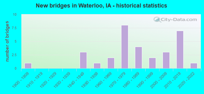
- New bridges - historical statistics
- 11900-1909
- 31940-1949
- 11950-1959
- 21960-1969
- 81970-1979
- 41980-1989
- 21990-1999
- 32000-2009
- 72010-2019
- 12020-2022
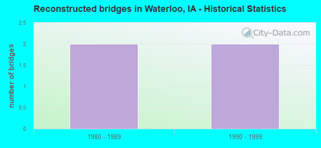
- Reconstructed bridges - Historical Statistics
- 21980-1989
- 21990-1999
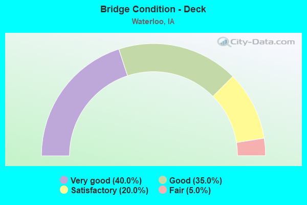
- Bridge Condition - Deck
- 40.0%Very good
- 35.0%Good
- 20.0%Satisfactory
- 5.0%Fair
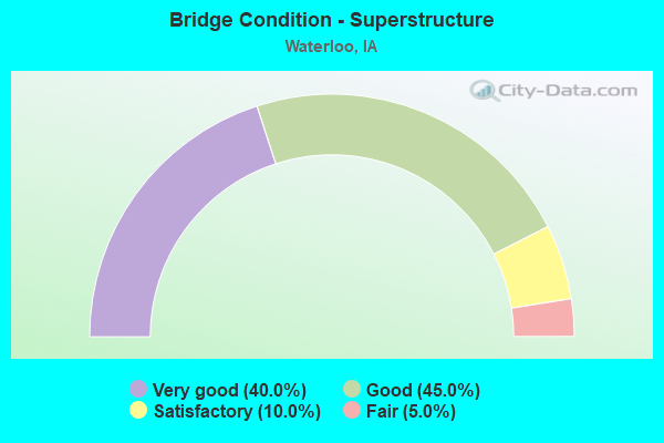
- Bridge Condition - Superstructure
- 40.0%Very good
- 45.0%Good
- 10.0%Satisfactory
- 5.0%Fair
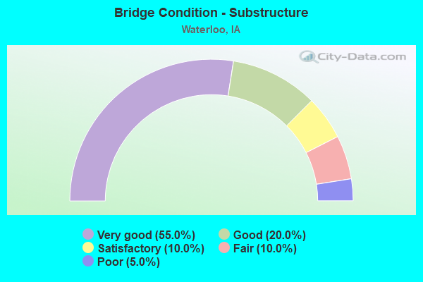
- Bridge Condition - Substructure
- 55.0%Very good
- 20.0%Good
- 10.0%Satisfactory
- 10.0%Fair
- 5.0%Poor
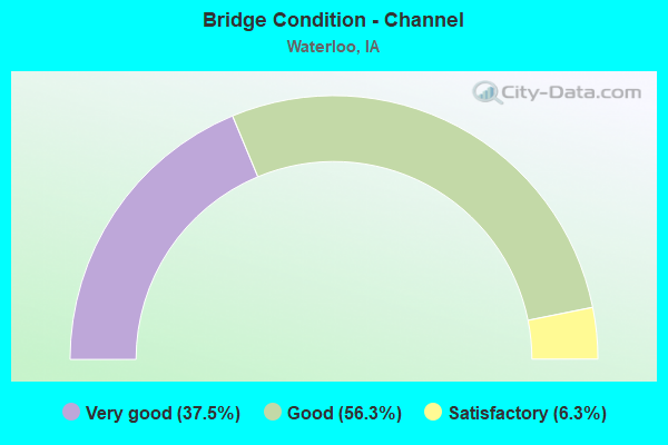
- Bridge Condition - Channel
- 37.5%Very good
- 56.3%Good
- 6.3%Satisfactory
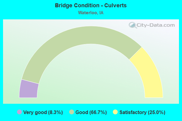
- Bridge Condition - Culverts
- 8.3%Very good
- 66.7%Good
- 25.0%Satisfactory
Find on map >> Show street view
Structure Number: 1511, Location: 0.3 mi. E of Jct. SR V43 (Lat: 42.498122, Lng: -92.252794), Route carried "on" structure: State highway 281, Year Built: 1955, Status: Open, Structure Length: 3.11m (10.20ft), Average Daily Traffic: 970 (year 2020), Truck Traffic: 10%, Average Future Daily Traffic: 970 (year 2042), Design Load: H 20, Features Intersected: ELK RUN CREEK
Minimum Vertical Clearance: 30+ m (98+ ft), Kilometerpoint: 1.302, Lanes on structure: 2, Owner: State Highway Agency, Approaching Roadway Width: 7.3m (24.0ft), Material/Design: Concrete continuous, Design/Construction: Slab, Number Of Spans In Main Unit: 3, Length of Maximum Span: 11.9m (39.0ft), Curb-To-Curb Width: 9.2m (30.2ft), Out-to-Out Width: 11.2m (36.7ft)
Condition: Deck: Fair, Superstructure: Fair, Substructure: Fair, Channel: Satisfactory, Operating Rating: 53.4 metric tons, Method Used To Determine Operating Rating: Load Factor (LF), Inventory Rating: 32.0 metric tons, Method Used To Determine Inventory Rating: Load Factor (LF), Structural Evaluation: Somewhat better than minimum adequacy, Deck Geometry: Equal to present minimum criteria, Waterway Adequacy: Equal to present minimum criteria, Approach Roadway Alignment: Equal to present desirable criteria, Designated Inspection Frequency: Every 21 months, Inspection Date: Febuary 2022, Deck Structure Type: Concrete Cast-file-Place, Wearing Surface/Protective System: Wearing Surface: Low Slump Concrete
Find on map >> Show street view
Structure Number: 75071, Location: 88-12-17-06-10 (Lat: 42.435139, Lng: -92.263569), Route carried "on" structure: County highway , Year Built: 1985, Status: Open, Structure Length: 0.61m (2.00ft), Average Daily Traffic: 280 (year 2017), Average Future Daily Traffic: 280 (year 2040), Design Load: H 20, Features Intersected: SINK CREEK, Facility Carried by Structure: WEIDEN RD
Minimum Vertical Clearance: 30+ m (98+ ft), Kilometerpoint: 2.789, Lanes on structure: 2, Owner: County Highway Agency, Approaching Roadway Width: 7.3m (24.0ft), Material/Design: Wood or Timber, Design/Construction: Stringer/Multi-beam, Number Of Spans In Main Unit: 1, Length of Maximum Span: 5.8m (19.0ft), Curb-To-Curb Width: 7.0m (23.0ft), Out-to-Out Width: 7.3m (24.0ft)
Condition: Deck: Good, Superstructure: Good, Substructure: Good, Channel: Very good, Operating Rating: 45.2 metric tons, Method Used To Determine Operating Rating: Allowable Stress (AS), Inventory Rating: 33.1 metric tons, Method Used To Determine Inventory Rating: Allowable Stress (AS), Structural Evaluation: Better than present minimum criteria, Deck Geometry: Meets minimum limits, Waterway Adequacy: Equal to present desirable criteria, Approach Roadway Alignment: Better than present minimum criteria, Designated Inspection Frequency: Every 24 months, Inspection Date: March 2020, Deck Structure Type: Wood or Timber, Wearing Surface/Protective System: Wearing Surface: Bituminous
Find on map >> Show street view
Structure Number: 75081, Location: 88-12-19-04-10 (Lat: 42.415883, Lng: -92.298011), Route carried "on" structure: County highway , Year Built: 1981, Year Reconstructed: 1996, Status: Open, Structure Length: 0.70m (2.30ft), Average Daily Traffic: 1,490 (year 2021), Average Future Daily Traffic: 1,490 (year 2038), Design Load: HS 20, Features Intersected: TRIB TO MILLER CREEK, Facility Carried by Structure: DYSART RD
Minimum Vertical Clearance: 30+ m (98+ ft), Kilometerpoint: 13.144, Lanes on structure: 2, Owner: County Highway Agency, Approaching Roadway Width: 9.1m (29.9ft), Skew: 1 degrees, Material/Design: Concrete continuous, Design/Construction: Culvert, Number Of Spans In Main Unit: 2, Length of Maximum Span: 3.0m (9.8ft)
Condition: Channel: Very good, Culverts: Satisfactory, Operating Rating: 58.9 metric tons, Method Used To Determine Operating Rating: Load Factor (LF), Inventory Rating: 35.2 metric tons, Method Used To Determine Inventory Rating: Load Factor (LF), Structural Evaluation: Equal to present minimum criteria, Waterway Adequacy: Equal to present desirable criteria, Approach Roadway Alignment: Equal to present desirable criteria, Designated Inspection Frequency: Every 48 months, Inspection Date: March 2018
Find on map >> Show street view
Structure Number: 7521, Location: 88-13-17-04-10 (Lat: 42.431742, Lng: -92.396083), Route carried "on" structure: County highway , Year Built: 1900, Year Reconstructed: 1988, Status: Open, Structure Length: 0.91m (2.99ft), Average Daily Traffic: 30 (year 2017), Average Future Daily Traffic: 30 (year 2040), Features Intersected: PRESCOTTS CREEK, Facility Carried by Structure: HOFF RD
Minimum Vertical Clearance: 30+ m (98+ ft), Kilometerpoint: 0.369, Lanes on structure: 2, Owner: County Highway Agency, Approaching Roadway Width: 7.3m (24.0ft), Material/Design: Steel, Design/Construction: Stringer/Multi-beam, Number Of Spans In Main Unit: 1, Length of Maximum Span: 8.8m (28.9ft), Curb-To-Curb Width: 5.9m (19.4ft), Out-to-Out Width: 6.1m (20.0ft)
Condition: Deck: Satisfactory, Superstructure: Good, Substructure: Fair, Channel: Satisfactory, Operating Rating: 39.8 metric tons, Method Used To Determine Operating Rating: Allowable Stress (AS), Inventory Rating: 23.9 metric tons, Method Used To Determine Inventory Rating: Allowable Stress (AS), Structural Evaluation: Somewhat better than minimum adequacy, Deck Geometry: Meets minimum limits, Waterway Adequacy: Equal to present desirable criteria, Approach Roadway Alignment: Better than present minimum criteria, Designated Inspection Frequency: Every 24 months, Inspection Date: March 2020, Deck Structure Type: Concrete Cast-file-Place, Wearing Surface/Protective System: Wearing Surface: Monolithic Concrete
Find on map >> Show street view
Structure Number: 75221, Location: 88-13-20-01-10 (Lat: 42.428428, Lng: -92.391264), Route carried "on" structure: County highway , Year Built: 2013, Status: Open, Structure Length: 1.23m (4.04ft), Average Daily Traffic: 60 (year 2017), Average Future Daily Traffic: 60 (year 2038), Design Load: HL 93, Features Intersected: PRESCOTTS CREEK, Facility Carried by Structure: W ORANGE RD
Minimum Vertical Clearance: 30+ m (98+ ft), Kilometerpoint: 2.129, Lanes on structure: 2, Owner: County Highway Agency, Approaching Roadway Width: 8.5m (27.9ft), Material/Design: Steel, Design/Construction: Stringer/Multi-beam, Number Of Spans In Main Unit: 1, Length of Maximum Span: 11.9m (39.0ft), Curb-To-Curb Width: 9.1m (29.9ft), Out-to-Out Width: 9.3m (30.5ft)
Condition: Deck: Very good, Superstructure: Very good, Substructure: Very good, Channel: Very good, Operating Rating: 48.3 metric tons, Method Used To Determine Operating Rating: Load and Resistance Factor Rating (LRFR) rating reported by rating factor(RF) method using HL-93 loadings, Inventory Rating: 37.3 metric tons, Method Used To Determine Inventory Rating: Load and Resistance Factor Rating (LRFR) rating reported by rating factor(RF) method using HL-93 loadings, Structural Evaluation: Equal to present desirable criteria, Deck Geometry: Better than present minimum criteria, Waterway Adequacy: Superior to present desirable criteria, Approach Roadway Alignment: Equal to present desirable criteria, Designated Inspection Frequency: Every 48 months, Inspection Date: March 2018, Deck Structure Type: Concrete Cast-file-Place, Wearing Surface/Protective System: Wearing Surface: Monolithic Concrete
Find on map >> Show street view
Structure Number: 75241, Location: 88-13-25-01-10 (Lat: 42.414086, Lng: -92.299897), Route carried "on" structure: County highway , Year Built: 1977, Status: Open, Structure Length: 0.79m (2.59ft), Average Daily Traffic: 470 (year 2021), Average Future Daily Traffic: 470 (year 2040), Features Intersected: TRIB TO MILLER CREEK, Facility Carried by Structure: E WASHBURN RD
Minimum Vertical Clearance: 30+ m (98+ ft), Kilometerpoint: 4.712, Lanes on structure: 2, Owner: County Highway Agency, Approaching Roadway Width: 9.8m (32.2ft), Skew: 3 degrees, Material/Design: Concrete continuous, Design/Construction: Culvert, Number Of Spans In Main Unit: 2, Length of Maximum Span: 3.7m (12.1ft)
Condition: Channel: Good, Culverts: Good, Operating Rating: 44.8 metric tons, Method Used To Determine Operating Rating: Load Factor (LF), Inventory Rating: 26.8 metric tons, Method Used To Determine Inventory Rating: Load Factor (LF), Structural Evaluation: Equal to present minimum criteria, Waterway Adequacy: Equal to present desirable criteria, Approach Roadway Alignment: Equal to present desirable criteria, Designated Inspection Frequency: Every 24 months, Inspection Date: March 2020
Find on map >> Show street view
Structure Number: 75291, Location: 88-13-34-02-10 (Lat: 42.396919, Lng: -92.357456), Route carried "on" structure: County highway , Year Built: 1971, Status: Open, Structure Length: 0.82m (2.69ft), Average Daily Traffic: 440 (year 2021), Truck Traffic: 6%, Average Future Daily Traffic: 440 (year 2040), Features Intersected: TRIB TO MILLER CREEK, Facility Carried by Structure: KIMBALL AVE
Minimum Vertical Clearance: 30+ m (98+ ft), Kilometerpoint: 11.048, Lanes on structure: 2, Owner: County Highway Agency, Approaching Roadway Width: 9.1m (29.9ft), Material/Design: Concrete continuous, Design/Construction: Culvert, Number Of Spans In Main Unit: 2, Length of Maximum Span: 3.7m (12.1ft)
Condition: Channel: Very good, Culverts: Good, Operating Rating: 32.5 metric tons, Method Used To Determine Operating Rating: Load Factor (LF), Inventory Rating: 19.5 metric tons, Method Used To Determine Inventory Rating: Load Factor (LF), Structural Evaluation: Somewhat better than minimum adequacy, Waterway Adequacy: Equal to present desirable criteria, Approach Roadway Alignment: Equal to present desirable criteria, Designated Inspection Frequency: Every 24 months, Inspection Date: March 2020
Find on map >> Show street view
Structure Number: 75301, Location: 88-13-35-02-10 (Lat: 42.387933, Lng: -92.337883), Route carried "on" structure: County highway , Year Built: 2017, Status: Open, Structure Length: 2.83m (9.28ft), Average Daily Traffic: 100 (year 2017), Average Future Daily Traffic: 100 (year 2041), Design Load: HL 93, Features Intersected: TRIB TO MILLER CREEK, Facility Carried by Structure: HAMMOND AVE
Minimum Vertical Clearance: 30+ m (98+ ft), Kilometerpoint: 10.049, Lanes on structure: 2, Owner: County Highway Agency, Approaching Roadway Width: 7.9m (25.9ft), Material/Design: Concrete continuous, Design/Construction: Slab, Number Of Spans In Main Unit: 3, Length of Maximum Span: 10.7m (35.1ft), Curb-To-Curb Width: 9.1m (29.9ft), Out-to-Out Width: 10.1m (33.1ft)
Condition: Deck: Very good, Superstructure: Very good, Substructure: Very good, Channel: Good, Operating Rating: 50.5 metric tons, Method Used To Determine Operating Rating: Load and Resistance Factor Rating (LRFR) rating reported by rating factor(RF) method using HL-93 loadings, Inventory Rating: 38.9 metric tons, Method Used To Determine Inventory Rating: Load and Resistance Factor Rating (LRFR) rating reported by rating factor(RF) method using HL-93 loadings, Structural Evaluation: Equal to present desirable criteria, Deck Geometry: Better than present minimum criteria, Waterway Adequacy: Better than present minimum criteria, Approach Roadway Alignment: Equal to present desirable criteria, Designated Inspection Frequency: Every 48 months, Inspection Date: November 2021, Deck Structure Type: Concrete Cast-file-Place, Wearing Surface/Protective System: Wearing Surface: Monolithic Concrete
Find on map >> Show street view
Structure Number: 75671, Location: 89-12-01-02-10 (Lat: 42.542619, Lng: -92.219017), Route carried "on" structure: County highway , Year Built: 1996, Status: Open, Structure Length: 1.59m (5.22ft), Average Daily Traffic: 2,460 (year 2021), Average Future Daily Traffic: 2,460 (year 2040), Design Load: HS 20, Features Intersected: TRIB TO ELK RUN CREEK, Facility Carried by Structure: N RAYMOND RD
Minimum Vertical Clearance: 30+ m (98+ ft), Kilometerpoint: 4.989, Lanes on structure: 2, Owner: County Highway Agency, Approaching Roadway Width: 9.8m (32.2ft), Skew: 4 degrees, Material/Design: Concrete continuous, Design/Construction: Culvert, Number Of Spans In Main Unit: 3, Length of Maximum Span: 5.2m (17.1ft)
Condition: Channel: Good, Culverts: Good, Operating Rating: 46.8 metric tons, Method Used To Determine Operating Rating: Load Factor (LF), Inventory Rating: 28.0 metric tons, Method Used To Determine Inventory Rating: Load Factor (LF), Structural Evaluation: Better than present minimum criteria, Waterway Adequacy: Equal to present minimum criteria, Approach Roadway Alignment: Better than present minimum criteria, Designated Inspection Frequency: Every 24 months, Inspection Date: November 2020
Find on map >> Show street view
Structure Number: 7571, Location: 89-12-03-01-10 (Lat: 42.555878, Lng: -92.249311), Route carried "on" structure: County highway , Year Built: 1963, Status: Open, Structure Length: 1.34m (4.40ft), Average Daily Traffic: 50 (year 2017), Average Future Daily Traffic: 50 (year 2040), Design Load: H 20, Features Intersected: ELK RUN CREEK, Facility Carried by Structure: E BIG ROCK RD
Minimum Vertical Clearance: 30+ m (98+ ft), Kilometerpoint: 6.025, Lanes on structure: 2, Owner: County Highway Agency, Approaching Roadway Width: 8.5m (27.9ft), Material/Design: Prestressed concrete, Design/Construction: Stringer/Multi-beam, Number Of Spans In Main Unit: 1, Length of Maximum Span: 13.1m (43.0ft), Curb-To-Curb Width: 8.6m (28.2ft), Out-to-Out Width: 9.2m (30.2ft)
Condition: Deck: Good, Superstructure: Good, Substructure: Satisfactory, Channel: Good, Operating Rating: 51.1 metric tons, Method Used To Determine Operating Rating: Allowable Stress (AS), Inventory Rating: 33.0 metric tons, Method Used To Determine Inventory Rating: Allowable Stress (AS), Structural Evaluation: Equal to present minimum criteria, Deck Geometry: Better than present minimum criteria, Waterway Adequacy: Better than present minimum criteria, Approach Roadway Alignment: Equal to present minimum criteria, Designated Inspection Frequency: Every 24 months, Inspection Date: November 2020, Deck Structure Type: Concrete Cast-file-Place, Wearing Surface/Protective System: Wearing Surface: Monolithic Concrete
Find on map >> Show street view
Structure Number: 75721, Location: 89-12-03-02-10 (Lat: 42.546775, Lng: -92.258392), Route carried "on" structure: County highway , Year Built: 1974, Status: Open, Structure Length: 0.67m (2.20ft), Average Daily Traffic: 1,490 (year 2021), Average Future Daily Traffic: 1,490 (year 2038), Design Load: H 20, Features Intersected: TRIB TO ELK RUN CREEK, Facility Carried by Structure: N ELK RUN RD
Minimum Vertical Clearance: 30+ m (98+ ft), Kilometerpoint: 3.524, Lanes on structure: 2, Owner: County Highway Agency, Approaching Roadway Width: 11.6m (38.1ft), Skew: 3 degrees, Material/Design: Concrete continuous, Design/Construction: Culvert, Number Of Spans In Main Unit: 2, Length of Maximum Span: 3.7m (12.1ft)
Condition: Channel: Good, Culverts: Good, Operating Rating: 58.4 metric tons, Method Used To Determine Operating Rating: Load Factor (LF), Inventory Rating: 35.0 metric tons, Method Used To Determine Inventory Rating: Load Factor (LF), Structural Evaluation: Better than present minimum criteria, Waterway Adequacy: Better than present minimum criteria, Approach Roadway Alignment: Better than present minimum criteria, Designated Inspection Frequency: Every 48 months, Inspection Date: November 2018
Find on map >> Show street view
Structure Number: 7573, Location: 89-12-06-01-10 (Lat: 42.555881, Lng: -92.312122), Route carried "on" structure: County highway , Year Built: 1949, Year Reconstructed: 2003, Status: Open, Structure Length: 0.94m (3.08ft), Average Daily Traffic: 30 (year 2017), Average Future Daily Traffic: 30 (year 2040), Design Load: HS 20, Features Intersected: VIRDEN CREEK, Facility Carried by Structure: E BIG ROCK RD
Minimum Vertical Clearance: 30+ m (98+ ft), Kilometerpoint: 0.869, Lanes on structure: 2, Owner: County Highway Agency, Approaching Roadway Width: 7.3m (24.0ft), Material/Design: Steel, Design/Construction: Stringer/Multi-beam, Number Of Spans In Main Unit: 1, Length of Maximum Span: 8.8m (28.9ft), Curb-To-Curb Width: 6.6m (21.7ft), Out-to-Out Width: 7.2m (23.6ft)
Condition: Deck: Good, Superstructure: Good, Substructure: Good, Channel: Good, Operating Rating: 46.0 metric tons, Method Used To Determine Operating Rating: Allowable Stress (AS), Inventory Rating: 32.9 metric tons, Method Used To Determine Inventory Rating: Allowable Stress (AS), Structural Evaluation: Better than present minimum criteria, Deck Geometry: Somewhat better than minimum adequacy, Waterway Adequacy: Better than present minimum criteria, Approach Roadway Alignment: Equal to present desirable criteria, Designated Inspection Frequency: Every 24 months, Inspection Date: November 2020, Deck Structure Type: Wood or Timber, Wearing Surface/Protective System: Wearing Surface: Gravel
Find on map >> Show street view
Structure Number: 75741, Location: 89-12-07-01-10 (Lat: 42.541969, Lng: -92.313803), Route carried "on" structure: County highway , Year Built: 2016, Status: Open, Structure Length: 1.23m (4.04ft), Average Daily Traffic: 120 (year 2017), Average Future Daily Traffic: 120 (year 2040), Design Load: HS 20, Features Intersected: VIRDEN CREEK, Facility Carried by Structure: E AIRLINE HWY
Minimum Vertical Clearance: 30+ m (98+ ft), Kilometerpoint: 0.740, Lanes on structure: 2, Owner: County Highway Agency, Approaching Roadway Width: 7.9m (25.9ft), Material/Design: Steel, Design/Construction: Stringer/Multi-beam, Number Of Spans In Main Unit: 1, Length of Maximum Span: 11.9m (39.0ft), Curb-To-Curb Width: 9.1m (29.9ft), Out-to-Out Width: 9.3m (30.5ft)
Condition: Deck: Very good, Superstructure: Very good, Substructure: Very good, Channel: Very good, Operating Rating: 48.3 metric tons, Method Used To Determine Operating Rating: Load and Resistance Factor Rating (LRFR) rating reported by rating factor(RF) method using HL-93 loadings, Inventory Rating: 37.3 metric tons, Method Used To Determine Inventory Rating: Load and Resistance Factor Rating (LRFR) rating reported by rating factor(RF) method using HL-93 loadings, Structural Evaluation: Equal to present desirable criteria, Deck Geometry: Equal to present minimum criteria, Waterway Adequacy: Superior to present desirable criteria, Approach Roadway Alignment: Equal to present desirable criteria, Designated Inspection Frequency: Every 48 months, Inspection Date: November 2020, Deck Structure Type: Concrete Cast-file-Place, Wearing Surface/Protective System: Wearing Surface: Monolithic Concrete
Find on map >> Show street view
Structure Number: 75751, Location: 89-12-07-02-10 (Lat: 42.539467, Lng: -92.317842), Route carried "on" structure: County highway , Year Built: 1983, Status: Open, Structure Length: 0.67m (2.20ft), Average Daily Traffic: 80 (year 2021), Average Future Daily Traffic: 80 (year 2040), Design Load: HS 20, Features Intersected: VIRDEN CREEK, Facility Carried by Structure: MOLINE RD
Minimum Vertical Clearance: 30+ m (98+ ft), Kilometerpoint: 0.835, Lanes on structure: 2, Owner: County Highway Agency, Approaching Roadway Width: 7.3m (24.0ft), Skew: 1 degrees, Material/Design: Concrete continuous, Design/Construction: Culvert, Number Of Spans In Main Unit: 3, Length of Maximum Span: 1.8m (5.9ft)
Condition: Channel: Good, Culverts: Good, Operating Rating: 36.6 metric tons, Method Used To Determine Operating Rating: Load and Resistance Factor Rating (LRFR) rating reported by rating factor(RF) method using HL-93 loadings, Inventory Rating: 28.2 metric tons, Method Used To Determine Inventory Rating: Load and Resistance Factor Rating (LRFR) rating reported by rating factor(RF) method using HL-93 loadings, Structural Evaluation: Better than present minimum criteria, Waterway Adequacy: Equal to present minimum criteria, Approach Roadway Alignment: Better than present minimum criteria, Designated Inspection Frequency: Every 24 months, Inspection Date: November 2020
Find on map >> Show street view
Structure Number: 75761, Location: 89-12-11-01-10 (Lat: 42.541703, Lng: -92.220111), Route carried "on" structure: County highway , Year Built: 2000, Status: Open, Structure Length: 1.40m (4.59ft), Average Daily Traffic: 15 (year 2021), Truck Traffic: 27%, Average Future Daily Traffic: 15 (year 2038), Design Load: HS 20+Mod, Features Intersected: TRIB TO ELK RUN CREEK, Facility Carried by Structure: E AIRLINE HWY
Minimum Vertical Clearance: 30+ m (98+ ft), Kilometerpoint: 5.467, Lanes on structure: 2, Owner: County Highway Agency, Approaching Roadway Width: 7.3m (24.0ft), Skew: 3 degrees, Material/Design: Prestressed concrete, Design/Construction: Tee Beam, Number Of Spans In Main Unit: 1, Length of Maximum Span: 13.7m (44.9ft), Curb-To-Curb Width: 9.8m (32.2ft), Out-to-Out Width: 9.8m (32.2ft)
Condition: Deck: Very good, Superstructure: Very good, Substructure: Very good, Channel: Very good, Operating Rating: 47.5 metric tons, Method Used To Determine Operating Rating: Load Factor (LF), Inventory Rating: 34.7 metric tons, Method Used To Determine Inventory Rating: Load Factor (LF), Structural Evaluation: Equal to present desirable criteria, Deck Geometry: Equal to present desirable criteria, Waterway Adequacy: Equal to present desirable criteria, Approach Roadway Alignment: Equal to present desirable criteria, Designated Inspection Frequency: Every 48 months, Inspection Date: November 2018, Deck Structure Type: Concrete Precast Panels, Wearing Surface/Protective System: Wearing Surface: Other
Find on map >> Show street view
Structure Number: 75771, Location: 89-12-13-01-10 (Lat: 42.526992, Lng: -92.207650), Route carried "on" structure: County highway , Year Built: 2012, Status: Open, Structure Length: 1.23m (4.04ft), Average Daily Traffic: 110 (year 2021), Truck Traffic: 12%, Average Future Daily Traffic: 110 (year 2038), Design Load: HL 93, Features Intersected: TRIB TO ELK RUN CREEK, Facility Carried by Structure: E DONALD ST
Minimum Vertical Clearance: 30+ m (98+ ft), Kilometerpoint: 7.393, Lanes on structure: 2, Owner: County Highway Agency, Approaching Roadway Width: 8.5m (27.9ft), Material/Design: Steel, Design/Construction: Stringer/Multi-beam, Number Of Spans In Main Unit: 1, Length of Maximum Span: 11.9m (39.0ft), Curb-To-Curb Width: 9.1m (29.9ft), Out-to-Out Width: 9.3m (30.5ft)
Condition: Deck: Very good, Superstructure: Very good, Substructure: Very good, Channel: Very good, Operating Rating: 48.3 metric tons, Method Used To Determine Operating Rating: Load and Resistance Factor Rating (LRFR) rating reported by rating factor(RF) method using HL-93 loadings, Inventory Rating: 37.3 metric tons, Method Used To Determine Inventory Rating: Load and Resistance Factor Rating (LRFR) rating reported by rating factor(RF) method using HL-93 loadings, Structural Evaluation: Equal to present desirable criteria, Deck Geometry: Equal to present minimum criteria, Waterway Adequacy: Equal to present desirable criteria, Approach Roadway Alignment: Equal to present desirable criteria, Designated Inspection Frequency: Every 48 months, Inspection Date: November 2018, Deck Structure Type: Concrete Cast-file-Place, Wearing Surface/Protective System: Wearing Surface: Monolithic Concrete
Find on map >> Show street view
Structure Number: 75781, Location: 89-12-13-02-10 (Lat: 42.526225, Lng: -92.219367), Route carried "on" structure: County highway , Year Built: 1973, Status: Open, Structure Length: 1.55m (5.09ft), Average Daily Traffic: 2,300 (year 2021), Truck Traffic: 4%, Average Future Daily Traffic: 2,300 (year 2038), Design Load: HS 20, Features Intersected: TRIB TO ELK RUN CREEK, Facility Carried by Structure: N RAYMOND RD
Minimum Vertical Clearance: 30+ m (98+ ft), Kilometerpoint: 3.167, Lanes on structure: 2, Owner: County Highway Agency, Approaching Roadway Width: 7.3m (24.0ft), Material/Design: Concrete continuous, Design/Construction: Culvert, Number Of Spans In Main Unit: 3, Length of Maximum Span: 5.5m (18.0ft)
Condition: Channel: Good, Culverts: Satisfactory, Operating Rating: 45.4 metric tons, Method Used To Determine Operating Rating: Load Factor (LF), Inventory Rating: 27.1 metric tons, Method Used To Determine Inventory Rating: Load Factor (LF), Structural Evaluation: Equal to present minimum criteria, Waterway Adequacy: Better than present minimum criteria, Approach Roadway Alignment: Better than present minimum criteria, Designated Inspection Frequency: Every 48 months, Inspection Date: November 2018
Find on map >> Show street view
Structure Number: 75791, Location: 89-12-14-03-10 (Lat: 42.527147, Lng: -92.230211), Route carried "on" structure: County highway , Year Built: 1971, Status: Open, Structure Length: 1.01m (3.31ft), Average Daily Traffic: 1,400 (year 2021), Average Future Daily Traffic: 1,400 (year 2040), Design Load: H 15, Features Intersected: TRIB TO ELK RUN CREEK, Facility Carried by Structure: E DONALD ST
Minimum Vertical Clearance: 30+ m (98+ ft), Kilometerpoint: 5.541, Lanes on structure: 2, Owner: County Highway Agency, Approaching Roadway Width: 12.2m (40.0ft), Skew: 3 degrees, Material/Design: Concrete continuous, Design/Construction: Culvert, Number Of Spans In Main Unit: 3, Length of Maximum Span: 3.7m (12.1ft)
Condition: Channel: Good, Culverts: Satisfactory, Operating Rating: 39.5 metric tons, Method Used To Determine Operating Rating: Load Factor (LF), Inventory Rating: 23.7 metric tons, Method Used To Determine Inventory Rating: Load Factor (LF), Structural Evaluation: Equal to present minimum criteria, Waterway Adequacy: Better than present minimum criteria, Approach Roadway Alignment: Equal to present desirable criteria, Designated Inspection Frequency: Every 24 months, Inspection Date: November 2020
Find on map >> Show street view
Structure Number: 75801, Location: 89-12-15-01-10 (Lat: 42.527164, Lng: -92.239786), Route carried "on" structure: County highway , Year Built: 1971, Status: Open, Structure Length: 3.05m (10.01ft), Average Daily Traffic: 1,400 (year 2021), Average Future Daily Traffic: 1,400 (year 2040), Design Load: H 20, Features Intersected: ELK RUN CREEK, Facility Carried by Structure: E DONALD ST
Minimum Vertical Clearance: 30+ m (98+ ft), Kilometerpoint: 4.754, Lanes on structure: 2, Owner: County Highway Agency, Approaching Roadway Width: 12.2m (40.0ft), Material/Design: Concrete continuous, Design/Construction: Slab, Number Of Spans In Main Unit: 3, Length of Maximum Span: 11.9m (39.0ft), Curb-To-Curb Width: 9.1m (29.9ft), Out-to-Out Width: 9.8m (32.2ft)
Condition: Deck: Satisfactory, Superstructure: Satisfactory, Substructure: Good, Channel: Good, Operating Rating: 49.8 metric tons, Method Used To Determine Operating Rating: Allowable Stress (AS), Inventory Rating: 30.0 metric tons, Method Used To Determine Inventory Rating: Allowable Stress (AS), Structural Evaluation: Equal to present minimum criteria, Deck Geometry: Somewhat better than minimum adequacy, Waterway Adequacy: Better than present minimum criteria, Approach Roadway Alignment: Better than present minimum criteria, Designated Inspection Frequency: Every 24 months, Inspection Date: November 2020, Bridge Improvement Cost: $1,000, Roadway Improvement Cost: $1,000, Deck Structure Type: Concrete Cast-file-Place, Wearing Surface/Protective System: Wearing Surface: Monolithic Concrete
Find on map >> Show street view
Structure Number: 7581, Location: 89-12-22-03-10 (Lat: 42.512647, Lng: -92.244656), Route carried "on" structure: County highway , Year Built: 1970, Status: Open, Structure Length: 3.81m (12.50ft), Average Daily Traffic: 100 (year 2017), Average Future Daily Traffic: 100 (year 2040), Features Intersected: ELK RUN CREEK, Facility Carried by Structure: NEWELL ST
Minimum Vertical Clearance: 30+ m (98+ ft), Kilometerpoint: 0.463, Lanes on structure: 2, Owner: County Highway Agency, Approaching Roadway Width: 7.9m (25.9ft), Material/Design: Concrete continuous, Design/Construction: Slab, Number Of Spans In Main Unit: 3, Length of Maximum Span: 14.9m (48.9ft), Curb-To-Curb Width: 7.3m (24.0ft), Out-to-Out Width: 8.0m (26.2ft)
Condition: Deck: Satisfactory, Superstructure: Satisfactory, Substructure: Satisfactory, Channel: Good, Operating Rating: 37.2 metric tons, Method Used To Determine Operating Rating: Load Factor (LF), Inventory Rating: 22.3 metric tons, Method Used To Determine Inventory Rating: Load Factor (LF), Structural Evaluation: Equal to present minimum criteria, Deck Geometry: Equal to present minimum criteria, Waterway Adequacy: Better than present minimum criteria, Approach Roadway Alignment: Better than present minimum criteria, Designated Inspection Frequency: Every 24 months, Inspection Date: November 2020, Deck Structure Type: Concrete Cast-file-Place, Wearing Surface/Protective System: Wearing Surface: Monolithic Concrete
Find on map >> Show street view
Structure Number: 76321, Location: 90-12-16-02-10 (Lat: 42.604031, Lng: -92.278286), Route carried "on" structure: County highway , Year Built: 2006, Status: Open, Structure Length: 2.38m (7.81ft), Average Daily Traffic: 40 (year 2021), Average Future Daily Traffic: 40 (year 2038), Design Load: HS 20, Features Intersected: TRIB TO CRANE CREEK, Facility Carried by Structure: SCHENK RD
Minimum Vertical Clearance: 30+ m (98+ ft), Kilometerpoint: 8.505, Lanes on structure: 2, Owner: County Highway Agency, Approaching Roadway Width: 9.1m (29.9ft), Material/Design: Concrete continuous, Design/Construction: Slab, Number Of Spans In Main Unit: 3, Length of Maximum Span: 8.8m (28.9ft), Curb-To-Curb Width: 9.3m (30.5ft), Out-to-Out Width: 10.1m (33.1ft)
Condition: Deck: Good, Superstructure: Good, Substructure: Very good, Channel: Very good, Operating Rating: 81.1 metric tons, Method Used To Determine Operating Rating: Load Factor (LF), Inventory Rating: 45.7 metric tons, Method Used To Determine Inventory Rating: Load Factor (LF), Structural Evaluation: Better than present minimum criteria, Deck Geometry: Better than present minimum criteria, Waterway Adequacy: Equal to present desirable criteria, Approach Roadway Alignment: Equal to present desirable criteria, Designated Inspection Frequency: Every 48 months, Inspection Date: November 2018, Deck Structure Type: Concrete Cast-file-Place, Wearing Surface/Protective System: Wearing Surface: Monolithic Concrete
Find on map >> Show street view
Structure Number: 76411, Location: 90-12-34-01-10 (Lat: 42.570408, Lng: -92.255633), Route carried "on" structure: County highway , Year Built: 1984, Status: Open, Structure Length: 0.76m (2.49ft), Average Daily Traffic: 1,540 (year 2021), Average Future Daily Traffic: 1,540 (year 2038), Design Load: HS 20, Features Intersected: ELK RUN CREEK, Facility Carried by Structure: E DUNKERTON RD
Minimum Vertical Clearance: 30+ m (98+ ft), Kilometerpoint: 6.722, Lanes on structure: 2, Owner: County Highway Agency, Approaching Roadway Width: 7.0m (23.0ft), Material/Design: Concrete continuous, Design/Construction: Culvert, Number Of Spans In Main Unit: 2, Length of Maximum Span: 3.7m (12.1ft)
Condition: Channel: Good, Culverts: Good, Operating Rating: 66.8 metric tons, Method Used To Determine Operating Rating: Load Factor (LF), Inventory Rating: 40.0 metric tons, Method Used To Determine Inventory Rating: Load Factor (LF), Structural Evaluation: Better than present minimum criteria, Waterway Adequacy: Better than present minimum criteria, Approach Roadway Alignment: Better than present minimum criteria, Designated Inspection Frequency: Every 48 months, Inspection Date: November 2018
Find on map >> Show street view
Structure Number: 76421, Location: 90-12-35-02-10 (Lat: 42.564039, Lng: -92.238867), Route carried "on" structure: County highway , Year Built: 1967, Status: Open, Structure Length: 0.82m (2.69ft), Average Daily Traffic: 30 (year 2017), Average Future Daily Traffic: 30 (year 2040), Features Intersected: TRIB TO ELK RUN CREEK, Facility Carried by Structure: CRANE CREEK RD
Minimum Vertical Clearance: 30+ m (98+ ft), Kilometerpoint: 4.096, Lanes on structure: 2, Owner: County Highway Agency, Approaching Roadway Width: 7.3m (24.0ft), Material/Design: Steel, Design/Construction: Culvert, Number Of Spans In Main Unit: 3, Length of Maximum Span: 2.7m (8.9ft)
Condition: Channel: Good, Culverts: Good, Operating Rating: 24.5 metric tons, Method Used To Determine Operating Rating: Field evaluation and documented engineering judgment, Inventory Rating: 18.1 metric tons, Method Used To Determine Inventory Rating: Field evaluation and documented engineering judgment, Structural Evaluation: Somewhat better than minimum adequacy, Waterway Adequacy: Better than present minimum criteria, Approach Roadway Alignment: Better than present minimum criteria, Designated Inspection Frequency: Every 24 months, Inspection Date: November 2020
Find on map >> Show street view
Structure Number: 76551, Location: 90-13-16-02-10 (Lat: 42.606072, Lng: -92.396708), Route carried "on" structure: County highway , Year Built: 1999, Status: Open, Structure Length: 0.76m (2.49ft), Average Daily Traffic: 80 (year 2021), Average Future Daily Traffic: 80 (year 2038), Design Load: HS 20, Features Intersected: TRIB TO CEDAR RIVER, Facility Carried by Structure: STREETER RD
Minimum Vertical Clearance: 30+ m (98+ ft), Kilometerpoint: 3.951, Lanes on structure: 2, Owner: County Highway Agency, Approaching Roadway Width: 7.3m (24.0ft), Skew: 4 degrees, Material/Design: Steel, Design/Construction: Stringer/Multi-beam, Number Of Spans In Main Unit: 1, Length of Maximum Span: 7.0m (23.0ft), Curb-To-Curb Width: 9.4m (30.8ft), Out-to-Out Width: 9.4m (30.8ft)
Condition: Deck: Good, Superstructure: Good, Substructure: Very good, Channel: Good, Inventory Rating: 74.0 metric tons, Method Used To Determine Inventory Rating: Allowable Stress (AS), Structural Evaluation: Better than present minimum criteria, Deck Geometry: Better than present minimum criteria, Waterway Adequacy: Equal to present desirable criteria, Approach Roadway Alignment: Equal to present desirable criteria, Designated Inspection Frequency: Every 48 months, Inspection Date: November 2018, Deck Structure Type: Concrete Cast-file-Place
Find on map >> Show street view
Structure Number: 7662, Location: 90-13-21-01-10 (Lat: 42.599800, Lng: -92.385083), Route carried "on" structure: County highway , Year Built: 1948, Status: Open, Structure Length: 0.67m (2.20ft), Average Daily Traffic: 30 (year 2021), Average Future Daily Traffic: 30 (year 2040), Features Intersected: TRIB TO CEDAR RIVER, Facility Carried by Structure: W BENNINGTON RD
Minimum Vertical Clearance: 30+ m (98+ ft), Kilometerpoint: 7.607, Lanes on structure: 2, Owner: County Highway Agency, Approaching Roadway Width: 6.7m (22.0ft), Material/Design: Steel, Design/Construction: Stringer/Multi-beam, Number Of Spans In Main Unit: 1, Length of Maximum Span: 6.4m (21.0ft), Curb-To-Curb Width: 6.0m (19.7ft), Out-to-Out Width: 6.2m (20.3ft)
Condition: Deck: Satisfactory, Superstructure: Good, Substructure: Good, Channel: Good, Operating Rating: 42.2 metric tons, Method Used To Determine Operating Rating: Load Factor (LF), Inventory Rating: 25.3 metric tons, Method Used To Determine Inventory Rating: Load Factor (LF), Structural Evaluation: Equal to present minimum criteria, Deck Geometry: Meets minimum limits, Waterway Adequacy: Equal to present desirable criteria, Approach Roadway Alignment: Equal to present minimum criteria, Designated Inspection Frequency: Every 24 months, Inspection Date: November 2020, Deck Structure Type: Concrete Cast-file-Place, Wearing Surface/Protective System: Wearing Surface: Monolithic Concrete
Find on map >> Show street view
Structure Number: 76631, Location: 90-13-22-02-10 (Lat: 42.587128, Lng: -92.377122), Route carried "on" structure: County highway , Year Built: 1974, Status: Open, Structure Length: 0.82m (2.69ft), Average Daily Traffic: 950 (year 2021), Average Future Daily Traffic: 950 (year 2040), Design Load: H 20, Features Intersected: TRIB TO CEDAR RIVER, Facility Carried by Structure: WAGNER RD
Minimum Vertical Clearance: 30+ m (98+ ft), Kilometerpoint: 2.643, Lanes on structure: 2, Owner: County Highway Agency, Approaching Roadway Width: 10.4m (34.1ft), Material/Design: Concrete continuous, Design/Construction: Culvert, Number Of Spans In Main Unit: 2, Length of Maximum Span: 3.7m (12.1ft)
Condition: Channel: Good, Culverts: Good, Operating Rating: 53.9 metric tons, Method Used To Determine Operating Rating: Load Factor (LF), Inventory Rating: 32.3 metric tons, Method Used To Determine Inventory Rating: Load Factor (LF), Structural Evaluation: Better than present minimum criteria, Waterway Adequacy: Equal to present desirable criteria, Approach Roadway Alignment: Equal to present desirable criteria, Designated Inspection Frequency: Every 24 months, Inspection Date: November 2020
Find on map >> Show street view
Structure Number: 76651, Location: 90-13-26-02-10 (Lat: 42.573889, Lng: -92.357350), Route carried "on" structure: County highway , Year Built: 2016, Status: Open, Structure Length: 0.70m (2.30ft), Average Daily Traffic: 50 (year 2017), Average Future Daily Traffic: 50 (year 2040), Design Load: HL 93, Features Intersected: TRIB TO CEDAR RIVER, Facility Carried by Structure: BURTON RD
Minimum Vertical Clearance: 30+ m (98+ ft), Kilometerpoint: 1.168, Lanes on structure: 2, Owner: County Highway Agency, Approaching Roadway Width: 7.9m (25.9ft), Material/Design: Concrete continuous, Design/Construction: Culvert, Length of Maximum Span: 3.0m (9.8ft), Curb-To-Curb Width: 8.5m (27.9ft), Out-to-Out Width: 9.1m (29.9ft)
Condition: Channel: Very good, Culverts: Very good, Operating Rating: 43.1 metric tons, Method Used To Determine Operating Rating: Load and Resistance Factor Rating (LRFR) rating reported by rating factor(RF) method using HL-93 loadings, Inventory Rating: 33.4 metric tons, Method Used To Determine Inventory Rating: Load and Resistance Factor Rating (LRFR) rating reported by rating factor(RF) method using HL-93 loadings, Structural Evaluation: Equal to present desirable criteria, Deck Geometry: Better than present minimum criteria, Waterway Adequacy: Equal to present desirable criteria, Approach Roadway Alignment: Equal to present desirable criteria, Designated Inspection Frequency: Every 24 months, Inspection Date: November 2020, Wearing Surface/Protective System: Wearing Surface: Gravel
Find on map >> Show street view
Structure Number: 76671, Location: 90-13-28-01-10 (Lat: 42.585156, Lng: -92.387125), Route carried "on" structure: County highway , Year Built: 2006, Status: Open, Structure Length: 1.25m (4.10ft), Average Daily Traffic: 25 (year 2021), Average Future Daily Traffic: 25 (year 2038), Design Load: HS 20, Features Intersected: TRIB TO CEDAR RIVER, Facility Carried by Structure: W MT VERNON RD
Minimum Vertical Clearance: 30+ m (98+ ft), Kilometerpoint: 7.067, Lanes on structure: 2, Owner: County Highway Agency, Approaching Roadway Width: 9.1m (29.9ft), Skew: 4 degrees, Material/Design: Steel, Design/Construction: Stringer/Multi-beam, Number Of Spans In Main Unit: 1, Length of Maximum Span: 11.9m (39.0ft), Curb-To-Curb Width: 9.5m (31.2ft), Out-to-Out Width: 9.7m (31.8ft)
Condition: Deck: Good, Superstructure: Very good, Substructure: Very good, Channel: Good, Operating Rating: 87.0 metric tons, Method Used To Determine Operating Rating: Allowable Stress (AS), Inventory Rating: 55.5 metric tons, Method Used To Determine Inventory Rating: Allowable Stress (AS), Structural Evaluation: Equal to present desirable criteria, Deck Geometry: Better than present minimum criteria, Waterway Adequacy: Equal to present desirable criteria, Approach Roadway Alignment: Equal to present desirable criteria, Designated Inspection Frequency: Every 48 months, Inspection Date: November 2018, Deck Structure Type: Concrete Cast-file-Place, Wearing Surface/Protective System: Wearing Surface: Monolithic Concrete
Find on map >> Show street view
Structure Number: 7668, Location: 90-13-28-01-20 (Lat: 42.585197, Lng: -92.384661), Route carried "on" structure: County highway , Year Built: 1940, Year Reconstructed: 1986, Status: Open, Structure Length: 0.73m (2.40ft), Average Daily Traffic: 25 (year 2021), Average Future Daily Traffic: 25 (year 2040), Features Intersected: TRIB TO CEDAR RIVER, Facility Carried by Structure: W MT VERNON RD
Minimum Vertical Clearance: 30+ m (98+ ft), Kilometerpoint: 7.269, Lanes on structure: 2, Owner: County Highway Agency, Approaching Roadway Width: 9.1m (29.9ft), Material/Design: Steel, Design/Construction: Stringer/Multi-beam, Number Of Spans In Main Unit: 1, Length of Maximum Span: 7.0m (23.0ft), Curb-To-Curb Width: 6.7m (22.0ft), Out-to-Out Width: 6.7m (22.0ft)
Condition: Deck: Good, Superstructure: Good, Substructure: Poor, Channel: Good, Operating Rating: 49.5 metric tons, Method Used To Determine Operating Rating: Allowable Stress (AS), Inventory Rating: 33.8 metric tons, Method Used To Determine Inventory Rating: Allowable Stress (AS), Structural Evaluation: Meets minimum limits, Deck Geometry: Somewhat better than minimum adequacy, Waterway Adequacy: Equal to present desirable criteria, Approach Roadway Alignment: Better than present minimum criteria, Length Of Structure Improvement: 4.00m (13.12ft), Designated Inspection Frequency: Every 24 months, Inspection Date: November 2020, Bridge Improvement Cost: $25,000, Roadway Improvement Cost: $10,000, Deck Structure Type: Wood or Timber, Wearing Surface/Protective System: Wearing Surface: Wood or Timber
Find on map >> Show street view
Structure Number: 76691, Location: 90-13-33-03-10 (Lat: 42.570614, Lng: -92.380856), Route carried "on" structure: County highway , Year Built: 2017, Status: Open, Structure Length: 2.83m (9.28ft), Average Daily Traffic: 860 (year 2021), Average Future Daily Traffic: 860 (year 2040), Design Load: HL 93, Features Intersected: TRIB TO CEDAR RIVER, Facility Carried by Structure: W DUNKERTON RD
Minimum Vertical Clearance: 30+ m (98+ ft), Kilometerpoint: 2.915, Lanes on structure: 2, Owner: County Highway Agency, Approaching Roadway Width: 9.1m (29.9ft), Material/Design: Concrete continuous, Design/Construction: Slab, Number Of Spans In Main Unit: 3, Length of Maximum Span: 10.7m (35.1ft), Curb-To-Curb Width: 9.1m (29.9ft), Out-to-Out Width: 10.1m (33.1ft)
Condition: Deck: Very good, Superstructure: Very good, Substructure: Very good, Channel: Very good, Operating Rating: 42.1 metric tons, Method Used To Determine Operating Rating: Assigned ratings based on Load and Resistance Factor Design (LRFD) reported by rating factor (RF) using HL93 loadings, Inventory Rating: 32.4 metric tons, Method Used To Determine Inventory Rating: Assigned ratings based on Load and Resistance Factor Design (LRFD) reported by rating factor (RF) using HL93 loadings, Structural Evaluation: Equal to present desirable criteria, Deck Geometry: Equal to present minimum criteria, Waterway Adequacy: Better than present minimum criteria, Approach Roadway Alignment: Equal to present desirable criteria, Designated Inspection Frequency: Every 48 months, Inspection Date: November 2020, Deck Structure Type: Concrete Cast-file-Place, Wearing Surface/Protective System: Wearing Surface: Monolithic Concrete
Find on map >> Show street view
Structure Number: 76701, Location: 90-13-34-01-10 (Lat: 42.570642, Lng: -92.361244), Route carried "on" structure: County highway , Year Built: 2015, Status: Open, Structure Length: 2.13m (6.99ft), Average Daily Traffic: 1,120 (year 2021), Truck Traffic: 6%, Average Future Daily Traffic: 1,120 (year 2041), Design Load: HL 93, Features Intersected: TRIB TO CEDAR RIVER, Facility Carried by Structure: W DUNKERTON RD
Minimum Vertical Clearance: 30+ m (98+ ft), Kilometerpoint: 4.524, Lanes on structure: 2, Owner: County Highway Agency, Approaching Roadway Width: 9.1m (29.9ft), Material/Design: Concrete continuous, Design/Construction: Slab, Number Of Spans In Main Unit: 3, Length of Maximum Span: 8.5m (27.9ft), Curb-To-Curb Width: 9.3m (30.5ft), Out-to-Out Width: 10.2m (33.5ft)
Condition: Deck: Very good, Superstructure: Good, Substructure: Very good, Channel: Very good, Operating Rating: 53.5 metric tons, Method Used To Determine Operating Rating: Load and Resistance Factor Rating (LRFR) rating reported by rating factor(RF) method using HL-93 loadings, Inventory Rating: 41.1 metric tons, Method Used To Determine Inventory Rating: Load and Resistance Factor Rating (LRFR) rating reported by rating factor(RF) method using HL-93 loadings, Structural Evaluation: Better than present minimum criteria, Deck Geometry: Somewhat better than minimum adequacy, Waterway Adequacy: Better than present minimum criteria, Approach Roadway Alignment: Equal to present desirable criteria, Designated Inspection Frequency: Every 48 months, Inspection Date: November 2021, Deck Structure Type: Concrete Cast-file-Place, Wearing Surface/Protective System: Wearing Surface: Monolithic Concrete
Find on map >> Show street view
Structure Number: 36657, Location: 90-13-21-01-05 (Lat: 42.599575, Lng: -92.394022), Route carried "on" structure: County highway , Year Built: 2020, Status: Open, Structure Length: 1.04m (3.41ft), Average Daily Traffic: 30 (year 2021), Average Future Daily Traffic: 30 (year 2040), Design Load: HS 20, Features Intersected: TRIB TO CEDAR RIVER, Facility Carried by Structure: WEST BENNINGTON RD
Minimum Vertical Clearance: 30+ m (98+ ft), Kilometerpoint: 6.874, Lanes on structure: 2, Owner: County Highway Agency, Approaching Roadway Width: 7.9m (25.9ft), Skew: 4 degrees, Material/Design: Steel, Design/Construction: Stringer/Multi-beam, Number Of Spans In Main Unit: 1, Length of Maximum Span: 9.8m (32.2ft), Curb-To-Curb Width: 9.1m (29.9ft), Out-to-Out Width: 9.3m (30.5ft)
Condition: Deck: Very good, Superstructure: Very good, Substructure: Very good, Channel: Very good, Operating Rating: 48.3 metric tons, Method Used To Determine Operating Rating: Load and Resistance Factor Rating (LRFR) rating reported by rating factor(RF) method using HL-93 loadings, Inventory Rating: 37.3 metric tons, Method Used To Determine Inventory Rating: Load and Resistance Factor Rating (LRFR) rating reported by rating factor(RF) method using HL-93 loadings, Structural Evaluation: Equal to present desirable criteria, Deck Geometry: Better than present minimum criteria, Waterway Adequacy: Better than present minimum criteria, Approach Roadway Alignment: Better than present minimum criteria, Designated Inspection Frequency: Every 24 months, Inspection Date: July 2020, Deck Structure Type: Concrete Cast-file-Place, Wearing Surface/Protective System: Wearing Surface: Monolithic Concrete