Bridge Statistics for Whitefish, Montana (MT)
Condition, Traffic, Stress, Structural Evaluation, Project Costs
- National Bridge Inventory (NBI) Statistics
- 12Number of bridges
- 200ft / 61.4mTotal length
- $948,000Total costs
- 76,749Total average daily traffic
- 1,350Total average daily truck traffic
- 81,270Total future (year 2037) average daily traffic
- National Bridge Inventory (NBI) Registered Bridges for Whitefish
- No street view available for this location
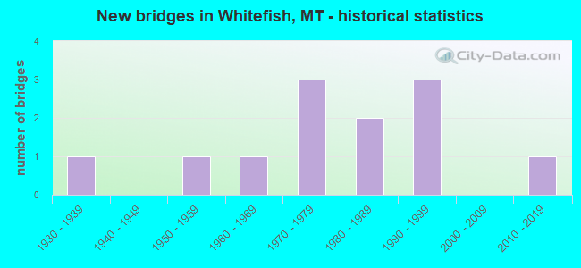
- New bridges - historical statistics
- 11930-1939
- 11950-1959
- 11960-1969
- 31970-1979
- 21980-1989
- 31990-1999
- 12010-2019


- Bridge Condition - Deck
- 45.5%Good
- 27.3%Satisfactory
- 27.3%Fair

- Bridge Condition - Superstructure
- 9.1%Very good
- 54.5%Good
- 9.1%Satisfactory
- 27.3%Fair

- Bridge Condition - Substructure
- 45.5%Good
- 18.2%Satisfactory
- 36.4%Fair

- Bridge Condition - Channel
- 10.0%Excellent
- 30.0%Very good
- 50.0%Good
- 10.0%Satisfactory
Find on map >> Show street view
Structure Number: L15200005+00001, Location: 2M E WHITEFISH (Lat: 48.414328, Lng: -114.284247), Route carried "on" structure: County highway 15200, Year Built: 1994, Status: Open, Structure Length: 1.52m (4.99ft), Average Daily Traffic: 1,110 (year 2020), Truck Traffic: 3%, Average Future Daily Traffic: 1,166 (year 2040), Design Load: HS 20, Features Intersected: HASKILL CREEK 071, Facility Carried by Structure: E EDGEWOOD DR
Minimum Vertical Clearance: 30+ m (98+ ft), Kilometerpoint: 7.875, Lanes on structure: 2, Owner: County Highway Agency, Approaching Roadway Width: 8.5m (27.9ft), Material/Design: Prestressed concrete, Design/Construction: Tee Beam, Number Of Spans In Main Unit: 1, Length of Maximum Span: 14.9m (48.9ft), Curb-To-Curb Width: 8.5m (27.9ft), Out-to-Out Width: 8.5m (27.9ft)
Condition: Deck: Fair, Superstructure: Fair, Substructure: Good, Channel: Excellent, Operating Rating: 34.5 metric tons, Method Used To Determine Operating Rating: Load and Resistance Factor (LRFR), Inventory Rating: 24.5 metric tons, Method Used To Determine Inventory Rating: Load and Resistance Factor (LRFR), Structural Evaluation: Somewhat better than minimum adequacy, Deck Geometry: Somewhat better than minimum adequacy, Waterway Adequacy: Equal to present desirable criteria, Approach Roadway Alignment: Equal to present desirable criteria, Designated Inspection Frequency: Every 24 months, Inspection Date: November 2021, Deck Structure Type: Concrete Precast Panels
Find on map >> Show street view
Structure Number: L15205000+03001, Location: 2M SE WHITEFISH (Lat: 48.385492, Lng: -114.329675), Route carried "on" structure: County highway 15205, Year Built: 1985, Status: Open, Structure Length: 3.96m (12.99ft), Average Daily Traffic: 3,014 (year 2020), Average Future Daily Traffic: 3,165 (year 2040), Design Load: HS 20, Features Intersected: WHITEFISH RIVER 154, Facility Carried by Structure: JP RD
Minimum Vertical Clearance: 30+ m (98+ ft), Kilometerpoint: 0.464, Lanes on structure: 2, Owner: County Highway Agency, Approaching Roadway Width: 6.7m (22.0ft), Skew: 2 degrees, Material/Design: Prestressed concrete, Design/Construction: Tee Beam, Number Of Spans In Main Unit: 1, Length of Maximum Span: 39.6m (129.9ft), Curb-To-Curb Width: 8.5m (27.9ft), Out-to-Out Width: 9.1m (29.9ft)
Condition: Deck: Fair, Superstructure: Fair, Substructure: Fair, Channel: Very good, Operating Rating: 28.1 metric tons, Method Used To Determine Operating Rating: Load and Resistance Factor (LRFR), Inventory Rating: 21.8 metric tons, Method Used To Determine Inventory Rating: Load and Resistance Factor (LRFR), Structural Evaluation: Somewhat better than minimum adequacy, Deck Geometry: Meets minimum limits, Waterway Adequacy: Equal to present desirable criteria, Approach Roadway Alignment: Equal to present desirable criteria, Designated Inspection Frequency: Every 24 months, Inspection Date: November 2021, Deck Structure Type: Concrete Precast Panels
Find on map >> Show street view
Structure Number: L15293000+07001, Location: 7M NW WHITEFISH (Lat: 48.485125, Lng: -114.433714), Route carried "on" structure: County highway 15293, Year Built: 1935, Status: Open, Structure Length: 1.85m (6.07ft), Average Daily Traffic: 100 (year 2022), Truck Traffic: 3%, Average Future Daily Traffic: 100 (year 2037), Features Intersected: SWIFT CREEK 072, Facility Carried by Structure: DELREY RD
Minimum Vertical Clearance: 30+ m (98+ ft), Kilometerpoint: 1.150, Lanes on structure: 1, Owner: County Highway Agency, Approaching Roadway Width: 5.5m (18.0ft), Material/Design: Steel, Design/Construction: Truss - Thru, Number Of Spans In Main Unit: 1, Length of Maximum Span: 18.3m (60.0ft), Curb-To-Curb Width: 3.8m (12.5ft), Out-to-Out Width: 4.0m (13.1ft)
Condition: Deck: Good, Superstructure: Satisfactory, Substructure: Fair, Channel: Good, Operating Rating: 39.9 metric tons, Method Used To Determine Operating Rating: Load Factor (LF), Inventory Rating: 23.6 metric tons, Method Used To Determine Inventory Rating: Load Factor (LF), Structural Evaluation: Somewhat better than minimum adequacy, Deck Geometry: Meets minimum limits, Waterway Adequacy: Equal to present desirable criteria, Approach Roadway Alignment: Equal to present minimum criteria, Designated Inspection Frequency: Every 24 months, Critical Feature Inspection Frequency: Every 24 months, Inspection Date: November 2021, Critical Feature Inspection Date: November 2021, Deck Structure Type: Wood or Timber, Wearing Surface/Protective System: Wearing Surface: Wood or Timber
Find on map >> Show street view
Structure Number: L15293001+05001, Location: 8M NW WHITEFISH (Lat: 48.474942, Lng: -114.433036), Route carried "on" structure: County highway 15293, Year Built: 1995, Status: Open, Structure Length: 0.91m (2.99ft), Average Daily Traffic: 100 (year 2022), Truck Traffic: 3%, Average Future Daily Traffic: 100 (year 2037), Design Load: HS 20, Features Intersected: LAZY CREEK 124, Facility Carried by Structure: DELREY RD
Minimum Vertical Clearance: 30+ m (98+ ft), Kilometerpoint: 2.295, Lanes on structure: 2, Owner: County Highway Agency, Approaching Roadway Width: 6.7m (22.0ft), Material/Design: Prestressed concrete, Design/Construction: Slab, Number Of Spans In Main Unit: 1, Length of Maximum Span: 9.1m (29.9ft), Curb-To-Curb Width: 7.3m (24.0ft), Out-to-Out Width: 8.6m (28.2ft)
Condition: Deck: Good, Superstructure: Good, Substructure: Fair, Channel: Very good, Operating Rating: 55.9 metric tons, Method Used To Determine Operating Rating: Load Factor (LF), Inventory Rating: 33.5 metric tons, Method Used To Determine Inventory Rating: Load Factor (LF), Structural Evaluation: Somewhat better than minimum adequacy, Deck Geometry: Equal to present minimum criteria, Waterway Adequacy: Equal to present desirable criteria, Approach Roadway Alignment: Equal to present desirable criteria, Designated Inspection Frequency: Every 24 months, Inspection Date: November 2021, Wearing Surface/Protective System: Wearing Surface: Monolithic Concrete
Find on map >> Show street view
Structure Number: M15120000+00101, Location: WHITEFISH-BAKER AVE (Lat: 48.406597, Lng: -114.338189), Route carried "on" structure: City street 12002, Year Built: 1977, Status: Open, Structure Length: 3.29m (10.79ft), Average Daily Traffic: 8,770 (year 2020), Average Future Daily Traffic: 9,209 (year 2040), Design Load: HS 20, Features Intersected: WHITEFISH RIVER 113, Facility Carried by Structure: BAKER AVE
Minimum Vertical Clearance: 30+ m (98+ ft), Kilometerpoint: 0.449, Lanes on structure: 2, Owner: City or Municipal Highway Agency, Approaching Roadway Width: 11.0m (36.1ft), Material/Design: Prestressed concrete, Design/Construction: Stringer/Multi-beam, Number Of Spans In Main Unit: 1, Length of Maximum Span: 32.0m (105.0ft), Curb or Sidewalk Widths: Left: 1.5m (4.9ft), Right: 1.5m (4.9ft), Curb-To-Curb Width: 8.8m (28.9ft), Out-to-Out Width: 11.1m (36.4ft)
Condition: Deck: Satisfactory, Superstructure: Very good, Substructure: Fair, Channel: Good, Operating Rating: 32.7 metric tons, Method Used To Determine Operating Rating: Assigned rating based on Load Factor Design (LFD) reported in metric tons, Inventory Rating: 32.7 metric tons, Method Used To Determine Inventory Rating: Assigned rating based on Load Factor Design (LFD) reported in metric tons, Structural Evaluation: Somewhat better than minimum adequacy, Deck Geometry: High priority of replacement, Waterway Adequacy: Equal to present desirable criteria, Approach Roadway Alignment: Equal to present desirable criteria, Designated Inspection Frequency: Every 24 months, Inspection Date: November 2021, Deck Structure Type: Concrete Cast-file-Place, Wearing Surface/Protective System: Wearing Surface: Monolithic Concrete
Find on map >> Show street view
Structure Number: M15120000+00201, Location: WHITEFISH-COLUMBIA AVE (Lat: 48.400747, Lng: -114.332494), Route carried "on" structure: City street 15120, Year Built: 1979, Status: Open, Structure Length: 5.55m (18.21ft), Average Daily Traffic: 3,258 (year 2020), Truck Traffic: 3%, Average Future Daily Traffic: 3,421 (year 2040), Design Load: HS 20, Features Intersected: WHITEFISH RIVER 109, Facility Carried by Structure: COLUMBIA AVE
Minimum Vertical Clearance: 30+ m (98+ ft), Kilometerpoint: 0.288, Lanes on structure: 2, Owner: City or Municipal Highway Agency, Approaching Roadway Width: 11.0m (36.1ft), Material/Design: Prestressed concrete, Design/Construction: Stringer/Multi-beam, Number Of Spans In Main Unit: 2, Length of Maximum Span: 29.0m (95.1ft), Curb or Sidewalk Widths: Left: 0.0m, Right: 1.3m (4.3ft), Curb-To-Curb Width: 8.7m (28.5ft), Out-to-Out Width: 11.1m (36.4ft)
Condition: Deck: Fair, Superstructure: Good, Substructure: Satisfactory, Channel: Good, Operating Rating: 55.3 metric tons, Method Used To Determine Operating Rating: Load and Resistance Factor (LRFR), Inventory Rating: 40.8 metric tons, Method Used To Determine Inventory Rating: Load and Resistance Factor (LRFR), Structural Evaluation: Equal to present minimum criteria, Deck Geometry: Meets minimum limits, Waterway Adequacy: Equal to present desirable criteria, Approach Roadway Alignment: Equal to present desirable criteria, Designated Inspection Frequency: Every 24 months, Inspection Date: September 2020, Deck Structure Type: Concrete Cast-file-Place, Wearing Surface/Protective System: Wearing Surface: Monolithic Concrete
Find on map >> Show street view
Structure Number: P00005000+00001, Location: 5M NW MISSOULA (Lat: 46.951381, Lng: -114.131231), Route carried "on" structure: US 93, Year Built: 1966, Year Reconstructed: 1995, Status: Open, Structure Length: 10.55m (34.61ft), Average Daily Traffic: 10,400 (year 2020), Truck Traffic: 4%, Average Future Daily Traffic: 10,920 (year 2040), Design Load: HS 20, Features Intersected: INT DESMET I 90
Minimum Vertical Clearance: 30+ m (98+ ft), Kilometerpoint: 0.021, Lanes on structure: 2, Lanes under structure: 3, Base Highway Network: Yes, Owner: State Highway Agency, Approaching Roadway Width: 8.5m (27.9ft), Skew: 23 degrees, Material/Design: Prestressed concrete, Design/Construction: Stringer/Multi-beam, Number Of Spans In Main Unit: 4, Length of Maximum Span: 29.3m (96.1ft), Curb-To-Curb Width: 8.5m (27.9ft), Out-to-Out Width: 8.8m (28.9ft)
Condition: Deck: Good, Superstructure: Fair, Substructure: Satisfactory, Operating Rating: 40.8 metric tons, Method Used To Determine Operating Rating: Load and Resistance Factor (LRFR), Inventory Rating: 26.3 metric tons, Method Used To Determine Inventory Rating: Load and Resistance Factor (LRFR), Structural Evaluation: Somewhat better than minimum adequacy, Deck Geometry: High priority of corrective action, Underclear: Equal to present minimum criteria, Approach Roadway Alignment: Equal to present desirable criteria, Designated Inspection Frequency: Every 24 months, Inspection Date: June 2020, Deck Structure Type: Concrete Cast-file-Place, Wearing Surface/Protective System: Wearing Surface: Latex Concrete, Deck Protection: Epoxy Coated Reinforcing
Find on map >> Show street view
Structure Number: P00005127+01001, Location: WHITEFISH-SPOKANE AVE (Lat: 48.401647, Lng: -114.335211), Route carried "on" structure: US 93, Year Built: 1959, Status: Open, Structure Length: 1.83m (6.00ft), Average Daily Traffic: 13,489 (year 2020), Truck Traffic: 2%, Average Future Daily Traffic: 14,163 (year 2040), Features Intersected: WHITEFISH RIVER, Facility Carried by Structure: SPOKANE AVE
Minimum Vertical Clearance: 30+ m (98+ ft), Kilometerpoint: 203.117, Lanes on structure: 2, Base Highway Network: Yes, Owner: State Highway Agency, Approaching Roadway Width: 11.0m (36.1ft), Material/Design: Steel, Design/Construction: Culvert, Number Of Spans In Main Unit: 3, Length of Maximum Span: 4.6m (15.1ft)
Condition: Channel: Good, Culverts: Good, Operating Rating: 89.8 metric tons, Method Used To Determine Operating Rating: Field evaluation and documented engineering judgment, Inventory Rating: 89.8 metric tons, Method Used To Determine Inventory Rating: Field evaluation and documented engineering judgment, Structural Evaluation: Better than present minimum criteria, Waterway Adequacy: Equal to present desirable criteria, Approach Roadway Alignment: Equal to present desirable criteria, Designated Inspection Frequency: Every 24 months, Inspection Date: November 2021
Find on map >> Show street view
Structure Number: P00005128+00531, Location: WHITEFISH-SECOND ST (Lat: 48.410594, Lng: -114.342692), Route carried "on" structure: US 93, Year Built: 2013, Status: Open, Structure Length: 4.30m (14.11ft), Average Daily Traffic: 8,353 (year 2020), Truck Traffic: 3%, Average Future Daily Traffic: 8,771 (year 2040), Design Load: HL 93, Features Intersected: WHITEFISH RIVER, Facility Carried by Structure: SECOND ST
Minimum Vertical Clearance: 30+ m (98+ ft), Kilometerpoint: 204.667, Lanes on structure: 2, Base Highway Network: Yes, Owner: State Highway Agency, Approaching Roadway Width: 8.4m (27.6ft), Skew: 1 degrees, Material/Design: Steel, Design/Construction: Stringer/Multi-beam, Number Of Spans In Main Unit: 1, Length of Maximum Span: 42.0m (137.8ft), Curb or Sidewalk Widths: Left: 3.1m (10.2ft), Right: 2.5m (8.2ft), Curb-To-Curb Width: 8.4m (27.6ft), Out-to-Out Width: 14.8m (48.6ft)
Condition: Deck: Satisfactory, Superstructure: Good, Substructure: Good, Channel: Very good, Operating Rating: 29.9 metric tons, Method Used To Determine Operating Rating: Load and Resistance Factor (LRFR), Inventory Rating: 22.7 metric tons, Method Used To Determine Inventory Rating: Load and Resistance Factor (LRFR), Structural Evaluation: Somewhat better than minimum adequacy, Deck Geometry: High priority of replacement, Waterway Adequacy: Equal to present desirable criteria, Approach Roadway Alignment: Equal to present desirable criteria, Designated Inspection Frequency: Every 24 months, Inspection Date: August 2020, Deck Structure Type: Concrete Cast-file-Place, Wearing Surface/Protective System: Wearing Surface: Monolithic Concrete, Deck Protection: Epoxy Coated Reinforcing
Find on map >> Show street view
Structure Number: P00038001+06861, Location: 3M SE WHITEFISH (Lat: 48.370692, Lng: -114.302197), Route carried "on" structure: State highway 40, Year Built: 1975, Status: Open, Structure Length: 4.36m (14.30ft), Average Daily Traffic: 11,295 (year 2020), Truck Traffic: 2%, Average Future Daily Traffic: 12,425 (year 2040), Design Load: HS 20, Features Intersected: WHITEFISH RIVER
Minimum Vertical Clearance: 30+ m (98+ ft), Kilometerpoint: 2.698, Lanes on structure: 2, Base Highway Network: Yes, Owner: State Highway Agency, Approaching Roadway Width: 13.4m (44.0ft), Material/Design: Prestressed concrete, Design/Construction: Stringer/Multi-beam, Number Of Spans In Main Unit: 2, Length of Maximum Span: 21.6m (70.9ft), Curb-To-Curb Width: 14.5m (47.6ft), Out-to-Out Width: 15.3m (50.2ft)
Condition: Deck: Good, Superstructure: Good, Substructure: Good, Channel: Good, Operating Rating: 42.6 metric tons, Method Used To Determine Operating Rating: Load and Resistance Factor (LRFR), Inventory Rating: 24.5 metric tons, Method Used To Determine Inventory Rating: Load and Resistance Factor (LRFR), Structural Evaluation: Equal to present minimum criteria, Deck Geometry: Superior to present desirable criteria, Waterway Adequacy: Equal to present desirable criteria, Approach Roadway Alignment: Equal to present desirable criteria, Designated Inspection Frequency: Every 24 months, Underwater Inspection Frequency: Every 60 months, Inspection Date: September 2020, Underwater Inspection Date: September 2019, Deck Structure Type: Concrete Cast-file-Place, Wearing Surface/Protective System: Wearing Surface: Latex Concrete
Find on map >> Show street view
Structure Number: S00424015+08491, Location: 5M SW WHITEFISH (Lat: 48.386489, Lng: -114.432511), Route carried "on" structure: State highway 424, Year Built: 1988, Status: Open, Structure Length: 10.75m (35.27ft), Average Daily Traffic: 1,814 (year 2020), Truck Traffic: 3%, Average Future Daily Traffic: 2,032 (year 2040), Design Load: HS 20, Features Intersected: STILLWATER RIVER, Facility Carried by Structure: TWIN BRIDGES RD
Minimum Vertical Clearance: 30+ m (98+ ft), Kilometerpoint: 26.283, Lanes on structure: 2, Owner: State Highway Agency, Approaching Roadway Width: 8.5m (27.9ft), Material/Design: Steel continuous, Design/Construction: Stringer/Multi-beam, Number Of Spans In Main Unit: 4, Length of Maximum Span: 29.6m (97.1ft), Curb-To-Curb Width: 8.3m (27.2ft), Out-to-Out Width: 9.2m (30.2ft)
Condition: Deck: Satisfactory, Superstructure: Good, Substructure: Good, Channel: Satisfactory, Operating Rating: 25.4 metric tons, Method Used To Determine Operating Rating: Load and Resistance Factor (LRFR), Inventory Rating: 22.7 metric tons, Method Used To Determine Inventory Rating: Load and Resistance Factor (LRFR), Structural Evaluation: Equal to present minimum criteria, Deck Geometry: Meets minimum limits, Waterway Adequacy: Equal to present desirable criteria, Approach Roadway Alignment: Equal to present minimum criteria, Length Of Structure Improvement: 11.60m (38.06ft), Designated Inspection Frequency: Every 24 months, Inspection Date: August 2020, Bridge Improvement Cost: $632,000, Roadway Improvement Cost: $316,000, Total Project Cost: $948,000, Deck Structure Type: Concrete Cast-file-Place, Wearing Surface/Protective System: Wearing Surface: Monolithic Concrete, Deck Protection: Epoxy Coated Reinforcing
Find on map >> Show street view
Structure Number: S00487000+02001, Location: WHITEFISH-BAKER AVE (Lat: 48.414164, Lng: -114.338881), Route carried "on" structure: City street 12001, Year Built: 1994, Status: Open, Structure Length: 12.55m (41.17ft), Average Daily Traffic: 15,046 (year 2020), Average Future Daily Traffic: 15,798 (year 2040), Design Load: HS 20, Features Intersected: RR, Facility Carried by Structure: BAKER AVE
Minimum Vertical Clearance: 30+ m (98+ ft), Kilometerpoint: 0.406, Lanes on structure: 2, Owner: State Highway Agency, Approaching Roadway Width: 13.4m (44.0ft), Skew: 1 degrees, Material/Design: Steel continuous, Design/Construction: Stringer/Multi-beam, Number Of Spans In Main Unit: 5, Length of Maximum Span: 34.4m (112.9ft), Curb or Sidewalk Widths: Left: 2.4m (7.9ft), Right: 2.4m (7.9ft), Curb-To-Curb Width: 13.4m (44.0ft), Out-to-Out Width: 19.2m (63.0ft)
Condition: Deck: Good, Superstructure: Good, Substructure: Good, Operating Rating: 58.1 metric tons, Method Used To Determine Operating Rating: Load Factor (LF), Inventory Rating: 32.7 metric tons, Method Used To Determine Inventory Rating: Load Factor (LF), Structural Evaluation: Better than present minimum criteria, Deck Geometry: Equal to present minimum criteria, Underclear: Somewhat better than minimum adequacy, Approach Roadway Alignment: Equal to present desirable criteria, Designated Inspection Frequency: Every 24 months, Inspection Date: August 2020, Deck Structure Type: Concrete Cast-file-Place, Wearing Surface/Protective System: Wearing Surface: Monolithic Concrete, Deck Protection: Epoxy Coated Reinforcing