Bridge Statistics for Wiggins, Colorado (CO)
Condition, Traffic, Stress, Structural Evaluation, Project Costs
- National Bridge Inventory (NBI) Statistics
- 25Number of bridges
- 492ft / 150mTotal length
- $2,461,000Total costs
- 153,818Total average daily traffic
- 28,022Total average daily truck traffic
- National Bridge Inventory (NBI) Registered Bridges for Wiggins
- No street view available for this location
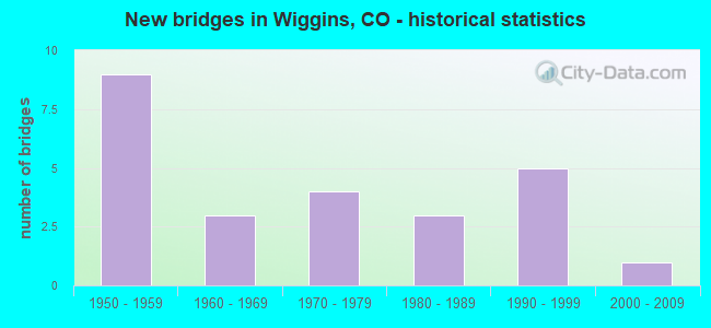
- New bridges - historical statistics
- 91950-1959
- 31960-1969
- 41970-1979
- 31980-1989
- 51990-1999
- 12000-2009

- Reconstructed bridges - Historical Statistics
- 21970-1979
- 11980-1989
- 01990-1999
- 12000-2009


- Bridge Condition - Deck
- 47.1%Good
- 41.2%Satisfactory
- 11.8%Fair

- Bridge Condition - Superstructure
- 35.3%Good
- 47.1%Satisfactory
- 17.6%Fair

- Bridge Condition - Substructure
- 35.3%Good
- 41.2%Satisfactory
- 17.6%Fair
- 5.9%Poor

- Bridge Condition - Channel
- 69.2%Very good
- 23.1%Good
- 7.7%Satisfactory
Find on map >> Show street view
Structure Number: D-20-AC, Location: AT JCT OF I-76 (Lat: 40.232186, Lng: -104.093522), Route carried "on" structure: US 6I, Year Built: 1959, Status: Open, Structure Length: 6.90m (22.64ft), Average Daily Traffic: 1,300 (year 2020), Truck Traffic: 9%, Average Future Daily Traffic: 1,560 (year 2040), Design Load: HS 20, Features Intersected: I 76 ML, Facility Carried by Structure: US 6 ML
Minimum Vertical Clearance: 30+ m (98+ ft), Kilometerpoint: 25.718, Lanes on structure: 2, Lanes under structure: 4, Owner: State Highway Agency, Approaching Roadway Width: 9.8m (32.2ft), Material/Design: Concrete continuous, Design/Construction: Tee Beam, Number Of Spans In Main Unit: 4, Length of Maximum Span: 20.0m (65.6ft), Curb-To-Curb Width: 8.5m (27.9ft), Out-to-Out Width: 9.8m (32.2ft)
Condition: Deck: Satisfactory, Superstructure: Satisfactory, Substructure: Satisfactory, Operating Rating: 65.6 metric tons, Method Used To Determine Operating Rating: Load Factor (LF), Inventory Rating: 39.3 metric tons, Method Used To Determine Inventory Rating: Load Factor (LF), Structural Evaluation: Equal to present minimum criteria, Deck Geometry: Somewhat better than minimum adequacy, Underclear: Meets minimum limits, Approach Roadway Alignment: Equal to present desirable criteria, Length Of Structure Improvement: 6.92m (22.70ft), Designated Inspection Frequency: Every 24 months, Inspection Date: March 2021, Bridge Improvement Cost: $262,000, Roadway Improvement Cost: $26,000, Total Project Cost: $392,000, Deck Structure Type: Concrete Cast-file-Place, Wearing Surface/Protective System: Wearing Surface: Bituminous
Find on map >> Show street view
Structure Number: D-20-AG, Location: NEAR WIGGINS (Lat: 40.238231, Lng: -104.074625), Route carried "on" structure: County highway , Year Built: 1959, Status: Open, Structure Length: 8.08m (26.51ft), Average Daily Traffic: 14,000 (year 2018), Truck Traffic: 10%, Average Future Daily Traffic: 606 (year 2028), Design Load: HS 20, Features Intersected: I 76 ML, Facility Carried by Structure: COUNTY ROAD 4
Minimum Vertical Clearance: 30+ m (98+ ft), Kilometerpoint: 0.021, Lanes on structure: 2, Lanes under structure: 4, Owner: State Highway Agency, Approaching Roadway Width: 11.0m (36.1ft), Skew: 3 degrees, Material/Design: Concrete continuous, Design/Construction: Tee Beam, Number Of Spans In Main Unit: 4, Length of Maximum Span: 23.2m (76.1ft), Curb-To-Curb Width: 7.3m (24.0ft), Out-to-Out Width: 8.5m (27.9ft)
Condition: Deck: Fair, Superstructure: Satisfactory, Substructure: Satisfactory, Operating Rating: 67.6 metric tons, Method Used To Determine Operating Rating: Load Factor (LF), Inventory Rating: 40.5 metric tons, Method Used To Determine Inventory Rating: Load Factor (LF), Structural Evaluation: Equal to present minimum criteria, Deck Geometry: High priority of replacement, Underclear: Equal to present minimum criteria, Approach Roadway Alignment: Equal to present desirable criteria, Designated Inspection Frequency: Every 24 months, Inspection Date: March 2021, Deck Structure Type: Concrete Cast-file-Place, Wearing Surface/Protective System: Wearing Surface: Bituminous
Find on map >> Show street view
Structure Number: D-20-AH, Location: 0.2 MI NO OF JCT SH 6 (Lat: 40.245672, Lng: -104.055722), Route carried "on" structure: State highway 39A, Year Built: 1959, Status: Open, Structure Length: 7.06m (23.16ft), Average Daily Traffic: 2,300 (year 2020), Truck Traffic: 15%, Average Future Daily Traffic: 3,358 (year 2040), Design Load: HS 20, Features Intersected: I 76 ML, Facility Carried by Structure: SH 39 ML
Minimum Vertical Clearance: 30+ m (98+ ft), Kilometerpoint: 0.343, Lanes on structure: 2, Lanes under structure: 4, Base Highway Network: Yes, Owner: State Highway Agency, Approaching Roadway Width: 10.4m (34.1ft), Skew: 1 degrees, Material/Design: Concrete continuous, Design/Construction: Tee Beam, Number Of Spans In Main Unit: 4, Length of Maximum Span: 20.3m (66.6ft), Curb-To-Curb Width: 9.1m (29.9ft), Out-to-Out Width: 10.4m (34.1ft)
Condition: Deck: Satisfactory, Superstructure: Fair, Substructure: Fair, Operating Rating: 62.7 metric tons, Method Used To Determine Operating Rating: Load Factor (LF), Inventory Rating: 37.6 metric tons, Method Used To Determine Inventory Rating: Load Factor (LF), Structural Evaluation: Somewhat better than minimum adequacy, Deck Geometry: Meets minimum limits, Underclear: Meets minimum limits, Approach Roadway Alignment: Equal to present desirable criteria, Length Of Structure Improvement: 7.06m (23.16ft), Designated Inspection Frequency: Every 24 months, Inspection Date: November 2021, Bridge Improvement Cost: $1,083,000, Roadway Improvement Cost: $108,000, Total Project Cost: $1,191,000 ( Estimate for 2019), Deck Structure Type: Other, Wearing Surface/Protective System: Wearing Surface: Bituminous
Find on map >> Show street view
Structure Number: D-20-AJ, Location: 2.5 MI E OF WIGGINS (Lat: 40.248458, Lng: -104.036950), Route carried "on" structure: ServiceInterstate 76A, Year Built: 1977, Status: Open, Structure Length: 13.76m (45.14ft), Average Daily Traffic: 19,000 (year 2020), Truck Traffic: 17%, Average Future Daily Traffic: 25,460 (year 2040), Design Load: HS 20+Mod, Features Intersected: BIJOU CREEK SR, Facility Carried by Structure: I 76 FRONTAGE ROAD
Minimum Vertical Clearance: 30+ m (98+ ft), Kilometerpoint: 1.622, Lanes on structure: 2, Base Highway Network: Yes, Owner: State Highway Agency, Approaching Roadway Width: 9.1m (29.9ft), Material/Design: Concrete continuous, Design/Construction: Tee Beam, Number Of Spans In Main Unit: 9, Length of Maximum Span: 15.2m (49.9ft), Curb-To-Curb Width: 10.4m (34.1ft), Out-to-Out Width: 11.1m (36.4ft)
Condition: Deck: Good, Superstructure: Good, Substructure: Good, Channel: Very good, Operating Rating: 65.9 metric tons, Method Used To Determine Operating Rating: Load Factor (LF), Inventory Rating: 39.4 metric tons, Method Used To Determine Inventory Rating: Load Factor (LF), Structural Evaluation: Better than present minimum criteria, Deck Geometry: Meets minimum limits, Waterway Adequacy: Equal to present desirable criteria, Approach Roadway Alignment: Equal to present desirable criteria, Designated Inspection Frequency: Every 24 months, Inspection Date: March 2021, Deck Structure Type: Concrete Cast-file-Place, Wearing Surface/Protective System: Wearing Surface: Bituminous, Membrane: Preformed Fabric
Find on map >> Show street view
Structure Number: D-20-AP, Location: 4.6 MI E OF JCT SH 144 (Lat: 40.247575, Lng: -104.056089), Route carried "on" structure: US 34A, Year Built: 1982, Status: Open, Structure Length: 5.33m (17.49ft), Average Daily Traffic: 4,500 (year 2020), Truck Traffic: 15%, Average Future Daily Traffic: 6,210 (year 2040), Design Load: HS 20+Mod, Features Intersected: SH 39 ML, Facility Carried by Structure: US 34 ML
Minimum Vertical Clearance: 30+ m (98+ ft), Kilometerpoint: 238.838, Lanes on structure: 2, Lanes under structure: 2, Base Highway Network: Yes, Owner: State Highway Agency, Approaching Roadway Width: 12.8m (42.0ft), Skew: 2 degrees, Material/Design: Steel continuous, Design/Construction: Stringer/Multi-beam, Number Of Spans In Main Unit: 3, Length of Maximum Span: 28.5m (93.5ft), Curb-To-Curb Width: 13.4m (44.0ft), Out-to-Out Width: 14.2m (46.6ft)
Condition: Deck: Satisfactory, Superstructure: Satisfactory, Substructure: Good, Operating Rating: 57.1 metric tons, Method Used To Determine Operating Rating: Load Factor (LF), Inventory Rating: 34.2 metric tons, Method Used To Determine Inventory Rating: Load Factor (LF), Structural Evaluation: Equal to present minimum criteria, Deck Geometry: Better than present minimum criteria, Underclear: Superior to present desirable criteria, Approach Roadway Alignment: Equal to present desirable criteria, Designated Inspection Frequency: Every 48 months, Inspection Date: December 2019, Deck Structure Type: Concrete Cast-file-Place, Wearing Surface/Protective System: Wearing Surface: Bituminous, Membrane: Preformed Fabric
Find on map >> Show street view
Structure Number: D-20-AR, Location: 1.8 MI SW OF JCT SH 39 (Lat: 40.233122, Lng: -104.089242), Route carried "on" structure: Interstate 76A, Year Built: 1993, Status: Open, Structure Length: 11.84m (38.85ft), Average Daily Traffic: 6,500 (year 2020), Truck Traffic: 19%, Average Future Daily Traffic: 9,165 (year 2040), Design Load: HS 20, Features Intersected: KIOWA CREEK, Facility Carried by Structure: I 76 ML WBND
Minimum Vertical Clearance: 30+ m (98+ ft), Kilometerpoint: 103.090, Lanes on structure: 2, Base Highway Network: Yes, Owner: State Highway Agency, Approaching Roadway Width: 11.6m (38.1ft), Skew: 11 degrees, Material/Design: Prestressed concrete, Design/Construction: Box Beam or Girders - Single/Spread, Number Of Spans In Main Unit: 5, Length of Maximum Span: 23.7m (77.8ft), Curb-To-Curb Width: 11.6m (38.1ft), Out-to-Out Width: 12.3m (40.4ft)
Condition: Deck: Good, Superstructure: Good, Substructure: Good, Channel: Very good, Operating Rating: 72.4 metric tons, Method Used To Determine Operating Rating: Load Factor (LF), Inventory Rating: 29.0 metric tons, Method Used To Determine Inventory Rating: Load Factor (LF), Structural Evaluation: Better than present minimum criteria, Deck Geometry: Equal to present minimum criteria, Waterway Adequacy: Equal to present desirable criteria, Approach Roadway Alignment: Equal to present desirable criteria, Designated Inspection Frequency: Every 24 months, Inspection Date: March 2021, Deck Structure Type: Concrete Cast-file-Place, Wearing Surface/Protective System: Wearing Surface: Bituminous, Membrane: Preformed Fabric, Deck Protection: Epoxy Coated Reinforcing
Find on map >> Show street view
Structure Number: D-20-AS, Location: 0.3 MI NE OF JCT US 6 (Lat: 40.232872, Lng: -104.089219), Route carried "on" structure: Interstate 76A, Year Built: 1993, Status: Open, Structure Length: 11.84m (38.85ft), Average Daily Traffic: 6,500 (year 2020), Truck Traffic: 19%, Average Future Daily Traffic: 9,165 (year 2040), Design Load: HS 20, Features Intersected: KIOWA CREEK, Facility Carried by Structure: I 76 ML EBND
Minimum Vertical Clearance: 30+ m (98+ ft), Kilometerpoint: 103.085, Lanes on structure: 2, Base Highway Network: Yes, Owner: State Highway Agency, Approaching Roadway Width: 11.6m (38.1ft), Skew: 11 degrees, Material/Design: Prestressed concrete, Design/Construction: Box Beam or Girders - Single/Spread, Number Of Spans In Main Unit: 5, Length of Maximum Span: 23.8m (78.1ft), Curb-To-Curb Width: 11.6m (38.1ft), Out-to-Out Width: 12.3m (40.4ft)
Condition: Deck: Good, Superstructure: Good, Substructure: Good, Channel: Very good, Operating Rating: 72.4 metric tons, Method Used To Determine Operating Rating: Load Factor (LF), Inventory Rating: 29.0 metric tons, Method Used To Determine Inventory Rating: Load Factor (LF), Structural Evaluation: Better than present minimum criteria, Deck Geometry: Equal to present minimum criteria, Waterway Adequacy: Equal to present desirable criteria, Approach Roadway Alignment: Equal to present desirable criteria, Designated Inspection Frequency: Every 24 months, Inspection Date: March 2021, Deck Structure Type: Concrete Cast-file-Place, Wearing Surface/Protective System: Wearing Surface: Bituminous, Membrane: Preformed Fabric, Deck Protection: Epoxy Coated Reinforcing
Find on map >> Show street view
Structure Number: D-20-AT, Location: 4.6 MI E OF JCT SH 144 (Lat: 40.246622, Lng: -104.053550), Route carried "on" structure: Ramp US 34A, Year Built: 1993, Status: Open, Structure Length: 13.97m (45.83ft), Average Daily Traffic: 11,000 (year 2018), Truck Traffic: 18%, Average Future Daily Traffic: 4,191 (year 2025), Design Load: HS 20, Features Intersected: I 76 ML R, Facility Carried by Structure: RAMP TO I 76 EBND
Minimum Vertical Clearance: 30+ m (98+ ft), Kilometerpoint: 239.077, Lanes on structure: 1, Lanes under structure: 5, Base Highway Network: Yes, Owner: State Highway Agency, Approaching Roadway Width: 8.5m (27.9ft), Skew: 5 degrees, Material/Design: Steel continuous, Design/Construction: Stringer/Multi-beam, Number Of Spans In Main Unit: 4, Length of Maximum Span: 48.8m (160.1ft), Curb-To-Curb Width: 8.5m (27.9ft), Out-to-Out Width: 9.3m (30.5ft)
Condition: Deck: Good, Superstructure: Good, Substructure: Good, Operating Rating: 9.0 metric tons, Method Used To Determine Operating Rating: Load Factor (LF), Inventory Rating: 6.9 metric tons, Method Used To Determine Inventory Rating: Load Factor (LF), Structural Evaluation: High priority of corrective action, Deck Geometry: Superior to present desirable criteria, Underclear: Somewhat better than minimum adequacy, Approach Roadway Alignment: Equal to present desirable criteria, Designated Inspection Frequency: Every 24 months, Inspection Date: March 2021, Deck Structure Type: Concrete Cast-file-Place, Wearing Surface/Protective System: Wearing Surface: Bituminous, Membrane: Built-up, Deck Protection: Epoxy Coated Reinforcing
Find on map >> Show street view
Structure Number: D-20-B, Location: 1 MI E OF WIGGINS (Lat: 40.248247, Lng: -104.036906), Route carried "on" structure: Interstate 76A, Year Built: 1955, Year Reconstructed: 1978, Status: Open, Structure Length: 13.76m (45.14ft), Average Daily Traffic: 9,500 (year 2020), Truck Traffic: 17%, Average Future Daily Traffic: 12,730 (year 2040), Design Load: HS 20+Mod, Features Intersected: BIJOU CREEK, Facility Carried by Structure: I 76 ML WBND
Minimum Vertical Clearance: 30+ m (98+ ft), Kilometerpoint: 107.918, Lanes on structure: 2, Base Highway Network: Yes, Owner: State Highway Agency, Approaching Roadway Width: 11.6m (38.1ft), Skew: 10 degrees, Material/Design: Concrete, Design/Construction: Tee Beam, Number Of Spans In Main Unit: 9, Length of Maximum Span: 15.2m (49.9ft), Curb-To-Curb Width: 11.9m (39.0ft), Out-to-Out Width: 12.9m (42.3ft)
Condition: Deck: Good, Superstructure: Satisfactory, Substructure: Satisfactory, Channel: Good, Operating Rating: 56.7 metric tons, Method Used To Determine Operating Rating: Load Factor (LF), Inventory Rating: 33.9 metric tons, Method Used To Determine Inventory Rating: Load Factor (LF), Structural Evaluation: Equal to present minimum criteria, Deck Geometry: Equal to present minimum criteria, Waterway Adequacy: Superior to present desirable criteria, Approach Roadway Alignment: Equal to present desirable criteria, Designated Inspection Frequency: Every 24 months, Inspection Date: March 2021, Deck Structure Type: Concrete Cast-file-Place, Wearing Surface/Protective System: Wearing Surface: Bituminous, Membrane: Built-up
Find on map >> Show street view
Structure Number: D-20-C, Location: 1 MI EAST OF JCT US 34 (Lat: 40.247858, Lng: -104.036875), Route carried "on" structure: Interstate 76A, Year Built: 1966, Year Reconstructed: 1978, Status: Open, Structure Length: 13.64m (44.75ft), Average Daily Traffic: 9,500 (year 2020), Truck Traffic: 17%, Average Future Daily Traffic: 12,730 (year 2040), Design Load: HS 20+Mod, Features Intersected: BIJOU CREEK, Facility Carried by Structure: I 76 ML EBND
Minimum Vertical Clearance: 30+ m (98+ ft), Kilometerpoint: 107.913, Lanes on structure: 2, Base Highway Network: Yes, Owner: State Highway Agency, Approaching Roadway Width: 11.6m (38.1ft), Skew: 10 degrees, Material/Design: Steel, Design/Construction: Stringer/Multi-beam, Number Of Spans In Main Unit: 9, Length of Maximum Span: 15.1m (49.5ft), Curb-To-Curb Width: 11.9m (39.0ft), Out-to-Out Width: 12.9m (42.3ft)
Condition: Deck: Satisfactory, Superstructure: Fair, Substructure: Fair, Channel: Very good, Operating Rating: 68.8 metric tons, Method Used To Determine Operating Rating: Load Factor (LF), Inventory Rating: 41.2 metric tons, Method Used To Determine Inventory Rating: Load Factor (LF), Structural Evaluation: Somewhat better than minimum adequacy, Deck Geometry: Equal to present minimum criteria, Waterway Adequacy: Equal to present desirable criteria, Approach Roadway Alignment: Equal to present desirable criteria, Designated Inspection Frequency: Every 24 months, Inspection Date: March 2021, Deck Structure Type: Concrete Cast-file-Place, Wearing Surface/Protective System: Wearing Surface: Bituminous, Membrane: Preformed Fabric
Find on map >> Show street view
Structure Number: D-20-G_MINOR, Location: 3 MI SW OF WIGGINS (Lat: 40.231978, Lng: -104.131403), Route carried "on" structure: Interstate 76A, Year Built: 1958, Year Reconstructed: 1992, Status: Open, Structure Length: 0.61m (2.00ft), Average Daily Traffic: 14,000 (year 2020), Truck Traffic: 19%, Average Future Daily Traffic: 19,740 (year 2040), Design Load: HS 20, Features Intersected: SH 144 ML, Facility Carried by Structure: I 76 ML
Minimum Vertical Clearance: 30+ m (98+ ft), Kilometerpoint: 99.488, Lanes on structure: 4, Lanes under structure: 1, Base Highway Network: Yes, Owner: State Highway Agency, Approaching Roadway Width: 23.2m (76.1ft), Skew: 20 degrees, Material/Design: Concrete, Design/Construction: Culvert, Number Of Spans In Main Unit: 1, Length of Maximum Span: 6.1m (20.0ft), Curb-To-Curb Width: 23.2m (76.1ft), Out-to-Out Width: 43.0m (141.1ft)
Condition: Culverts: Good, Operating Rating: 36.3 metric tons, Method Used To Determine Operating Rating: Field evaluation and documented engineering judgment, Inventory Rating: 32.7 metric tons, Method Used To Determine Inventory Rating: Field evaluation and documented engineering judgment, Structural Evaluation: Better than present minimum criteria, Deck Geometry: Superior to present desirable criteria, Underclear: High priority of corrective action, Approach Roadway Alignment: Equal to present desirable criteria, Designated Inspection Frequency: Every 24 months, Inspection Date: Febuary 2021
Find on map >> Show street view
Structure Number: D-20-K, Location: JUST WEST OF WIGGINS (Lat: 40.232614, Lng: -104.089144), Route carried "on" structure: US 6I, Year Built: 2005, Status: Open, Structure Length: 10.52m (34.51ft), Average Daily Traffic: 1,300 (year 2020), Truck Traffic: 9%, Average Future Daily Traffic: 1,560 (year 2040), Design Load: HL 93, Features Intersected: KIOWA CREEK, Facility Carried by Structure: US 6 ML
Minimum Vertical Clearance: 30+ m (98+ ft), Kilometerpoint: 0.639, Lanes on structure: 2, Base Highway Network: Yes, Owner: State Highway Agency, Approaching Roadway Width: 11.0m (36.1ft), Material/Design: Prestressed concrete continuous, Design/Construction: Stringer/Multi-beam, Number Of Spans In Main Unit: 4, Length of Maximum Span: 26.0m (85.3ft), Curb-To-Curb Width: 12.2m (40.0ft), Out-to-Out Width: 13.1m (43.0ft)
Condition: Deck: Good, Superstructure: Good, Substructure: Good, Channel: Very good, Operating Rating: 36.0 metric tons, Method Used To Determine Operating Rating: Load and Resistance Factor Rating (LRFR) rating reported by rating factor(RF) method using HL-93 loadings, Inventory Rating: 27.5 metric tons, Method Used To Determine Inventory Rating: Load and Resistance Factor Rating (LRFR) rating reported by rating factor(RF) method using HL-93 loadings, Structural Evaluation: Equal to present minimum criteria, Deck Geometry: Better than present minimum criteria, Waterway Adequacy: Equal to present desirable criteria, Approach Roadway Alignment: Equal to present desirable criteria, Designated Inspection Frequency: Every 24 months, Inspection Date: March 2021, Deck Structure Type: Concrete Precast Panels, Wearing Surface/Protective System: Wearing Surface: Bituminous, Membrane: Built-up, Deck Protection: Epoxy Coated Reinforcing
Find on map >> Show street view
Structure Number: D-20-O, Location: 3.4 MI E OF JCT SH 144 (Lat: 40.247175, Lng: -104.079053), Route carried "on" structure: US 34A, Year Built: 1999, Status: Open, Structure Length: 2.53m (8.30ft), Average Daily Traffic: 5,800 (year 2020), Truck Traffic: 17%, Average Future Daily Traffic: 8,236 (year 2040), Design Load: HS 20, Features Intersected: KIOWA CREEK, Facility Carried by Structure: US 34 ML
Minimum Vertical Clearance: 30+ m (98+ ft), Kilometerpoint: 236.849, Lanes on structure: 2, Base Highway Network: Yes, Owner: State Highway Agency, Approaching Roadway Width: 13.4m (44.0ft), Material/Design: Concrete, Design/Construction: Culvert, Number Of Spans In Main Unit: 4, Length of Maximum Span: 6.1m (20.0ft), Out-to-Out Width: 27.7m (90.9ft)
Condition: Channel: Very good, Culverts: Good, Operating Rating: 36.3 metric tons, Method Used To Determine Operating Rating: Field evaluation and documented engineering judgment, Inventory Rating: 32.7 metric tons, Method Used To Determine Inventory Rating: Field evaluation and documented engineering judgment, Structural Evaluation: Better than present minimum criteria, Waterway Adequacy: Equal to present desirable criteria, Approach Roadway Alignment: Equal to present desirable criteria, Designated Inspection Frequency: Every 24 months, Inspection Date: November 2021
Find on map >> Show street view
Structure Number: MG2-0.4-M.5, Location: 0.4 Mi N of Co Rd M.5 (Lat: 40.187611, Lng: -104.112806), Route carried "on" structure: County highway , Year Built: 1973, Status: Posted for load-capacity, Structure Length: 2.43m (7.97ft), Average Daily Traffic: 490 (year 2020), Truck Traffic: 48%, Average Future Daily Traffic: 622 (year 2040), Features Intersected: Kiowa Creek, Facility Carried by Structure: County Road 2
Minimum Vertical Clearance: 30+ m (98+ ft), Kilometerpoint: 0.638, Lanes on structure: 2, Owner: County Highway Agency, Approaching Roadway Width: 7.3m (24.0ft), Material/Design: Steel, Design/Construction: Stringer/Multi-beam, Number Of Spans In Main Unit: 2, Length of Maximum Span: 11.8m (38.7ft), Curb-To-Curb Width: 7.2m (23.6ft), Out-to-Out Width: 7.3m (24.0ft)
Condition: Deck: Satisfactory, Superstructure: Satisfactory, Substructure: Satisfactory, Channel: Very good, Operating Rating: 25.7 metric tons, Method Used To Determine Operating Rating: Load Factor (LF), Inventory Rating: 15.4 metric tons, Method Used To Determine Inventory Rating: Load Factor (LF), Structural Evaluation: Meets minimum limits, Deck Geometry: Meets minimum limits, Waterway Adequacy: Equal to present desirable criteria, Approach Roadway Alignment: Equal to present desirable criteria, Bridge Posting: Required (Relationship of Operating Rating to Maximum Legal Load: 20.0 - 29.9% below), Designated Inspection Frequency: Every 24 months, Inspection Date: November 2020, Deck Structure Type: Concrete Cast-file-Place, Wearing Surface/Protective System: Wearing Surface: Bituminous
Find on map >> Show street view
Structure Number: MG3-1.7-M, Location: 3.7 Mi N of Co Rd M (Lat: 40.199889, Lng: -104.093778), Route carried "on" structure: County highway , Year Built: 1965, Status: Posted for load, Structure Length: 1.21m (3.97ft), Average Daily Traffic: 527 (year 2020), Truck Traffic: 46%, Average Future Daily Traffic: 669 (year 2040), Design Load: HS 20, Features Intersected: Kiowa Creek, Facility Carried by Structure: County Road 3
Minimum Vertical Clearance: 30+ m (98+ ft), Kilometerpoint: 22.139, Lanes on structure: 2, Owner: County Highway Agency, Approaching Roadway Width: 6.7m (22.0ft), Material/Design: Steel, Design/Construction: Stringer/Multi-beam, Number Of Spans In Main Unit: 1, Length of Maximum Span: 11.6m (38.1ft), Curb-To-Curb Width: 7.3m (24.0ft), Out-to-Out Width: 7.4m (24.3ft)
Condition: Deck: Satisfactory, Superstructure: Satisfactory, Substructure: Poor, Channel: Good, Operating Rating: 22.3 metric tons, Method Used To Determine Operating Rating: Load Factor (LF), Inventory Rating: 13.4 metric tons, Method Used To Determine Inventory Rating: Load Factor (LF), Structural Evaluation: Meets minimum limits, Deck Geometry: Meets minimum limits, Waterway Adequacy: Better than present minimum criteria, Approach Roadway Alignment: Equal to present desirable criteria, Bridge Posting: Required (Relationship of Operating Rating to Maximum Legal Load: 20.0 - 29.9% below), Length Of Structure Improvement: 1.90m (6.23ft), Designated Inspection Frequency: Every 24 months, Inspection Date: November 2020, Bridge Improvement Cost: $799,000, Roadway Improvement Cost: $80,000, Total Project Cost: $878,000 ( Estimate for 2018), Deck Structure Type: Concrete Cast-file-Place, Wearing Surface/Protective System: Wearing Surface: Bituminous
Find on map >> Show street view
Structure Number: MGP-0.4-3, Location: 0.4 Mi E of Co Rd 3 (Lat: 40.218361, Lng: -104.086250), Route carried "on" structure: County highway , Year Built: 1971, Status: Open, Structure Length: 1.21m (3.97ft), Average Daily Traffic: 1,266 (year 2020), Truck Traffic: 28%, Average Future Daily Traffic: 1,608 (year 2040), Design Load: HS 20, Features Intersected: Kiowa Creek, Facility Carried by Structure: County Road P
Minimum Vertical Clearance: 30+ m (98+ ft), Kilometerpoint: 0.620, Lanes on structure: 2, Owner: County Highway Agency, Approaching Roadway Width: 6.7m (22.0ft), Material/Design: Steel, Design/Construction: Stringer/Multi-beam, Number Of Spans In Main Unit: 1, Length of Maximum Span: 11.6m (38.1ft), Curb-To-Curb Width: 8.4m (27.6ft), Out-to-Out Width: 8.5m (27.9ft)
Condition: Deck: Good, Superstructure: Satisfactory, Substructure: Satisfactory, Channel: Very good, Operating Rating: 30.3 metric tons, Method Used To Determine Operating Rating: Load Factor (LF), Inventory Rating: 18.1 metric tons, Method Used To Determine Inventory Rating: Load Factor (LF), Structural Evaluation: Somewhat better than minimum adequacy, Deck Geometry: Meets minimum limits, Waterway Adequacy: Equal to present desirable criteria, Approach Roadway Alignment: Equal to present desirable criteria, Designated Inspection Frequency: Every 24 months, Inspection Date: November 2020, Deck Structure Type: Concrete Cast-file-Place, Wearing Surface/Protective System: Wearing Surface: Bituminous
Find on map >> Show street view
Structure Number: MGQ-1.5-S52, Location: 1.5 Mi East of St Hwy 52 (Lat: 40.232972, Lng: -104.027556), Route carried "on" structure: County highway , Year Built: 1977, Status: Open, Structure Length: 18.50m (60.70ft), Average Daily Traffic: 1,918 (year 2020), Truck Traffic: 48%, Average Future Daily Traffic: 2,436 (year 2040), Design Load: HS 20, Features Intersected: Bijou Creek, Facility Carried by Structure: County Road Q
Minimum Vertical Clearance: 30+ m (98+ ft), Kilometerpoint: 3.664, Lanes on structure: 2, Owner: County Highway Agency, Approaching Roadway Width: 9.1m (29.9ft), Skew: 2 degrees, Material/Design: Prestressed concrete continuous, Design/Construction: Stringer/Multi-beam, Number Of Spans In Main Unit: 6, Length of Maximum Span: 30.3m (99.4ft), Curb-To-Curb Width: 10.4m (34.1ft), Out-to-Out Width: 11.1m (36.4ft)
Condition: Deck: Good, Superstructure: Good, Substructure: Satisfactory, Channel: Very good, Operating Rating: 42.5 metric tons, Method Used To Determine Operating Rating: Load Factor (LF), Inventory Rating: 16.4 metric tons, Method Used To Determine Inventory Rating: Load Factor (LF), Structural Evaluation: Meets minimum limits, Deck Geometry: Equal to present minimum criteria, Waterway Adequacy: Equal to present desirable criteria, Approach Roadway Alignment: Equal to present desirable criteria, Designated Inspection Frequency: Every 24 months, Inspection Date: November 2020, Deck Structure Type: Concrete Cast-file-Place, Wearing Surface/Protective System: Wearing Surface: Bituminous
Find on map >> Show street view
Structure Number: MGT-0.1-4, Location: 0.1 Mi E of Co Rd 4 (Lat: 40.276389, Lng: -104.071722), Route carried "on" structure: County highway , Year Built: 1963, Year Reconstructed: 2012, Status: Open, Structure Length: 2.46m (8.07ft), Average Daily Traffic: 56 (year 2021), Truck Traffic: 55%, Average Future Daily Traffic: 71 (year 2041), Features Intersected: Kiowa Creek, Facility Carried by Structure: County Road T
Minimum Vertical Clearance: 30+ m (98+ ft), Kilometerpoint: 1.848, Lanes on structure: 2, Owner: County Highway Agency, Approaching Roadway Width: 6.7m (22.0ft), Material/Design: Steel continuous, Design/Construction: Stringer/Multi-beam, Number Of Spans In Main Unit: 2, Length of Maximum Span: 11.8m (38.7ft), Curb-To-Curb Width: 8.7m (28.5ft), Out-to-Out Width: 8.9m (29.2ft)
Condition: Deck: Satisfactory, Superstructure: Satisfactory, Substructure: Fair, Channel: Good, Operating Rating: 33.6 metric tons, Method Used To Determine Operating Rating: Load Factor (LF), Inventory Rating: 20.0 metric tons, Method Used To Determine Inventory Rating: Load Factor (LF), Structural Evaluation: Somewhat better than minimum adequacy, Deck Geometry: Better than present minimum criteria, Waterway Adequacy: Equal to present desirable criteria, Approach Roadway Alignment: Equal to present desirable criteria, Designated Inspection Frequency: Every 24 months, Inspection Date: December 2020, Deck Structure Type: Concrete Cast-file-Place, Wearing Surface/Protective System: Wearing Surface: Gravel, Deck Protection: Epoxy Coated Reinforcing
Find on map >> Show street view
Structure Number: MGU-0.7-3-A, Location: 0.7 Mi E of Co Rd 3 (Lat: 40.290917, Lng: -104.078694), Route carried "on" structure: County highway , Year Built: 1988, Status: Open, Structure Length: 4.60m (15.09ft), Average Daily Traffic: 101 (year 2020), Truck Traffic: 49%, Average Future Daily Traffic: 128 (year 2040), Design Load: HS 20, Features Intersected: Kiowa Creek, Facility Carried by Structure: County Road U
Minimum Vertical Clearance: 30+ m (98+ ft), Kilometerpoint: 6.062, Lanes on structure: 2, Owner: County Highway Agency, Approaching Roadway Width: 7.6m (24.9ft), Material/Design: Steel, Design/Construction: Stringer/Multi-beam, Number Of Spans In Main Unit: 3, Length of Maximum Span: 18.0m (59.1ft), Curb-To-Curb Width: 9.6m (31.5ft), Out-to-Out Width: 9.8m (32.2ft)
Condition: Deck: Fair, Superstructure: Fair, Substructure: Satisfactory, Channel: Satisfactory, Operating Rating: 38.7 metric tons, Method Used To Determine Operating Rating: Load Factor (LF), Inventory Rating: 23.2 metric tons, Method Used To Determine Inventory Rating: Load Factor (LF), Structural Evaluation: Somewhat better than minimum adequacy, Deck Geometry: Equal to present minimum criteria, Waterway Adequacy: Equal to present desirable criteria, Approach Roadway Alignment: Equal to present desirable criteria, Designated Inspection Frequency: Every 24 months, Inspection Date: December 2020, Deck Structure Type: Corrugated Steel, Wearing Surface/Protective System: Wearing Surface: Bituminous
Find on map >> Show street view
Structure Number: D-20-AC, Location: AT JCT OF I-76 (Lat: 40.232186, Lng: -104.093522), Route carried "under" structure: Interstate 76A, Year Built: 1959, Structure Length: 0. m, Average Daily Traffic: 14,000 (year 2018), Truck Traffic: 21%, Features Intersected: I 76 ML, Facility Carried by Structure: US 6 ML
Minimum Vertical Clearance: 5.64m (18.50ft), Kilometerpoint: 25.717, Lanes on structure: 2, Lanes under structure: 4, Material/Design: Concrete continuous, Design/Construction: Tee Beam, Length of Maximum Span: 20.0m (65.6ft)
Find on map >> Show street view
Structure Number: D-20-AG, Location: NEAR WIGGINS (Lat: 40.238231, Lng: -104.074625), Route carried "under" structure: Interstate 76A, Year Built: 1959, Structure Length: 0. m, Average Daily Traffic: 14,000 (year 2018), Truck Traffic: 21%, Features Intersected: I 76 ML, Facility Carried by Structure: COUNTY ROAD 4
Minimum Vertical Clearance: 5.49m (18.01ft), Kilometerpoint: 0.021, Lanes on structure: 2, Lanes under structure: 4, Material/Design: Concrete continuous, Design/Construction: Tee Beam, Length of Maximum Span: 23.2m (76.1ft)
Find on map >> Show street view
Structure Number: D-20-AH, Location: 0.2 MI NO OF JCT SH 6 (Lat: 40.245672, Lng: -104.055722), Route carried "under" structure: Interstate 76A, Year Built: 1959, Structure Length: 0. m, Average Daily Traffic: 9,600 (year 2011), Truck Traffic: 21%, Features Intersected: I 76 ML, Facility Carried by Structure: SH 39 ML
Minimum Vertical Clearance: 5.84m (19.16ft), Kilometerpoint: 106.353, Lanes on structure: 2, Lanes under structure: 4, Material/Design: Concrete continuous, Design/Construction: Tee Beam, Length of Maximum Span: 20.3m (66.6ft)
Find on map >> Show street view
Structure Number: D-20-AP, Location: 4.6 MI E OF JCT SH 144 (Lat: 40.247575, Lng: -104.056089), Route carried "under" structure: State highway 39A, Year Built: 1982, Structure Length: 0. m, Average Daily Traffic: 2,000 (year 2011), Truck Traffic: 13%, Features Intersected: SH 39 ML, Facility Carried by Structure: US 34 ML
Minimum Vertical Clearance: 5.36m (17.59ft), Kilometerpoint: 0.528, Lanes on structure: 2, Lanes under structure: 2, Material/Design: Steel continuous, Design/Construction: Stringer/Multi-beam, Length of Maximum Span: 28.5m (93.5ft)
Find on map >> Show street view
Structure Number: D-20-AT, Location: 4.6 MI E OF JCT SH 144 (Lat: 40.246622, Lng: -104.053550), Route carried "under" structure: Interstate 76A, Year Built: 1993, Structure Length: 0. m, Average Daily Traffic: 4,500 (year 2018), Truck Traffic: 18%, Features Intersected: I 76 ML R, Facility Carried by Structure: RAMP TO I 76 EBND
Minimum Vertical Clearance: 4.95m (16.24ft), Kilometerpoint: 239.078, Lanes on structure: 1, Lanes under structure: 5, Material/Design: Steel continuous, Design/Construction: Stringer/Multi-beam, Length of Maximum Span: 48.8m (160.1ft)
Find on map >> Show street view
Structure Number: D-20-G_MINOR, Location: 3 MI SW OF WIGGINS (Lat: 40.231978, Lng: -104.131403), Route carried "under" structure: State highway 144A, Year Built: 1958, Structure Length: 0. m, Average Daily Traffic: 160 (year 2008), Truck Traffic: 10%, Features Intersected: SH 144 ML, Facility Carried by Structure: I 76 ML
Minimum Vertical Clearance: 4.00m (13.12ft), Kilometerpoint: 126.766, Lanes on structure: 4, Lanes under structure: 1, Material/Design: Concrete, Design/Construction: Culvert, Length of Maximum Span: 6.1m (20.0ft)