Bridge Statistics for Williamson, Arizona (AZ)
Condition, Traffic, Stress, Structural Evaluation, Project Costs
- National Bridge Inventory (NBI) Statistics
- 10Number of bridges
- 56ft / 16.8mTotal length
- $7,000Total costs
- 41,232Total average daily traffic
- 2,124Total average daily truck traffic
- 42,978Total future (year 2019) average daily traffic
- National Bridge Inventory (NBI) Registered Bridges for Williamson
- No street view available for this location
- New bridges - historical statistics
- 21930-1939
- 21960-1969
- 21970-1979
- 21990-1999
- 22000-2009
- Reconstructed bridges - Historical Statistics
- 11950-1959
- 01960-1969
- 01970-1979
- 01980-1989
- 01990-1999
- 02000-2009
- 12010-2019

- Bridge Condition - Superstructure
- 33.3%Good
- 66.7%Satisfactory
- Bridge Condition - Substructure
- 33.3%Good
- 66.7%Satisfactory
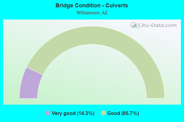
- Bridge Condition - Culverts
- 14.3%Very good
- 85.7%Good
Find on map >> Show street view
Structure Number: 6036, Location: 4.9 mi N Jct SR 89A (Lat: 34.678728, Lng: -112.442631), Route carried "on" structure: State highway 89, Year Built: 1961, Year Reconstructed: 2015, Status: Open, Structure Length: 0.98m (3.22ft), Average Daily Traffic: 24,501 (year 2019), Truck Traffic: 8%, Average Future Daily Traffic: 26,157 (year 2040), Design Load: HS 20, Features Intersected: Wash
Minimum Vertical Clearance: 30+ m (98+ ft), Kilometerpoint: 518.933, Lanes on structure: 4, Owner: State Highway Agency, Approaching Roadway Width: 12.2m (40.0ft), Skew: 10 degrees, Material/Design: Concrete continuous, Design/Construction: Culvert, Number Of Spans In Main Unit: 4, Length of Maximum Span: 3.0m (9.8ft), Curb-To-Curb Width: 12.2m (40.0ft), Out-to-Out Width: 17.0m (55.8ft)
Condition: Channel: Good, Culverts: Good, Operating Rating: 53.5 metric tons, Method Used To Determine Operating Rating: Load Factor (LF), Inventory Rating: 32.7 metric tons, Method Used To Determine Inventory Rating: Load Factor (LF), Structural Evaluation: Better than present minimum criteria, Deck Geometry: High priority of replacement, Waterway Adequacy: Equal to present desirable criteria, Approach Roadway Alignment: Equal to present desirable criteria, Length Of Structure Improvement: 5.67m (18.60ft), Designated Inspection Frequency: Every 48 months, Inspection Date: July 2021, Bridge Improvement Cost: $5,000, Total Project Cost: $5,000 ( Estimate for 2021)
Find on map >> Show street view
Structure Number: 9106, Location: 17.6 mi N Jct Iron Spr Rd (Lat: 34.773600, Lng: -112.608900), Route carried "on" structure: County highway , Year Built: 1937, Year Reconstructed: 1957, Status: Open, Structure Length: 3.02m (9.91ft), Average Daily Traffic: 362 (year 2020), Truck Traffic: 1%, Average Future Daily Traffic: 372 (year 2041), Design Load: HS 20, Features Intersected: Mint Wash, Facility Carried by Structure: Williamson Vly Rd
Minimum Vertical Clearance: 30+ m (98+ ft), Kilometerpoint: 0.000, Lanes on structure: 2, Owner: County Highway Agency, Approaching Roadway Width: 6.1m (20.0ft), Material/Design: Concrete continuous, Design/Construction: Slab, Number Of Spans In Main Unit: 5, Length of Maximum Span: 6.1m (20.0ft), Curb or Sidewalk Widths: Left: 0.2m (0.7ft), Right: 0.2m (0.7ft), Curb-To-Curb Width: 6.2m (20.3ft), Out-to-Out Width: 6.8m (22.3ft)
Condition: Deck: Satisfactory, Superstructure: Satisfactory, Substructure: Satisfactory, Channel: Good, Operating Rating: 47.2 metric tons, Method Used To Determine Operating Rating: Load Factor (LF), Inventory Rating: 28.1 metric tons, Method Used To Determine Inventory Rating: Load Factor (LF), Structural Evaluation: Equal to present minimum criteria, Deck Geometry: Meets minimum limits, Waterway Adequacy: Somewhat better than minimum adequacy, Approach Roadway Alignment: Equal to present desirable criteria, Length Of Structure Improvement: 3.84m (12.60ft), Designated Inspection Frequency: Every 24 months, Inspection Date: July 2021, Total Project Cost: $1,000 ( Estimate for 2021), Deck Structure Type: Concrete Cast-file-Place, Wearing Surface/Protective System: Wearing Surface: Epoxy Overlay
Find on map >> Show street view
Structure Number: 9107, Location: 21.9 mi N Jct Iron Spr Rd (Lat: 34.817975, Lng: -112.632178), Route carried "on" structure: County highway , Year Built: 1939, Status: Open, Structure Length: 5.18m (16.99ft), Average Daily Traffic: 150 (year 2021), Truck Traffic: 1%, Average Future Daily Traffic: 160 (year 2041), Design Load: H 15, Features Intersected: Williamson Valley Wash, Facility Carried by Structure: Williamson Vly Rd
Minimum Vertical Clearance: 30+ m (98+ ft), Kilometerpoint: 0.000, Lanes on structure: 2, Owner: County Highway Agency, Approaching Roadway Width: 6.7m (22.0ft), Skew: 3 degrees, Material/Design: Steel continuous, Design/Construction: Stringer/Multi-beam, Number Of Spans In Main Unit: 4, Length of Maximum Span: 13.7m (44.9ft), Curb or Sidewalk Widths: Left: 0.2m (0.7ft), Right: 0.2m (0.7ft), Curb-To-Curb Width: 6.7m (22.0ft), Out-to-Out Width: 7.6m (24.9ft)
Condition: Deck: Satisfactory, Superstructure: Good, Substructure: Satisfactory, Channel: Good, Operating Rating: 48.1 metric tons, Method Used To Determine Operating Rating: Load Factor (LF), Inventory Rating: 28.1 metric tons, Method Used To Determine Inventory Rating: Load Factor (LF), Structural Evaluation: Equal to present minimum criteria, Deck Geometry: Meets minimum limits, Waterway Adequacy: Equal to present minimum criteria, Approach Roadway Alignment: Equal to present desirable criteria, Length Of Structure Improvement: 6.07m (19.91ft), Designated Inspection Frequency: Every 24 months, Inspection Date: July 2021, Total Project Cost: $1,000 ( Estimate for 2021), Deck Structure Type: Concrete Cast-file-Place, Wearing Surface/Protective System: Wearing Surface: Monolithic Concrete
Find on map >> Show street view
Structure Number: 9602, Location: 18.1 mi N Jct Iron Spr Rd (Lat: 34.773300, Lng: -112.616200), Route carried "on" structure: County highway , Year Built: 1961, Status: Open, Structure Length: 0.70m (2.30ft), Average Daily Traffic: 362 (year 2020), Truck Traffic: 1%, Average Future Daily Traffic: 372 (year 2041), Design Load: HS 20, Features Intersected: BNSF RR, Facility Carried by Structure: Williamson Vly Rd
Minimum Vertical Clearance: 30+ m (98+ ft), Kilometerpoint: 0.000, Lanes on structure: 2, Owner: County Highway Agency, Approaching Roadway Width: 8.5m (27.9ft), Material/Design: Concrete, Design/Construction: Frame, Number Of Spans In Main Unit: 1, Length of Maximum Span: 3.0m (9.8ft), Curb-To-Curb Width: 10.4m (34.1ft), Out-to-Out Width: 11.0m (36.1ft)
Condition: Deck: Satisfactory, Superstructure: Satisfactory, Substructure: Good, Operating Rating: 54.4 metric tons, Method Used To Determine Operating Rating: Field evaluation and documented engineering judgment, Inventory Rating: 32.7 metric tons, Method Used To Determine Inventory Rating: Field evaluation and documented engineering judgment, Structural Evaluation: Equal to present minimum criteria, Deck Geometry: Better than present minimum criteria, Underclear: Meets minimum limits, Approach Roadway Alignment: Equal to present minimum criteria, Designated Inspection Frequency: Every 24 months, Inspection Date: July 2021, Deck Structure Type: Concrete Cast-file-Place, Wearing Surface/Protective System: Wearing Surface: Bituminous
Find on map >> Show street view
Structure Number: 10751, Location: 0.08 mi S of Inscr Cyn Dr (Lat: 34.740722, Lng: -112.563917), Route carried "on" structure: County highway , Year Built: 2000, Status: Open, Structure Length: 1.16m (3.81ft), Average Daily Traffic: 110 (year 2019), Truck Traffic: 1%, Average Future Daily Traffic: 120 (year 2039), Design Load: HS 20, Features Intersected: Cooper Wash, Facility Carried by Structure: Warpaint Place
Minimum Vertical Clearance: 30+ m (98+ ft), Kilometerpoint: 0.000, Lanes on structure: 2, Owner: County Highway Agency, Approaching Roadway Width: 6.1m (20.0ft), Skew: 1 degrees, Material/Design: Steel, Design/Construction: Culvert, Number Of Spans In Main Unit: 7, Length of Maximum Span: 1.5m (4.9ft)
Condition: Channel: Good, Culverts: Good, Operating Rating: 64.4 metric tons, Method Used To Determine Operating Rating: Load Factor (LF), Inventory Rating: 37.2 metric tons, Method Used To Determine Inventory Rating: Load Factor (LF), Structural Evaluation: Better than present minimum criteria, Waterway Adequacy: Better than present minimum criteria, Approach Roadway Alignment: Somewhat better than minimum adequacy, Designated Inspection Frequency: Every 48 months, Inspection Date: July 2019
Find on map >> Show street view
Structure Number: 10755, Location: 0.6 mi E of Will. Vly Rd (Lat: 34.652778, Lng: -112.505556), Route carried "on" structure: County highway , Year Built: 1990, Status: Open, Structure Length: 1.10m (3.61ft), Average Daily Traffic: 527 (year 2019), Truck Traffic: 1%, Average Future Daily Traffic: 537 (year 2039), Design Load: HS 20, Features Intersected: Wash, Facility Carried by Structure: Glenshandra Dr
Minimum Vertical Clearance: 30+ m (98+ ft), Kilometerpoint: 0.000, Lanes on structure: 2, Owner: County Highway Agency, Approaching Roadway Width: 7.3m (24.0ft), Skew: 2 degrees, Material/Design: Concrete continuous, Design/Construction: Culvert, Number Of Spans In Main Unit: 3, Length of Maximum Span: 3.0m (9.8ft)
Condition: Channel: Good, Culverts: Very good, Operating Rating: 63.5 metric tons, Method Used To Determine Operating Rating: Load Factor (LF), Inventory Rating: 38.1 metric tons, Method Used To Determine Inventory Rating: Load Factor (LF), Structural Evaluation: Equal to present desirable criteria, Waterway Adequacy: Better than present minimum criteria, Approach Roadway Alignment: Better than present minimum criteria, Designated Inspection Frequency: Every 48 months, Inspection Date: July 2019
Find on map >> Show street view
Structure Number: 10756, Location: 0.3 mi W of Will. Vly Rd (Lat: 34.652778, Lng: -112.522222), Route carried "on" structure: County highway , Year Built: 1995, Status: Open, Structure Length: 0.85m (2.79ft), Average Daily Traffic: 110 (year 2019), Truck Traffic: 1%, Average Future Daily Traffic: 120 (year 2039), Design Load: HS 20, Features Intersected: Wash, Facility Carried by Structure: Granite Park Dr
Minimum Vertical Clearance: 30+ m (98+ ft), Kilometerpoint: 0.000, Lanes on structure: 2, Owner: County Highway Agency, Approaching Roadway Width: 7.6m (24.9ft), Skew: 2 degrees, Material/Design: Concrete continuous, Design/Construction: Culvert, Number Of Spans In Main Unit: 2, Length of Maximum Span: 3.7m (12.1ft)
Condition: Channel: Good, Culverts: Good, Operating Rating: 62.6 metric tons, Method Used To Determine Operating Rating: Load Factor (LF), Inventory Rating: 37.2 metric tons, Method Used To Determine Inventory Rating: Load Factor (LF), Structural Evaluation: Better than present minimum criteria, Waterway Adequacy: Better than present minimum criteria, Approach Roadway Alignment: Somewhat better than minimum adequacy, Designated Inspection Frequency: Every 48 months, Inspection Date: July 2019, Deck Structure Type: Concrete Cast-file-Place, Wearing Surface/Protective System: Wearing Surface: Bituminous
Find on map >> Show street view
Structure Number: 10757, Location: at Merril Dr crossing (Lat: 34.636111, Lng: -112.505556), Route carried "on" structure: County highway , Year Built: 1973, Status: Open, Structure Length: 0.98m (3.22ft), Average Daily Traffic: 11,505 (year 2019), Truck Traffic: 1%, Average Future Daily Traffic: 11,515 (year 2039), Design Load: HS 20, Features Intersected: Wash, Facility Carried by Structure: Williamson Vly Rd
Minimum Vertical Clearance: 30+ m (98+ ft), Kilometerpoint: 0.000, Lanes on structure: 2, Owner: County Highway Agency, Approaching Roadway Width: 8.5m (27.9ft), Material/Design: Concrete continuous, Design/Construction: Culvert, Number Of Spans In Main Unit: 3, Length of Maximum Span: 3.0m (9.8ft)
Condition: Channel: Good, Culverts: Good, Operating Rating: 89.8 metric tons, Method Used To Determine Operating Rating: Load Factor (LF), Inventory Rating: 76.2 metric tons, Method Used To Determine Inventory Rating: Load Factor (LF), Structural Evaluation: Better than present minimum criteria, Waterway Adequacy: Better than present minimum criteria, Approach Roadway Alignment: Better than present minimum criteria, Designated Inspection Frequency: Every 48 months, Inspection Date: July 2019
Find on map >> Show street view
Structure Number: 10772, Location: 0.3 mi W of Will. Val. Rd (Lat: 34.742500, Lng: -112.568028), Route carried "on" structure: County highway , Year Built: 2000, Status: Open, Structure Length: 1.43m (4.69ft), Average Daily Traffic: 464 (year 2019), Truck Traffic: 1%, Average Future Daily Traffic: 474 (year 2039), Design Load: HS 20, Features Intersected: Cooper Wash, Facility Carried by Structure: Inscription Cyn Dr
Minimum Vertical Clearance: 30+ m (98+ ft), Kilometerpoint: 0.000, Lanes on structure: 2, Owner: County Highway Agency, Approaching Roadway Width: 8.5m (27.9ft), Skew: 1 degrees, Material/Design: Steel, Design/Construction: Culvert, Number Of Spans In Main Unit: 6, Length of Maximum Span: 1.8m (5.9ft)
Condition: Channel: Good, Culverts: Good, Operating Rating: 64.4 metric tons, Method Used To Determine Operating Rating: Load Factor (LF), Inventory Rating: 37.2 metric tons, Method Used To Determine Inventory Rating: Load Factor (LF), Structural Evaluation: Better than present minimum criteria, Waterway Adequacy: Better than present minimum criteria, Approach Roadway Alignment: Somewhat better than minimum adequacy, Designated Inspection Frequency: Every 48 months, Inspection Date: July 2019
Find on map >> Show street view
Structure Number: 10774, Location: 1.3 mi E W. Valley Rd (Lat: 34.705556, Lng: -112.519444), Route carried "on" structure: County highway , Year Built: 1979, Status: Open, Structure Length: 1.37m (4.49ft), Average Daily Traffic: 3,141 (year 2019), Truck Traffic: 1%, Average Future Daily Traffic: 3,151 (year 2019), Design Load: HS 20, Features Intersected: Wash, Facility Carried by Structure: Outer Loop Rd
Minimum Vertical Clearance: 30+ m (98+ ft), Kilometerpoint: 0.000, Lanes on structure: 2, Owner: County Highway Agency, Approaching Roadway Width: 8.5m (27.9ft), Material/Design: Steel, Design/Construction: Culvert, Number Of Spans In Main Unit: 8, Length of Maximum Span: 1.5m (4.9ft)
Condition: Channel: Good, Culverts: Good, Operating Rating: 89.8 metric tons, Method Used To Determine Operating Rating: Load Factor (LF), Inventory Rating: 89.8 metric tons, Method Used To Determine Inventory Rating: Load Factor (LF), Structural Evaluation: Better than present minimum criteria, Waterway Adequacy: Better than present minimum criteria, Approach Roadway Alignment: Better than present minimum criteria, Designated Inspection Frequency: Every 48 months, Inspection Date: July 2019